indians of virginia (pre-1600 with notes on historic tribes)
TRANSCRIPT

1
Indians of Virginia (Pre-1600 With Notes on Historic Tribes)
Virginia History Series
#1-09 © 2009

2
Pre-Historic Times in 3 Periods (14,000 B.P.- 1,600 A.D.):Paleoindian
Pre-Clovis (14,000 BP – 9,500 B.C.)
Clovis (9,500 – 8,000 B.C.)
Archaic
Early (8,000 -6,000 B.C.)
Middle (6,000 – 2,500 B.C.)
Late (2,500 – 1,200 B.C.)
Woodland
Early (1,200 – 500 B.C.)
Middle (500 B.C. – 900 A.D.)
Late (900 – 1,600 A.D.)
Mississippian Culture (Influence of)
Tribes of Virginia

3
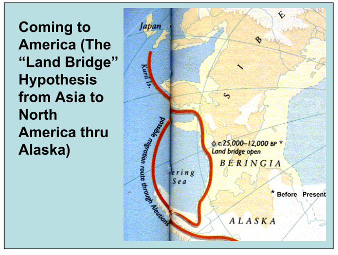
Alternate Hypotheses about Pre-historic Migration Routes taken by Paleo-Indians from Asia or Europe into North America: (1) From Asia by Water along the Northern Pacific or across the land bridge from Asia thru Alaska/Canada; or (2) From Europe on the edge of the ice pack along the North Atlantic Coast to the Temperate Lands below the Laurentide Ice Sheet.
4
Coming to America (The “Land Bridge”Hypothesis from Asia to North America thru Alaska) *
* Before Present

5
Migrations into North and Central America from Asia via Alaska
6
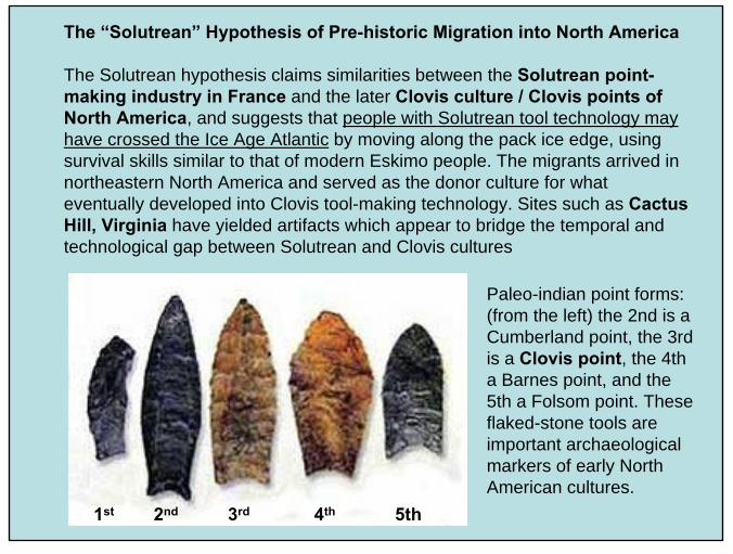
The “Solutrean” Hypothesis of Pre-historic Migration into North America
The Solutrean hypothesis claims similarities between the Solutrean point-making industry in France and the later Clovis culture / Clovis points of North America, and suggests that people with Solutrean tool technology may have crossed the Ice Age Atlantic by moving along the pack ice edge, using survival skills similar to that of modern Eskimo people. The migrants arrived in northeastern North America and served as the donor culture for what eventually developed into Clovis tool-making technology. Sites such as Cactus Hill, Virginia have yielded artifacts which appear to bridge the temporal and technological gap between Solutrean and Clovis cultures
Paleo-indian point forms: (from the left) the 2nd is a Cumberland point, the 3rd is a Clovis point, the 4th a Barnes point, and the 5th a Folsom point. These flaked-stone tools are important archaeological markers of early North American cultures.
1st 2nd 3rd 4th 5th

7
Pre-Historic Indian Spear Points from Solutre, France (i.e., Solutrean); Cactus Hill, VA; and Clovis, NM
8
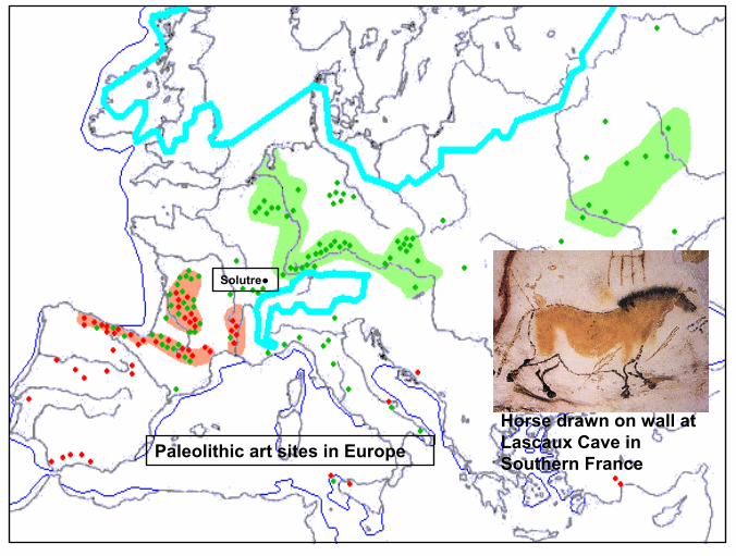
Paleolithic art sites in Europe
Solutre●
Horse drawn on wall at Lascaux Cave in Southern France
9
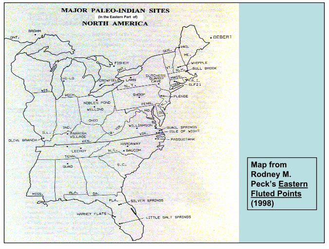
Map from Rodney M. Peck’s Eastern Fluted Points(1998)
(In the Eastern Part of)
10
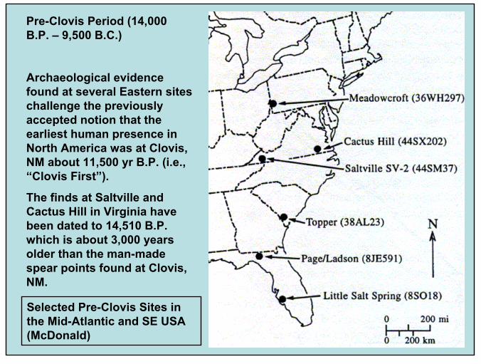
Pre-Clovis Period (14,000 B.P. – 9,500 B.C.)
Archaeological evidence found at several Eastern sites challenge the previously accepted notion that the earliest human presence in North America was at Clovis, NM about 11,500 yr B.P. (i.e., “Clovis First”).
The finds at Saltville and Cactus Hill in Virginia have been dated to 14,510 B.P. which is about 3,000 years older than the man-made spear points found at Clovis, NM.
Selected Pre-Clovis Sites in the Mid-Atlantic and SE USA (McDonald)

11
Pre-Clovis at the Cactus Hill Site [44SX202] (45 mi So. Of Richmond, VA)
[Site below; stone tools found at right; artist’s conception of the native environment – below rt]

12
Pre-Clovis at Saltville, Virginia [44SM37]
Saltville Valley is an important source of information about the environmental history of the Middle Appalachian region, especially for the past thousands of years.
The Saltville River ran thru the valley until about 13,500-13,000 yrs BP, at which time it was diverted by headstream piracy and replaced in Saltville Valley by Lake Totten.
At Saltville, three horizons dating from 14,510 +/- 80 yr BP to about 13,500-13,000 yr BP document the presence of pre-Clovis people in Saltville Valley and provide insight into their life-ways.
Saltville Sites
SV-1SV-2
Satellite View of Sites inSquare Section Above
* *

13
Pre-Clovis “Bone Tool” ca. 14,520 years B.P. from Saltville, Virginia (Site SV-2)
Diagram of generalized tool showing parts (above); “Bone tool” (right) with picture of blade edge above showing striations probably made by abrasive contact with animal tissue. (Circular incision in blade was made where bone samples were taken for radiometric dating.) [McDonald]

14
The pre-Clovis people at Saltville appear to have butchered and processed hide, meat, bones, and tusks of a mastodon and to have utilized parts of the skeleton of a musk ox.Five hundred years later, at 13,950 +/- 70 yr BP, human presence is suggested by unlikely arrangements, associations, and modifications of lithics, including flakes of chert that resemble bio-face reduction flakes.
This Saltville site is one of the few and most complex pre-Clovis archeological sites in North America. Evidence suggests that the pre-Clovis people who visited Saltville Valley in 14,510 yr BP had a diversified ivory, bone, and lithic technology--possibly including a bifacetechnology. These people appear to have been mobile hunters and gatherers who regularly visited and exploited the riparian and littoral zones in Saltville Valley where they utilized diverse animal resources ranging from large mammals to small mammals, reptiles, amphibians, fish, and mussels.
Mastodon (above);Musk Ox (below)

15
Paleo-Indian Hunting Diorama (Johnson-Humrickhouse Museum)

16
Clovis Period in the Eastern Woodlands
(9,500-8,000 B.C.)
There is evidence of native American hunters in Virginia’s woodlands for thousands of years.
Flint Run Complex in the Northern Shenandoah Valley (i.e., a “stone tool making” site) including: a Jasper Quarry on Flint Run; Lockhart and Gooney Run Sites for stone reduction; the Thunderbird Paleoindian Site used as a base camp; and several maintenance sites – e.g., the Fifty Site). All these sites are in Warren Co., VA
Williamson “Workshop” Site in Dinwiddie Co., VA and the nearby Isle of Wight “Camp” Site (i.e., both in SE Virginia)

17
Flint Run Complex in the Northern Shenandoah Valley of Virginia
This is a group of Clovis sites clustered around a jasper outcrop near the South Fork of the Shenandoah river in the Northern Shenandoah valley of Virginia accounting for between 500 to 1,000 people at circa 8,300 BC. Site types include habitations and stone tool workshops.
18
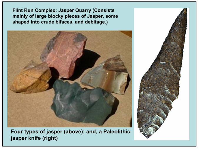
Four types of jasper (above); and, a Paleolithic jasper knife (right)
Flint Run Complex: Jasper Quarry (Consists mainly of large blocky pieces of Jasper, some shaped into crude bifaces, and debitage.)

19
Flint Run Complex: Lockhart and Gooney Run Sites
These sites contain mostly further reduced and shaped bifaces that are still, however, mainly in the early stages of reduction, as is evident in the common occurence of primary flakes.
Tools are rare at both sites.
Complex Geography
The Shenandoah River cuts through the center of the site complex. The Jasper outcrop is on the South side of the river. The Thunderbird base camp is located on the North side of the river. The Reduction Stations (i.e., Lockhart and Gooney Run) are close to the quarry but adjacent to the nearest available water. All sites are underlain by limestone.
The distance from Thunderbird to Lockart is about 500 ft, and from Lockhart to the Jasper outcrops is about 100 ft. The total area for all known sites is not more than 0.25 mi x 2 mi making the area included in the complex about 0.5 sq miles.

20
Flint Run Complex: Thunderbird Site
This was a “base camp”containing preliminarily shaped and transported bifaces and cores to nearly finished and finished late-stage bifaces, preforms and broken unused points, and discarded, extensively curated points of nonlocal materials.
Artist’s reconstruction of activity at the Thunderbird site (i.e., men chipping new stone tools sit by the river’s edge. (Garnder)
21
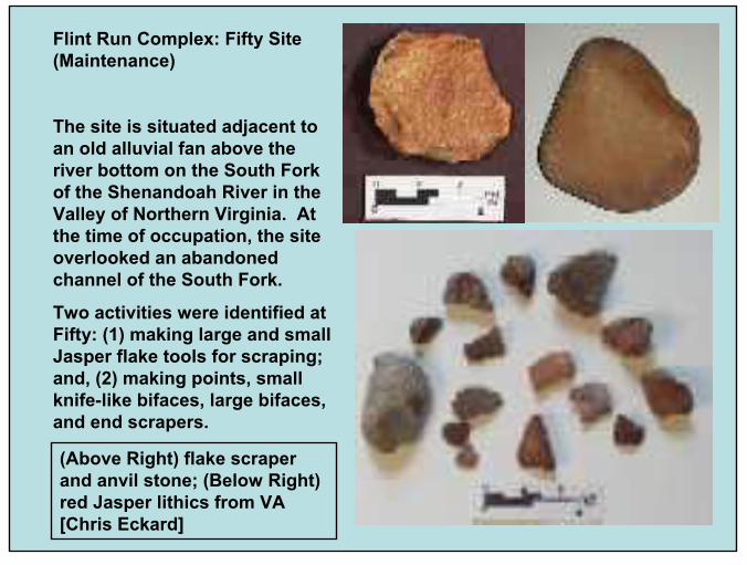
Flint Run Complex: Fifty Site (Maintenance)
The site is situated adjacent to an old alluvial fan above the river bottom on the South Fork of the Shenandoah River in the Valley of Northern Virginia. At the time of occupation, the site overlooked an abandoned channel of the South Fork.
Two activities were identified at Fifty: (1) making large and small Jasper flake tools for scraping; and, (2) making points, small knife-like bifaces, large bifaces, and end scrapers.
(Above Right) flake scraper and anvil stone; (Below Right) red Jasper lithics from VA [Chris Eckard]

22
Williamson “Workshop” Site, Quail Springs Site, and the Isle of Wight “Camp” Site in SE Virginia [Rodney M. Peck]
23
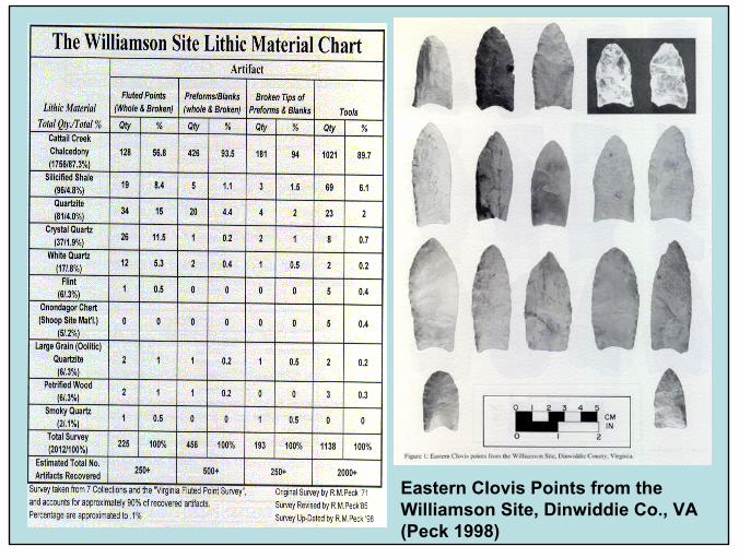
Eastern Clovis Points from the Williamson Site, Dinwiddie Co., VA (Peck 1998)
24
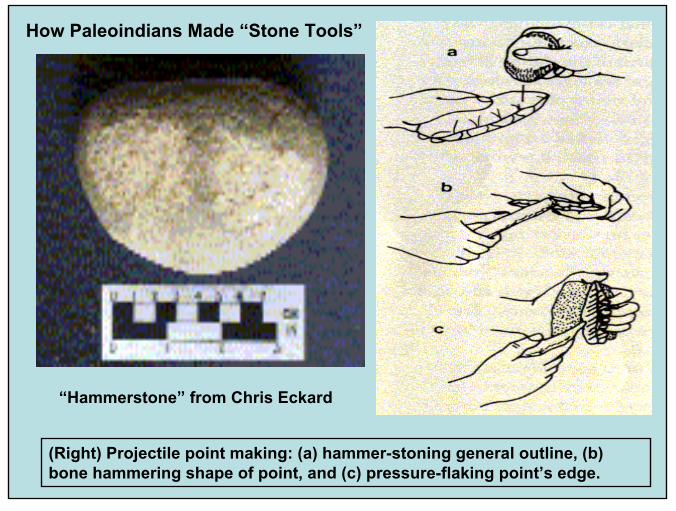
(Right) Projectile point making: (a) hammer-stoning general outline, (b) bone hammering shape of point, and (c) pressure-flaking point’s edge.
How Paleoindians Made “Stone Tools”
“Hammerstone” from Chris Eckard
25
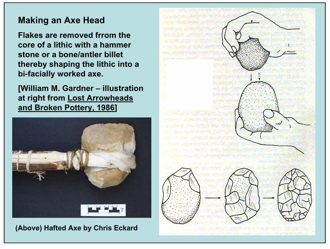
Making an Axe HeadFlakes are removed frrom the core of a lithic with a hammer stone or a bone/antler billet thereby shaping the lithic into a bi-facially worked axe.
[William M. Gardner – illustration at right from Lost Arrowheads and Broken Pottery, 1986]
(Above) Hafted Axe by Chris Eckard

26
Creating a Stone-age Axe Head – Animation by Chris Eckard

27
Using a Stone-age Scraper Tool – Animation by Chris Eckard
28
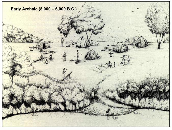
Early Archaic (8,000 – 6,000 B.C.)

29
Middle Archaic (6,000 – 2,500 B.C.)
Early Hunters used an “Atlatl” to increase the throwing power of their spears. These devices had stone weights (circled) for balance and to get greater momentum into the spear.

30
Middle Archaic People used pestles and mortars (below) to grind nuts, seeds and corn into powder before cooking/eating.

31
Late Archaic (2,500 – 1,200 B.C.) People Were “Sedentary Foragers”

32
Soapstone
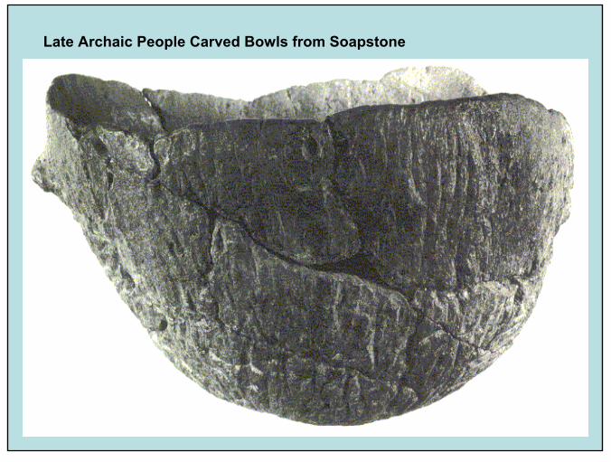
Originally what would become soapstone was an igneous rock. Later, it was metamorphosed to a rock which contains the mineral talc giving it its characteristic soapy feel.
Soapstone is so soft that it can be cut in pieces and then fashioned into various objects. It has excellent heat-retaining properties making it useful in the manufacture of cooking bowls.
It has been used as a dimension stone in the building industry. The largest soapstone quarries in the US are on the line between Albemarle & Nelson counties just West of Green Mount, VA.
Schuyler, VA was the center of a large soapstone industry earlier in the 20th century. Soapstone above from Schuyler,
VA; Unfinished bowl shown below in an exposed soapstone bolder.
33
Late Archaic People Carved Bowls from Soapstone
34
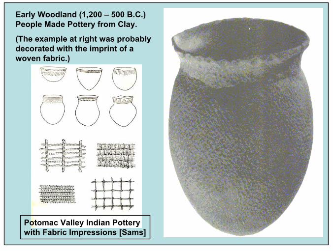
Early Woodland (1,200 – 500 B.C.) People Made Pottery from Clay.
(The example at right was probably decorated with the imprint of a woven fabric.)
Potomac Valley Indian Pottery with Fabric Impressions [Sams]

35
Middle Woodland (500 B.C. – 900 A.D.)
Beginnings of “Ranked Societies”

36
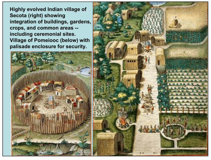
Late Woodland (900 – 1,600 A.D.) People Were Farmers and Lived in Permanent Villages (Houses Were Shared Longhouses or Single-Family Dome Shaped Structures)
37
Highly evolved Indian village of Secota (right) showing integration of buildings, gardens, crops, and common areas --including ceremonial sites. Village of Pomeiooc (below) with palisade enclosure for security.
38
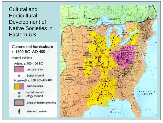
Cultural and Horticultural Development of Native Societies in Eastern US
39
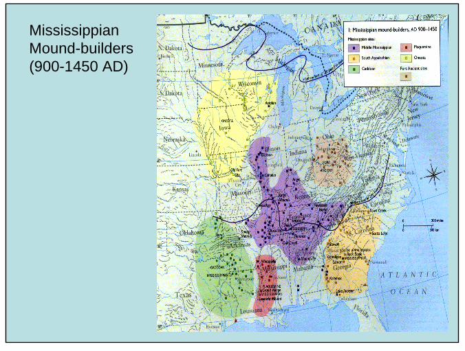
Mississippian Mound-builders (900-1450 AD)
40
41
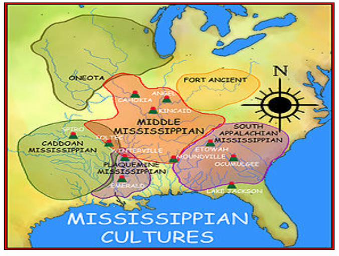
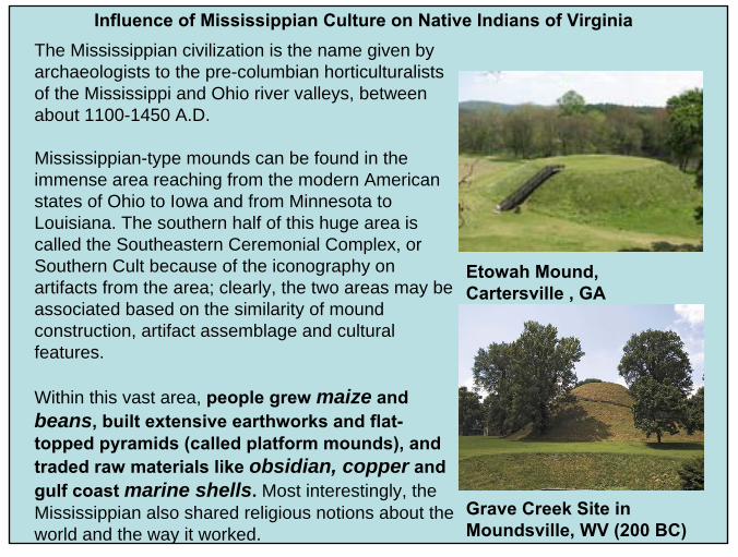
Influence of Mississippian Culture on Native Indians of VirginiaThe Mississippian civilization is the name given by archaeologists to the pre-columbian horticulturalists of the Mississippi and Ohio river valleys, between about 1100-1450 A.D.
Mississippian-type mounds can be found in the immense area reaching from the modern American states of Ohio to Iowa and from Minnesota to Louisiana. The southern half of this huge area is called the Southeastern Ceremonial Complex, or Southern Cult because of the iconography on artifacts from the area; clearly, the two areas may be associated based on the similarity of mound construction, artifact assemblage and cultural features.
Within this vast area, people grew maize and beans, built extensive earthworks and flat-topped pyramids (called platform mounds), and traded raw materials like obsidian, copper and gulf coast marine shells. Most interestingly, the Mississippian also shared religious notions about the world and the way it worked.
Etowah Mound, Cartersville , GA
Grave Creek Site in Moundsville, WV (200 BC)
42
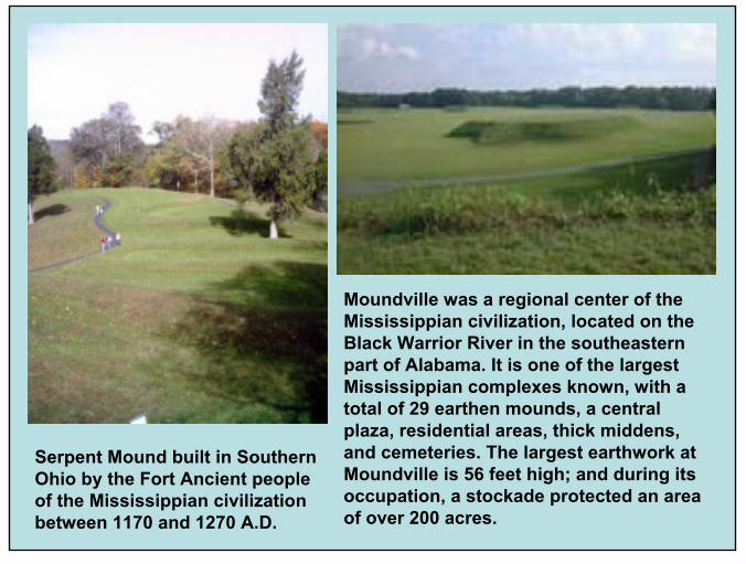
Serpent Mound built in Southern Ohio by the Fort Ancient people of the Mississippian civilizationbetween 1170 and 1270 A.D.
Moundville was a regional center of the Mississippian civilization, located on the Black Warrior River in the southeastern part of Alabama. It is one of the largest Mississippian complexes known, with a total of 29 earthen mounds, a central plaza, residential areas, thick middens, and cemeteries. The largest earthwork at Moundville is 56 feet high; and during its occupation, a stockade protected an area of over 200 acres.
43
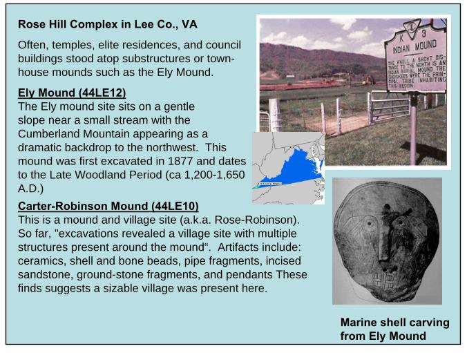
Rose Hill Complex in Lee Co., VA
Often, temples, elite residences, and council buildings stood atop substructures or town-house mounds such as the Ely Mound.
Ely Mound (44LE12)The Ely mound site sits on a gentleslope near a small stream with the Cumberland Mountain appearing as a dramatic backdrop to the northwest. This mound was first excavated in 1877 and dates to the Late Woodland Period (ca 1,200-1,650 A.D.)
Marine shell carving from Ely Mound
Carter-Robinson Mound (44LE10)This is a mound and village site (a.k.a. Rose-Robinson). So far, "excavations revealed a village site with multiple structures present around the mound“. Artifacts include: ceramics, shell and bone beads, pipe fragments, incised sandstone, ground-stone fragments, and pendants These finds suggests a sizable village was present here.

44
Ely Mound was first excavated in 1877 by Lucien Carr of the Peabody Museum in Boston, MA

45
Artifacts found at Ely Mound (from Lucien Carr’s Report to the Peabody Museum – 1880)
Round Stone above used in the Indian game of “Chunke”
Late Woodland Period (1,200 to 1,650 A.D.)
46
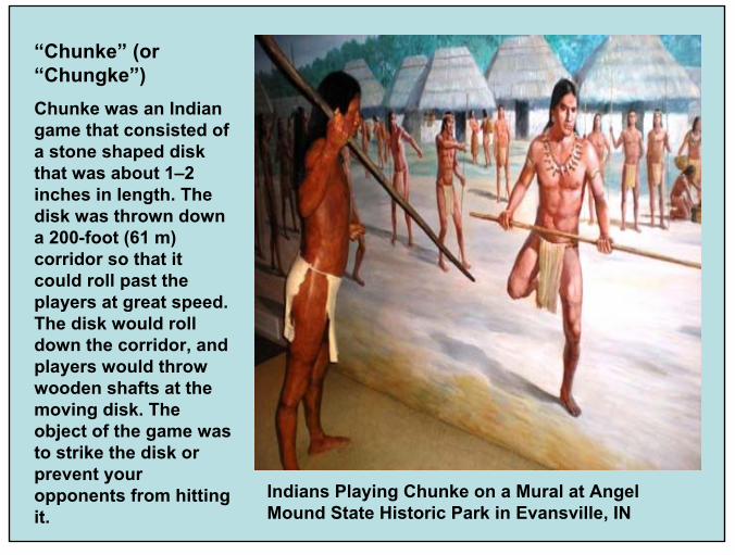
“Chunke” (or “Chungke”)Chunke was an Indian game that consisted of a stone shaped disk that was about 1–2 inches in length. The disk was thrown down a 200-foot (61 m) corridor so that it could roll past the players at great speed. The disk would roll down the corridor, and players would throw wooden shafts at the moving disk. The object of the game was to strike the disk or prevent your opponents from hitting it.
Indians Playing Chunke on a Mural at Angel Mound State Historic Park in Evansville, IN
47
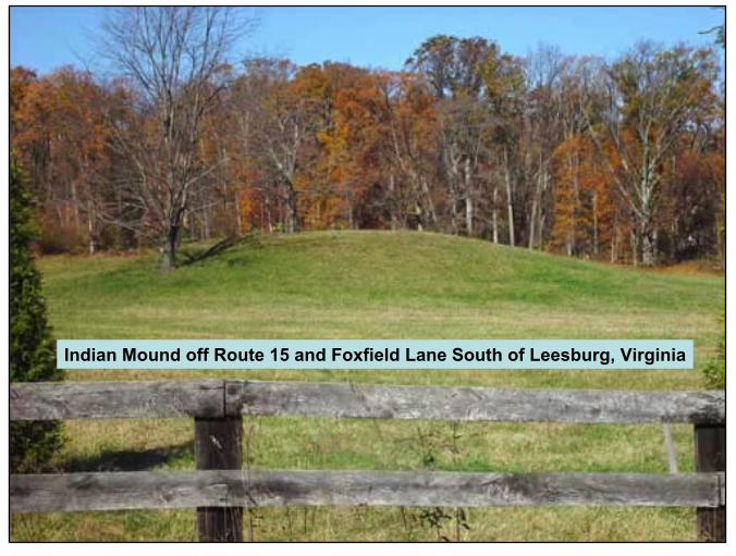
Indian Mound off Route 15 and Foxfield Lane South of Leesburg, Virginia
48
49

50
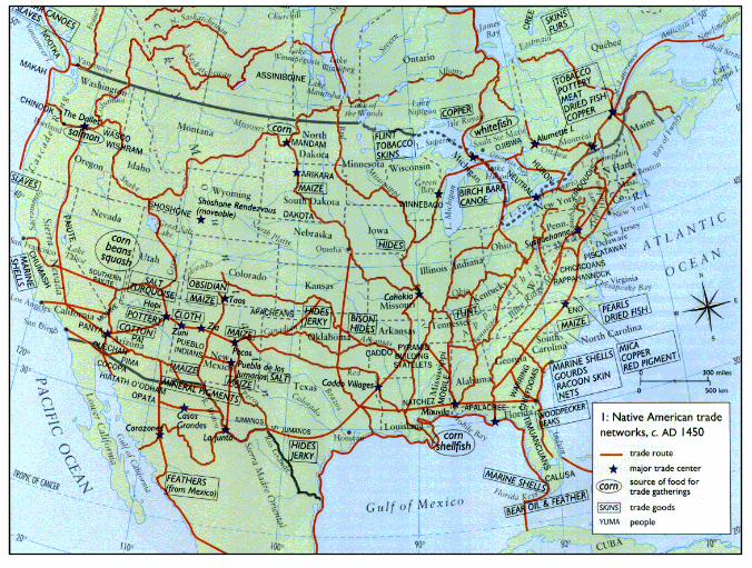
Indian Trading Paths and Goods (map by H. H. Tanner in Powhatan’s Mantle)Typical trade goods included:
Salt, Copper, Marine Shell, Pottery, Animal Skins, Arrow/Spear Points, etc.
Copper Tinkler
Rock Salt

51
River-based Horticultural Chiefdoms in Southern & Eastern North America (brown areas)
52
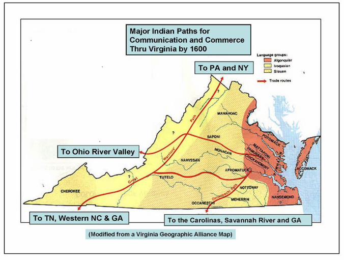
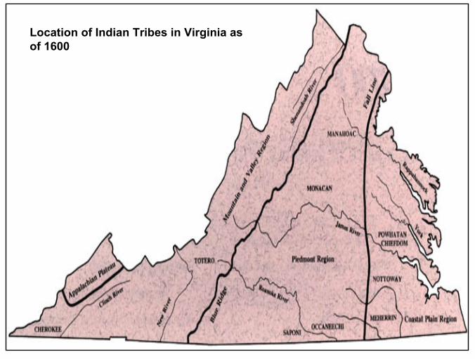
Location of Indian Tribes in Virginia as of 1600

53
54
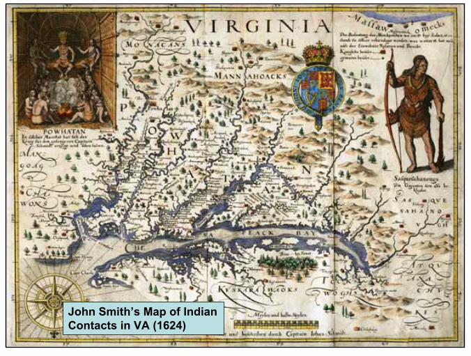
John Smith’s Map of Indian Contacts in VA (1624)

55
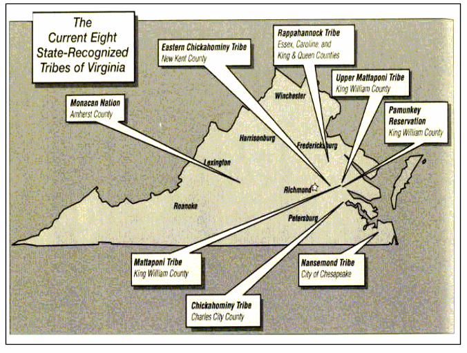
Recognized Indian Tribes of Virginia
8 Tribes Recognized by the State of Virginia as of May 2008:
Chickahominy
Eastern Chickahominy
Mattaponi
Monacan Indian Nation
Nansemond
Pamunkey
Rappahannock
Upper Mattaponi
Aerial View of the WerowocomocoVillage Site on York River (Capitol of the Powhatan Chiefdom)
56
57
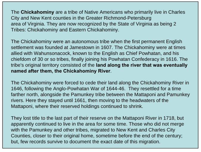
The Chickahominy are a tribe of Native Americans who primarily live in Charles City and New Kent counties in the Greater Richmond-Petersburgarea of Virginia. They are now recognized by the State of Virginia as being 2 Tribes: Chickahominy and Eastern Chickahominy.
The Chickahominy were an autonomous tribe when the first permanent English settlement was founded at Jamestown in 1607. The Chickahominy were at times allied with Wahunsonacock, known to the English as Chief Powhatan, and his chiefdom of 30 or so tribes, finally joining his Powhatan Confederacy in 1616. The tribe's original territory consisted of the land along the river that was eventually named after them, the Chickahominy River.
The Chickahominy were forced to cede their land along the Chickahominy River in 1646, following the Anglo-Powhatan War of 1644-46. They resettled for a time farther north, alongside the Pamunkey tribe between the Mattaponi and Pamunkeyrivers. Here they stayed until 1661, then moving to the headwaters of the Mattaponi, where their reserved holdings continued to shrink.
They lost title to the last part of their reserve on the Mattaponi River in 1718, but apparently continued to live in the area for some time. Those who did not merge with the Pamunkey and other tribes, migrated to New Kent and Charles City Counties, closer to their original home, sometime before the end of the century; but, few records survive to document the exact date of this migration.

58
Eastern ChickahominyOriginally located along the Chickahominy River from the James River to NW of Henrico City – i.e., Richmond, VA.
John Smith meeting with Eastern Chickahominy Indians (above)
Chickahominy River

59
(Western) Chickahominy
Originally located along the Chickahominy River from NW of Henrico City ( i.e., Richmond, VA) to its headwaters in central Virginia.
Present-day Chickahominy Tribal Dancer
60
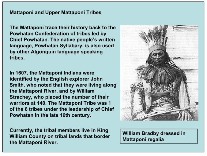
Mattaponi and Upper Mattaponi Tribes
The Mattaponi trace their history back to the Powhatan Confederation of tribes led by Chief Powhatan. The native people’s written language, Powhatan Syllabary, is also used by other Algonquin language speaking tribes.
In 1607, the Mattaponi Indians were identified by the English explorer John Smith, who noted that they were living along the Mattaponi River, and by William Strachey, who placed the number of their warriors at 140. The Mattaponi Tribe was 1 of the 6 tribes under the leadership of Chief Powhatan in the late 16th century.
Currently, the tribal members live in King William County on tribal lands that border the Mattaponi River.
William Bradby dressed in Mattaponi regalia
61
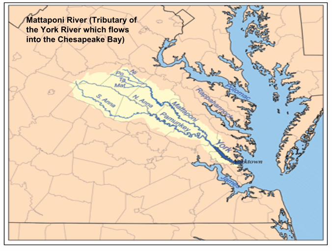
Mattaponi River (Tributary of the York River which flows into the Chesapeake Bay)

62
“Mattapament Flu” (i.e., River) and Indian Villages on John Smith’s Map of VA in 1624
63
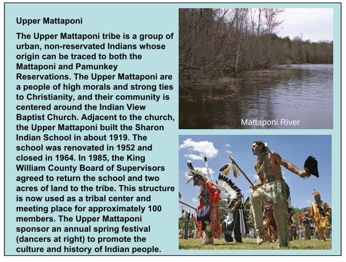
Upper Mattaponi
The Upper Mattaponi tribe is a group of urban, non-reservated Indians whose origin can be traced to both the Mattaponi and PamunkeyReservations. The Upper Mattaponi are a people of high morals and strong ties to Christianity, and their community is centered around the Indian View Baptist Church. Adjacent to the church, the Upper Mattaponi built the Sharon Indian School in about 1919. The school was renovated in 1952 and closed in 1964. In 1985, the King William County Board of Supervisors agreed to return the school and two acres of land to the tribe. This structure is now used as a tribal center and meeting place for approximately 100 members. The Upper Mattaponi sponsor an annual spring festival (dancers at right) to promote the culture and history of Indian people.
Mattaponi River

64
Mattaponi Pottery
(Very Rare)

65
Monacan Indian Nation
The Monacan are a group of people of mixed ancestry recognized as a Native Americantribe by the state of Virginia.
They are located primarily in Amherst County, Virginia near Lynchburg, Virginia. As of 2005 there were approximately 1,400 members of this tribe. There are also satellite groups in West Virginia, Maryland, and Ohio.
The contemporary Monacan people claim to be descendants of an Eastern Siouan tribe of American Indians, first recorded in 1607 in Virginia. They are related to the Tutelo, Saponi.
In 1607, the Monacan were living above the falls at present-day Richmond and were reportedly hostile to other tribes of the Powhatan confederacy in the area.
In 1608, the English found two Monacan towns above the falls, called Massinacak and Mowhemenchough.
All these Monacan groups were closely related with the Siouan Manahoac to their north.
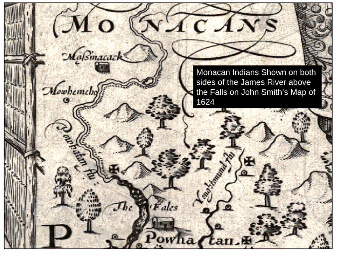
66
Monacan Indians Shown on both sides of the James River above the Falls on John Smith’s Map of 1624

67
Nansemond
Nansemond refers to a group of people of mixed ancestry, who have been recognized as a Native American tribe bythe Commonwealth of Virginia, along with 7 other tribes in the state.
The Nansemond are Algonquian speaking natives and have traditionally lived along the Nansemond River in what is now the independent city of Suffolk, Virginia.
Historically, the Nansemond tribe was known for fishing, growing corn and bear hunting. Today they are known for their annual “pow wows” which are held in both Suffolk and Chesapeake, Virginia.
Swampy Environment near Suffolk, VA
Grand Procession at Annual Pow Wow

68
“Nandsamund”Ancestral Village Shown on John Smith’s Map of 1624

69
Pamunkey
At the time of the settlement of Jamestown, in 1607, that region lying in Virginia between Potomac and James rivers was occupied by three great Indian confederacies: (1) the Mannahoac; (2) the Monocan; and (3) the Powhatan, who inhabited all that portion of the tidewater region lying north of the James River.
The largest of the 30 tribes making up the Powhatan confederacy was the Pamunkey, The original seat of the Pamunkeytribe was on the banks of the river which bears their name, and which flows somewhat parallel with James river into the Chesapeake Bay. Indian Villages on the Pamunkey River
from John Smith’s Map of 1624

70
Pamunkey Indian Reservation Petition, King William County, Va., 6/26/1893.
“We, are the last descendants of the Powhatan tribe of Indians, now situated on a small reservation on the Pamunkey river, 24 miles from Richmond, Va., and one mile east of the historic White House where Gen. George Washington was married to his lovely bride in the St. Peter's Church.
We are now known as the Pamunkey tribe of Indians, following the customs of our forefathers, hunting and fishing, partly with our dugout canoes. We hereby authorize Terrill BRADBY to visit the Indian Bureau in Washington and in all other Departments and Indian tribes, and also to visit the Columbian Exposition in Chicago. We the undersigned, also request that whenever this petition is presented, the holder may meet with the favorable approbation of the public generally.”
Pamunkey Indians on Reservation Digging Clay for Pottery

71
Rappahannock
In 1607, the Rappahannock were the dominant tribe of the Rappahannock River valley, maintaining thirteen villages along the north and south banks of the river named after them. Their capital town was Topahanocke(or Tappahannock circled on map). They were a peripheral group within the Powhatan Confederacy.
At their 1st meeting with the English in 1607, George Percy wrote a vivid description of their Chief having his body painted crimson, and his face painted blue sprinkled with silver. He wore a red deer-hair crown tied around his hair knot and a copper plate on the other side, with two feathers sticking up arranged like horns, and earrings made of bird-claws fastened with yellow metal. Indian Villages on “Tappahamock” River
from John Smith’s Map of 1624

72
The Rappahannock Tribe has occupied the Rappahannock Rivernamed by the tribe for 11,000 years. Their lands span from the Northern Neck on theRappahannock to the Mattaponi Rivers and as far north as Fredericksburg, Virginia.

73
Today's Rappahannock Tribe consists of a few hundred descendants of the original Rappahannock, Morattico (Maraughtacund), Portobacco, andDoeg tribes who merged in the late 17th century. Most tribe members now live in Essex, Caroline and King and Queen counties. [Tribal Dancers below – 8/26/2006]

74
Unrecognized, Extinct, or Tribes No Longer Located in Virginia:
Patowmeck (A)
*Powhatan (A)
Tuscarora (I)
*Tutelo & Saponi (S)
Wicomico (A)
*Yuchi or Westo (Uchean)
Language Groups: A = Algonquian; S = Siouan;I = Iroquoian
* = Representative tribes featured in this historical review
Assateaque (A)
Ani-Stohini/Unami (A)
Appomatoc (A)
Catawba (S)
*Cherokee (I)
Croatan (A)
Manahoac (S)
Meherrin (I)
Nottaway (I)
Occaneechi (S)
Paspahegh (A)

75

76
77
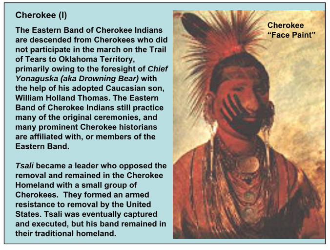
Cherokee (I)The Eastern Band of Cherokee Indians are descended from Cherokees who did not participate in the march on the Trail of Tears to Oklahoma Territory, primarily owing to the foresight of Chief Yonaguska (aka Drowning Bear) with the help of his adopted Caucasian son, William Holland Thomas. The Eastern Band of Cherokee Indians still practice many of the original ceremonies, and many prominent Cherokee historians are affiliated with, or members of the Eastern Band.
Tsali became a leader who opposed the removal and remained in the Cherokee Homeland with a small group of Cherokees. They formed an armed resistance to removal by the United States. Tsali was eventually captured and executed, but his band remained in their traditional homeland.
Cherokee “Face Paint”
78
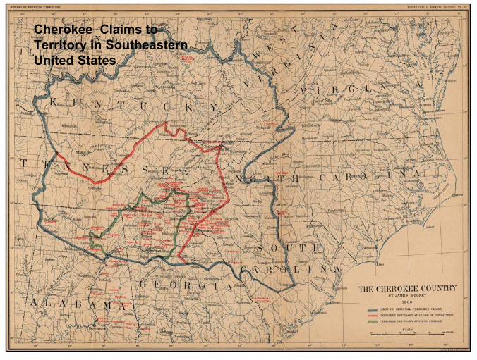
Cherokee Claims to Territory in Southeastern United States
79
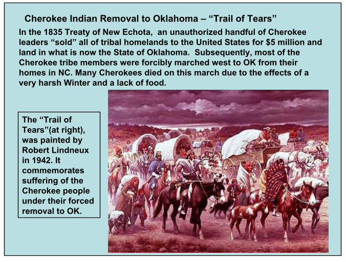
Cherokee Indian Removal to Oklahoma – “Trail of Tears”In the 1835 Treaty of New Echota, an unauthorized handful of Cherokee leaders “sold” all of tribal homelands to the United States for $5 million andland in what is now the State of Oklahoma. Subsequently, most of the Cherokee tribe members were forcibly marched west to OK from their homes in NC. Many Cherokees died on this march due to the effects of a very harsh Winter and a lack of food.
The “Trail of Tears”(at right), was painted by Robert Lindneuxin 1942. It commemorates suffering of the Cherokee people under their forced removal to OK.
80
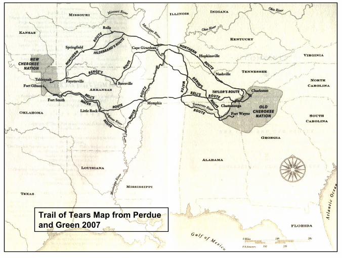
Trail of Tears Map from Perdue and Green 2007

81
Cherokee Winter House

82
Cherokee Summer House

83
Wolf Creek Cherokees of SW VA
Wolf Creek Indian Village and Museum near Bastian, Virginia.
The Wolf Creek Cherokee Tribe, Inc. is now located in Stuart, Virginia amid the Blue Ridge Mountains.
At one time, the Cherokee owned all of Southwestern Virginia. But, this land was sold through a series of treaties with the Colony and/or the State of Virginia.
The Cherokee hunted in this area, raided their enemies during different wars, and visited forts and trading posts in the area. In the Treaty with the Cherokee at Hard Labor, SC in October, 1768, the British government purchased most of the tribal holdings east of the New River.
Cherokee Indians from NC would hunt in SW Virginia during the Spring, Summer, and Fall and return to Cherokee, NC in the Winter.

84
The bird pictograph (at right) on Paint Lick Mountain (below) in Tazewell Co., Virginia may have been done by the Cherokee Indians who lived in the area. This example is probably of the mythical “Thunderbird” that was thought to be responsible for thunder, lightening and rain. The Thunderbird is a prominent icon seen throughout the Southeastern Ceremonial Complex (SCC) which included Cherokee ancestors.

85
Tutelo & Saponi (S)
Tutelo (also Totero, Totteroy, Tutera) was a Siouan tribe, closely related to the Monacan and Manahoac peoples, known to be living above the Fall Line in present-day Virginia by 1607. Under pressure from English settlers, they joined with the Saponi. In 1740, they left Virginia and migrated north to seek protection from the Iroquois, where they were adopted by the Cayuga tribe in New York
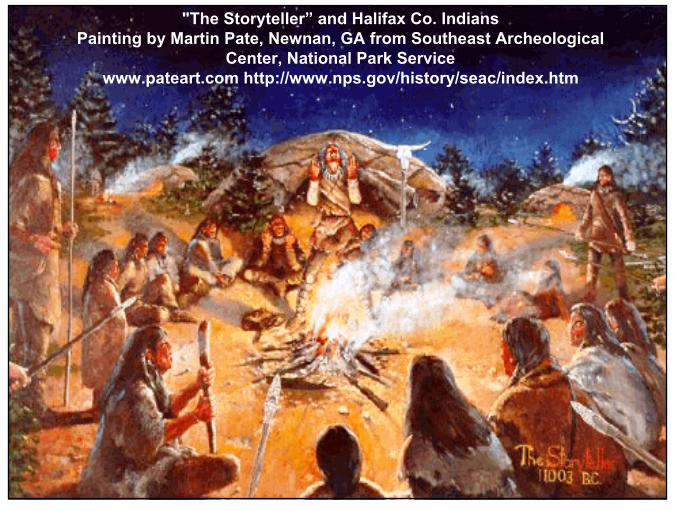
Saponi, is the name of one of the eastern Siouan tribes related to the Tutelo, Occaneechi, Monacan, Manahoac and other eastern Siouan peoples, whose ancestral homeland is in North Carolina and Virginia. The people known as the Indians of Person County were formally recognized by North Carolina in 1911 as an American Indian tribe. In 2003 they formally changed their name toSappony. The Haliwa-Saponi, a group based chiefly in Halifax County, is another Native American band formally recognized by North Carolina (1965). They also changed their name to include a reference to Saponi.
86
"The Storyteller” and Halifax Co. IndiansPainting by Martin Pate, Newnan, GA from Southeast Archeological
Center, National Park Servicewww.pateart.com http://www.nps.gov/history/seac/index.htm
87
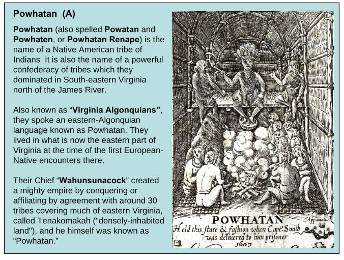
Powhatan (A)Powhatan (also spelled Powatan and Powhaten, or Powhatan Renape) is the name of a Native American tribe of Indians It is also the name of a powerful confederacy of tribes which they dominated in South-eastern Virginia north of the James River.
Also known as “Virginia Algonquians”, they spoke an eastern-Algonquian language known as Powhatan. They lived in what is now the eastern part of Virginia at the time of the first European-Native encounters there.
Their Chief “Wahunsunacock” created a mighty empire by conquering or affiliating by agreement with around 30 tribes covering much of eastern Virginia, called Tenakomakah ("densely-inhabited land"), and he himself was known as “Powhatan.”
88
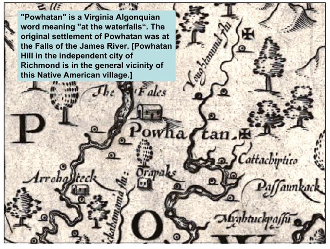
"Powhatan" is a Virginia Algonquian word meaning "at the waterfalls“. The original settlement of Powhatan was at the Falls of the James River. [Powhatan Hill in the independent city of Richmond is in the general vicinity of this Native American village.]
89
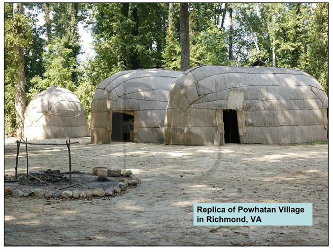
Replica of Powhatan Village in Richmond, VA
90
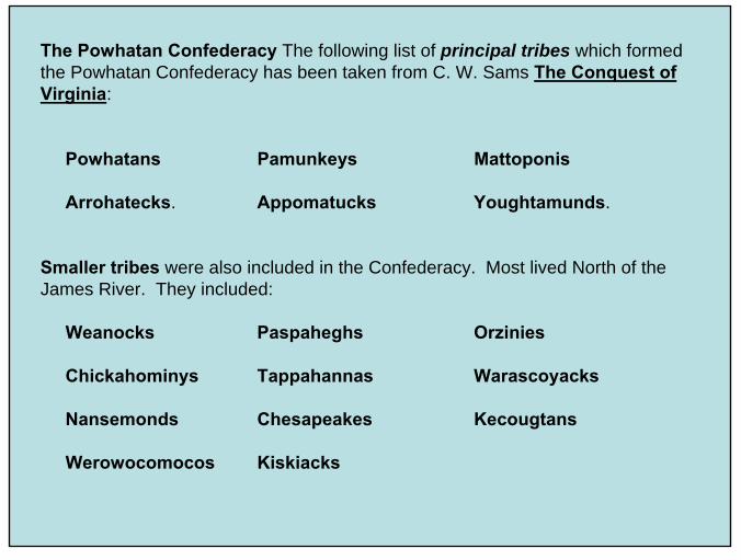
The Powhatan Confederacy The following list of principal tribes which formed the Powhatan Confederacy has been taken from C. W. Sams The Conquest of Virginia:
Powhatans Pamunkeys Mattoponis
Arrohatecks. Appomatucks Youghtamunds.
Smaller tribes were also included in the Confederacy. Most lived North of theJames River. They included:
Weanocks Paspaheghs Orzinies
Chickahominys Tappahannas Warascoyacks
Nansemonds Chesapeakes Kecougtans
Werowocomocos Kiskiacks

91
Powhatan Confederacy on John Smith’s Map of 1624

92
Map of the Principal Area Included in the Powhatan Confederacy (Sams –Conquest of Virginia pg. 142)

93
Besides the capital village of "Powhatan" in the Powhatan Hill section of the eastern part of the current city of Richmond, another capital of this confederacy about 75 miles (121 km) to the east was called Werowocomoco. It was located near the north bank of the York River in present-dayGloucester County, Virginia.
Werowocomoco was described by the English colonists as only 15 miles (24 km) as the crow flies from Jamestown. Substantial archaeological evidence discovered in the early 21st century now locates the site on Purtan Bay, about 12 air miles from Jamestown.
94
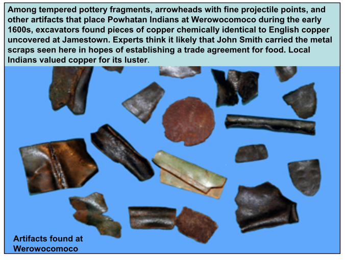
Among tempered pottery fragments, arrowheads with fine projectile points, and other artifacts that place Powhatan Indians at Werowocomoco during the early 1600s, excavators found pieces of copper chemically identical to English copper uncovered at Jamestown. Experts think it likely that John Smith carried the metal scraps seen here in hopes of establishing a trade agreement for food. Local Indians valued copper for its luster.
Artifacts found at Werowocomoco

95
Beginning in 1607, the encroachment of English settlers and their ever-growing numbers on what had been Indian lands resulted in conflicts whichbecame almost continuous for the next 39 years.
After Wahunsunacock's death in 1618, hostilities escalated under the chiefdom of his brother, Opechancanough(pictured at right) who sought in vain to drive the Europeans away, leading the Indian Massacre of 1622 and another in 1644. These attempts saw strong reprisals from the English, ultimately resulting in the near elimination of the tribe.
The Powhatan Confederacy was largely destroyed by 1646.

96
Opechancanough Lead Warriors in Major Uprisings Against Settlers in 1622 & again in 1644. He was captured & killed by a soldier assigned to guard him in 1646.

97
Maps by Helen Roundtree

98
Yuchi or Westo (Uchean)
Yuchi, which means "situated yonder at a distance," The Yuchi refer to themselves as "TSO-YA-HA," or "children of the sun.”
Their original residence in Tennessee, Georgia and Alabama is ancient. Their residence in SW Virginia was on the Great War Path Trail near Saltville, VA.
Classified as “Uchean”linguistic stock, the Yuchihave a distinct language unrelated to the Algonquian, Siouan, or Iroquoian languages used by most other Indians residing in VA.
99
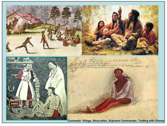
Clockwise: Village, Story-teller, Supreme Commander, Trading with Gomez

100
A Yuchi village on the North Fork of the Holston River (i.e., near Saltville, VA--circled) was attacked and decimated by Spanish Conquistadors fighting with Indian warriors from the village of Joara in NC under the command of Juan Pardo’s Sgt. Moyano in 1567.
Part of the Great Warrior’s Path on the Jefferson-FryMap of 1751
Yuchi warrior from a Confederate Bank Note

101
References:
Carr, Lucien, “Report on the Exploration of a Mound in Lee Co., VA Conducted for the Peabody Museum”, Vol.2, 1876-79, Reports of the Peabody Museum of American Archaeology and Ethnology, pgs 75-94 (1880)
Eckard, Chris, “Stone Tools and Archaeology of Virginia” [a web site at: http://www.geocities.com/CapeCanaveral/Galaxy/2863/index.html]
Egloff, Keith, and Woodward, Deborah, First People: The Early Indians of Virginia, Virginia State Department of Historic Resources, Univ. Press of Virginia (1992)
Gardner, William M., Lost Arrowheads & Broken Pottery: Traces of Indians in the Shenandoah Valley, Thunderbird Museum (1986)
Glanville, Jim, “Conquistadors at Saltville in 1567? A Review of the Archaeological and Documentary Evidence,” The Smithfield Review, Vol. VIII, pgs. 70-108 (2004)
Jefferson, Thomas, Notes on the State of Virginia, (1801)
Johnson-Humrickhouse Museum, “Old Questions, New Science: Reinterpreting Native American Origins in Light of Modern Methods and Technology (A Public Symposium)”, Coshocton, Ohio(4/25/2009)
McAvoy, Joseph, “Discusses Cactus Hill Site” at [http://ngm.nationalgeographic.com/ngm/0012/feature3/index.html]
McDonald, Jerry N., “An Outline of the Pre-Clovis Archeology of SV-2, Saltville, Virginia, with Special Attention to a Bone Tool Dated 14,510 yr BP”, Jeffersoniana No. 9, 11/30/2000, VA Museum of Natural History
Myers, Maureen, “Excavations at the Mississippian Edge: Results of 2007 and 2008 Fieldwork at the Carter Robinson Site (44LE10), Lee Co., VA”, Arch. Society of Virginia, 66th Annual Mtg, 10/9-12/2008

102
References Cont.
Ohio Historical Society at [http://ohio-archaeology.blogspot.com/2009_01_01_archive.html]
Peck, Rodney M, America’s Largest Paleo-Indian Workshop Site, Dinwiddie Co., VA: The Williamson Site(1984); and, Eastern Fluted Points (1998)
Perdue, Theda and Green, Michael D., The Cherokee Nation and the Trail of Tears, Penguin Group, Ny, NY 2009
Potter, Stephen R., Commoners, Tribute, and Chiefs: The Development of Algonquian Culture in the Potomac Valley, Univ. Press of VA, Charlottesville, VA (1993)
Rountree, Helen C. The Powhatan Indians of Virginia: Their Traditional Culture, Univ. of OK Press
Sams, C. W., Conquest of Virginia: The Forest Primeval, G. P. Putnam’s Sons, NY and London (1916)
Tanner, Helen Hornbeck, The Settling of North America, Macmillan, NY, NY (1997)
Thomas, Cyrus “Cherokees Probably Mound-Builders” in Mag. Of Am. History, Vol. XI, Jan-June 1884, pgs. 396-407
Waselkov, G.A., Wood, P.H. and Hatley, T., Powhatan’s Mantle: Indians in the Colonial SE, Univ. of NE Press, 2006
Whittaker, John C., Flintknapping: Making & Understanding Stone Tools, Univ. of Texas Press (1994)
Wikipedia (the Free Encyclopedia) at www.wikipedia.com