indoor multi-dimensional location gml and its application ...information. indoor location...
TRANSCRIPT
International Journal of
Geo-Information
Article
Indoor Multi-Dimensional Location GML and ItsApplication for Ubiquitous Indoor Location Services
Qing Zhu 1,2,3,4,*, Yun Li 1, Qing Xiong 3,4, Sisi Zlatanova 5, Yulin Ding 1, Yeting Zhang 3,4
and Yan Zhou 6
1 Faculty of Geosciences and Environmental Engineering of Southwest Jiaotong University, 999 Xi’an Road,Chengdu 611756, China; [email protected] (Y.L.); [email protected] (Y.D.)
2 State-Province Joint Engineering Laboratory of Spatial Information Technology for High-Speed RailwaySafety, 999 Xi’an Road, Chengdu 611756, China
3 Collaborative Innovation Center for Geospatial Technology, 129 Luoyu Road, Wuhan 430072, China;[email protected] (Q.X.); [email protected] (Y.Z.)
4 State Key Laboratory of Information Engineering in Surveying Mapping and Remote Sensing,Wuhan University, 129 Luoyu Road, Wuhan 430072, China
5 3D Geoinformation, Urbanism, Delft University of Technology, Julianalaan 134, 2628 BL Delft,The Netherlands; [email protected]
6 School of Resources and Environment, University of Electric Science and Technology of China,2006 Xiyuan Avenue, West Hi-tech Zone, Chengdu 611731, China; [email protected]
* Correspondence: [email protected]; Tel.: +86-137-0908-0727
Academic Editor: Wolfgang KainzReceived: 18 August 2016; Accepted: 24 November 2016; Published: 29 November 2016
Abstract: The Open Geospatial Consortium (OGC) Geography Markup Language (GML) standardprovides basic types and a framework for defining geo-informational data models such as CityGMLand IndoorGML, which provide standard information models for 3D city modelling and lightweightindoor network navigation. Location information, which is the semantic engine that fuses biggeo-information data, is however, discarded in these standards. The Chinese national standard ofIndoor Multi-Dimensional Location GML (IndoorLocationGML) presented in this study can be usedin ubiquitous indoor location intelligent applications for people and robots. IndoorLocationGMLis intended as an indoor multi-dimensional location information model and exchange data formatstandard, mainly for indoor positioning and navigation. This paper introduces the standard’s mainfeatures: (1) terminology; (2) indoor location information model using a Unified Modeling Language(UML) class diagram; (3) indoor location information markup language based on GML; and (4) usecases. A typical application of the standard is then discussed. This standard is applicable to theexpression, storage, and distribution of indoor multi-dimensional location information, and to theseamless integration of indoor–outdoor location information. The reference and basis are thereforerelevant to publishers, managers, users, and developers of indoor navigation and location-basedservices (LBS).
Keywords: indoor location; location-based service; standard; navigation
1. Defining IndoorLocationGML
The technology of navigation and positioning services is vital for national security, economicdevelopment, and livelihood. It supports the Internet of Things (IoT), Smart Earth, and disastermitigation and relief through the supply of fundamental information models, infrastructures,and services. The requirements for highly accurate indoor–outdoor seamless navigation andpositioning services are rapidly growing as the use of smart portable devices and mobile Internetincreases. The indoor environment differs from the outdoors in many aspects. By default the
ISPRS Int. J. Geo-Inf. 2016, 5, 220; doi:10.3390/ijgi5120220 www.mdpi.com/journal/ijgi

ISPRS Int. J. Geo-Inf. 2016, 5, 220 2 of 21
outdoor spatial information is handled by traditional geographic information science, which needsvarious adaptations for indoor environments. The third dimension is a major factor in indoor spatialinformation, as the environment consists of multiple surfaces, whereas the outdoors can be representedby one common surface. Unlike the outdoors, indoor spaces are closed, narrow, private, and haveobstacles, hidden objects, and no global positioning system (GPS satellite signals do not reachindoors) [1]. The basic concepts, data models, and standards for outdoor information are therefore notsuitable [2,3], but end-users still require seamless, useful, and reliable indoor information.
The International Organization for Standardization (ISO), the OGC, and many nationalstandards throughout the world focus on standardising spatial information and models that supportgeo-information-related applications. The OGC has established three standards relevant to our study.The first, the OpenGIS Geography Markup Language (GML) Encoding Standard absorbed manyprevious ISO standards and provides ubiquitous geographical models [4]. The second, the OGC CityGeography Markup Language (CityGML) Encoding Standard, based on GML, defines a multiresolutionthree-dimensional model containing geometrical information, semantics, topology, and the appearanceof artificial structures in urban or regional contexts. This standard can be used for advanced analysisand visualisation, and supports applications such as indoor–outdoor navigation [5]. The Levels-ofDetail (LOD) 4 of CityGML defines very detailed indoor objects, which can be used to supportindoor-related applications. The third, the IndoorGML standard, focuses on representing the propertiesand connectivity of indoor space and providing spatial feature references, instead of representingarchitectural components [3].
Several 3D building modelling standards such as CityGML, Keyhole Markup Language (KLM),and Industry Foundation Classes (IFC) deal with the interior space of building from geometric,cartographic, and semantic points of view. Even the most relevant standard, IndoorGML, only focuseson modelling indoor space for lightweight navigation purposes, required for the components ofnavigation networks. These existing standards lack the means to express the most basic indoor locationinformation. Indoor location information constitutes the semantic engine that integrates big data,aggregates resources, fuses information, and produces values, and is an important considerationin the context of emergency response [6,7]. Typical use cases of indoor location information areindoor map representation, e.g., [8–10], navigation for humans and robots, e.g., [11–14], and indoorfacility management. To enable people and robots to be more aware of the indoor environment,indoor multi-dimensional location models have been developed and their potential applicationsinvestigated [15–17], but the existing indoor location description models only provide basic absoluteand relative location concepts; they are lacking rigorous sematic relationship description, which limitstheir broader user-oriented applications. Several Chinese positioning systems have recently beendeveloped, including the Beidou Xihe system, which provides seamless indoor–outdoor and real-timepositioning services but no means of relative localisation. The standardisation of indoor locationinformation is therefore required. The Chinese national standard Indoor Multi-Dimensional LocationGML (IndoorLocationGML) has recently been initiated, aimed at facilitating the development ofubiquitous indoor location intelligent applications for both people and robots. The goal is to createan indoor multi-dimensional location information model and exchange data format standard forindoor positioning and navigation. Details of the main concepts, models, definitions, and applicationof IndoorLocationGML are discussed in this paper.
2. Description Model of Multi-Dimensional Indoor Location Information
The indoor multi-dimensional location information model is the basis of indoor navigation andlocation-based services and the foundation of indoor map expression. It defines the components oflocation information, and describes a multi-dimensional location model based on space and event.It covers relevant definitions and supports indoor location-based applications.

ISPRS Int. J. Geo-Inf. 2016, 5, 220 3 of 21
2.1. Terminology
Terms and definitions used in the standard are listed in Table 1.
Table 1. Terminology of IndoorLocationGML.
Terminology Description
Indoor location A location of an object in indoor and enclosed spaces.
Indoor absolute locationA unitary structured description and identification of an indoor objectin indoor space. It is only relevant to the spatial reference system inwhich it is defined.
Indoor relative location A structured description and identification of the indoor object byspatial relationship between the indoor object and other references.
Indoor spatial reference systemA spatial coordinate reference system of the indoor space. It isassociated with an indoor reference and an indoor target. It can begeographic coordinate systems or local Cartesian coordinate system.
Indoor spatial relationshipThe relationship between any two or more target objects in indoorspace. It includes: directional relationship, distance relationship,order relationship, and topology relationship.
Multi-dimensional location The information used to describe indoor absolute location and indoorrelative location from the perspective of space, time, and semantics.
2.2. Indoor Location Information Model Using UML Diagram
The indoor location information model in the IndoorLocationGML standard is shown in Figure 1,using the UML class diagram.
ISPRS Int. J. Geo-Inf. 2016, 5, 220 3 of 19
ISPRS Int. J. Geo-Inf. 2016, 5, x; doi: FOR PEER REVIEW www.mdpi.com/journal/ijgi
Table 1. Terminology of IndoorLocationGML.
Terminology DescriptionIndoor location A location of an object in indoor and enclosed spaces.
Indoor absolute location
A unitary structured description and identification of an indoor object in indoor space. It is only relevant to the spatial reference system in which it is defined.
Indoor relative location
A structured description and identification of the indoor object by spatial relationship between the indoor object and other references.
Indoor spatial reference system
A spatial coordinate reference system of the indoor space. It is associated with an indoor reference and an indoor target. It can be geographic coordinate systems or local Cartesian coordinate system.
Indoor spatial relationship
The relationship between any two or more target objects in indoor space. It includes: directional relationship, distance relationship, order relationship, and topology relationship.
Multi-dimensional location
The information used to describe indoor absolute location and indoor relative location from the perspective of space, time, and semantics.
2.2. Indoor Location Information Model Using UML Diagram
The indoor location information model in the IndoorLocationGML standard is shown in Figure 1, using the UML class diagram.
Figure 1. UML diagram of indoor multi-dimensional location information.
This model follows the conventions of the UML schema of GML 3.2.1, and many of the types are directly or indirectly inherited from GML types.
Figure 1. UML diagram of indoor multi-dimensional location information.
This model follows the conventions of the UML schema of GML 3.2.1, and many of the types aredirectly or indirectly inherited from GML types.

ISPRS Int. J. Geo-Inf. 2016, 5, 220 4 of 21
AbstractIndoorLocation is defined as an abstract class in this model. Two classes, indoor absolutelocation and indoor relative location, are subclasses of this abstract class. AbstractIndoorLocation classhas three basic attributes:
1. life: Represents the timeliness of indoor locations.2. trs: Represents the temporal characteristic of indoor locations.3. crs: Represents the local coordinate reference system of indoor locations. The coordinate reference
system used in indoor geometrical location measurement should be the three-dimensionalCartesian coordinate system.
IndoorAbsoluteLocation is a specialisation of AbstractIndoorLocation representing an indoorlocation that is non-changeable. It is described by a geometrical coordinate in the given coordinatereference system.
IndoorRelativeLocation is another specialisation of AbstractIndoorLocation. To describea relative location, at least one reference location must be specified. To specify a reference location,the existing absolute location can be used. It is composed of:
1. Relative Geometrical Location: Described by values of distance and direction (horizontal andvertical angles) relative to a reference object.
2. Relative Semantic Location: Described by semantics such as direction description (e.g., up,down, left, right, front, back), distance description (including a numerical value of distance anda semantic description such as: “Two meters away from the reference object“), order description(previous and next), and topology description (contain, adjacency and connectivity) relative toone or more reference object(s).
2.3. Indoor Location Information Markup Language Using GML
The XML schema for the Indoor Location Information data model is defined as an applicationschema of GML. The rules defined in GML3.2.1 is complied with when mapping from UML schema toXML Schema.
2.3.1. IndoorLocation
<AbstractIndoorLocationType> is an abstract class inherited from gml:AbstractFeatureType; it actas the base class for classes that represent indoor locations. Its content model contains three elementproperties for attaching a temporal reference system and a spatial reference system and specifying thelife cycle to an indoor location object. <IndoorLocation> is a root element of IndoorLocationGML. It isaggregated with IndoorAbsoluteLocation and IndoorRelativeLocation.
ISPRS Int. J. Geo-Inf. 2016, 5, 220 4 of 19
ISPRS Int. J. Geo-Inf. 2016, 5, x; doi: FOR PEER REVIEW www.mdpi.com/journal/ijgi
AbstractIndoorLocation is defined as an abstract class in this model. Two classes, indoor absolute location and indoor relative location, are subclasses of this abstract class. AbstractIndoorLocation class has three basic attributes:
1. life: Represents the timeliness of indoor locations. 2. trs: Represents the temporal characteristic of indoor locations. 3. crs: Represents the local coordinate reference system of indoor locations. The coordinate
reference system used in indoor geometrical location measurement should be the three-dimensional Cartesian coordinate system.
IndoorAbsoluteLocation is a specialisation of AbstractIndoorLocation representing an indoor location that is non-changeable. It is described by a geometrical coordinate in the given coordinate reference system.
IndoorRelativeLocation is another specialisation of AbstractIndoorLocation. To describe a relative location, at least one reference location must be specified. To specify a reference location, the existing absolute location can be used. It is composed of:
1. Relative Geometrical Location: Described by values of distance and direction (horizontal and vertical angles) relative to a reference object.
2. Relative Semantic Location: Described by semantics such as direction description (e.g., up, down, left, right, front, back), distance description (including a numerical value of distance and a semantic description such as: “Two meters away from the reference object“), order description (previous and next), and topology description (contain, adjacency and connectivity) relative to one or more reference object(s).
2.3. Indoor Location Information Markup Language Using GML
The XML schema for the Indoor Location Information data model is defined as an application schema of GML. The rules defined in GML3.2.1 is complied with when mapping from UML schema to XML Schema.
2.3.1. IndoorLocation
<AbstractIndoorLocationType> is an abstract class inherited from gml:AbstractFeatureType; it act as the base class for classes that represent indoor locations. Its content model contains three element properties for attaching a temporal reference system and a spatial reference system and specifying the life cycle to an indoor location object. <IndoorLocation> is a root element of IndoorLocationGML. It is aggregated with IndoorAbsoluteLocation and IndoorRelativeLocation.
<!-- ====================================================================== --> <xs:complexType name="AbstractIndoorLocationType" abstract="true">
<xs:complexContent> <xs:extension base="gml: AbstractFeatureType">
<xs:sequence> <xs:element name="life" type="gml:TimePeriodPropertyType"/> <xs:element name="trs" type="gml:TemporalCRSType"/> <xs:element name="crs" type="SpatialReferenceSystemType" />
</xs:sequence> </xs:extension>
</xs:complexContent> </xs:complexType> <!-- ====================================================================== --> <xs:element name="IndoorLocation" type="IndoorLocationType" substitutionGroup="gml:AbstractFeature"/> <!-- ====================================================================== --> <xs:complexType name="IndoorLocationType">
<xs:complexContent> <xs:extension base="gml: AbstractFeatureType">
<xs:sequence> <xs:element name="absoluteLocation" type="IndoorAbsoluteLocationPropertyType" minOccurs="0" maxOccurs="unbounded"/>

ISPRS Int. J. Geo-Inf. 2016, 5, 220 5 of 21
ISPRS Int. J. Geo-Inf. 2016, 5, 220 5 of 19
ISPRS Int. J. Geo-Inf. 2016, 5, x; doi: FOR PEER REVIEW www.mdpi.com/journal/ijgi
<xs:element name="relativeLocation" type="IndoorRelativeLocationPropertyType" minOccurs="0" maxOccurs="unbounded"/>
</xs:sequence> </xs:extension>
</xs:complexContent> </xs:complexType> <!-- ====================================================================== --> <xs:complexType name="SpatialReferenceSystemType">
<xs:complexContent> <xs:extension base="gml: AbstractCRSType">
<xs:choice> <xs:element ref="gml:EngineeringCRS" minOccurs="0" maxOccurs="1"/> <xs:element ref="gml:GeodeticCRS" minOccurs="0" maxOccurs="1"/>
</xs:choice> </xs:extension>
</xs:complexContent> </xs:complexType>
2.3.2. IndoorAbsoluteLocation
<IndoorAbsoluteLocation> is an element representing an absolute location in indoor space (enclosed space), and is derived from the class <AbstractIndoorLocation>. It contains a “coordinate”, which is GeometricalCoordinateType type. GeometricalCoordinateType contains a coordinate element which is of type gml:DirectPositionType. gml:DirectPositionType has two abbributes, srsName and srsDimension. The former one is optional and can be used to refer to an existing coordinate reference system, and the latter one can be used to specify the dimension of a point.
<!-- ====================================================================== --> <xs:element name="IndoorAbsoluteLocation" type="IndoorAbsoluteLocationType" substitutionGroup="gml:AbstractFeature"/> <!-- ====================================================================== --> <xs:complexType name=" IndoorAbsoluteLocationPropertyType">
<xs:sequence> <xs:element ref="IndoorAbsoluteLocation" minOccurs="0" maxOccurs="unbounded"/>
<xs:sequence> <xs:attributeGroup ref="gml:AggregationAttributeGroup"/>
</xs:complexType> <!-- ====================================================================== --> <xs:complexType name=" IndoorAbsoluteLocationType">
<xs:complexContent> <xs:extension base="AbstractIndoorLocationType">
<xs:sequence> <xs:element name="coordinate" type="GeometricCoordinateType" minOccurs="1" maxOccurs="1"/>
</xs:sequence> </xs:extension>
</xs:complexContent> </xs:complexType> <xs:complexType name="GeometricCoordinateType">
<xs:sequence> <xs:element name="crs" type="SpatialReferenceSystemType" minOccurs="0" maxOccurs="1"/> <xs:sequence minOccurs="1" maxOccurs="1">
<xs:element name="coordinate" type="gml:DirectPositionType"/> </xs:sequence>
</xs:sequence> </xs:complexType>
2.3.3. IndoorRelativeLocation
<IndoorRelativeLocation> is an element representing a location in indoor space relative to a specified reference object. Its content model contains two properties describing a relative location from geometrical and semantic perspectives.
2.3.2. IndoorAbsoluteLocation
<IndoorAbsoluteLocation> is an element representing an absolute location in indoor space(enclosed space), and is derived from the class <AbstractIndoorLocation>. It contains a “coordinate”,which is GeometricalCoordinateType type. GeometricalCoordinateType contains a coordinate elementwhich is of type gml:DirectPositionType. gml:DirectPositionType has two abbributes, srsName andsrsDimension. The former one is optional and can be used to refer to an existing coordinate referencesystem, and the latter one can be used to specify the dimension of a point.
ISPRS Int. J. Geo-Inf. 2016, 5, 220 5 of 19
ISPRS Int. J. Geo-Inf. 2016, 5, x; doi: FOR PEER REVIEW www.mdpi.com/journal/ijgi
<xs:element name="relativeLocation" type="IndoorRelativeLocationPropertyType" minOccurs="0" maxOccurs="unbounded"/>
</xs:sequence> </xs:extension>
</xs:complexContent> </xs:complexType> <!-- ====================================================================== --> <xs:complexType name="SpatialReferenceSystemType">
<xs:complexContent> <xs:extension base="gml: AbstractCRSType">
<xs:choice> <xs:element ref="gml:EngineeringCRS" minOccurs="0" maxOccurs="1"/> <xs:element ref="gml:GeodeticCRS" minOccurs="0" maxOccurs="1"/>
</xs:choice> </xs:extension>
</xs:complexContent> </xs:complexType>
2.3.2. IndoorAbsoluteLocation
<IndoorAbsoluteLocation> is an element representing an absolute location in indoor space (enclosed space), and is derived from the class <AbstractIndoorLocation>. It contains a “coordinate”, which is GeometricalCoordinateType type. GeometricalCoordinateType contains a coordinate element which is of type gml:DirectPositionType. gml:DirectPositionType has two abbributes, srsName and srsDimension. The former one is optional and can be used to refer to an existing coordinate reference system, and the latter one can be used to specify the dimension of a point.
<!-- ====================================================================== --> <xs:element name="IndoorAbsoluteLocation" type="IndoorAbsoluteLocationType" substitutionGroup="gml:AbstractFeature"/> <!-- ====================================================================== --> <xs:complexType name=" IndoorAbsoluteLocationPropertyType">
<xs:sequence> <xs:element ref="IndoorAbsoluteLocation" minOccurs="0" maxOccurs="unbounded"/>
<xs:sequence> <xs:attributeGroup ref="gml:AggregationAttributeGroup"/>
</xs:complexType> <!-- ====================================================================== --> <xs:complexType name=" IndoorAbsoluteLocationType">
<xs:complexContent> <xs:extension base="AbstractIndoorLocationType">
<xs:sequence> <xs:element name="coordinate" type="GeometricCoordinateType" minOccurs="1" maxOccurs="1"/>
</xs:sequence> </xs:extension>
</xs:complexContent> </xs:complexType> <xs:complexType name="GeometricCoordinateType">
<xs:sequence> <xs:element name="crs" type="SpatialReferenceSystemType" minOccurs="0" maxOccurs="1"/> <xs:sequence minOccurs="1" maxOccurs="1">
<xs:element name="coordinate" type="gml:DirectPositionType"/> </xs:sequence>
</xs:sequence> </xs:complexType>
2.3.3. IndoorRelativeLocation
<IndoorRelativeLocation> is an element representing a location in indoor space relative to a specified reference object. Its content model contains two properties describing a relative location from geometrical and semantic perspectives.
2.3.3. IndoorRelativeLocation
<IndoorRelativeLocation> is an element representing a location in indoor space relative toa specified reference object. Its content model contains two properties describing a relative locationfrom geometrical and semantic perspectives.

ISPRS Int. J. Geo-Inf. 2016, 5, 220 6 of 21
ISPRS Int. J. Geo-Inf. 2016, 5, 220 6 of 19
ISPRS Int. J. Geo-Inf. 2016, 5, x; doi: FOR PEER REVIEW www.mdpi.com/journal/ijgi
<!-- ====================================================================== --> <xs:element name="IndoorRelativeLocation" type=" IndoorRelativeLocationType" substitutionGroup="gml:AbstractFeature"/> <!-- ====================================================================== --> <xs:complexType name=" IndoorRelativeLocationPropertyType">
<xs:sequence> <xs:element ref=" IndoorRelativeLocation" minOccurs="0" maxOccurs="unbounded"/>
<xs:sequence> <xs:attributeGroup ref="gml:AggregationAttributeGroup"/>
</xs:complexType> <!-- ====================================================================== --> <xs:complexType name=" IndoorRelativeLocationType ">
<xs:complexContent> <xs:extension base="AbstractIndoorLocationType">
<xs:sequence> <xs:element name="geometricLocation" type="RelativeGeometricLocationPropertyType" minOccurs="1" maxOccurs="1"/> <xs:element name="semanticLocation" type="SemanticLocationPropertyType" minOccurs="1" maxOccurs="1"/>
</xs:sequence> </xs:extension>
</xs:complexContent> </xs:complexType>
2.3.4. RelativeGeometricalLocation
<RelativeGeometricalLocation> is an element used to represent the geometrical part of a relative location. It is an aggregation of a list of geometrical location descriptions, each of which is described by the distance from and the horizontal and vertical angle to a reference object.
<!-- ====================================================================== --> <xs:element name="RelativeGeometricLocation" type=" RelativeGeometricLocationType" substitutionGroup="gml:AbstractFeature"/> <!-- ====================================================================== --> <xs:complexType name=" RelativeGeometricLocationPropertyType">
<xs:sequence> <xs:element ref=" RelativeGeometricLocation" minOccurs="1" maxOccurs="1"/>
<xs:sequence> <xs:attributeGroup ref="gml:AggregationAttributeGroup"/>
</xs:complexType> <!-- ====================================================================== --> <xs:complexType name=" RelativeGeometricLocationType">
<xs:complexContent> <xs:extension base="gml:AbstractFeatureType">
<xs:sequence> <xs:element name="geometricDescription" type=" GeometricLocationDescriptionPropertyType" minOccurs="1" maxOccurs="unbounded"/>
</xs:sequence> </xs:extension>
</xs:complexContent> </xs:complexType> <!-- ====================================================================== --> <xs:element name=" GeometricLocationDescription" type=" GeometricLocationDescriptionType" substitutionGroup="gml:AbstractFeature"/> <!-- ====================================================================== --> <xs:complexType name=" GeometricLocationDescriptionPropertyType">
<xs:sequence> <xs:element ref=" GeometricLocationDescription" minOccurs="1" maxOccurs="unbounded"/>
<xs:sequence> <xs:attributeGroup ref="gml:AggregationAttributeGroup"/>
</xs:complexType> <!-- ====================================================================== --> <xs:complexType name=" GeometricLocationDescriptionType">
<xs:complexContent> <xs:extension base="gml:AbstractFeatureType">
<xs:sequence> <xs:element name="reference" type="ReferenceObjectPropertyType"/>
2.3.4. RelativeGeometricalLocation
<RelativeGeometricalLocation> is an element used to represent the geometrical part of a relativelocation. It is an aggregation of a list of geometrical location descriptions, each of which is describedby the distance from and the horizontal and vertical angle to a reference object.
ISPRS Int. J. Geo-Inf. 2016, 5, 220 6 of 19
ISPRS Int. J. Geo-Inf. 2016, 5, x; doi: FOR PEER REVIEW www.mdpi.com/journal/ijgi
<!-- ====================================================================== --> <xs:element name="IndoorRelativeLocation" type=" IndoorRelativeLocationType" substitutionGroup="gml:AbstractFeature"/> <!-- ====================================================================== --> <xs:complexType name=" IndoorRelativeLocationPropertyType">
<xs:sequence> <xs:element ref=" IndoorRelativeLocation" minOccurs="0" maxOccurs="unbounded"/>
<xs:sequence> <xs:attributeGroup ref="gml:AggregationAttributeGroup"/>
</xs:complexType> <!-- ====================================================================== --> <xs:complexType name=" IndoorRelativeLocationType ">
<xs:complexContent> <xs:extension base="AbstractIndoorLocationType">
<xs:sequence> <xs:element name="geometricLocation" type="RelativeGeometricLocationPropertyType" minOccurs="1" maxOccurs="1"/> <xs:element name="semanticLocation" type="SemanticLocationPropertyType" minOccurs="1" maxOccurs="1"/>
</xs:sequence> </xs:extension>
</xs:complexContent> </xs:complexType>
2.3.4. RelativeGeometricalLocation
<RelativeGeometricalLocation> is an element used to represent the geometrical part of a relative location. It is an aggregation of a list of geometrical location descriptions, each of which is described by the distance from and the horizontal and vertical angle to a reference object.
<!-- ====================================================================== --> <xs:element name="RelativeGeometricLocation" type=" RelativeGeometricLocationType" substitutionGroup="gml:AbstractFeature"/> <!-- ====================================================================== --> <xs:complexType name=" RelativeGeometricLocationPropertyType">
<xs:sequence> <xs:element ref=" RelativeGeometricLocation" minOccurs="1" maxOccurs="1"/>
<xs:sequence> <xs:attributeGroup ref="gml:AggregationAttributeGroup"/>
</xs:complexType> <!-- ====================================================================== --> <xs:complexType name=" RelativeGeometricLocationType">
<xs:complexContent> <xs:extension base="gml:AbstractFeatureType">
<xs:sequence> <xs:element name="geometricDescription" type=" GeometricLocationDescriptionPropertyType" minOccurs="1" maxOccurs="unbounded"/>
</xs:sequence> </xs:extension>
</xs:complexContent> </xs:complexType> <!-- ====================================================================== --> <xs:element name=" GeometricLocationDescription" type=" GeometricLocationDescriptionType" substitutionGroup="gml:AbstractFeature"/> <!-- ====================================================================== --> <xs:complexType name=" GeometricLocationDescriptionPropertyType">
<xs:sequence> <xs:element ref=" GeometricLocationDescription" minOccurs="1" maxOccurs="unbounded"/>
<xs:sequence> <xs:attributeGroup ref="gml:AggregationAttributeGroup"/>
</xs:complexType> <!-- ====================================================================== --> <xs:complexType name=" GeometricLocationDescriptionType">
<xs:complexContent> <xs:extension base="gml:AbstractFeatureType">
<xs:sequence> <xs:element name="reference" type="ReferenceObjectPropertyType"/>

ISPRS Int. J. Geo-Inf. 2016, 5, 220 7 of 21
ISPRS Int. J. Geo-Inf. 2016, 5, 220 7 of 19
ISPRS Int. J. Geo-Inf. 2016, 5, x; doi: FOR PEER REVIEW www.mdpi.com/journal/ijgi
<xs:element name=" direction" type=" ValueOfDirectionType"/> <xs:element name=" distance" type=" gml:LengthType"/>
</xs:sequence> </xs:extension>
</xs:complexContent> </xs:complexType> <!-- ====================================================================== --> <xs:complexType name="ValueOfDirectionType"> <xs:sequence> <xs:element name=" horizontalAngle" type="HorizontalAngleType" minOccurs="0" maxOccurs="1" /> <xs:element name=" verticalAngle" type="VerticalAngleType" minOccurs="0" maxOccurs="1"/> </xs:sequence> </xs:complexType> <!-- ====================================================================== --> <xs:complexType name="DirectionType"> <xs:sequence> <xs:element name=" Degree" type="DegreeType" /> <xs:element name=" ReferenceDirection" type="xs:string" /> </xs:sequence> </xs:complexType> <!-- ====================================================================== --> <xs:complexType name="HorizontalAngleType"> <complexContent> <xs:restriction base="DirectionType"> <xs:sequence> <xs:element name=" Degree" type=" gml:AngleType" /> <xs:element name=" ReferenceDirection" type="xs:string" fixed="North" /> </xs:sequence> </xs:restriction> </xs:complexContent> </xs:complexType> <!-- ====================================================================== --> <xs:complexType name="VerticalAngleType"> <xs:complexContent> <xs:restriction base="DirectionType"> <xs:sequence> <xs:element name=" Degree" type=" gml:AngleType" /> <xs:element name=" ReferenceDirection" type="xs:string" fixed="Up" /> </xs:sequence> </xs:restriction> </xs:complexContent> </xs:complexType>
2.3.5. SemanticLocation
<SemanticLocation> is an element used to represent the semantic part of a relative location. It includes:
1. The floor property is an xs:int number representing the floor the location object is on. 2. The function property is used to describe the function of the location object, and is defined as
gml:CodeType type. 3. The name property is an xs:string representing the name of an indoor location. 4. The roomNumber is an xs:string that is restricted to a string of combination of digits and letters. 5. The semanticDescription is SemanticLocationDescription type; it is composed of several
semantics to describe a location relative to a reference object, which are:
a. directionDescription, which is DirectionDescriptionType type, and is a list of enumeration values of strings to describe direction relative to the reference such as UP, DOWN, LEFT, RIGHT, FRONT, and BACK.
b. distanceDescription is described by a gml:description type and a gml:LengthType. The former is described semantically and the latter is an xs:double value with a gml:uom attached.
c. orderDescription uses NEXT and PREVIOUS to describe the sequential relative location to the reference object.
2.3.5. SemanticLocation
<SemanticLocation> is an element used to represent the semantic part of a relative location.It includes:
1. The floor property is an xs:int number representing the floor the location object is on.2. The function property is used to describe the function of the location object, and is defined as
gml:CodeType type.3. The name property is an xs:string representing the name of an indoor location.4. The roomNumber is an xs:string that is restricted to a string of combination of digits and letters.5. The semanticDescription is SemanticLocationDescription type; it is composed of several semantics
to describe a location relative to a reference object, which are:
a. directionDescription, which is DirectionDescriptionType type, and is a list of enumerationvalues of strings to describe direction relative to the reference such as UP, DOWN, LEFT,RIGHT, FRONT, and BACK.
b. distanceDescription is described by a gml:description type and a gml:LengthType. The formeris described semantically and the latter is an xs:double value with a gml:uom attached.
c. orderDescription uses NEXT and PREVIOUS to describe the sequential relative location tothe reference object.

ISPRS Int. J. Geo-Inf. 2016, 5, 220 8 of 21
d. topologyDescription uses CONTAIN, ADJACENCY, and CONNECTIVITY to describe thetopology relationships of a location to the reference object.
ISPRS Int. J. Geo-Inf. 2016, 5, 220 8 of 19
ISPRS Int. J. Geo-Inf. 2016, 5, x; doi: FOR PEER REVIEW www.mdpi.com/journal/ijgi
d. topologyDescription uses CONTAIN, ADJACENCY, and CONNECTIVITY to describe the topology relationships of a location to the reference object.
<!-- ====================================================================== --> <xs:element name="SemanticLocation" type="SemanticLocationType" substitutionGroup="gml:AbstractFeature"/> <!-- ====================================================================== --> <xs:complexType name="SemanticLocationPropertyType">
<xs:sequence> <xs:element ref="SemanticLocation" minOccurs="1" maxOccurs="1"/>
<xs:sequence> <xs:attributeGroup ref="gml:AggregationAttributeGroup"/>
</xs:complexType> <!-- ====================================================================== --> <xs:complexType name="SemanticLocationType">
<xs:complexContent> <xs:extension base="gml:AbstractFeatureType">
<xs:sequence> <xs:element name="semanticLocation" type="SemanticLocationDescriptionPropertyType"/> <xs:element name="floor" type="xs:int"> <xs:element name="function" type="gml:CodeType"> <xs:element name="name" type="xs:string"> <xs:element name="roomNumber">
<xs:simpleType> <xs:restriction base="xs:string">
<xs:pattern value="[a-zA-Z0-9]{0,255}$"/> </xs:restriction>
</xs:simpleType> </xs:element>
</xs:sequence> </xs:extension>
</xs:complexContent> </xs:complexType> <!-- ====================================================================== --> <xs:element name="SemanticLocationDescription" type="SemanticLocationDescriptionType" substitutionGroup="gml:AbstractFeature"/> <!-- ====================================================================== --> <xs:complexType name="SemanticLocationDescriptionPropertyType">
<xs:sequence> <xs:element ref="SemanticLocationDescription" minOccurs="1" maxOccurs="unbounded"/>
<xs:sequence> <xs:attributeGroup ref="gml:AggregationAttributeGroup"/>
</xs:complexType> <!-- ====================================================================== --> <xs:complexType name="SemanticLocationDescriptionType">
<xs:complexContent> <xs:extension base="gml:AbstractFeatureType">
<xs:sequence minOccurs="1" maxOccurs="1"> <xs:element name="reference" type="ReferenceObjectPropertyType"/> <xs:element name="description" type="gml:description"/> <xs:element name="direction" type="DirectionDescriptionType"/> <xs:element name="order" type="OrderDescriptionType"/> <xs:element name="distance" type="DistanceDescriptionType"/> <xs:element name="topology" type="TopologyDescriptionType"/>
</xs:sequence> </xs:extension>
</xs:complexContent> </xs:complexType> <!-- ====================================================================== --> <xs:simpleType name="DirectionDescriptionType">
<xs:restriction base="xs:string"> <xs:enumeration value="UP"/> <xs:enumeration value="DOWN"> <xs:enumeration value="LEFT"> <xs:enumeration value="RIGHT"> <xs:enumeration value="FRONT"> <xs:enumeration value="BACK">
<xs:restriction> </xs:simpleType>

ISPRS Int. J. Geo-Inf. 2016, 5, 220 9 of 21
ISPRS Int. J. Geo-Inf. 2016, 5, 220 9 of 19
ISPRS Int. J. Geo-Inf. 2016, 5, x; doi: FOR PEER REVIEW www.mdpi.com/journal/ijgi
<!-- ====================================================================== --> <xs:simpleType name="TopologyDescriptionType">
<xs:restriction base="xs:string"> <xs:enumeration value="CONTAIN"/> <xs:enumeration value="ADJACENCY"> <xs:enumeration value="CONNECTIVITY">
<xs:restriction> </xs:simpleType> <!-- ====================================================================== --> <xs:simpleType name="OrderDescriptionType">
<xs:restriction base="xs:string"> <xs:enumeration value="NEXT"/> <xs:enumeration value="PREVIOUS">
<xs:restriction> </xs:simpleType> <!-- ====================================================================== --> <xs:complexType name="DistanceDescriptionType">
<xs:sequence minOccurs="1"> <xs:element name="description" type="gml:description"/> <xs:element name="distance" type="gml:LengthType"/>
<xs:sequence> </xs:complexType>
2.3.6. ReferenceObject
<ReferenceObject> is an element used as a reference to describe a relative location in indoor space. Its content model contains a geometricalDescription element property to describe the absolute geometrical location of the reference object.
<!-- ====================================================================== --> <xs:element name="ReferenceObject" type=" ReferenceObjectType" substitutionGroup="gml:AbstractFeature"/> <!-- ====================================================================== --> <xs:complexType name="ReferenceObjectPropertyType">
<xs:sequence> <xs:element ref=" ReferenceObject" minOccurs="1" maxOccurs="1"/>
<xs:sequence> <xs:attributeGroup ref="gml:AggregationAttributeGroup"/>
</xs:complexType> <!-- ====================================================================== --> <xs:complexType name="ReferenceObjectType">
<xs:complexContent> <xs:extension base="gml:AbstractFeatureType">
<xs:sequence> <xs:element name="geometricDescription" type="GeometricDescriptionPropertyType" minOccurs="1" maxOccurs="1"/>
</xs:sequence> </xs:extension>
</xs:complexContent> </xs:complexType> <!-- ====================================================================== --> <xs:complexType name="GeometricDescriptionPropertyType">
<xs:sequence> <xs:element name="geometricDescription" minOccurs="1" maxOccurs="1"/>
<xs:sequence> <xs:attributeGroup ref="gml:AssociationAttributeGroup"/>
</xs:complexType> <!-- ====================================================================== --> <xs:complexType name="GeometricDescriptionType">
<xs:complexContent> <xs:extension base="gml:AbstractFeatureType">
<xs:sequence minOccurs="1" maxOccurs="1"> <xs:element name="description" type="gml:description"/> <xs:element name="location" type="IndoorAbsoluteLocationType"/>
</xs:sequence> </xs:extension>
</xs:complexContent> </xs:complexType>
2.3.6. ReferenceObject
<ReferenceObject> is an element used as a reference to describe a relative location in indoorspace. Its content model contains a geometricalDescription element property to describe the absolutegeometrical location of the reference object.
ISPRS Int. J. Geo-Inf. 2016, 5, 220 9 of 19
ISPRS Int. J. Geo-Inf. 2016, 5, x; doi: FOR PEER REVIEW www.mdpi.com/journal/ijgi
<!-- ====================================================================== --> <xs:simpleType name="TopologyDescriptionType">
<xs:restriction base="xs:string"> <xs:enumeration value="CONTAIN"/> <xs:enumeration value="ADJACENCY"> <xs:enumeration value="CONNECTIVITY">
<xs:restriction> </xs:simpleType> <!-- ====================================================================== --> <xs:simpleType name="OrderDescriptionType">
<xs:restriction base="xs:string"> <xs:enumeration value="NEXT"/> <xs:enumeration value="PREVIOUS">
<xs:restriction> </xs:simpleType> <!-- ====================================================================== --> <xs:complexType name="DistanceDescriptionType">
<xs:sequence minOccurs="1"> <xs:element name="description" type="gml:description"/> <xs:element name="distance" type="gml:LengthType"/>
<xs:sequence> </xs:complexType>
2.3.6. ReferenceObject
<ReferenceObject> is an element used as a reference to describe a relative location in indoor space. Its content model contains a geometricalDescription element property to describe the absolute geometrical location of the reference object.
<!-- ====================================================================== --> <xs:element name="ReferenceObject" type=" ReferenceObjectType" substitutionGroup="gml:AbstractFeature"/> <!-- ====================================================================== --> <xs:complexType name="ReferenceObjectPropertyType">
<xs:sequence> <xs:element ref=" ReferenceObject" minOccurs="1" maxOccurs="1"/>
<xs:sequence> <xs:attributeGroup ref="gml:AggregationAttributeGroup"/>
</xs:complexType> <!-- ====================================================================== --> <xs:complexType name="ReferenceObjectType">
<xs:complexContent> <xs:extension base="gml:AbstractFeatureType">
<xs:sequence> <xs:element name="geometricDescription" type="GeometricDescriptionPropertyType" minOccurs="1" maxOccurs="1"/>
</xs:sequence> </xs:extension>
</xs:complexContent> </xs:complexType> <!-- ====================================================================== --> <xs:complexType name="GeometricDescriptionPropertyType">
<xs:sequence> <xs:element name="geometricDescription" minOccurs="1" maxOccurs="1"/>
<xs:sequence> <xs:attributeGroup ref="gml:AssociationAttributeGroup"/>
</xs:complexType> <!-- ====================================================================== --> <xs:complexType name="GeometricDescriptionType">
<xs:complexContent> <xs:extension base="gml:AbstractFeatureType">
<xs:sequence minOccurs="1" maxOccurs="1"> <xs:element name="description" type="gml:description"/> <xs:element name="location" type="IndoorAbsoluteLocationType"/>
</xs:sequence> </xs:extension>
</xs:complexContent> </xs:complexType>
ISPRS Int. J. Geo-Inf. 2016, 5, 220 10 of 21
3. Use Cases of IndoorLocationGML
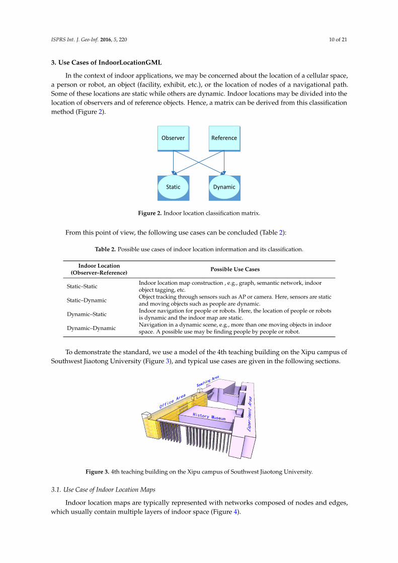
In the context of indoor applications, we may be concerned about the location of a cellular space,a person or robot, an object (facility, exhibit, etc.), or the location of nodes of a navigational path.Some of these locations are static while others are dynamic. Indoor locations may be divided into thelocation of observers and of reference objects. Hence, a matrix can be derived from this classificationmethod (Figure 2).
ISPRS Int. J. Geo-Inf. 2016, 5, 220 10 of 19
ISPRS Int. J. Geo-Inf. 2016, 5, x; doi: FOR PEER REVIEW www.mdpi.com/journal/ijgi
3. Use Cases of IndoorLocationGML
In the context of indoor applications, we may be concerned about the location of a cellular space, a person or robot, an object (facility, exhibit, etc.), or the location of nodes of a navigational path. Some of these locations are static while others are dynamic. Indoor locations may be divided into the location of observers and of reference objects. Hence, a matrix can be derived from this classification method (Figure 2).
Observer Reference
Static Dynamic
Figure 2. Indoor location classification matrix.
From this point of view, the following use cases can be concluded (Table 2):
Table 2. Possible use cases of indoor location information and its classification.
Indoor Location (Observer–Reference)
Possible Use Cases
Static–Static Indoor location map construction , e.g., graph, semantic network, indoor object tagging, etc.
Static–Dynamic Object tracking through sensors such as AP or camera. Here, sensors are static and moving objects such as people are dynamic.
Dynamic–Static Indoor navigation for people or robots. Here, the location of people or robots is dynamic and the indoor map are static.
Dynamic–Dynamic Navigation in a dynamic scene, e.g., more than one moving objects in indoor space. A possible use may be finding people by people or robot.
To demonstrate the standard, we use a model of the 4th teaching building on the Xipu campus of Southwest Jiaotong University (Figure 3), and typical use cases are given in the following sections.
Figure 3. 4th teaching building on the Xipu campus of Southwest Jiaotong University.
3.1. Use Case of Indoor Location Maps
Indoor location maps are typically represented with networks composed of nodes and edges, which usually contain multiple layers of indoor space (Figure 4).
Figure 2. Indoor location classification matrix.
From this point of view, the following use cases can be concluded (Table 2):
Table 2. Possible use cases of indoor location information and its classification.
Indoor Location(Observer–Reference) Possible Use Cases
Static–Static Indoor location map construction , e.g., graph, semantic network, indoorobject tagging, etc.
Static–Dynamic Object tracking through sensors such as AP or camera. Here, sensors are staticand moving objects such as people are dynamic.
Dynamic–Static Indoor navigation for people or robots. Here, the location of people or robotsis dynamic and the indoor map are static.
Dynamic–Dynamic Navigation in a dynamic scene, e.g., more than one moving objects in indoorspace. A possible use may be finding people by people or robot.
To demonstrate the standard, we use a model of the 4th teaching building on the Xipu campus ofSouthwest Jiaotong University (Figure 3), and typical use cases are given in the following sections.
ISPRS Int. J. Geo-Inf. 2016, 5, 220 10 of 19
ISPRS Int. J. Geo-Inf. 2016, 5, x; doi: FOR PEER REVIEW www.mdpi.com/journal/ijgi
3. Use Cases of IndoorLocationGML
In the context of indoor applications, we may be concerned about the location of a cellular space, a person or robot, an object (facility, exhibit, etc.), or the location of nodes of a navigational path. Some of these locations are static while others are dynamic. Indoor locations may be divided into the location of observers and of reference objects. Hence, a matrix can be derived from this classification method (Figure 2).
Observer Reference
Static Dynamic
Figure 2. Indoor location classification matrix.
From this point of view, the following use cases can be concluded (Table 2):
Table 2. Possible use cases of indoor location information and its classification.
Indoor Location (Observer–Reference)
Possible Use Cases
Static–Static Indoor location map construction , e.g., graph, semantic network, indoor object tagging, etc.
Static–Dynamic Object tracking through sensors such as AP or camera. Here, sensors are static and moving objects such as people are dynamic.
Dynamic–Static Indoor navigation for people or robots. Here, the location of people or robots is dynamic and the indoor map are static.
Dynamic–Dynamic Navigation in a dynamic scene, e.g., more than one moving objects in indoor space. A possible use may be finding people by people or robot.
To demonstrate the standard, we use a model of the 4th teaching building on the Xipu campus of Southwest Jiaotong University (Figure 3), and typical use cases are given in the following sections.
Figure 3. 4th teaching building on the Xipu campus of Southwest Jiaotong University.
3.1. Use Case of Indoor Location Maps
Indoor location maps are typically represented with networks composed of nodes and edges, which usually contain multiple layers of indoor space (Figure 4).
Figure 3. 4th teaching building on the Xipu campus of Southwest Jiaotong University.
3.1. Use Case of Indoor Location Maps
Indoor location maps are typically represented with networks composed of nodes and edges,which usually contain multiple layers of indoor space (Figure 4).

ISPRS Int. J. Geo-Inf. 2016, 5, 220 11 of 21ISPRS Int. J. Geo-Inf. 2016, 5, 220 11 of 19
ISPRS Int. J. Geo-Inf. 2016, 5, x; doi: FOR PEER REVIEW www.mdpi.com/journal/ijgi
Figure 4. An example of an indoor map.
A node usually represents a cellular element of indoor space (e.g., rooms, corridors, doors, etc.), and an edge represents the topology relationship between two nodes, such as connectivity and adjacency. In addition to the basic cellular network of indoor space, more information can be provided by IndoorLocationGML, such as distance, directional relationship, and order relationship between two nodes. Semantics such as floor, function, and the name of nodes can be integrated in this framework to create a semantic-rich indoor location map.
Nodes are fixed and non-changeable elements of the framework of an indoor location map, therefore IndoorAbsoluteLocation is suitable for representing the geometric characteristics of nodes. The gml:id property of IndoorAbsoluteLocation that is inherited from gml:AbstractFeature, can be specified to guarantee that each node has a unique identifier, in case of later reference. A node can thus be described with the following XML document.
< IndoorAbsoluteLocation gml:id="0010"> <life gml:id="TP01">
<gml:TimePeriod> <gml:begin>
<gml:TimeInstant gml:id="TI01"> <gml:timePosition>2005-04-06</gml:timePosition>
</gml:TimeInstant> </gml:begin> <gml:end>
<gml:TimeInstant gml:id="TI02"> <gml:timePosition>2035-04-06</gml:timePosition>
</gml:TimeInstant> </gml:end>
</gml:TimePeriod> </life> <coordinate srsName="#mycrs" srsDimension="3">
<gml:pos>12.5 6.4 22.0</gml:pos> </coordinate>
</IndoorAbsoluteLocation>
A node is represented by a coordinate in a given coordinate reference system. “#mycrs” here is the unique identifier of a coordinate reference system defined in a CRS dictionary or elsewhere. The node also contains information describing its duration from a time position.
Edges between two nodes contain information describing their relative relationships, and thus can be represented by IndoorRelativeLocation. Suppose we have two nodes whose IDs are “0010” and “0011”. Node “0011” is chosen as the reference, and the IndoorRelativeLocation of node “0010” can be described as follows.
<IndoorRelativeLocation gml:id="0010-0011"> <geometricLocation>
<geometricDescription> <reference xlinks:href="#0011"/> <direction>
<horizontalAngle> <Degree>270</Degree>
Figure 4. An example of an indoor map.
A node usually represents a cellular element of indoor space (e.g., rooms, corridors, doors,etc.), and an edge represents the topology relationship between two nodes, such as connectivityand adjacency. In addition to the basic cellular network of indoor space, more information can beprovided by IndoorLocationGML, such as distance, directional relationship, and order relationshipbetween two nodes. Semantics such as floor, function, and the name of nodes can be integrated in thisframework to create a semantic-rich indoor location map.
Nodes are fixed and non-changeable elements of the framework of an indoor location map,therefore IndoorAbsoluteLocation is suitable for representing the geometric characteristics of nodes.The gml:id property of IndoorAbsoluteLocation that is inherited from gml:AbstractFeature, can bespecified to guarantee that each node has a unique identifier, in case of later reference. A node canthus be described with the following XML document.
<IndoorAbsoluteLocation gml:id="0010"><life gml:id="TP01">
<gml:TimePeriod><gml:begin>
<gml:TimeInstant gml:id="TI01"><gml:timePosition>2005-04-06</gml:timePosition>
</gml:TimeInstant></gml:begin><gml:end>
<gml:TimeInstant gml:id="TI02"><gml:timePosition>2035-04-06</gml:timePosition>
</gml:TimeInstant></gml:end>
</gml:TimePeriod></life><coordinate srsName="#mycrs" srsDimension="3">
<gml:pos>12.5 6.4 22.0</gml:pos></coordinate>
</IndoorAbsoluteLocation>
A node is represented by a coordinate in a given coordinate reference system. “#mycrs” hereis the unique identifier of a coordinate reference system defined in a CRS dictionary or elsewhere.The node also contains information describing its duration from a time position.
Edges between two nodes contain information describing their relative relationships, and thuscan be represented by IndoorRelativeLocation. Suppose we have two nodes whose IDs are “0010” and

ISPRS Int. J. Geo-Inf. 2016, 5, 220 12 of 21
“0011”. Node “0011” is chosen as the reference, and the IndoorRelativeLocation of node “0010” can bedescribed as follows.
<IndoorRelativeLocation gml:id="0010-0011"><geometricLocation>
<geometricDescription><reference xlinks:href="#0011"/><direction>
<horizontalAngle><Degree>270</Degree><ReferenceDirection>North</ReferenceDirection>
</horizontalAngle><verticalAngle>
<Degree>0</Degree><ReferenceDirection>Up</ReferenceDirection>
</verticalAngle></direction><distance >5</distance>
</geometricDescription></geometricLocation><semanticLocation>
<semanticDescription><reference xlinks:href="#0011"/><description >Node 0011 is the door node of room 4520</description><direction>FRONT</direction><order>NEXT</order><distance>
<description>There are 6 meters from the center of room 4520 to the backdoor</description>
<distance>6</distance></distance>
</semanticDescription><floor>5</floor><function>Meeting room</function><name>RoomNode0010</name><roomNumber>4520</roomNumber>
</semanticLocation></IndoorAbsoluteLocation>
The entire indoor location map can then be represented with nodes and the possible relationsbetween nodes.
3.2. Use Case of Indoor Navigation for Humans and Robots
Indoor navigation for humans and robots may differ from the objects they are interested in. In thesituation of a large shopping mall, humans may be concerned about shops, handrails, elevators, etc.and robots may be concerned about obstacles (non-navigable objects), doors, sensors (AP, RFID), etc.In emergency situations, objects that humans or robots are concerned with may differ from those innormal situations, e.g., the location of escape ladders, extinguishers, fire spots, the tendency of fire tospread, etc. Robots may also be concerned about the location of humans, and trying to rescue them.Humans can understand the environment more easily than robots, so, different indoor location mapsand navigation paths should be provided for humans and robots.

ISPRS Int. J. Geo-Inf. 2016, 5, 220 13 of 21
A navigation path is derived from the indoor location map by calculating the best path from thestart point to destination. It consists of nodes and directional edges, and to represent it is similar to therepresentation of indoor location maps. Additional reference objects can be included in the path aslandmarks. For example, navigation for humans can add easily recognisable rooms as reference objectsat a corner of the path, to help people easily recognise the path node. Information on the location ofobstacles and sensors (AP, RFID) is more relevant to robots, enabling them to better understand theenvironment (see Figure 5).ISPRS Int. J. Geo-Inf. 2016, 5, 220 13 of 19
ISPRS Int. J. Geo-Inf. 2016, 5, x; doi: FOR PEER REVIEW www.mdpi.com/journal/ijgi
Figure 5. Indoor navigation for humans (top) and robots (bottom).
A navigation path for humans is demonstrated in the following code list; the navigation path for robots is similar to the navigation path for humans, except that there are more nodes on the path and different references are selected such as APs and RFIDs.
<IndoorLocation gml:id="IndoorPath-Human"> <!--Nodes of path are described with IndoorAbsoluteLocation--> <IndoorAbsoluteLocation gml:id="HP01" crs="#indoorCRS">
<coordinate srsDimension="3"> <gml:pos>7.22 115.13 17.00</gml:pos>
</coordinate> </IndoorAbsoluteLocation>
<IndoorAbsoluteLocation gml:id=" HP02" crs="#indoorCRS"> <coordinate srsDimension="3">
<gml:pos>7.22 107.11 19.00</gml:pos> </coordinate>
</IndoorAbsoluteLocation> <IndoorAbsoluteLocation gml:id=" HP03" crs="#indoorCRS">
<coordinate srsDimension="3"> <gml:pos>8.22 107.11 19.00</gml:pos>
</coordinate> </IndoorAbsoluteLocation>
<IndoorAbsoluteLocation gml:id=" HP03" crs="#indoorCRS"> <coordinate srsDimension="3">
<gml:pos>8.22 8.12 19.00</gml:pos> </coordinate>
</IndoorAbsoluteLocation> <IndoorAbsoluteLocation gml:id=" HP03" crs="#indoorCRS">
<coordinate srsDimension="3"> <gml:pos>11.00 8.12 19.00</gml:pos>
</coordinate> </IndoorAbsoluteLocation> <!-- Indoor relative location of HP03 relative to room 4548--> <IndoorRelativeLocation gml:id="HP03-4548">
<geometricLocation> <geometricDescription>
<reference xlinks:href="#F5-4548"/> <direction>
<horizontalAngle> <Degree>120</Degree> <ReferenceDirection>North</ReferenceDirection>
</horizontalAngle> <verticalAngle>
<Degree>0</Degree> <ReferenceDirection>Up</ReferenceDirection>
</verticalAngle> </direction>
Figure 5. Indoor navigation for humans (top) and robots (bottom).
A navigation path for humans is demonstrated in the following code list; the navigation path forrobots is similar to the navigation path for humans, except that there are more nodes on the path anddifferent references are selected such as APs and RFIDs.
<IndoorLocation gml:id="IndoorPath-Human"><!–Nodes of path are described with IndoorAbsoluteLocation–><IndoorAbsoluteLocation gml:id="HP01" crs="#indoorCRS">
<coordinate srsDimension="3"><gml:pos>7.22 115.13 17.00</gml:pos>
</coordinate></IndoorAbsoluteLocation><IndoorAbsoluteLocation gml:id=" HP02" crs="#indoorCRS">
<coordinate srsDimension="3"><gml:pos>7.22 107.11 19.00</gml:pos>
</coordinate></IndoorAbsoluteLocation><IndoorAbsoluteLocation gml:id=" HP03" crs="#indoorCRS">
<coordinate srsDimension="3"><gml:pos>8.22 107.11 19.00</gml:pos>
</coordinate></IndoorAbsoluteLocation><IndoorAbsoluteLocation gml:id=" HP03" crs="#indoorCRS">
<coordinate srsDimension="3"><gml:pos>8.22 8.12 19.00</gml:pos>
</coordinate></IndoorAbsoluteLocation><IndoorAbsoluteLocation gml:id=" HP03" crs="#indoorCRS">

ISPRS Int. J. Geo-Inf. 2016, 5, 220 14 of 21
<coordinate srsDimension="3"><gml:pos>11.00 8.12 19.00</gml:pos>
</coordinate></IndoorAbsoluteLocation><!– Indoor relative location of HP03 relative to room 4548–><IndoorRelativeLocation gml:id="HP03-4548">
<geometricLocation><geometricDescription>
<reference xlinks:href="#F5-4548"/><direction>
<horizontalAngle><Degree>120</Degree><ReferenceDirection>North</ReferenceDirection>
</horizontalAngle><verticalAngle>
<Degree>0</Degree><ReferenceDirection>Up</ReferenceDirection>
</verticalAngle></direction>
<distance >5</distance></geometricDescription>
</geometricLocation><semanticLocation>
<semanticDescription><reference xlinks:href="#F5-4548"/><description >Node F5-4548 is a office in the 5th floor of office area</description><direction>LEFT</direction><order>PREVIOUS</order><distance>
<description>There are 5 meters from node HP03 to room 4548</description><distance>5</distance>
</distance></semanticDescription><floor>5</floor><function>Path node</function><name>HP03</name><roomNumber>0000</roomNumber>
</semanticLocation></IndoorRelativeLocation>...Other relative locations
</IndoorLocation>
The location of humans or robots changes constantly in the process of navigation, and is thereforedynamic. The location of moving objects should be updated in a fixed frequency, which can berepresented by a location sequence where each location corresponds to a time instance. Indoor locationas defined in IndoorLocationGML has a life property represented by gml:TimePeriod, so it is suitablefor describing the dynamic location sequence by specifying each location’s start and end time points.

ISPRS Int. J. Geo-Inf. 2016, 5, 220 15 of 21
3.3. Use Case of Indoor Objects Management
Location information is a key factor in indoor objects management. Indoor objects refer to indoorfacilities in a building, books in a library, exhibits in a museum, etc. Facilities are objects such asextinguishers, circuit controllers, and smoke detectors (see Figure 6), which are an important partof indoor installations in both normal and emergency situations. Precisely tracking the location ofan indoor facility at any time is important in the operation process of a building.
ISPRS Int. J. Geo-Inf. 2016, 5, 220 14 of 19
ISPRS Int. J. Geo-Inf. 2016, 5, x; doi: FOR PEER REVIEW www.mdpi.com/journal/ijgi
<distance >5</distance> </geometricDescription>
</geometricLocation> <semanticLocation>
<semanticDescription> <reference xlinks:href="#F5-4548"/> <description >Node F5-4548 is a office in the 5th floor of office area</description> <direction>LEFT</direction> <order>PREVIOUS</order> <distance>
<description>There are 5 meters from node HP03 to room 4548</description> <distance>5</distance>
</distance> </semanticDescription> <floor>5</floor> <function>Path node</function> <name>HP03</name> <roomNumber>0000</roomNumber>
</semanticLocation> </IndoorRelativeLocation>
...Other relative locations </IndoorLocation>
The location of humans or robots changes constantly in the process of navigation, and is therefore dynamic. The location of moving objects should be updated in a fixed frequency, which can be represented by a location sequence where each location corresponds to a time instance. Indoor location as defined in IndoorLocationGML has a life property represented by gml:TimePeriod, so it is suitable for describing the dynamic location sequence by specifying each location’s start and end time points.
3.3. Use Case of Indoor Objects Management
Location information is a key factor in indoor objects management. Indoor objects refer to indoor facilities in a building, books in a library, exhibits in a museum, etc. Facilities are objects such as extinguishers, circuit controllers, and smoke detectors (see Figure 6), which are an important part of indoor installations in both normal and emergency situations. Precisely tracking the location of an indoor facility at any time is important in the operation process of a building.
Figure 6. Indoor facilities management.
For demonstrating the example above, a code list is given as follow:
<IndoorLocation gml:id="Facilities"> <!—Location of indoor facilities are described with IndoorAbsoluteLocation--> <!—Air conditioner--> <IndoorAbsoluteLocation gml:id="AC01" crs="#indoorCRS">
<coordinate srsDimension="3"> <gml:pos>14.00 13.12 19.00</gml:pos>
</coordinate> </IndoorAbsoluteLocation> … <!—Extinguisher-->
<IndoorAbsoluteLocation gml:id=" EX01" crs="#indoorCRS">
Figure 6. Indoor facilities management.
For demonstrating the example above, a code list is given as follow:
<IndoorLocation gml:id="Facilities"><!—Location of indoor facilities are described with IndoorAbsoluteLocation–><!—Air conditioner–><IndoorAbsoluteLocation gml:id="AC01" crs="#indoorCRS">
<coordinate srsDimension="3"><gml:pos>14.00 13.12 19.00</gml:pos>
</coordinate></IndoorAbsoluteLocation>
. . .<!—Extinguisher–>
<IndoorAbsoluteLocation gml:id=" EX01" crs="#indoorCRS"><coordinate srsDimension="3">
<gml:pos>8.00 17.00 19.50</gml:pos></coordinate>
</IndoorAbsoluteLocation>. . .
<!– Indoor relative location of AC01 relative to room 4520–><IndoorRelativeLocation gml:id="AC01-4520">
<geometricLocation><geometricDescription>
<reference xlinks:href="#F5-4520"/><direction>
<horizontalAngle><Degree>120</Degree><ReferenceDirection>North</ReferenceDirection>
</horizontalAngle><verticalAngle>
<Degree>0</Degree><ReferenceDirection>Up</ReferenceDirection>
</verticalAngle>

ISPRS Int. J. Geo-Inf. 2016, 5, 220 16 of 21
</direction><distance >3</distance>
</geometricDescription></geometricLocation><semanticLocation>
<semanticDescription><reference xlinks:href="#F5-4520"/><description >AC01 is in room 4520 and placed near the back window of room
4520</description><direction>LEFT</direction><order>NEXT</order><distance>
<description>There are 3 meters from AC01 to the centre of room4520</description>
<distance>3</distance></distance><topology>CONTAIN<topology>
</semanticDescription><floor>5</floor><function>Air conditioner</function><name>AC01</name><roomNumber>4520</roomNumber>
</semanticLocation></IndoorRelativeLocation>...Other relative locations
</IndoorLocation>
The library, floors, bookshelves, and books can be arranged topologically, as demonstratedin Figure 7. The precise indoor location (spatial or temporal) of the books can be described byusing IndoorLocationGML.
ISPRS Int. J. Geo-Inf. 2016, 5, 220 15 of 19
ISPRS Int. J. Geo-Inf. 2016, 5, x; doi: FOR PEER REVIEW www.mdpi.com/journal/ijgi
<coordinate srsDimension="3"> <gml:pos>8.00 17.00 19.50</gml:pos>
</coordinate> </IndoorAbsoluteLocation> … <!-- Indoor relative location of AC01 relative to room 4520--> <IndoorRelativeLocation gml:id="AC01-4520">
<geometricLocation> <geometricDescription>
<reference xlinks:href="#F5-4520"/> <direction>
<horizontalAngle> <Degree>120</Degree> <ReferenceDirection>North</ReferenceDirection>
</horizontalAngle> <verticalAngle>
<Degree>0</Degree> <ReferenceDirection>Up</ReferenceDirection>
</verticalAngle> </direction> <distance >3</distance>
</geometricDescription> </geometricLocation> <semanticLocation>
<semanticDescription> <reference xlinks:href="#F5-4520"/> <description >AC01 is in room 4520 and placed near the back window of room 4520</description> <direction>LEFT</direction> <order>NEXT</order> <distance>
<description>There are 3 meters from AC01 to the centre of room 4520</description> <distance>3</distance>
</distance> <topology>CONTAIN<topology>
</semanticDescription> <floor>5</floor> <function>Air conditioner</function> <name>AC01</name> <roomNumber>4520</roomNumber>
</semanticLocation> </IndoorRelativeLocation>
...Other relative locations </IndoorLocation>
The library, floors, bookshelves, and books can be arranged topologically, as demonstrated in Figure 7. The precise indoor location (spatial or temporal) of the books can be described by using IndoorLocationGML.
Figure 7. Looking for books in a library.
4. Seamless Indoor–Outdoor Navigation Example
IndoorLocationGML and IndoorGML or any other standards defined by utilising the basic types follow the inheritance hierarchical structures of GML and are known as the application
Figure 7. Looking for books in a library.
4. Seamless Indoor–Outdoor Navigation Example
IndoorLocationGML and IndoorGML or any other standards defined by utilising the basic typesfollow the inheritance hierarchical structures of GML and are known as the application schema ofGML. GML defines a framework of geo-information by providing basic types, the principles of classdefinition and inheritance, and describing the relationships between classes. Thus, different GMLapplication schemas are easily integrated. Elements in different XML documents can have an gml:idproperty, and can then be referenced as external objects facilitated by xlink:href.

ISPRS Int. J. Geo-Inf. 2016, 5, 220 17 of 21
IndoorLocationGML itself is used to describe indoor multi-dimensional location information.Navigating from outdoors to indoors requires a combination of outdoor and indoor paths. Every indoorspace contains at least one entrance connecting it with the outdoor space. In IndoorGML, an entrance isrepresented by an anchor node, which is used for connecting and representing the topology relationshipbetween the outdoor and indoor spaces. An anchor node can also contain parameters for coordinatingtransformations, enabling a seamless location transformation from outdoors to indoors (see Figure 8).
ISPRS Int. J. Geo-Inf. 2016, 5, 220 16 of 19
ISPRS Int. J. Geo-Inf. 2016, 5, x; doi: FOR PEER REVIEW www.mdpi.com/journal/ijgi
schema of GML. GML defines a framework of geo-information by providing basic types, the principles of class definition and inheritance, and describing the relationships between classes. Thus, different GML application schemas are easily integrated. Elements in different XML documents can have an gml:id property, and can then be referenced as external objects facilitated by xlink:href.
IndoorLocationGML itself is used to describe indoor multi-dimensional location information. Navigating from outdoors to indoors requires a combination of outdoor and indoor paths. Every indoor space contains at least one entrance connecting it with the outdoor space. In IndoorGML, an entrance is represented by an anchor node, which is used for connecting and representing the topology relationship between the outdoor and indoor spaces. An anchor node can also contain parameters for coordinating transformations, enabling a seamless location transformation from outdoors to indoors (see Figure 8).
Figure 8. Anchor node connecting indoor and outdoor networks (Figure 16 of IndoorGML version1.0 document).
The IndoorGML document, the dataset of outdoor ground transportation network, and the IndoorLocationGML document can be combined to provide seamless indoor–outdoor LBS. The anchor node should be defined in both the IndoorGML document and the outdoor dataset to connect the indoor space to the outdoors. Though IndoorGML supports indoor multi-layered networks for indoor navigation, IndoorLocationGML can provide more precise indoor multi-dimension location information and rich semantics, as a complement to IndoorGML, applying location information to indoor LBS. As discussed in Section 3.2, dynamic localisation and navigation can be achieved by using IndoorLocationGML.
The navigation path is composed of an outdoor and an indoor section. Outdoor navigation is typically facilitated by road networks, which consist of road segments. A road segment can be represented by a list of nodes, and each node has a unique ID and a pair (longitude, latitude) or a trio (longitude, latitude, altitude) of coordinates. The indoor section is instead represented by a list of three-dimensional coordinates in a Cartesian coordinate system. An example of navigating from the starting point to the destination (Room 4520) is given below (Figure 9). In this example, we create three pieces of GML code: the first part is described with GML and represents the outdoor section of the path; the second is the indoor section of the path, which is described with IndoorLocationGML; a series of nodes are represented with IndoorAbsoluteLocation and the relative location is also provided for demonstration of this standard; the third part is described with IndoorGML, and an anchor node is used to connect the indoor and outdoor section of the path.
Figure 8. Anchor node connecting indoor and outdoor networks (Figure 16 of IndoorGML version1.0document).
The IndoorGML document, the dataset of outdoor ground transportation network, and theIndoorLocationGML document can be combined to provide seamless indoor–outdoor LBS. The anchornode should be defined in both the IndoorGML document and the outdoor dataset to connect theindoor space to the outdoors. Though IndoorGML supports indoor multi-layered networks forindoor navigation, IndoorLocationGML can provide more precise indoor multi-dimension locationinformation and rich semantics, as a complement to IndoorGML, applying location information toindoor LBS. As discussed in Section 3.2, dynamic localisation and navigation can be achieved byusing IndoorLocationGML.
The navigation path is composed of an outdoor and an indoor section. Outdoor navigationis typically facilitated by road networks, which consist of road segments. A road segment can berepresented by a list of nodes, and each node has a unique ID and a pair (longitude, latitude) or a trio(longitude, latitude, altitude) of coordinates. The indoor section is instead represented by a list ofthree-dimensional coordinates in a Cartesian coordinate system. An example of navigating from thestarting point to the destination (Room 4520) is given below (Figure 9). In this example, we create threepieces of GML code: the first part is described with GML and represents the outdoor section of thepath; the second is the indoor section of the path, which is described with IndoorLocationGML; a seriesof nodes are represented with IndoorAbsoluteLocation and the relative location is also provided fordemonstration of this standard; the third part is described with IndoorGML, and an anchor node isused to connect the indoor and outdoor section of the path.

ISPRS Int. J. Geo-Inf. 2016, 5, 220 18 of 21
ISPRS Int. J. Geo-Inf. 2016, 5, 220 17 of 19
ISPRS Int. J. Geo-Inf. 2016, 5, x; doi: FOR PEER REVIEW www.mdpi.com/journal/ijgi
Figure 9. An example of seamless indoor–outdoor navigation.
<!-- Outdoor transportation network data set, filename: OutdoorExp.xml--> <gml:Point srsName="#geodeticCRS" id="NodeListofOutdoor" axisLabels="lat long alt" uomLabels="deg deg m">
<gml:pos id="Start-point">30.766376990623694 103.9879810720322 524</gml:pos> <gml:pos id="Outdoor-P2">30.766458439227996 103.9882126539487 524</gml:pos> <gml:pos id="Outdoor-P3">30.766341659288557 103.9882716625471 524</gml:pos> <gml:pos id="Outdoor-Entrance">30.766320156242887 103.9882323145866 524</gml:pos>
</gml:Point> <!-- IndoorLocationGML data set, filename: IndoorLocationExp.xml--> <IndoorLocation gml:id="IndoorPath">
<!--Nodes of path are described with IndoorAbsoluteLocation--> <IndoorAbsoluteLocation gml:id="F1-Entrance" crs="#indoorCRS"> <coordinate srsDimension="3"> <gml:pos>7.22 115.13 0.74</gml:pos> </coordinate> </IndoorAbsoluteLocation> <IndoorAbsoluteLocation gml:id="F1-P2" crs="#indoorCRS"> <coordinate srsDimension="3"> <gml:pos>7.22 107.11 0.74</gml:pos> </coordinate> </IndoorAbsoluteLocation> ...Nodes F1-P3, F1-P4, F1-P5, F2-P6, F2-P7, F2-P8, F2-P9, F3-P10, F3-P11, F3-P12, F3-P13, F4-P14, F4-P15, F4-P16, F4-P17, F5-P18, F5-C-P19, F5-C-P20, F5-C-P21 are omitted here <IndoorAbsoluteLocation gml:id="F5-C-P22" crs="#indoorCRS"> <coordinate srsDimension="3"> <gml:pos>7.22 8.12 19.00</gml:pos> </coordinate> </IndoorAbsoluteLocation> <IndoorAbsoluteLocation gml:id="F5-Room5420" crs="#indoorCRS"> <coordinate srsDimension="3"> <gml:pos>11.00 8.12 19.00</gml:pos> </coordinate> </IndoorAbsoluteLocation> <!-- Indoor relative location of F5-C-P20 relative to restroom1--> <IndoorRelativeLocation gml:id="F5-C-P20-F5-Restroom1"> <geometricLocation> <geometricDescription> <reference xlinks:href="#F5-Restroom1"/> <direction> <horizontalAngle> <Degree>300</Degree> <ReferenceDirection>North</ReferenceDirection>
</horizontalAngle> <verticalAngle> <Degree>0</Degree> <ReferenceDirection>Up</ReferenceDirection>
</verticalAngle> </direction>
Figure 9. An example of seamless indoor–outdoor navigation.
<!– Outdoor transportation network data set, filename: OutdoorExp.xml–><gml:Point srsName="#geodeticCRS" id="NodeListofOutdoor" axisLabels="lat long alt"uomLabels="deg deg m">
<gml:pos id="Start-point">30.766376990623694 103.9879810720322 524</gml:pos><gml:pos id="Outdoor-P2">30.766458439227996 103.9882126539487 524</gml:pos><gml:pos id="Outdoor-P3">30.766341659288557 103.9882716625471 524</gml:pos><gml:pos id="Outdoor-Entrance">30.766320156242887 103.9882323145866 524</gml:pos>
</gml:Point>
<!– IndoorLocationGML data set, filename: IndoorLocationExp.xml–><IndoorLocation gml:id="IndoorPath">
<!–Nodes of path are described with IndoorAbsoluteLocation–><IndoorAbsoluteLocation gml:id="F1-Entrance" crs="#indoorCRS">
<coordinate srsDimension="3"><gml:pos>7.22 115.13 0.74</gml:pos></coordinate>
</IndoorAbsoluteLocation><IndoorAbsoluteLocation gml:id="F1-P2" crs="#indoorCRS">
<coordinate srsDimension="3"><gml:pos>7.22 107.11 0.74</gml:pos></coordinate>
</IndoorAbsoluteLocation>...Nodes F1-P3, F1-P4, F1-P5, F2-P6, F2-P7, F2-P8, F2-P9,F3-P10, F3-P11, F3-P12, F3-P13, F4-P14, F4-P15, F4-P16,F4-P17, F5-P18, F5-C-P19, F5-C-P20, F5-C-P21 are omitted here<IndoorAbsoluteLocation gml:id="F5-C-P22" crs="#indoorCRS">
<coordinate srsDimension="3"><gml:pos>7.22 8.12 19.00</gml:pos></coordinate>
</IndoorAbsoluteLocation><IndoorAbsoluteLocation gml:id="F5-Room5420" crs="#indoorCRS">
<coordinate srsDimension="3"><gml:pos>11.00 8.12 19.00</gml:pos></coordinate>

ISPRS Int. J. Geo-Inf. 2016, 5, 220 19 of 21
</IndoorAbsoluteLocation><!– Indoor relative location of F5-C-P20 relative to restroom1–><IndoorRelativeLocation gml:id="F5-C-P20-F5-Restroom1">
<geometricLocation><geometricDescription><reference xlinks:href="#F5-Restroom1"/><direction><horizontalAngle><Degree>300</Degree><ReferenceDirection>North</ReferenceDirection>
</horizontalAngle><verticalAngle><Degree>0</Degree><ReferenceDirection>Up</ReferenceDirection>
</verticalAngle></direction><distance >5</distance>
</geometricDescription></geometricLocation>
<semanticLocation><semanticDescription><reference xlinks:href="#F5-Restroom1"/><description >Node F5-Restroom1 is a restroom in the 5th floor of office area</description><direction>Right</direction><order>NEXT</order><distance><description>There are 5 meters from node F5-C-P20 to the restroom1</description><distance>5</distance></distance>
</semanticDescription><floor>5</floor>
<function>Path node</function><name>F5-C-P20</name>
<roomNumber>0000</roomNumber></semanticLocation>
</IndoorRelativeLocation>...Other relative locations
</IndoorLocation>
<!– IndoorGML data set, filename: IndoorGMLExp.xml–><AnchorSpace>
<externalReference><externalObject>
<name>Outdoor-Entrance</name></externalObject><externalObject>
<name>F1-Entrance</name></externalObject>
</externalReference></AnchorSpace>
ISPRS Int. J. Geo-Inf. 2016, 5, 220 20 of 21
5. Concluding Remarks
The rapid development of Chinese navigation and positioning systems means that standardizingindoor–outdoor seamless navigation and LBS geo-information is necessary. CityGML focuses onrepresenting the geometry, semantics, and appearance of urban-related objects, such as buildings,building parts, installations, bridges, tunnels, etc. Instead of representing building architecturalcomponents, IndoorGML is concerned with the spaces defined by architectural components,where objects can be located and navigated, and is also concerned with the relationships (e.g., topology)between spaces. Representing multi-layered networks of cellular space is the main objective of theIndoorGML standard. However, no universal standard for indoor location information currently exists,and only rudimentary indoor navigation and positioning information is supplied in correlation studies.
The proposed IndoorLocationGML standard in this paper has given a framework of ubiquitousindoor location information description for both accurate consideration (Indoor absolute location) andrough consideration (Indoor relative location) and their relations, hence it is complete. Together withother companion standards that have been proposed in recent years, including interface standardsfor indoor and outdoor multimodal co-location services, data specifications of electronic maps forweb services, and data model and exchange formats for navigable spatial databases, this standardaddresses the current urgent requirements and provides support to industrial applications.
Acknowledgments: This paper was supported by the National Nature Science Foundation of China (No. 41471320and 41471332) and the National High Technology Research and Development Program of China (2015AA123901).Dr. Lei Niu’s suggestions during the revision stage of this paper is appreciated.
Author Contributions: Qing Zhu, Qing Xiong, Yulin Ding, Yeting Zhang, Yan Zhou, and Yun Li contributed tothe IndoorLocationGML standard. The use cases is designed by Yun Li. The application section is designed byYun Li and Yan Zhou. This paper is written by Yun Li. Qing Zhu and Sisi Zlatanova also provided guidance andadvice on the study.
Conflicts of Interest: The authors declare no conflict of interest.
References
1. Zlatanova, S.; Sithole, G.; Nakagawa, M.; Zhu, Q. Problems in indoor mapping and modelling. ISPRS Arch.Photogramm. Remote Sens. Spat.l Inf. Sci. 2013, 4, 51–55. [CrossRef]
2. Winter, S. Indoor spatial information. Int. J. 3D Inf. Model. 2012, 3, 25–42. [CrossRef]3. Lee, J.; Li, K.; Zlatanova, S.; Kolbe, T.H.; Nagel, C.; Becher, T. OGC IndoorGML, Version 1.0. OGC Doc. No.
14-005r1. Open Geospatial Consortium: 35 Main Street, Suite 5, Wayland, MA, USA, 2014.4. Clemens, P. OpenGIS Geography Markup Language (GML) Encoding Standard, Version 3.2.1. OGC Doc.
No. 07-036. Open Geospatial Consortium: 35 Main Street, Suite 5, Wayland, MA, USA, 2014.5. Gröger, G.; Plümer, L. CityGM—Interoperable semantic 3D city models. ISPRS J. Photogramm. Remote Sens.
2012, 5, 12–33. [CrossRef]6. Li, N.; Burcin, B.; Krishnamachari, B.; Soibelman, L. A BIM centered indoor localization algorithm to support
building fire emergency response operations. Autom. Constr. 2014, 3, 78–89. [CrossRef]7. Tashakkori, H.; Rajabifard, A.; Kalantari, M. A new 3D indoor/outdoor spatial model for indoor emergency
response facilitation. Build. Environ. 2014, 3, 170–182. [CrossRef]8. Yang, L.; Worboys, M. Generation of navigation graphs for indoor space. Int. J. Geogr. Inf. Sci. 2015, 5,
1737–1756. [CrossRef]9. Salveson-Nossum, A. IndoorTubes a novel design for indoor maps. Cartogr. Geogr. Inf. Sci. 2013, 3, 192–200.10. Lorenz, A.; Thierbach, C.; Baur, N.; Holbe, T.H. Map design aspects, route complexity, or social background?
Factors influencing user satisfaction with indoor navigation maps. Cartogr. Geogr. Inf. Sci. 2013, 6, 201–209.[CrossRef]
11. Link, J.Á.B.; Smith, P.; Viol, N.; Wehrle, K. Accurate map-based indoor navigation on the mobile. J. Locat.Based Serv. 2012, 7, 23–43. [CrossRef]
12. Bhargava, P.; Krishnamoorthy, S.; Shrivastava, A.; Nakshathri, A.; Mah, M.; Agrawala, A. Locus: Robust andcalibration-free indoor localization, tracking and navigation for multistory buildings. J. Locat. Based Serv.2015, 11, 187–208. [CrossRef]

ISPRS Int. J. Geo-Inf. 2016, 5, 220 21 of 21
13. Kostavelis, I.; Gasteratos, A. Semantic mapping for mobile robotics tasks: A survey. Robot. Auton. Syst. 2014,12, 86–103. [CrossRef]
14. TamilSelvi, D.; Shalinie, S.M.; Thasneem, A.F.; Sundari, S.G. Optimal path selection for mobile robotnavigation using genetic algorithm in an indoor environment. Adv. Comput. Netw. Secur. Int. Conf. 2011, 12,263–269.
15. Zhu, Q.; Xiong, Q.; Zhao, J. Indoor location information model and intelligent location service. J. Geomat.2014, 10, 1–7.
16. Xiong, Q.; Zhu, Q.; Zlatanova, S.; Huang, L.; Zhou, Y.; Du, Z. Multi-dimensional indoor location informationmodel. Int. Arch. Photogramm. Remote Sens. Spat. Inf. Sci. 2013, 12, 45–49. [CrossRef]
17. Sithole, G.; Zlatanova, S. Position location, place and area: An indoor perspective. ISPRS Ann. Photogramm.Remote Sens. Spat. Inf. Sci. 2016, 4, 89–96. [CrossRef]
© 2016 by the authors; licensee MDPI, Basel, Switzerland. This article is an open accessarticle distributed under the terms and conditions of the Creative Commons Attribution(CC-BY) license (http://creativecommons.org/licenses/by/4.0/).