industrial land visioning in central city los angeles
DESCRIPTION
Inner city industrial land - to retain or recycle?TRANSCRIPT

1
To Retain or Recycle? Industrial Land Visioning for Central City Los Angeles Julie Kim Two-week Examination July 2, 2007
Executive Summary Approximately 8% of the city’s land or 19,000 acres is zoned as industrial. A recent survey revealed that only 20% to 30% of land zoned as industrial in Los Angeles is being used for manufacturing purposes. This report investigates threats to existing industrial use in LA’s downtown Industrial District. The study area, bounded by 4th Street on the North, 8th Street on the South, San Pedro Avenue on the East, and Alameda Street on the West, faces a set of complex, historically rooted social and economic problems. Of the current non-industrial uses in the study area, approximately thirty are residential hotels that accommodate chronically homeless individuals. The region is also home to the most concentrated network of homeless services in the city. The study area presented numerous, possibly unprecedented challenges due to the magnitude of the region’s homeless population. Within the study area, a marginalized population in need of housing is pitted against another marginalized population in need of jobs. Meanwhile, the market encourages a recycling into market-rate residential use that would displace both populations. Those pushing for market-rate residential and commercial conversions contend that industrial land near city centers is outdated, the land remains underutilized, the parcels provided are not large enough to sustain significant economic activity, and the vacancies exacerbate the blight associated with the homeless. The report argues for the study area’s economic viability as a vital wholesale trade and manufacturing hub worth preserving. Its location offers a number of strategic advantages for industrial firms – a proximity to freeways, the Alameda Corridor and a large pool of workers in South and East Los Angeles. Studies show that the study area provides close to 6,000 jobs for the city. Industries in the study area exemplify the small-scale manufacturers that some scholars envision as the key to an “industrial renaissance” in the U.S. with their flexibility and growth rate. These industries tend to thrive in urban environments because they operate in clusters of “compatible and interrelated production facilities (Loomis, 1997).” Findings based on a literature review and site visits inform a set of project goals which include (1) alleviate blight caused by street homeless population, (2) preserve retail jobs and revenue generated from industrial use, (3) fuel new economic growth, and (4)

2
advance land use policy that results in the most efficient use of land, (5) provide urban design amenities designated for use by workers and homeless. In turn, these goals inform a set of policy recommendations. All stakeholders concede that the land is underutilized; therefore, among the most crucial policy prescribed is to incentivize development for preferred uses through density bonus tools and financial breaks. Policymakers should specify low-impact, residential-compatible industrial use and homeless housing for preferred uses. We also learn that regulatory measures alone, such as Industrial Protected Zones (IPZ), are an inadequate means of protecting an industrial base. A more effective approach prescribes a holistic strategy that incorporates a variety of elements including but not limited to financial incentives, technical assistance and infrastructure improvements to retain industrial firms.

3
Table of Contents 1. Introduction 2. Methodology [2.1] Interviews [2.2] Site Analysis through Maps [2.3] Site Reconnaissance 3. Discussion of Findings [3.1] The Significance of Industrial Land in Los Angeles [3.2] The Street Population and the Preservation of Affordable Housing [3.3] Threats to Industrial Land Use and Very Low Income Residents 4. Project Goals 5. Recommendations
[5.1] Implement a flexible approach to land use regulation [5.2] Incentivize the development of preferred land uses [5.3] Adopt a holistic approach to retaining small-scale industrial tenants [5.4] Alleviate blight caused by homeless through pursuing supportive housing and homeless prevention strategies [5.5] Introduce civic space and catalyst project to neighborhood
6. Summary of Implementation Strategy 7. Conclusion Citations Appendix

4
Part 1. Introduction Macroeconomic forces such as globalization have prompted the restructuring and consolidation of industries in response to overseas manufacturing competition. As a result, manufacturing sector in its traditional state has experienced a diminishing role within the American economy. In the past five years, California has lost almost 340,000 manufacturing jobs, some through the displacement of industrial land use (La Gange, 2006). Steadily rising land values adds pressure on urban manufacturing where more profitable residential and commercial products threaten industrial use which occupies the last remaining large tracts of land near city centers. Los Angeles maintains the second largest manufacturing-based economy in the United States behind only Chicago. Manufacturing jobs comprise of 28.5% of the total Los Angeles workforce (La Gange, 2006). With a dwindling manufacturing sector, workers lose their high-paying manufacturing jobs to earn less in service or trade sector employment. Since certain industries create three times as many secondary jobs as the service sector, some argue that manufacturing jobs keep people off of welfare and stabilize troubled neighborhoods. Other scholars contend that the loss of well-paying jobs in the manufacturing sector has reduced the overall wages of the unskilled and thus increased poverty rates (Loomis, 1997). Recently, the mayor issued a citywide moratorium on industrial land use conversion while policymakers address the city’s lack of long-range industrial land use policy direction. Urban land values are steadily rising and some consider current inner city industrial land use abandoned, outdated and underutilized. Homeless advocates, affordable housing activists and market-rate housing developers alike advocate higher intensity development of the last remaining tracts of land near city centers. In West Los Angeles, industrial land is found in small pockets. Its recycling into new residential, office and commercial uses faces little opposition from stakeholder groups who all agree that the land is underutilized. Meanwhile, the industrial land in central city Los Angeles presents a complex set of challenges for determining appropriate policy direction due to the numerous constituencies involved. This report examines the issues emerging from an area of roughly 44 blocks and 260 acres bounded by Fourth Street on the north, Eighth Street on the south, Alameda Street on the east, and San Pedro Street on the West. Sometimes referred to as the Warehouse District or the Los Angeles Downtown Industrial District (LADID), the study region comprises one part of the Central City East neighborhood of Los Angeles as well as downtown’s industrial “core,” the concentration of land zoned for light and heavy industrial use in the Central City Community Plan. Figure 1.1 reveals that light industrial zoning dominates the study region with public facilities zoning dispersed throughout the site. Major public facilities uses include the MTA bus yard along Alameda and Ninth Street Elementary School between 8th and 9th

5
Street. Commercial and high-density residential zoning border the northwestern edge of the site.
Figure 1.1 Map of zoning according to Community Plan. Source: Data adapted from Zone Information and Map Access System (ZIMAS) <http://zimas.lacity.org>

6
Part 2. Methodology My research began with a review of literature discussing trends in recent industrial land use planning and policy. Case studies of various cities and their long-range visions for industrial land use informed much of the literature. Research papers often cited San Francisco, Seattle and Chicago as precedents for both good and bad industrial land use policy. I also used the following methodologies to develop a richer understanding of the highly contested and often misunderstood study region: [2.1] Interviews Rather than a linear process of hypothesizing and discovery, the “snowball” approach guided much of the research conducted on this report. That is, the form and methodology of the research continually evolved depending on my latest findings. For instance, I identified early on key stakeholders through readings and contacted representatives from those groups. Through my informational interviews with the representatives, I was referred to individuals representing other constituencies. I then attempted to track down the secondary set of individuals through the primary set of representatives. I conducted three interviews for this report. I interviewed Sharon Gi of the Community Redevelopment Agency of Los Angeles (CRA/LA) last summer. As a member of the Industrial Land Use Policy Project (ILUPP) task force, along with officials from the planning department, I hoped that she might offer the broadest and least politically biased overview of the key issues impacting the study region. In addition to Ms. Gi, I spoke with representatives from local community-based organizations, Little Tokyo Service Center (LTSC) and the Skid Row Housing Trust (SRHT). LTSC is a community development corporation that represents the interests of low-income or otherwise marginalized Asian and Pacific Islanders throughout Los Angeles County. The organization often focuses on preserving and expanding the stock of affordable housing in Little Tokyo. SRHT represents the interests of individuals and housing located in LA’s Skid Row. [2.2] Site Analysis through Maps I retraced a map of the study region that served two purposes: (1) as a base map for studying and recording site conditions in plan, and (2) for establishing consistency in graphic language between other maps. The first step involved collecting and piecing together aerial snapshots of the study region from Google Earth, the free desktop program offering satellite and aerial maps to the public. Because the program combines imagery acquired from other sources, the views tend to be somewhat outdated. I retrieved these initial aerial maps from Google Earth in August of 2006. The features of the built environment such as the building footprints, curbs delineating blocks, and street widths were approximated based on evaluating the aerial at varying

7
resolutions. The maps generated from the aerial required tracing and highlighting these features on the vector-based graphics program, Adobe Illustrator. This methodology admittedly lacks precision but sufficed for the purposes of the report. [2.3] Site Reconnaissance Through my site visit, I hoped, first and foremost, to correct any assumptions I made about the existing conditions of the site through the Google Earth map. The visit was conducted on two occasions and both visits involved a combination of driving and walking. The decision between driving and walking was somewhat arbitrary; I drove through each street of the study region and walked the blocks I felt safest on foot. To determine how best to leverage the site’s current built form, I noted the following site attributes on my base map during my visit: • Nature of activity along each streets, i.e. which streets are more pedestrian or automobile-oriented. • Concentrations of active street frontage such as retail storefronts. • Open space. • Vacant or seemingly underutilized lots (e.g. surface parking lots, palette storage). • Parcels with land uses conflicting with zoning code. In this case, industrial land use comprises almost the entire study region so I highlighted any use outside of industrial. • Site conditions I perceived as an asset to future redevelopment. • Site conditions I perceived as a constraint to future redevelopment. In addition, I photographed properties that either exemplified a commonly observed building typology within the study region or stood out in its deviancy from the norm (e.g., highrises).
Part 3. Discussion of Findings An evaluation of the study region’s strengths and weaknesses depends heavily on the lens with which one chooses to view the site. As Donald Spivack of the Community Redevelopment Agency of Los Angeles (CRA/LA) observed in his paper about the history of Skid Row, ironically “what most people consider one of the most depressed parts of Los Angeles has one of the best economic growth rates in the city (Spivack, 1998).”
[3.1] The Significance of Industrial Land in Central City Los Angeles The study region occupies roughly 260 acres1 within the area now known as Central City East. Once agricultural land, Central City East first evolved into an industrial district 1 area calculation includes circulation

8
when railroads arrived in Southern California during the 1870s. The flatness of the topography, proximity to the Los Angeles River and new railroad access led to the growth of an agricultural industry centered on the distribution of livestock and produce. Figure 3.1 shows that the study area continues to offer strategic advantage for industrial operations with its proximity to freeways, the Alameda Corridor, and large pool of workers in South and East Los Angeles.
Figure 3.1 Vicinity map of study region. Source: Data adapted from 2001 Thomas Brother’s Guide Planning officials argue that industrial land is a critical component of the Los Angeles economy. Their studies reveal that industrial land provides 13% or $219 million of the city’s overall tax revenue and 28.4% of the city’s jobs. Meanwhile, approximately 8% of the city’s land or 19,000 acres is zoned as industrial (LA Planning, 2006).

9
A recent survey revealed that manufacturing uses and associated commercial activity occupy only 20% to 30% of land zoned as industrial in Los Angeles (Gi, 2006). More recently, policymakers have permitted the conversion of the small pockets of industrial land outside of downtown Los Angeles, mostly found in West Los Angeles, to the residential use favored by the market. Officials deem the land underutilized; the displacement of industries faces little opposition from conflicting stakeholders (Gi, 2006). Allowing the haphazard conversion of the large tract of land comprising of Downtown LA’s “industrial core,” presents a far more complex scenario compounded by the region’s homeless issue. If 20% to 30% constitutes the aggregate percentage of LA County’s industrial land used for manufacturing purposes, manufacturers encompass 52% downtown LA’s industrial land. That is, industrial uses occupy LA’s downtown industrial land significantly more (at least 22% to 32%) than typical industrially zoned land throughout LA County. Figure 3.2 below highlights the study region in relation to the rest of downtown’s industrial core.
Figure 3.2 Study Region in Relation to LA’s Downtown Industrial Core Source: Data adapted from index map. LA Planning, 2006
Total industrial land use for the region identified as area 10 is approximately 50% light or heavy industrial while manufacturing use constitutes 80% of area 7 (LA Planning, 2006). Clearly, industrial use dominates the study region, chiefly the region bound by area 7. Figure 3.3, with its data based on a site survey, illustrates a similar argument for the properties below 7th Street.
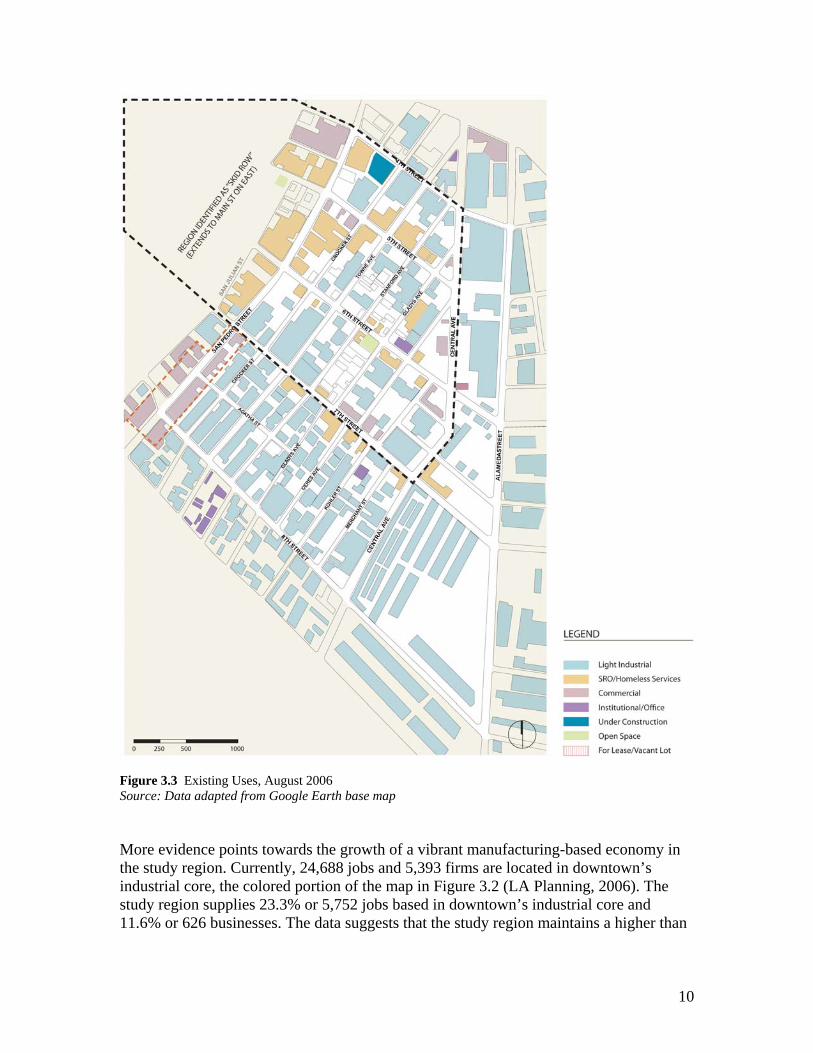
10
Figure 3.3 Existing Uses, August 2006 Source: Data adapted from Google Earth base map More evidence points towards the growth of a vibrant manufacturing-based economy in the study region. Currently, 24,688 jobs and 5,393 firms are located in downtown’s industrial core, the colored portion of the map in Figure 3.2 (LA Planning, 2006). The study region supplies 23.3% or 5,752 jobs based in downtown’s industrial core and 11.6% or 626 businesses. The data suggests that the study region maintains a higher than

11
average employment density than the rest of the downtown industrial core; fewer businesses appear to employ more workers. The study region serves as a regional hub for manufacturing and wholesale industrial firms focused on food production and food related services. Seafood, fresh and frozen produce and cold storage industries dominate the region’s industrial land use (CCEA, 2006). Apparel and wholesale flower industries occupy the south and west borders of the site. Likely to employ less than fifty workers, industries in the study area exemplify the small-scale manufacturers that some scholars envision as the key to an “industrial renaissance” in the U.S. with their flexibility and growth rate. These industries tend to thrive in urban environments because they operate in clusters of “compatible and interrelated production facilities (Loomis, 1997).” Meanwhile, the food production industry cluster experienced an 8.2% job growth between 1997 and 2000. It is the fifth largest industrial employer in Los Angeles. As such, the city recognizes its economic viability and supports its growth. Among the strengths of a food production cluster based in Los Angeles is a large and diverse local market. “The racial, ethnic and cultural diversity of Los Angeles prompts new and expanded ethnic niche markets,” a market for locally produced specialty goods, and a base of cosmopolitan consumers “open to innovation” (Fowler et al, 2004). Changes in household structure with the growth of two-income households and single people boosts the demand for processed food. The success of this industry depends heavily on a strategic location with easy accessibility to road and rail. Currently the high cost of land in Downtown Los Angeles for this industry, like the apparel, furniture and jewelry industries, outweigh the advantages of the proximity to a large labor pool, accessibility to transit and the efficiencies of being near suppliers and customers (Fowler et al, 2004). Problems arise when the street population threatens the sanitary requirements for the food industry that dominates the study region. Furthermore, CCEA executive director, Estela Lopez, believes that industrial operations are wary of locating in the study area because of public safety issues stemming from the concentration of homeless (Lopez, 2006). The Worker Industries in the downtown industrial core offer some of the highest wage jobs for unskilled workers. The food industry in Los Angeles employs over 44,000 workers and expanded 8.2% from 39,804 workers in 1997 to 43,053 in 2000 (City of LA, 2000). In 2003, the average hourly earnings for a worker in the California food processing industry was $13.61. The majority of the workforce in the study area commutes from low-income communities in East and South Los Angeles. Table 3.1 shows that within one mile of the downtown region, 28% of residents are employed by the industrial sector, 79% of individuals over the age of 25 have earned a high school diploma or less education, 38% are living below the poverty line and 39% of housing units do not have access to an automobile. Indeed,

12
according to Sharon Gi of the CRA/LA, 70% of workers in the downtown industrial core identify themselves as transit dependent and therefore likely unable to follow the relocation of their employers (Gi, 2006). Table 3.1 Demographic Analysis of Downtown Industrial Core, 2000 Source: Data from LA Planning, 2006; based on Census 2000 Summary File 3 Within 1 mile of downtown
LA Citywide
Persons employed by manufacturing jobs
28% 13%
Persons over 25 who have a high school diploma or less
79% 51%
Population living below poverty line
38% 22%
Housing units without access to a private automobile
39% 17%
The literature discusses how workers displaced out of the manufacturing sector experienced substantial wage losses after finding new employment in the trade and service sector (Simon, 2004). The average industrial wage was $40,648 while the average retail wage was $19,910 (Planning, 2006). Since certain industries create three times as many secondary jobs as the service sector, some argue that manufacturing jobs keep people off of welfare and stabilize troubled neighborhoods (Loomis, 1997). Others contend that the loss of well-paying jobs in the manufacturing sector has reduced the overall wages of the unskilled and thus increased poverty rates (Bartik, 2005). In summary, this section detailed how the loss of manufacturing industries in downtown’s industrial core likely will result in (1) the loss of multiple thriving industry clusters, (2) a smaller revenue for the city, (3) displaced small-scale manufacturers and their workers, (4) the negative social impacts brought on by a large pool of unemployed unskilled workers, e.g. exacerbated poverty rates in East and South Los Angeles. [3.2] The Street Population and Preservation of Affordable Housing Of the current non-industrial uses in the study area, approximately thirty are residential hotels that accommodate chronically homeless individuals. The previous section discussed the historic roots of downtown Los Angeles’ role as manufacturing hub. These industries were historically seasonal in nature. To accommodate the transient primarily male and single worker populations, single resident occupancy (SRO) hotels were first built along with amenities geared towards single men such as missions, bars, saloons and brothels. In addition to workers, “social misfits” or adventurers seeking a new life and opportunities in the west often settled in downtown Los Angeles simply because it was located at the end of the railline. Numbers increased during the Great Depression when

13
“hobos, migrants in search of work, the unemployable [due to mental incapacity or substance abuse problems]” settled in Central City East for more permanent residence (Spivack, 1998). By the 1960s, the first wave of commercial and industrial growth threatened residential land use. Owners of SROs unable to meet increasingly stringent health and safety codes chose to demolish their hotels rather than upgrade; as a result, 7500 units were lost in a mass displacement. By 1975, policymakers introduced a controversial “containment” approach that attempted to preserve and “stabilize” Skid Row as a neighborhood dominated by very low-income housing and homeless services. Central City East property and business owners formed CCEA in opposition to the policy. By the 1980s, officials focused on the “funding, acquisition, rehabilitation and operation of SRO hotels”, attracting and locating services close to the in-need population, and preserving and expanding industry (Spivack, 1998). The social and economic complexities of Central City East thwarted progress in achieving these goals however. Competition between industrial and both market-rate and low-income residential use continuously loomed. The introduction of the toy and electronics trade industries ten years ago complicated matters as their firms occupied the ground floor space reserved for housing expansion. In addition, policymakers faced legal barriers to expanding the residential base east of San Pedro. By the early 1980s, SROs and shelter facilities exceeded their capacity and the current street population first emerged. Skid Row is now known as the nation’s largest enclave of homeless residents. Today, a chronically homeless individual may reside in one of the 6500 residential units located in Central City East. According to a representative from Skid Row Housing Trust (SRHT), 50% of the individuals living in Skid Row are mentally incapacitated (Baker, 2006). Some of those living on the street are “service-resistant” (i.e., they deny assistance even if it is offered) and voluntarily homeless. More likely, they are not equipped to take the initiative to seek assistance. The supportive housing model backed by many homeless advocates includes in-house social and medical services. Homeless advocates acknowledge that residents of Skid Row are societal outcasts unlike the "workforce" groups targeted by other affordable housing developers. Policymakers have attempted to disperse the concentration of poverty in Skid Row – a legacy of the “containment” policy established in 1975 – to other locations in Los Angeles County. Realistically, NIMBYism has stymied dispersion attempts. Furthermore, a representative from the Skid Row Housing Trust believes that a geographic concentration of homeless housing and services facilitates the provision of services to a population that often is not equipped to take the initiative to seek assistance, or even deny assistance when offered. While he recognizes the benefits of scattering the chronically homeless population, he accepts that improving existing conditions in Skid Row may currently be the only politically feasible strategy. Figure 3.3 shows that the study region falls under the jurisdiction of both the 9th and 14th council districts of Los Angeles. One advocate referred to how the political dissent

14
between council members Jan Perry of the 9th district and Jose Huizar of the 14th district exacerbated homeless issues in Skid Row. While Perry endorses the supportive housing approach, Huizar advocates a previous model that separates housing and services. Those most familiar with Skid Row LA understand that the neighborhood serves as a laboratory for testing out the two distinct strategies. As one blogger writes, the southern portion of the site that falls under the 14th council district is also known as “The Bottoms”, a name that alludes to the region’s reputation as rough even by Skid Row standards. Research also proves that for homeless individuals suffering from mental illness, the supportive housing strategy is the most effective solution (Rosenheck et al, 2003). Its higher cost, however, creates political barriers blocking its implementation, especially for politicians unwilling to prioritize homeless issues.

15
Figure 3.3 Political Boundaries Map Source: Data adapted from City of Los Angeles Department of Public Works website, 2003 and Google Earth, 2006
[3.3] Threats to Industrial Land Use and Very Low Income Residents Currently, the market favors residential and commercial uses over industrial. Both residential and commercial tenants can afford much higher rent and land costs than their manufacturing counterparts. Industrial land is attractive to outside developers because it

16
is cheap to purchase and other uses can significantly “outbid inflating land values” (LA Planning, 2006). Retail uses of industrial land, for instance, can increase the assessed value of the property by over 100% (Fowler et al, 2004). LA’s inner city urban revitalization has spurred the development of both large-scale new construction multi-family housing projects in Little Tokyo and warehouse to artist loft conversions in the Artist District. While the heavily trafficked industrial corridor of Alameda Street forms a natural barrier separating the study region from the Artist District east of Alameda, currently no physical barriers separate the study region from mass redevelopment occurring in Little Tokyo. Market-rate residential conversion primarily threatens industrial use from the northern edges of the study region along 4th Street. Indeed, the first market-rate residential project, Little Tokyo Lofts, in the study area lies at the northern border on the intersection of San Pedro and 4th Street. The Central City East Association (CCEA) represents property owners in the study region; the nonprofit manages the Business Improvement District established in 1999 for the industrial and adjacent toy districts. CCEA asserts that industrial tenants have been fleeing the region long before the threat of residential due to eroding infrastructure, public safety and law enforcement issues stemming from a homeless containment policy, and inevitable “macroeconomic” shifts, i.e., the decline of the manufacturing sector (Lopez, 2006). Moreover, CCEA director Estela Lopez considers the current industrial land use underutilized and the small parcels of the region inadequate for reviving significant industrial activity. CCEA property and business owners support a mixed-use zoning change in Central City East that would permit market-rate residential and commercial uses alongside existing industrial (Lopez, 2006). Homeless and affordable housing advocates voice similar complaints of the underutilized land use in the study area. They, however, worry about market-rate residential developments displacing low-income developments. An advanced stage of gentrification jeopardizes existing industrial tenants when market-rate housing, office and commercial uses raise land values in the neighborhood.
Part 4. Project Goals The previous section detailed the history and development of the study region’s current economic, political and social climate. To summarize, inflating land costs threaten industrial use in downtown’s industrial core while property owners push for more profitable land use conversions. The study region, primarily through a vibrant wholesale trade and manufacturing cluster, employs close to 6000 workers. Gentrification also threatens to displace the homeless population that occupies the study region above 7th Street.

17
Those who support market-rate residential or commercial conversion of industrial land claim that the neighborhood is and has been on the decline, that the study region is underutilized and that industrial use is outdated for its time. The city (who loses revenue with the loss of a manufacturing tax base), homeless advocates, affordable housing advocates, industrial businesses and their workers worry about the haphazard and potentially irresponsible conversion of industrial land. Ultimately, my findings conclude that recycling land to more profitable uses leads to a loss of a major economic base, decreased revenue for the city, and the loss of thousands of jobs. All stakeholder groups concede that the neighborhood requires some form of redevelopment and a grander overall vision. Based on these circumstances, the following goals drive the report’s recommendations described in the next section:
• alleviate blight caused by the street homeless population by housing individuals • retain the jobs and revenue generated from industrial use • fuel new economic growth • advance land use policy that results in the most efficient use of land • provide amenities, sometimes transitional and temporary, for the workers, the public and the homeless
Part 5. Recommendations The sequence of recommendations corresponds roughly to a phasing strategy described more in depth towards the end of the report. [5.1] Implement a flexible approach to land use regulation In efforts to remedy the current inefficiencies in land use, the study region requires a flexible approach to land use regulation. Furthering land use efficiency will aid in achieving all project goals. In addition, land barred by fewer restrictions is more likely to remain attractive to industrial tenants. Planners have implemented Industrial Protection Zones (IPZ) in other cities to prohibit the conversion of industrial land into other uses. Focusing on only regulatory tools like IPZ’s sometimes results in land use inefficiencies because zoning can be out of step with market realities. Critics of Seattle’s IPZ’s contend that major industrial properties remain vacant. Sometimes IPZ’s lead to industrial companies with mobility (such as technology-based businesses or small-scale industrial) relocating outside of protected zones into other areas with fewer restrictions. For those reasons, overzoning of industrial use in Philadelphia and Seattle has hurt economic development (Brion & Associates, 2003). Mixed-use zoning also allows for flexibility and easier adaptation from one obsolete industry to another more promising one (Brion & Associates, 2003). San Francisco

18
policymakers proposed a system evaluating industries depending on wages offered, employment densities, economic viability and necessity for strategic location near the inner city. This criteria helped determine whether to prioritize the preservation of certain industries over others and to pinpoint districts for preferred or protected industrial use. From there, manufacturers were systematically categorized based on environmental performance standards rather than usage. Categorizing based on environmental impact allowed policymakers to determine compatibility with other uses with the intention of a mixed use rezoning based on noise, traffic and pollution impacts. Performance standards also incentivize industries to lessen their environmental impact. For the study area, mixed use rezoning is tentatively prescribed for the Skid Row region of the site with policy designed to incentivize preferred uses, such as low-impact manufacturing and supportive housing for the homeless. Wholesale retailing, a land use compatible with residential uses, dominates this northern half of the site. To prevent gentrification, rent control tools must accompany the rezoning and strict performance standard measures should attempt to keep environmental impact in check (industries are sometimes displaced when residents complain about environmental disruption caused by nearby industrial use). Below 7th Street, planners should prohibit the introduction of residential and commercial development through mandating a transitional protection zone, but allow existing non-industrial uses to remain. [5.2] Incentivize the development of preferred land uses My findings indicated a severe shortage in housing for the homeless. Close to 7,500 SRO units were lost in a mass displacement during the 1960s when SRO owners unable to meet health and safety codes chose to demolish their hotels rather than upgrade. Therefore, policymakers must prioritize the development of both homeless supportive housing along with buildings intended for manufacturing purposes. During my site visit, I noted visual cues that suggested underutilized land use manifested in vacant lots, open-air palette storage and surface parking lots. Figure 5.1 shows that many underused parcels were located in Skid Row. Figure 5.4 highlights an opportunity region characterized by a concentration of vacant lots and lowrise industrial buildings adjacent to existing high rises. The location of existing high rises were noted as they presented an opportunity to introduce unobtrusive vertical forms into the region.

19
Figure 5.1 Opportunity sites Source: Data adapted from Google Earth, 2006

20
Figure 5.2 Examples of Underutilized Land Uses Source: Data adapted from Windows Live Local website, 2006
Figure 5.3 Adding Vertical Development to the Opportunity Region Source: Data adapted from Windows Live Local website, 2006

21
Figure 5.4 Height Study and Proposal for Opportunity Region Source: Data adapted from Google Earth base map Within this opportunity region, planning officials should incentivize development for preferred uses such as wholesale trade, manufacturing, supportive housing and homeless services either through “form-based” policy tools or financial incentives. Relaxing FAR or height restrictions represent two form-based tools, or policy that regulates through manipulating the built environment. The density bonuses achieved through additional FAR or height encourages developers to reinvest in industrial land. It also maximizes use of sought after land. Many of the lowrise one and two-story industrial buildings in the opportunity region are wholesale traders. Wholesale operations have a broader ranger of compatibility with other land uses such as residential.

22
Further investigation is needed for an appropriate highrise residential building typology that concentrates a population of very low-income, mentally incapacitated tenants. The Weingart Center is a highrise SRO notorious for safety issues. One year, its homicide rate exceeded the rate in all of downtown. A vertically integrated structure, perhaps with ground level wholesale trade and supportive housing at upper levels, represents another higher intensity building typology worth exploring for the opportunity region. Currently wholesale trade occupies the ground level of Little Tokyo Lofts. Furthermore, in order to replace lost surface parking, the redevelopment agency may consider investing in a parking structure centrally located in the opportunity region. Manufacturing uses incompatible with residential use shall be moved to sites south of the opportunity region. [5.3] Adopt a holistic approach to retaining small-scale industrial tenants Evaluations of the study region demonstrated that four vibrant clusters of manufacturers occupy the site: apparel, flowers, seafood and produce. Policymakers should formulate a strategy that focuses on attracting and retaining the small-scale industrial tenants that comprise of these manufacturing clusters. Industries locate based on a complex set of reasons beyond protective zoning measures and affordable rent. In order to remain attractive to tenants, policymakers must consider adopting a holistic approach to retain and attract industrial tenants. Some experts posit that small-scale manufacturers emerge as the most promising contemporary industrial tenants. Literature discussing global forces in macroeconomics argues that the role of manufacturing in cities is undergoing a process of restructuring rather than diminishing entirely. Technological advances leave small-scale manufacturers with a competitive advantage to locate in proximity to consumers, suppliers and others involved in the process. Targeting small-scale manufacturers and wholesale traders, the redevelopment agency should consider investing in a centralized economic development support service center (Fowler et al, 2004). All support services should be consolidated into one easily accessible location. Ideally, the center would provide industry-specific support services. In Toronto, a food technology center offers start up food business seminars, staff training, new product development assistance et al. The services should be multilingual to accommodate the diversity of business owners. Further programs may include:
• Wage credits for employing at risk populations, high density employment ratio or businesses that hire locally
• Site assistance programs that help locate appropriate and available properties for prospective industrial tenants. This requires an extensive, consistently updated inventory of existing land use.
23
• Assistance for businesses at an incubator phase. A 2005 study of economic activity in Central City East revealed a surprisingly high rate of apparel businesses starting up and failing (Lee-Kosmont, 2005).
• Building façade improvements • Physical infrastructure improvements. CRA/LA has already prioritized
infrastructure redevelopment in their Central Industrial Redevelopment Project.
[5.4] Alleviate blight caused by homeless through pursuing supportive housing and homeless prevention strategies The National Alliance to End Homelessness (NAEH) undertook an ambitious “Ten Year Plan to End Homeless” campaign that engages all levels of government and all sectors of society. Los Angeles’ size, somewhat convoluted governing structure and overwhelming homeless population explain why it lags behind other major cities in remedying their homeless crisis. Following the supportive housing model, San Francisco and New York City officials recently adopted a “Housing First” strategy that focuses on the provision of permanent housing for homeless before offering services rather than first offering services. As a result, San Francisco’s homeless population dropped 28% between 2002 to 2005. NAEH’s plan advocates approaches that remain sensitive to the diversity of the homeless population. For instance, San Francisco invested in expanding housing options for people with mental illness along with former foster care and homeless youth, and increasing the capacity for substance abuse treatment programs so they can service more homeless (NAEH, 2005). Policymakers may also consider revising regulation to ease supportive housing development. At 6500 units, the number of residential hotel housing units has remained the same in Central City East since the 1980s. Currently, projects that provide for the public good, such as SRO hotels, undergo the same legal procedures as market-rate residential projects. Developers sometimes face even more bureaucratic hassle with an outdated building code that conflates the requirements for target populations. For instance, SRO developers must apply for variances to waive parking requirements for populations clearly not identified as auto-reliant. This creates inefficiencies in the building and construction process that raises the cost of construction. I recommend further investigation on building code amendments that streamline procedures for the production of permanent housing for homeless. An increasing number of women and children are becoming permanent residents of Skid Row. In the past, policymakers discouraged this population from settling in Skid Row through providing services and unit layouts catering towards single men only. They may need to reconsider their stance and address the reality of the current demographic either through accommodating families or establishing formal programs that relocate families to more suitable neighborhoods.

24
Furthermore, the political dissent between Perry and Huizar suggests that policymakers must foster greater consensus between council districts regarding this issue. Follow through may require political restructuring that forces council districts to acquiesce their power to the mayor’s office.
[5.5] Introduce public space and catalyst project to neighborhood My studies revealed that throughout the day, two sizable and underserved populations occupy the site – the industrial workers and the homeless. Policymakers should attempt to provide basic amenities for both. A representative from Skid Row Housing Trust referred to a dearth of public space in the neighborhood to serve the homeless population but also industrial workers during the day. The existing San Julian and Gladys Parks now literally overflow with people. Homeless activity along streets and sidewalks jeopardizes public safety, the safety of workers and sanitary conditions for food manufacturers. The parking lot on 6th Street and San Pedro, highlighted now as a proposed park in Figure 5.6, once served as a temporary site for homeless encampments in the 1980s. I propose that this usage should be formalized by the city through conversion into a public space servicing the homeless. The proposed park should offer low maintenance site furnishings, design that prioritizes safety, and public restroom facilities. The park serves as a temporary measures to remedy problems associated with street activity. Public funds are better spent in homeless prevention programs. The transit study in Figure 5.5 assisted in locating the proposed site for a worker’s park. The map helped me identify transit nodes on site and existing pedestrian-friendly corridors. With 70% of the workers being transit-dependent and many traveling from South Los Angeles, the Metro BlueLine offers a primary linkage between greater Los Angeles and the neighborhood. Flower vendors activate the sidewalk between San Pedro Street between 7th and 8th Street, thereby engaging pedestrians. I recommend cultivating the zone contained within the 5 minute walking radius symbols as a worker-oriented retail node through introducing restaurants and public space.

25
Figure 5.5 Transit Diagram Source: Data adapted from Metro Bus and Metro Rail System Map, 2004 and the Google Earth base map

26
Figure 5.6 Open Space Diagram Source: Data adapted from Google Earth Base Map
As a final phase of redevelopment, I suggest that CRA/LA invest in a catalyst project that establishes a regional destination and a symbolic sense of identity for the study region. One possibility involves the expansion of the proposed economic development support center into a research facility “campus” with a mission to remain at the forefront of manufacturing technology. Perhaps similar in function to an economic thinktank, the facility may aim to formulate long-range visions for each of downtown LA’s local manufacturing clusters. A public element, such as a park, lecture hall or library, can accompany the economic support center targeting business owners and workers. The

27
southern proposed worker park location may serve as an ideal location for the facility; the site is adjacent to an existing institutional use, the 9th Street Elementary School. An iconic architectural style that celebrates the industrial aesthetic of the region is appropriate considering the building’s use. Policymakers might also consider the adaptive reuse of a historic industrial building. The redevelopment agency may partner with CCEA in this project.
Part 6. Summary of Implementation Strategy As policymakers decide on a direction for LA’s industrial land use policy, a citywide moratorium has been placed on the conversion of all industrial land. Meanwhile CRA/LA staff partnered with city planning in the Industrial Land Use Policy Project (ILUPP). ILUPP strives to clarify a vision for the downtown’s industrial core along with the rest of LA’s industrial land. The recommendations in the previous section touched upon the discrete roles of these two agencies. While the redevelopment agency designs and implements programs that harness private moneys towards the public good, the planning department introduces or modifies land use regulation to achieve their goals. Both strategies are needed to execute a feasible work plan. Officials should prioritize earlier phasing items based on the following criteria: (1) feasibility – phase one implements cheaper and less politically charged policy, and (2) the ability for a policy to generate income for the city. More ambitious project goals are reserved until the city builds up equity and a more unified constituency to support all redevelopment efforts. First phase items include passing density bonuses and other financial incentives that cheapen industrial land and supportive housing development. Also, with a substantial portion of the city’s income generated through industrial use -- recall $219.4 million annually -- policymakers should mandate a policy that earmarks part of this revenue directly towards funding redevelopment. We discussed that transitional use zoning will protect industrial use in the study region. Another funding strategy penalizes industrial conversion outside of the study region where conversion is not prohibited, pool the aggregate revenue to a citywide “industrial improvement” pot, and apply the money towards districts requiring the most assistance. The study region no doubt would qualify for aid. Next, officials should prioritize improvements that facilitate economic growth, such as infrastructure improvements or the economic development support center. At this stage, the city may acquire land for open space that targets workers and develop it later as the research facility. These catalyst projects represent the final phase of development.

28
Part 7. Conclusion Urban land values are steadily rising and some consider current inner city industrial land use abandoned, outdated and underutilized. Homeless advocates, affordable housing activists and market-rate housing developers alike advocate higher intensity development of the last remaining tracts of land near city centers. Nevertheless, the haphazard recycling of land leads to a loss of a major economic base, decreased revenue for the city, thousands of unemployed workers and a further displaced homeless population. The situation necessitates a longer-range vision. With the goals of retaining existing sustainable economic activity including the vital employment base, increasing the production of affordable housing in Skid Row, eliminating blight, and enhancing the pedestrian experience for workers, the following recommendations were made:
• enabling a flexible approach to land use regulation through strategic mixed use rezoning; advance policy that results in the most efficient use of land
• incentivizing the development of preferred land uses such as wholesale trade and manufacturing where appropriate, along with supportive housing and homeless service centers
• adopting an approach to retain industrial tenants, namely targeting small-scale manufacturers
• prioritizing the homeless crisis through a “housing first” permanent supportive housing strategy
• introducing public civic space and a catalyst project to strengthen the neighborhood’s identity
The study area presented numerous, possibly unprecedented challenges due to the magnitude of the region’s homeless population. A more feasible implementation plan warrants closer investigation of successful case studies and more thorough knowledge of the local political climate.

29
Citations Baker, Oliver; Representative from Skid Row Housing Trust. Telephone Interview. (August 23, 2006) Behroozi, Cy; Eakin, Terry; Suchman, Diane R.; Todd, James W.. (2001). Urban Infill Housing: Myth and Fact. Urban Land Institute. Brion & Associates with Community Design + Architecture. (2003). White Paper: Literature Review & Case Studies on Industrial Protection Zoning (IPZ) and Recommendations for San Francisco Industrial Rezoning. City of Los Angeles. (2004). Phase 1 Report: Key Industrial Land Use Findings and Issues. Industrial Development Policy Initiative for the City of Los Angeles City of Los Angeles Planning Department. (2006). Downtown Industrial Core, Preliminary Data and Recommendations, December 2006 Fong, Ron; Representative from Little Tokyo Service Center. Telephone Interview. (August 22, 2006) Fowler, M., Freitas, R., Nierenberg, J., Simpson, D.. (2004). Food for Thought: Recommendations to Improve the Relationship between the City of Los Angeles and its Food Processing Sector. The Ralph and Goldy Lewis Center for Regional Policy Studies. Gi, Sharon; Representative from Community Redevelopment Agency of Los Angeles. Personal Interview. (August 18, 2006) Keating, Tim; Representative from Los Angeles River Artists and Business Association. Telephone Interview. (August 17, 2006). La Gange, Maria L., Vincent, Roger. (2006). Seeing Factories as Essential Parts. LA Times. March 13, 2006. Lee-Kosmont Advisory Services. (2005). CCEA – Economic and Fiscal Impact Analysis. February 2005. Loomis, John. (1997). Manufacturing Community. Places 10:1, 1997. Lopez, Estela. (2006). Homeless, Industry, and Lofts Converge in Central City East (Interview with Lopez). The Planning Report Volume 14, No. 7, May 2006. National Alliance to End Homelessness. (2005). Community Snapshot: San Francisco. July 2005 Parker, Cheryl. (1997). Making a Twenty-First Century Neighborhood. Rosenheck R, Kasprow W, Frisman L, Liu-Mares W. (2003). Cost-effectiveness of supported housing for homeless persons with mental illness. Arch Gen Psychiatry, 2003. Smith, Math. (2003). An Industrial Nightmare In San Francisco? SF Weekly. Spivack, Donald R. (1998). History of Skid Row Series, Paper 1. Community Redevelopment Agency. September 15, 1998. Wolff, Goetz. (1998). Low Wage Manufacturing: A Neglected Policy Arena in California. California Policy Options. UCLA School of Public Affairs.

30

31
Appendix
Exhibit 1. Aerial map retrieved from Google Earth in August of 2006. The features of the built environment -- the building footprints, curbs delineating blocks, and street widths -- were approximated based on scanning through the aerial at roughly 200 dpi. The maps generated from the aerial involved using the aerial as a base for tracing and highlighting these features using the vector-based graphics program, Adobe Illustrator.

32

Appendix: Notable Properties
Little Tokyo Lofts
Weingart Center
Rossmore Hotel (SRO Rehabilitation Project)
Catch 21 Seafood Restaurant
Gladys Park Flower Markets

Appendix: Notable Properties
Smaller-scale industrial building (below 7th Street)
Inner City Arts
Seventh & Central Produce Market
Los Angeles Wholesale Produce MarketSmaller-scale industrial building (below 7th Street)