industry marketing gary cooper product development ibm software group tivoli...
TRANSCRIPT

Ron Wallace Ron Wallace –– Industry MarketingIndustry MarketingGary Cooper Product DevelopmentGary Cooper Product Development
IBM Software GroupIBM Software GroupTivoli MaximoTivoli Maximo
Spatially Enabling Enterprise Asset ManagementSpatially Enabling Enterprise Asset Management Using Using ArcGISArcGIS ServerServer

22
AgendaAgenda
•• Enterprise Asset Management and GISEnterprise Asset Management and GIS•• Value of Spatially enabling Enterprise ApplicationsValue of Spatially enabling Enterprise Applications•• IBM IBM –– ESRI RelationshipESRI Relationship•• How How ArcGISArcGIS Server supports Enterprise ApplicationsServer supports Enterprise Applications•• Product DevelopmentProduct Development•• QuestionsQuestions
33
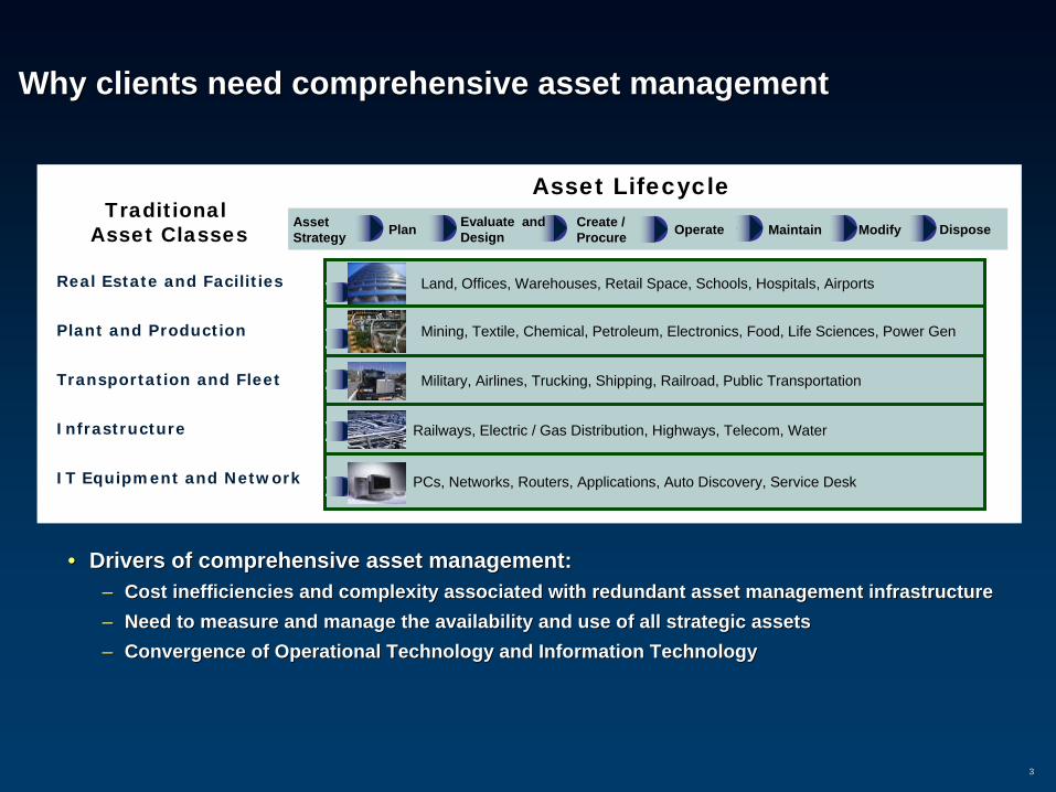
Why clients need comprehensive asset managementWhy clients need comprehensive asset management
•• Drivers of comprehensive asset management:Drivers of comprehensive asset management:–– Cost inefficiencies and complexity associated with redundant assCost inefficiencies and complexity associated with redundant asset management infrastructureet management infrastructure–– Need to measure and manage the availability and use of all stratNeed to measure and manage the availability and use of all strategic assetsegic assets–– Convergence of Operational Technology and Information TechnologyConvergence of Operational Technology and Information Technology
Railways, Electric / Gas Distribution, Highways, Telecom, Water
AssetStrategy Plan Evaluate and
DesignCreate / Procure Operate Maintain Modify Dispose
Asset LifecycleTraditional
Asset Classes
Plant and Production
Real Estate and Facilities
Transportation and Fleet
Infrastructure
Land, Offices, Warehouses, Retail Space, Schools, Hospitals, Airports
Mining, Textile, Chemical, Petroleum, Electronics, Food, Life Sciences, Power Gen
Military, Airlines, Trucking, Shipping, Railroad, Public Transportation
IT Equipment and Network PCs, Networks, Routers, Applications, Auto Discovery, Service Desk

44
Maps and GeoMaps and Geo--coded Information is Pervasivecoded Information is Pervasive

55
Water Resources
Roads/Infrastructure
Demographics
Land Use/Land Cover
Environmental
Considerations
Imagery
• Geo-Referencing• Map Overlay• Spatial Analysis• Visualization
… integrating measurements and disciplines
Topographic Data
Geographic Information Systems (GIS) Geographic Information Systems (GIS) Integrates DataIntegrates Data

6
Population . . . . . . . . . . . . . . . . . . . . . . . . . . . . . . . . . . . 281,000Metro census (2000) . . . . . . . . . . . . . . . . . . . . . . . . . . . 380,000Adopted expenditure budget FY 2006-07. . . . . . . . . . $566 MTotal full time City employees . . . . . . . . . . . . . . . . . . 2,000+Utility accounts (approximate) . . . . . . . . . . . . . . . . . . 80,000
City of Corpus Christi, Texas
CITY UTILITIES
• 174 MGD Water production plant• 6 Wastewater Treatment Plants• 1500+ miles water mains• 1250+ miles wastewater mains• Gas distribution city owned/operated
City Wide Response:Competition from Privatization

7
City of Corpus Christi, Texas

8
Older area
Newer Area
Each Customer’s Work Order has a mappable location codeenabling spatial analysis using our MAXIMO- GIS interface
Example of Locations of Wastewater Back-up Calls
City Wide Response:Develop tool to spatially analyze work done or needed
Improved decision making based on visualization and themematic mapping.
–Internal Service departments understanding service level targets, monitoring trends & making needed tactical adjustments
–Visualizing strategic implications of work & impact to others
–Fewer “work silos” and a “flatter” organization with a multi-skilled workforce

9
Common Work Queue• Supervisors have clear ownership of work in a geographic
area - while increasing their ability to transfer and receive work from others.
• Supervisors can prioritize their work more effectively– Grouping work by due date– Grouping leaks by grade– Filtering tasks to see Mandated work
• Construction & Maintain can communicate through buffers of various types– C/S Construction - Cost avoidance of maintenance work– Identifying mandated maintenance work on pending street resurfacing
projects.
Maximo CIS Others
Primary Assignment Rules
Secondary Assignment Rules

10
Consolidated View
East 42nd St
ForsterA
ve
MeterChanges
LEAKS
Work Orders
CIS
Maximo
LMS
Streets
CustomerLocations
CIS
Multiple Data Sources
Graphical & Tabular Views

11
Travel Distance - Within n feet in both directions from the primary job
St
n Ave
200’ 300’
200’200’
500’
Tagalong Determination

1212
Honolulu Board of Water SupplyHonolulu Board of Water Supply
•• Serves One Million Customers On Serves One Million Customers On Oahu, & Provides SupportOahu, & Provides Support Services To KauaiServices To Kauai
•• Among the 10 Largest Water Utilities in Among the 10 Largest Water Utilities in USUS
•• Primary Function is to Provide Municipal Primary Function is to Provide Municipal Water and Fire Protection for OahuWater and Fire Protection for Oahu
Treat 50 Billion Gallons of Water/ Year110 Reservoirs and 170 Water Sources1,900 Miles of Pipeline155,000 Metered Connections

1313
Integration Accommodates Sharing Asset Data Across Multiple Integration Accommodates Sharing Asset Data Across Multiple Enterprise SystemsEnterprise Systems
SCADASCADA GISGISMaximoMaximo CISCIS
RuntimePressureLevelsSpeed
ConditionRepair HistoryMaintenanceCrews
Location CustomerBillingMeter ReadingRates

1414
Honolulu Board Water SupplyHonolulu Board Water Supply
Clicking the “Map It”
button brings up the GIS
map with the work
highlighted

1515
US Marine Corp and Naval FacilitiesUS Marine Corp and Naval Facilities
Work Order Summary
Facility Summary

1616
Chelan County Public Utility DistrictChelan County Public Utility District
•• MAXIMOMAXIMO•• Work OrdersWork Orders•• InventoryInventory•• Detailed Equipment informationDetailed Equipment information
–– Distribution TransformersDistribution Transformers–– Line ApparatusLine Apparatus
•• ArcGISArcGIS•• Location dataLocation data•• TwoTwo--way integrationway integration•• Improved planning & schedulingImproved planning & scheduling•• Failure analysis MapsFailure analysis Maps
The biggest benefit of integrating the systems was in the work management arena. All work orders developed in the EAM systems were tagged with a GIS location, typically a map page and a location ID. This made it possible to better plan and schedule work by geographic area. It also allowed the district to produce maps for failure analysis and required maintenance work.

1717
Market Trend From IDCMarket Trend From IDC
•• IDC IDC –– Extending GIS to Enterprise Extending GIS to Enterprise ApplicationApplication
•• GET (Geospatial Enabling Technologies)GET (Geospatial Enabling Technologies)
–– Spatial Context Spatial Context –– location increases location increases the value of datathe value of data
–– Quantification/measurement Quantification/measurement –– routing, network analysisrouting, network analysis
–– Modeling Modeling –– look for trends, predict look for trends, predict occurrenceoccurrence
–– Geographical analysis Geographical analysis -- proximityproximity
–– Reference Reference –– relate data beyond the relate data beyond the boundary of the enterpriseboundary of the enterprise
–– Visualization Visualization –– Thematic mappingThematic mapping

1818
Value of Spatial Enabling EAMValue of Spatial Enabling EAM
•• Visualization Visualization –– assets, locations, assets, locations, wowo’’ss srsr’’ss
supports visual business analysissupports visual business analysis•• Spatial Context Spatial Context
–– location provides contexts that location provides contexts that makes information more makes information more meaningfulmeaningful
•• ReferenceReference–– group, cluster or categorize group, cluster or categorize
related information, reference related information, reference related feature class details and related feature class details and infrastructureinfrastructure
•• Quantification / Measurement Quantification / Measurement –– distance, physical relationship distance, physical relationship
between objects, proximity between objects, proximity measures, obstacles and available measures, obstacles and available routesroutes
•• Modeling Modeling –– trends, variation, patternstrends, variation, patterns
Older area
Newer AreaExample of Locations of
Wastewater Back-up Calls

1919
Why is IBM Working With ESRI?Why is IBM Working With ESRI?
–– Market share leaderMarket share leader–– Embraces standardsEmbraces standards--based technology allowing embedded components in based technology allowing embedded components in
enterprise applicationsenterprise applications
Develop Generic GIS Components . . .Develop Generic GIS Components . . .
MobileMobile
EmbeddedEmbeddedArcGIS Frameworks
ArcGIS Frameworks
DesktopDesktop
ArcObjectsArcObjects
…and deploy …and deploy them in multiple them in multiple
productsproducts
ServerServer
ESRI Product StrategyESRI Product Strategy
•• Geographic Information System (GIS) Geographic Information System (GIS) Software And ServicesSoftware And Services
•• 37 Years In Business, Privately Held37 Years In Business, Privately Held•• 300,000 Client Organizations, > 1M Users300,000 Client Organizations, > 1M Users•• > 84% U.S. Public Sector Market> 84% U.S. Public Sector Market•• > 50% Of U.S. Utility Market> 50% Of U.S. Utility Market•• Measurable Footprint In 50 Industry SectorsMeasurable Footprint In 50 Industry Sectors•• MultiMulti--channel Sales Organizationchannel Sales Organization•• Largest Annual Event; User Conference, Largest Annual Event; User Conference,
15,000+ Attendees15,000+ Attendees•• Synergy With IBM In Technology, Business Synergy With IBM In Technology, Business
Outlook, ValuesOutlook, Values

2020
IBM & ESRI Strategic AllianceIBM & ESRI Strategic Alliance
Global Strategic Alliance Global Strategic Alliance Serves growing market for Serves growing market for
enterprise Geographic enterprise Geographic Information System (GIS) Information System (GIS) solutions solutions
ESRI provides GIS ESRI provides GIS software technology software technology enabled on IBM enabled on IBM infrastructure products infrastructure products
Premier PW Member Premier PW Member IBM Maximo team is IBM Maximo team is
engaged with IBM ESRI engaged with IBM ESRI alliance teamalliance team
Application Server
BusinessIntegrator
Mainframe
CRW/ERP
Rational Spatial
IntegrationAdapter
ApplicationDeveloper
Workplace
EveryplaceAccess
Portal
WEA LASAdapters
ArcWebServices
Portlets
JavaClient
WebBrowser
WebService
and Image Catalog
System x, p, z, BladeCenter, TotalStorage
ArcGIS Image Server
Open APIs
Web MappingApplications
ArcGISDesktop
ArcGISMobile
Spatial DataManagement
Visualization(Mapping)
SpatialAnalysisArcGIS Server
Studio

2121
History: ESRI & MRO SoftwareHistory: ESRI & MRO Software
MRO Software and ESRI formalized alliance in 2005MRO Software and ESRI formalized alliance in 2005Spatial enablement of Maximo stems joint effort to develop Spatial enablement of Maximo stems joint effort to develop and market spatially enabled asset and service management and market spatially enabled asset and service management solutions. solutions. Engaged at all levels of ESRIEngaged at all levels of ESRI
–– CEO support / engagementCEO support / engagement–– Development / Services supporting IBM Maximo Spatial Development / Services supporting IBM Maximo Spatial
and current active research projectsand current active research projects–– Working with marketing / sales / industry marketing on go Working with marketing / sales / industry marketing on go
to market activitiesto market activitiesWorking with latest ESRI technologyWorking with latest ESRI technologyAwardsAwards
–– New Business Partner of the Year 2007New Business Partner of the Year 2007

Gary Cooper Product DevelopmentGary Cooper Product DevelopmentIBM Software GroupIBM Software Group
Tivoli MaximoTivoli Maximo
Development PerspectiveDevelopment Perspective

2323
Web ApplicationWeb Application
ArcObjectsProxies
Java/.NET
Objects
Web Application Server
Web ApplicationWeb Application
ArcObjectsProxies
Java/.NET
Objects
Web Application Server
GIS Server GIS Server –– What is the right architectureWhat is the right architecture
Server Object
Manager
BrowserBrowser
Server Object Containers
GIS Server
ArcGIS DesktopArcGIS Desktop
BrowserBrowser
Internet
ArcGIS EngineArcGIS Engine
Server Object Containers

2424
ActionAction
DecisionDecisionMakingMaking
ModelingModeling
AnalyzeAnalyze
MeasureMeasure
Guiding Human Guiding Human ActivitiesActivities
PlanningPlanning
. . . Connects Disciplines, Departments, Organizations. . . Connects Disciplines, Departments, Organizations
Does it support the right functionality?Does it support the right functionality?

2525
Does it support diversity in data sourcesDoes it support diversity in data sources
. . . And Making It All Accessible. . . And Making It All Accessible
Managing Complexity . . .Managing Complexity . . .
GIS
AuthorAuthor
ServeServe
UseUse

2626
What are we doing with GIS?What are we doing with GIS?
Spatially enabling Work ManagementSpatially enabling Work Management•• Embedding Embedding ArcGISArcGIS Server 9.2 technology stack in the UIServer 9.2 technology stack in the UI•• Powerful Java Powerful Java ArcObjectsArcObjects provide capabilities formerly found on only the desktopprovide capabilities formerly found on only the desktop•• Dynamic Dynamic –– not staticnot static•• Visualization of data Visualization of data –– a map as a reporta map as a report•• GeocodingGeocoding, tracing networks, routing, simple editing, tracing networks, routing, simple editing•• Elimination of data duplicationElimination of data duplication•• Leverage both technologiesLeverage both technologies
Spatially enabled Work Management should allows users to visualize all assetsand work in their geospatial context to optimizeresources and decisions

2727
Why Is This Innovative?Why Is This Innovative?
•• Full strength of GIS spatial analyses can be exposedFull strength of GIS spatial analyses can be exposed–– SpatiallySpatially--enable executiveenable executive--level cost/benefit analyses level cost/benefit analyses –– Right access to data drives efficient processes throughout orgRight access to data drives efficient processes throughout org–– Model both outside plant and inside plant in single systemModel both outside plant and inside plant in single system
•• Any entity can be spatiallyAny entity can be spatially--enabled, not just assets.enabled, not just assets.–– Service Request, Locations, Crews, People, Work Orders, Tools, MService Request, Locations, Crews, People, Work Orders, Tools, Materials, Laboraterials, Labor
•• All asset types can be spatiallyAll asset types can be spatially--enabled, not just points.enabled, not just points.–– Points: Pole, Hydrant, Meter, Sign, Transformer, House, ComputerPoints: Pole, Hydrant, Meter, Sign, Transformer, House, Computer–– Linear: Roads, Rail, Pipelines, Linear: Roads, Rail, Pipelines, PowerlinesPowerlines, Communication networks, Communication networks–– Area: RightsArea: Rights--ofof--way, Buildings, Roofs, Service Areas, Campus, Officeway, Buildings, Roofs, Service Areas, Campus, Office
•• Leveraging the latest ESRI technology Leveraging the latest ESRI technology –– Early adopter of serverEarly adopter of server--based GISbased GIS–– No other asset management vendors are using this approachNo other asset management vendors are using this approach–– Others use static Others use static ArcIMSArcIMS published datapublished data

2828
Combined Architecture Combined Architecture –– GIS and Work ManagementGIS and Work Management
EAM SPATIAL
ESRI – ArcMap Desktop
Application Editor
WMS ApplicationBusiness Components
(SDE) Spatial Database Engine
ESRIArcGIS Server 9.2 ArcObjects
Web Server (HTTP)
J2EE Application Server
Web ControlsTables, Fields, Tabs
Java ADF Web ControlsMap, TOC, Toolbar, Task
GIS

2929
Extend Schema & LinkageExtend Schema & Linkage
SHAPESHAPE OBJECTIDOBJECTID NAMENAME CREATEINMAXIMOCREATEINMAXIMO MXASSETUIDMXASSETUID ……
133133 43214321 Main St.Main St. YESYES 1234567812345678
ROADS – GIS Feature Class Business Table
ASSETNUMASSETNUM LOCATIONLOCATION DESCRIPTIONDESCRIPTION FEATURECLASSNAMEFEATURECLASSNAME MXASSETUIDMXASSETUID ……
10011001 Main St.Main St. ROADSROADS 1234567812345678
ASSET – MXES
LOCNUMLOCNUM DESCRIPTIONDESCRIPTION FEATURECLASSNAMEFEATURECLASSNAME MXLOCATIONSIDMXLOCATIONSID ……
L2003L2003 PlaygroundPlayground PARKPARK 0992233445609922334456
LOCATION - MXES
SHAPESHAPE OBJECTIDOBJECTID NAMENAME CREATEINMAXIMOCREATEINMAXIMO MXLOCATIONSIDMXLOCATIONSID ……
245245 12341234 PlaygroundPlayground YESYES 0992233445609922334456
PARK – GIS Feature Class Business Table
ASSETS
• Keep it simple

3030
ArcGISArcGIS Server InnovationServer Innovation
•• Innovative User of External Data SourcesInnovative User of External Data Sources–– Remote Spatial Databases Remote Spatial Databases –– connect in connect in ArcCatalogArcCatalog–– External data sources can provide themes that overlay the producExternal data sources can provide themes that overlay the production layerstion layers–– GPS(AVL) feeds from provider to track resources, assets, tools.GPS(AVL) feeds from provider to track resources, assets, tools.–– Any spatial data not maintained internally is a potential sourceAny spatial data not maintained internally is a potential source..–– FEMA flood planes, evacuation routes, census dataFEMA flood planes, evacuation routes, census data–– Easily integrated to map document simply by creating a connectioEasily integrated to map document simply by creating a connection. n. –– Any web services compatible with ESRI data formatsAny web services compatible with ESRI data formats

3131
Architecture Design TiersArchitecture Design Tiers
Web BrowserJavaScript
Layer
J2EEWeb Layer
J2EEService Layer
Data StorageLayer
FeatureClassTables
SingleDatabase
ApplicationTables
MultipleDatabases
Application TablesFeature Class Tables
ApplicationBusinessObjects
ApplicationJavaScript
Library
Extensions forDispatchingGIS Events
ESRI Web ADFJavaScript
Library
Extensions forHandling & Dispatching
Application Events
SDE - Spatial Database Engine
ESRIArcObjects
GISMeta Data
RegistrationValidation
Application UIFramework
Presentation, Beans, Controls, Designer
Map ControlImplementationEvent Queue, Meta Data, State, Actions
ESRI Web ADFJSF Controls
Beans, Tasks,Tools, XSL
JSF FrameworkTasks, ToolsEvent Handlers

What will it look like?What will it look like?

3333
Display Assets on a Map Display Assets on a Map –– Breakers at the Breakers at the SubStationSubStation

3434
Views presenting geographical diversity of assetsViews presenting geographical diversity of assets

3535
Address Search for Map NavigationAddress Search for Map Navigation

3636
Access Image data (internal or external)Access Image data (internal or external)

3737
Editing GIS Data Editing GIS Data
•• Create, Modify, Link GIS featuresCreate, Modify, Link GIS features
–– Should work management users edit GIS Should work management users edit GIS data? data?
•• Maybe?Maybe?
•• Sometimes?Sometimes?
•• Never?Never?
–– What about work orders?What about work orders?•• Feature is owned by work managementFeature is owned by work management
•• All GIS consumers should see work orders All GIS consumers should see work orders immediately. (GIS users, CSRimmediately. (GIS users, CSR’’s, Public)s, Public)
–– Expose defined work to the Enterprise Expose defined work to the Enterprise and Publicand Public

3838
Visualize Proximity NEZ (No Entry Zones)Visualize Proximity NEZ (No Entry Zones)
No Entry Zone
Alarm sounds when emplyee enters defined Zone here
• GIS works anywhere
• Define No Entry Zones and monitor zone boundary
• Supports safety and regulatory compliance at any work location
• RF (Wi-Fi, Broadband cellular) and RFID make this possible
• Work Assignment by proximity
• Right resource at the right place at the right time.

3939
SummarySummary
• As Google brought maps, directions, and other location based services to the consumer, we have brought the full power of geospatial technology to the global enterprise.
• As many of our industry leading customers have directed us, GIS functionality within an Enterprise Application is core to the business and essential in optimizing operations.
• Now IT staffs and system integrators can focus on creating the business processes and solutions for the company instead of resources being spent on the nuts and bolts of integration.

4040