information resource management administration, a … · web viewgeographic information systems...
TRANSCRIPT
Information Resource Management AdministrationGeographic Information Systems
Addressing, Address Matching and Gecoding Guidelines
Background
This document is a direct result of recommendations put forth by The Maryland State Government Geographic Information Coordinating Committee (MSGIC). The Maryland Department of Health and Mental Hygiene (DHMH) has adopted specific recommends as guidelines. DHMH are requested to adhere the guidelines as it relate to Addressing, Address Matching and Geocoding. The report has been modified to reflect only those recommendations that would impact DHMD directly. Use of this report for DHMH purposes was approved by MIGIC representatives.
About The State Government Geographic Coordinating Committee ( MSGIC ) and it recommendations
The Maryland State Government Geographic Information Coordinating Committee (MSGIC) serves as the focal point for the coordination of State agency GIS activities. MSGIC supports the development of geographic data sets that are useful to multiple State agency purposes. MSGIC also recognizes that it is individual State agencies that are principally responsible for developing and maintaining the specific data sets for spatial analysis and display.
The purpose of this report is to make recommendations on addressing standards which will enhance the ability to use geographic information systems to determine the coordinate location of street address information maintained in agency databases.
Street addresses are one of the most commonly used references for locating information. Many agencies and organizations in both the public and private sector maintain databases in which the street address is part of the record. Using MSGIC's infrastructure base maps the x, y coordinate location of an address in a database can be determined (i.e., geocoded or address matched).
The geocoded address records are used with geographic information systems software to assist in problem solving. For example, 911 calls for service can be located on a digital street map as an aid in dispatching, school bus routes can be determined based on the location of students and health concerns (e.g., incidents of lead paint poisoning) can be spatially displayed to aid in developing abatement strategies.
.
Guidelines on Addressing
IRMA encourages using elements of the U.S. Postal Service's addressing standards where there is an interest in
using computer mapping software to identify the geographic location of records (e.g., client, service provider, facility or incident records) that contain an address.
Valid database addresses for address matching and geocoding have the following elements: Street Number, Prefix Directional, Street Name, Street Type, Suffix Directional, Post Office (City/Town), State, ZIP and County. (See Attachments I and II).
IRAM encourages units seeking to develop an in-house address matching and geocoding capability or contacting such services from outside vendors should adhere to the following:
In determining requirements for computer hardware and address matching software, DHMH units should seek the advice and guidance from Irma’s GIS Technical Assistance unit
In preparing database files for address matching, DHMH units should follow the guidelines for standardization of address information (see Attachment III).
In meeting their needs for a geographic file and digital street map, DHMH units should acquire and use the MSGIC supported MDlandbase files and accompanying census boundary files (see Attachment IV) rather than similar proprietary files sold commercially.
I. Why Adopt Standardized Addresses
From IRMA, s perspective, the use of standardized addressing enhances the ability to use a geographic file (e.g., TIGER/line or MDlandbase, see Attachment IV) to determine the coordinate location of an address record in a database file. This is called address matching or geocoding.Standardized addressing in a database file is also of benefit where the address information serves as the basis for generating mail pieces. The use of standardized addresses that meet postal format requirements result in improved mail processing and delivery, reduced undeliverable-as-addressed mail and lowered costs associated with mailing. 1
The adoption of standardized addressing benefits activities related to both geocoding and mailing. In determining whether to adopt or improve address standards, DHMH units should consider the benefits from both these activities.
II. How Address Matching Works
Addresses are one of the most commonly used references for locating information. Many agencies and organizations maintain extensive databases in which the street address is part of the record. Address matching or geocoding is the process by which the address fields in the database are assigned an x, y coordinate location (typically in latitude and longitude or State plane coordinates).Address matching is usually an option or module incorporated into commercially available mapping software. The geocoding software compares the address of each record in the database with a geographic file that references the address to its location on a digital street map. When a match is found, the x, y geographic coordinates are assigned to the address of the database record (see Diagram 1). Additionally, if the street segments in the geographic file have been assigned their census geographic area code (i.e., census tract, block group and block) they will also be assigned to the database record. 2
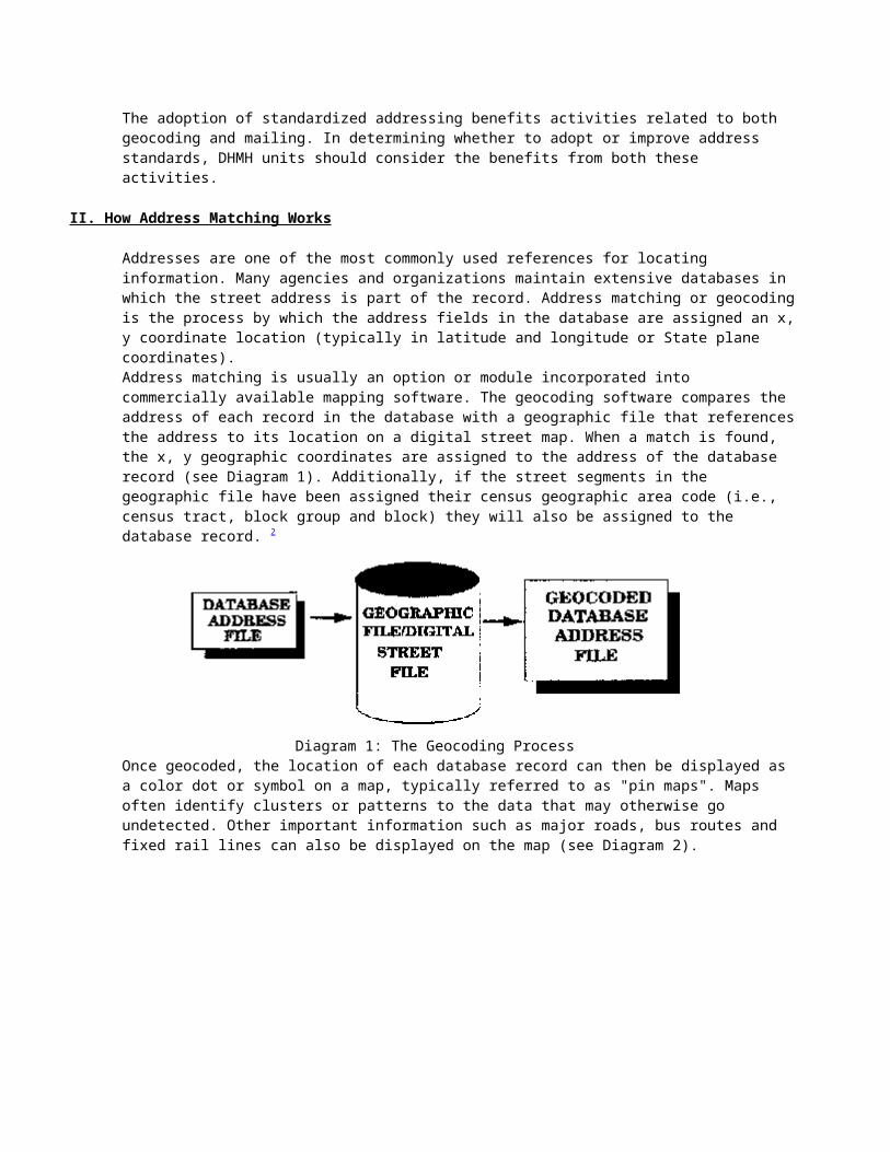
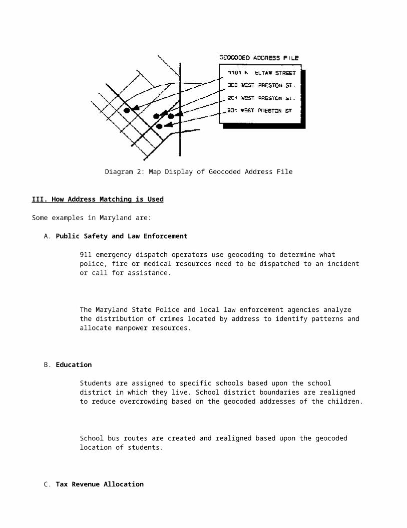
Diagram 1: The Geocoding ProcessOnce geocoded, the location of each database record can then be displayed as a color dot or symbol on a map, typically referred to as "pin maps". Maps often identify clusters or patterns to the data that may otherwise go undetected. Other important information such as major roads, bus routes and fixed rail lines can also be displayed on the map (see Diagram 2).
Diagram 2: Map Display of Geocoded Address File
III. How Address Matching is Used
Some examples in Maryland are:
A. Public Safety and Law Enforcement
911 emergency dispatch operators use geocoding to determine what police, fire or medical resources need to be dispatched to an incident or call for assistance.
The Maryland State Police and local law enforcement agencies analyze the distribution of crimes located by address to identify patterns and allocate manpower resources.
B. Education
Students are assigned to specific schools based upon the school district in which they live. School district boundaries are realigned to reduce overcrowding based on the geocoded addresses of the children.
School bus routes are created and realigned based upon the geocoded location of students.
C. Tax Revenue Allocation
The Comptroller's Office uses address matching and geocoding to properly distribute the piggyback income tax to the county and/or municipality in which the taxpayer lived during the tax
year.
The Department of Assessments and Taxation uses address matching to map the distribution of property assessment appeals to identify clusters or patterns.
D. Health and Environment
The Department of the Environment uses address matching to map the distribution of children tested for blood lead poisoning in Maryland. The specific locations where the problem is prevalent are identified to assist in developing strategies to address the health issue.
E. Delivery of Products and Services
Businesses use address matching to identify the exact location of existing customers. New offices or distribution centers are located in relation to customers.
Delivery trucks are efficiently routed from one address to another along a delivery route once the address of each stop has been located.
IV. What is Required for Good Addressing Matching
A. Database File Address Requirements
The database file you wish to address match or geocode must contain good address information. The addresses that appear in your database must be complete and follow commonly accepted standards in order to achieve a high match rate with the geographic file (i.e. the digital street map).
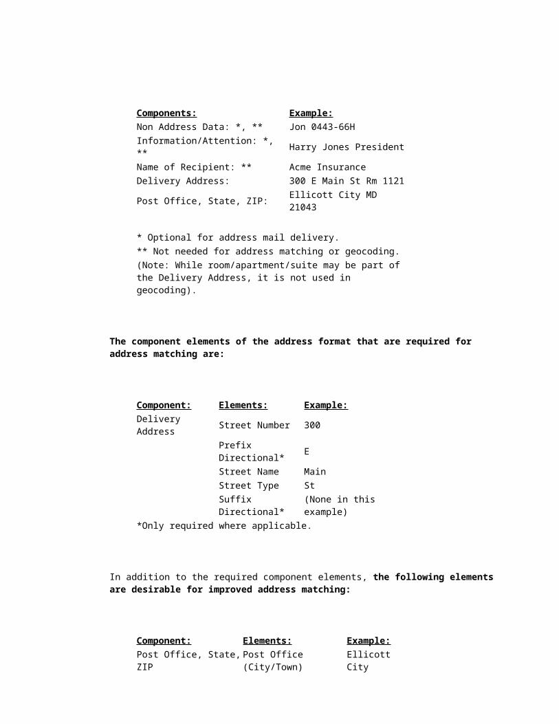
The addressing standards prescribed by the U.S. Postal Service for addressing mail are inclusive of the requirements for good address matching (see Attachment I for a more complete discussion of U.S. Postal Service standards for addressing mail). Listed below are the recommended postal service address components.
Components: Example:Non Address Data: *, ** Jon 0443-66HInformation/Attention: *, ** Harry Jones PresidentName of Recipient: ** Acme InsuranceDelivery Address: 300 E Main St Rm 1121Post Office, State, ZIP: Ellicott City MD 21043 * Optional for address mail delivery.** Not needed for address matching or geocoding.
(Note: While room/apartment/suite may be part of the Delivery Address, it is not used in geocoding).
The component elements of the address format that are required for address matching are:
Component: Elements: Example:Delivery Address Street Number 300 Prefix Directional* E Street Name Main Street Type St Suffix Directional* (None in this example)*Only required where applicable.
In addition to the required component elements, the following elements are desirable for improved address matching:
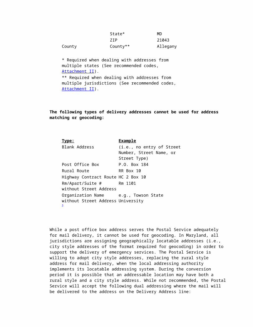
Component: Elements: Example:Post Office, State, ZIP Post Office (City/Town) Ellicott City State* MD ZIP 21043County County** Allegany * Required when dealing with addresses from multiple states (See recommended codes, Attachment II).** Required when dealing with addresses from multiple jurisdictions (See recommended codes, Attachment II).
The following types of delivery addresses cannot be used for address matching or geocoding:
Type: ExampleBlank Address (i.e., no entry of Street Number,
Street Name, or Street Type)Post Office Box P.O. Box 184Rural Route RR Box 10Highway Contract Route HC 2 Box 10Rm/Apart/Suite # without Street Address
Rm 1101
Organization Name without Street Address 3
e.g., Towson State University
While a post office box address serves the Postal Service adequately for mail delivery, it cannot be used for geocoding. In Maryland, all jurisdictions are assigning geographically locatable addresses (i.e., city style addresses of the format required for geocoding) in order to support the delivery of emergency services. The Postal Service is willing to adopt city style addresses, replacing the rural style address for mail delivery, when the local addressing authority implements its locatable addressing system. During the conversion period it is possible that an addressable location may have both a rural style and a city style address. While not recommended, the Postal Service will accept the following dual addressing where the mail will be delivered to the address on the Delivery Address line:
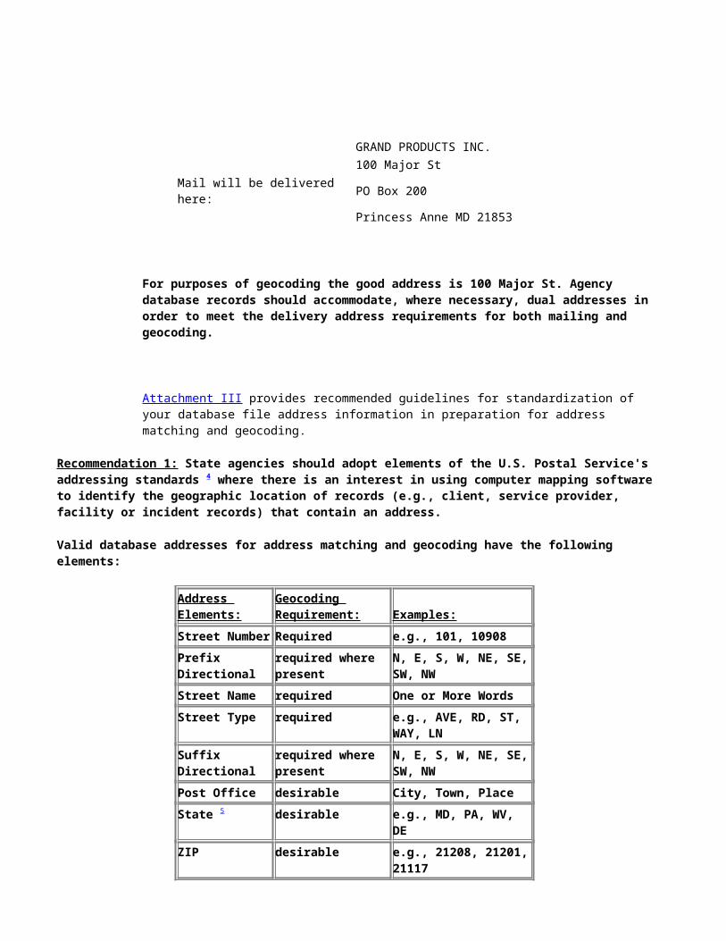
GRAND PRODUCTS INC. 100 Major StMail will be delivered here: PO Box 200 Princess Anne MD 21853
For purposes of geocoding the good address is 100 Major St. Agency database records should accommodate, where necessary, dual addresses in order to meet the delivery address requirements for both mailing and geocoding.
Attachment III provides recommended guidelines for standardization of your database file address information in preparation for address matching and geocoding.
Recommendation 1: State agencies should adopt elements of the U.S. Postal Service's addressing standards 4 where there is an interest in using computer mapping software to identify the geographic location of records (e.g., client, service provider, facility or incident records) that contain an address.
Valid database addresses for address matching and geocoding have the following elements:
Address Elements:
Geocoding Requirement: Examples:
Street Number Required e.g., 101, 10908Prefix Directional
required where present
N, E, S, W, NE, SE, SW, NW
Street Name required One or More WordsStreet Type required e.g., AVE, RD, ST, WAY,
LNSuffix Directional
required where present
N, E, S, W, NE, SE, SW, NW
Post Office desirable City, Town, PlaceState 5 desirable e.g., MD, PA, WV, DEZIP desirable e.g., 21208, 21201, 21117County 5 desirable 23 Counties and
Baltimore City
B. Geographic File Address Requirements
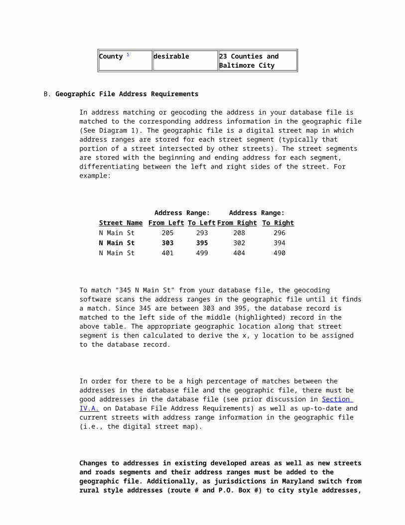
In address matching or geocoding the address in your database file is matched to the corresponding address information in the geographic file (See Diagram 1). The geographic file is a digital street map in which address ranges are stored for each street segment (typically that portion of a street intersected by other streets). The street segments are stored with the beginning and ending address for each segment, differentiating between the left and right sides of the street. For example:
Address Range: Address Range:Street Name From Left To Left From Right To RightN Main St 205 293 208 296N Main St 303 395 302 394N Main St 401 499 404 490
To match "345 N Main St" from your database file, the geocoding software scans the address ranges in the geographic file until it finds a match. Since 345 are between 303 and 395, the database record is matched to the left side of the middle (highlighted) record in the above table. The appropriate geographic location along that street segment is then calculated to derive the x, y location to be assigned to the database record.
In order for there to be a high percentage of matches between the addresses in the database file and the geographic file, there must be good addresses in the database file (see prior discussion in Section IV.A. on Database File Address Requirements) as well as up-to-date and current streets with address range information in the geographic file (i.e., the digital street map).
Changes to addresses in existing developed areas as well as new streets and roads segments and their address ranges must be added to the geographic file. Additionally, as jurisdictions in Maryland switch from rural style addresses (route # and P.O. Box #) to city style addresses, the city style addresses must be incorporated into the geographic file since only city style addresses can be successfully geocoded.
MSGIC, through its Digital Infrastructure Base Maps, is addressing the need to develop and maintain an up-to-date geographic file and digital street map.
The MSGIC Digital Infrastructure Base Maps consist of a road/address layer and digitized parcel x, y reference points. There are actually five separate components which go into their creation: (1) State Highway Administration road grid maps; (2) U.S. Census Bureau TIGER/Line files; (3) "conflated" SHA/TIGER (MDlandbase) files which combine the cartographic detail of the SHA
road maps with TIGER/Line street segment and address range information; (4) scanned, raster images of the parcel maps with vector updates for new parcels; and (5) digitized parcel x, y reference points linked to the parcel database. The production of these base layers is a cooperative effort of the State Highway Administration, Bell Atlantic, the Maryland Office of Planning and the Department of Assessments and Taxation. The data has an overall map accuracy of 1:24,000. Components (2), (3) and (4) are described in more detail below and are essential to providing improved geocoding and address matching capabilities for Maryland government agencies.
U.S. Census Bureau TIGER/Line Files
The U.S. Census Bureau's TIGER/Line file is a geographic and digital street address file that was prepared for the 1990 Census. The TIGER/Line file is available for each county in the United States and includes geographic areas such as census tracts and census blocks. The most recent version of the TIGER/Line file reflects good address range coverage for areas with traditional city style addresses as of the 1990 Census.
Conflated SHA/TIGER (MDlandbase) Files
Under a cooperative data exchange agreement between the State of Maryland and Bell Atlantic, the TIGER/Line files for Maryland's 23 counties and Baltimore City are being enhanced. The enhanced files, MDlandbase, replace the poor cartographic quality of the TIGER/Line digital street map with the State Highway Administration's (SHA) 1:24,000 Grid Map Series. The MDlandbase files include the street address range information available from the Census Bureau's most recent TIGER/Line file. The street name and address range information is also supplemented with data derived from Bell Atlantic's PREMIS database, which includes the addresses of telephone customers.
Digitized Parcel x, y Reference Points
The State of Maryland anticipates contributing to the maintenance and updating of the MDlandbase files. Updates to the SHA Grid Maps show where new roads and changes to existing roads have occurred. The Maryland Department of Assessments and Taxation (DAT) in partnership with the Maryland Office of Planning (OP) is automating its parcel maps and establishing parcel x, y reference points that are linked to the assessment database record for each parcel. The x, y parcel reference points are located within the parcel boundaries as well as along the road network in SHA's digital Grid Maps (i.e., the same road network used for MDlandbase). As parcels are added or changed, the x, y reference points can be used to update the address ranges along new roads in MDlandbase. This is because DAT's parcel database record (with its x, y reference point) contains the following data fields:
Premise Street Number Premise Street Suffix Premise Street Name Premise Street Type Premise Street Direction Premise City Premise ZIP CODE (Zip + 4)
The DAT parcel premise address fields conform very closely to the Postal Service Address standards. However, the current quality and completeness of the data in these fields varies from jurisdiction to jurisdiction. The DAT parcel database also contains separate fields for the parcel owner's address. Since these fields are related to the mailing of assessment notices and tax bills they are currently maintained and updated with a higher priority than are the premise address fields.
Recommendation 2: Immediate steps should be taken to improve the premise address fields in the Department of Assessments and Taxation's (DAT's) parcel database. Specifically:
Where local jurisdictions are implementing enhanced 911 systems that result in conversion of the premise address from a rural to city style address, there are opportunities to add the new city style address to the parcel database. DAT and the Department of Public Safety and Correctional Services' Emergency Number Systems Board should work cooperatively, under the MSGIC umbrella, with the local jurisdiction addressing authorities to accomplish this.
Where new parcels (and in particular parcels with improvements) are added to DAT's parcel database the completion of the premise address fields should be mandatory for acceptance of the record for data entry.
Where the owner's address in DAT's parcel database is a complete and accurate city style address, the parcel is denoted as owner occupied and the premise address fields are incomplete, then the owner's address should be reviewed by DAT to determine if it can be used to complete the premise address fields.
In implementing the above, DAT should give the highest priority to new parcels, parcels with improvements added since 1989 (i.e., addresses not in the Census Bureau's TIGER/Line file) and parcels in jurisdictions converting to city style addressing to support enhanced 911 systems (in particular, where the local addressing authority is referencing the new city style addresses directly to the parcel account number or the parcel map/grid/parcel/section/block/lot number).
C. Commercial Software Requirements
Most of the commercially available mapping packages that can access and use geographic and digital map files (e.g., the TIGER/Line and the MDlandbase files) have address matching and geocoding capabilities. Among the software products currently being used by State agencies for address matching are: ARC/INFO, MapInfo, Atlas*Pro and TRANSCAD. The specific procedures and features for performing address matching vary from package to package and are described in the user manuals and documentation that accompany the packages (see Section V, References). MSGIC's Technical Assistance and Applications and Uses Subcommittee can provide assistance to State agencies in evaluating the various software packages and hardware
requirements needed to support the commercially available software.
The same vendors that sell geocoding software as well as other private vendors (e.g., ERDAS, GDT) market and sell geographic and digital map files. Typically these files are marketed as superior to the Census Bureau's TIGER/Line files in terms of both completeness (new road features, new address ranges) and accuracy (improved cartographic quality of the road network).
Maryland government agencies have access to the existing TIGER/Line files and the enhanced MDlandbase files. The MDlandbase files meet the requirements for more complete and accurate digital street map files for Maryland's 23 counties and Baltimore City (see discussion in Section IV.B. on Geographic File Address Requirements). Both the TIGER/Line and MDlandbase files are distributed by the Office of Planning to Maryland government agencies for a nominal fee (see Attachment IV, MDlandbase License Agreement).
Recommendation 3: State agencies developing an in-house address matching and geocoding capability should adhere to the following:
In determining their requirements for computer hardware and address matching software, State agencies should seek the advice and guidance of MSGIC's Technical Assistance and Uses and Applications Subcommittee.
In preparing their database files for address matching, State agencies should follow the guidelines for standardization of address information (see Attachment III).
In meeting their needs for a geographic file and digital street map, State agencies should acquire and use the MSGIC supported MDlandbase files and accompanying census boundary files (see Attachment IV). Similar proprietary files sold commercially should not be purchased unless it is first determined that MDlandbase cannot meet an agency's needs for high quality address matching and geocoding.
Return to table of contents
V. References
Environmental Systems Research Institute, Inc., ARC/INFO Network User's Guide, Redlands, California, 1992, Chapter 9.
Strategic Mapping, Inc., Using Atlas*Pro, Santa Clara, California, 1992, Chapter 9.
MapInfo Corporation, MapInfo Reference Manual, Troy, New York, 1994, pp. 126-130, Appendix C.
U.S. Postal Service, Postal Addressing Standards, Publication 28, National Address Information Center, Memphis, TN (1-800-238-3150), January 1992.
U.S. Department of Commerce, Bureau of the Census, TIGER/Line™ Files, 1992, Technical Documentation, Washington, D.C., 1993.
Return to table of contents
ATTACHMENT I
Postal Addressing Standards
The U.S. Postal Service has developed standards (Postal Addressing Standards, Publication 28) for mailing addresses that are designed to reduce address confusion. A primary focus is placed on the order of the address components, some recommended sizes for those components and standardization of abbreviations to facilitate the use of automated mail sorting technology. In addition, they maintain and provide automated address range files for use with commercially available computerized mail standardization and sorting software. Using such software and postal system address range lists reduces bulk-mailing costs for the mailer.
The Postal Addressing Standards from Publication 28 are summarized below along with appendices from the publication.
ADDRESS FORMAT
Addresses should be complete and include secondary address designators such as directionals (e.g. N, NE, S, SW) and apartment, suite, or room numbers.
The recommended address format is shown below and described in the following paragraphs. Each line of the address is discussed, starting from bottom to top.
(Optional) Non Address Data: FEL 01225-66H(Optional) Information/Attention: HARRY FELDMAN PRES
Name of Recipient: FELDMAN INSURANCE AGENCY
Delivery Address: 236 N SUNSET AVENUE RM 101
Post Office, State, Zip: LOS ANGELES CA 90012
Post Office, State, and Zip Code Line: The post office (city), state, and ZIP code should appear, in that order, as the bottom line of the address.
If all three elements cannot fit on one line, the ZIP Code may be placed on the line immediately below the post office and state, aligned with the left edge of the address block. The standard two-letter state abbreviation (see Appendix A) should also be used.
Delivery Address Line: The line immediately above the bottom line is the Delivery Address Line. The street address (or where not available the post office box number, rural route number and box number, or highway contract number and box number) should appear on this line. Mail addressed to the occupants of multi-unit buildings should include the apartment, suite, or room number (or other unit designation) immediately after the street address. When use of a building name is necessary, it should also be placed on the line immediately above. See Appendix B for a description of the Delivery Address Line component elements as well as Appendix A for standard abbreviations.
When addressing mail to a rural route, highway contract route, or post office box, print the information as shown in the following examples:
Rural Route: RR 3 BOX 10Highway Contract Route: HC 2 BOX 10Post Office Box: PO BOX 184
While dual delivery addressing is generally not recommended, if used, one delivery designation should be placed
on the Delivery Address Line and the other on the line immediately above. The mail will be delivered to the address on the Delivery Address Line.
GRAND PRODUCTS INC.100 MAJOR STPO BOX 200NEW YORK NY 10001-0200
Name of Recipient Line: the name of the intended recipient (business or individual) should appear on the line above the Delivery Address Line. This should be the third, fourth, or fifth line from the bottom, depending on possible overflow from the Delivery Address Line because of dual addressing or other extra wording.
Information/Attention Line: The line above the Name of Recipient Line is optional for additional address information. It can be used to direct mail to a specific person or provide other information that will facilitate delivery such as a department within a company.
Nonaddress Data Line: any nonaddress data (e.g. account number, presort code, etc.) should appear on the line above the Name of Recipient Line or the Information/Attention Line, whichever is higher.
Special Addresses:
Military Addresses: A new format for Army and Air Force post office (APO) and fleet post office (FPO) addresses was introduced in December 1991. APO or FPO is now the equivalent of a city name. AE, AP, and AA are the equivalents of state abbreviations. "AE" (ZIP Codes 090-098) designates Armed Forces in Europe, the Middle East, and Africa. "AP" (ZIP Codes 962-966) designates Armed Forces in the Pacific. "AA" (ZIP Code 34) designates Armed Forces in Central America and South America. For example:
MAJOR JOHN THOMAS PFC SUSAN SMITH PCI DAVID JONES7024 AIRPS COMPANY A, 122 SIG BN X-1 DIV/ADMINPSC 1 BOX 2051 UNIT 20511 BOX 4290 USS RANGER 9CVA-61)APO AE 09021 APO AA 34049 FPO AP 96633-2730
Foreign addresses: Mail addressed to foreign countries should include the country name in capital letters (no abbreviations) as the only information on the bottom line. For example:
MR. THOMAS CLARK117 RUSSELL DRIVELONDON, W1P7HQENGLAND
EXCEPTION: Mail addressed to Canada may use either of the following formats when the postal delivery zone is included in the address:
MRS. HELEN K. SAUNDERS1010 CLEAR STREETOttawa, ONTARIO K1A OB1CANADA
MRS. HELEN K. SAUNDERS1010 CLEAR STREETOTTAWA, ONTARIO CANADAK1A OB1
Points to Remember:
Single-space the address block. Put at least one, but not more than five full spaces between any
character group.
Left justify the address. Abbreviate the state and spell city names in their entirety. Uppercase letters are preferred. With the exception of the hyphen in the ZIP+4 code, all punctuation may be omitted. Rule of Thumb: The entire space on or below the delivery address line of the destination address block
should be clear of printing other than the address itself. This minimizes any interference with reading of the address by optical character readers.
If you use window envelopes, make sure the address is the only thing visible through the window. Inserts and envelopes must be matched so the entire address will show through the window no matter how much the insert slides around. There should be at least 1/4 inch between the address and the left, right, top and bottom edges of the window, whatever the position of the insert.
APPENDIX ASTANDARD ADDRESS ABBREVIATIONS
Two-Letter State & Possession AbbreviationsAlabama ALAlaska AK
Arizona AZArkansas AR

American Samoa AS
California CAColorado CO
Connecticut CTDelaware DE
District of Columbia DCFed. States of Micronesia FM
Florida FLGeorgia GA
Guam GUHawaii HI
Idaho IDIllinois IL
Indiana INIowa IA
Kansas KSKentucky KY
Louisiana LAMaine ME
Marshall Islands MHMaryland MD
Massachusetts MAMichigan MI
Minnesota MNMississippi MS
Missouri MOMontana MT
Nebraska NENevada NV
New Hampshire NHNew Jersey NJ
New Mexico NMNew York NY
North Carolina NC
North Dakota NDNorthern Mariana Islands MPOhio OHOklahoma OKOregon ORPalau PWPennsylvania PAPuerto Rico PR
Rhode Island RISouth Carolina SCSouth Dakota SDTennessee TNTexas TXUtah UTVermont VTVirginia VAVirgin Islands VIWashington WAWest Virginia WVWisconsin WIWyoming WY Directional AbbreviationsNorth NEast ESouth SWest WNortheast NESoutheast SESouthwest SWNorthwest NW Secondary Address Unit indicatorsApartment APTBuilding BLDGFloor FLSuite STERoom RMDepartment DEPT Street Designator (Street Suffix) AbbreviationsAlley ALYAnnex ANXArcade ARCAvenue AVEBayou BYUBeach BCHBend BNDBluff BLFBottom BTM
Boulevard BLVDBranch BRBridge BRGBrook BRKBurg BGBypass BYPCamp CPCanyon CYNCape CPECauseway CSWYCenter CTRCircle CIRCliffs CLFSClub CLBCorner CORCorners CORSCourse CRSECourt CTCourts CTSCove CVCreek CRKCrescent CRESCrossing XINGDale DLDam DMDivide DVDrive DREstates ESTExpressway EXPYExtension EXTFall FALLFalls FLSFerry FRYField FLDFields FLDSFlats FLTFord FRDForest FRSTForge FRGFork FRKForks FRKSFort FT
Freeway FWYGardens GDNSGateway GTWYGlen GLNGreen GRNGrove GRVHarbor HBRHaven HVNHeights HTSHighway HWYHill HLHills HLSHollow HOLWInlet INLTIsland ISIslands ISSIsle ISLEJunction JCTKey KYKnolls KNLSLake LKLakes LKSLanding LNDGLane LNLight LGTLoaf LFLocks LCKSLodge LDGLoop LOOPMall MALLManor MNRMeadows MDWSMill MLMills MLSMission MSNMount MTMountain MTNNeck NCKOrchard ORCHOval OVALPark PARKParkway PKY

Pass PASSPath PATHPike PIKEPines PINESPlace PLPlain PLNPlains PLNSPlaza PLZPoint PTPort PRTPrairie PRRadial RADLRanch RNCHRapids RPDS
Rest RSTRidge RDGRiver RIVRoad RDRow ROWRun RUNShoal SHLShoals SHLSShore SHRShores SHRSSpring SPGSprings SPGSSpur SPURSquare SQStation STAStr avenue STRAStream STRMStreet STSummit SMTTerrace TERTrace TRCETrack TRAKTrail TRLTrailer TRLRTunnel TUNLTurnpike TPKEUnion UN

Valley VLYViaduct VIAView VWVillage VLGVille VLVista VISWalk WALKWay WAYWells WLS
APPENDIX B - Delivery Address Line
Publication 28, Postal Addressing Standards (January 1992)
1. Components. The delivery address line, as matched against the ZIP+4 File, must be broken down into its individual components on the mail piece with one space between address elements.
These components are; the primary address number, predirectional, street name, suffix, postdirectional, secondary address identifier, and secondary address range.
The Postal Service uses the parsing logic below to enter address information into the files. When parsing the delivery address line into the individual components, start from the right-most element of the address and work toward the left. Place each element in the appropriate field until all address components are isolated. This process facilitates matching files with AIS products and produces the correct format for output to a mail piece.
Note: Mailers may use any parsing logic to achieve the same result.
Examples:101 MAIN ST101 MAIN ST APT 12101 W MAIN ST APT 12101 W MAIN ST E APT 12
2. Street Name. Information found in the primary name field of the ZIP+4 File is used as the street name. The ZIP+4 file indicates the "preferred" primary street name to ensure that the correctly designated primary street record will be matched during the address standardization processes.
Punctuation is normally limited to periods, slashes, and hyphens:
* Periods: 39.2RD
* Slashes (fractional addresses): 101 ½ MAIN ST
* Hyphens (hyphenated addresses): 289-01 MONTGOMERY AVE
(Hyphens in the address range are significant and are not removed. Hyphens in the street or city name, however, normally are not significant and may e replaced with a space.)
Example:MID-ISLAND PLZ becomesMID ISLAND PLZ

3. Directionals. This is a term the Postal Service uses to refer to the part of the address that gives directional information for delivery.
a. Abbreviations.
Abbreviate directionals (if they are one of the eight standard directionals listed in AIS files) to the appropriate one or two character abbreviation.
Examples:234 NW SMITH ST678 MAIN DR S101 N BAY DR599 BAY BLVD SW
b. Single Directionals.
(1) Predirectional Field.
When parsing the address from right to left, if a directional word is found as the first word in the street name and there is no other directional to the left of it, abbreviate it, and locate it in the predirectional field of the ZIP+4 File for standardization purposes.
Examples:NORTH BAY ST becomesN BAY ST
EAST END AVE becomesE END AVE
(2) Postdirectional Field.
When parsing from right to left, if a directional word is located to the right of the street name and suffix, abbreviate it and locate it in the postdirectional field.
Example:BAY DRIVE WEST becomesBAY DR W
c. Two Directionals.
When two directional words appear consecutively as one or two words, before the street name or following the street name or suffix, then the two words become either the PRE or the POST directionals. Exceptions are any combinations of NORTH-SOUTH or EAST-WEST as consecutive words. In these cases the second directional becomes part of the primary name and is spelled out completely in the primary name field.
Examples:NORTH EAST MAIN ST becomesNE MAIN ST
BAY AVE SOUTHWEST becomesBAY AVE SW
NORTH SOUTH OAK ST becomesN SOUTH OAK ST
MAPLE CT EAST WEST becomesMAPLE COURT EAST W
The other exception is when the local address information unit has determined that one of the directional

letters is used as an alphabet indicator and not as a directional.
Example:County road N East becomes County Road N Enot County Rd NE
Note: In this example, the two-word directional is the primary street name. SOUTHEAST FREEWAY NORTH becomesSOUTHEAST FWY N
d. Directional as Part of Street Name.
When parsing from right to left, if the directional word appears between the street name and the suffix then it appears as part of the primary name spelled out in the ZIP+4 File and will be spelled out on the mail piece. The exception is when the local Address Information Systems unit has determined that the letters (E, N, S, or W) are used as alphabet indicators and not as directionals.
Examples:BAY W DRIVE becomesBAY WEST DR
NORTH AVENUE becomesNORTH AVE
Bay A DrBay B DrBay C DrBay E Dr
4. Suffixes. a. Abbreviations
The suffix of the address should conform with the standard suffix abbreviations listed in the ZIP+4 File (see Appendix C).
b. Two Suffixes.
If an address has two consecutive words that appear on the suffix table (pages 57-63), abbreviate the second of the two words according to the suffix table and place it in the suffix field. The first of the two words is part of the primary name. Spell it out on the mail piece in its entirety after the street name.
Examples:789 MAIN AVENUE DRIVE becomes789 MAIN AVENUE DR
4513 3RD STREET CIRCLE WEST becomes4513 3RD STREET CIR W
1000 AVE E becomes1000 AVENUE E
5. Numeric Street Names. Numeric street names, for example, 7TH ST, or SEVENTH ST should be output on the mail piece exactly as they appear in the ZIP+4 File.
Spell out numeric street names only when there are duplicate street names within a postal delivery area, and the only distinguishing factor is that one is spelled out.
6. Corner Addresses. Corner addresses will be replaced by physical street addresses in all AIS files.
Example:5th and HIGH becomes

514 HIGH ST
7. Highways. The following are recommended standardized examples of county, state, and local highways. (See Appendix F, page 73 for an expanded table).
Address Name101 COUNTY ROAD 2011216 COUNTY HIGHWAY 1401501 HIGHWAY 50220 INTERSTATE 68022604 ROAD 1231650 STATE HIGHWAY 3357777 STATE ROUTE 391155 US HIGHWAY 703000 TOWNSHIP ROAD 20
Return to table of contents
ATTACHMENT II
STATE AND COUNTY CODES UPS AND FIPS CODES
STATES USPS FIPS CODE CODE
Alabama AL 01Alaska AK 02Arizona AZ 04Arkansas AR 05California CA 06Colorado CO 08Connecticut CT 09Delaware DE 10District of Columbia DC 11Florida FL 12Georgia GA 13Hawaii HI 15Idaho ID 16Illinois IL 17Indiana IN 18Iowa IA 19Kansas KS 20Kentucky KY 21Louisiana LA 22Maine ME 23Maryland MD 24Massachusetts MA 25Michigan MI 26Minnesota MN 27Mississippi MS 28Missouri MO 29Montana MT 30Nebraska NE 31

Nevada NV 32New Hampshire NH 33New Jersey NJ 34New Mexico NM 35New York NY 36North Carolina NC 37North Dakota ND 38Ohio OH 39Oklahoma OK 40Oregon OR 41Pennsylvania PA 42Rhode Island RI 44South Carolina SC 45South Dakota SD 46Tennessee TN 47Texas TX 48Utah UT 49Vermont VY 50Virginia VA 51Washington WA 53West Virginia WV 54Wisconsin WI 55Wyoming WY 56
MARYLAND COUNTIES FIPSCODE
Allegany 001Anne Arundel 003Baltimore 005Calvert 009Caroline 011Carroll 013Cecil 015Charles 017Dorchester 019Frederick 021Garrett 023Harford 025Howard 027Kent 029Montgomery 031Prince George's 033Queen Anne's 035St. Mary's 037Somerset 039Talbot 041Washington 043Wicomico 045Worcester 047Baltimore City 510
Return to table of contents

ATTACHMENT III
Recommended Guidelines for Standardization of Database File Address Information Prior to Address Matching
A. Recommended Format Preferred: Create Input data file in DBF Format
Alternative: ASCII data file character fields in quotes, with fields separated by commas
B. Address Information for Geocoding Valid addresses have the following ordered components 6 :
Street Address Segment: Example: Recommended Field Width and Type:Street Number e.g. 101, 10908 7(N)Prefix Directional N, S, E, W, NE, SE, SW, NW 2(AN)Street Name One or more words 30(AN)Street Type e.g. AVE, RD, ST, LN 5(AN)Suffix Directional N, S, E, W, NE, SE, SW, NW 2(AN)
Room/Apartment/Suite7 e.g. RM 1101, DEPT 10A 10(AN)
City (Post Office) e.g. Annapolis, Baltimore 25(AN)State e.g. MD, DE, PA, VA, WV 2(AN)Zip (+4) e.g. 21201-2365 5+4(N)
If the county (Maryland's 23 counties and Baltimore City) is separately identifiable in the database record, it should be included in the input data (alternatively separate input data files can be created for each county).
C. Recommended Address Data Normalization Procedure
1. Process input data file in DBF format
2. Convert ASCII data file into DBF format 3. Remove and write to a separate file
all blank addresses all post office box addresses all apartment numbers without street addresses all number only addresses all box and street rural addresses
4. Copy original Street Address information into a new field
5. Using the copied Street Address field:
Separate each Street Address into the following additional fields:
Street Number Prefix Directional Street Name Street Type Suffix Directional Room/Apartment/Suite

6. Separate Street Name field into several parts using string search for spaces
7. Examine Street Name field:
Check for multi-word Street names Check for street intersection references
**Sort by Street Name, Street Type, Prefix Dir., Suffix Dir., Street Number
8. Recombine Street Address fields into one field
9. Change MCNAME to MC NAME format 10. Write out file of all fields for address matching:
DBF format Street Address Field City Field State Field Zip Field County Field (where available or use separate files for each county)
ASCII format Field order, separation and padding determined by address matching software
D. Recommended File Naming Conventions
1. The original database file (or a subset of this file with the address information and unique record identifier) is copied and converted to a DBF format if in ASCII format.
2. The copied/converted file will be renamed using the first 5 letters of the original file name. 3. The DBF file of non-matchable addresses will be named using the same 5 letters + NOM (not
matchable). 4. The DBF file used for subsequent processing will be named using the same 5 letters + INT (for interim). 5. The DBF file of processed final records will be named using the same 5 letters + FIN (for final). 6. The processed file will contain all original address along with the improved street address field for each
record.
Return to table of contents
ATTACHMENT IV
MDlandbase License Agreement
Obtain a current copy of the License Agreement for MDlandbase from the Office of Planning. This license agreement is intended for use by state agencies.
Return to table of contents
Footnotes
1 Commercial software packages are available to assist in correcting mailing addresses in your database to comply with Postal Service approved addresses. Examples include FINALIST (used by Bell Atlantic) and Group 1 Software (used by the Comptroller of the Treasury). An example of an inexpensive CD-ROM product is ZP4 by Semaphore Corp.Return to this citation in the document
2 User defined geographic area codes can also be assigned. Examples would include police or voting precincts, legislative districts, service or sales, emergency response service areas, school districts, etc.Return to this citation in the document
3 While prominent organization or business names without a street address are not acceptable for geocoding, most address matching software will allow you to create customized tables to geocode such addresses.Return to this citation in the document
4 For a detailed description of the U.S. Postal Service addressing standards see Attachment I.Return to this citation in the document
5 For recommended codes see Attachment II.Return to this citation in the document
6 The following types of Street Address segments cannot be geocoded using address matching software.
Blank Street Address Segment Post Office Box Rural Route Highway Contract Route Room/apartment/Suite without Street Address Segment Organization name without Street Address Segment*
*Note: Most address matching software will allow creation of customized tables to geocode the location of prominent organizations (e.g. Towson State University) or businesses (e.g. Bethlehem Steel).Return to this citation in the document
7 Not required for address matching or geocoding.Return to this citation in the document
Return to table of contents
[ Technology
Toolbox | MERLIN Online |
MSGIC