infra manc catalogue
DESCRIPTION
manc infraTRANSCRIPT

HELIPORT
MANCUNIAN WAY
PICC-VIC TUNNEL
GUARDIAN EXCHANGE
Futurebound Services
Infra_MANCRichard Brook + Martin Dodge
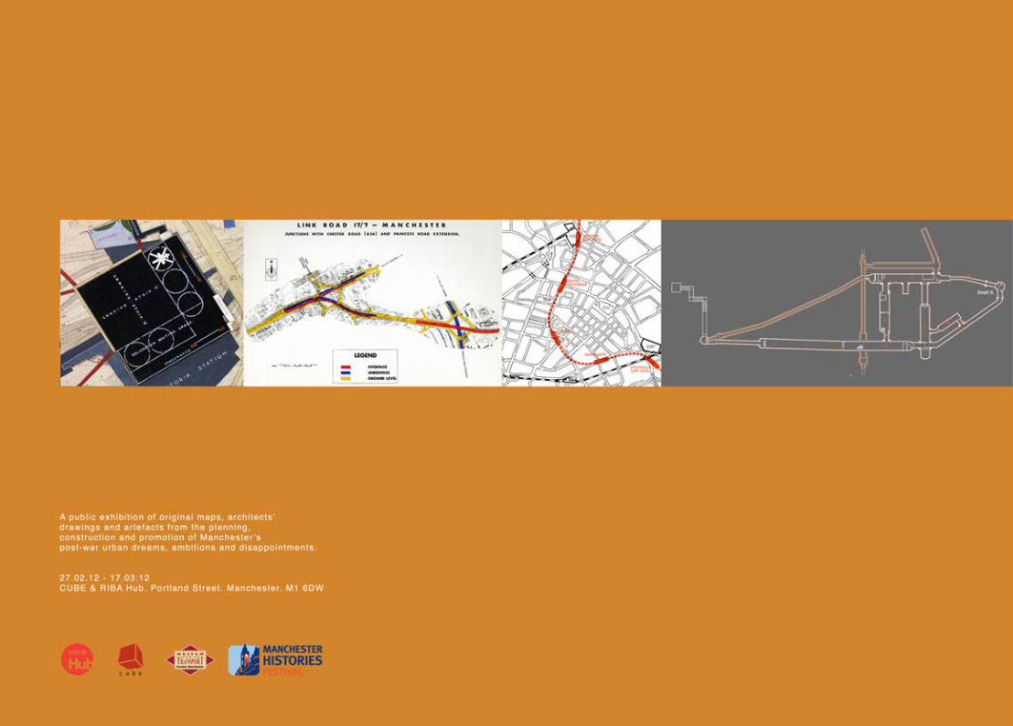
Catalogue to accompany the exhibitionCUBE Gallery | RIBA Hub Spring 2012

Infra_MANC

Infra_MANCPost-war infrastructures of Manchester
The catalogue of Infra_MANC. An exhibition at the RIBA Hub / CUBE Gallery, Portland Street
Manchester from 27th February – 17th March 2012.
Curated by Richard Brook and Martin Dodge
Richard Brook Manchester School of Architecture, John Dalton West, Chester Street, Manchester. M1 5GD, UK.
Martin Dodge Department of Geography, University of Manchester, Oxford Road, Manchester, M13 9PL, UK.

Infra_MANC Prelims
Second edition 2012© Richard Brook and Martin Dodge 2012
All rights reserved. No part of this publication may be reproduced, stored in a retrieval system or transmitted in any form or by any means, electronic, mechanical, photocopying, recording or otherwise without the prior permission of the publisher.
Richard Brook and Martin Dodge have asserted their right under the Copyright, Designs and Patents Act, 1988, to be identified as the authors and editors of this work.
Published by bauprint34 Milton RoadPrestwichManchesterM25 1PT
ISBN 978-0-9562913-2-5
Infra_MANCPrelims
Table of contents
Acknowledgements
Curator biographies
Introduction and overview map
Timeline
Ch.001 Helicopter Dreaming
Ch.002 Mancunian Way [A57(M)] Our Highway in the Sky
Ch.003 The Picc-Vic Tunnel
Ch.004 Guardian Underground Telephone Exchange
Bibliography
List of exhibits
Exhibition photos

Infra_MANC Prelims
ACKNOWLEDGEMENTS
Copyright
The exhibition and catalogue are an academic project and were undertaken on a non-commercial basis. We have assembled visual materials from a large number of sources and have endeavoured to secure suitable permissions. We have also tried to give proper credits to sources and original creators of images. Apologies to anyone who feels we have failed to obtain permission or to provide appropriate acknowledgements. Please contact us and we will seek to amicably resolve the situation.
Please note many of the images presented in this catalogue remain under copyright of their owners and original creators.

Infra_MANCPrelims
This exhibition and catalogue would not have been possible without the kind assistance of a great number of individuals. Firstly, we would like to thank James Thorp and Nicholas Mitchell for allowing us to use their work as the basis for the chapters on Mancunian Way and the Guardian Underground Telephone Exchange, their excellent research provided a sound base from which to continue and they also produced some of the quality diagrams in this volume.
We are greatly indebted to George Turnbull and his colleagues at the Museum of Transport Greater Manchester. We have a significant number of items on loan from their archive and George’s deep knowledge of the region and his own collection of transport related artefacts has been vital to our work. The fantastic Futuroute machine, held at the Museum, was brought back to working condition by Richard Rudd, for this we are tickled and grateful.
David Govier and his colleagues at Manchester Archives have been patient and eager to assist as we dug deeper into helicopter sub-committee minutes and engineering microcards. The most unique and exciting drawings on display, the heliport, are from this valuable resource that Manchester City Council and the Association of Greater Manchester Authorities support. [We wish them every success as they consolidate the local studies and archival resources over the coming years and in readiness to move back into the Central Library]. More generally, the staff at GMCRO, Manchester Archives and the local studies service have been very helpful for our various spells of research on the structure of Manchester over the last few years. Thanks, in particular, to Gwen Jolley [now retired from GMCRO], who patiently explained what was held on the microcard archive of city engineer’s plans.
Mark Westgarth and Jane & John Weightman have kindly loaned their paintings of Picc-Vic stations and Ellen at Capes Dunn Auctioneers helped us in tracking down some of these exhibits. We wish to thank Geoff Senior at the Northwest Film Archive for his immediacy in responding to enquiries and his fingertip precision in the provision of contacts as we sought to clear some of the footage on display. Thanks also to Edwin Trout of the Concrete Society for approving the use of the film of Mancunian Way. We also need to acknowledge George Coney for his openness in sharing his digital collection on the ‘secret’ Guardian space in response to a simple email out of the blue. Nick Catford and Richard Lamont provided prompt and positive responses to our ‘underground’ email queries.
Insightful conversations and helpful feedback from Clive Mainwaring, David Suggitt, George Coney, Tom Wray, Wayne Cocroft and Eric Larmett have added to the content of the chapters and provided information and anecdotes that only enrich the infrastructural stories we aim to tell. We would also like to say thanks to Malcom Graham for the use of his words in the description of what it was like to work in the Guardian Exchange.
At the Department of Geography, the University of Manchester, Tim Allott, Director of Research, has been supportive, John Moore provided some need heavy lifting and Graham Bowden of the Cartography Unit produced several versions of some of the maps seen across these pages. Steve Millington and the Manchester Modernist Society have kindly agreed to lead a walking tour of Mancunian Way to augment the exhibition. Tom Jefferies, Head of School at the Manchester School of Architecture encouraged a successful funding bid to MIRIAD at MMU, we would like to thank him and Professors John Hyatt and David Crow for their support.
Jane and Kate at CUBE have been fantastically helpful and quick to react to a rapidly shifting exhibition framework. Urun at the RIBA Hub has been attentive and organised in a way that we could never hope to be.
· On a personal note Richard would like to say thankyou to Nina for her unending patience and to Martin for pushing when there was no time left to push.
· Martin would like to acknowledge the funding support from the Manchester Geographical Society [via Paul Hindle] and the J.B. Harley Fellowship in the History of Cartography [administered by Rose Mitchell] that made possible a productive spell of research at the National Archives in summer 2011. Lastly, many thanks to Richard for the huge amount of creative energy and effort he has expended on the exhibition. Its been a lot of fun and really quite strange how an email sent on Friday 13th Feb. 2009 about an unassuming concrete wall can lead in new directions

Infra_MANC Prelims
BIOGS

Infra_MANCPrelims
Curator biographies Richard BrookManchester School of Architecture, Manchester, UKRichard is a Senior Lecturer in Architecture and a qualified Architect. He is head of the 3rd year undergraduate course at the Manchester School of Architecture and co-director of [Re_Map], an MArch level ‘research by design/design by research’ unit concerned with the mapping and representation of urban space and utilising advanced computation. He is the co-author of Urban Maps [Ashgate: 2011] He has had a long association with electronic arts, through rave culture, electronic music and post-graffiti generative environments. His assertion that architecture is made of more than built objects directs most of his enquiry into the contemporary city. His current research involves infrastructures and interstices.
Martin Dodge Department of Geography, University of Manchester, UKMartin’s research focuses on conceptualising the socio-spatial power of digital technologies and virtual geographies, and the theorisation of visual representations, cartographic knowledges and novel methods of geographic visualization. He curated the well-known web-based Atlas of Cyberspaces and has co-authored three books covering aspects of the spatiality of computer technology: Mapping Cyberspace [Routledge: 2000], Atlas of Cyberspace [Addison-Wesley: 2001] and Code/Space [MIT Press: 2011]. He’s also co-edited three books, Geographic Visualization [Wiley 2008], Rethinking Maps [Routledge: 2009] and The Map Reader [Wiley-Blackwell: 2011], all focused on the social and cultural meanings of new kinds of mapping practice. He really likes digging out maps of old infrastructure.

Infra_MANC Introduction
INTRODUCTION
Infra_MANCIntroduction
Infra_MANC: Post-war infrastructures of Manchester
One way to academically approach the city is to interrogate the infrastructures that keep it moving, operating and communicating. Engaging extensively the materiality and technicality of infrastructure is still relatively uncommon in the social sciences. It is also somewhat unusual to focus on infrastructure that never came to be and technical systems that remained on the paper plans.
Infrastructure typically exudes physical permanence, at least to superficial visual inspection, and on the overview plans and construction schematics, it can appear so believably real. Moreover, the functioning of technical space and built structures as infrastructure services for the city often equates to cultural permanence, which has generated a widespread lack of technological comprehension [or even awareness] by the general public. Essential to infrastructure is that it can be seen as invisible and ignored in everyday discourse. In established industrialised cities, like Manchester, the ‘basic’ utilities of water, power and communications are seemingly present everywhere and always ‘on’ and working, presenting an image of infrastructural permanence and stability. In contrast to this image of permanence and stability, systems of infrastructure are in reality delicately balanced and prone to failure, which can expose the vulnerability of urban processes that depend upon them. As such, one of the defining aspects of utilities and structures, which achieve cultural status of infrastructure, is that they become ‘visible upon breakdown’.1

Infra_MANC Introduction
Infrastructure Researching This limited project has sought to uncover the technical specification of, and socio-political context for, several infrastructural elements and plans in Manchester as a means to examine the post-war decades and the dreams, ambitions and realities concomittant with societal changes between the early 1950s and the mid 1970s.
The research conducted over the last half year has delved into the engineering detail and concrete materialities of a number of iconic projects and several unrealised infrastructural dreams within post-war Manchester and the impact these have had on the shape of the contemporary city. The immediate goal for the research was to build up a narrative understanding and a visual record of the four key modes of communication – road infrastructure, railway transportation, passenger aviation and telecommunication - and to display this to people in the city. The results are assembled as Infra_MANC an exhibition that seeks to analyse the conception, planning, construction and promotion of four key infrastructural projects: the Mancunian Way, the never realised Picc-Vic railway tunnel, the Guardian telephone exchange and fanciful dreams of a city centre heliport.
Two were built as planned at considerable financial cost, but were rather ineffectual by completion, two were to remain the unrealised dreams of city planners. They were large scale pieces of infrastructure, that it was imagined would create new spaces for communication, with two being buried underground and two being up in the air to facilitate movement above the congested city. They partially overlap and intersect across and through the central area of Manchester [see Overview Map]. One is an infrastructure icon [the Mancunian Way] , another is a source of intrigue for some [the Guardian underground exchange], and the two unrealised infrastructures are significant in that they offer scope to imagine how the city would be different had they been built.
We have chosen to approach the materiality and imagined forms of these four infrastructures by analysing them primarily through visual artefacts of engineers and original mapping of the planners, much of which is never normally published or even meant to be exposed to the public. Undertaking primary research in archives, seeking recollections of those involved and borrowing key items held in private collections, we have striven to present the distinctive aesthetic of a Modern city as viewed from the professional eyes of the engineer, technically-minded architects and the transport planner. Many of the drawings are highly technical – apparently de-humanised and seemingly a-political – showing only what was to be

Infra_MANCIntroduction
manufactured and installed. Whilst harsh at first sight, infrastructure often has sculptural qualities to its insertion in the landscape, the angular geometries, specified materials and architectural styling often speaks of the age in which they were conceived. Infrastructural plans, sectional diagrams and drawings depict fluidly shaped lines of piping routing, sinuous steel reinforcing and muscular concrete forms, along with arrays of cryptic acronyms and hand-drawn annotations that truly invites visual scrutiny. The rewards from the time one must take to decode the content of such engineering schematics and planners diagramming of space, we would argue, bring a new kind of mechanistic beauty to the fore. Of course, one might counter-argue that it is not beauty one is seeing displayed, but merely infrastructure being laid bare to be easily objectified as pornographic exposure of the working of city space. We leave it to the judgement of visitors to the exhibition and readers of this catalogue to reach a verdict.
In trying to find the right kind of plans, maps and schematics of infrastructure we spent many [happy] hours in libraries and online catalogues tracking down obscure technical reports, as well as wading through mundane committee minutes and correspondence between public officials. Most importantly, we have been able exploit several valuable, locally-held, archives that have been little or never used before, including, firstly, the collections held by the Transport Museum Greater Manchester relating to 1960s and 1970s activities of the city and regional transport authorities. While the museum is best know for its big buses, restored trams and other large metallic objects, it actually has accumulated a sizeable archive of textual materials, including important documents, printed ephemera, unpublished reports and working plans. This material has little or no cataloguing but has yielded some valuable artefacts for this exhibition. [We are most grateful to George Turnbull in facilitating access and guiding the research at the museum.] However, the most significant archival resource that has underpinned this exhibition project is the huge collection of plans of the Manchester City Engineers and Surveyors Department that were photographed onto microcards in the mid 1980s.2 Stored at GMCRO the filling cabinets contain many thousands of plans, maps and drawings. Many of the most interesting plans displayed in this catalogue came from this source, including key material regarding the Picc-Vic stations [Chapter Three] and the sites of potential heliports [Chapter One]. This collection also contains much else we are sure and merits greater scrutiny for those interested in the history of Manchester as narrated through built structures. Unfortunately, it is rather physically inaccessible and lacks readily usable indexes.
The Guardian Exchange, as befitting its ‘secret’ status remains a mysterious place in terms of published records [there is little detail publicly available in the BT Archives] and here we have tended to rely on informed amateurs, obscure technical publications from the period and comment from ex-GPO workers who had first hand experiences.
Also, some serendipity was involved in putting together the exhibition. This included spotting the auction of David Fricker’s original architectural renders for the never-built Picc-Vic underground station and realising their significance to understanding how this infrastructure proposition [a big, expensive tunnel] needed to be imagined as space for paying passengers. Whilst a passing conversation with Gwen Jolley at GMCRO lead to the discovery of the over-sized, original contract drawings for the Mancunian Way, that were lying unappreciated and uncatalogued in the attic store.

Infra_MANC Introduction
Infrastructural temporality We have also consciously taken on a historically-focused descriptive epistemology, seeking to understand how the infrastructures were imagined in different times and socio-economic circumstances; the optimism of the immediate aftermath of war, the reality of construction in the 1960s and the disappointments with the economic downturn of the 1970s, all against a backdrop of increasing paranoia of the cold war. The 25 year period at the heart of Infra_MANC encompasses the fortunes of Britain in the post-war era and lurches wildly from far reaching vision and technoscientific ambition to disappointments at funding cuts and failed dreams.
As such the infrastructural schemes and proposals seen here can be said to mirror and provide a regional narrative to the rapidly shifting politics of the post-war era, from a can do optimism, to political fear, to pragmatic delivery in the face of boom and demand onward to economic instability. The need for heliport infrastructure were ambitious projects buoyed by technological advances made during Second World War and bolstered by the desire for social and economic recovery. Whether viewing the Parliamentary and municipal discourse or indeed the drawings themselves, the sense of optimism and the capacity to succeed is palpable. The Guardian underground exchange was built amidst a climate of deepening anxiety about the Soviet threat in the 1950s and paternalism of the British state that tried to keep the public in the dark about the realities civil defense.
The Mancunian Way was a rapid-fire solution to the growing traffic demands on the city. It was a necessity to allow the city to continue to function as it rode the boom of the 1960s. It’s stark exposed structure was promoted by the city architect S.G. Besant-Roberts, whose other buildings demonstrate a no-nonsense approach to building in the face of demand. The Picc-Vic tunnel was a complex proposal with multi-agency participants and more political weight than it was able to sustain through the oil crisis and economic depression of the 1970s. The layers of unresponsive and unaccountable bureaucrats and processes and the brinkmanship of local and national politics can be seen to characterise the disputes and failures of the decade.
The time periods that are subject to focus here are interesting. They are becoming old enough to be history but recent enough to be real for many and relevant for everyone living and working in Manchester.
BELOW. The materiality of the infrastructural archive – the microcard collection of plans and maps of Manchester City Engineers and Surveyors Department [Source: Author’s photograph]

Infra_MANCIntroduction
Infrastructural allure The world below may be our [scarcely inexhaustible] mine of wealth, and the place to which we scurry in the hope of shelter , but it is also where we bury whatever we most want to keep out of sight : radiation, unutterable destruction, and our dress rehearsals for universal death.3
The allure of the underground, and possible secrets held within subterranean spaces, is an intrinsic aspect of the infrastructural imaginary. Of course with pragmatic logic much infrastructure is purposeful built beneath the habitable city above. The sinking of infrastructure cognitively and visibly into the ground is significant in hampering the public understanding of how it works and heightening its appeal as a site of sublime horrors. There are many ways the underground resonates in human psyches and cultural discourse4, and we are admittedly ourselves drawn by such subterranean aspects of the city. The allure of infrastructure is very clearly reflected in the subjects chosen for this exhibition. One infrastructure is well known and obvious [Mancunian Way] but actually there is little in the way of a comprehensive summarisation or interpretative analysis of how it came be ‘inserted’ into Manchester in the 1960s. The Picc-Vic scheme and the Guardian underground exchange are fairly well known and visible in discursive materials but they both lack substantive recording of their infrastructural form. Few people know about plans in the 1950s for heliports in the city. This then is the primary reason why we’ve ended up writing substantive chapters in the catalogue. [We have been exceptionally well assisted in this regard by being able to exploit, with their permissions, the earlier dissertation research of Nicholas Mitchell5 and James Thorp6]. One goal of Infra_MANC has been to to provide a published resource that will be of value to other researchers and as such we have tried to be synoptic and scrupulous about sources.

Infra_MANC Introduction
Retrofuture The contemporary infrastructural situation: Metrolink trams rather than an underground railway, a defunct telecoms cavern, a motorway deemed ‘pathetic’ and a ten year hopeless dream of intercity hovering may make it seem as if the city could never achieve its dreams. The reality is that nationally imposed plans can be achieved in a top down construct. The local ambitions, not cloaked in secrecy, were subject to complex local authority relationships and awkward political oppositions with those holding the purse strings in London.
We hope, however, that visitors to the exhibition will come to see something of the infrastructure of Manchester via our curation of original maps, engineers schematics, architects drawings and marketing ‘machines’ that we have brought together in an attempt to expose the role of communications infrastructure in the contemporary city and to introduce historical context to these overridingly technological propositions.
Richard Brook, Martin Dodge
Manchester, February 2012
1 Star, S. and Bowker, G. [2006] ‘How to infrastructure’, Lievrouw, L.A. and Livingstone, S. [eds] Handbook of New Media: Social shaping and social consequences of ICTs [London: SAGE], p.231.
2 The creation of this collection is partly explained in this article: John, S. and Guest, P. [1986] ‘Mapping Manchester’s sewers: The engineering archives project’, Manchester Region Local History Review, 2[2]: 33-37, <http://www.mcrh.mmu.ac.uk/pubs/pdf/mrhr_02ii_john_ guest.pdf>.
3 Parrinder , P. [1990] ‘Troglodytes’, London Review of Books, 25 October, p.24.
4 Williams, R. [2008] Notes on the Underground [Cambridge, MA: MIT Press].
5 ‘Permanent Structure Redundant Programme: An enquiry into how the perception of the ‘Guardian Underground Telephone Exchange’, An unpublished dissertation submitted to the Manchester School of Architecture for the degree of Bachelor of Architecture, by Nicholas J. Mitchell 2010.
6 ‘Highway in the Sky: A socio-technical analysis of the urban motorway.’ An unpublished dissertation submitted to the Manchester School of Architecture for the degree of Bachelor of Architecture. James K. Thorp 2010.
LEFT. Cover of pamphlet to accompany exhibition of the 1945 City of Manchester Plan at Manchester City Art Gallery, July-September 1945. [Source: Private collection]

Infra_MANCIntroduction
RIGHT. Overview Map. The four infrastructures being interpreted in the Infra_MANC exhibition are displayed on a 1950s era street map of Manchester city centre. [Source: Map compilation created by Graham Bowden, Cartography Unit, University of Manchester]

Infra_MANC

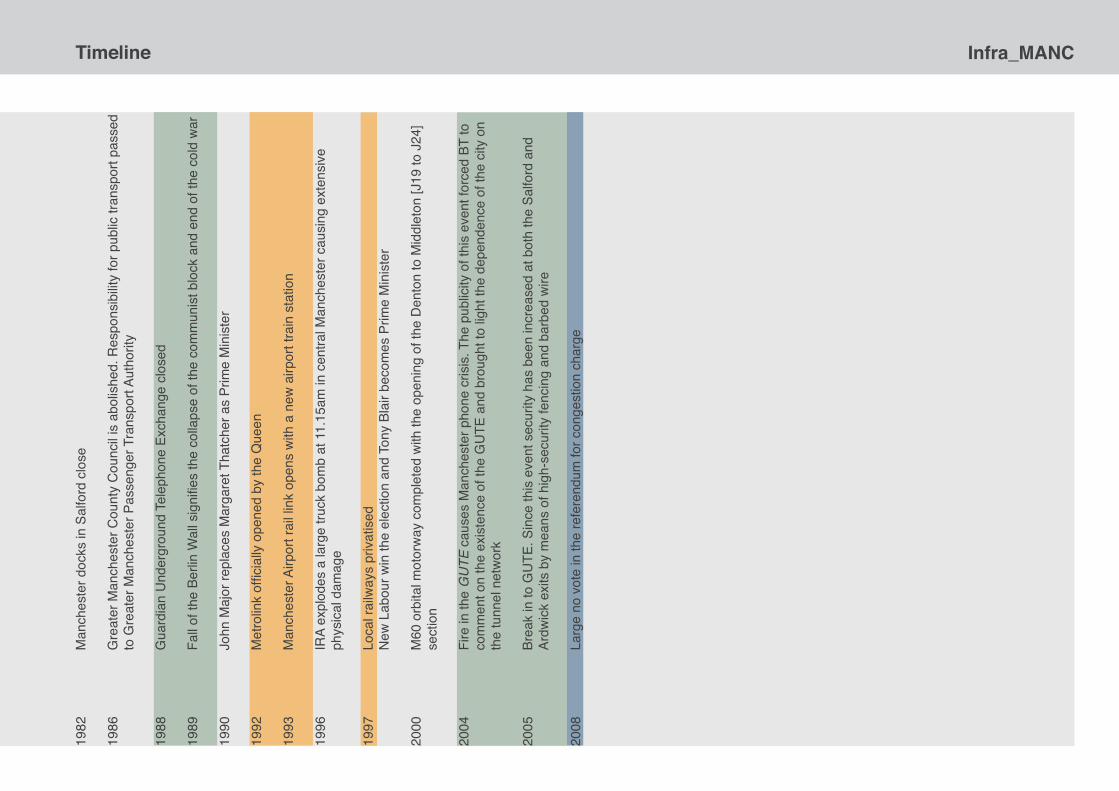
Infra_MANCTimeline
TIMELINE

Infra_MANC Timeline18
30
Wor
ld’s
first
true
railw
ays
star
ted
oper
atin
g fro
m a
pur
pose
bui
lt st
atio
n on
Liv
erpo
ol
Roa
d
1868
D
idsb
ury
to A
lber
t Squ
are
light
railw
ay ro
ute
prop
osed
with
und
ergr
ound
sec
tion
in c
ity
cent
re
1884
Q
ueen
Vic
toria
offi
cial
ly o
pene
d th
e M
anch
este
r Shi
p C
anal
1901
M
anch
este
r Cor
pora
tion
com
men
ced
elec
tric
tram
way
ope
ratio
n [A
lber
t Squ
are
to
Che
etha
m H
ill]
19
03
Und
ergr
ound
railw
ay p
ropo
sed
with
new
sta
tion
unde
r the
site
of t
he fo
rmer
infir
mar
y at
Pi
ccad
illy
1914
U
nder
grou
nd tr
am ro
ute
prop
osed
alig
ned
with
Lon
don
Roa
d an
d M
arke
t Stre
et to
con
nect
Ex
chan
ge a
nd L
ondo
n R
oad
railw
ay s
tatio
ns 19
22
Pl
anni
ng E
xhib
ition
in M
anch
este
r
1926
R
epor
t of t
he M
anch
este
r and
Dis
trict
Joi
nt T
own
Plan
ning
Com
mitt
ee, i
nclu
ding
co
ntrib
utio
ns fr
om P
atric
k Ab
ercr
ombi
e
1931
Und
ergr
ound
sch
eme
to li
nk V
icto
ria a
nd O
xfor
d R
oad
stat
ions
inve
tsig
ated
1932
Inst
ruct
ions
by
City
Cou
ncil
to p
repa
re d
esig
ns fo
r city
cen
tre ri
ng ro
ad
1934
Firs
t Civ
ic C
entre
des
igns
by
G. N
oel-H
ill [C
ity A
rchi
tect
]
1935
Publ
icat
ion
of R
ebui
ldin
g M
anch
este
r, Er
nest
D. S
imon
1936
Firs
t flig
ht o
f a tr
uely
con
trolla
ble
helic
opte
r, th
e Fo
cke-
Achg
elis
FW
61 in
G
erm
any
Publ
icat
ion
of M
anch
este
r Mad
e O
ver,
Alfre
d P.
Sim
onAp
poin
tmen
t of R
owla
nd N
icho
las
[City
Sur
veyo
r]
New
tube
railw
ay ro
ute
prop
osed
for M
anch
este
r as
a lo
op to
con
nect
all
the
stat
ions
at t
he
edge
of t
he c
ity
1938
M
anch
este
r Rin
gway
Airp
ort o
pene
d
1939
St
art o
f the
Sec
ond
Wor
ld W
ar
1940
Bom
bing
dur
ing
the
Chr
istm
as B
litz
caus
es w
ides
prea
d de
stru
ctio
n in
M
anch
este
r and
Sal
ford
1942
Plan
ning
wor
k co
mm
ence
s on
194
5 C
ity o
f Man
ches
ter P
lan
1945
Vict
ory
in E
urop
e, p
artia
l end
of t
he S
econ
d W
orld
Tr
inity
test
of t
he fi
rst a
tom
ic b
omb
City
of M
anch
este
r Pla
n 19
45 p
ublis
hed
Exhi
bitio
n of
194
5 Pl
an a
t City
Art
Gal
lery
Prop
osal
s fo
r Lin
k R
oad
17/7
app
ear a
s ea
rly a
s 19
45, a
s pa
rt of
the
prop
osed
re-p
lann
ing
of M
anch
este
r’s c
entra
l are
a in
the
City
of M
anch
este
r Pla
n.
1946
Th
e 19
46 ‘T
ea R
oom
Pla
n’ [s
o ca
lled
as it
was
exh
ibite
d to
MPs
in th
e H
ouse
of C
omm
ons
refe
ctor
y], i
dent
ified
trun
k ro
utes
tota
lling
800
mile
s.
1947
Tow
n an
d C
ount
ry P
lann
ing
Act
Briti
sh E
urop
ean
Airw
ays
form
s ex
perim
enta
l hel
icop
ter u
nit i
n pr
epar
atio
n fo
r
fu
ture
pas
seng
er s
ervi
ces
1948
Ope
ratio
n of
Man
ches
ter’s
last
tram

Infra_MANCTimeline19
48
Fi
rst p
rogr
amm
able
, sto
red
mem
ory,
com
pute
r - n
ickn
amed
‘bab
y’ - w
as d
evel
oped
at
M
anch
este
r Uni
vers
ityR
ailw
ay n
atio
nalis
atio
n
1949
Sovi
et U
nion
test
s its
firs
t ato
mic
bom
bLo
cal G
over
nmen
t Bou
ndar
y C
omm
issi
on re
com
men
ds tw
o-tie
r cou
ntie
s
1951
M
anch
este
r Cor
pora
tion
subm
its th
eir D
evel
opm
ent P
lan
unde
r the
term
s of
the
1947
Tow
n &
Cou
ntry
Pla
nnin
g Ac
t
1951
Ki
ng G
eorg
e op
ens
Fest
ival
of B
ritai
n on
Lon
don’
s So
uth
Bank
whi
ch s
ets
the
tom
e fo
r the
op
timis
m a
nd d
ream
s of
the
1950
sW
inst
on C
hurc
hill
beco
me
Prim
e M
inis
ter a
gain
, afte
r Con
serv
ativ
e Pa
rty n
arro
wly
win
s th
e G
ener
al E
lect
ion
Spyr
a’s
sche
me
for a
roof
top
helip
ad o
n a
new
bui
ldin
g in
Man
ches
ter c
ity c
entre
is
circ
ulat
ed
Salfo
rd s
ite fo
r GU
TE re
quis
ition
ed
1952
Firs
t tes
t of B
ritis
h at
omic
bom
b
1953
Bu
ildin
g st
arts
on
the
GU
TE
Cor
onat
ion
of Q
ueen
Eliz
abet
h II
1955
M
anch
este
r Gua
rdia
n re
ports
Tra
vis
Stre
et s
ite s
elec
ted
for t
he h
elip
ort f
or th
e ci
ty
1954
Te
st o
f the
firs
t hyd
roge
n bo
mb
oblit
erat
es p
art o
f Bik
ini a
tol i
n th
e Pa
cific
1956
R
oofto
p he
lipor
t pla
n fo
r Vic
toria
Sta
tion
was
cre
ated
1957
H
arol
d W
atki
nson
, Min
iste
r of T
rans
port
from
195
5-59
, ann
ounc
ed th
e ne
xt m
ajor
pla
n fo
r th
e m
otor
way
net
wor
k in
195
7
H
arol
d M
acm
illan
beco
mes
Prim
e M
inis
ter
Furn
ishi
ng o
f the
GU
TE c
ompl
ete
1958
Th
e fir
st e
ight
mile
s of
hig
h-sp
eed
road
wer
e op
ened
by
then
Prim
e M
inis
ter H
arol
d M
acm
illan.
Eve
n th
is re
lativ
ely
shor
t stre
tch
of w
hat w
as to
late
r bec
ome
part
of th
e N
orth
-Sou
th M
otor
way
, the
n th
e M
6, to
ok 2
1 ye
ars
from
the
loca
l aut
horit
y’s in
itial
re
com
men
datio
n to
com
plet
ion
1958
.
Po
st O
ffice
wor
ks b
ill. S
ubm
itted
to p
arlia
men
t was
this
bill,
whi
ch w
ould
pro
vide
th
e Po
stm
aste
r Gen
eral
with
the
pow
er to
mai
ntai
n co
mm
unic
atio
n sy
stem
s in
dee
p ex
cava
tions
in L
ondo
n, M
anch
este
r and
Birm
ingh
am. e
xpira
tion
of th
e 19
45 R
equi
sitio
ned
Land
and
War
Wor
ks A
ct.
GU
TE o
pens
, 7th D
ecem
ber A
t 8.0
0am
the
non-
dire
ctor
Exc
hang
e op
ened
for t
raffi
c
1959
A
parli
amen
tary
deb
ate
led
to th
e cr
eatio
n of
a m
ultid
isci
plin
ary
stud
y gr
oup
with
in th
e D
epar
tmen
t of T
rans
port,
to u
nder
take
the
Stud
y of
the
Long
Ter
m P
robl
ems
of T
raffi
c in
To
wns
.
1960
Lo
ndon
Roa
d st
atio
n w
as re
nam
ed M
anch
este
r Pic
cadi
lly w
hen
it re
open
ed a
fter
1961
Appr
oval
of M
anch
este
r’s D
evel
opm
ent P
lan
with
con
ditio
ns to
revi
sit c
entra
l com
pone
nts
Ham
mer
smith
flyo
ver i
n Lo
ndon
ope
ns 19
62
SE
LNEC
, A H
ighw
ay P
lan
Appo
intm
ent o
f Sid
ney
G. B
esan
t-Rob
erts
[City
Arc
hite
ct]
Leon
ard
Cec
il H
owitt
[City
Arc
hite
ct] r
etire
s
reco
nstru
ctio
n
19
63
M
anch
este
r’s fi
rst C
hief
Pla
nner
app
oint
ed, J
ohn
Stan
ley
Milla
r
Lo
ng s
ervi
ng C
ity S
urve
yor R
owla
nd N
icho
las
retir
esTr
affic
in T
owns
repo
rt is
pub
lishe
d Es
tabl
ishm
ent o
f the
SEL
NEC
Are
a La
nd-u
se T
rans
porta
tion
Stud
y [S
ALTS
]

Infra_MANC Timeline19
64
D
esig
natio
n of
Man
ches
ter’s
Com
preh
ensi
ve D
evel
opm
ent A
reas
Har
old
Wils
on b
ecom
es P
rime
Min
iste
r
1965
Th
e Lo
cal G
over
nmen
t Com
mis
sion
for E
ngla
nd p
rese
nted
dra
ft re
com
men
datio
ns fo
r a
new
cou
nty
in D
ecem
ber 1
965
Beec
hing
pla
n le
ad to
‘axi
ng’ o
f lar
ge p
arts
of t
he B
ritis
h ra
ilway
net
wor
k
1966
Br
itish
Rai
l spo
nsor
ed tu
nnel
pla
ns a
re d
evel
oped
alo
ngsi
de M
anch
este
r Cor
pora
tion’
s in
vest
igat
ion
of m
onor
ail.
1967
Vo
mue
1 o
f Man
ches
ter R
apid
Tra
nsit
Stud
y pu
blis
hed
and
prop
oses
ele
ctric
tram
link
be
twee
n R
ingw
ay a
nd M
iddl
eton
with
und
ergr
ound
city
sec
tion
Man
ches
ter’s
Dra
ft C
ity C
entre
Pla
n pr
oduc
ed a
nd a
ppro
ved
it in
clud
ed s
ever
al C
DA
de
sign
atio
ns w
hich
wou
ld c
ome
to s
hape
the
city
[on
the
surfa
ce]
The
Civ
ic A
men
ities
Act
firs
t int
rodu
ced
cons
erva
tion
area
s in
to B
ritis
h le
gisl
atio
n
Rut
herfo
rd E
xcha
nge
com
plet
ed. T
he G
UTE
sys
tem
was
con
tinua
lly u
pgra
ded
and
in 1
967
a ne
w s
tand
ard
trunk
dia
lling
syst
em w
as in
trodu
ced
at th
e R
uthe
rford
exc
hang
e M
ancu
nian
Way
offi
cial
ly o
pene
d by
PM
Har
old
Wils
on
1968
Tran
spor
t Act
Amen
dmen
ts to
Tow
n an
d C
ount
ry P
lann
ing
Act
GU
TE m
ade
publ
ic. O
n th
is d
ate,
the
unde
rgro
und
Exch
ange
was
dec
lass
ified
by
the
with
draw
al o
f Def
ence
not
ices
Vo
umes
2 a
nd 3
of M
anch
este
r Rap
id T
rans
it St
udy
publ
ishe
d
1969
SELN
EC P
asse
nger
Tra
nspo
rt Ex
ecut
ive
form
edTh
e R
epor
t of t
he R
oyal
Com
mis
sion
on
Loca
l Gov
ernm
ent i
n En
glan
d, p
opul
arly
kno
wn
as
the
Red
cliff
e-M
aud
Rep
ort,
reco
mm
ends
uni
tary
aut
horit
ies
1970
St. A
nne’
s Sq
uare
firs
t Man
ches
ter c
onse
rvat
ion
area
SELN
EC in
trodu
ces
its d
istin
ctiv
e or
ange
and
whi
te b
us li
very
1971
SELN
EC [M
anch
este
r Cen
tral A
rea
Rai
lway
, etc
] bill
depo
site
d w
ith P
arlia
men
t
In
frast
ruct
ure
gran
t app
licat
ion
for P
icc-
Vic
mad
e
1972
Loca
l Gov
ernm
ent A
ctPa
rliam
enta
ry p
ower
s gr
ante
d fo
r Pic
c-Vi
c
Es
sex
Goo
dman
Sug
gitt
appo
inte
d as
arc
hite
cts
for P
icc-
Vic
1973
Cre
atio
n of
Gre
ater
Man
ches
ter C
ount
y C
ounc
ilO
il cr
isis
UK
join
s th
e C
omm
on M
arke
tIn
frast
ruct
ure
gran
t for
Pic
c-Vi
c tu
rned
dow
n
1974
Gre
ater
Man
ches
ter l
egal
ly re
cogn
ised
Apr
il 1s
t 197
4
S.
G. B
esan
t-Rob
erts
[City
Arc
hite
ct] r
etire
sC
entre
line
shut
tle b
us b
etw
een
Vict
oria
and
Pic
cadi
lly is
intro
duce
d
Lo
cal G
over
nmen
t Fin
ance
Act
1975
Tran
spor
t Min
iste
r Fre
d M
ulle
y vi
sits
Man
ches
ter t
o ex
amin
e re
gion
al p
ropo
sals
1976
UK
requ
ired
a £2
.3bn
bai
lout
from
the
IMF
Mai
n pa
rt of
the
Arnd
ale
shop
ping
ope
ns in
cen
tral M
anch
este
r
1979
Mar
gare
t Tha
tche
r is
elec
ted
as P
rime
Min
iste
r
1980
Man
ches
ter b
ecam
e th
e fir
st B
ritis
h N
ucle
ar F
ree
City
1981
Br
itish
Tel
ecom
mun
icat
ions
Act
pas
sed.
Pas
sing
of t
his
act m
eant
Pos
t Offi
ce
Tele
com
mun
icat
ions
bec
ame
know
n as
Brit
ish
Tele
com
and
was
now
a s
tate
-ow
ned
corp
orat
ion
inde
pend
ent o
f the
Pos
t Offi
ce.
Infra_MANCTimeline19
82
M
anch
este
r doc
ks in
Sal
ford
clo
se
1986
G
reat
er M
anch
este
r Cou
nty
Cou
ncil
is a
bolis
hed.
Res
pons
ibilit
y fo
r pub
lic tr
ansp
ort p
asse
d to
Gre
ater
Man
ches
ter P
asse
nger
Tra
nspo
rt Au
thor
ity
1988
Gua
rdia
n U
nder
grou
nd T
elep
hone
Exc
hang
e cl
osed
1989
Fa
ll of
the
Berli
n W
all s
igni
fies
the
colla
pse
of th
e co
mm
unis
t blo
ck a
nd e
nd o
f the
col
d w
ar
1990
John
Maj
or re
plac
es M
arga
ret T
hatc
her a
s Pr
ime
Min
iste
r
1992
M
etro
link
offic
ially
ope
ned
by th
e Q
ueen
1993
M
anch
este
r Airp
ort r
ail l
ink
open
s w
ith a
new
airp
ort t
rain
sta
tion
1996
IR
A ex
plod
es a
larg
e tru
ck b
omb
at 1
1.15
am in
cen
tral M
anch
este
r cau
sing
ext
ensi
ve
phys
ical
dam
age
1997
Lo
cal r
ailw
ays
priv
atis
edN
ew L
abou
r win
the
elec
tion
and
Tony
Bla
ir be
com
es P
rime
Min
iste
r
2000
M
60 o
rbita
l mot
orw
ay c
ompl
eted
with
the
open
ing
of th
e D
ento
n to
Mid
dlet
on [J
19 to
J24
] se
ctio
n
2004
Fi
re in
the
GU
TE c
ause
s M
anch
este
r pho
ne c
risis
. The
pub
licity
of t
his
even
t for
ced
BT to
co
mm
ent o
n th
e ex
iste
nce
of th
e G
UTE
and
bro
ught
to li
ght t
he d
epen
denc
e of
the
city
on
the
tunn
el n
etw
ork
2005
Br
eak
in to
GU
TE. S
ince
this
eve
nt s
ecur
ity h
as b
een
incr
ease
d at
bot
h th
e Sa
lford
and
Ar
dwic
k ex
its b
y m
eans
of h
igh-
secu
rity
fenc
ing
and
barb
ed w
ire
2008
Larg
e no
vot
e in
the
refe
rend
um fo
r con
gest
ion
char
ge

Infra_MANC Ch.001 | Helicopter Dreaming
HELICOPTERDREAMING
Ch.001 | Helicopter Dreaming Infra_MANC
Two alluring and visionary drawings that were apparently recovered from the attic of the Town Hall extension in 2005, and are on loan to this exhibition from the Manchester Archives, have led an investigation into the aspirations of the city in pursuit of ultimate mobility for the masses. This chapter considers a time in the middle of the twentieth century when the helicopter was new and thoroughly exciting form of flying that held great promise to revolutionise urban transportation. The focus is on the development of plans to accommodate passenger helicopters effectively into British cities and, in the context of Manchester, how the councillors and corporation officers worked to plan new heliport facilities in the city centre during the 1950s.
The‘concept for a high-speed personal helicopter was an early expression of what would become in the years immediately after World War II an extremely popular vision of the future. To many observers, the helicopter seemed to promise wings for the city dwellers who might land atop their apartments or office buildings. Unfortunately, helicopters were – and remain – difficult to fly, relatively unsafe, noisy, and energy inefficient.1
‘Helicopter’:Greekderivation,helixmeaning‘spiral’,pteronmeaning‘wing’
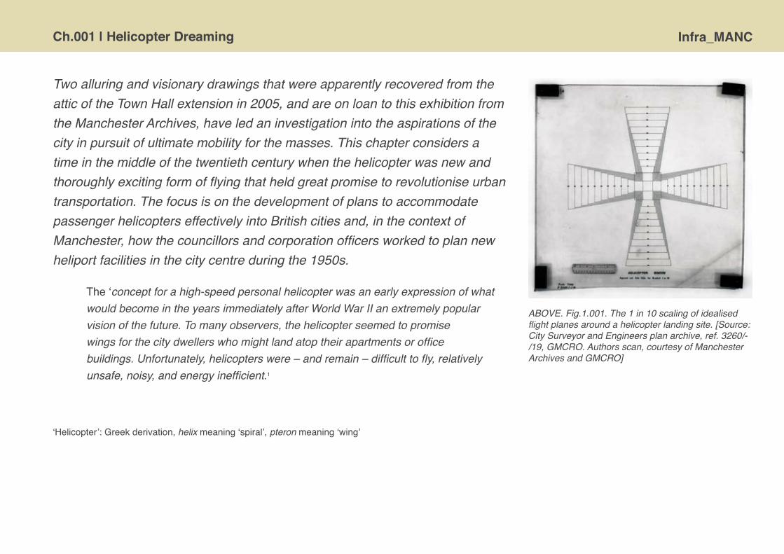
ABOVE. Fig.1.001. The 1 in 10 scaling of idealised flight planes around a helicopter landing site. [Source: City Surveyor and Engineers plan archive, ref. 3260/-/19, GMCRO. Authors scan, courtesy of Manchester Archives and GMCRO]
Infra_MANC Ch.001 | Helicopter Dreaming
Helicopter travel concept and urbanism Thenotionofflightviaarapidlyrotatingwingisold,perhapsinthemindsofancientGreekphilosophersanddatingbackatleasttoLeonardodaVinciinthefifteenthcenturywithhisnowwidelyknownandintriguingsketchofaprototypicalhelicopter.Practicaldevelopmenthadtowait,however,untilthelate1930swhensufficientlylightandpowerfulpistonengineswereavailableandallowedaircraftdesignerstogobeyondautogyroplanestotruehelicopters,capableofverticalliftandforwardflight,usingtherotorbladesalone.Despitemorethanhalfacenturyofsubsequenttechnicaladaptationandculturalassimilationthehelicopterremainsadistinctiveflyingvehicle,stillcapableofelicitingresponsewhenseenintheskies.Thesight-andsound-ofa‘copterhoveringlowoverheadstillstopspeopleintheirtracks.
Thehelicopterhassomeuniquecharacteristicsasamodeoftransportationthathavelongpromised-butnotyetdelivered-radicalchangestourbanstructure.Thekeyadvantageoversurfacetransportsisthespeedandabilitytotraverseoverspace.AsAlmysuccinctlynotedin1996,‘[t]heshortestdistancebetweentwopoints…isastraightlinewhichusuallycanbetravelledonlybyflyingviahelicopter.’2Ashasbecomeevidentinthepolicechasesscreenedontelevision,thehelicoptercaneasilyoutpaceeventhefastest,mostdetermineddriverwhoistiedtoroadspaces.Thepromisetobeabletoriseabovecongestedcitystreetsisappealing,withperceivedadditionaladvantagesforsomeofsecurityandanonymityoftravel.Thehelicopter’sadvantageoverfix-wingedaircraftisitabilitytolandverticallyandtherebyofferpoint-to-pointjourneys.Hereweseethehelicoptersfundamentalaffordances:forrapid,directpersonaltravelthatbreaksapartthecollectivejourneytiedtotrainsonrailsorairlinersandlongrunways.

Ch.001 | Helicopter Dreaming Infra_MANC
Tomakethemostofthebeneficialcharacteristicsofhelicopterflight,theaircraftrequiresitsowndedicatedspacesinthecitytolandsafely,unload,parkandrefuel.Theseareknownasheliportsorhelidromesandaredistinctfromsimplehelipadsforlanding.
The helidrome is a cleared space, an absence of obstacles or structures that could hinder the aircraft. It is designed so that the helicopter is free to fly safely. It ranges from a green pasture to a flat roof, and it seems characterised by the absence of architecture rather than its presence.3
Insomesenseshelipadsarethemostnotablephysicalfeatureofvirtualflightintheurbanlandscape.Thereare,however,planningandarchitecturaldesignchallengesforinsertinglargerheliportseffectivelyintocomplexandmulti-functionalurbanfabric.4Whileairportsarelocatedontheedgeofcities,adistancefrommostpopulationandinspaceopentotheskies,heliportsneedtobecentrallylocatedtoexploitthepoint-to-pointrapidityofverticalflight.Thislogicoflocationmakesthescaleoflandrequiredhardtojustifyincommercialtermsonlandingfeesalone,itisalsoboundupinthedifficultyofensuringthepadhasanunobstructedapproach.Thepresenceofaheliportinapopulatedareahasbeenknowntobeassociatedwithissuesofnoisedisturbanceandperceptionsofoperationalsafety[forwhatremain‘specialised’machinesintheeyesofthepublic].
Thenatureoftheheliportislittleconsidered,especiallyinrelationtolionisedstatusoftheairportwhichhasbecomeemblematicformajorcitiesconnectedintoglobalnetworkofflowsandindeedcomparedtocitiesthemselves.5

Infra_MANC Ch.001 | Helicopter Dreaming
Theheliportisoftenanafterthoughtandthehelicopterremainsanmechanicaloddity,lackingthesleekaestheticsoftheairlinersortheluxuryconnotationsofprivatejets.Ithasonlyaverymarginalroleinmostofourlives.Despitethehopesofenthusiastsandentrepreneurs,thehelicopterremainsstubbornlyasociallyexclusivemodeoftransport,mostevidentinspecialisttasks[particularlypolicingandemergencyrescue]andinnicheenvironments[suchastransportingworkerstooilrigsandotherinaccessiblesites].Mostpeoplesfirsthandexperienceofahelicopterflightisasanoccasionalrecreationalouting.
Whilethepracticalrealityofthehelicoptertodayisundoubtedlylimited,thecapacitytoflyremainsdeeplyappealingtogrounddwellinghumans.Elementaltothefascinationofthehelicopteristhatisseemstopromisedirectpoint-to-pointpersonal flight.SuchaerialtravelwasenvisagedbyAldusHuxleyinhisprophetic1930snovelBrave New World,wherepersonalhelicoptersareownedbytheelitetomove
ABOVE. Fig.1.002. Alex S. Tremulis’ concept sketch of a ‘Personal Helicopter’, 1943 [Source: scanned from Corn J.J. & Horrigan B. 1984. Yesterday’s Tomorrow’s: Past Visions of the American Future [The Johns Hopkins University Press, Baltimore, MD] p.100]

Ch.001 | Helicopter Dreaming Infra_MANC
abovethesocialmasses.MorebroadlyintheheadydaysoftheAmericanconsumerboomandthe‘infinitefuture’ofsuburbanisationinthe1950ssomeprophesisedthathelicopters,liketheautomobile,wouldcometofindaplaceineverygarage.Indeed,thetwomaywellfusetogetherintoapersonalheli-carsenablingthesuccessfullybusinessmantoflyfromhishomeinthecountrytothecityoffice[Fig.1.002].
Therearesocialconsequencestotheuseofhelicopterstoovercomespace.Whilewedonotnowhavewidespread,personalhelicoptersuse-andcertainlynotthesci-fidreamofheli-car-theaccessibilityofprivatemodesofflighthaseffectsonthemobilityoffewandtherightsofthemany.Thehelicopterisfundamentallyundemocratic.Ithasbeen,andremains,undoubtedlyatransporttoolfortheprivilegedanditsenableselitestobesocialexclusivebybypassingthespacesofinequalitythattheiractionshelpcreateandtoperpetuate.ThisiswellillustratedinSaulCwerner’sanalysisofextensiveuseofpersonalhelicoptersinSaoPaulo,Brazil.Ashenotes:‘Itistruethathelicoptertravelperpetuatesand,insomerespect,symbolises,thesocialdifferencesthatareinscribedinarchitectureandurbanism.’6 The dialecticalnatureofprivateexploitationofthecommonresourceoftheairspaceabovethecityiswellillustratedbytheissueofnoisedisturbance.Aswasnotedmanydecadesago:“[i]flargenumbersofexecutivestooktoflyingbyhelicopterinLondon,lifewouldbecomeunpleasantformanypeopleworkingthere”7.Toadvantagethefewabletoaffordtoflyabove,onemustdisadvantagethemanyleftbelow.Assuchweshouldresisttheinherentlyutopianrhetoricofthe‘freedomoftheskies’promulgatedbytheaviationindustrybyhighlightingthecapacityofthehelicoptertoengenderinequalityacrossurbanspace.
Infra_MANC Ch.001 | Helicopter Dreaming
The post-war promise of routine helicopter travel
Afterthesecondworldwarthehelicopterquiterapidlyemergedfrombeinganexperimentalmachinethatwasfundamentallyunstableandoftendownrightdangeroustoevenattempttofly,toamorestableand,critically,reliableaircraft.Ashelicoptersbecamereliableandcapable,peoplesawtheycouldbegintoplanservicesandschedulesthattheycouldbestundertake.Andasthehelicoptermatured,withmultiplecompetingmodels,itemergedinthe1950sasoneofkeyiconsofpost-warfuturism,promisingtheimminentrealityofmassinter-cityflightandallofitsutopianpossibilities.
Duringthisperiodtherewerevariousplansandproposalsadvancedforcentrallylocatedheliportsrequiredtobringthenewflyingcraftsafelyintotheheartofcity,andtheappealofrooftopschemesisreadilyapparent.AsoneMPnotedinaParliamentarydebateonheliportsin1953:
I believe that we are on the threshold of a helicopter age in Britain for internal passenger transport. … The point that I wish to emphasise is that only by the erection of elevated stations in the centre of our principal cities can we gain the maximum benefit from all the time-saving potentialities of these brilliant little machines.8
Forexample,intheUKmuchinterestfocusedonLondon,asthegreatestmarketforhelicopterusers,withproposalsadvancedintheearly1950sforahuge‘helidrome’tobebuiltonstiltsaboveCharingCrosstrainstation9[Fig.1.003],aswellasdiscussionsofheliportprovisioninrelationtothelarge-scaledevelopmentoftheSouthBanksitefortheFestivalofBritain10.TheideawasfloatedinfavourofanotherrooftopsolutionplaceduponWaterlootrainstation,althoughitwasseenasmoreproblematicbeingfurtherfromtheriverandinamoredenselybuilt-uparea.11
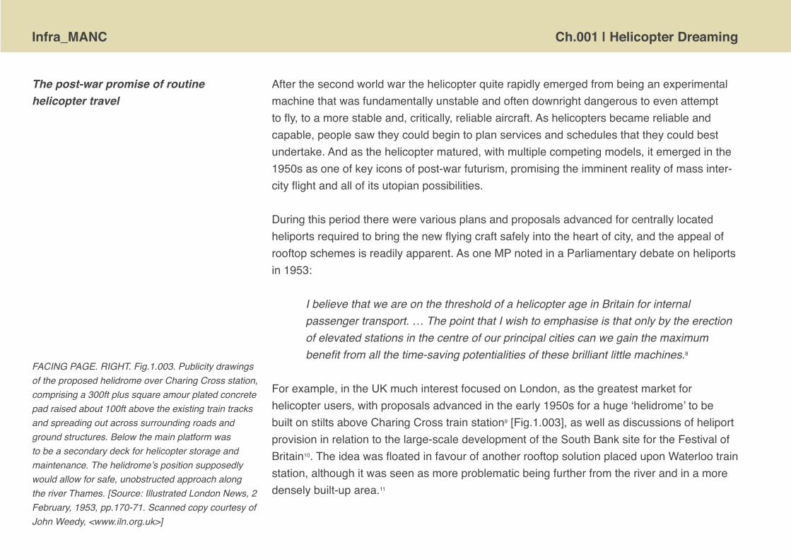
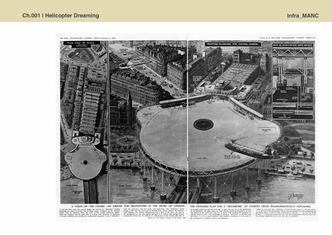
FACING PAGE. RIGHT. Fig.1.003. Publicity drawings of the proposed helidrome over Charing Cross station, comprising a 300ft plus square amour plated concrete pad raised about 100ft above the existing train tracks and spreading out across surrounding roads and ground structures. Below the main platform was to be a secondary deck for helicopter storage and maintenance. The helidrome’s position supposedly would allow for safe, unobstructed approach along the river Thames. [Source: Illustrated London News, 2 February, 1953, pp.170-71. Scanned copy courtesy of John Weedy, <www.iln.org.uk>]
Ch.001 | Helicopter Dreaming Infra_MANC

Infra_MANC Ch.001 | Helicopter Dreaming
ItisunclearhowrealisticorrealisabletheschemesforWaterlooandCharingCrossstationswereandtheymayhavebeenarchitecturaldreamsmuchlikeManchester’srooftopschemes.IntheendasupposedlytemporaryhelipadwaserectedascantileveredplatformoutovertheRiverThamesatBattersea[1959]andremainsinoperation.12
Itisapparentthathelipadsonthetopofbuildingsarenotascommonaspopularlyimagined.Theroofsofskyscrapersarenotroutinelydottedthe‘H’landingsigns.Thisisduetothelackofdemandandfinancialfeasibility,perceivedsafetyrisksandsecurityconcerns[significantlyenhancedpost9-11],alongwithpragmaticreasonsinthatmanyroofsaretoosmalloroddshaped,andthatthespaceisoftenrequiredforHVACmachineryandvaluabletelecommunicationsequipment.NoneofthetallbuildingsinManchestercitycentreareequippedwithahelipadtothebestofourknowledge.
Perhapsthemosticonicskyscraperhelipad–celebratedindramaticphotographsofhelicoptersswoopingintoland–waslocatedonGropiusandBelluschi’s60storeyPanAmBuildinginmidtownManhattan.[Fig.1.004]Thisisnolongerinuseandisforeverknownforanaccidentthatoccurredin1977.Thehelipadhadopenedin1965andoperatedshuttleflightstonearbyairports,butclosedin1968asitwasunprofitable13.ThepadwasreactivatedforflightsinFebruary1977butinMaythatyearastationaryhelicoptersufferedamechanicalfailureinitslandinggear,collapsedtothedeckbreakingfreeoneoftherotorblades.‘Whirlinglikeagiganticboomerangthebladestruckfourpeopleontherooftoplandingpad,killingthreeinstantly,thenplungedovertheskyscraper’swestparapet.…Onepieceofbladecontinuedtofall,whirlingontoMadisonAvenueandkillingawomanwalkingonMadisonand43rdStreetshortlyafter5.30pm’.14Thehelipadwaspermanentlyclosedaftertheincident. ABOVE. Fig.1.004. Design model for the distinctive
form of the Pan Am building, illustrating its celebrated capability to handle helicopter landings on the flat roof deck. [Source: Erick Christian Alvarez Soto, <http://www.flickr.com/photos/8534413@N03/4272148131/>]
Ch.001 | Helicopter Dreaming Infra_MANC
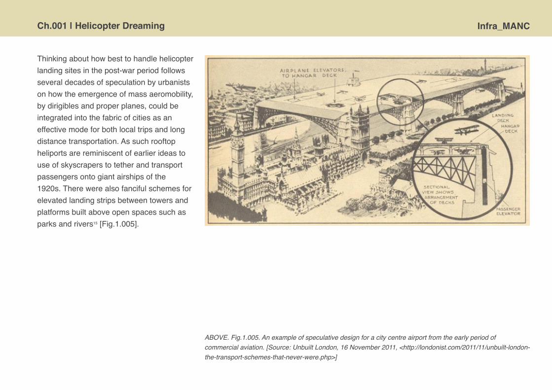
Thinkingabouthowbesttohandlehelicopterlandingsitesinthepost-warperiodfollowsseveraldecadesofspeculationbyurbanistsonhowtheemergenceofmassaeromobility,bydirigiblesandproperplanes,couldbeintegratedintothefabricofcitiesasaneffectivemodeforbothlocaltripsandlongdistancetransportation.Assuchrooftopheliportsarereminiscentofearlierideastouseofskyscraperstotetherandtransportpassengersontogiantairshipsofthe1920s.Therewerealsofancifulschemesforelevatedlandingstripsbetweentowersandplatformsbuiltaboveopenspacessuchasparksandrivers15[Fig.1.005].
ABOVE. Fig.1.005. An example of speculative design for a city centre airport from the early period of commercial aviation. [Source: Unbuilt London, 16 November 2011, <http://londonist.com/2011/11/unbuilt-london-the-transport-schemes-that-never-were.php>]

Infra_MANC Ch.001 | Helicopter Dreaming
However,themajorconcernwasnotreallythephysicalarchitecturetosupporthelicoptersbuttheneedtodevelopaneconomicarchitecturethatwouldmakeregularpassengerservicesprofitableforairlines.Whiletherewashopeofputtingtogetheraplausiblelookingnetworkofscheduledinter-cityflightsintheUKatthestartofthe1950s,itwasverymuchmoredifficulttomakethenumbersstack-up[Fig.1.006].Therewasmuchanticipationforthesuccessfuldevelopmentoftwin-enginemachineswhichwouldallowforsupposedlysaferoperationsoverbuiltupareasand,crucially,havesufficientloadcarryingcapacitytolowertheperpassengermilecosts.In1952BritishEuropeanAirways[BEA]chiefexecutivestatedtheirbroadrequirementsforcommerciallyviableserviceswerefor‘largemulti-enginedhelicoptercapableofcruisingatnotlessthan150mphandofferingbetween40-70passengerseatsby1960.’16
ABOVE. Fig.1.006. Outline network of inter-city passenger helicopter services proposed for the mid 1950s [left]. Calculations of the costs of helicopter travel [BEALine Bus] relative to competing modes of transports, the train and aeroplane [Discovery] [right]. The BEALine Bus helicopter was proposed to carry 48 passengers. [Source: ‘The commercial future of helicopters’, Flight, 14 November 1952, pp.622-623]

Ch.001 | Helicopter Dreaming Infra_MANC
Manchester’s aero-urbanism
The ideal would, I think, be a roof top site situated at the city centre or midway between the business and shopping centres …... It is unlikely that we should find a suitably stressed building or a building of suitable landing area size, and if one was to be built the higher it was the more suitable would it be for landing helicopters.17
Manchesterwasahubforearlyinnovationsinaviationatthestartofthenineteenthcentury,withoneofthefirstlongdistancepoweredflightsfromLiverpoollandinginanairfieldatTraffordPark.Throughthefirstfewdecadesofaviationdevelopment,fromexperimenttopracticaltransportation,ManchesterCorporationsoughttofindtheidealplaceforanairport.Arangeofdifferentspacesservedastemporarylandingsitesandimprovisedaerodromesforemergingpassengerservices.AftertheTraffordParkairfieldwasdiscontinuedin1916,flightslandedatasitenearMauldethRoadthatdevelopedintotheAlexandraParkaerodrome[operatedfrom1917-24].Inthe1920sanairfieldwasdevelopedsouthofStockportatWoodford[thatstillexistsandserveslightaircraft]beforeswitchingtothenorthwestofthecitywhenlandatBartonbecamethecity’sfirstrealairport,openinJanuary1930.However,groundconditionsandlocalweatherpatternsweredeemedunfavourableatBartoninthe1930sasaviationgrewineconomicscaleandtheaircraftbecamesignificantlylarger.ManchesterCorporationshifteditsaviationactivitybacktosouthofthecityanddevelopedtheRingwaysite.ThroughoutthesedecadesthepoliticiansandofficersofthecouncilwereproactiveinthedevelopmentofaviationandseekingtokeepManchesterattheforefrontofthisemergingmodeoftransport.
AfterthesecondworldwarManchestersoughttoenactlargescalephysicalchangetothespatialstructureofthecitytotackletheimmediateeffectsofbombdamage,andmoreimportantly,withthegoalofovercomingthenineteenthcenturylegacyofrapidandunplannedurbanisation.TheobjectivestoremakeManchesterasamoremodernandefficientlyorderedcityweremadetangibleinthevariousplanspromulgatedbytheCorporation,suchasthe1945 City of Manchester Plan, 1947 South Lancashire and North Cheshire Advisory Planning Committee: An Advisory Plan18andsubsequentlyinslumclearancesandhousingstrategies,land-usezoningandtransportschemesthroughthe1950s.

Infra_MANC Ch.001 | Helicopter Dreaming
Akeyelementinthesepost-warplanswastoreconfigurethecommunicationsystemsofthecity:torationalisetherailsystemandprovideasinglelargepassengerstation[codenamed‘Trinity’andlocatedabovetheRiverIrwell],andtosignificantlyreduceroadcongestionwithamajordualcarriagewayrightaroundthecitycentre,joinedbyradialexpresswaystoaseriesofnewringroadsatvaryingdistancesfromthecore.19
Aviationwasalsosignificanttothefuturedevelopmentofthecityandisfeaturedinthe1945 City of Manchester Planand1952 Development Plan,withanemphasisonexpandingandenhancingRingwayairportanditsconnectivitytothecity.The1945 City of Manchester Plan onlymakesmentionofhelicoptersinpassing–theywerestillhighlyexperimentalvehiclesatthatpoint–notingthat‘[w]emustbereadyforadevelopmentofrotoraircraft..Thesemaybelandedandservicedonlargebuildingsoronsmallplaneparksinthecitycentre.’20Withinafewyearshelicopters,asaviablemeansofpassengertransport,wereonthehorizonandinthesummerof1951aseriesofshortreportsintheManchester GuardiannewspaperindicatethatofficersoftheCityCorporationwerebeginningtoconsiderthevalueinprovidingasuitablelandingsiteforhelicoptersandwerehavingmeetingswithrepresentativesfromBritishEuropeanAirways[BEA],whowereplanninginter-citypassengerhelicopterservices21. ThisactivitywaspartlyinresponsetomissivescomingfromtheWhitehallMinistryofCivilTransporttocityauthoritiestopreparesiteshelicopterservices.22InacommentaryintheManchester GuardianonthepotentialforregularhelicopterflightsbetweenmajorBritishcities,thecorrespondentnotedthat:
…the convenience and economy of any such service will call for a city landing ground almost as centrally sited as the main railway stations. News that the siting of a Manchester helicopter station is shortly to be discussed with the specialists of the BEA …. gives further assurance that an appropriate space is likely to be earmarked against the needs of a new service from which the city could hardly be excluded.23
Ch.001 | Helicopter Dreaming Infra_MANC
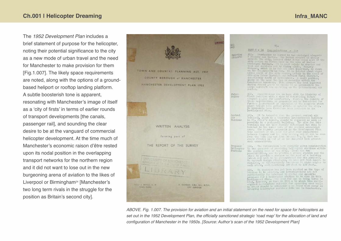
The 1952 Development Planincludesabriefstatementofpurposeforthehelicopter,notingtheirpotentialsignificancetothecityasanewmodeofurbantravelandtheneedforManchestertomakeprovisionforthem[Fig.1.007].Thelikelyspacerequirementsarenoted,alongwiththeoptionsofaground-basedheliportorrooftoplandingplatform.Asubtleboosterishtoneisapparent,resonatingwithManchester’simageofitselfasa‘cityoffirsts’intermsofearlierroundsoftransportdevelopments[thecanals,passengerrail],andsoundingthecleardesiretobeatthevanguardofcommercialhelicopterdevelopment.AtthetimemuchofManchester’seconomicraisond’êtreresteduponitsnodalpositionintheoverlappingtransportnetworksforthenorthernregionanditdidnotwanttoloseoutinthenewburgeoningarenaofaviationtothelikesofLiverpoolorBirmingham24[Manchester’stwolongtermrivalsinthestruggleforthepositionasBritain’ssecondcity].
ABOVE. Fig. 1.007. The provision for aviation and an initial statement on the need for space for helicopters as set out in the 1952 Development Plan, the officially sanctioned strategic ‘road map’ for the allocation of land and configuration of Manchester in the 1950s. [Source: Author’s scan of the 1952 Development Plan]

Infra_MANC Ch.001 | Helicopter Dreaming
Afascinating‘left-field’interventioninthenascentplanningintheearly1950sforaheliportincentralManchesterwasmadebyJ.J.Spyra,anengineerworkingforcivilengineeringconsultantsTaylor&Whalley.Spyrasetoutaproposalforarooftopheliportonapurpose-builtnewtowerstructureinthemiddleofManchester;thisseemstohavebeenanentirelyspeculativescheme.25TheAirportCommitteeofManchesterCorporationnoteintheirminutesthereceiptofSpyra’sproposalbutitdoesnotseemtohavebeenseriouslyconsideredandisnotreferredtoatallinthesubsequentdeliberationsthroughthe1950sonahelicopterstationinthecitycentre.
Spyra’s1951schemecalledforafourteenstoreycylindricalbuilding,positionedonavacantbomb-damagedsiteoffCorporationStreetwitharectangularhelicopterlandingdeckontheroof[Fig.1.008].Pre-emptiveoftheeraoftheComprehensiveDevelopmentAreaandtheresultantmegastructures,thecomplexreservedfivefloorsfora250bedhotel,alongwithextensiveretailandleisurefacilitiesandbasementcarparking;theupperfloors-subjecttomostnoisedisturbance–wereproposedasamixtureofoffices,showroomsandstockrooms.Presumablythelatterwouldbeattheverytoptoattenuatesoundtothefloorsbelow.Theestimatedcostforconstructionwasreportedas£1.5millionanditsverticalscaleandphysicalmassingmeanitwouldhavedwarfedtheneighbouringpre-warcommercialbuildings,includingtheCornExchangeandeasilyovershadowedthecathedral.26 The cantileveredflatroofforlandingwouldhavebeenvisuallystrikingbutitalsohadareal‘Thunderbirds’styledramaasthewholeplatformwould‘…beonaturntable,sothatitcanberotatedintotheprevailingwindtoprovidearun-in300feetlong.’27Thiswouldhavebeenasighttosee–amassivemoveableflightdeckandhelicoptersbuzzingrightintotheheartofthecitycentre.
ABOVE. Fig.1.008. Sketch of the rooftop helicopter terminus in Manchester proposed by J.J. Spyra in 1951. [Source: Author’s scan, untitled article, Manchester Guardian, 1 November 1951, p.8]

Ch.001 | Helicopter Dreaming Infra_MANC
FiveyearsafterJ.J.Spyra’sschemewasputforwardthereappearsanotherdramaticandequallyspeculativeproposalforarooftophelicopterstationinManchester,thistimetobebuiltonanexistingstructureandinterestinglytheideaemanatedfromwithintheCorporationitselfratherthanexternalconsultants.TheproposalwastoaddalargelandingplatformoverManchesterVictoriarailwaystation.[Fig.1.009]Itisaccompaniedbyalargearchitecturalperspectivedrawing,withcolourful,cartoon-like,helicoptersbusilybuzzingaroundamodernlookingheliport.28 [Fig.1.010]
RIGHT. Fig.1.009. Heliport on Manchester Victoria Station, R Nicholas, City Surveyor, undated. [Source: Ref. GB127.M723/82, Greater Manchester County Record Office with Manchester Archives. Author’s photograph, courtesy of Manchester Archives]

Infra_MANC Ch.001 | Helicopter Dreaming

Ch.001 | Helicopter Dreaming Infra_MANC
FACING PAGE. LEFT. Fig.1.010. City of Manchester - Heliport - near Victoria Station, R Nicholas, City Surveyor. Drawn by Sidney R. Fisher, 1956. [Source: Ref. GB127.M723/81, Greater Manchester County Record Office with Manchester Archives. Author’s photograph, courtesy of Manchester Archives]
TheoriginoftheplanisclearlyfromtheManchesterCorporationasisitnotarisedbyR.Nicholas,thepowerfulcityengineerandsurveyorforovertwentyyearsfromthemid1940suntil1963.TheperspectivedrawingisalsomarkedwithNicholas’nameandcarriestheartist’ssignatureaswellinthebottomright-handcorner.However,theschemeitselfisnotcitedinanyofthehelicoptersubcommittee’sdiscussionsthroughoutthe1950sonheliportsites[includingpossiblerooftoputilisation],norisitmentionedintheManchester Guardian reportingofthedeliberationsofthecorporationaboutahelicopterstationinthecity.[Thesedeliberationsareconsideredbelow.]Thus,theactualcontextforwhichtheproposalwasconceivedremainratherpuzzling.Theartefactsthemselveshavelittleinthewayofinformationandareonlydatedbytheartist’sinscriptionwhichappearstoread‘56’andtangentiallythroughtheparticularhelicoptermodelsshownwhichmatchthistimeperiod.TheplanandperspectivedrawingformpartofasubstantialcollectionofarchivalmaterialfromtheManchesterCorporation’sCityEngineersandSurveyorsDepartmentworkingrecordsthatwere‘rescued’fromdeterioratingconditionsinTownHallatticareasin2005bythearchivist.Duringthistransfertheplananddrawingmayhavebecomedissociatedfromotheroriginalmaterials.29
Thephysicalformatandaestheticstyleoftheplansuggeststhatitwascreatedforapubliceventorexhibition.[Fig.1.009]Thedrawingresonateswithasenseofactionandfunandistosomeextentindicativethatwhatwasbeingshownwasaspeculativeschemeandneverintendedtobetakenseriously.Certainlytheuseofthecomicfonts,theexaggeratedmonosyllabictitle,thedistinctivenortharrowandthestylisedscalebararenotinkeepingwiththenormallyformalandfunctionalplanaestheticofCityEngineersandSurveyorsDepartment[forexampleseeFigs.1.021,and1.022below].Andyettheplanandperspectivedrawingseemtobemorethanmerefiveminutedoodlesexecutedbyanapprentice,theyappeartobetheresultofsomethoughtandeffort.Moreover,asseen,similarrooftopdesigns
Infra_MANC Ch.001 | Helicopter Dreaming
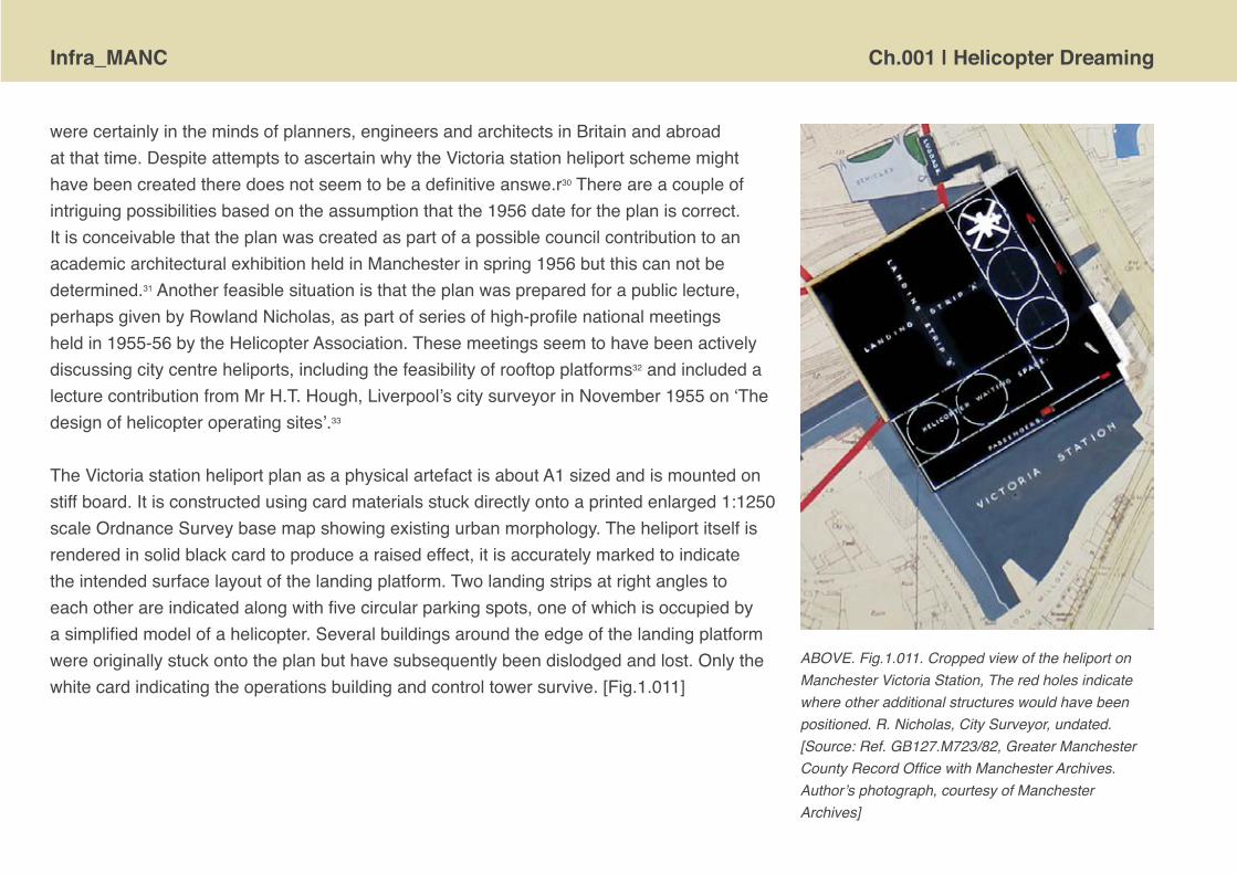
werecertainlyinthemindsofplanners,engineersandarchitectsinBritainandabroadatthattime.DespiteattemptstoascertainwhytheVictoriastationheliportschememighthavebeencreatedtheredoesnotseemtobeadefinitiveanswe.r30Thereareacoupleofintriguingpossibilitiesbasedontheassumptionthatthe1956datefortheplaniscorrect.ItisconceivablethattheplanwascreatedaspartofapossiblecouncilcontributiontoanacademicarchitecturalexhibitionheldinManchesterinspring1956butthiscannotbedetermined.31Anotherfeasiblesituationisthattheplanwaspreparedforapubliclecture,perhapsgivenbyRowlandNicholas,aspartofseriesofhigh-profilenationalmeetingsheldin1955-56bytheHelicopterAssociation.Thesemeetingsseemtohavebeenactivelydiscussingcitycentreheliports,includingthefeasibilityofrooftopplatforms32andincludedalecturecontributionfromMrH.T.Hough,Liverpool’scitysurveyorinNovember1955on‘Thedesignofhelicopteroperatingsites’.33
TheVictoriastationheliportplanasaphysicalartefactisaboutA1sizedandismountedonstiffboard.Itisconstructedusingcardmaterialsstuckdirectlyontoaprintedenlarged1:1250scaleOrdnanceSurveybasemapshowingexistingurbanmorphology.Theheliportitselfisrenderedinsolidblackcardtoproducearaisedeffect,itisaccuratelymarkedtoindicatetheintendedsurfacelayoutofthelandingplatform.Twolandingstripsatrightanglestoeachotherareindicatedalongwithfivecircularparkingspots,oneofwhichisoccupiedbyasimplifiedmodelofahelicopter.Severalbuildingsaroundtheedgeofthelandingplatformwereoriginallystuckontotheplanbuthavesubsequentlybeendislodgedandlost.Onlythewhitecardindicatingtheoperationsbuildingandcontroltowersurvive.[Fig.1.011]
ABOVE. Fig.1.011. Cropped view of the heliport on Manchester Victoria Station, The red holes indicate where other additional structures would have been positioned. R. Nicholas, City Surveyor, undated. [Source: Ref. GB127.M723/82, Greater Manchester County Record Office with Manchester Archives. Author’s photograph, courtesy of Manchester Archives]

Ch.001 | Helicopter Dreaming Infra_MANC
TheheliportcoversasubstantialportionofVictoriastationandappearstoshowanewluggagehandlingbuildingandvehicleaccess/drop-offareaoffromNewBridgeStreet.Yet,theplan,inoverallimpression,isdominatedvisuallymorebythefunnelshapedapproachpathsthanthelandingsiteitself.Thedivergingredlinesshowtheroutesalongwhichthehelicopterswouldapproach,indicatedwiththeirdramaticsweptbackarrowheads.ThedirectionsarefromnorthwestandsouthwestandmeantthatnoisyhelicopterswouldnotapproachthestationacrossthecitycentreitselfbutcomeinoverSalfordandTrafford!Whiletheflightplanesareshownastwodimensionallanesontheplantheywouldactuallyhavebeenthree-dimensionalfunnelshapedspacethatprojectoutwardsandupwards–giventheirmechanicalcapacityitwasenvisagedthathelicopterswouldglideintolandingalongagraduallyslopingpathanddepartagainupaninclinedrouteofabout1in10angleforefficiencyandsafety.ItwasnotintendedthathelicopterswouldhoverdirectlyoverheadandundertakeVTOLoperations.
Besidestheheliportlandingsiteandtheflightplanes,thedesigneroftheplanhascuriouslychosentohighlightthepresenceoftheriversIrwellandIrkwiththeadditionofbluecolourcard.[Perhapsthiswasmeantasanaidtovisuallyorientatethereader.]Theonlybuildings,otherthantheheliportitself,whicharehighlightedisthenamingofExchangetrainstationandthedetailingofthecathedralwiththeadditionofcolouredcard.Anirregularlyshapedbubbleoflightshadingalsoencompassestheheliportzoneofoperationsandthismayhavebeenanotionalnoiseenvelopeindicatingtheareasofdisturbance;orperhapsjustaestheticlicenseonthepartofthedraughtsperson?Aswellasthedistinctivetypography,anotherprominentvisualfeaturerelatingtothetopographyoftheareaistheskeletalframeofmajornewroadsthatwerebeingplannedatthetime.Theirprojectedalignmentsarestronglyhighlightedontopoftheexistingbasemapandtheirwidthandsmoothcurvesmakeanimplicitpromiseofeasierandfastertrafficmovement.Theylookliketheycouldeasilybecomereal.34Sucharterialroadschemesalsoresonaterhetoricallywiththeprojectednewuseforthetrainstationasarouteintotheairandthusintothefutureforurbantransportation.Instrikingcontrasttherailwaylinesarethin,faintgreylines,fadingintothebackground-theyaretheroutesofthepast.
Accompanyingthetechnicaldetailoftheplanisamoreimpressionistic,butstillinformative,three-dimensionaldrawingwhichtriestorenderhowtheheliportmightlookinoperation.TheviewingperspectiveisfromanelevatedpositionontheedgeofSalford,lookingnortheast.ItisapproximatelyA1sized,withadditionshand-drawnandpaintedingouacheontoaprinted,pre-existing,blackandwhitecityscape.Theadditionofcolourbringsthescenealiveandgivesthehelicopters,inparticular,asenseofnovelty.Thetitleandcaptionatthebottomarewritteninsmall,free-handletteringsuggestingtheywereonlytemporarylabelsandperhapsthedrawingitselfwasmeanttobemountedwithproperlyprintedtext.Thecreator’snameissmallandillegible,butappearstoreadSydney.R.Fisher.

Infra_MANC Ch.001 | Helicopter Dreaming
Theforegroundofthedrawingisdominatedbydark,gorge-like,Irwellriverandajumbleofgenericlookingindustrialbuildingsandchimneys,withrisingwispsofsmoke,whicharebeingspeedilytraversedbyabrightyellowtwin-enginehelicopterwithwhirlingrotorblades[thisislikelybasedonaBristoltype173Mk2helicopterbecauseofitscharacteristicforeandaftstubwings,andupstandingfinsontheaftwingtips;seeFig.1.013].Therealismofthescenehasbeenenhancedbytheadditionofashadoweffectbelowthehelicopter.ThesweepingrouteofdenselyclusteredrailwaylinesandelongatedroofoftheExchangetrainstationcutsadiagonalswatheacrossthecentreofthedrawing,withthecathedralbehindamidstanindistinguishablemassofcommercialbuildings.
RIGHT. Fig.1.012. Cropped, close-up view. City of Manchester - Heliport - near Victoria Station, R. Nicholas, City Surveyor. Drawn by Sidney R. Fisher, 1956. [Source: Ref. GB127.M723/81, Greater Manchester County Record Office with Manchester Archives. Authors photograph, courtesy of Manchester Archives]

Ch.001 | Helicopter Dreaming Infra_MANC
RIGHT. Fig.1.013. Contemporary photographs of the main commercial helicopters available in the mid 1950s.
[a] The single-engine, 3 wheel Bristol 171, known as the ‘Sycamore’. [Source: <http://en.wikipedia.org/wiki/File:BEA_Bristol_171_Sycamore_at_London_Gatwick.jpg>]
[b] The single-engine, 4 wheeled Westland-Sikorsky S-55. [Source: <http://industrialnews.industrialartifactsreview.com/News_Photos/aviation/ 1950s/1957_New_York_Airways_Sikorsky_S-55_xlg.htm>]
[c] The two-engine, dual rotor Bristol type 173, Mk 2. [Source: <http://www.aviationarchive.org.uk/Gpages/html/G2014.html>]
[d] The Fairey Rotodyne hybrid. [Source: <http://www.flickr.com/photos/30562117@N02/3107721270/in/photostream/>]

Infra_MANC Ch.001 | Helicopter Dreaming
Theheliportproperispositionedofftoleftofcentreofthedrawingandhasbeencarefullyrenderedtoco-existwiththeactualstationarchitecture.Thelandingplatformisbuzzingwithsimultaneoushelicopteractivity–farinexcessofwhatitwouldhavebeencapableofsafelyhandling!Therearetwohelicoptersshownontheapron,alargeyellowtwin-enginedoneappearstobeloadingluggageandasmallerbluevehicleisparkedandperhapsdisembarkingherpassengers.Yetasecondbluehelicopterisalsoshownasjusttakingoffandsurelyitspowerfulrotordownwashwouldhaveknockedthosepassengersover![ThesetwobluecolouredhelicoptersarelikelytobemodelledonWestland-SikorskytypeS-55,seeFig.1.013b.]Hoveringoverheadisasmallerredhelicopter–perhapswaitingtoland?[ThisislikelytohavebeenmodelledonthesmallerBristoltype171‘Sycamore’helicopter,seeFig.1.013a].
Theheliportisshownwithasubstantialpassengerhandlingbuildingalongonesideofthelandingplatform,designedwithadistinctive‘Festival’erawavyroofformandalarge‘Heliport’signabovetheexistingmainentrancetothetrainstation.Ontheoppositesideoftheplatformistheoperationsbuildingandaslightlytallercontroltowermarkedwithwarningyellowpaint.Onthelefthandsideoftheplatformisaviewofthestairwaydowntothenewluggagehandlingbuildingandtheconcreteapronofthevehicledrop-offpoint.Theplanandtheperspectivedrawingdonotshowthesameconfigurationofelementsinthisareaandthiswouldsuggestahurriedpreparationofthescheme.Theexistingrooflineofthetrainstationcanbeseenofftotheright-handsideofthelandingdeck.TheoverallaesthetichassomeparallelstothatoftheCharingCrossstationheliportdrawingsproducedafewyears[seeFig.1.003above].
Neitherdrawingistypicalofarchitecturalconventionswhichwerestillbasedonplanandaxonometricandperspectiveprojection,montageasatechniqueinarchitecturalrepresentationwouldonlyreallyrisetoprominenceinthe1960s.Thevisualcontrastsintheoutlookofthedrawingarguablyspeakoftheage,atimeofseeminglydramatictechnologicalchangeandtheemergenceofmanynewconsumeristopportunities–affordabledomesticappliances,risingautomobileownership,theemergenceoftelevision.Thereisthedrabmonochromecharactertotheexistingurbanfabricofmature,almostmoribund,Manchester.Thesmokestacksandstaticsteamtrainsasmotifsoftheindustrialpastaresetagainstnewmotorcarsandthebrightlycoloured,energisedandmobilehelicoptersinthesky.Themodern,whitecleansurfaceoftheheliportliterallyandmetaphoricallyoverlays–andalmostseemstosupersede–thetrainstation,cathedraltotechnologicalprogressinthenineteenthcenturycity.Thefuturehasarrivednotontherails,butfromtheairabove.

Ch.001 | Helicopter Dreaming Infra_MANC
The Manchester heliport deliberations WhilsttheschemesforrooftopheliportsonVictoriaStationandtheSpyratowerwerehighlyspeculativeideas,thecityauthoritiesweregivingseriousscrutinytoarangeofgroundlevelsitessuitableforusebypassengerhelicoptersinthemid1950s.Sitesbeingidentifiedwereinaninnerringofvacantplotsandsemi-derelict,redundantspaceswithinaboutamileofthecitycentre[Fig.1.014].Deliberationscontinuedoverseveralyears,seekingtoascertainthemostpropitioussiteofferingsufficientunobstructedspaceandbeingascloseaspossibletothecitycentre,butalsoneedingtomitigateagainstthepotentiallossoflandvalueandnegativeexternalitiesfromaircraftnoiseanddisturbance.Byearly1955thehelicoptersubcommitteeofManchesterCorporation’sAirportCommitteewasconsideringa‘long-list’ofelevendifferentsitesforaheliport[Table1].Allwereatgroundleveland,intriguingly,inallthedetaileddiscussionsduring1954-55therewasnomentionatallofVictoriaStationasapossiblecontenderforarooftoplandingplatform.Astheynote,‘[t]hecommitteealsoconsideredwhetherlandingareasforCityCentresshouldbeonthegroundoronrooftopsitesandtheyconcludedthatgroundsiteswhichcanbedevelopedatlittlecostshouldbeusedatfirst.’35Thereis,however,somediscussionofthepotentialoftheroofoftheBritishRailgoodswarehousebetweenDeansgateandWatsonStreetasalandingsitebutthiswassummarilydismissedinMay1954duetothelikelyhighcostsofconversionandthefactthatitssizewasinsufficienttomeettheminimumspacerequirementsspeltoutbytheMinistryofCivilTransportatthetime.36

Infra_MANC Ch.001 | Helicopter Dreaming
Table 1 Helicopterstation:possiblesitesfordevelopment:37
1. DerbyStreet,nearWaterlooRoad.2. SherborneStreet.3. BrickworksclaypitoffNorthStreet [CheethamHill].[Queen’sRoadtip]4. MillerStreet.5. Piccadilly.6. PortlandStreet.7. St.AndrewsStreet.[TravisStreet, Ardwick]8. BrookStreet/SidneyStreet.9. MedlockStreet/GeorgeStreet.10. Castlefield.11. WaterStreet/QuayStreet.
LEFT. Fig.1.014. An original index map of the locations of the eleven possible sites for a helicopter station under consideration by Manchester corporation in the mid 1950s. [Source: City Surveyor and Engineers plan archive, ref. 3260/-/13, GMCRO. Authors scans, courtesy of Manchester Archives and GMCRO]
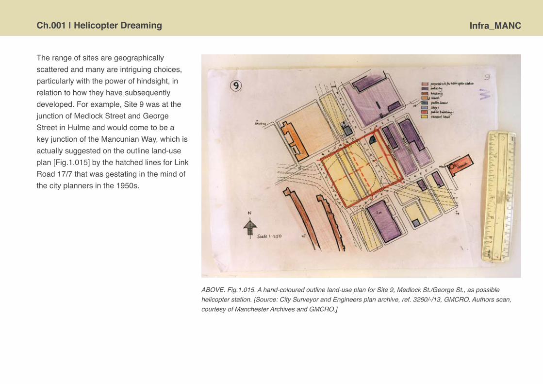
Ch.001 | Helicopter Dreaming Infra_MANC
Therangeofsitesaregeographicallyscatteredandmanyareintriguingchoices,particularlywiththepowerofhindsight,inrelationtohowtheyhavesubsequentlydeveloped.Forexample,Site9wasatthejunctionofMedlockStreetandGeorgeStreetinHulmeandwouldcometobeakeyjunctionoftheMancunianWay,whichisactuallysuggestedontheoutlineland-useplan[Fig.1.015]bythehatchedlinesforLinkRoad17/7thatwasgestatinginthemindofthecityplannersinthe1950s.
ABOVE. Fig.1.015. A hand-coloured outline land-use plan for Site 9, Medlock St./George St., as possible helicopter station. [Source: City Surveyor and Engineers plan archive, ref. 3260/-/13, GMCRO. Authors scan, courtesy of Manchester Archives and GMCRO.]
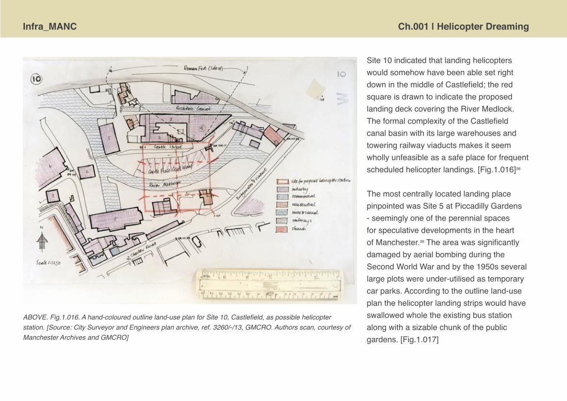
Infra_MANC Ch.001 | Helicopter Dreaming
Site10indicatedthatlandinghelicopterswouldsomehowhavebeenablesetrightdowninthemiddleofCastlefield;theredsquareisdrawntoindicatetheproposedlandingdeckcoveringtheRiverMedlock.TheformalcomplexityoftheCastlefieldcanalbasinwithitslargewarehousesandtoweringrailwayviaductsmakesitseemwhollyunfeasibleasasafeplaceforfrequentscheduledhelicopterlandings.[Fig.1.016]38
ThemostcentrallylocatedlandingplacepinpointedwasSite5atPiccadillyGardens-seeminglyoneoftheperennialspacesforspeculativedevelopmentsintheheartofManchester.39TheareawassignificantlydamagedbyaerialbombingduringtheSecondWorldWarandbythe1950sseverallargeplotswereunder-utilisedastemporarycarparks.Accordingtotheoutlineland-useplanthehelicopterlandingstripswouldhaveswallowedwholetheexistingbusstationalongwithasizablechunkofthepublicgardens.[Fig.1.017]
ABOVE. Fig.1.016. A hand-coloured outline land-use plan for Site 10, Castlefield, as possible helicopter station. [Source: City Surveyor and Engineers plan archive, ref. 3260/-/13, GMCRO. Authors scan, courtesy of Manchester Archives and GMCRO]
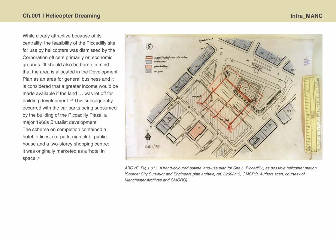
Ch.001 | Helicopter Dreaming Infra_MANC
Whileclearlyattractivebecauseofitscentrality,thefeasibilityofthePiccadillysiteforusebyhelicopterswasdismissedbytheCorporationofficersprimarilyoneconomicgrounds:‘ItshouldalsobeborneinmindthattheareaisallocatedintheDevelopmentPlanasanareaforgeneralbusinessanditisconsideredthatagreaterincomewouldbemadeavailableiftheland…wasletoffforbuildingdevelopment.’40ThissubsequentlyoccurredwiththecarparksbeingsubsumedbythebuildingofthePiccadillyPlaza,amajor1960sBrutalistdevelopment.Theschemeoncompletioncontainedahotel,offices,carpark,nightclub,publichouseandatwo-storeyshoppingcentre;itwasoriginallymarketedasa‘hotelinspace’.41
ABOVE. Fig.1.017. A hand-coloured outline land-use plan for Site 5, Piccadilly., as possible helicopter station. [Source: City Surveyor and Engineers plan archive, ref. 3260/-/13, GMCRO. Authors scan, courtesy of Manchester Archives and GMCRO]
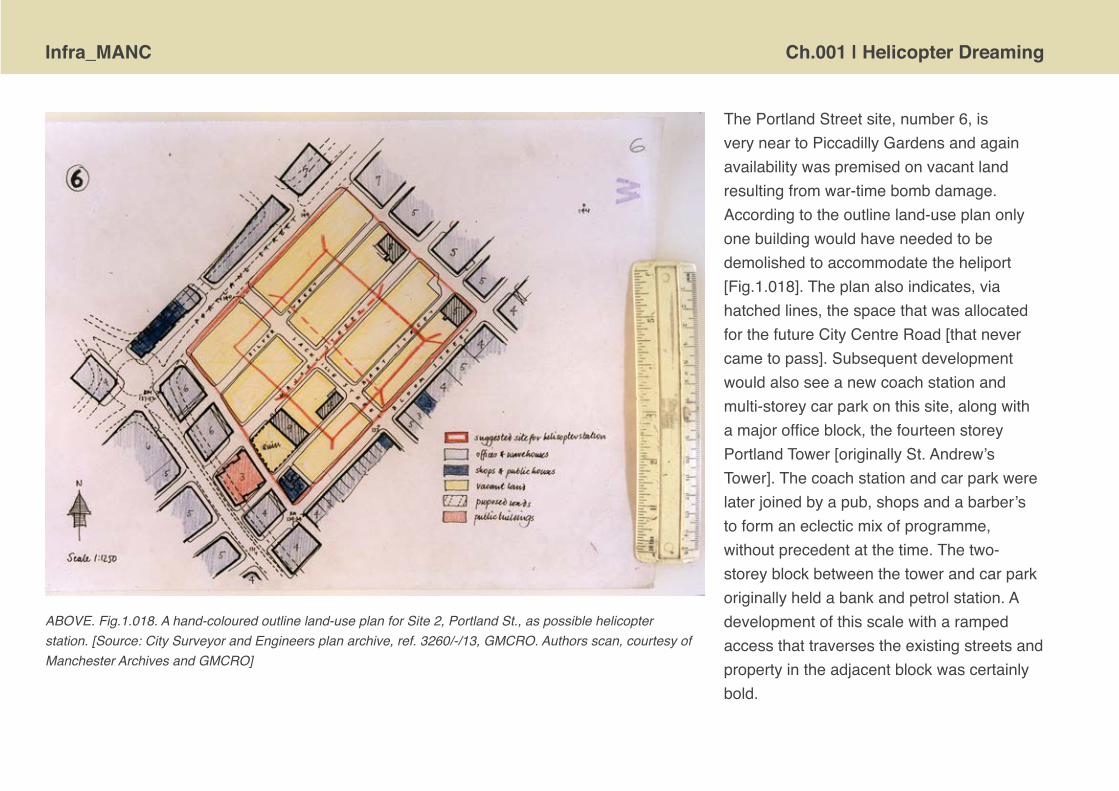
Infra_MANC Ch.001 | Helicopter Dreaming
ThePortlandStreetsite,number6,isveryneartoPiccadillyGardensandagainavailabilitywaspremisedonvacantlandresultingfromwar-timebombdamage.Accordingtotheoutlineland-useplanonlyonebuildingwouldhaveneededtobedemolishedtoaccommodatetheheliport[Fig.1.018].Theplanalsoindicates,viahatchedlines,thespacethatwasallocatedforthefutureCityCentreRoad[thatnevercametopass].Subsequentdevelopmentwouldalsoseeanewcoachstationandmulti-storeycarparkonthissite,alongwithamajorofficeblock,thefourteenstoreyPortlandTower[originallySt.Andrew’sTower].Thecoachstationandcarparkwerelaterjoinedbyapub,shopsandabarber’stoformaneclecticmixofprogramme,withoutprecedentatthetime.Thetwo-storeyblockbetweenthetowerandcarparkoriginallyheldabankandpetrolstation.Adevelopmentofthisscalewitharampedaccessthattraversestheexistingstreetsandpropertyintheadjacentblockwascertainlybold.
ABOVE. Fig.1.018. A hand-coloured outline land-use plan for Site 2, Portland St., as possible helicopter station. [Source: City Surveyor and Engineers plan archive, ref. 3260/-/13, GMCRO. Authors scan, courtesy of Manchester Archives and GMCRO]
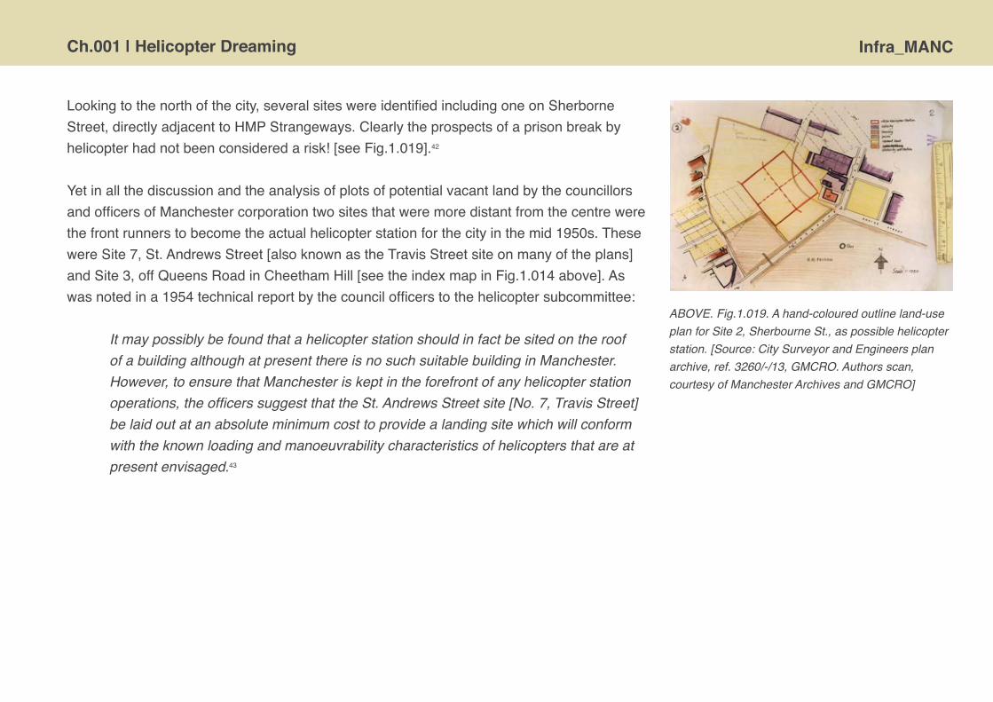
Ch.001 | Helicopter Dreaming Infra_MANC
Lookingtothenorthofthecity,severalsiteswereidentifiedincludingoneonSherborneStreet,directlyadjacenttoHMPStrangeways.Clearlytheprospectsofaprisonbreakbyhelicopterhadnotbeenconsideredarisk![seeFig.1.019].42
YetinallthediscussionandtheanalysisofplotsofpotentialvacantlandbythecouncillorsandofficersofManchestercorporationtwositesthatweremoredistantfromthecentrewerethefrontrunnerstobecometheactualhelicopterstationforthecityinthemid1950s.ThesewereSite7,St.AndrewsStreet[alsoknownastheTravisStreetsiteonmanyoftheplans]andSite3,offQueensRoadinCheethamHill[seetheindexmapinFig.1.014above].Aswasnotedina1954technicalreportbythecouncilofficerstothehelicoptersubcommittee:
It may possibly be found that a helicopter station should in fact be sited on the roof of a building although at present there is no such suitable building in Manchester. However, to ensure that Manchester is kept in the forefront of any helicopter station operations, the officers suggest that the St. Andrews Street site [No. 7, Travis Street] be laid out at an absolute minimum cost to provide a landing site which will conform with the known loading and manoeuvrability characteristics of helicopters that are at present envisaged.43
ABOVE. Fig.1.019. A hand-coloured outline land-use plan for Site 2, Sherbourne St., as possible helicopter station. [Source: City Surveyor and Engineers plan archive, ref. 3260/-/13, GMCRO. Authors scan, courtesy of Manchester Archives and GMCRO]

Infra_MANC Ch.001 | Helicopter Dreaming
ABOVE. Fig.1.020. A hand-coloured outline land-use plan for Site 7, St. Andrews Street / Travis Street, as possible helicopter station. [Source: City Surveyor and Engineers plan archive, ref. 3260/-/13, GMCRO. Author’s scan, courtesy of Manchester Archives and GMCRO]
RIGHT. Fig.1.021. A layout plan for Site 7, St. Andrews Street / Travis Street, April 1953. [Source: City Surveyor and Engineers plan archive, ref. 3260/5/10, GMCRO. Author’s scan, courtesy of Manchester Archives and GMCRO]
Thesentimentisclear-Manchestermustcompetebutatminimumpublicexpenditure!TheSt.AndrewsStreet/TravisStreetsiteseemedthebestcandidate.ItliesonlyafewhundredmetresbeyondPiccadillytrainstation[thenknowasLondonRoad]andwasanareaofmixedindustrialland-useboundedbytherailwayviaductandAncoatsgoodsstation.Bythe1950stheproposedoperationalareawaslargelyclassifiedas‘vacantsites’bytheCitySurveyor[Fig.1.020]andtheonlybuildingthatwouldneededtohavebeendemolishedtoaccommodatethefootprintoftheheliportwouldhavebeenSt.Andrew’sChurch,whichwasreportedtobelargelyredundant.44Asthissitewasviewedasthemostsuitableitwassubject
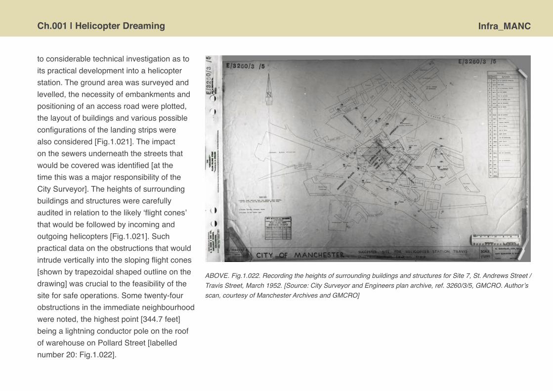
Ch.001 | Helicopter Dreaming Infra_MANC
toconsiderabletechnicalinvestigationastoitspracticaldevelopmentintoahelicopterstation.Thegroundareawassurveyedandlevelled,thenecessityofembankmentsandpositioningofanaccessroadwereplotted,thelayoutofbuildingsandvariouspossibleconfigurationsofthelandingstripswerealsoconsidered[Fig.1.021].Theimpactonthesewersunderneaththestreetsthatwouldbecoveredwasidentified[atthetimethiswasamajorresponsibilityoftheCitySurveyor].Theheightsofsurroundingbuildingsandstructureswerecarefullyauditedinrelationtothelikely‘flightcones’thatwouldbefollowedbyincomingandoutgoinghelicopters[Fig.1.021].Suchpracticaldataontheobstructionsthatwouldintrudeverticallyintotheslopingflightcones[shownbytrapezoidalshapedoutlineonthedrawing]wascrucialtothefeasibilityofthesiteforsafeoperations.Sometwenty-fourobstructionsintheimmediateneighbourhoodwerenoted,thehighestpoint[344.7feet]beingalightningconductorpoleontheroofofwarehouseonPollardStreet[labellednumber20:Fig.1.022].
ABOVE. Fig.1.022. Recording the heights of surrounding buildings and structures for Site 7, St. Andrews Street / Travis Street, March 1952. [Source: City Surveyor and Engineers plan archive, ref. 3260/3/5, GMCRO. Author’s scan, courtesy of Manchester Archives and GMCRO]

Infra_MANC Ch.001 | Helicopter Dreaming
Theextentofpre-planningfortheSt.AndrewsStreet/TravisStreetsiteasapracticalheliportstationisfurtherindicatedbytheenrolmentoftheCityArchitect’sdepartmenttoconceivesomepreliminarysolutionsforterminalbuildingsandancillarystructuresforfuellingandhousingafireappliance.Evidenceoftwopossibleschemeshasthusfarbeenlocatedinthearchives.Initiallydesignswereproducedforaquitesmall,basic,low-coststructuretofacilitatetemporarypassengerhandlingshouldthesiteneedtobemadeoperationalatgreathaste.45MorearchitecturallyinterestingarethedesignsputtogetherbyLeonardHowitt’steamforthesitewithapermanentfourstoreyterminalbuildingcompletewithcontroltower,viewingplatformandanEaglelogoonthefrontelevation[Fig.1.023].Theterminalwasclearlydesignedtohandlesignificantpassengerflowswithspaceseparationofarrivalsanddeparturesloungesandasizablerestaurant.ItisthefamiliarstyleoftheManchesterCorporationArchitect’sDepartment,amanneredandcivilisedelevationaltreatmentthatisnecessarily
ABOVE. Fig.1.023. Extract from elevational drawings for the ‘proposed helicopter rotorstation’ by City Architect, undated [likely 1953/54]. [Source: City Surveyor and Engineers plan archive, ref. 3260/_/8, GMCRO. Author’s scan, courtesy of Manchester Archives and GMCRO]

Ch.001 | Helicopter Dreaming Infra_MANC
efficientwithmaterialsanddetails;thearchitecturalequivalentofutilityfurniture.Itisdefinitelymodern,butnotmodernist.Theorthogonalgeometries,flatroofandwellproportionedfenestrationcharacteriselocalauthoritybuildingduringthisperiodandthisreductive‘Festival’stylemirrorsthatproposedforVictoriaStationroof,butclearlyabsentfromtheseproposalsareanyflamboyantgestures.
In1955theCityCorporation’shelicoptersubcommitteerequestedtotheofficersthattheSt.AndrewsStreet/TravisStreetsitebereservedasthepreferredlocationforManchester’shelicopterstation.46However,withinlessthanayearcircumstanceschangeasnewguidancefromcentralGovernmentontherequiredlandingsizesandscaleoftheapproachflightplanesmeantthatthissitewasnolongerfeasibleandwasdeselected.47
ABOVE. Fig.1.024. Plans for the ‘proposed helicopter rotorstation’ by City Architect, undated [likely 1953/54]. [Source: City Surveyor and Engineers plan archive, ref. 3260/_/8, GMCRO. Authors scan, courtesy of Manchester Archives and GMCRO]
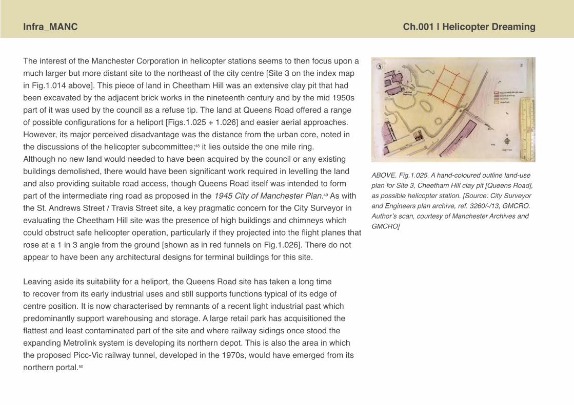
Infra_MANC Ch.001 | Helicopter Dreaming
TheinterestoftheManchesterCorporationinhelicopterstationsseemstothenfocusuponamuchlargerbutmoredistantsitetothenortheastofthecitycentre[Site3ontheindexmapinFig.1.014above].ThispieceoflandinCheethamHillwasanextensiveclaypitthathadbeenexcavatedbytheadjacentbrickworksinthenineteenthcenturyandbythemid1950spartofitwasusedbythecouncilasarefusetip.ThelandatQueensRoadofferedarangeofpossibleconfigurationsforaheliport[Figs.1.025+1.026]andeasieraerialapproaches.However,itsmajorperceiveddisadvantagewasthedistancefromtheurbancore,notedinthediscussionsofthehelicoptersubcommittee;48itliesoutsidetheonemilering.Althoughnonewlandwouldneededtohavebeenacquiredbythecounciloranyexistingbuildingsdemolished,therewouldhavebeensignificantworkrequiredinlevellingthelandandalsoprovidingsuitableroadaccess,thoughQueensRoaditselfwasintendedtoformpartoftheintermediateringroadasproposedinthe1945 City of Manchester Plan.49AswiththeSt.AndrewsStreet/TravisStreetsite,akeypragmaticconcernfortheCitySurveyorinevaluatingtheCheethamHillsitewasthepresenceofhighbuildingsandchimneyswhichcouldobstructsafehelicopteroperation,particularlyiftheyprojectedintotheflightplanesthatroseata1in3anglefromtheground[shownasinredfunnelsonFig.1.026].Theredonotappeartohavebeenanyarchitecturaldesignsforterminalbuildingsforthissite.
Leavingasideitssuitabilityforaheliport,theQueensRoadsitehastakenalongtimetorecoverfromitsearlyindustrialusesandstillsupportsfunctionstypicalofitsedgeofcentreposition.Itisnowcharacterisedbyremnantsofarecentlightindustrialpastwhichpredominantlysupportwarehousingandstorage.AlargeretailparkhasacquisitionedtheflattestandleastcontaminatedpartofthesiteandwhererailwaysidingsoncestoodtheexpandingMetrolinksystemisdevelopingitsnortherndepot.ThisisalsotheareainwhichtheproposedPicc-Vicrailwaytunnel,developedinthe1970s,wouldhaveemergedfromitsnorthernportal.50
ABOVE. Fig.1.025. A hand-coloured outline land-use plan for Site 3, Cheetham Hill clay pit [Queens Road], as possible helicopter station. [Source: City Surveyor and Engineers plan archive, ref. 3260/-/13, GMCRO. Author’s scan, courtesy of Manchester Archives and GMCRO]
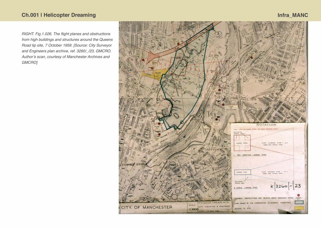
Ch.001 | Helicopter Dreaming Infra_MANC
RIGHT. Fig.1.026. The flight planes and obstructions from high buildings and structures around the Queens Road tip site, 7 October 1959. [Source: City Surveyor and Engineers plan archive, ref. 3260/_/23, GMCRO. Author’s scan, courtesy of Manchester Archives and GMCRO]

Infra_MANC Ch.001 | Helicopter Dreaming
Reality bites and dreams die For my part, I am convinced that the helicopter will be the bird of burden for domestic use in the future. However, I must emphasise the words ‘in the future’ because I do not believe that this is immediately round the corner.51
All enquiries at any time seemed to lead to the conclusion that the commercial future of the heliport was always about twenty years in the future. They were operable for military or emergency purposes or for purposes with a high element of ‘social benefit’ but in terms of normally generated traffic for civilian purposes [whether pleasure or business trips] the costs were relatively high and operating precautions … relatively severe.52
Theabovequotesweremadein1953and1966andbotharestillapplicabletodayasanaccountforthefactthatthevisionofroutine,masshelicopterusefailedtoarrivetorevolutioniseurbantravel.Thefuturethatwasneverdelivered.NothingcameoftheschemesforaheliportinManchesterinthe1950sandbytheearly1960stherealisticprospectsfadedonanationalscaleforcommerciallyviableinter-urbanhelicopterservices.53Asaconsequencesnomajorpurpose-builtcitycentreheliportsseemtohaveconstructedinanyBritishcities,includingManchester.Certainly,therearenospectacularrooftoplandingdecksonmainlinerailwaystations!
Whilethehelicopterdisappearedfromtheurbantransportationradar,commercialaviationhasgrownmassively.WithinManchesterCityCouncilmajoreffortswereexpendedtoupgradeandextendRingwayairportinthe1960s,70s54andagaininthe90s,whichhasarguablyreapedgreateconomicrewardsforthecityandthewiderregioninrecentdecades.55

Ch.001 | Helicopter Dreaming Infra_MANC
IncontemporaryBritishcities,includingManchester,theroleforhelicoptersremainsmarginal.SothenearestpointforregularcommercialhelicopteroperationstoManchestercitycentreisfromtheBartonaerodrome[recentlyrebrandedas‘CityAirportManchester’],whichwasthecity’soriginalairportbackinthe1920s,andisabout9kmfromthecentre.Barton,however,onlyprovidesflightservicesforasmallnumberofelitetravellers,pilotenthusiasts,leisureuserstakinghelicopter‘experiences’andtheemergencyservices.ThemostvisiblepresenceofhelicoptershoveringoverManchesteratpresentarethepoliceairsupportunit’sMDExplorer–callsignX-RayIndia99-thatfliesoutofBartonandtheNorthWestAirAmbulanceservicethatcanlandatthehospitalswithtraumacentres.56Assuchthesoundandsightofhelicoptersintheskiesabovethecitystillattractsattentionasitindicatespotentialtroubleandtraumasomewhereinthestreetsbelow.
Yetthepastdoesnotdeterminefutureplans.Thesituationmightchange,ifplansfortheIntercontinentalHotelTower,57proposedforasiteonWindmillStreettoservicetheadjacentManchesterCentralconventioncentre,getsapprovalandthenitisactuallybuilttoincludethehelipadshownonthedesignmock-upsperhapscommuterhelicoptersbuzzingintothecitycentrewiththebusinesseliteswillbecomeacommonsight[Fig.1.027].InsomesensesthiscontemporaryplanforhotelandhelipadtakesusbacktotheJ.J.Spyrascheme,althoughtheIntercontinentaltowerwoulddwarfthestumpylittletenstoreybuildingof1951-suchisthedevelopmentinskyscrapertechnologyandthedesireforcapitalaccumulationofthelasthalfcentury.
RIGHT. Fig.1.027. Architectural mock-up for 200m InterContinental hotel tower encompassing an crow’s nest helipad at the top. The architect is Roger Stephenson, for The Benmore Group. [Courtesy of Roger Stephenson Architects]

Infra_MANC Ch.001 | Helicopter Dreaming
Thevisionarypossibilitiesoflandingscheduledpassenger-carryhelicoptersontotrainstationstoprovidehighlyintegratedtransportsnodesstillseemslikeanimpossibledream,althoughtraintravellersatManchesterVictoriaarebeingpromisedadramaticnewroofaspartoflongoverdue£20millionupgradetothestationfacilities58 [Fig.1.028].Thelightweightcurvedshellformlinedwithapressurisedpolymer,knownasETFE,certainlywouldnotbeamenabletosafehelicopterlandings!RegardlessofanyfutureproposalsmuchofthespacethatwouldhavehandledhelicoptersisnowoccupiedbytheMENArena[originallynamedtheNYNEXArenaaftertheAmericantelecomsfirmthatsponsoredit],hostingpopstarsandstand-upcomedians,ratherthanSycamoresandSikorsky’s.
RIGHT. Fig.1.028. Digital architectural renders of the planned new roof for Manchester Victoria train station. Design by BDP architects, 2011. [Courtesy of BDP]

Ch.001 | Helicopter Dreaming Infra_MANC
Lookingbeyondscheduledpassengerservices,theprospectsforon-demandpersonalairtravelremainselusivebutstillalluringforsome.Forexamplerecently,AustrianartistFlorianSeidlgarneredsomepositivepresscoverageforhisstylishnewdesignforapod-likeairtaxi[Fig.1.029].HisconceptclearlyresonateswiththepersonalisedhelicopterusageenvisagedinHuxley’sBrave New Worldandtheflying-cardesignsofthe1940s.Thenowwidespreadavailabilityoftoyradio-controlled’coptersmightalsopresagesomebreakthroughs,andrecentlyfirstelectricallypoweredexperimentalhelicopterswereflown.59 Perhapsrealpersonalhelicopterscouldbecloserthanwethinkwithdevelopmentsinlightweightmaterialsmakingtheaerodynamicsfeasibleandsignificantdigitalautomationmakingthemsafelypilotablebyunskilledandinattentivepeople.Maybe,thehelicopterfuturewillarriveoverthehorizonafterall… ABOVE. Fig.1.029. Design concept for a personal
helicopter by Florian Seidl, 2007. [Source: <http://features.conceptcar.co.uk/rca-vehicle-design-2007/seidl.php.>]

Infra_MANC Ch.001 | Helicopter Dreaming
1 Corn,J.J.andHorrigan,B.[1984]Yesterday’s Tomorrow’s: Past Visions of the American Future[Baltimore,MD:TheJohnsHopkinsUniversityPress],p.100.
2 QuotedinCwerner,S.[2009]‘Helipads,heliportsandurbanairspace’inCwerner,S.,Kesselring,S.andUrryJ.[eds.]Aeromobilities[London:Routledge],p.226.
3 deVoogt,A.[2007]Helidrome Architecture[Rotterdam:010Publishers],p.8.
4 Thehelicopterseemstoreceivelittlecoverageintheplanningliterature;althoughseeCwerner,S.[2009]OpCit.;deVoogt,A.[2007]Helidrome Architecture[Rotterdam:010Publishers]; Finch,H.P.[1966]‘Heliportsinurbanareas’in Institution of Civil Engineers Proceedings,33[1],pp.53-63.
5 SeeKoolhaas,R.[1995]‘Thegenericcity’inKoolhaas,R.,Mau,B.andSigler,J.[ed.]S M L XL [Rotterdam:010Publishers].Bouman,M.J.[1996]‘Citiesoftheplane:Airportsinthenetworkedcity’,in Zukowsky,J.,Building for Air Travel[Prestel:Munich],pp.177-194.
6 Cwerner[2009]p.236Opcit.
7 Harding,H.J.B.,[1966]‘Discussiononheliportsinurbanareasandstructuraltestsonanexperimentalhelicopterplatform’,inInstitution of Civil Engineers Proceedings,33[3],p.360.
8 MrGeraldNabarro,MPforKidderminster,HouseofCommonsdebateon‘Helicopterstation,London’,2February1953[Hansard,HCDeb02February1953vol.510cc1615-26],
<http://hansard.millbanksystems.com/commons/1953/feb/02/helicopter-station-london>.9 TheschemewasapparentlyinitiallyadvancedbyMPNormanDoddsinMay1951basedondesignworkbythearchitectsAslanandFreeman[cf.‘Londonrotor-stationdesign’,Flight1953,2January, p.10]andwasfeaturedprominentlyinadoublepagespreadinThe Illustrated London News[‘Avisionofthefuture:AnairportforhelicoptersintheheartofLondon’,2February1952,pp.170-71].
10 ‘Festivalairstation’,Flight,17October1952,pp.504-05.[Availableonlinefrom<www.flightglobal.com/pdfarchive/index.html>]
11 ‘HelicoptersandtheSouthBank’,Flight,23October1953,p.573.
12 NowcalledLondonHeliport,<http://www.londonheliport.co.uk/>.
13 deVoogt,A.[2007]Helidrome Architecture[Rotterdam:010Publishers],p.44.
14 ‘5killedascopteronPanAmbuildingthrowsrotorblade’,The New York Times,17May1977,p.1,20.
15 SeeBruegmann,R.[1996]‘Airportcity’inZukowsky,J.,Building for Air Travel[Prestel:Munich],pp.27-50.
16 ‘Thecommercialfutureofhelicopters’,Flight,1952,14November,p.621.
17 LetterfromG.A.Harvey,AirportManagertothehelicoptersubcommitteeoftheAirportCommittee,16March1955[SourceManchesterArchives,ref.GB127.CouncilMinutes/AirportCommittee].
18 Nicholas,R.[1945]City of Manchester Plan[Manchester:ManchesterCorporation];Nicholas,R.&Hellier,M.J.[1947]South Lancashire and North Cheshire Advisory Planning Committee: An Advisory Plan[Manchester:SouthLancashireandNorthCheshireAdvisoryPlanningCommittee].
19 SeeChapterTwoforfurtherdiscussionofMancunianWayinthecontextofthedetailpost-wartransportationplanningforthecity.
20 Nicholas,R.[1945]p.74.Opcit.
21 See:‘Landingplacesoughtforhelicopters’,Manchester Guardian,5June1951,p.10;‘HelicopterstationforManchester’,Manchester Guardian,11July1951,p.5;‘Talksonhelicopterlandingstation’, Manchester Guardian,19July1951,p.4.OnBEA’splansinthisperiodsee‘Thecommercialfutureofhelicopters’,Flight,14November1952,pp.620-23. 22 SeeHouseofCommonsdebateon‘Helicopterstation,London’,2February1953[Hansard,HCDeb02February1953vol.510cc1615-26], <http://hansard.millbanksystems.com/commons/1953/feb/02/helicopter-station-london>.

Ch.001 | Helicopter Dreaming Infra_MANC
23 ‘Ahelicopterstation’,Manchester Guardian,11July1951,p.6.
24 BEAhadalreadytrialedpassengerhelicopterflightsbetweenCardiffandLiverpoolin1950-51andbetweenBirminghamandNortholt,Londonin1951-52;see‘Thecommercialfutureofhelicopters’, Flight,14November1952,pp.620-23.
25 ItisreportedoninashortnewsarticleintheManchester Guardian[untitled,1November1951,p.8],butitisunclearhowwelldevelopedtheproposalwas.TheGuardianarticlereportsthatthe drawingsfortheproposalhadbeenconsideredbytheMinistryofCivilAviationandhadbeensubmittedtotheManchesterCorporationAirportCommittee.Somepreliminaryenquiresbytheauthorsto TaylorWhalleySpyra[www.tws.uk.com]andacheckoftheRIBAarchivecataloguehavefailedtoelicitdetailsandwewouldwelcomefurtherinformation.
26 Thesitewouldsubsequentlyberedevelopmentasthe(unloved)ShamblesSquareshoppingprecinctinthelate1960s.TheareawasdevastatedbyIRAbombin1996andwasreconfiguredtobecome ExchangeSquare,nowdominatedbyaretaildevelopmentthathousesM&SandSelfridges.
27 Untitledarticle, Manchester Guardian,1November1951,p.8.
28 TheplanandperspectivedrawingareheldinthearchivecollectionoftheGreaterManchesterCountyRecordOfficewithManchesterArchives;references:GB127.M723/81and82.
29 Searcheshavenotrevealedanyadditionalarchivalrecordsinthecollection[ref.M773]relatedtothisparticularheliportscheme.
30 Enquireshavebeenmadetothecityarchivists,toDavidHilton[formerlytheplankeeperforMCCplanningdepartment],GeorgeTurnbull[alongservinglocalstudieslibrarianandknowledgeable transportenthusiast]andTomWray[arailwayhistorianwhohasdonesubstantialresearchonVictoriastation]:alldrewblanks.Wehavealsoconductedextensivetrawlsofbibliographicdatabases,web collectionsandtheelectronicarchivesoftheManchester Guardian,The TimesandFlight Internationalmagazine[availableat<www.flightglobal.com/pdfarchive/index.html>]withoutturninguprelevant information.TheminutesoftheAirportCommitteeandtheannualreportsofCitySurveyortotheCouncilforthe1950shavebeenchecked,againwithoutanymentionofthisparticularscheme.
31 Theexhibitionwascalled‘Turnagain,Manchester1956’andfocusedondevelopmentsincontemporaryarchitecture.244,thejournaloftheManchesterSchoolofArchitecturefromtheperiodmakes mentionoftheexhibition,butnoreferencetoheliports.TwoManchester Guardianstoriesdiscusstheexhibitionbuttheyalsomakenomentionofaheliportplanbeingpartofit.See‘Studiesinmodern architecture:ManchesterExhibitions’,Manchester Guardian,1956,30January,p.12;‘Newwayswithcivicandcommercialbuildings:Exhibition’saimtofosterdiscontent’,Manchester Guardian,27 March1956,p.5.
32 ‘City-centrehelicopteroperations’,Flight,1956,24February,pp.221-22.
33 ThelecturebyHoughisreportedinsomedetailinthearticle,‘Designofhelicopterstations:Liverpoolcityengineer’slecturetotheHelicopterAssociation’,Flight,1955,18November,pp.773-74.His lecturecontainedsubstantialdiscussionoftheprosandconsofrooftopheliportsandmentionedLiverpool’sthinkingofaddingalandingplatformontopoftheirnewcoachstation.
34 SeeChapterTwoonManucnianWayforadescriptionofthepost-warroadplanningandconstructioninManchestercitycentre.
35 JointReportoftheTownClerk,CityArchitect,CitySurveyorandAirportManagertothehelicoptersubcommitteeoftheAirportCommittee,26May1954,para13.[Source:ManchesterArchives.]
36 SubsequentlythislargeandredundantbuildinghasbeenredevelopedastheGreatNorthernWarehouse,ananodynesetofretail,leisureandofficespaces.
37 ListingofsitesgiveninaletterfromG.A.Harvey,AirportManageron16March1955tothehelicoptersubcommitteeoftheAirportCommittee,minutedon15September1955. [Source:ManchesterArchives.]
38 Itwouldtakeseveraldecadesforthisareatobe‘reclaimed’asaurbanheritageparkandpresagingthestartofcity-centreresidentialdevelopmentbyconvertingabandonedwarehousesintoexpensive apartments.
39 Earlierschemesincludedsittinganewartgalleryforthecityhereandthe1945 City of Manchester Plansawtheareaasanentertainmenthub.
40 JointReportoftheTownClerk,CityArchitect,CitySurveyorandAirportManagertothehelicoptersubcommitteeoftheAirportCommittee,26May1954,para16.[Source:ManchesterArchives.]
Infra_MANC Ch.001 | Helicopter Dreaming
41 Hotel in Spacebrochure,undated.[Source:SalfordCityArchives.]
42 The1987helicopterescapeoftwoprisonersfromGartreePrison,LeicestershireremainsthemostnotoriousincidentintheUK.Detailsofhelicopterjailbreaksinbothrealityandfictionisrecorded <http://en.wikipedia.org/wiki/List_of_helicopter_prison_escapes>. 43 JointReportoftheTownClerk,CityArchitect,CitySurveyorandAirportManagertothehelicoptersubcommitteeoftheAirportCommittee,26May1954,para29.[Source:ManchesterArchives.]
44 JointReportoftheTownClerk,CityArchitect,CitySurveyorandAirportManagertothehelicoptersubcommitteeoftheAirportCommittee,26May1954,para18.[Source:ManchesterArchives.]
45 Estimatedthatsitepreparationworksandthebasicbuildingswouldcost£140,000.JointReportoftheTownClerk,CityArchitect,CitySurveyorandAirportManagertothehelicoptersubcommitteeofthe AirportCommittee,26May1954,para30.[Source:ManchesterArchives.]
46 MinutesoftheAirportCommittee,8December1955,p.865.[Source:ManchesterArchives.]
47 Asinthe1950sthispartofthecity-‘thedodgystreetsbehindPiccadillystation’-remainsabitofabackwaterdespiteitsgeographicproximitytotheurbancore.Itcontainsamelancholicmuddleof lightindustryandrun-downcommercialpremises.TheactualspaceoffTravisStreetintendedforthehelicopterlandingstripsisnowoccupiedbySquareOne,alargeandblandBruntwoodoffice complexwithexpansivecarparkingsurroundedbymenacingsecurityfencing.
48 LetterfromRNicholas,CitySurveyorandG.A.Harvey,AirportManageron2December1955tothehelicoptersubcommitteeoftheAirportCommittee,minutedon8December1955 [Source:ManchesterArchives].
49 Nicholas,R.[1945]p.58Opcit.
50 SeeChapterThreeonthePicc-Victunnelandrailwayschemeforfurtherdetails.
51 MrJohnProfumo,ParliamentarySecretarytotheMinistryofCivilAviation,commentsintheHouseofCommonsdebateon‘Helicopterstation,London’,2February1953 [Hansard,HCDeb02February1953vol.510cc1615-26].
52 Borg,N.[1966]‘Discussiononheliportsinurbanareasandstructuraltestsonanexperimentalhelicopterplatform’, Institution of Civil Engineers Proceedings,33[3],p.364.
53 TheonlynotableexceptionwastheextensiveuseofpassengerhelicoptersinsupplyingtheNorthSeaoilandgasindustry.
54 SimmonsC.&CaruanaV.[2001]‘Enterprisinglocalgovernmentpolicy,prestigeandManchesterAirport,1929–82’,The Journal of Transport History,22[2],pp.126-46. <www.manchesteruniversitypress.co.uk/uploads/docs/220126.pdf>.
55 Manchester[international]AirportisrankedfourthbusiestairportintheUKhandlingsome17.6millionpassengersin2010.[CivilAviationAuthority,UK Airport Statistics: 2010,table1, <www.caa.co.uk/docs/80/airport_data/2010Annual/Table_01_Size_of_UK_Airports_2010_Comp_2009.pdf>.
56 See<www.gmp.police.uk/mainsite/pages/9D36F98719131FB380257774003003AB>;<http://www.northwestairambulance.com/about-us/>.WithintheManchester/Salfordareathereisonlyonehospital, atWythenshawe,thathasadedicatedhelipad.ItisatgroundlevelandallowsforflattrolleypushofpatientsstraightintotheA&Edepartment.OthermajorA&Ehospitalsinthecitymakeusenearby recreationgrounds,footballpitchesandfieldsforhelicopterlandings,followedbyashortgroundvehicletransferofthepatient.[Source:PaulWest,NWAirAmbulance,pers.comms.16thJanuary2012.]
57 See‘IntercontinentalandBenmoresetforskyscraper’,Skyscrapernews.com,2009,18September,<http://www.skyscrapernews.com/news.php?ref=2294>;anddiscussionontheSkyscraperCityforum, <http://www.skyscrapercity.com/showthread.php?t=285183&page=55>.
58 Kirby,D.[2011]‘Backontrack:£20mnewroofforVictoriaStation’,Manchester Evening News,2001,21April. <http://menmedia.co.uk/manchestereveningnews/news/transport/public_transport/s/1418618_back-on-track-20m-new-roof-for-victoria-station>.
59 Thisdevelopmentmightpavethewaytosafer,simplerandmoreenergyefficienthelicopters.Itcouldalsohelpovercometheissueofnoisedisturbancewithquieterelectricmotorsreplacingturbine engines.SeeSchneiderD.[2012]‘Helicoptersgoelectric’,IEEE Spectrum,January,<http://spectrum.ieee.org/aerospace/aviation/helicopters-go-electric>.

Ch.001 | Helicopter Dreaming Infra_MANC

Infra_MANC Ch.002 | Mancunian Way [A57(M)] Our Highway in the Sky
Mancunian Way [A57(M)] Our Highway in the Sky 1

Infra_MANCCh.002 | Mancunian Way [A57(M)] Our Highway in the Sky
The Mancunian Way is stubby stretch of urban motorway, which while being short in distance does, perhaps, symbolise the revolution in mobility that has occurred in Britain since the 1960s. It represents an age where growing consumer affluence and the mass production of affordable cars accompanied by an extensive road building programme led to new ways of everyday life, new freedom of movement and a sense of a different possible future unfolding. Yet, the three kilometres of the A57[M] really goes nowhere and did relatively little to remake the transportation network of Manchester.
The trouble with Manchester’s main roads is not simply that they are too narrow. They could carry far more traffic than they do if their capacity were fully developed and properly used, and if their layout were designed to distribute the load more evenly throughout the whole system.2
A distributor... situated within an urban area could be called an ‘urban motorway’. There is no objection to this term as long as it is realised that the function of the road is to distribute traffic, and that ‘urban motorways’ do not, as many people seem to think, possess some magical property.3
RIGHT. Fig.2.001. The Mancunian Way runs along an evident east-west transport corridor following roughly the river valley of the Medlock. This route has been exploited by earlier rounds of transportation, including the Rochdale canal [opened in 1804] and then Victorian era railways, resulting in a densely overlapping landscape of infrastructure and continuing still industrial characteristic. The River Medlock, which originally carved the route, is now largely lost to view, being culverted and contained in underground concrete channels, some of which were built as part of the construction the elevated road. [Source: Courtesy of James Thorp]

Infra_MANC Ch.002 | Mancunian Way [A57(M)] Our Highway in the Sky
Roads and routes forward: getting Manchester moving post-war
The road is the ubiquitous infrastructure of mobility. For many millions of people the ownership of a car, and the phenomena of automobility it creates, equates to convenient modern living and physical freedom. The planners and politicians have struggled to manage this equation. Since the construction of the first motorways in Britain in the mid 1950s,4 there has been a rapid increase in demand for personal mobility, along with the road haulage of goods. In response to this increasing traffic, successive governments have been under pressure to predict and provide the infrastructural capacity to meet the supposedly insatiable demands of the business sector and private drivers.
Changes in social aspirations and levels of household affluence have resulted in physical changes to the built environment, which in turn have had their own implications for those who travel, live and work in the places that afford us our mobility. Yet the very notion of freedom of personal movement and the ubiquity of publicly funded infrastructure presents the potential for conflict and inequality. Whilst the vast majority of roads in Britain are publicly funded from general taxation, the means to utilise them fully, the automobile, is a privately owned consumer durable. Moreover, the negative externalities of the automobile are felt by all, while the benefits are limited to the vehicle occupant. The noise, tactile disturbance, fumes and visual intrusion are disgorged along the route from A-B, for those who inhabit the corridor to endure in their daily lives.
Proposals for Mancunian Way, then simply known as Link Road 17/7, appear as early as 1945, as a relatively small component part of the speculative re-planning of Manchester’s central area set-out in the City of Manchester Plan. Initially indicated as a surface level road scheme, such a wide, multi-lane, highway was perhaps only feasible when combined with the wholesale re-zoning that makes up the bulk of the Nicholas vision for most of central Manchester. It was suggested that this road would connect up the various railway goods stations around the city centre, running from Regent Road to Ashton Old Road. And for much of its genesis through two decades following the 1945 Plan, and its eventual construction in the late 1960s, the unassumingly named Link Road 17/7 was conceived as merely a piece of a bigger road network ‘puzzle’ and not an end in itself.5
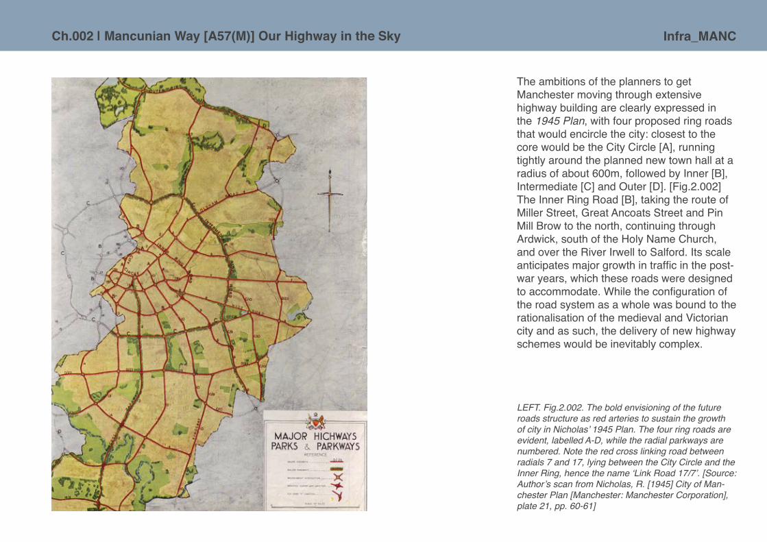
Infra_MANCCh.002 | Mancunian Way [A57(M)] Our Highway in the Sky
LEFT. Fig.2.002. The bold envisioning of the future roads structure as red arteries to sustain the growth of city in Nicholas’ 1945 Plan. The four ring roads are evident, labelled A-D, while the radial parkways are numbered. Note the red cross linking road between radials 7 and 17, lying between the City Circle and the Inner Ring, hence the name ‘Link Road 17/7’. [Source: Author’s scan from Nicholas, R. [1945] City of Man-chester Plan [Manchester: Manchester Corporation], plate 21, pp. 60-61]
The ambitions of the planners to get Manchester moving through extensive highway building are clearly expressed in the 1945 Plan, with four proposed ring roads that would encircle the city: closest to the core would be the City Circle [A], running tightly around the planned new town hall at a radius of about 600m, followed by Inner [B], Intermediate [C] and Outer [D]. [Fig.2.002] The Inner Ring Road [B], taking the route of Miller Street, Great Ancoats Street and Pin Mill Brow to the north, continuing through Ardwick, south of the Holy Name Church, and over the River Irwell to Salford. Its scale anticipates major growth in traffic in the post-war years, which these roads were designed to accommodate. While the configuration of the road system as a whole was bound to the rationalisation of the medieval and Victorian city and as such, the delivery of new highway schemes would be inevitably complex.

Infra_MANC Ch.002 | Mancunian Way [A57(M)] Our Highway in the Sky
The Mancunian Way, though a large infrastructural element in its own right, is not directly in line with these ring roads in the 1945 City of Manchester Plan, and was conceived as merely providing a direct connector between two radial spokes running out from the city centre. Much later on it would become part of quite a different ring road – the snappily titled ‘Manchester and Salford Inner Relief Route’ – which was cobbled together piece-meal using portions of existing roads and connecting them with purpose-built dual carriageway sections around the city centre. The final portion of this ring road, north of the Irwell, was eventually completed in 2004, nearly sixty years after the publication of the key post-war plan! [Fig.2.003] As such, approaching 70 years on, the city has a patchwork legacy of the 1945 ambitions; the ring road [as completed] is a hybrid of the proposed City Circle and Inner routes, portions of the intermediate exist to the south-east of the city [Alan Turing Way] and the Outer, never fully illustrated in 1945 Plan, but covered in the accompanying volume Manchester and District Regional Plan 19456 [Fig.2.004], is manifest as the M60 motorway. ABOVE. Fig.2.003. A small plaque ‘celebrating’ the completion of the Inner Relief Road. Link Road 17/7 is
incorporated as the lower third of the ovoid shaped ring. [Source: Plaque is located on Trinity Way in Salford. Photograph courtesy of Flicr user ‘Gene Hunt’ <www.flickr.com/photos/raver_mikey/515915184/>]
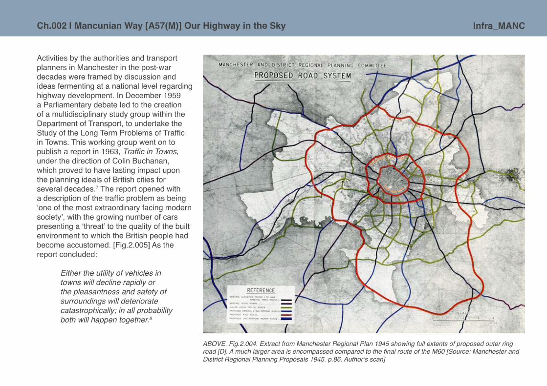
Infra_MANCCh.002 | Mancunian Way [A57(M)] Our Highway in the Sky
Activities by the authorities and transport planners in Manchester in the post-war decades were framed by discussion and ideas fermenting at a national level regarding highway development. In December 1959 a Parliamentary debate led to the creation of a multidisciplinary study group within the Department of Transport, to undertake the Study of the Long Term Problems of Traffic in Towns. This working group went on to publish a report in 1963, Traffic in Towns, under the direction of Colin Buchanan, which proved to have lasting impact upon the planning ideals of British cities for several decades.7 The report opened with a description of the traffic problem as being ‘one of the most extraordinary facing modern society’, with the growing number of cars presenting a ‘threat’ to the quality of the built environment to which the British people had become accustomed. [Fig.2.005] As the report concluded:
Either the utility of vehicles in towns will decline rapidly or the pleasantness and safety of surroundings will deteriorate catastrophically; in all probability both will happen together.8
ABOVE. Fig.2.004. Extract from Manchester Regional Plan 1945 showing full extents of proposed outer ring road [D]. A much larger area is encompassed compared to the final route of the M60 [Source: Manchester and District Regional Planning Proposals 1945. p.86. Author’s scan]
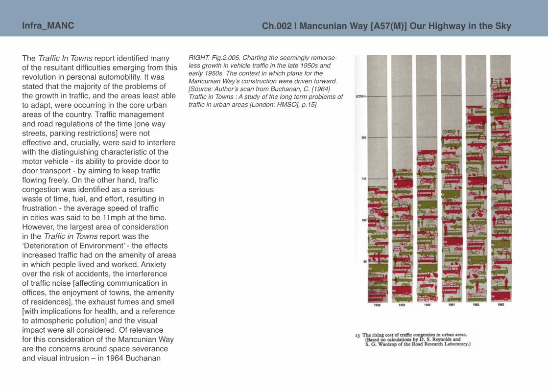
Infra_MANC Ch.002 | Mancunian Way [A57(M)] Our Highway in the Sky
The Traffic In Towns report identified many of the resultant difficulties emerging from this revolution in personal automobility. It was stated that the majority of the problems of the growth in traffic, and the areas least able to adapt, were occurring in the core urban areas of the country. Traffic management and road regulations of the time [one way streets, parking restrictions] were not effective and, crucially, were said to interfere with the distinguishing characteristic of the motor vehicle - its ability to provide door to door transport - by aiming to keep traffic flowing freely. On the other hand, traffic congestion was identified as a serious waste of time, fuel, and effort, resulting in frustration - the average speed of traffic in cities was said to be 11mph at the time. However, the largest area of consideration in the Traffic in Towns report was the ‘Deterioration of Environment’ - the effects increased traffic had on the amenity of areas in which people lived and worked. Anxiety over the risk of accidents, the interference of traffic noise [affecting communication in offices, the enjoyment of towns, the amenity of residences], the exhaust fumes and smell [with implications for health, and a reference to atmospheric pollution] and the visual impact were all considered. Of relevance for this consideration of the Mancunian Way are the concerns around space severance and visual intrusion – in 1964 Buchanan
RIGHT. Fig.2.005. Charting the seemingly remorse-less growth in vehicle traffic in the late 1950s and early 1950s. The context in which plans for the Mancunian Way’s construction were driven forward. [Source: Author’s scan from Buchanan, C. [1964] Traffic in Towns : A study of the long term problems of traffic in urban areas [London: HMSO], p.15]
Infra_MANCCh.002 | Mancunian Way [A57(M)] Our Highway in the Sky
questioned whether we should have accepted the visual intrusion of the motor vehicle as part of modern life, whilst suggesting that in the U.S., such acceptance was creating an undesirable aesthetic quality to their urban landscape. He also acknowledged the subjective nature of such questions - whether one welcomes or abhors the form of a new motorway is partly a matter of taste and vested interests.
The autopoietic nature of roads and the automobile set up an economy of ‘increasing returns’ for car manufacturers and associated industries, where the ‘steel-and-petroleum’ car has come to dominate and caused ‘automobility’ as we currently know it to be ‘locked-in’ to society. As sociologist of mobility John Urry9 suggests that at the same time as being economically locked-in, we are also seemingly socially locked-in to the patterns of mobility that the car affords us.
It is important to note that the increases in traffic, so feared in Traffic In Towns, were not the result of some major modal shift from public transport to cars, with the majority of car journeys resulting from the new possibilities and flexibility of the motor vehicle and would never have been made by public transport. Urry [2007] describes the car as being ‘immensely flexible and wholly coercive’.10 This echoes the aforementioned autopoiesis; not only are the structures and components of ‘automobility’ self replicating, but the use of the system encourages further use [even Buchanan acknowledged that building new urban roads would attract traffic flow].The ‘scientific’ logic of 1960s planning was to organize cities by zoning and to continue the slum clearances of the 1930s, that had been interrupted by war. The Town and Country Planning Act [1947], and its revisions, gave local authorities the powers to create new Comprehensive Development Areas [CDAs] and to make compulsory purchases of property within these allocated zones. Traffic in Towns had highlighted how urban traffic was directly related to the distribution of buildings and areas, with certain functions, and their interrelationship. Whilst occasionally typologically clustered, buildings of the same form were not typically within planned functional zones. Thus the programme of rebuilding, through clearance and rationalisation, seemed to offer opportunities for urban motorways in towns and cities across Britain. While the clearance areas determined the precise alignment of many urban motorway proposals, traffic surveys would often inform the size and capacity of such schemes.

Infra_MANC Ch.002 | Mancunian Way [A57(M)] Our Highway in the Sky
A strategic vision for roads: SELNEC starts plotting
Manchester Corporation’s notional routing of the Inner Ring, in its 1945 incarnation, can be seen to ‘define[..] the limits of the commercial area of the city’,11 excepting the exclusion of the university, the newly proposed cultural centre and some residential areas. This acknowledgement of the potential separation between the city centre and the areas to the south, points to a deliberate move to segregate the city into distinct zones, using infrastructure as a boundary. The power of separation is overtly expressed in the aesthetic language of the zoning plan, which shows a skeletal white line cutting right through the grey tissue of underlying urban fabric and sinews of existing streets. [Fig.2.006,]
RIGHT. Fig.2.006. The land-use zoning advanced in the 1945 Plan with its new and expansive white, wide and clear dual carriageways, with their equidistantly positioned, roundabouts effectively subdividing space in blocks of an activity. The broad denotation of Link Road 17/7 sweeping around the southern half of the city centre seems to connote an impenetrable barrier between residential hinterland and the commercial core. [Source: Author’s scan from Nicholas, R. [1945] City of Manchester Plan [Manchester: Manchester Corporation], plate 77, p.192-93]

Infra_MANCCh.002 | Mancunian Way [A57(M)] Our Highway in the Sky
Following the 1945 City of Manchester Plan, little happened in the city for well over a decade [in terms of concrete constructions and new infrastructure], this was largely due to the depth of post-war austerity.12 The next significant statement of purpose came in 1962 with publication of the SELNEC A Highway Plan. [Fig. 2.007] This was a comprehensive plan, drawn up by the South East Lancashire and North East Cheshire Highway Engineering Committee for the road network of Manchester and its surrounding conurbation.13 The study and the resulting proposals emerged from meetings between the Town Clerks, Surveyors and Highway Authorities of the SELNEC boroughs and the Divisional Road Engineer of the Ministry of Transport for the Northwest region. It was identified that the individual transportation plans of the constituent authorities were generally inadequate, as the ultimate traffic estimates on which they were based had, in many cases, been exceeded before the plans were formally published, let alone construction having started.
The issues identified in A Highway Plan broadly echoed those discussed at a national level. These included the problem of through-traffic – crossing the conurbation was described as ‘an exhausting experience’,14 - a lack of bypass routes for bulk traffic, incomplete ring roads with least number of junctions to facilitate free-flowing movement, the rapidly increasing volume of commuter car traffic [driven in part by affluence and the changing economic profile of Manchester] and the overall context of an inherited road system with inadequate capacity and layout. Manchester’s roads were mostly laid down during the rapid urbanisation of the Industrial Revolution, although some key thoroughfares do date from the eighteenth century ‘turnpike’ system15 and even earlier Roman and Medieval patterns of settlement and movement.16 In some respects the highway legacy parallels that of the railways and SELNEC also planned for major changes in the rail system for city in the 1960s and 1970s [see Chapter Three]. ABOVE. Fig.2.007. An atypically dramatic cover
design for a transportation report, hinting perhaps of the radicalism in air and the expectations for major changes sought. A Highway Plan: 1962 is a substantial tome, running to 95 pages and containing a depth of technical analysis which is supported by myriad of maps, charts and diagrams. [Source: Author’s photograph from SELNEC [1962] A Highway Plan 1962 [Manchester: South-east Lancashire and North-east Cheshire Area Highway Engineering Committee]]
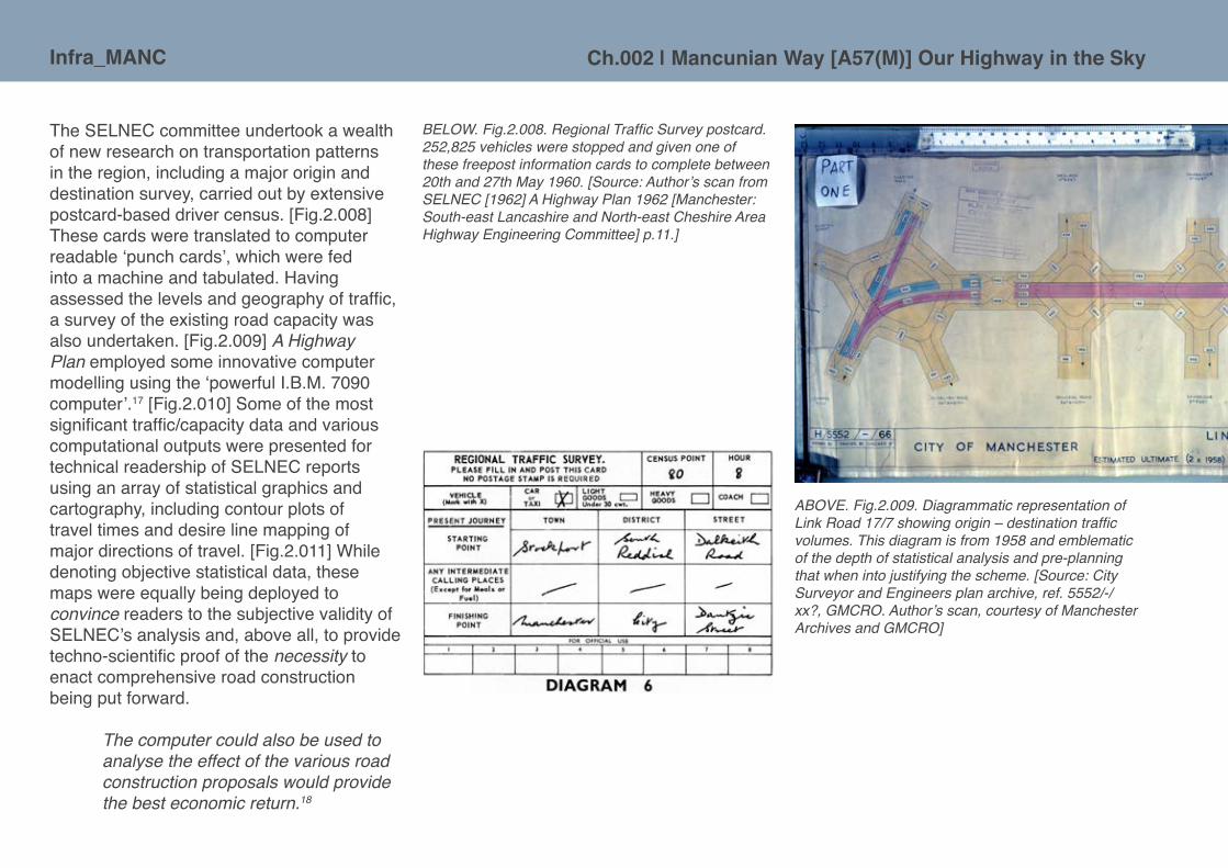
Infra_MANC Ch.002 | Mancunian Way [A57(M)] Our Highway in the Sky
The SELNEC committee undertook a wealth of new research on transportation patterns in the region, including a major origin and destination survey, carried out by extensive postcard-based driver census. [Fig.2.008] These cards were translated to computer readable ‘punch cards’, which were fed into a machine and tabulated. Having assessed the levels and geography of traffic, a survey of the existing road capacity was also undertaken. [Fig.2.009] A Highway Plan employed some innovative computer modelling using the ‘powerful I.B.M. 7090 computer’.17 [Fig.2.010] Some of the most significant traffic/capacity data and various computational outputs were presented for technical readership of SELNEC reports using an array of statistical graphics and cartography, including contour plots of travel times and desire line mapping of major directions of travel. [Fig.2.011] While denoting objective statistical data, these maps were equally being deployed to convince readers to the subjective validity of SELNEC’s analysis and, above all, to provide techno-scientific proof of the necessity to enact comprehensive road construction being put forward.
The computer could also be used to analyse the effect of the various road construction proposals would provide the best economic return.18
ABOVE. Fig.2.009. Diagrammatic representation of Link Road 17/7 showing origin – destination traffic volumes. This diagram is from 1958 and emblematic of the depth of statistical analysis and pre-planning that when into justifying the scheme. [Source: City Surveyor and Engineers plan archive, ref. 5552/-/xx?, GMCRO. Author’s scan, courtesy of Manchester Archives and GMCRO]
BELOW. Fig.2.008. Regional Traffic Survey postcard. 252,825 vehicles were stopped and given one of these freepost information cards to complete between 20th and 27th May 1960. [Source: Author’s scan from SELNEC [1962] A Highway Plan 1962 [Manchester: South-east Lancashire and North-east Cheshire Area Highway Engineering Committee] p.11.]

Infra_MANCCh.002 | Mancunian Way [A57(M)] Our Highway in the Sky
RIGHT. Fig.2.010. Diagrammatic map of the sample points used in the computer modelling work undertaken by the SELNEC researchers seeking to understand the road infrastructure of the region and the impacts of their planned improvements, including Link Road 17/7. [Source: Author’s scan from SELNEC [1962] A Highway Plan 1962 [Manchester: South-east Lancashire and North-east Cheshire Area Highway Engineering Committee], p.72]

Infra_MANC Ch.002 | Mancunian Way [A57(M)] Our Highway in the Sky
ABOVE. Fig.2.011. Illustrations of a desire map detailing the directions of major traffic flows and a contour plot of journey time. [Source: Author’s scans from SELNEC [1962] A Highway Plan 1962 [Manchester: South-east Lancashire and North-east Cheshire Area Highway Engineering Committee], p.8, 21]
Perhaps the key statistical mapping of the modelled reality of Manchester’s traffic problem presented in the 1962 A Highway Plan was the ‘overloading diagram’. It displays levels of traffic predicted for 1965 from the computer modelling. [Fig.2.012] The result of this was to demonstrate that 77% of the roads in the SELNEC study area would have been overloaded, with almost all major routes in Manchester city centre being overloaded by more than 150% of their capacity. The radial routes are all ‘predicted’ to be at, or over, capacity and converging on the central area, thus strengthening the argument for the provision of a lateral distributor road. The 1962 report makes it clear from these analyses that additional roads and further improvements were needed, over and above those included in the individual authorities’ existing Development Plan highway proposals. In a broad brush a swath of new roads and the re-engineering of existing roads are plotted on a large foldout map, entitled ‘The Highway Plan’. [Fig.2.013] In the central area, one of these new roads was to be Link Road 17/7, the Mancunian Way.
ABOVE. Fig.2.012. Overload on existing roads, perhaps the key envisioning of the transport analysis. Much of the highway resource of the SELNEC is red, warning level of overwork! [Source: Author’s scan from SELNEC [1962] A Highway Plan 1962 [Manchester: South-east Lancashire and North-east Cheshire Area Highway Engineering Committee], p.24]

Infra_MANCCh.002 | Mancunian Way [A57(M)] Our Highway in the Sky
ABOVE + LEFT. Fig.2.013. Extracts from ‘The Highway Plan’.This simple and compelling visual summation of all the necessary schemes being advocated in A Highway Plan, 1962 report.. [Source: Author’s scan from SELNEC [1962] A Highway Plan 1962 [Manchester: South-east Lancashire and North-east Cheshire Area Highway Engineering Committee], folded map as insert at rear of report.]

Infra_MANC Ch.002 | Mancunian Way [A57(M)] Our Highway in the Sky
Route planning and design conceptualisation of Link Road 17/7
It enables traffic to move sideways on to the radial giving the shortest access to its destination and thereby reduce cross movements within the City centre .... The decision to construct an elevated structure was conditioned largely by the number of junctions required for a comparable ground level road in crossing the smaller and less important roads in this area, and which would have presented a very severe restriction on the capacity of this link road.19
The Mancunian Way offers scope to examine conflicts and controversies in delivering large scale infrastructure into the urban scene, and the trade-offs between private driving and the wider public good. A relatively short section of elevated urban motorway, now forming part of Manchester’s inner ring road, it was planned in the 1950s and built between 1963 and 1967 to enable the free movement of goods and people around the city centre, a bypass to speed traffic from the Salford docks and Trafford Park across to the then significant industrial areas and railway goods yards of East Manchester, and then out and onwards to the South Yorkshire conurbation. The main purpose of the Mancunian Way was to act as a distributor for traffic from the main radial routes heading into the city centre from the south [which it still undertakes today]. Despite its elevated position, its construction required the clearance of sizeable surface area of the inner city, the compulsory seizing and demolition of homes and workplaces of many citizens. To bring Manchester’s highway in the sky into being it was also necessary to divert a river, stop-up many existing roads and widen other carriageways and junctions. Link Road 17/7 as a major piece of infrastructure undoubtedly fragmented communities.20 The nature of the elevated section of the Mancunian Way, in particular, meant there was potential for the road to form a visual blockade and physical boundary, perhaps even more so than a surface level road does. While infrastructure breaks apart existing places and also imposes a new identity on the landscape, it also creates its own spaces and social relations that need to be properly acknowledged. The elevation of the road brought into being a new type of space beneath [which this text will later examine in detail].
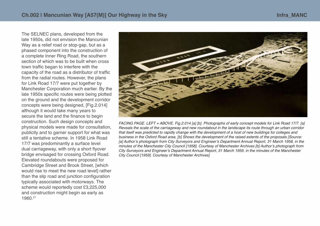
Infra_MANCCh.002 | Mancunian Way [A57(M)] Our Highway in the Sky
The SELNEC plans, developed from the late 1950s, did not envision the Mancunian Way as a relief road or stop-gap, but as a phased component into the construction of a complete Inner Ring Road, the southern section of which was to be built when cross town traffic began to interfere with the capacity of the road as a distributor of traffic from the radial routes. However, the plans for Link Road 17/7 were put together by Manchester Corporation much earlier. By the late 1950s specific routes were being plotted on the ground and the development corridor concepts were being designed, [Fig.2.014] although it would take many years to secure the land and the finance to begin construction. Such design concepts and physical models were made for consultation, publicity and to garner support for what was still a tentative scheme. In 1958 Link Road 17/7 was predominantly a surface level dual carriageway, with only a short flyover bridge envisaged for crossing Oxford Road. Elevated roundabouts were proposed for Cambridge Street and Brook Street, [which would rise to meet the new road level] rather than the slip road and junction configuration typically associated with motorways. The scheme would reportedly cost £3,225,000 and construction might begin as early as 1960.21
FACING PAGE. LEFT + ABOVE. Fig.2.014 [a] [b]. Photographs of early concept models for Link Road 17/7. [a] Reveals the scale of the carriageway and new roundabout in the landscape its route through an urban corridor that itself was predicted to rapidly change with the development of a host of new buildings for colleges and business in the Oxford Road area. [b] Shows the development of the raised extents of the proposals [Source: [a] Author’s photograph from City Surveyors and Engineer’s Department Annual Report, 31 March 1958, in the minutes of the Manchester City Council [1958]. Courtesy of Manchester Archives [b] Author’s photograph from City Surveyors and Engineer’s Department Annual Report, 31 March 1959, in the minutes of the Manchester City Council [1959]. Courtesy of Manchester Archives]

Infra_MANC Ch.002 | Mancunian Way [A57(M)] Our Highway in the Sky
The archives seem to have little detail on the disruptive process of assembling of land and properties that were in the way of the new highway in the sky. In the documentary film [discussed below] celebrating the construction and opening of the Mancunian Way, perhaps expectedly, given that it is aimed at engineers and concrete enthusiasts, the whole subject of the social impact of the clearance of the area through which the road passes is cursorily mentioned: ‘cutting across what used to be a slum quarter and was anyway scheduled for demolition’.22 Work on clearing a route for the Mancunian Way or Link Road 17/7, as it was initially known, had been part of the legal landscape at least since 1948, when the first compulsory purchase orders were made for an area around Knott Mill. [An area of significant bomb damage in the Second World War.] At an enquiry C.A. Marsh, Deputy Town Clerk, made representation that the ‘cheek by jowl’ pattern of existing building in the area was ‘mean and insignificant’ and that the major highway proposals were in fact ‘the very framework of the Manchester Plan.’23 It was acknowledged in the hearing that the
BELOW. Fig.2.015. Plan of the land required to build Link Road 17/17. The hand annotation notes that it was submitted to the Town Planning and Buildings Committee on 13th August 1957 and was ‘approved’. [Source: City Surveyor and Engineers plan archive, ref. 5552/-/16, GMCRO. Author’s scan, courtesy of Manchester Archives and GMCRO]

Infra_MANCCh.002 | Mancunian Way [A57(M)] Our Highway in the Sky
properties would not be required until 1958, by which time a further 900 properties in central Manchester were also subject to compulsory purchase.24 [Fig.2.015] Some nearby areas had been previously obliterated as part of the slum clearance programme in Hulme before the Second World War, and happened to be part of the planned route of Link Road 17/7. At the time of these first compulsory purchases, the cost of the work was estimated at £1.6 million, plus another £1.4 million for the necessary acquisitions.25 In 1959 the first 26 houses were demolished for the River Medlock culvert, facilitating the first phase of the scheme, a ground level dual carriageway running from Pin Mill Brow in the east, to Downing Street/London Road in the west.
In 1959, it was announced that the previous ground level scheme was to be replaced by an elevated section, and in 1962 the new scheme was approved by the city council.26 This saw the start of large scale clearance work for the new road. [Fig.2.016] The Manchester Evening News reported the start of major demolition with some detail: ‘Irishman Desmond Farrell of Bluestone Road, Moston, set his giant 140hp bulldozer rolling at 10am today on a site at Union Street, Ardwick, to start work on the city’s £9m 17/7 highway’.27
ABOVE + ABOVE RIGHT. Fig.2.016. Demolition of building along the route of Link Road 17/7. Major hydraulic engineering with the culverting of the River Medlock. [Sources: Mancunian Way 1967 Screen grab: Demolition, North West Film Archive & Concrete Society. Medlock Culvert Construction, Milligan, H.1962 London Road, M60788. Manchester Libraries Local Image Collection. Manchester Central Library, Local Studies Unit]

Infra_MANC Ch.002 | Mancunian Way [A57(M)] Our Highway in the Sky
Inserting new infrastructure into an urban situation will inevitably have consequences on existing services and utilities. The City Engineer and Surveyors Department had to manage the mundane, but vital, utilities of drainage and sewers and also liaise with other providers of gas, electricity and telecommunications that would be impacted by the construction of Link Road 17/7. [Fig.2.017] Many of the utilities that service cities are hidden within the landscape and are not noticed, but the new highway route had a significant and visible effect on the existing road structure that it swept through. There were some 32 roads that had to be stopped-up completely and numerous others were reconfigured for the insertion of this infrastructural monolith in the landscape. [Fig.2.018] It can be argued that through the loss of these streets, the Mancunian Way has formed a physical barrier to movement in multiple directions, by reducing the number of potential routes in and out of the city from the established neighbourhoods of Hulme and Brunswick. The adequacy of pedestrian routes crossing the road would, therefore, be of major consequence to residents of these areas.
ABOVE. Fig.2.017. Detailing the diversion of utility services caused around the Brook Street junction of the Mancunian Way. [Source: City Surveyor and Engineers plan archive, ref. 5552/-/456, GMCRO. Author’s scan, courtesy of Manchester Archives and GMCRO]

Infra_MANCCh.002 | Mancunian Way [A57(M)] Our Highway in the Sky
ABOVE. Fig.2.018. Streets erased along the route of the Mancunian Way. [Source: Thorp, J.K. [2010] Highway in the Sky: A socio-technical analysis of the urban motorway [Unpublished Dissertation, Manchester School of Architecture], p.39. Courtesy of James Thorp]

Infra_MANC Ch.002 | Mancunian Way [A57(M)] Our Highway in the Sky
The final design for the elevated road itself emerged from a competition, organised by the Prestressed Concrete Development Group. G. Maunsell & Partners28 were responsible for the winning entry, beating 24 other schemes, and were appointed consulting engineers, working alongside the Manchester City’s Engineers and Surveyors Department.29 The design preparation, prior to construction, involved some scientific testing of scaled structural models by the research station of the Cement and Concrete Association. [Fig.2.019] The 1/12th scale micro-concrete models were used to assess the level of prestressing within the cantilever of the units, strain distribution, working loads, torsional properties, the effect of point loads, and the ultimate strength of the entire structure.30
The road was considered of such significance in terms of its technology and structure that the Cement and Concrete Association professionally produced a thirty minute film documenting its construction, with suitably 1950s newsreel style narration.31 The film begins the narrative by proclaiming the Mancunian Way as being ‘in a direct line of descent of the Hammersmith Flyover’. [Fig.2.020] [The Hammersmith Flyover was the first road to be constructed using precast segments, jointed with in-situ concrete, and later stressed together to form a continuous structure.] The acts and records committed to celluloid could not be anything other than of their time; there is a palpable sense of pride in the pioneering engineering achievements being undertaken and, despite the urgency in the delivery of the scheme, an attitude that the research and development is paramount to the success of the road for the city, the wider region and even for the nation. Despite this apparent supercilious tone, the working practices seen on film leave little to be desired when compared to today’s risk averse and safety conscious construction industry. Bare-chested contractors are seen pouring concrete without gloves and with no regard for the residual splashes filling up their rubber boots. Wielding proceeds matter-of-factly without much protective clothing. There isn’t a harness or ManSafe device in sight as the high level shuttering and reinforcement bars are put into place, the arms of excavators swing perilously past workers’ unprotected heads and the half-burnt cigarette, drooping from the mouth, appears to be, in the mid 1960s, a compulsory on site condition! [Fig.2.021]
ABOVE. Fig.2.019. Model testing. [Source: Somerville, G. [1965: 60] ‘Tests on a one-twelfth scalemodel of the Mancunian Way’, in Journal of Strain Analysis, 1[1]: 57-68]

Infra_MANCCh.002 | Mancunian Way [A57(M)] Our Highway in the Sky
FACING PAGE + LEFT. Fig.2.021. A range of images of various working practices in construction of the 1960s. [Source: Mancunian Way, 1967. Author’s screen grab. Courtesy North West Film Archive & Concrete Society]
RIGHT. Fig.2.020. [a] Hammersmith Flyover,exploded view of superstructure [Source: Rawlinson, J. & Stott, P.F. 1962. The Hammersmith Flyover. Proceedings of the Institute of Civil Engineers, 10, 565-600.] [b] Mancunian Way, exploded view of superstructure [Source: G. Maunsell & Partners [1963] Link Road 17/7 Report on Elevated Structure, drawing no. 8. Private Collection] Mancunian Way, as a descendent of Hammersmith shares characteristics in it construction, including the jointing and pre-stressing techniques.
[a] Hammersmith Flyover [b] Mancunian Way

Infra_MANC Ch.002 | Mancunian Way [A57(M)] Our Highway in the Sky
RIGHT. Fig.2.022. Offramp to nowhere. [Source: Author’s photograph]
The technical details of the construction can be read over the following pages, but one enduring oddity is the ‘exit ramp to nowhere’ behind the former BBC headquarters and adjacent to Upper Brook Street. [Fig.2.022] This was supposed to form the junction between Mancunian Way and a new radial route dual carriageway that was scheduled to extend along the length of Princess Street and to join a two level road of the same gauge planned for the length of Portland Street! This was the legacy of the 1945 City of Manchester Plan in action for even though as published it was not a statutory document and a formal submission of a Development Plan was made to central government in 1951, and was not ratified until 1961, by which point the obsolescence of central planning was evident and the caveat that came with Whitehall approval was to revisit the central area design.32 Newly appointed Chief Planner for city, J.S. Millar, and his team, worked tirelessly through the mid-1960s to produce frameworks for the designated CDAs and to revise and incorporate the existing city centre road proposals. The result was an even more ominous and constrictive ring around the centre, at some points a multi-level dual carriageway [Figs.2.023], while the entire city was physically modelled and on display to the public.33

Infra_MANCCh.002 | Mancunian Way [A57(M)] Our Highway in the Sky
LEFT + BELOW LEFT. Fig.2.023. Images of model used as public consultation device in the 1960s. The model shows the full extents of the city centre road in its 1967 aligment [Source: Hayes, J., City Engineer [1968] Manchester City Centre Road [Manchester: City of Manchester Corporation]]
[b] Area north of River Irwell and the former Exchange railway station.
[a] View of city from west, Central Station in foregorund.
[c] View of Piccadilly Gardens and the new Piccadilly Plaza in the mid-ground with multi-level carriageways forming canyon like space to Portland Street.

Infra_MANC Ch.002 | Mancunian Way [A57(M)] Our Highway in the Sky
The extents [Fig.2.024] seem incredible to conceive of now and those cities that are truly ‘carved’ by their post-war urban motorways continue to fight to overcome the physical and psychological severance of space with public realm design schemes that seem destined to failure as the atmosphere carries such negative perceptions.
It was at a public enquiry into a twenty-seven storey office block proposed for 103 Princess Street [Fig.2.025] that a decisive nail was hammered into the coffin of Manchester’s city centre motorway ambition.34 The highway scheme would have required the demolition of several sizable and architecturally significant Victorian warehouses along Princess Street and Portland Street. Without the aid of a barrister, a team of local experts and architectural enthusiasts, including John Archer and Donald Buttress, took on and defeated Castle Irwell Properties, and its assembled professional consultants, over the course of the three day hearing in defence of the buildings. The Chair of the Public Enquiry praised the historic research that had been prepared.35 The proposal for the new tower did not sit directly on the site of threatened buildings, York House and the Mechanic’s Institute, but would have required the demolition of both for its setting and, ultimately, the dual carriageway section of the new radial motorway. It was really the
ABOVE. Fig.2.024. City Centre Road as proposed in 1968. [Source: Hayes, J., City Engineer [1968] Manchester City Centre Road [Manchester: City of Manchester Corporation]]
ABOVE. Fig.2.025. Portland Towers, proposed development by Leach Rhodes Walker on behalf of Castle Irwell Properties Ltd. [Source: Leach Rhodes and Walker. Architects and Town Planning Consultants, Leach Rhodes and Walker. Private collection]

Infra_MANCCh.002 | Mancunian Way [A57(M)] Our Highway in the Sky
first debate of its kind concerning the wider value of Victorian and Edwardian buildings in Manchester and was to set the precedent and change the landscape, metaphorically and physically, in terms of the appreciation of historic buildings and the realisation of the massive city centre ring road. In the immediate aftermath of the enquiry, this meant enforced compromises to the Portland Street element of the ring road, which was a major component feeding Piccadilly and linking the centre with the major commuter radial routes out to exurban Cheshire. The difficulties of land assembly and the massive hike in the price of petrol following the 1973 oil crisis also contributed to the demise of the ambitious ‘highways in the sky’ notion and in 1976 the Greater Manchester Council abandoned the proposals entirely.36 This was not before the press had criticised the policies which created multiple sites that had been left vacant for years with the anticipation of pending development and were seen as a very visible blight on the city. The plans were considered over ambitious and referred to as an ‘optimists delight’ and ‘library of schemes to be tackled when finances allow’.37
ABOVE. Fig.2.026. General arrangement of the junction between Mancunian Way and Brook Street, as built. The ‘offramp to nowhere’ can be seen as a spur, the tip of which is shaded in yellow. The realignment of Brook Street never arrived and the junction configuration remains largely as seen here. [Source: City Surveyor and Engineers plan archive, ref. 5552/142/254, GMCRO. Author’s scan, courtesy of Manchester Archives and GMCRO]
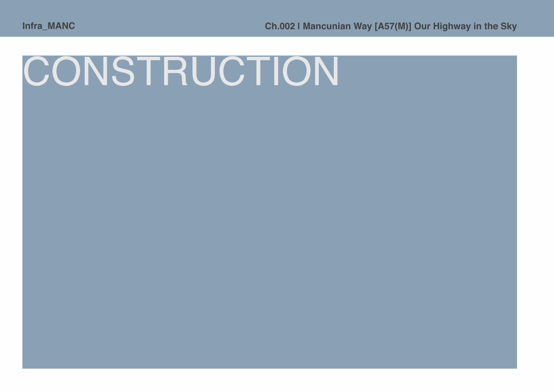
Infra_MANC Ch.002 | Mancunian Way [A57(M)] Our Highway in the Sky
CONSTRUCTION

Infra_MANCCh.002 | Mancunian Way [A57(M)] Our Highway in the Sky
Link Road 17/7 as constructed initially was 3km long and the elevated section extended for nearly 1.2km and is made up of 32 spans, nearly all of which are 32m long. There are six major roundabout junctions and including the two end approaches, there are eight ramps. The western part of the road consists of dual two-lane precast sections and the eastern part of dual three-lane precast sections, which are joined by a central transitional structure, cast mainly in-situ. The size and weight of the elevated structures required significant foundations and piling. These were drilled to the bedrock, at depths between 9 - 23m, where tests indicated a bearing capacity of 350 tons in the western part, and 600 tons in the eastern. Cement-bentonite grout was injected into water bearing strata, a feature that was missed in the original site investigation and later discovered on site. One in four raked piles support the anchorages. Reinforcement cages were assembled on site, and lowered to the full depth, with concrete spacers, and then concrete poured continuously to form the pile. In-situ caps joined each pair of piles, built into which were starter reinforcement bars for the columns supporting the road deck.
It’s the most advanced road in the world. [Manchester Evening News, 20 April 1966]
Infra_MANC Ch.002 | Mancunian Way [A57(M)] Our Highway in the Sky
The elevated road deck
The 985 metres long elevated structure at the heart of the Mancunian Way was constructed mainly using precast concrete units, although an intermediate structure of in-situ concrete forms the central section [Fig. 2.027] and four access ramps to the elevated road. At the time of construction it was considered to be an innovative design, including several interesting features and design solutions.
The project was scheduled so that as columns were completed on site, the production of precast units off site was continuing at a similar pace. The need for uniformity of units for the economic running of the casting yard, though slight variations were required for the positioning of the tension cable ducts, the anchorages and some units were tapered for curved road sections. The density of reinforcement and ductwork required similar vibration methods to be employed in the yard as were performed on site for the columns. Once the units had been cast, the joining edges were hammered to provide mechanical adherence for the in-situ joints to bond with. With concern for the finished appearance, any exposed metalwork was hand-painted with grout to prevent the often seen rust-staining of the reinforced concrete. In the autopoietic manner of roadbuilding, the precast units were designed to dimensions that could be transported by an ordinary low-loader lorry, by road, to the site of the new road. [Fig.2.030]
ABOVE. Fig.2.027. Hand annotated drawing of elevated section with Pickfords removal van shown and query over required clearances. [Source: Uncatalogued contract drawings, GMCRO. Author’s photograph, courtesy of Manchester Archives and GMCRO.]

Infra_MANCCh.002 | Mancunian Way [A57(M)] Our Highway in the Sky
ABOVE. Fig.2.028. In-situ casting of columns [Source: Mancunian Way, 1967. Author’s screen grab. Courtesy North West Film Archive & Concrete Society]
ABOVE. Fig.2.029. Pre-casting of road sections at Len Fairclough’s casting yard in Adlington, near Chorley [Source: Mancunian Way, 1967. Author’s screen grab. Courtesy North West Film Archive & Concrete Society]
ABOVE. Fig.2.030. Pre-cast units transported to site by lorry [Source: Mancunian Way, 1967. Author’s screen grab. Courtesy North West Film Archive & Concrete Society]

Infra_MANC Ch.002 | Mancunian Way [A57(M)] Our Highway in the Sky
In-situ transition structures
A major element in the scheme was the construction of the transitional structure, which carries the Mancunian Way over Oxford Road, connects the two and three-lane sections, provides four access ramps, and is the structural anchorage for the entire structure. The multiple functions of this section meant that it has a non-standard width and form, preventing the economical use of precast units. The box spine beam was cast first, proceeded by the full width of the road deck. The formwork was mainly supported by tubular steel scaffolding [Fig.2.031], but where it crossed a road, steel girders were employed allowing traffic to continue to flow beneath. In an effort to promote continuity of appearance between the precast and in-situ elements, sand, cement and aggregates were supplied from the same sources to both casting sites. This continuity was extended to the exposed faces of the structure - ‘dummy’ joints were cast along its length, making it difficult to see where construction methods differ. The transition structure was cast in maximum lengths of 9.14m, with seven day pauses between concrete pours, to minimise the effects of shrinkage. The two anchorage ramps were constructed with precast columns and precast units, with the two anchor blocks beneath, and access to the stressing cable ducts between. The anchorage abutments are enclosed in a box structure, on top of the previously mentioned raked piles, and the end block of the ramp is tied to the anchorage block using macalloy bars, and supported on a bearing plinth within the box. Rubber bearings and steel spacers accommodate any movement at the anchorage. These anchorage structures were constructed before the precast units of the main carriageway were assembled, so that the precast sections could be stressed back to the anchorage points.
Key to the construction of the Mancunian Way are the structural anchorages, located centrally in the north and south abutments, beneath the ramps leading to the Cambridge Street roundabout [Fig.2.032], ‘cone- type’ expansion joints are installed at the other abutments. The bearings are small and unseen to the public, but vital to the structure. Where movement between components of the structure was anticipated, bearings were introduced to allow the structure to adjust without failure. The bearings used on the Mancunian Way are of the ‘pot’ type, which, when combined with a PTFE pad, allows for both rotational and sliding movement. [Fig.2.034] The pot bearing comprises a steel plate fixed to the column top, on which sits a rubber disc [which acts as a fluid when under pressure], and on top of that is another steel plate fixed to a circular collar. A disc of PTFE sits in a recess on top of the collared plate, and underneath a flat steel plate fixed to the deck unit. During assembly, the bearings were temporarily fixed to the underside of the precast units. These bearings allow for several centimeters of movement.
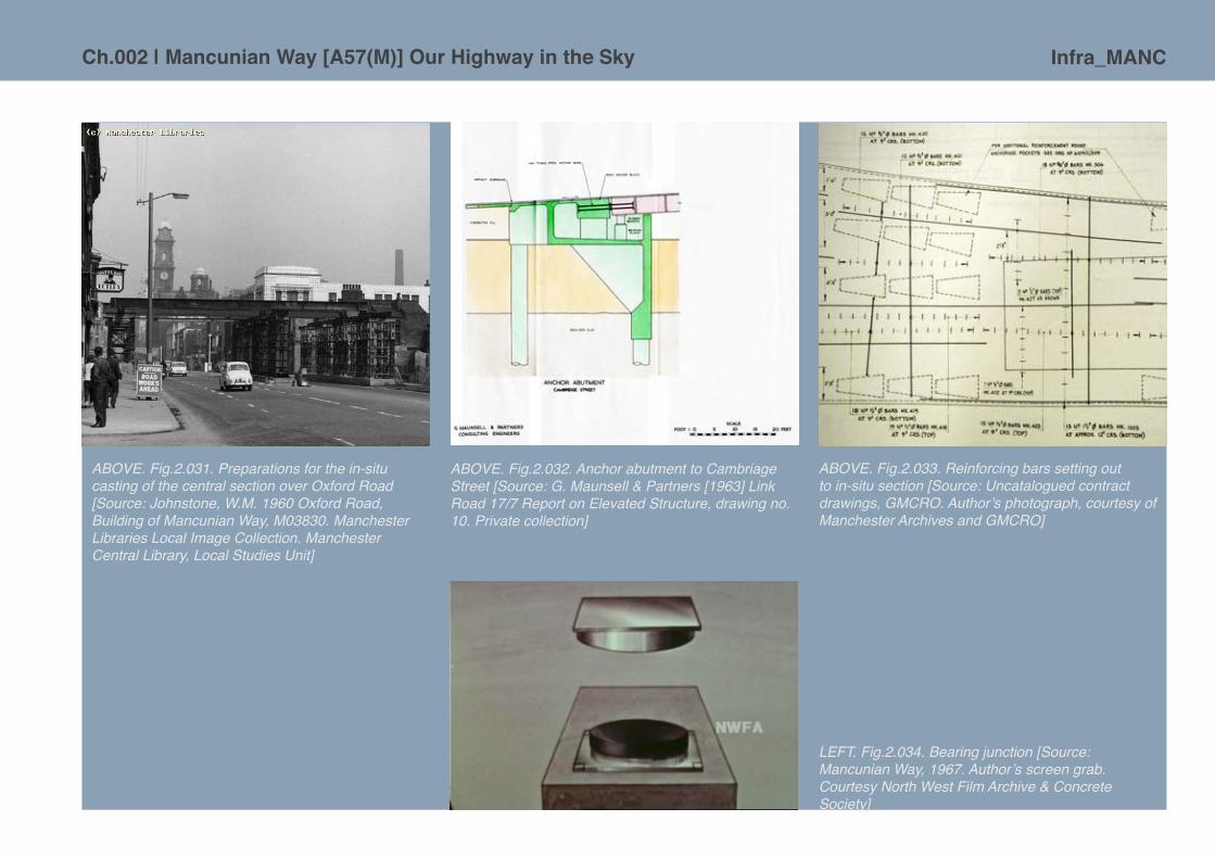
Infra_MANCCh.002 | Mancunian Way [A57(M)] Our Highway in the Sky
ABOVE. Fig.2.031. Preparations for the in-situ casting of the central section over Oxford Road [Source: Johnstone, W.M. 1960 Oxford Road, Building of Mancunian Way, M03830. Manchester Libraries Local Image Collection. Manchester Central Library, Local Studies Unit]
ABOVE. Fig.2.032. Anchor abutment to Cambriage Street [Source: G. Maunsell & Partners [1963] Link Road 17/7 Report on Elevated Structure, drawing no. 10. Private collection]
ABOVE. Fig.2.033. Reinforcing bars setting out to in-situ section [Source: Uncatalogued contract drawings, GMCRO. Author’s photograph, courtesy of Manchester Archives and GMCRO]
LEFT. Fig.2.034. Bearing junction [Source: Mancunian Way, 1967. Author’s screen grab. Courtesy North West Film Archive & Concrete Society]

Infra_MANC Ch.002 | Mancunian Way [A57(M)] Our Highway in the Sky
Putting it all together: Joints, pre-stressing and stressing to produce a monolithic structure
Jointing: The joints between precast units were cast in-situ. The recesses which help to reveal the componential nature of the Mancunian Way were formed by propping suitably sized plywood against the scaffolding beneath the units. Continuity of ducting was maintained by inserting inflatable rubber tubes through the sections to be joined - this needed to be timed well in order for the concrete not to either collapse or stick to the tubing. The continuity of the hollow spine was arranged by fitting plywood formwork internally. The process was required to accommodate the differing movements throughout construction, as the series of spans were completed and needed to be tied to the anchored structure:
1. The span on the left is stressed back to the rest of the structure, and is monolithic, moving with it. Each section is erected on falsework [scaffolding] with ball joints allowing longitudinal and rotational movement.
2. The next units are placed onto the falsework, which is initially diagonally braced to preventlongitudinal movement.
3. Before the final joints are made, the new span must move with the existing structure, and so a temporary join is made using adjustable ‘Macalloy’ steel bars on the deck. As the bars are tightened, the diagonal bracing is removed.
4. The span is now moving with the rest of the structure, so the final joints are cast. Thetemporary bars remain in place until the new span is stressed.
LEFT. Fig.2.035. Construction sequence [Source: Mancunian Way, 1967. Author’s screen grab. Courtesy North West Film Archive & Concrete Society]
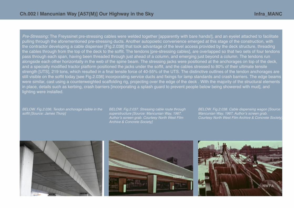
Infra_MANCCh.002 | Mancunian Way [A57(M)] Our Highway in the Sky
Pre-Stressing: The Freyssinet pre-stressing cables were welded together [apparently with bare hands!], and an eyelet attached to facilitate pulling through the aforementioned pre-stressing ducts. Another autopoietic convenience emerged at this stage of the construction, with the contractor developing a cable dispenser [Fig.2.038] that took advantage of the level access provided by the deck structure, threading the cables through from the top of the deck to the soffit. The tendons [pre-stressing cables], are overlapped so that two sets of four tendons pass through each span, having been threaded through just ahead of a column, and emerging just beyond a column. The tendons run alongside each other horizontally in the web of the spine beam. The stressing jacks were positioned at the anchorages on top of the deck, and a specially modified tractor platform positioned the jacks under the soffit, and the cables stressed to 80% of their ultimate tensile strength [UTS], 219 tons, which resulted in a final tensile force of 40-55% of the UTS. The distinctive outlines of the tendon anchorages are still visible on the soffit today [see Fig.2.036] incorporating service ducts and fixings for lamp standards and crash barriers. The edge beams were similar, cast using a counterweighted scaffolding rig, projecting over the edge of the deck . With the majority of the structural elements in place, details such as kerbing, crash barriers [incorporating a splash guard to prevent people below being showered with mud], and lighting were installed.
BELOW. Fig.2.036. Tendon anchorage visible in the soffit [Source: James Thorp]
BELOW. Fig.2.037. Stressing cable route through superstructure [Source: Mancunian Way, 1967. Author’s screen grab. Courtesy North West Film Archive & Concrete Society]
BELOW. Fig.2.038. Cable dispensing wagon [Source: Mancunian Way, 1967. Author’s screen grab. Courtesy North West Film Archive & Concrete Society]

Infra_MANC Ch.002 | Mancunian Way [A57(M)] Our Highway in the Sky
Opening and operation of Mancunian Way The two openings [legal and ceremonial] of the road exhibit a paradoxical situation, with a grand opening by the nation’s Prime Minister on 5th May 1967 being preceded, apparently, by a sixteen year old driver in a three-wheeled van worth thirty pounds, as the first public vehicle to traverse the new £5.5 million route.38
On the ground and in the air, Manchester, the bustling capital of the North, is set to meet the exciting challenge of the 1970s. Only days before the opening of the city’s £5m Mancunian Way, bulldozers have moved into fields to start extending the main runway at Manchester Airport.39
Other press stories reflect the more mundane reality of the new ‘highway in the sky’, with coverage of ‘embarrassment’ at the initial failure of the local authority to obtain the legal powers needed to enforce motorway restrictions,40 of a motorists’ ‘boycott’ of the new road with people used to their regular routes41 and later stories of the ‘menace’ of Mancunian Way traffic being funnelled into Salford causing tensions in the planning departments of the neighbouring cities.42
On the day of the official opening of the road, The Guardian ran an article written by the director of the Civic Trust for the North-West, Graham Ashworth.43 The article suggests larger opportunities were missed in the scheme’s overall conception: the potential of a true urban motorway integrated with buildings or the possibility of a fully landscaped parkway. This was partly a result of legislative and political difficulties with obtaining the greater area of land required for such schemes, and also that this scheme had been on the drawing board for many years [pre-Buchanan] before conception. Ashworth critiqued the so-called ‘mini-parks’ in the roundabouts, with forms of the hard landscaping described as ‘a little meaningless’ and compared to ‘crazy-paving’, and the landscaping he predicted would always appear rather thin. The pedestrian subways he said were ‘no more welcoming than any other underpasses in this country’. While the aesthetic opinion of the structure as a whole was positive - ‘extremely light and elegant in appearance’ -, it was the accompanying landscaping and the detailing of fixtures that lets it down. These elements are what determines in the local public’s eyes the ultimate success of the road in architectural rather than traffic-management terms, as a piece of urban design rather than merely functional infrastructure.
BELOW. Fig.2.039. Mancunian Way. Map from publicity pamphlet [Source: Private collection]

Infra_MANCCh.002 | Mancunian Way [A57(M)] Our Highway in the Sky
There is an evident sense of pride in achieving the construction of a large segment of infrastructure in terms of the promotional materials produced by Manchester Corporation to celebrate the opening of the Mancunian Way. For example, a two-side brochure with a simple but effective map and striking cover was produced [Figs.2.039 + 2.040], the sweeping curve of the aerial runway cuts through the composition and disappears over the viewers shoulder, the bold sans serif font embodies the power of the modern, whilst the city crest has an assuring civil intent. A more technical twenty-five page booklet was also produced, with an impressive architects rendering of the elevated highway in action on the cover [Fig.2.041] and a wealth of with engineering diagrams inside, setting out for the reader the design and construction of the road44. In 1968 the Mancunian Way won the Concrete Society award. A plaque marking the award is displayed prominently on the structure, near a footpath passed by hundreds of pedestrians a day who are forced under the award winning elevated highway structure itself. [Fig.2.042 + 2.043]
ABOVE. Fig.2.040 Mancunian Way. Cover of publicity pamphlet. [Source: Private collection]

Infra_MANC Ch.002 | Mancunian Way [A57(M)] Our Highway in the Sky
Putting aside promotional booklets and prizes from the Concrete Society, other bodies were more critical of the spatial success of the road scheme. For example, the Architect’s Journal commented in 1964 on how the SELNEC Highway Plan, of which the Mancunian Way formed a core part, did not define spaces that could be described as the ‘environmental areas’ recommended in Traffic in Towns.45 The article goes on to critique the Corporation inadequate plan to deal with the problem of traffic noise for residents in flats built alongside the road only ‘as it arose’.
The original elevation configuration of the road was also perceived as problematic once it had opened to traffic. The western end of Mancunian Way originally terminated as a roundabout junction with Chester Road, a ‘temporary’ flyover that would allow traffic into the city to continue unabated and over the junction was subsequently completed in 1969 at an additional cost of £250,000.46 It was not until 1992 that the sunken section beneath Chester Road was actually completed as had been proposed, up to that point the rapid ascent and descent of the rather too steeply inclined flyover was considered by many drivers to be a bit of urban roller-coaster!
ABOVE. Fig.2.041. Mancunian Way booklet jacket. [Source: CCA [1966] Mancunian Way: City of Manchester Link Road 17/7 Stage 2 [London: Cement & Concrete Association]]
ABOVE. Fig.2.042. Mancunian Way over Brook Street [Source: Author’s photograph]
ABOVE. Fig.2.043. Concrete Society Award 1968 plaque [Source: Author’s photograph]

Infra_MANCCh.002 | Mancunian Way [A57(M)] Our Highway in the Sky
The road is periodically closed for cleaning [a moment often embraced by adventurous cyclists and pedestrians] and very occasionally halted by protest47 or shut down for emergency inspections.48
The development of UMIST and the surrounding areas was conducted largely in parallel to the construction of the Mancunian Way, the culverting of the River Medlock freed up the land to the south of the MSJ&A railway viaduct and this allowed for the significant expansion of the campus. Land to the south of the Mancunian Way was also proposed for a student village and considered in tandem with the developing road proposals.49 [Fig.2.044] A range of new buildings, conceived in the 1960s, are now event nestling alongside the elevated roadway and seem to be resonate with a technological hum, the clean gleam of the futomodernist: notable are the National Computing Centre [Cruickshank & Seward, 1964] [Fig.2.045], the positively technocratic systems of developing concrete construction employed in the Ferranti Building [Cruickshank & Seward, 1968] and Faraday Building [H.S. Fairhurst & Sons, 1967]. Even the new brick buildings, most especially the BBC block on Oxford Road [R.A. Sparks, 1975, John Dalton, S.G. Besant-Roberts, City Architect, 1966-74] floated horizontal geometries that signified their modern
ABOVE. Fig.2.044. Early, and unbuilt, proposals for 2,000 room student village for UMIST by Cruickshank + Seward 1961 [Source: Courtesy of John Sheard]

Infra_MANC Ch.002 | Mancunian Way [A57(M)] Our Highway in the Sky
RIGHT. Fig.2.045. The National Computing Centre. [Source: Author’s photograph]
construction. The development of the city’s colleges and universities to form the Manchester Education Precinct have also led to the road being progressively enveloped over several decades by buildings on either side of its central elevated section, along with some sporting facilities in the spaces beneath the road. These buildings and their associated uses accentuate the feeling of the Mancunian Way being elemental to some kind of technological urban ‘upgrade’ in the 1960s, a positive surge of energy after the darker days of the Second World War and a decade or more of austerity. Views from the upper floors of these companion buildings, of traffic speeding by on a ‘highway in the sky’, allow the road to live up to its visionary title for a few moments through this dense cluster of elevated concrete and the mundanity of everyday mobility.
ABOVE. Fig.2.046. UMIST campus viewed from the south-east with surface level junction to London Road [Source: Ref UPC/2/395. Courtesy of the John Rylands University Library]

Infra_MANCCh.002 | Mancunian Way [A57(M)] Our Highway in the Sky
The space under the road above
[M]odernist urban landscapes were built to facilitate automobility and to discourage other forms of human movement... [Movement between] private worlds is through dead public spaces by car.50
The system of automobility has manifested itself physically in the introduction of motorways to Britain. A new infrastructural language of overpasses, underpasses, massive roundabouts, sweeping junctions, wide verges, islands and supposedly ‘placeless’ service stations has developed. Yet these spaces have acquired their own qualities, and despite being seemingly ‘dead’, hold their own ongoing narratives51. The use of the spaces beneath the Mancunian Way was considered, in various forms, in the early planning and design stages, and suggestions for additional uses have emerged since. The aesthetic quality and social success of these spaces below the streams of traffic thundering overhead plays a large part in the physical effect of the road and any potential severance.
A most visible aspect of the Mancunian Way is the sheer physical scale of the roundabout in the urban landscape. Interestingly from early on these newly manufactured spaces of the motorway were envisioned as ‘mini-parks’ [Fig.2.047], each the size of Albert Square [Manchester’s iconic public space in front of the Town Hall]. The design approach for this element was seen through to completion, however, with debatable success since. Original local authority suggestions of uses for these landscaped areas included ‘recreational purposes’ for students52 and as
BELOW. Fig.2.047. Brook Street intersection, landscaping details [Source: City Surveyor and Engineers plan archive, ref. 5552/162/533, GMCRO. Author’s scan, courtesy of Manchester Archives and GMCRO]

Infra_MANC Ch.002 | Mancunian Way [A57(M)] Our Highway in the Sky
forum areas for ‘public-speaking’.53 It is claimed that two thousand trees were to have been planted along the route of the road, twenty of which were semi-mature, along with grass and shrubs. This planting was intended to form a sound barrier as well as improving the aesthetic qualities of the space. Natural stone walls, reclaimed granite sets and reclaimed stone flags were applied to the areas of hard landscaping around the column bases of the elevated roadway.54 As befitting the pre-eminence of fast moving vehicles on the motorway, pedestrians were consciously spatially segregated by height – the people were pushed down underground as the traffic was raised into the air. Access to the ‘mini-parks’ was to be via a series of subways, of which there were originally sixteen at the roundabouts, with another four at other locations along the route. These were built from in-situ concrete in a change to the original design which specified precast units. The walls of the subways at Downing Street [filled in 1991 with the creation of a new viaduct over the junction with the A6] were finished in green and white ‘Saivo’ glass mosaic tiles, whilst the rest of the subways were finished in Swedish ‘Hoganas’ hopsack tiles in ‘arctic blue’,55 which can still be seen to this day, usually under a thin layer of ‘Molotow’ spray-paint. [Fig.2.050] The original cost of the landscaping programme was reported to be £28,000, undertaken as a collaborative effort between the Parks and Planning departments of the Manchester Corporation.56 When considered against the total cost of the road [£5.5 million], one has to question whether the planners were serious in their attempts to mitigate the environmental impact of the road from the beginning; the landscaping budget equates to 0.5% of the total.

Infra_MANCCh.002 | Mancunian Way [A57(M)] Our Highway in the Sky
FACING PAGE. LEFT + ABOVE. Fig.2.048. Land use survey of areas under the elevated section of Mancunian Way. [Source: Courtesy of James Thorp]

Infra_MANC Ch.002 | Mancunian Way [A57(M)] Our Highway in the Sky
ABOVE. Fig.2.049. Alaskan Way, Seattle, 2009. [Source: Author’s photographs]
The intention of creating ‘mini-parks’ in the spaces inside the roundabouts may have had limited success and rapid deterioration, exasperated by lack of civic care and maintenance expenditure. The results are sterile spaces [and sometimes somewhat scary ones!], with the stereotypical feel of the ‘urban wasteland’ about them. This failure notwithstanding, there is evidence of both formal and informal activity elsewhere along the road. [Fig.2.050] Around a third [29.1%] of the length of the structure has no programme whatsoever at ground level, shown in red on the plan. This includes much of the stretch of the new flyover, built in the early 1990s to replace the roundabout at the eastern end of the Mancunian Way which connects with the A6, suggesting that the use of these infrastructual spaces is perhaps even less of a concern than it was in the 1960s. The areas under the elevated roadway are usually hard-surfaced in concrete or tarmac, partially enclosed by crash barriers and stern looking fencing meant to deter pedestrian wandering, but they do remain accessible to those with a bit of explorational determination, provoking Ballardian visions of the Concrete Island.57
A further third of the length of the available space under the elevated road is occupied by car parking, providing spaces for Manchester Metropolitan University and the offices contained in the National Computing Centre building. Car parking was always seen as a pragmatic use of the newly created voids beneath urban motorways from the earliest conceived proposals, following examples in the US such as the Alaskan Way [Fig.2.049], which opened in 1953 in Seattle. It matched the perverse logics of automobility: the motorway increases the capacity for moving traffic whilst at the same time providing space for cars to remain whilst people perform their functions in the city. Yet viewed critically this may be perceived as a missed opportunity for the public realm that would otherwise be freed of the ubiquitous presence of motor vehicles - along the lines of the early suggestions of common land and recreation mooted at the planning stages of the Mancunian Way58. However, the harsh realities of contemporary securitised space control abound: so the heavy weight, high fencing that has been installed to protect the car park only adds to the perceived and real sense of severance caused by the road, making it nearly impossible for interested people to follow the alignment of the road on foot. Lastly, the roundabout ‘mini-parks’, areas of landscaping accessed by pedestrian subways, form another significant proportion of the length of the road, and a large percentage of the associated area, as they extend beyond the shadow of the elevated structure to occupy spaces enclosed by wide slip roads and expansive roundabouts. By contrast, the most intensive areas of non-vehicular activity form just 8.7%

Infra_MANCCh.002 | Mancunian Way [A57(M)] Our Highway in the Sky
of the under-road length, or merely 3.8% of the total programmable area. [See Fig.2.048 above] This space is currently occupied by two facilities - the Sugden Sports Centre’s 5-a-side football pitch, and the ProjektsMCR skate park.
Considered in totality the landscaping of the Mancunian Way has demonstrably failed in providing an attractive amenity as planned, through a lack of maintenance and poor design, and as these spaces are so crucial in enabling pedestrians to traverse the route, it has exacerbated the inevitable physical barrier created by the three kilometres A57[M]. Indeed, some pedestrians prefer to take their chances with the traffic rather than use the specified subterranean routes.59
While the quality of the landscaping and physical environment beneath the road can be seen to have failed in many respects, the ‘highway in the sky’ has since its opening in May 1967 been slowly assimilated into popular Mancunian culture in an unexpectedly iconic way that could offer hope for its future physically. The appropriation of the spaces beneath the road by peripheral sections of the community could lend its unconscious and unprogrammed spaces a purpose and identity. [Fig.2.050]
ABOVE. Fig.2.050. Subcultural artistic expression in spaces beneath Mancunian Way. [Source: Flickr user, unknown]

Infra_MANC Ch.002 | Mancunian Way [A57(M)] Our Highway in the Sky
Evident in varying ways, the Mancunian Way has settled into the landscape and sunk into popular culture of the city, it has become an artefact,60 a subject for pop musicians,61 and an iconic site/sight for long-exposure ‘urban’ photography. Artist Liam Spencer has drawn the image of Mancunian Way into his colourful night time cityscapes, in his hands this piece of perceptibly mundane infrastructure becomes a work of art. There are those who relish the presence and space of the aerial motorway, guided walking tours62 focus on the perversity and the ridiculous, as well as the marvellous, qualities of this bastardised, half-solution, non-conformist stretch of tarmac. Perhaps it is partly the road’s naming that has given it a cultural identity and cache for the city that it may have otherwise missed out on - for this we have to thank the five Manchester schoolchildren who independently came up with it, beating ‘President Kennedy Way’, ‘Highway 64’ and ‘Busby Highway’ to win a share of a £5 book token in a council organised competition.63
Infrastructure as icon has intrinsic media appeal. So the BBC crime and 1970s nostalgia-fest Life on Mars prominently employed the Mancunian Way as a metaphorical time-machine. It was the visual link and locale for the car crash that puts Sam Tyler into a coma, somehow transporting him from the present day back to the policing world of 1972 [an anachronism pointed out by Joe Moran in On Roads [2009], made more apparent by the likelihood that the road would never have been built if the council had waited this long]. The choice of New Islington, as the setting to represent the cleared site of the yet-to-be-constructed road where Tyler emerges in Life on Mars seems entirely apt; it bears an uncanny resemblance to the redevelopment of Hulme in the late 1960s.
Cultural integration of infrastructure
LEFT. Fig.2.051. Children play in the crisp, but barren terrain under the newly completed aerial motorway, 1969 [Source: Courtesy David B. Jones, <http://www.flickr.com/photos/9093142@N04/4245522138/in/photostream/>]

Infra_MANCCh.002 | Mancunian Way [A57(M)] Our Highway in the Sky
Roads roll relentlessly forward
[T]he sheer difficulty of inserting these roads into our cities, except in the simplest form, may well place a limit on the amount of traffic that can be accommodated. It is not a matter of engineering difficulties so much as the great amount of land required, the displacement of people and properties which is involved, and the severance and disruption caused by wide roads and big intersections.64
As one of the earliest examples of an urban motorway that had to ‘punch’ its way through densely developed cityscape, the Mancunian Way presents an opportunity to assess how such structures have or have not been integrated into the city. By analysing the A57[M] itself, its conception as Link Road 17/7 and history, we can begin to quantify the nature of the spatial disruption and integration caused by routes of mobility, the design and planning approaches employed in their construction and alignment, and the quality of space and programme of activity along the Mancunian Way itself.
The history of Link Road 17/7 is an example of the intrinsic challenges involved in urban planning - the risk of obsolescence before completion, the issues of large-scale clearance and the problems caused by systems of infrastructure inherited from a different age. Despite such difficulties, particularly the precipitous decline in the 1970s of the manufacturing industries for which the infrastructure was intended, the road is now an integral part of Manchester’s highway network, forming part of the Inner Relief Route, and is well used to the point of being beyond capacity at peak times [Fig.2.052] [though as Buchanan stated, any urban road will attract traffic].
0
20000
40000
60000
80000
100000
120000
1983 1986 1989 1992 1997 2000 2002 2006 2010
AAWT
AADT
ABOVE. Figure 2.052. Traffic figures for the length of the Mancunian Way between the A57 Chester Rd and the A5103 Medlock St. The flows were much higher in 1983 and 1986 - this is thought to be the result of the completion of sections of the Inner Relief Route and the Intermediate Ring Road and later the M60 ring being completed. Traffic flows into Manchester City Centre have declined generally. [Source: TFGM. Courtesy of John Mayoh]

Infra_MANC Ch.002 | Mancunian Way [A57(M)] Our Highway in the Sky
Such infrastructure also provides a very potent visual indicator that there really has not been a serious alternative to the automobile throughout the twentieth century – and over forty years since the opening of the Mancunian Way, our societal reliance on the car continues. The advantages of the car are numerous: compact, comfortable, independent, self-powered and highly manoeuvrable; they are hard to beat with any other mode of transit. Colin Buchanan in 1964 - correctly so far - concluded that the future of the motor vehicle was assured, although there may be marked changes in fuel type, size/efficiency and guidance systems, and that society as a whole should be aware of the potential costs of adaptation for continued absolute growth in vehicle numbers in coming decades. Sustained rising costs of fuel and significantly changing the regime of taxation of mobility [for example, comprehensive measures of road pricing] may prove to be the key means to drive adaptation, change and innovation. Although Manchester’s attempts at this route, through a detailed plan for a ‘congestion charge’ out on the M60 to come into force in 2012 [Fig.2.053], was defeated in public referendum in 2008.65
Aside from its systemic and functional properties, its effect on the city spatially can be seen as an embodiment of the ‘threat’ of the car to the built environment described by Buchanan in 1963. The future technologies that were relied upon to mitigate the impact of the car on the city are only just emerging in the form of alternative fuels and quieter engines - we are still very much in the ‘petrol and steel’ age. This optimistic outlook of 1960s planners has led to missed opportunities and shortcomings in the designs of our urban motorways that continue to afflict our cities.
FACING PAGE. RIGHT. Fig.2.053. Our Future Transport. Diagram proposing cogestion charge zones for the city of Manchester 2008. [Source: Author’s scan. Private collection]

Infra_MANCCh.002 | Mancunian Way [A57(M)] Our Highway in the Sky

Infra_MANC Ch.002 | Mancunian Way [A57(M)] Our Highway in the Sky
1 This text draws partly upon ‘Highway in the Sky: A socio-technical analysis of the urban motorway.’ An unpublished dissertation submitted to the Manchester School of Architecture for the degree of Bachelor of Architecture. James K. Thorp 2010. We are grateful to James Thorp for permission to use his work. 2 Nicholas, R. [1945] City of Manchester Plan [Manchester: Manchester Corporation], p.43.
3 Buchanan, C. [1964] Traffic in Towns: A study of the long term problems of traffic in urban areas [London: HMSO], p.44.
4 The first official plan for a national network of around 800 miles of motorways emerged in 1946 [the ‘Tea Room Plan’, so called as it was exhibited to MPs in the House of Commons refectory], and along with other post war legislation [the 1945 Distribution of Industry Act, the New Towns Bill] formed the political blueprint for the development of Britain’s inter-urban roads. The primary routes formed an approximate hourglass shape and connected the West Midlands, Hull, South Lancashire, Bristol, London and South Wales – the major industrial areas and centres of population at the time. By 1958 the first eight mile of this plan, in the form of the Preston by-pass, was opened by then Prime Minister Harold Macmillan. This stretch would later become part of the North-South Motorway, and then merged into the M6. While the plan was envisaged to take ten years to complete, in reality, the first 800 miles of motorway was only opened by 1971, some twenty-five years later. See Starkie, D.N.M. [1982] The Motorway Age: Road and traffic policies in post-war Britain [Oxford: Pergamon Press]; Yeadon, H.L. [2005] The Motorway Achievement: Building the network [Chichester, England: Phillimore].
5 Much of the rest of the ‘puzzle’ never got built or not to the scale and position plotted in the 1945 Plan. For example, the role of Ring Roads C and D have, in some senses, been taken by the M60 orbital motorway. The M60 itself was built over decades from individual stretches of motorway and various urban bypasses and was not completed until 2000. See Hyde, M., O’Rourke, A. and Portland, P. [2004] Around the M60: Manchester’s orbital motorway [Manchester: AMCD Publishers]. 6 Nicholas, R. [1945] Manchester and District Regional Planning Proposals [Manchester: The Manchester and District Regional Planning Committee].
7 Buchanan, C. [1964] Traffic in Towns: A study of the long term problems of traffic in urban areas [London: HMSO]. See Gunn, S. [2011] ‘The Buchanan Report, environment and the problem of traffic in 1960s Britain’, in Twentieth Century British History, in press, <http://tcbh.oxfordjournals.org/content/early/2011/01/25/tcbh.hwq063.abstract>.
8 Buchanan [1964] Op cit., p.7.
9 Urry, J. [2007] Mobilities [Cambridge: Polity].
10 Urry [2007] Op cit., p.119.
11 Nicholas, R. [1945] Op cit.
12 Much of which was never to be realised but this is a much larger story than just road schemes; Minogue, J. [1962] ‘Slow progress of Manchester Plan’, The Guardian, 12 April, p.10. For further discussion, see Brook, R. [2010] Manchester Modern: The Shape of the City [esp. Chapter 2]; Perkins, C. and Dodge, M. [2012] ‘Mapping the imagined future: The roles of visual representation in the 1945 City of Manchester Plan’, Bulletin of the John Rylands University Library; Parkinson-Bailey, J.J. [2000] Manchester. An Architectural History [Manchester: Manchester University Press], pp.161-188.
13 The SELNEC region, in regards the precedent of unified planning authority of the Greater Manchester County Council, included 14 Municipal Boroughs, 21 Urban Districts and part of a Rural District, with a total population of 2,325,000 people in an area of some 814 sq. kilometres. SELNEC was formed at the suggestion of the Divisional Road Engineer of the Ministry of Transport in November 1958 as ‘a first step towards the formulation of a long-term highway programme for classified roads’. SELNEC [1962] A Highway Plan 1962 [Manchester: South-east Lancashire and North-east Cheshire Area Highway Engineering Committee], p.1.
14 SELNEC [1962] A Highway Plan 1962 [Manchester: South-east Lancashire and North-east Cheshire Area Highway Engineering Committee], p.3.
15 See Harrison, W. [1886] ‘The development of the Turnpike system in Lancashire and Cheshire’. Transactions of the Lancashire and Cheshire Antiquarian Society 4, pp.80-92; and also <http://www.lancashire.gov.uk/environment/historichighways/turnpike.asp>.
16 Deansgate, for example, connects the Roman fort at Castlefield with the earliest settlements, which were around the confluence of the Rivers Irk and Irwell. It continues out along the Chester Road, a key Roman route.
17 SELNEC [1962] A Highway Plan 1962 [Manchester: South-east Lancashire and North-east Cheshire Area Highway Engineering Committee], p.13, p.75.

Infra_MANCCh.002 | Mancunian Way [A57(M)] Our Highway in the Sky
18 Ibid. p.75.
19 Source from A5 promotional brochure ‘Mancunian Way’, from the opening of the of the road.
20 Hulme has been a test-bed of town planning and social housing, and is an area closely associated with the Mancunian Way. Its clearance in the 1960s is representative of the sort of redevelopment that accompanied urban motorways in this era. Wholesale clearance of Hulme’s supposed ‘slum’ housing was completed by 1960, in preparation for redevelopment. Using construction techniques related to those used for the Mancunian Way [prefabricated concrete and system building], the first large scale redevelopment of Hulme was completed in 1972, with the infamous Crescents at the centre. Over 5,000 new houses and flats were built in eight years by the city council. The design of the estates was an experiment in modernity. Following modernist principles laid down in Europe in preceding years, high density tower block and deck access living was implemented with large areas of open space between blocks, pedestrians were segregated from traffic on ‘streets in the sky’. With the Mancunian Way running to the north of Hulme, the two are physically and ideologically linked, combining, for a short while at least, to form a bold vision of the planned future of the city. Whilst the Mancunian Way continues to function as an integral part of the city, the redevelopment of Hulme fell far short of the aspirations of the architects and planners. [See Shapely, P. [2004] ‘The press and the system built developments of inner city Manchester, 1960s-1980s’, in Manchester Region History Review, 16: pp.30-39]
21 ‘Manchester’s £31/4M. road’, Manchester Guardian, 30 September 1958, p.14.
22 Documentary film. Mancunian Way [1967] Directed by Eastell, R. UK: Cement & Concrete Association. A copy is held by the Northwest Film Archive, <http://www.nwfa.mmu.ac.uk/>.
23 ‘The Manchester Plan: An area needed for clearance. Highways scheme explained at enquiry’, Manchester Guardian, 29 April 1948, p.6.
24 ‘Streets, buildings go in big new traffic plan’, News Chronicle, 27 December 1958.
25 Ibid.
26 ‘Designing city’s £6m. road: Proposal to pay firm £140,000’, The Guardian, 18 July 1962, p.14.
27 ‘Blazing a trail’, Manchester Evening News, 30 April 1963.
28 Guy Maunsell himself created the striking design for the sea forts that guarded the Mersey and Thames estuaries during the Second World War. [See Abley I. and Schwinge, J. [2006] ‘Architecture with legs’, Architectural Design, 76[1]: pp.38–41.] He went onto establish a private practice in 1955 and died aged 77 in 1961 just as the Hammersmith Flyover, also by Maunsell & Partners, was completed. [See ‘Obituary. Guy Anson Maunsell, 1884-1961’, [1962], Institute of Civil Engineers Proceedings, 22[3]: pp.347-48.]
29 ‘Designing city’s £6m. road. Proposal to pay firm £140,000’, The Guardian, 18 July 1962, p.14.
30 Bingham, T.G. and Lee, D.J. [1969] ‘The Mancunian Way elevated road structure’, in Proceedings of the Institute of Civil Engineers, 42: 459-491.
31 Documentary film. Mancunian Way [1967] Directed by Eastell, R. UK: Cement & Concrete Association. A copy is held by the Northwest Film Archive, <http://www.nwfa.mmu.ac.uk/>.
32 For detailed explanation of the sequence of submissions and approvals of Manchester’s planning policy in the post-war era see Brook, R. [2010] Manchester Modern [RIBA: Thesis]. A copy is held at RIBA Library, London.
33 ‘Permanent display of the changing Manchester’, The Guardian, 20 September 1965. A huge table top model was put on public exhibition in the ‘former gas showroom’ of the Town Hall extension, it was regularly updated with proposed developments and was reported as being viewed by the planners as a ‘progress chart showing how Manchester is getting rid of its label as a sprawling, dirty splurge in an already depressing northern scene.’
34 Furthermore, GPO cable routing had forced the abandonment of the route for the ring road above the River Irwell in 1966, which immediately presented considerable issues with regard an alternative alignment and either a series of complicated land acquisitions or entry into the land controlled by Salford. See Whiteley, G. [1966] ‘Proposed route for ring road in city abandoned’, The Guardian, 12 February 1966, p.14.
35 ‘City on trial’, The Guardian, 2 June 1973, p.11.

Infra_MANC Ch.002 | Mancunian Way [A57(M)] Our Highway in the Sky
36 Parkinson-Bailey [2000] Op cit., p.188.
37 Waterhouse, R. [1974] ‘Eternity ring’, The Guardian, 17 September 1974, p.16. 38 ‘Opening’, Manchester Evening News, 20 March 1967.
39 ‘City skyway cuts jams’, Manchester Evening News, 23 March 1967.
40 ‘A city embarrassed’, Manchester Guardian, 17 March 1967.
41 ‘The skyway ‘boycott’ is still puzzle’, Manchester Evening News, 21 March 1967.
42 ‘Menace of Mancunian Way traffic to be stressed’ Salford City Reporter, 26 January 1968.
43 Ashworth, G. [1967] ‘Mancunian Way’, The Guardian, 5 May 1967, p.6.
44 CCA [1966] Mancunian Way [Cement and Concrete Association].
45 ‘First elevated road’, Architect’s Journal, 1964.
46 ‘Flyover speeds traffic’, The Guardian, 11 November 1969, p.5.
47 In the mid to late 1990s direct action groups called ‘Reclaim the Streets’ sprang up across the globe, after starting in London. Their campaign was about challenging car drivers for rights to the streets and it was bound up in the post-Criminal Justice Act activism and the alternative culture that had been effectively outlawed by the Thatcherite legislation against ‘repetitive beats’. One such protest in Manchester resulted in a temporary occupation of Mancunian Way and the ‘planting’ of turf and flowers onto and into the tarmac surface.
48 ‘City road closed for safety checks’, Manchester Evening News, 5 December 2000. <http://menmedia.co.uk/manchestereveningnews/news/s/37347_city_road_closed_for_safety_checks_> [Accessed 8 February 2012].
49 Plans and models for a new student village to serve UMIST were considered alongside proposals for Link Road 17/7 at a meeting of the Town Planning and Housing Committees in March 1961. Concerns were raised about the loss of slum clearnace sites that had been allocated for new housing but the recovery was in the minds of the officials as the reporter states, ‘the loss of housing will be insignificant by comparison with the needs of the country for more and more scientists and technologists’, ‘Student-village plan considered’, The Guardian, 9 March 1961, p.20. Some fo the site was eventually developed by UMIST and some became the Brunswick housing estate. [See Ward, M. 2009] , ‘The everyday life of the Mancunian Way: An exploration of the mundane’, in Urbis Research Forum Review, 1[1]: 10-13. <http://urbisresearchforum.files.wordpress.com/2010/02/urfreview_vol1_issue1.pdf>]
50 Freund [1993] quoted in Urry, J. [2007] Mobilities [Cambridge: Polity], p.122.
51 See the analysis of social meanings in modern road infrastructure in Moran, J. [2009] On Roads: A hidden history [London: Profile Books].
52 ‘Landscaping a £9m road’, The Guardian, 6 February 1967. p.5.
53 ‘First elevated road’, Architect’s Journal, 1964.
54 Bingham and Lee [1969] Op cit.
55 Bingham and Lee [1969] Op cit.
56 ‘£28,000 for landscaping’, Manchester Evening News, 13 October 1966.

Infra_MANCCh.002 | Mancunian Way [A57(M)] Our Highway in the Sky
57 Ballard, J.G. [1974] Concrete Island [London: Jonathan Cape].
58 Some of this has been achieved with the space under the longer Westway elevated motorway in London.
59 Millington, S. and Ward, M. [2010] Mancunian Way Walking Tour, 20 March, MMU & MMS.
60 Martin Parr’s personal collection of postcards depicting scenes typically in ‘glorious technicolour’ and of the post-war era has been transformed into a series of books bearing the title Boring Postcards. Several images of motorways of similar vintage are included in the English collection. Parr, M. [1999] Boring Postcards [London: Phaidon].
61 The 2006 Take That album Beautiful World includes a track entitled “Mancunian Way”, which concerns the subject of Manchester generally.
62 The Loiterers Resistance Movement and the Manchester Modernist Society have led a series of well attended walking tours of the Mancunian Way. As well as a interest in the social meaning and spatialities of the construction and operation of the road they provide commentary on the nature of interstitial space and its role in subcultural expression. [See Mancunian Way: The Alchemy of Concrete [2010] Urban Research Forum Review 1[1], <http://urbisresearchforum.files.wordpress.com/2010/02/urfreview_vol1_issue1.pdf>.
63 ‘Five pick name for road of future – ‘Mancunian Way’’, Manchester Evening News, 13 March 1964.
64 Buchanan, C. [1964] Traffic in Towns: A study of the long term problems of traffic in urban areas [London: HMSO] p.44.
65 Sturke, J. [2008] ‘Manchester says no to congestion charging’ , The Guardian, 12 December 2008. <http://www.guardian.co.uk/politics/2008/dec/12/congestioncharging-transport> [Accessed 8 February 2012]. However, one suspects some form of road pricing will return in a few years, particularly given the severe overloading on parts of the M60 during peak times.

Infra_MANC Ch.003 | The Picc-Vic Tuunel
THE PICC-VICTUNNEL
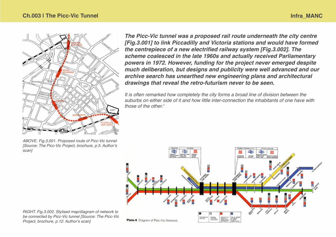
Ch.003 | The Picc-Vic Tunnel Infra_MANC
The Picc-Vic tunnel was a proposed rail route underneath the city centre [Fig.3.001] to link Piccadilly and Victoria stations and would have formed the centrepiece of a new electrified railway system [Fig.3.002]. The scheme coalesced in the late 1960s and actually received Parliamentary powers in 1972. However, funding for the project never emerged despite much deliberation, but designs and publicity were well advanced and our archive search has unearthed new engineering plans and architectural drawings that reveal the retro-futurism never to be seen.
It is often remarked how completely the city forms a broad line of division between the suburbs on either side of it and how little inter-connection the inhabitants of one have with those of the other.1
ABOVE. Fig.3.001. Proposed route of Picc-Vic tunnel [Source: The Picc-Vic Project, brochure, p.5. Author’s scan]
RIGHT. Fig.3.002. Stylised map/diagram of network to be connected by Picc-Vic tunnel [Source: The Picc-Vic Project, brochure, p.12. Author’s scan]

Infra_MANC Ch.003 | The Picc-Vic Tuunel
Disconnected city Many major cities in the twentieth century sought to smooth and speed the movement of their citizens within and across their metropolitan cores by digging railway tunnels and installing whole subway systems. This did not happen in Manchester and the city today stands in contrast to those who succeeded in building underground transport infrastructure; London, Liverpool, Newcastle, and Glasgow.
The reasons why the Picc-Vic railway tunnel was never constructed are unclear, there does not appear to be a single decisive moment when the project was either born or died. Its genesis is at least a couple of decades long, grown from earlier proposals and transport studies for Manchester city and the wider region, and it was postponed and delayed until it faded away in the late 1970s. One of the key problems post-war Manchester has suffered from is a lack of cross-city connectivity. [This was partially remediated by the arrival of Metrolink trams in 1992 and twenty years later is still being tackled with the proposed building of ‘Ordsall Chord’.] Ultimately the transport structure of the city rests upon the legacy of the competitive development of the Victorian railway era, when two, almost separate, systems, north and south of Manchester were constructed; the result was a number of mainline stations, but all at the edge of the central area of the city and with few links between them [see Fig.3.003]. It is also important to remember Manchester’s industrial past, and in particular its role in textile storage and distribution, whereby the railways had developed, primarily, to carry goods, not passengers and as such terminated near to the warehouses that had originally clustered around the canal basins; land was also cheaper and more easily acquired at the edge of the city.
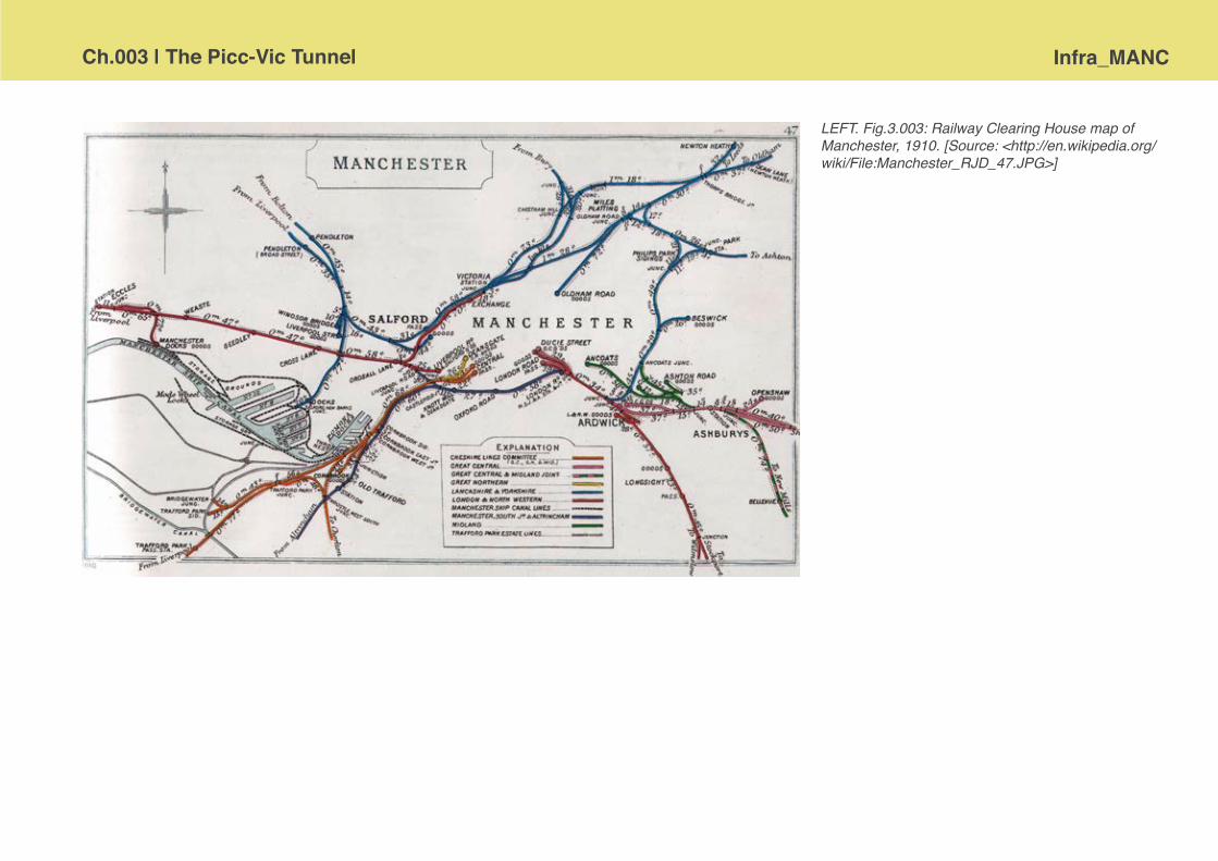
Ch.003 | The Picc-Vic Tunnel Infra_MANC
LEFT. Fig.3.003: Railway Clearing House map of Manchester, 1910. [Source: <http://en.wikipedia.org/wiki/File:Manchester_RJD_47.JPG>]
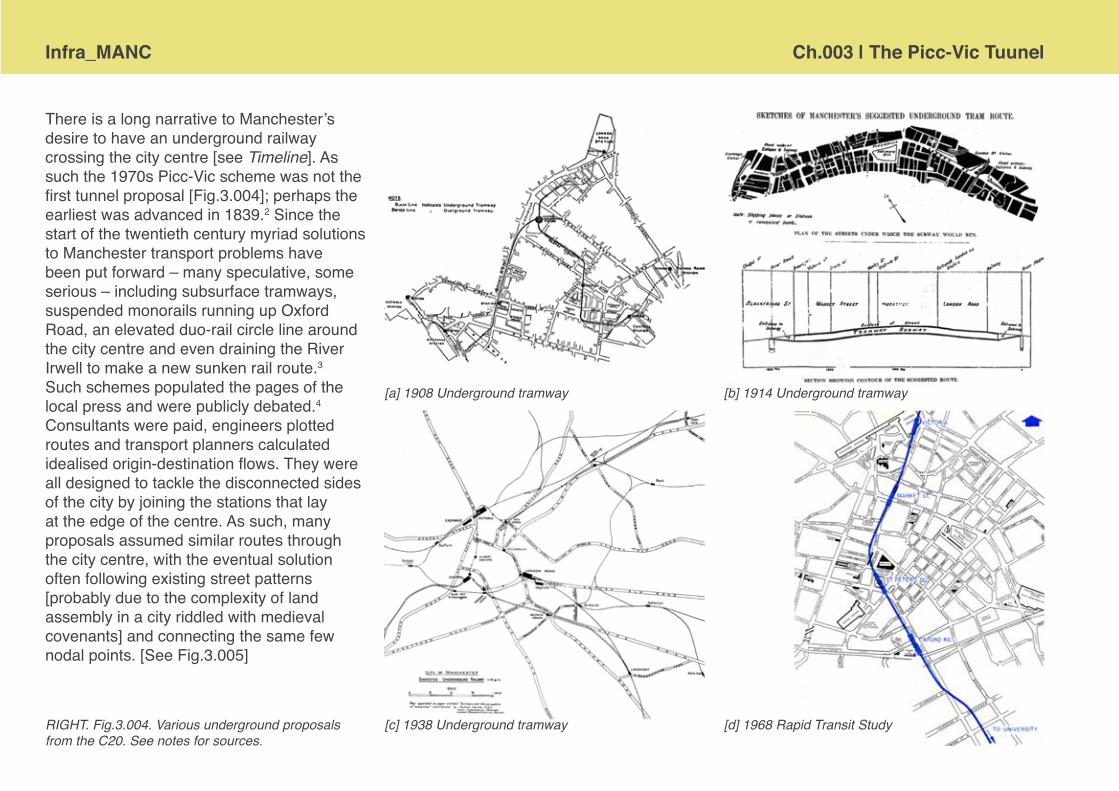
Infra_MANC Ch.003 | The Picc-Vic Tuunel
There is a long narrative to Manchester’s desire to have an underground railway crossing the city centre [see Timeline]. As such the 1970s Picc-Vic scheme was not the first tunnel proposal [Fig.3.004]; perhaps the earliest was advanced in 1839.2 Since the start of the twentieth century myriad solutions to Manchester transport problems have been put forward – many speculative, some serious – including subsurface tramways, suspended monorails running up Oxford Road, an elevated duo-rail circle line around the city centre and even draining the River Irwell to make a new sunken rail route.3 Such schemes populated the pages of the local press and were publicly debated.4 Consultants were paid, engineers plotted routes and transport planners calculated idealised origin-destination flows. They were all designed to tackle the disconnected sides of the city by joining the stations that lay at the edge of the centre. As such, many proposals assumed similar routes through the city centre, with the eventual solution often following existing street patterns [probably due to the complexity of land assembly in a city riddled with medieval covenants] and connecting the same few nodal points. [See Fig.3.005]
RIGHT. Fig.3.004. Various underground proposals from the C20. See notes for sources.
[a] 1908 Underground tramway [b] 1914 Underground tramway
[c] 1938 Underground tramway [d] 1968 Rapid Transit Study

Ch.003 | The Picc-Vic Tunnel Infra_MANC
RIGHT. Fig.3.005. Tunnels through time. Detailing some of the routes for proposed underground tram/railway links across Manchester city centre during the twentieth century. [Source: Authors compilation from original sources.]

Infra_MANC Ch.003 | The Picc-Vic Tuunel
Proposing solutions was one thing, but actually achieving the construction of major urban public transport infrastructure in Manchester, along with other British cities, has been a story of relative failure in the post-war period. This is due to the fact that for most of the twentieth century there was a certain amount of disassociation between transport planning for roads and that undertaken for the railways, largely due to the organisational structures of the respective governing bodies. Broadly speaking highways were in purview of the city officials and rails under the jurisdiction of national bureaucrats. This is evident in the cursory commentary concerning rail in each of the major town planning documents for Manchester from 1945 onwards, in contrast to their voluminous and detailed coverage of road building schemes.5 However, the transport needs of the conurbation were telling the politicians what shape of governance was required; the city of Manchester was indisputably the regional hub and was served by satellite towns, which, whether they liked it or not, were subservient to the economic centre. This de facto urban morphology prompted the formation of the South East Lancashire North East Cheshire [SELNEC] transportation study group in 1958.6

Ch.003 | The Picc-Vic Tunnel Infra_MANC
Necessary cohesion SELNEC, by necessity, somewhat pre-empted the emergence of regional government and strategies in its highway study of 1962 and crystallised the composition of what would become the Greater Manchester authority. Derek Senior, an influential journalist, who had trained as a planner, was making public calls for the creation of a new county authority in the mid-1960s, as he believed that the dreams and ambitions of the 1945 City of Manchester Plan called for coordinated transport plans and that without, the city would struggle to realise the comprehensive development set out.7 Moreover, Leslie Green’s book, Provincial Metropolis8 had established, what Senior considered to be, an irrefutable argument for the creation of a powerful city region authority. Such calls were not new, as early as 1915 Patrick Geddes had also made reference to ‘Greater Manchester’ as meaningful entity9 and the Manchester and District Joint Town Planning Advisory Committee was formed in 1921.10 [see Fig.3.004] In April 1935, the Manchester Evening Chronicle brought to the fore the issue of ‘regional unity’ under the headline ‘Greater Manchester – The Ratepayers’ Salvation’, claiming that there were ‘increasing demands for the exploration of the possibilities of a greater merger of public services throughout Manchester and the surrounding municipalities’.11 Part of the suite of reports in the wake of the second world war also took account of the regional morphology by consciously drawing together South Lancashire and North Cheshire.12 Eventually, following the Local Government Act of 1972 the wheels were set in motion for the inauguration of the new county of ‘Greater Manchester’ and subsequently a new set of municipal structures that would be forced to re-imagine the planning of the city in a transformed political and economic climate.
The transportation planning that culminated in the Picc-Vic project really began in 1962 with the publication of the SELNEC study, A Highway Plan.13 This led to the establishment of the SELNEC Area Land-use Transportation Study [SALTS] in 1963, which pioneered computer simulations.14 The Manchester Rapid Transit Study [MRTS], which examined routes from Ringway airport and Wythenshawe, through the city centre to Langley and was intended to connect the two biggest post-war overspill municipal housing estates, was carried out under the aegis of the SALTS between June 1966 and November 1968.15 A subsequent Rail Planning Study also by SELNEC16, questioned the comparative values of the rapid transit study and the possibility of the heavy rail tunnel against a monorail solution and concluded that a conventional electrified railway with central tunnel section was preferable as it would benefit the wider conurbation and that simulations and financial models showed ‘a better rate
LEFT. Fig.3.006. The sizable area of responsibility of the Manchester and District Joint Town Planning Advisory Committee, diagram showing volume of traffic on arterial routes. [Source: Authors scan from Heath, P.M. [ed.] [1922:11] A Record of the Town Plan-ning Exhibition and Conferences [Manchester: The Manchester and District Joint Town Planning Advisory Committee] p.11.]

Infra_MANC Ch.003 | The Picc-Vic Tuunel
of return’.17 If a Manchester Guardian report from 1970 is to be believed the city was ‘told to build underground’ by the computer running the simulations!18 [Such headlines, whilst distinctly technocratic, do in some senses capture the zeitgeist of that time in relation to avowedly rationalist and scientific approaches to urban planning]. The eventual long-term plan did not fully discount light rapid transit [LRT] as a part of the integrated transport solution for the conurbation; both the SELNEC Public Transport Plan for the Future [1973] and the The Picc-Vic Project [1975] brochure [Fig.3.007] continued to outline LRT as part of the approach to transport planning.19
RIGHT. Fig.3.007. Covers of Picc-Vic Project brochure in the early 1970s on rail infrastructure in Manchester. [Source: Author scans of original reports.]
FACING PAGE. Fig.3.008. The SELNEC Transportation Plan for 1984. This shows the aspirations of the Corporation in relation to the new powers that allowed them to plan for the integrated transport needs of the conurbation. [Source: authors scan of insert map from SELNEC [1972] A Broad Transportation Plan for 1984 [Manchester: Manchester Corporation]]

Ch.003 | The Picc-Vic Tunnel Infra_MANC
Aims and ambitions
A judicious policy of suburban railway electrification, coupled with a well- designed tube railway system, would go a long way towards making the population in and around Manchester happier and healthier.20
Under the direction of the multi-agency Tunnel Steering Committee based at the Passenger Transport Authority [PTA] in Manchester and in close collaboration with British Rail, London Midland Region at London Euston, the scheme that came to be known as the Picc-Vic plan was much broader in its scope than just the short underground section of railway between two mainline stations. As required by the 1968 Transport Act, Manchester sought to address land-use and transport planning in a comprehensive series of studies. Picc-Vic was conceived as a high volume electrified passenger line that would connect sixty miles of track into a new network [Fig.3.012] and, at the time, was the kingpin of a conurbation wide strategy for integrating transport modes and addressing serious issues of congestion that had arisen as car ownership surged and more freight depended on road haulage [see Fig.3.008 and Chapter 2 of this volume for discussion concerning highways infrastructure]. Other major works attached

Infra_MANC Ch.003 | The Picc-Vic Tuunel
to the proposals included the upgrading and electrification of feeder branch railway lines and the construction of new railway ‘flyover’ at Ardwick Junction to allow the slower Picc-Vic trains to cross the numerous ‘fast’ lines in and out of Piccadilly Station and ‘to the outside position necessary to serve Levenshulme and Heaton Chapel stations’21 without complicated signalling and points [Fig.3.009]. A second ‘flyover’ was also planned for Slade Lane to accommodate the north-bound Picc-Vic services [Fig.3.010]. A new signal box at Piccadilly, new rolling stock, investment in re-signalling to increase capacity, along with new interchanges at Bury and Altrincham, and innovative ‘park and ride’ facilities were all part of the proposed package. New depot facilities were also laid out on the site of the former tip at Queens Road [Fig.3.011], which in the 1950s had been under consideration for a heliport [see Chapter 1]. Bus services, stations and the integration of timetables were all investigated by the PTA anticipating the arrival of the key cross-city link provided by the new tunnel infrastructure; the blind faith of Manchester Corporation with respect carrying out their statutory duties with rigour and thoroughness cannot be questioned. Annals of studies, technical reports and publicity brochures that mechanically react to the continually shifting demands of the approval and funding contexts are material
ABOVE. Fig.3.009. Ardwick junction ‘flyover’. [Source: City Surveyor and Engineers plan archive, ref. 6658/-/10, GMCRO. Authors scan, courtesy of Manchester Archives and GMCRO.]
ABOVE. Fig.3.010. Slade Lane junction ‘flyover’. [Source: City Surveyor and Engineers plan archive, ref. 6658/-/6, GMCRO. Authors scan, courtesy of Manchester Archives and GMCRO.]

Ch.003 | The Picc-Vic Tunnel Infra_MANC
testament to the efforts of the regional sponsors and supporters of the Picc-Vic scheme as they sought ‘to secure or promote the provision of a properly integrated and efficient system of public passenger transport to meet the needs of the area and with due regard to the town planning and traffic parking policies of the councils of the constituent areas and to economy and safety of operation’.22 Overall the Picc-Vic scheme was intended to facilitate four major routes:
Wilmslow – Bolton [via Styal] Alderley Edge – Bury [via Stockport] Macclesfield – Victoria [via Stockport] Hazel Grove – Victoria [via Stockport]
Each of these routes would run a service with a frequency of ten minutes, which would provide an inner-city service of a train every two and a half minutes.
ABOVE. Fig.3.011. The proposed rolling stock depot at Queens Road. [Source: City Surveyor and Engineers plan archive, ref. 6658/-/7, GMCRO. Authors scan, courtesy of Manchester Archives and GMCRO.]
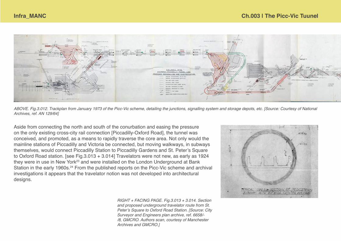
Infra_MANC Ch.003 | The Picc-Vic Tuunel
RIGHT + FACING PAGE. Fig.3.013 + 3.014. Section and proposed underground travelator route from St. Peter’s Square to Oxford Road Station. [Source: City Surveyor and Engineers plan archive, ref. 6658/-/8, GMCRO. Authors scan, courtesy of Manchester Archives and GMCRO.]
ABOVE. Fig.3.012. Trackplan from January 1973 of the Picc-Vic scheme, detailing the junctions, signalling system and storage depots, etc. [Source: Courtesy of National Archives, ref. AN 129/64]
Aside from connecting the north and south of the conurbation and easing the pressure on the only existing cross-city rail connection [Piccadilly-Oxford Road], the tunnel was conceived, and promoted, as a means to rapidly traverse the core area. Not only would the mainline stations of Piccadilly and Victoria be connected, but moving walkways, in subways themselves, would connect Piccadilly Station to Piccadilly Gardens and St. Peter’s Square to Oxford Road station. [see Fig.3.013 + 3.014] Travelators were not new, as early as 1924 they were in use in New York23 and were installed on the London Underground at Bank Station in the early 1960s.24 From the published reports on the Picc-Vic scheme and archival investigations it appears that the travelator notion was not developed into architectural designs.

Ch.003 | The Picc-Vic Tunnel Infra_MANC

Infra_MANC Ch.003 | The Picc-Vic Tuunel
ABOVE. Fig.3.015. Tunnel bore dimensions. [Source: City Surveyor and Engineers plan archive, ref. 6658/-/4, GMCRO. Authors scan, courtesy of Manchester Archives and GMCRO.]
The design of Picc-Vic tunnel and stations The Picc-Vic scheme was to be major piece of civil engineering. There would have been two bored tunnels through the red sandstone bedrock, each eighteen feet in diameter [Fig.3.00X], which connected with one another at the various stations. The cost estimate, at Januray 1973 levels, was £92,713,00 for the tunnel and all of the associated works.25 The route would run from Ardwick Junction in the south to Queens Road Junction in the north and provide new underground stations at Piccadilly lower level, Whitworth Street, ‘Central’ [the Town Hall and under the Central Library], Royal Exchange and Victoria lower level. This route partially adopted the earlier proposals of the LRT study [Fig.3.004d] and the same consultant civil engineers were appointed to the Picc-Vic team.26
Following the receipt of Parliamentary powers it was anticipated that a start on the construction works in September 1973 would see completion in January 1978 and allow four months of track testing before an official opening in May 1978.27 [see Fig.3.016 for programme diagram] Substantial engineering and detailed design work commenced at the end of 1971.28 The new section of railway was scheduled to be 2.75 miles [4.4km] long. 2.18 miles [3.5km] of this would be the tunnelled portion under the city centre. Aerial surveys and test boring to ascertain ground

Ch.003 | The Picc-Vic Tunnel Infra_MANC
ABOVE. Fig.3.016. An overview programme diagram for the main phases of construction of the Picc-Vic network. [Source: authors photography from correspondence held at the National Archives, ref. AN129/63]
RIGHT. Fig.3.017. Borehole testing 1972. [Source: Museum of Transport Greater Manchester. Uncatalogued photos held in SELNEC archive. Author’s scans]
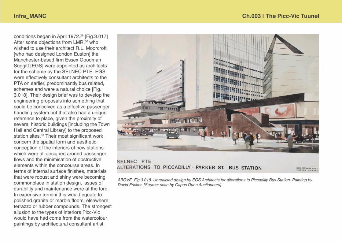
Infra_MANC Ch.003 | The Picc-Vic Tuunel
ABOVE. Fig.3.018. Unrealised design by EGS Architects for alterations to Piccadilly Bus Station. Painting by David Fricker. [Source: scan by Capes Dunn Auctioneers]
conditions began in April 1972.29 [Fig.3.017] After some objections from LMR,30 who wished to use their architect R.L. Moorcroft [who had designed London Euston] the Manchester-based firm Essex Goodman Suggitt [EGS] were appointed as architects for the scheme by the SELNEC PTE. EGS were effectively consultant architects to the PTA on earlier, predominantly bus related, schemes and were a natural choice [Fig. 3.018]. Their design brief was to develop the engineering proposals into something that could be conceived as a effective passenger handling system but that also had a unique reference to place, given the proximity of several historic buildings [including the Town Hall and Central Library] to the proposed station sites.31 Their most significant work concern the spatial form and aesthetic conception of the interiors of new stations which were all designed around passenger flows and the minimisation of obstructive elements within the concourse areas. In terms of internal surface finishes, materials that were robust and shiny were becoming commonplace in station design, issues of durability and maintenance were at the fore. In expensive termini this would equate to polished granite or marble floors, elsewhere terrazzo or rubber compounds. The strongest allusion to the types of interiors Picc-Vic would have had come from the watercolour paintings by architectural consultant artist
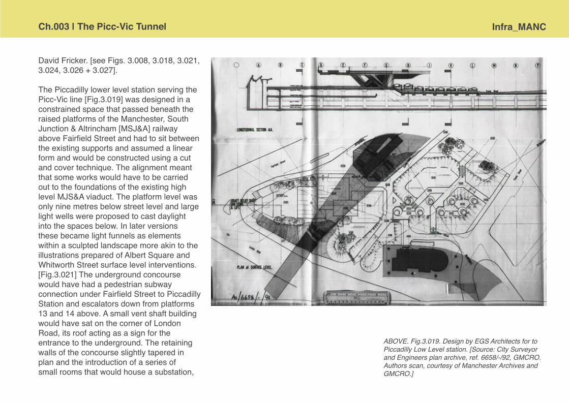
Ch.003 | The Picc-Vic Tunnel Infra_MANC
David Fricker. [see Figs. 3.008, 3.018, 3.021, 3.024, 3.026 + 3.027].
The Piccadilly lower level station serving the Picc-Vic line [Fig.3.019] was designed in a constrained space that passed beneath the raised platforms of the Manchester, South Junction & Altrincham [MSJ&A] railway above Fairfield Street and had to sit between the existing supports and assumed a linear form and would be constructed using a cut and cover technique. The alignment meant that some works would have to be carried out to the foundations of the existing high level MJS&A viaduct. The platform level was only nine metres below street level and large light wells were proposed to cast daylight into the spaces below. In later versions these became light funnels as elements within a sculpted landscape more akin to the illustrations prepared of Albert Square and Whitworth Street surface level interventions. [Fig.3.021] The underground concourse would have had a pedestrian subway connection under Fairfield Street to Piccadilly Station and escalators down from platforms 13 and 14 above. A small vent shaft building would have sat on the corner of London Road, its roof acting as a sign for the entrance to the underground. The retaining walls of the concourse slightly tapered in plan and the introduction of a series of small rooms that would house a substation,
ABOVE. Fig.3.019. Design by EGS Architects for to Piccadilly Low Level station. [Source: City Surveyor and Engineers plan archive, ref. 6658/-/92, GMCRO. Authors scan, courtesy of Manchester Archives and GMCRO.]

Infra_MANC Ch.003 | The Picc-Vic Tuunel
ABOVE. Fig.3.020. Sectional drawing of proposed Whitworth Street low level station. [Source: Courtesy David Suggitt, Darnton EGS]
ABOVE. Fig.3.021. Unrealised design by EGS Archi-tects for Whitworth Street. Painting by David Fricker. [Source: Courtesy David Suggitt, Darnton EGS]
employees changing area, cafe and other concessions allowed the architects to introduce curving forms that would direct the passenger flow.Whitworth Street station [Fig.3.020 + 3.021], at the junction with Princess Street, seems a bit of an oddity being barely 300m from Piccadilly lower level station and about one minute travel time away from the proposed Central station. BR had made proposals to combine Whitworth St. and Piccadilly to ease the tunnel gradients in 1971,32 but these seem to have fallen by the wayside as Manchester Corporation and the PTA pushed on. Early engineering drawings show the consideration that had to be given to existing subterranean routes, particularly around Whitworth Street, where the convergence of the relief culvert for Shooter’s Brook33 and the Duke’s Tunnel34 was taken into account [Fig.3.022]. The surface level station and the number of entrance points make this the simplest in design terms. The relatively unnassuming access pavilion integrated with a landscape solution that saw the surface level buildings as part of the broader public realm and formally and materially associated with planters and paviors; the soon to be unbiquitous brown tiles, used by EGS in their other work for the PTA, appear to coat every publicly visible surface. Architectural plans and sectional drawings [Fig.3.020] show a suspended canopy above the kiosks and escalator accesses, but the artists perspective does not. Without the drama of the canopies the proposal presents a very calm qualities that could plausibly be described as an ‘urban oasis’ [Fig.3.021]. Today Whitworth Street despite its grand warehouses is a rather charmless traffic thoroughfare.
ABOVE. Fig.3.022. Early plan of possible subterranean conflicts. [Source: City Surveyor and Engineers plan archive, ref. 6658/-/13, GMCRO. Authors scan, courtesy of Manchester Archives and GMCRO.]

Ch.003 | The Picc-Vic Tunnel Infra_MANC
The ‘Central’ station at the Town Hall was actually proposed to pass directly under the Central Library and was to provide access points from a multitude of directions including direct access from the proposed Clarendon Club on the site of what is currently the Peace Gardens [Fig.3.023]. The underground concourse plan responded accordingly and three giant mushroom columns were intended to collect and direct the passenger traffic in organic flows to the descent to the train platforms. Surface level interventions were designed for both St. Peter’s Square and Albert Square, the latter assuming terrain modelling in something akin to ‘Kubrick meets Tellytubbies’ visual language. [Fig.3.024] The access from St. Peter’s Square was a much more restrained
ABOVE. Fig.3.024. Unrealised design by EGS Archi-tects for access to Central Station from Albert Square. Painting by David Fricker. [Source: scan by Capes Dunn Auctioneers]
LEFT. Fig.3.023. Early plan for St. Peter’s Square. [Source: City Surveyor and Engineers plan archive, ref. 6658/-/13, GMCRO. Authors scan, courtesy of Manchester Archives and GMCRO.]

Infra_MANC Ch.003 | The Picc-Vic Tuunel
LEFT. Fig.3.023. Extract from early enginners drawing for Albert Sqaure showing access from station into Town Hall. [Source: City Surveyor and Engineers plan archive, ref. 6658/-/23, GMCRO. Author’s scan, courtesy of Manchester Archives and GMCRO.]
affair, glazed with very slender supporting columns and a ‘floating’ roof. [Fig.3.023] There were further proposed exits to Lower Mosley Street and Oxford Street from the St. Peter’s Square concourse level and a subway connection from Albert Square to the proposed Heron House development at the top of Brazenose Street. Earlier engineering drawings showed the station closer to Princess Street and with a connection into the Town Hall [Fig.3.024]. By December 1973 when EGS were contracted prepared the station design it would appear that the travelators in tunnels had become moving surface-level pavements; there is no annotation on the architect’s drawings to suggest that a low level connection would be made to any pedestrian tunnels other than those that connected the two concourse areas. [Fig.3.025]
ABOVE + RIGHT. Fig.3.024 + 3.025. Unrealised design by EGS Architects for access to Central Station from St. Peter’s Square. Painting by David Fricker. [Source: scan by Capes Dunn Auctioneers]

Ch.003 | The Picc-Vic Tunnel Infra_MANC
ABOVE. Fig.3.027. Extract from drawing showing proposed Knott Mill Line running right to left and Picc-Vic line ‘above’, running top to bottom. [Source: City Surveyor and Engineers plan archive, ref. 6658/-/5, GMCRO. Author’s scan, courtesy of Manchester Archives and GMCRO.]
FAR LEFT + LEFT. Fig.3.026. Photograph of void beneath Arndale Centre, built to provide connection to Picc-Vic Royal Exchange station [Source: Cour-tesy Charlotte Martin] Extract from Arndale drawing [Source: City Surveyor and Engineers plan archive, ref. 6558/-/28, GMCRO. Author’s scan, courtesy of Manchester Archives and GMCRO.]
Moving forward the trains would have sped on a relatively short distance to the third completely new Picc-Vic line station located at Royal Exchange. This station was intended to collect and distribute passengers from a number of surface streets, and to service the retail core. Direct access from the station was to be provided to the large Marks & Spencer’s store, to the Royal Exchange itself, the shops on the yet to be pedestrianised Market Street and, of course, the then newly opened Arndale Centre35. Once again curved walls were proposed that would direct the passenger flows, this time around a single huge feature column in the centre of the plan. At this point the tunnel route was to run almost directly below Cross Street at about twenty-one metres below street level. It is recorded that each of the new developments had measures in place in their designs to accommodate these connections and drawings and searches of the Arndale have revealed that such a subterranean void remains. [Fig.3.026] Rather alluringly, the early engineers drawings of this station show a second tunnel below, and perpendicular to, the Picc-Vic line carrying the title ‘Knott Mill Line’ [Fig.3.027]. The later architect’s information does not show this second tunnel in either plan or section, but does show a spur from the concourse level marked ‘Access to Line 2’. [Fig.3.028] The name would suggest that this second tunnel would head out via Deansgate Station, the likelihood being that it would connect to south bound Altrincham rail services.

Infra_MANC Ch.003 | The Picc-Vic Tuunel
ABOVE. Fig.3.029. Early watercolour sketches by David Fricker for Royal Exchange station concourse and platform. The platform sketch was developed as the cover image for the brochure shown in Fig. 3.08. [Source: scan by Capes Dunn Auctioneers]
ABOVE. Fig.3.028. Extract from EGS drawing for Royal Exchange Station showing access from concourse to ‘Line 2’. [Source: City Surveyor and Engineers plan archive, ref. 6658/-/23, GMCRO. Author’s scan, courtesy of Manchester Archives and GMCRO.]

Ch.003 | The Picc-Vic Tunnel Infra_MANC
From archival investigations we have conducted to date there is scant visual information concerning the design of connection at Victoria Station, the engineer’s drawings show a surface level addition to the end of the station at Long Millgate and a concourse under the point where the Metrolink line now enters Victoria [Fig.3.030]. Also conceived in terms of railway engineering, but without an architectural visual record were the tunnel portals at north and south entrances. The visual branding of the system in terms of logos and livery does not appear to have been advanced, different architectural renders show various train units and, other than the consistent use of brown tiles, there are no discernible repeat motifs in the paintings and drawings that have been studied. The only individual who might have had the licence to suppose a branded identity is Fricker and he does include a sign which bears passing resemblance to the BR logo on his St. Peter’s Square illustration. [Fig.3.031] Elevational drawings of the platform areas at Royal Exchange are fairly generic and do not reveal any bespoke or dedicated attention to the identity of the system below ground [Fig.3.032].
ABOVE. Fig.3.030. Extract from engineers drawing for Victoria Station. [Source: City Surveyor and Engineers plan archive, ref. 6658/-/13, GMCRO. Author’s scan, courtesy of Manchester Archives and GMCRO.]

Infra_MANC Ch.003 | The Picc-Vic Tuunel
ABOVE. Fig.3.031. Extract from artist’s drawing for St. Peter’s Square showing imagined logo. [Source: scan by Capes Dunn Auctioneers]
ABOVE. Fig.3.032. Elevational drawing of proposed Royal Exchange low level station. [Source: Darnton EGS archive. dwg.ref. M30/TJ/3. Courtesy David Suggitt.]
The designs of the trains themselves and their interior configuration and fit out were subject to speculation; the Picc-Vic brochure carried an image of the type of train proposed [Fig.3.033a] and in the October 1974 edition of Express, ‘The Staff Vehicle of Greater Manchester Transport’ it was asked, ‘Could the link between British Rail and Greater Manchester Transport mean - orange trains?’. Of course, eventually GMPTE trains were orange [Fig.3.033b] but without the retro-futurist styling of those deployed on the Tyne & Wear Metro [Fig.3.033c].

Ch.003 | The Picc-Vic Tunnel Infra_MANC
ABOVE. Fig.3.034. Publicity pamphlet [Source: Author’s scan. Courtesy George Turnbull.]
ABOVE. Fig.3.033 [b] GMPTE orange Pacer at Llandudno station, 1989. [Source: <http://www.flickr.com/photos/rpmarks/5598924040/>]
ABOVE. Fig.3.033 [c] Tyne + Wear Metro, Shiremoor, 1980. [Source: <http://www.flickr.com/photos/pin-zac55/3352061638/in/set-72157615194635734/>]
ABOVE. Fig.3.033 [a] BR High Density Multiple Unit as proposed for Picc-Vic line. [Source: Picc-Vic Project brochure. Author’s photograph]

Infra_MANC Ch.003 | The Picc-Vic Tuunel
ABOVE. Fig.3.035. Cartoon to illustrate the ease with which one may traverse the city. Buildings include Gateway House, Central Library, M&S and CIS Tower [Source: Author’s scan. Courtesy George Turnbull.]
RIGHT. Fig.3.036 [a]. Futurotue publicity machine, designed by A.H. Knowles and built by Pontin Electronics of Macclesfield. The machine is in the permanent collection of the Museum of Transport Greater Manchester [Source: Author’s photograph]

Ch.003 | The Picc-Vic Tunnel Infra_MANC
RIGHT. Fig.3.037. Drawing to show traffic signage required for junction closure at Royal Exchange [Source: City Surveyor and Engineers plan archive, ref. 6658/-/55, GMCRO. Author’s scan, courtesy of Manchester Archives and GMCRO.]
In many respects the engineering plans and architectural designs were incredibly well advanced before the project saw its first collapse; the documents with which to tender the construction contract were complete and when collated ran for two linear metres stacked half a metre high.36 Not only was there a significant amount of construction information, but the SELNEC marketing machine was in full effect and articles, fold-out explanatory leaflets and glossy brochures with colour images were being circulated to envision the scheme and convince the public as to its value [Fig.3.034]. For example Express, the GMT staff newsletter ran a double page spread in October 1974 with a lively cartoon that compressed the major features of the city into a single panorama. [Fig.3.035] Above ground the city is shown to be congested with motor traffic, below the train shortcuts the mayhem and has soothing, if slightly psychedelic, clouds mirrored in its shiny windows.
In Piccadilly railway station an interactive display had been commissioned and deployed. The fantastically named Futuroute machine [Fig.3.036a] assumed the identity of an arcade style machine and invited viewers to select their proposed cross-city journeys on the console buttons and would illuminate their choice on a stylised map display37 [Fig.3.036b]. Many other pragmatic details of a major infrastructure project seem to have been considered including the position of contractors accommodation. Provision had also been made for highways diversions to be in place during the construction phasing and road traffic signs had been scheduled as to their content and location [Fig.3.037]. The project had so much momentum in the early 1970s it must have seemed inevitable that it would proceed. However, this was not to be the case and a complex political landscape did not aid the translation of the Picc-Vic from lines on paper drawings and plans into solid concrete tunnels and steel rails.
LEFT FACING PAGE. Fig.3.036 [b]. Futurotue publicity machine, designed by A.H. Knowles and built by Pontin Electronics of Macclesfield. The machine is in the permanent collection of the Museum of Transport Greater Manchester [Source: Author’s photograph]

Infra_MANC Ch.003 | The Picc-Vic Tuunel
A period of complexity and change The Manchester Rapid Transit Study [MRTS], in three extensive volumes, had gone some considerable way to determining the depth of the tunnel for a rapid transit through the central area and sectional drawings of geological conditions and tunnel depths were provided in Volume 2A of the final report38. From the ‘Central’ [Town Hall] through to surfacing at Queens Road the two proposed routes were identical. It appears the steering committee adopted some of the earlier survey and engineering design work and integrated this into the Picc-Vic tunnel scheme. These efficiencies alongside the considerable amount of work done by SELNEC on the highways network [see Chapter 2] should have seen Manchester poised to leap into action as the 1968 Transport Act not only gave the newly created Passenger Transport Authorities [PTA] the powers to determine their own integrated transportation needs but also established the principle of government grants for transport authorities if uneconomic passenger services could be justified on social grounds. Inexplicably Merseyside and Tyneside beat Manchester to the finishing line and both had grants approved for their new underground systems before the funding system was substantially modified39.
The structure of the institutional bodies who would be charged with delivering Picc-Vic was in a state of almost constant flux during the 1960s and 1970s.The SELNEC Highway Committee [1962] gave way to the SELNEC Passenger Transport Authority [PTA] [1968] and then the Greater Manchester Passenger Transport Executive [GMPTE] [1973/4]. Plans for improvements were actually the responsibility of British Rail up to 1969, but only featured in local authority transportation plans in 1971.40 BR had been very much about efficiencies and station closures in the wake of the Beeching Report41; most of this had been achieved by the time strategic powers were in the hands of the GMPTE.42 It should also be considered that BR managers were not necessarily disposed to vigorously promote a major scheme that would probably be removed from their jurisdiction. It may be argued that this shift in responsibility is reflected in the sudden switch from a light rail to a heavy rail solution in the minds of the authority planners. The talk and studies, since the mid-1960s, had been almost exclusively of monorail, elevated duo-rail and LRT solutions, concluding with the MRTS in November 1968. In 1969 powers were transferred and within a year the heavy rail tunnel became the preferred option without the amount of investigation that LRT had already had. Somewhat perversely, within this period, it was reported that British Rail were also advancing their own plans for a heavy rail tunnel under the city at a cost of £5 million in tandem with the local authority’s monorail proposal43 – Manchester, it seems, could have had both above and
RIGHT FACING PAGE. Fig.3.038. Letter from John Peyton refusing infrastructure grant [Source: GMCRO. Uncatalogued GMPTE file marked ‘Transportation Picc-Vic, *TR5.3A closed’.]

Ch.003 | The Picc-Vic Tunnel Infra_MANC
below ground mass transit systems.In order to progress with the construction of the Picc-Vic tunnel it was necessary to put forward the SELNEC Bill to Parliament, the approved bill became the SELNEC [Manchester Central Area Railway etc.] Act, 1972 and was granted royal ascent on the 9th August. In parallel to the pursuit of statutory powers, proposals for funding and design development were also progressing. The first infrastructure grant was submitted in October 1971 and the detailed development and justification of this completed and appended by January 1973. However, the infrastructure grant application was eventually turned down in August 1973 by John Peyton, Minister for Transport Industries. [Fig.3.038] Peyton cited announcements of £500 million reduction in public expenditure by Chancellor of the Exchequer Anthony Barber and stated, ‘there is no room for a project as costly as Picc-Vic before 1975/76 at the earliest’.44
In the background, new legislation was coming into force and the Local Government Finance Act [1974] endorsed the shift from specific public transport project grants, payable under the Transport Act, to block grants based on an annual submission of a Transport Policy and Programme [TPP]. The grants that had already been awarded to the other metropolitan conurbations [e.g. Merseyside, Tyneside] were now superseded
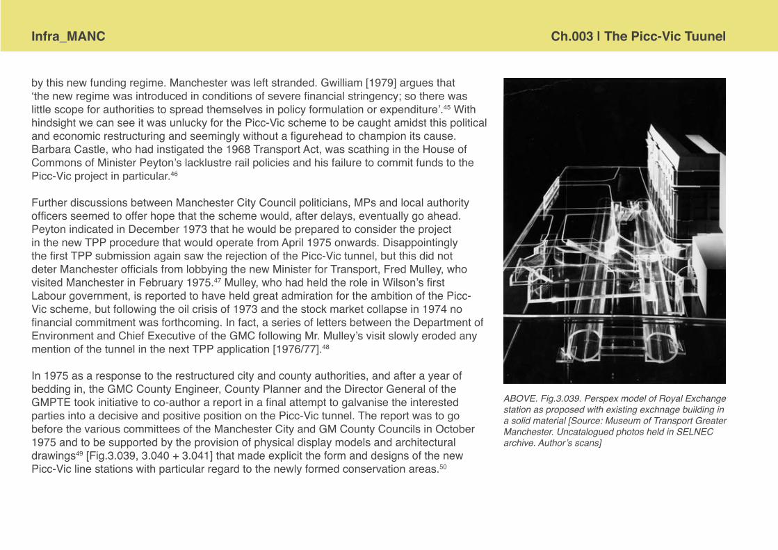
Infra_MANC Ch.003 | The Picc-Vic Tuunel
by this new funding regime. Manchester was left stranded. Gwilliam [1979] argues that ‘the new regime was introduced in conditions of severe financial stringency; so there was little scope for authorities to spread themselves in policy formulation or expenditure’.45 With hindsight we can see it was unlucky for the Picc-Vic scheme to be caught amidst this political and economic restructuring and seemingly without a figurehead to champion its cause. Barbara Castle, who had instigated the 1968 Transport Act, was scathing in the House of Commons of Minister Peyton’s lacklustre rail policies and his failure to commit funds to the Picc-Vic project in particular.46
Further discussions between Manchester City Council politicians, MPs and local authority officers seemed to offer hope that the scheme would, after delays, eventually go ahead. Peyton indicated in December 1973 that he would be prepared to consider the project in the new TPP procedure that would operate from April 1975 onwards. Disappointingly the first TPP submission again saw the rejection of the Picc-Vic tunnel, but this did not deter Manchester officials from lobbying the new Minister for Transport, Fred Mulley, who visited Manchester in February 1975.47 Mulley, who had held the role in Wilson’s first Labour government, is reported to have held great admiration for the ambition of the Picc-Vic scheme, but following the oil crisis of 1973 and the stock market collapse in 1974 no financial commitment was forthcoming. In fact, a series of letters between the Department of Environment and Chief Executive of the GMC following Mr. Mulley’s visit slowly eroded any mention of the tunnel in the next TPP application [1976/77].48
In 1975 as a response to the restructured city and county authorities, and after a year of bedding in, the GMC County Engineer, County Planner and the Director General of the GMPTE took initiative to co-author a report in a final attempt to galvanise the interested parties into a decisive and positive position on the Picc-Vic tunnel. The report was to go before the various committees of the Manchester City and GM County Councils in October 1975 and to be supported by the provision of physical display models and architectural drawings49 [Fig.3.039, 3.040 + 3.041] that made explicit the form and designs of the new Picc-Vic line stations with particular regard to the newly formed conservation areas.50
ABOVE. Fig.3.039. Perspex model of Royal Exchange station as proposed with existing exchnage building in a solid material [Source: Museum of Transport Greater Manchester. Uncatalogued photos held in SELNEC archive. Author’s scans]

Ch.003 | The Picc-Vic Tunnel Infra_MANC
ABOVE. Fig.3.040. Perspex model of Royal Exchange station as proposed with existing exchnage building in a solid material [Source: Museum of Transport Greater Manchester. Uncatalogued photos held in SELNEC archive. Author’s scans]
ABOVE. Fig.3.041. From left to right: Sir Robert Thomas, Leader of GMC, Fred Mulley, Minister of Transport, George Mann, Chairman of GMC Transportation Committee and Angus Munro, Director of Planning, GMT, all inspect a model on the occassion of Mr. Mulley’s visit to Manchester, February 1975. [Source: Museum of Transport Greater Manchester. Uncatalogued photos held in SELNEC archive. Author’s scans]

Infra_MANC Ch.003 | The Picc-Vic Tuunel
It is also notable that the GMC County Structure Plan [1975] still highlighted the Picc-Vic railway scheme as one of its ‘commitments’, but in January of that year the Guardian had already proclaimed that ‘Road lobby killed rail tunnel link’.51 George Mann, chairman of the GMC transport committee is reported to have blamed the Department of the Environment’s road programme as having eaten up funds and local MPs are also chastised for not having ‘pressed the scheme as hard as they might’.
The end of the line Eventually, in 1977, the newly elected Conservative-controlled GM County Council announced that they would not continue to support the idea of the city centre railway tunnel and instead began to focus their attention on a connection between Manchester’s two key stations above ground known as the Castlefield Curve.52 Following the demise of the large scale Picc-Vic scheme, it was all that GMPTE could do to promote the jolly little buses that carried passengers between stations under the name of Centreline. [Fig.3.042] This kind of service continues today with free Metro Shuttle buses, primarily to shift shoppers to and from the train stations and retail core.
LEFT. Fig.3.042. Seddon Minibus on the Centreline bus link [Source: Courtesy Cliff Beeton. Flickr - Cliffthemilk]
Ch.003 | The Picc-Vic Tunnel Infra_MANC
It seems as if the proposals relating to the Picc-Vic tunnels simply ran out of steam, dogged by shifting responsibilities, changing personnel and national political agendas. There are other factors said to have contributed to the lack of success of the scheme. One source suggests that rail transport was already disadvantaged in the 1960s by the attitude of the General Manager of Manchester Corporation Transport [MCT] who favoured bus travel and tried to subtly discredit rail based urban transport solutions.53 Another proposal was that the Tyne and Wear Metro, already under construction, was showing significant cost overruns and this impacted on Manchester’s funding ambitions. The editor of the Railway Gazette International in a letter to the editor of The Guardian in 1974 puts the blame for the delays to implement the scheme firmly with British Rail, stating that ‘Picc-Vic planning has also been bedevilled by the Railway Board’s determination to give absolute priority to inter-city passengers. If local trains might conflict with projected high-speed schedules for 1988, the PTE must pay now for extra tracks and signalling. This kind of thinking has inflated the cost of the Picc-Vic scheme to £100 millions’.54 This type of tension between the local PTEs and British Rail possibly contributed to personality clashes that are alluded to by some of the language used in internal correspondence during the early 1970s and is unlikely to have smoothed the rails in pursuit of shared objectives.
There were vague, half rumours that the Guardian Underground Telephone Exchange [GUTE] may also have had its own impact on the Picc-Vic proposals. The exact depth of the GUTE and its associated tunnels was never made public for reasons of security, even when local authorities made the specific request they were kept in the dark by the GPO.55 Estimates based on published facts concerning memos about safe depths for construction and safe clearances above tunnelled structures would suggest that the cable tunnel spurs of the GUTE run at a depth of about ninety feet below the surface. This is almost exactly the depth of the platform level of the proposed Picc-Vic tunnel at the ‘Central’ [Town Hall] and Royal Exchange stations.56 However, the actuality was that those involved did know the depth and route of the GUTE tunnel, but even though it had been declassified in 1968, still had to sign the official secrets act and could not indicate its position on any drawings.

Infra_MANC Ch.003 | The Picc-Vic Tuunel
Routes into the future
‘The most notable [recent] development in Manchester’s local rail network has been the solution to the problem of the need to modernize its two oldest, electrified commuter routes—those out to Altrincham and Bury. These were converted into Metrolink, light rail routes connected by a short street running section across the city centre, providing an imaginative, though only partial, solution to the separation of the north and south networks.’57
Travelling into the early 1980s and the struggle to provide an effective rail connection across Manchester city centre continued to stew behind the scenes. In 1982 a new group of technocrat planners was brought together to consider rail strategy. They presented a series of reports to GMC, GMPTE and BR on the various options available, including a intersecting tunnels to join Deansgate to Piccadilly Station, and Piccadilly to Victoria Station58. However, the favoured solution from this review of transport strategy was for light rail using trams that could cheaply exploit existing railway lines and run through the city along centre on surface streets. These studies fed directly into the conception and design of Metrolink which progresses through the mid 1980s, with proposal submitted to Whitehall for funding support and route plans deposited as part of LRT Bill to Parliament.
The Metrolink scheme received central government approval in 1988 and funding following the next year [Fig.3.043]. Construction took three years and Manchester’s new LTR system opened to passengers, on the Bury to Victoria segment, in April 1992. The scale of the infrastructure appears to be really rather modest in the urban landscape, with the station stops in the city centre being strictly functional. The return of trams to Manchester streets, after
RIGHT. Fig.3.043. The front of a promotional leaflet from GMPTE launching the Metrolink to the general public. [Source: Scan courtesy of Mike Ashworth, <http://www.flickr.com/photos/36844288@N00/6566194403/>]

Ch.003 | The Picc-Vic Tunnel Infra_MANC
a gap of 43 years, was generally welcomed and it finally provided a link between the rail two mainline stations, although only via the dead-end offshoot to new tram stop fitted neatly into the undercroft of Piccadilly Station. [Fig.3.044]
There were also a series of relatively minor, but noteworthy, developments in the railway infrastructure in Manchester overlapping with the construction and opening of Metrolink. In 1988 the so-called Windsor Link opened to allow transpennine trains a through route past Piccadilly station. While the new rail spur Manchester airport and the airport station [designed by Austin-Smith:Lord architects] is small in distance terms but has proved to be very effective since opening in 1993. Piccadilly station itself underwent a major cosmetic redesign by BDP of the passenger concourse at the start of the millennium, and in time for the 2002 Commonwealth Games, to become as much a shopping centre as a place to catch trains. Prior to this EGS had designed the new roof to the train shed and the sattelite lounge and travelators to platforms 13 & 14.
RIGHT. Fig.3.044.The route of Metrolink along surface streets in Manchester city centre and connections to railway stations. [Source: Author scan from Tyson, W.J. [1992: 145] ‘Planning and financing Manchester Metrolink’, in Proceedings of the Institution of Civil Engineers Transportation 92 pp.141-50]

Infra_MANC Ch.003 | The Picc-Vic Tuunel
Metrolink has been a moderate success, as kind of stop-gap measure, but as yet it remains far from a comprehensive solution to the transport needs of the metropolitan area. Since the initial routes between Altrincham and Bury opened in 1992 the authorities have struggled to get desired extensions to the Metrolink financed and constructed. Eventually in 2001 the route west to Salford Quays and Eccles was opened. More recently a tiny spur to link to the shiny offices of MediaCity was tacked on. Currently further extensions are progressing south towards Didsburyite suburbia and across the vast expanse of east Manchester towards Ashton. As yet Metrolink still fails to connect to either the airport or the Trafford Centre. [Fig.3.045] [In many respects tt is a pale comparison to the 1920s heyday of Manchester trams!] The confluence of trams into single track route through the city centre has also resulted in a significant capacity crunch and the transport authorities are conducting a public consultation on the planned route for a second city crossing. Investment in a much larger scale expansion of Metrolink, along with other aligned public transport infrastructure, was scuppered in December 2008 when the public referendum rejected the vehicle congestion charge scheme and thereby negated the GMA’s multi-billion pound bid to the Transport Innovation Fund.
Queens Road
Kingsway Busin
ess Park
Oldham MumpsTemporary
Temporary line
Trafford Centre
Trafford Quays
Salford Reds
Port Salford
Lostock Parkway
Parkway Circle
Village
Imperial War
Museum
Manchester United
Oldham Mumps
Oldham Central
Oldham King Street
Westwood
Audenshaw
Ashton Moss
Ashton West
Ashton-under-Lyne
Withingto
n
West Didsb
ury
Burton Road
Didsbury Villa
ge
East Didsb
ury
Barlow M
oor Road
Sale Water P
ark
Northern
Moor
Wythensh
awe Park
Moor Road
BaguleyRoundth
orn
Benchill
CrossacresHaveley
Wythensh
awe Town Centre
Shadowmoss
Peel Hall
Robinswood Road
ManchesterAirport
Rochdale Railway Statio
n
Rochdale Town Centre
Newbold
Milnrow
Newhey
Shaw and Crompton
Derker
Freehold
Monsall
Newton Heath and Moston
Central Park
Failsworth
Hollinwood
South Chadderton
New Islington
Holt Town
Eastlands City Stadium
Velopark
Clayton Hall
Edge Lane
Cemetery Road
Droylsden
Chorlton
Firswood
St Werb
urgh’s Road
Broadway
Harbour C
ity
Anchorage
Salford
Quays
Exchange Quay
Eccles
Ladywell
Weaste
Langworthy
Whitefield
Besses o
' th' B
arn
Prestwich
Bury
Radcliffe
Heaton Park
Bowker Vale
Crumpsa
ll
Woodlands Road
Pomona
St Peter’s
Square
Mosley Stre
et
(south
bound only)
CornbrookPiccadilly Gardens
Trafford BarOld Trafford
StretfordDane RoadSale
BrooklandsTimperley
Navigation RoadAltrincham
Piccadilly
Victoria
Market Street
Shudehill
MediaCityUK
Deansgate-
Castlefield
(formerly GMEX)
Abraham Moss
© GMPTE 2011 10-1080-1113618
Some stop names subject to confirmation
Metrolink Network
Existing Metrolink
Metrolink extensions under construction
Proposed second city crossing (funded)
Metrolink extension subject to funding & approval
Possible new Metrolink stop
RIGHT. Fig.3.045.Schematic map of the Metrolink, with proposed extensions shown. [Source: pdf file provided on the Great Manchester Passenger Transport Executive website [2011].]

Ch.003 | The Picc-Vic Tunnel Infra_MANC
In just the last year there has been a new initiative from Network Rail to provide a direct heavy rail route between Victoria and Piccadilly stations. As part of a package of investment in rail infrastructure in the Northern region there are now firm plans to spend around £85 million on the so-called ‘Ordsall Chord’, a short new rail segment linking together Deansgate and Salford Central with the track running behind MOSI and Granada Studio, crossing the Irwell and Trinity Way59 [Fig.3.046]. The origins of this idea go back to the late 1970s and Parliamentary powers were originally granted in 1979. As with many infrastructural proposals authorship is uncertain, but a letter from the chairman of Bury Ratepayers Association to G.M. Tideswell, County Secretary, appears to be the first record of the route. The letter is marked with a hand annotated note; ‘active consideration for this pending Picc-Vic’ [Fig.3.047], thus, K.F. Whyman of Bury may well have seen the future from his home office in 1975! The provision of the ‘chord’ seems like an effective upgrade although rather unexciting in comparison to Manchester’s desire for an underground railway, but certainly much cheaper than twin bore tunnelling envisioned in the early 1970s …
ABOVE. Fig.3.046. The route line of the Ordsall Chord [Source: Network Rail <http://www.networkrail.co.uk/north/Ordsall-Chord.aspx>.]
ABOVE RIGHT + RIGHT. Fig.3.047. Sketch map and extract from correspondence between Mr. Whyman of Bury and Mr. Tideswell of the GMC. [Source: Author’s photographs. Uncatalogued GMPTE file marked ‘Transportation Picc-Vic, *TR5.3B closed’]
Infra_MANC Ch.003 | The Picc-Vic Tuunel
1 Harrison, W. [1882] A History of Manchester’s Railways [Manchester: Lancashire and Cheshire Antiquarian Society], Reprint 1967.
2 Holt, D. [1992] Manchester Metrolink. UK Light Rail Systems No.1 [Sheffiled: Platform Publishing], p.4.
3 ‘Sketches of Manchester’s suggested underground tram route’, Manchester Guardian, 14 March 1914, p.11; ‘City could have 50mph monorail by 1971’, Manchester Evening News, 30 November 1965; Duorail for Manchester,[1966] by Manchester Area Transit Investigation Committee [copy held at the National Archives, ref. MT 124/1088]; ‘The Irwell as thoroughfare’, Manchester Guardian, 1 February 1924, p.10.
4 See, for example, ‘The proposed Manchester underground railway’, Manchester Guardian, 5 May 1903, p.12; ‘Scheme for underground railways’, Manchester Guardian, 13 September 1927, p. 11; ‘A Manchester tube railway?’, Manchester Guardian, 10 January 1936, pp. 11; ‘Underground line needed ‘to save city from decline’’, The Guardian, 8 November 1967, p.6.
5 For a detailed account of these structures see Haywood, R. [2007] ‘Mind the gap: Town planning and Manchester’s local railway network: 1947–1996’ in European Planning Studies, 6[2], pp. 187-210.
6 SELNEC [1962] S.E.L.N.E.C. A Highway Plan [Manchester: South-East Lancashire and North-East Cheshire Area Highway Engineering Committee], p.1.
7 ‘New heart for Manchester’, The Guardian, 15 June 1960, p.18.
8 Green, L.P. [1959] Provincial Metropolis: The future of local government in South-East Lancashire; a study in metropolitan analysis [London : Allen & Unwin].
9 Geddes, P. [1915] Cities in Evolution [London: Association for Planning and Regional Reconstruction] New and revised edition, 1949, p.15. Geddes version had Liverpool as the port of the conurbation, subservient to Manchester, a situation that John Millar [MCC Chief Planner] acknowledged would antagonise Liverpudlians in his article: Millar, J.S. [1968] Manchester City Region. Paper delivered to the Town and Country Planning School at the University of Manchester, 1968. [Copy held at RIBA Library, Box 711.4 (42.72M):711.3]
10 Heath, P.M. [ed.] [1922] A Record of the Town Planning Exhibition and Conferences [Manchester: The Manchester and District Joint Town Planning Advisory Committee]
11 Quoted in Frangopulo, N.J. [1977: 277] Tradition in Action: The historical evolution of the Greater Manchester County [Wakefield: EP Publishing].
12 Nicholas, R. and Hellier, M.J. [1947] South Lancashire and North Cheshire. An Advisory Plan [Manchester: The Advisory Committee].
13 SELNEC [1962] S.E.L.N.E.C. A Highway Plan [Manchester: South-East Lancashire and North-East Cheshire Area Highway Engineering Committee]. Discussed further in Chapter 2.
14 The SELNEC Transportation Study produced huge volumes of guidance, reports and summaries during the period 1962-1973. Copies of a significant number of the Technical Working papers are held in the local studies collection of Manchester Metropolitant University library. Rail planning only emerged in the documents prepared in 1968. SELNEC Transportation Study [1968] Technical working paper, No.2, Rail planning study [Manchester: SELNEC].
15 Harrison, G.A., Hayes, J., Millar, J. [1975] Piccadilly-Victoria Tunnel Network, Report of the Transportation Strategy Joint Committee, 1975 held at GMCRO. Uncatalogued GMPTE file marked ‘Transportation Picc-Vic, *TR5.3A closed’
16 See are Manchester Rapid Transit Study reports: Manchester rapid transit study; Vol.1, Report of the working party Hennessey, Chadwick, O Heocha and Partners; De Leuw, Cather & Partners Published Manchester : Manchester City Transport 1967. Manchester rapid transit study, vol. 2, study of rapid transit systems and concepts De Leuw, Cather and Partners; 1967 Manchester rapid transit study; Vol.3, Reports of the working party and the consultants Hennessey, Chadwick, O Heocha and Partners; De Leuw, Cather & Partners. Published Manchester : Manchester City Transport 1968.
17 Greater Manchester County Council/SELENC PTA [1973] Piccadilly-Victoria Rail System and Central Manchester Rail Tunnel. Report held at GMCRO. Uncatalogued GMPTE file marked ‘Transportation Picc-Vic, *TR5.3B closed’.
18 ‘Manchester told to build underground’, The Guardian, 9 October 1970, p.26.
19 SELNEC PTA [1973] Public Transport Plan for the Future [Manchester: SELNEC].
Ch.003 | The Picc-Vic Tunnel Infra_MANC
20 ‘A Manchester tube railway?’, Manchester Guardian, 10 January 1936, pp. 11.
21 Harrison, G.A., Hayes, J. and Millar, J. [1975] Piccadilly-Victoria Tunnel Network, Report of the Transportation Strategy Joint Committee, 1975 held at GMCRO. Uncatalogued GMPTE file marked ‘Transportation Picc-Vic, *TR5.3A closed’.
22 1968 Transport Act. Part II, Cl. 3b, p. 14. Available at <http://www.legislation.gov.uk/ukpga/1968/73/enacted> [Accessed 29 january 2012].
23 See ‘Travolator 1924’ archive film with British Pathe viewed online at http://www.britishpathe.com/video/travolator/query/travolator [Accessed 3 February 2012]
24 http://www.britishpathe.com/video/drain-gets-new-look/query/travolator [Accessed 3 February 2012]
25 File held at National Archives. AN 129/62 Transport facilities Manchester conurbations: includes copy of Selnec (Manchester Central Area Railway etc) Bill 1971 . By February 1975 this was £105 million, according to Harrison, G.A., Hayes, J. and Millar, J. [1975] Piccadilly-Victoria Tunnel Network, Report of the Transportation Strategy Joint Committee, 1975 held at GMCRO. Uncatalogued GMPTE file marked ‘Transportation Picc-Vic, *TR5.3A closed’.
26 De Leuw, Cather & Partners – Hennessy, Chadwick, O hEocha & Partners, eventually became De [Manchester: The Advisory Committee] An Advisory Plan [ook account of the regional morphology drawing together Sotuh Lancashir eLeuw, Chadwick O hEocha.
27 Harrison, G.A., Hayes, J. and Millar, J. [1975] Piccadilly-Victoria Tunnel Network, Report of the Transportation Strategy Joint Committee, 1975 held at GMCRO. Uncatalogued GMPTE file marked ‘Transportation Picc-Vic, *TR5.3A closed’.
28 Piccadilly-Victoria Tunnel Network Infrastructure Grant Application [Source: GMCRO. Uncatalogued GMPTE file marked ‘Transportation Picc-Vic, *TR5.3B closed’].
29 ‘Start on city rail tunnel’, The Guardian, 13 April 1972, p.28.
30 Correspondence between G.A. Harrison of SELNEC PTE and J. Bonham-Carter of LMR eventually settles on the appointment of EGS in October 1972. File held at National Archives. AN 18/2120.
31 Interview with Clive Mainwaring, Project Architect, Essex Goodman Suggitt. September 15th 2011.
32 Annotaion on City Engineer’s drawing no. G/6658/-/11 made by ‘BR-LMR Euston’ and dated June 1971. From City Surveyor and Engineers plan archive, ref. 6658/-/11, GMCRO.
33 Shooter’s Brook is a tributary of the River Medlock, long since covered and culverted out of the visible city. See Ashworth, G. [1987] The Lost Rivers of Manchester [Altrincham: Willow Publishing].
34 The Duke’s Tunnel is thought to connect the site of a former coal wharf at Piccadilly with the River Medlock. The usefulness of such a connection is queried by some and it is suggested that the idea of the ‘tunnel’ has been created by evidence based assumptions and is somehow mixed up with the known culvert of Shooter’s Brook. The drawing shown in Fig.3.00X seems to show that the two exist side by side and that the engineers had information relating to their respective positions. See <http://www.penninewaterways.co.uk/board/yabb2/YaBB.pl?num=1123604076> for further discussion.
35 See Parkinson-Bailey J.J. [2000] Manchester: An Architectural History [Manchester: Manchester University Press].
36 Interview with Clive Mainwaring, Project Architect [retired], Essex Goodman Suggitt. September 15th 2011.
37 The Futuroute machine is now in the care of the Museum of Transport, Greater Manchester.
38 De Leuw, Cather and Partners [1967] Manchester Rapid Transit Study, Vol. 2, study of rapid transit systems and concepts [Manchester: Manchester City Transport].
39 In the case of Tyneside the financial viability of their Metro was confirmed by December 1972 and, following extensive lobbying by the Tyne and Wear PTA, local authorities and politicians throughout the region, the Government agreed to a seventy-five percent grant towards the cost of building the NE system. See The history of Metro, <http://www.nexus.org.uk/history/history-metro>.
40 Greater Manchester Council [1975] County Structure Plan. Report of Survey. Transportation, July 1975, p.61.

Infra_MANC Ch.003 | The Picc-Vic Tuunel
41 Beeching, Dr. R. [1963] The Reshaping of British Railways [London: HMSO] Although this report also proposed new modes of freight service and the modernisation of trunk passenger routes, it is remembered for recommending wholesale closure of what it considered little-used and unprofitable railway lines, the removal of stopping passenger trains and closure of local stations on other lines that remained open.
42 Haywood, R. [2009] Railways, Urban Development and Town Planning in Britain: 1948-2008 [Farnham: Ashgate], p.241.
43 ‘£5M rail tunnel to link two main line city stations’, The Guardian, 18 July 1967, p.1.
44 Letter held at GMCRO from Peyton to Sir George Ogden. Uncatalogued GMPTE file marked ‘Transportation Picc-Vic, *TR5.3B closed’.
45 Gwilliam, K.M. [1979] ‘Institutions and objectives in transport policy’ in Journal of Transport Ecomnomics and Policy, XIII[1], pp.14-15.
46 House of Commons debate 04 July 1973. Vol. 859, cc540-605. Viewed at <http://hansard.millbanksystems.com/commons/1973/jul/04/railways#S5CV0859P0_19730704_HOC_240> [Accessed 4 January 2012] ‘…I ask him why he is dragging his feet over a similar scheme in the SELNEC Passenger Transport Authority, in the Manchester area, where the authority got powers a year ago to build a rapid transit scheme linking the commuter rail services north and south of the city by a central area rail tunnel. This requires a grant of £70 million, consisting of £40 million for the tunnel and £30 million for upgrading 35 miles of existing track and increasing its reliability. The authority is ready to go to contract. It went to see the right hon. Gentleman about it last month, yet he has still not announced his willingness to give a grant.’
47 Letters held at GMCRO. Uncatalogued GMPTE file marked ‘Transportation Picc-Vic, *TR5.3A closed’.
48 Ibid.
49 Harrison, G.A., Hayes, J. and Millar, J. [1975] Piccadilly-Victoria Tunnel Network, Report of the Transportation Strategy Joint Committee, 1975 held at GMCRO. Uncatalogued GMPTE file marked ‘Transportation Picc-Vic, *TR5.3A closed’.
50 Manchester’s first conservation area designations were in 1970, following the Civic Amenities Act of 1969 which afforded protection to ‘areas of special architectural or historic interest, the character or appearance of which it is desirable to preserve or enhance’. They included St. Anne’s Square and Upper King Street.
51 ‘Road lobby killed tunnel link’, The Guardian, 15 January 1975, p.6.
52 White, H.P. [1980] ‘Transport Change’ in White H.P. [Ed.] The Continuing Conurbation. Change and Development in Greater Manchester [Salford: Gower Publishing Company], p.118.
53 Leatherbarrow, J. [1984] ‘Still waiting for the tube’ in Town & Country Planning, October, pp.278-9.
54 ‘Railways’ local motives’ [letter from Hope, R. to the editor] The Guardian, 21 September 1974, p.10.
55 See Chapter 4 of this volume.
56 Parliamentary drawings to accompany SELNEC [Manchester Central Area Railway etc.] Act, 1972. A Copy is held by Museum of Transport, Greater Manchester.
57 Haywood, R. [2007: 198] ‘Mind the gap: Town planning and Manchester’s local railway network: 1947–1996’ in European Planning Studies, 6[2], pp. 187-210.
58 Rail Study Group [1984] Greater Manchester Rail Strategy Study, Third Report [Greater Manchester Council].
59 ‘The missing link: rail line between Manchester Piccadilly And Victoria stations to boost jobs and business’, Manchester Evening News, 5 April 2011.

Ch.003 | The Picc-Vic Tunnel Infra_MANC
Infra_MANC Ch.004 | Guardian Underground Telephone Exchange
GUARDIAN UNDERGROUND TELEPHONE
EXCHANGE1

Ch.004 | Guardian Underground Telephone Exchange Infra_MANC
Under the heart of Manchester city centre lies a network of reinforced concrete tunnels known as the Guardian Underground Telephone Exchange [GUTE]. Today, this ageing relic from the beginnings of the Cold War era still operates silently as an infrastructure space facilitating the communications of those above. Surprisingly little information regarding the Guardian is readily accessible and the subterranean nature of the structure acts to entomb the reality of the network’s operation. A lack of concrete information allows facts to be supplanted by myths, fostering numerous [mis]perceptions of the same intangible space. The GUTE was conceived during a time of escalating international tensions in the mid 1950s as a ‘hardened’ bunker to protect vital national communication links in the event of an atomic bomb attack upon Manchester. However, this defining characteristic of protection was lost once construction was complete in 1958 as advances in nuclear weapons yield and the accuracy of ICB missiles rendered the tunnels ineffective for their primary defensive purpose. The bombproof tunnels still exist but the condition of nuclear confrontation does not.
The way to win an atomic war is to make certain it never starts.
US Army General, Omar N. Bradley [1893-1981]
ABOVE. Fig.4.001. The logo of the General Post Office, the organisation responsible for the construction and operation of the GUTE. [Source: <http://postalheritage.wordpress.com/2009/10/05/40th-anniversary-of-the-post-office-act-1969/>, courtesy of the British Postal Museum & Archive]

Infra_MANC Ch.004 | Guardian Underground Telephone Exchange
Cold War defensive constructions and communications
Whilst the Cold War did not involve any direct military exchanges between the two super powers, it did provoke defensive preparations for war on a massive scale, including huge investment in nuclear weapons technology and delivery systems. The result is a global array of specialised Cold War military spaces, with distinctive architectural forms built at great expense.2 The most iconic of these spaces is perhaps the least visible to public scrutiny – the underground bunker.3 Espionage by both sides was also intensively deployed to acquire strategically advantageous information about the enemy’s weapons systems and strategic facilities. It was unclear when, or where, the enemy would strike, leaving paranoid politicians and military chiefs operating in secrecy on the brink of perceived annihilation. The uncertainty of an attack meant that a large part of war preparations in the UK involved the construction of protected facilities and defensive systems. These systems included the expansion of an architectural typology built for defence, the majority of which were designed to ‘listen’ and monitor for an incoming attack, in order to create the temporal window needed to retaliate effectively.
After the Second World War many of the UK’s radar posts had been decommissioned and were no longer in use. In the early 1950s, following the first detonation of a Soviet atom bomb, Operation Rotor sought to refurbish wartime radar and listening posts, and also involved the construction of a network of relatively small bunkers [Figs.4.002 + 4.003] capable of withstanding the destructive effects of an atomic bomb in which the Royal Observer Corps could monitor radioactive fallout.4 Cold War defensive architecture was utilitarian in style and was driven by the advances of the technology that it housed.

Ch.004 | Guardian Underground Telephone Exchange Infra_MANC
During the latter half of 1950s a much more extensive complex of tunnels was constructed in Manchester underneath the city centre, housing a ‘hardened’ telephone exchange and ancillary equipment to maintain key government/military communications in the event of a nuclear attack. The structure was codenamed Guardian and was one of three similar city centre installations constructed under utmost secrecy.5 Further deep underground telecommunications facilities in Bristol and Glasgow were initially planned but never constructed.6
Laurie [1970] explains that after a nuclear attack telecommunications would be vital to the ability of any form of organised government to function. Due to an economy of communications, a ‘hardened’ civil defence communication system is contained within the peacetime domestic trunk lines. This system could then switch use quickly in the event of an attack. As the former chairman of Cable + Wireless commented in 1947, ‘[a]n emergency circuit consists primarily of a switchable portion, normally in use for the public system, which can be connected quickly at two local ends’.7 These lines were considered ‘hardened’ by the fact they were two to three feet underground and the connection points were linked by at least two separate routes. [In other cases cables were physically rerouted around potential targets.] Along the routes of the cables ‘protected repeater’ [PR] stations were built, typically as semi-submerged, windowless concrete bunkers with independent emergency power from generators.8 Further measures were taken to protect the main exchanges and terminals through which these lines passed. The safeguarding of such places was key to the protection of communications: ‘The exchanges and the organisations they are to serve must be housed in well-protected places, because they are the ganglia of the thermonuclear bomb resistant brain. If they are damaged, the government creature is blind, deaf and dumb’.9
FACING PAGE. LEFT. Fig.4.002. Visible surface detail of the Royal Observer Corps bunker at Todmorden. [Source: Author’s photograph]
ABOVE. Fig.4.003. The interior of the Royal Observer Corps bunker at Todmorden. [Source: Author’s photograph]
Infra_MANC Ch.004 | Guardian Underground Telephone Exchange
Burying: the facts
Anachronistic in normal periods, in peacetime, the bunker appears as a survival machine, as a shipwrecked submarine on a beach. It speaks to us of other elements, of terrific atmospheric pressure, of an unusual world in which science and technology have developed the possibility of final disintegration.10
Discussion of a possible ‘nuclear bunker’ beneath Manchester is one that continues to stir interest amongst the public.11 Despite declassification of the GUTE, there are still speculations and myths surrounding its supposed ‘top-secret’ agenda. Such unsubstantiated theories are propagated, in part, by the mysterious ‘disappearance’ of web-based resources12 and recent expenditure on the physical ‘upgrade’ of known access points to a purportedly ‘decommissioned’ system. A letter to BT from the curators of the Infra_MANC exhibition concerning a sanctioned visit to the GUTE went unanswered. This sustained secrecy does not, however, prevent the unfolding of the known and published facts.
Existing tunnels from the Second World War in London were extended in 1951 to create an underground telephone exchange beneath High Holborn. Trunk lines carried communications north through exchanges at Birmingham and Manchester. The three exchanges were codenamed Kingsway [London], Anchor [Birmingham] and Guardian [Manchester]. Anchor and, especially, Kingsway are well-recorded and represented with contemporary photography and video readily available online.13 The GUTE was similar in facilities layout to Kingsway but reportedly had a room for the Civil Defence Corps.14 The GUTE was the smallest of the three exchanges providing accommodation for 35 engineering maintenance staff, which compared to 140 in Kingsway and around 60 in Anchor. Funding for construction of the tunnels was available from the North Atlantic Treaty Organization [NATO] as the tunnels formed part of the strategic defence system; GUTE purportedly cost just over two million, with £1.6m expended on the tunnelling works,15 undertaken primarily by the civil engineering contractor Edmund Nuttall, Sons & Co. Ltd. The main part of the exchange is estimated to be thirty-four metres below ground, although actual tunnel depths were secret and remain unclear, and comprises a core warren of habitable tunnels under Chinatown, with smaller cable tubes, that double as emergency escape routes, extending out to shafts at Salford and Ardwick [Fig.4.004].

Ch.004 | Guardian Underground Telephone Exchange Infra_MANC
LEFT. Fig.4.004. The approximate extents of the GUTE tunnel network under Manchester city centre. [Source: Authors compilation. Map drawn by Graham Bowden, Cartography Unit, University of Manchester]
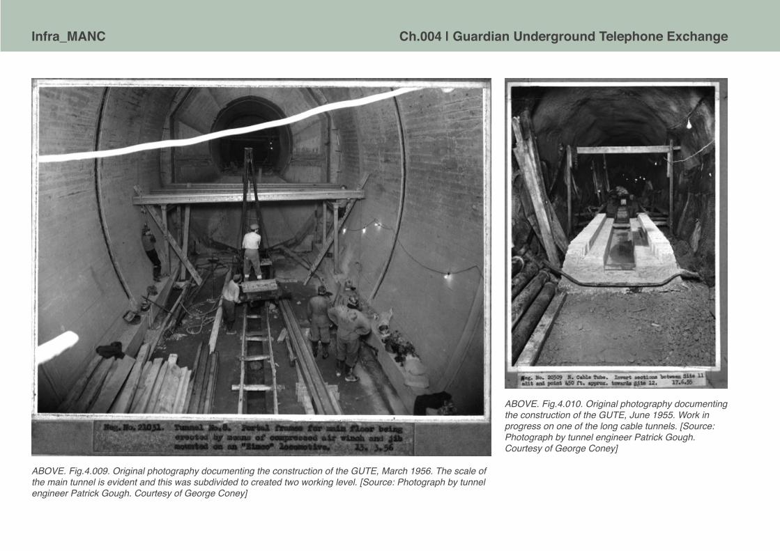
Infra_MANC Ch.004 | Guardian Underground Telephone Exchange
ABOVE. Fig.4.009. Original photography documenting the construction of the GUTE, March 1956. The scale of the main tunnel is evident and this was subdivided to created two working level. [Source: Photograph by tunnel engineer Patrick Gough. Courtesy of George Coney]
ABOVE. Fig.4.010. Original photography documenting the construction of the GUTE, June 1955. Work in progress on one of the long cable tunnels. [Source: Photograph by tunnel engineer Patrick Gough. Courtesy of George Coney]

Ch.004 | Guardian Underground Telephone Exchange Infra_MANC
ABOVE. Fig.4.011. Original photography documenting the construction of the GUTE, June 1955. Another view of work in progress on the cable tunnels. [Source: Photograph by tunnel engineer Patrick Gough. Courtesy of George Coney]
ABOVE Fig.4.012. Original photography documenting the construction of the GUTE, June 1955. View is ongoing work one at the bottom of the access shafts. [Source: Photograph by tunnel engineer Patrick Gough. Courtesy of George Coney]
ABOVE. Fig.4.013. Original photography documenting the construction of the service building at 56 George St., Manchester, November 1960. The ventilation tower is nearly complete. [Source: Photograph by tunnel engineer Patrick Gough. Courtesy of George Coney]
The recently completed Post Office communications tunnels join an existing network, provided in 1956, which extends across the two cities of Manchester and Salford. Cable tunnels run from Ardwick on the south side, pass beneath Deansgate, continue northwards under the River Irwell and westwards across Salford. They connect with a grid of large diameter tunnels under Piccadilly which house the telecommunications apparatus with its associated plant and support systems. The tunnels are basically horse-shoe shaped but vary considerably in size and detail, and as an indication of the scope of the accommodation, there were eight main types of tunnel cross section, each having two, three or four subdivisions. They were lined with plain concrete ranging from 10 to 36in nominal thickness except the ventilation tunnels which were constructed in 7ft diameter cast iron bolted rings running beneath the apparatus tunnels. The whole of the tunnel system lies between 100 and 200ft deep, entirely within Bunter sandstone which was very wet. The cable entry shafts in 12ft diameter bolted cast iron lining were sited on derelict plots near the cities’ existing telephone exchnages. From each shaft ran a short spur 9ft 6in nominal diameter tunnel. Tunnels & Tunnelling, September 1974, p.30
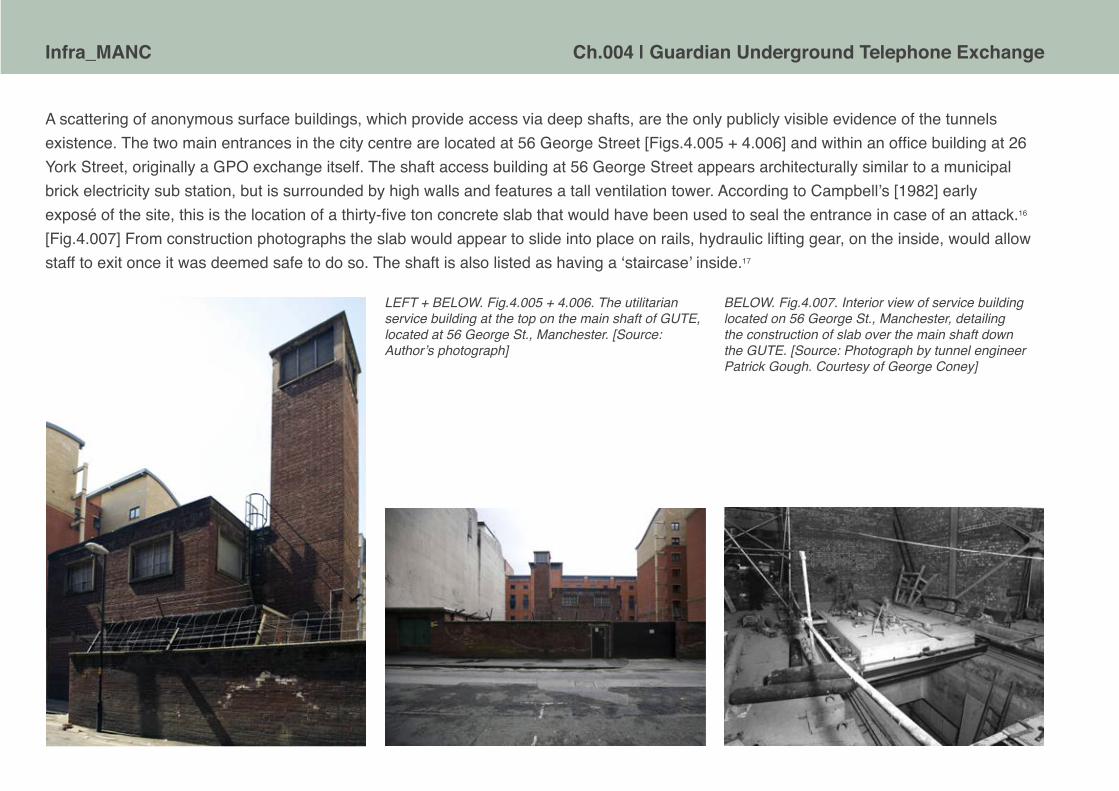
Infra_MANC Ch.004 | Guardian Underground Telephone Exchange
A scattering of anonymous surface buildings, which provide access via deep shafts, are the only publicly visible evidence of the tunnels existence. The two main entrances in the city centre are located at 56 George Street [Figs.4.005 + 4.006] and within an office building at 26 York Street, originally a GPO exchange itself. The shaft access building at 56 George Street appears architecturally similar to a municipal brick electricity sub station, but is surrounded by high walls and features a tall ventilation tower. According to Campbell’s [1982] early exposé of the site, this is the location of a thirty-five ton concrete slab that would have been used to seal the entrance in case of an attack.16 [Fig.4.007] From construction photographs the slab would appear to slide into place on rails, hydraulic lifting gear, on the inside, would allow staff to exit once it was deemed safe to do so. The shaft is also listed as having a ‘staircase’ inside.17
LEFT + BELOW. Fig.4.005 + 4.006. The utilitarian service building at the top on the main shaft of GUTE, located at 56 George St., Manchester. [Source: Author’s photograph]
BELOW. Fig.4.007. Interior view of service building located on 56 George St., Manchester, detailing the construction of slab over the main shaft down the GUTE. [Source: Photograph by tunnel engineer Patrick Gough. Courtesy of George Coney]
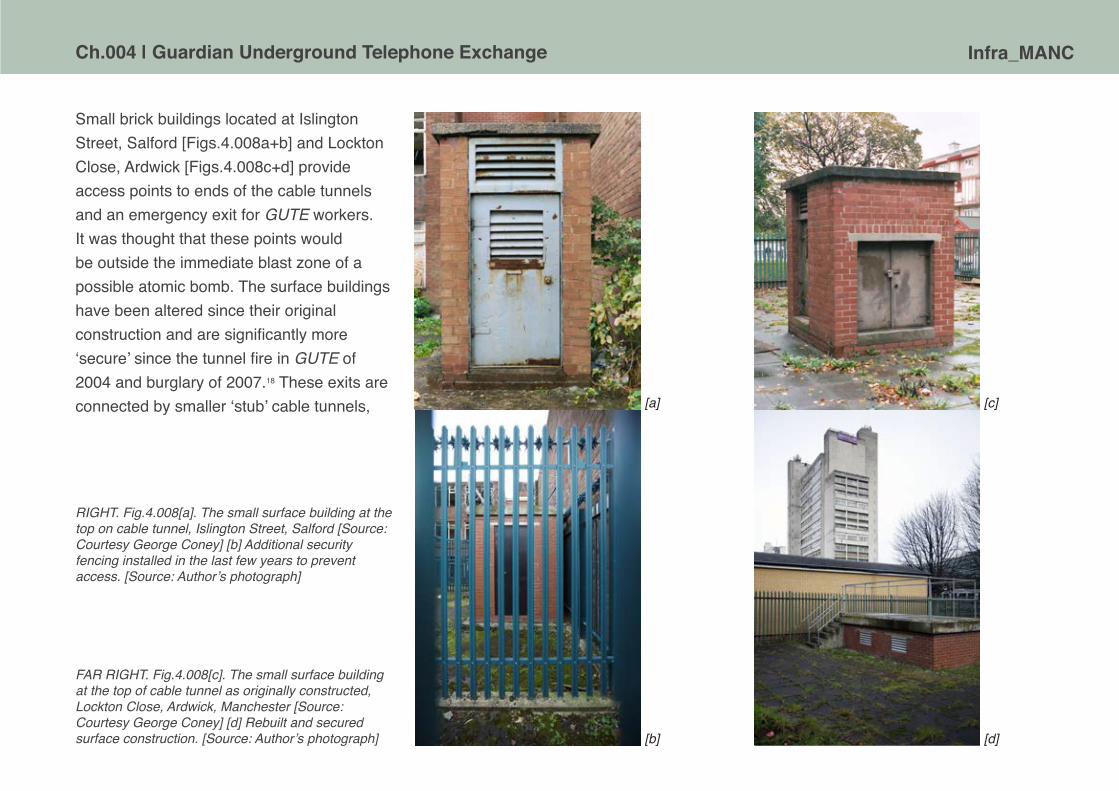
Ch.004 | Guardian Underground Telephone Exchange Infra_MANC
Small brick buildings located at Islington Street, Salford [Figs.4.008a+b] and Lockton Close, Ardwick [Figs.4.008c+d] provide access points to ends of the cable tunnels and an emergency exit for GUTE workers. It was thought that these points would be outside the immediate blast zone of a possible atomic bomb. The surface buildings have been altered since their original construction and are significantly more ‘secure’ since the tunnel fire in GUTE of 2004 and burglary of 2007.18 These exits are connected by smaller ‘stub’ cable tunnels,
RIGHT. Fig.4.008[a]. The small surface building at the top on cable tunnel, Islington Street, Salford [Source: Courtesy George Coney] [b] Additional security fencing installed in the last few years to prevent access. [Source: Author’s photograph]
[a]
[b] [d]
[c]
FAR RIGHT. Fig.4.008[c]. The small surface building at the top of cable tunnel as originally constructed, Lockton Close, Ardwick, Manchester [Source: Courtesy George Coney] [d] Rebuilt and secured surface construction. [Source: Author’s photograph]

Infra_MANC Ch.004 | Guardian Underground Telephone Exchange
also able to accommodate maintenance teams, stemming from the main complex including an offshoot beneath Dial House, another exchange located in Salford. [Fig.4.014]. Several temporary tunnels, now filled in, were used for the removal of rubble and ventilation during construction; Post Office records show that there were seven surface work sites including a prominent shaft and headgear at Piccadilly [Fig.4.015] where the plaza would eventually be built. Despite there only being seven sites on the schedule they are numbered 4,5,6,7 and 11,12,13 which would suggest that there were other sites perhaps discounted during the land assembly and conveyance processes.19 The total number of known physical entry points is six; though there are likely other points of connection between GUTE and the outside world – power, ventilation, sewer and pumping out water seepage, in addition signs in the tunnels themselves refer to shafts, 7, 4 and 12. [Fig.4.016] It is likely that the site numbers were transferred to those allocated to the shafts and thus, Site 5, listed as ‘York St. and George St.’ became shaft 5.
ABOVE. Fig.4.014. Exterior view of Irwell House, extension to Dial House, Salford, 2004. [Source: Author’s photograph]
ABOVE. Fig.4.015. Prominent headgear, located in Piccadilly, needed to winch man and materials up and down the shaft to the GUTE tunnel workings. [Source: Photograph by tunnel engineer Patrick Gough. Courtesy of George Coney]

Ch.004 | Guardian Underground Telephone Exchange Infra_MANC
Rutherford House [Fig.4.017] was constructed in 1967 by the Ministry of Public Buildings and Works, as a telephone exchange, on the corner of George Street and New York Street20. The site is noted in 1957 as having a ‘subway to telephone exchange, plus manhole in shafthead to be superseded by normal PO building’;21 one can assume that this ‘normal’ building is in fact Rutherford House. The name is perhaps a pun on nuclear science; Ernest Rutherford is credited with being the first to ‘split the atom’ and discover protons in a series of experiments in Manchester between 1913 and 1919.22 Rutherford House used to contain British Telecom offices and extensive telecommunications equipment. It is now a commercial office building, following a refurbishment by Roger Stephenson Architects in 2008. It is often confused with providing a pedestrian entrance to the GUTE, whilst this may not be the case, evidence of physical connections to the underground exchange can be seen on the façade of the building where maintained signage indicates the position of service risers. [Fig.4.018]
ABOVE. Fig.4.017. Exterior view of Rutherford House, Manchester, 2006. [Source: Courtesy of Roger Stephenson Architects]
ABOVE. Fig.4.016. Interior signage. [Source: Authors video still. Courtesy of hogshawrabbits]
BELOW. Fig.4.018. Detail of service ducts on Rutherford House down to GUTE, 2011 [Source: Author’s photograph]
Infra_MANC Ch.004 | Guardian Underground Telephone Exchange
Descriptions of the main working areas of the exchange tunnel are few and far between, Michael Duffy, a Manchester Evening News reporter paid a visit in 1983 in an attempt to dispel some of the mythology surrounding the installation. Duffy’s article entitled ‘The truth about Manchester’s nuclear bunker’23 is a good example of a first hand account of the GUTE and also enduring media interest in exposing ‘secret sites’. It should also be noted that the article was published six years before the fall of the Berlin Wall and was written to engage readers of the newspaper. Duffy explains rumours claiming the tunnels were a nuclear shelter for the ‘chosen few’ during an attack, were reaching such a magnitude that the City Council had requested of Greater Manchester Council [GMC] that the tunnels be opened as an emergency nuclear centre. As Duffy claimed: ‘…the Labour group on the GMC ruled that its leaders would refuse places offered to them in the Piccadilly Shelter’.24 Although the GUTE was vulnerable to the nuclear threat and could not realistically be used as a civilian shelter, this appears to demonstrate a time when even the rumour of such was liable to cause tensions between the governing bodies and the general public. Duffy’s account was quick to challenge said rumours, dispelling them, describing the tunnels as ‘an outdated product of the Cold War’, with the journalist further explaining that the GUTE was not equipped to serve such a governmental function and was actually at risk of becoming obsolete for even basic telecommunications operations due to advances in digital exchange technology. A subsequent visit by the Manchester Civic Society [1996] revealed more details concerning the working lives of the GPO personnel. Not long after this archaeologists and a professional photographer from English Heritage also conducted a photographic recording exercise for the National Monuments Record as part of their broader study of Cold War heritage sites.25 This pattern of ‘opening-up’ the GUTE, with authorised access by journalists, urban conservationists and official archaeologists by the end of the 1990s would seem to indicate that the exchange was no long serving a significant role for BT, or anyone else, at that time and perhaps that the corporation was considering relinquishing its control of this piece of aging infrastructure. [It has subsequently tried to sell the Kingsway tunnels in London.]
ABOVE. Fig.4.019. View of the ‘pipe’ model built to show the configuration of the core GUTE tunnels. Model was held in the GUTE itself. [Source: Author’s video still. Courtesy of hogshawrabbits]

Ch.004 | Guardian Underground Telephone Exchange Infra_MANC
Mapping out the GUTE Underground and within the core tunnel complex there are two main levels connected at various points by stairs. Certain sections of the tunnels are of sufficient diameter to contain upper and lower levels, though smaller gauge tunnels also connect the upper and lower sections and the idea of two levels simply stacked on top of one another does not quite represent the true configuration of the subterranean spaces. The photograph of the tunnel ‘pipe’ model [Fig.4.019] details how some of these connections are configured. On the main level of the exchange, in the largest and longest tunnel [known as A.T.8], GPO engineers maintained the analogue equipment formed from repeated racks of uniselectors [Fig.4.020] and to provide standard telephone communications:
The M.D.F. comprises 45 verticals, and an unusual feature of the frame is the use of connexion strips in place of Protectors H.C. and Test where the circuits are wholly underground; this should reduce fault liability. The switching equipment, consisting of some 219 racks is arranged symmetrically around an I.D.F of 67 verticals, reducing cable runs to a minimum. All cable and wire is p.v.c insulated. … The trunking scheme employs first, second and third switching stages, all selectors being of the motor-uniselector group-selector type.26
LEFT. Fig.4.018. View of racks of telecommunications equipments in the main Apparatus Tunnel 8 in 1996. [Source: Author’s video still. Courtesy of hogshawrabbits]

Infra_MANC Ch.004 | Guardian Underground Telephone Exchange
Fig.4019. The layout of core GUTE tunnels in relation to surface streets. The position of the pedestrian link to York House is uncertain. [Source: Author’s map. The compilation draws upon research by Nicholas Mitchell and the plan provided in Cocroft, W.D., Thomas, R.J.C., and Barnwell, P.S. [2003] Cold War: Building for Nuclear Confrontation 1946-1989 [Swindon: English Heritage], p164.

Ch.004 | Guardian Underground Telephone Exchange Infra_MANC
Fig.4.020. Set of original photography documenting the completion of physical construction and the equipment fit out in GUTE, 1958. [Source: Photographs by tunnel engineer Patrick Gough. Courtesy of George Coney]

Infra_MANC Ch.004 | Guardian Underground Telephone Exchange
[a]
[b]
[c]
[d]
[e]
[f]

Ch.004 | Guardian Underground Telephone Exchange Infra_MANC
In the next chamber the familiar perforated vertical face of the main distribution frame, the icon of mid-century communications, was located [Fig.4.021a]. Also on this level were the two Crossley generators, Jane and Marilyn, apparently named after Russell and Monroe [Figs.4.021b+c]. A third smaller, ‘auto-start’ electrical generator was also present.
The lower level tunnel, in two sections perpendicular to one another, as well as housing the emergency batteries, was largely designed for the use of personnel. Images and descriptions of rooms on the lower level serve as a reminder of the exchange’s possible uses during nuclear war. The rooms were a series of chambers off a narrow corridor. One of these chambers was a kind of ‘war room’, described by Duffy [1983] to be small and to contain a wall-sized map of Britain.27 Warrender [2009] claims that this room also housed a safe containing instructions on how to operate the GUTE during an emergency.28 Other spaces included a first aid room [Fig.4.022], dining room, maintenance office, kitchen, male and female toilets and a cloakroom. Food supplies are reported to have been refreshed around every sixteen months. A piano, pool table and a fish tank could be found in the recreation room [Fig.4.023a] and the piscine theme continued in the canteen, where Duffy observed an aquarium of tropical fish on his visit in 1983. Mirrors on the walls [Fig.4.023b] are said to have been used to enhance the lighting and sense of space and emergency beds were also stored in the lower tunnel.
FACING PAGE. LEFT. Fig.4.021. Views of GUTE taken from an 1 hour video ‘tour’ conducted in 1996. [a] View of the test desk in AT8. [b] + [c] Close-up views of the diesel back-up generators in AT5. [d] View along AT5 housing the electrical generators. [e] Lower level corridor in AT8. [f] Stairwell in the middle of AT8 down to the lower level staff accommodation rooms. [Source: Author’s video stills. Courtesy of hogshawrabbits]
ABOVE. Fig.4.022. View of first aid room, in lower level of AT8, 1996. [Source: Author’s video still. Courtesy of hogshawrabbits]

Infra_MANC Ch.004 | Guardian Underground Telephone Exchange
For fresh water supply there was an artesian well within the complex, it’s exact location is difficult to ascertain from publicly available information, but it is recorded in the original Post Office records as being beneath ‘Alexander Drew & Sons, 33 George St.’ and that the ‘surface land’ was ‘privately owned’ and that the ‘well [had been] sunk from tunnel level’.29 [Fig.4.019 indicates the likely location, marked by ‘AW’] The manner in which sewage and other foul outlets connected into the wider infrastructure of the city is not known.
The entire complex was distinctly functional not simply in the provision of the necessary equipment, but in the applied colour palette and material finishes of muted military beiges and greens, typical of 1950s Ministry of Works. The white light of the fluorescents seen in photographs and videos has a stark quality befitting of the utilitarian nature of the spaces, but not very comforting or forgiving. As the staff levels were minimised in later years of operation it must have been particularly eerie to be the sole occupant of the tunnels.
ABOVE. Fig.4.023. Views of [a] recreation room and [b] canteen room, both in lower level of AT8, 1996. [Source: Author’s video stills. Courtesy of hogshawrabbits]
In the warm summer months we were able to keep the temperature under control by chilling the air with a fridge plant as in was drawn into the complex and then again in the wintertime it was nice to be able to come in out of the cold due to the way in which the air could be recycled within the complex. There were three groups of engineers involved; an Automatic Trunk Switching staff of whom I was a member; a Trunk Test and Repeater Station staff who we worked closely with; and a Power Group who kept the place running for us. I believe we all got on well for the most part – otherwise I would not have stayed down in the tunnel for 28 years!!. There was a fully equipped workshop and many of the Power Engineers were very skilled men. If you needed expert advice on any D.I.Y. project, whether welding; plumbing; lathe skills; or any electrical matter, help and advice was always at hand. In my view it was a happy place in which to work.
Malcolm Graham, Technical Officer, Level 1 Manager, GUTE, 1959-1988

Ch.004 | Guardian Underground Telephone Exchange Infra_MANC
Although designed to withstand an atomic bomb blast, the GUTE was exclusively for the protection of communications equipment and the operators required for it to function, rather than to provide an anti-nuclear bunker and public refuge. Now demolished, a Regional War Room was located in south Manchester, near to Alexandra Hospital, Cheadle.30 [see Fig.4.024] This was designed to protect a group of ‘specialists’ chosen to govern the region in the event of an attack. For the purposes of Civil Defence Britain was divided up into regions or zones each containing a Regional Government Head Quarters31 [RGHQ] in the hope of providing a semblance of local control once Westminster had been obliterated. Although the bunker at Cheadle contained important operational staff, the RGHQ for the North West [home defence region 10.1–10.2] was located at Hack Green, Cheshire [Fig.4.025].32 Other regional defence sites included the Anti-Aircraft Operations Rooms [AAOR] at Worsley and Frodsham [Fig.4.026], both partially buried, bunker-like, concrete structures.
ABOVE. Fig.4.024. Former Regional War Room in Cheadle, Manchester, 2002. [Source: Courtesy of Nick Catford]
ABOVE. Fig.4.026. Views of AAOR bunker at Frodsham, 2006. [Source: Author’s photograph]
LEFT. Fig.4.025. Room at Hack Green, former NW RGHQ, now a museum [Source: Author’s photograph]

Infra_MANC Ch.004 | Guardian Underground Telephone Exchange
INTERIOR RECORD
Over the following pages are presented a selection of the photographs taken by Tony Perry [July 1998] as part of an English Heritage photographic study of the GUTE.
The full set of published images from this study can be browsed on <http://viewfinder.english-heritage.org.uk/>

Ch.004 | Guardian Underground Telephone Exchange Infra_MANC
Ref. No AA98/02416.
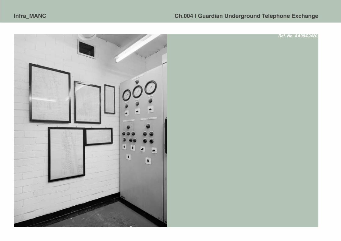
Infra_MANC Ch.004 | Guardian Underground Telephone Exchange
Ref. No AA98/02420.

Ch.004 | Guardian Underground Telephone Exchange Infra_MANC
Ref. No AA98/02424.
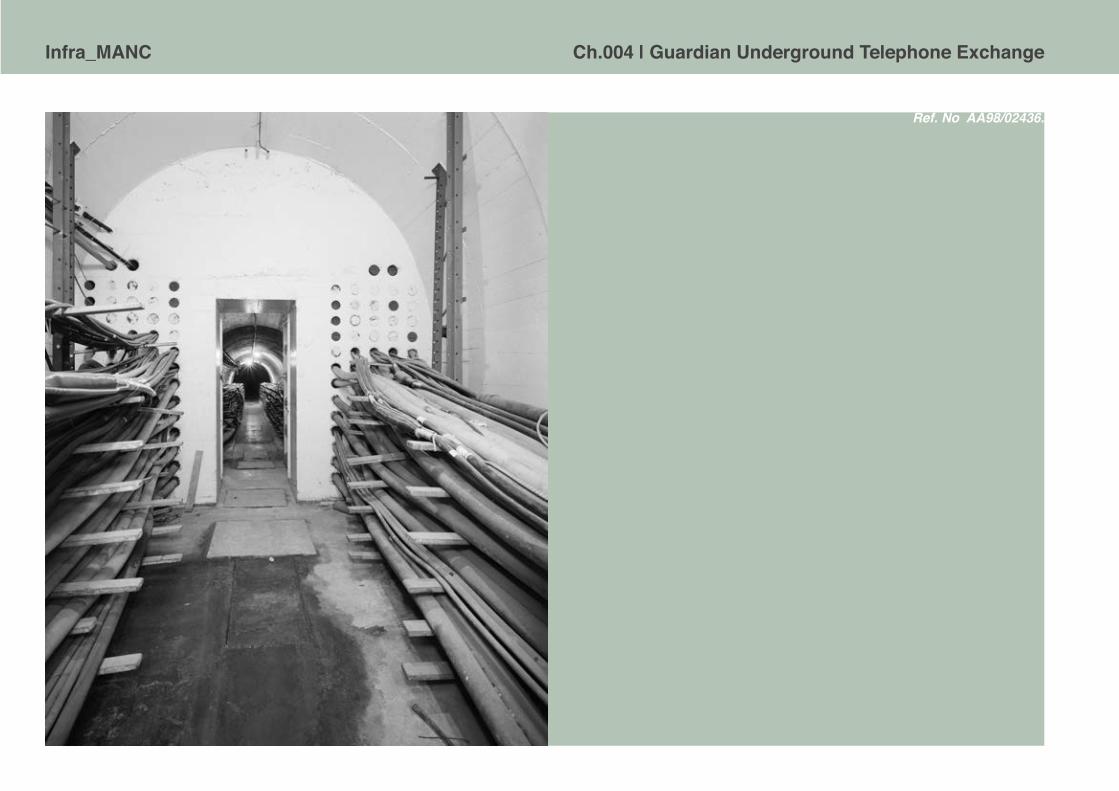
Infra_MANC Ch.004 | Guardian Underground Telephone Exchange
Ref. No AA98/02436.

Ch.004 | Guardian Underground Telephone Exchange Infra_MANC
Ref. No AA98/02422.
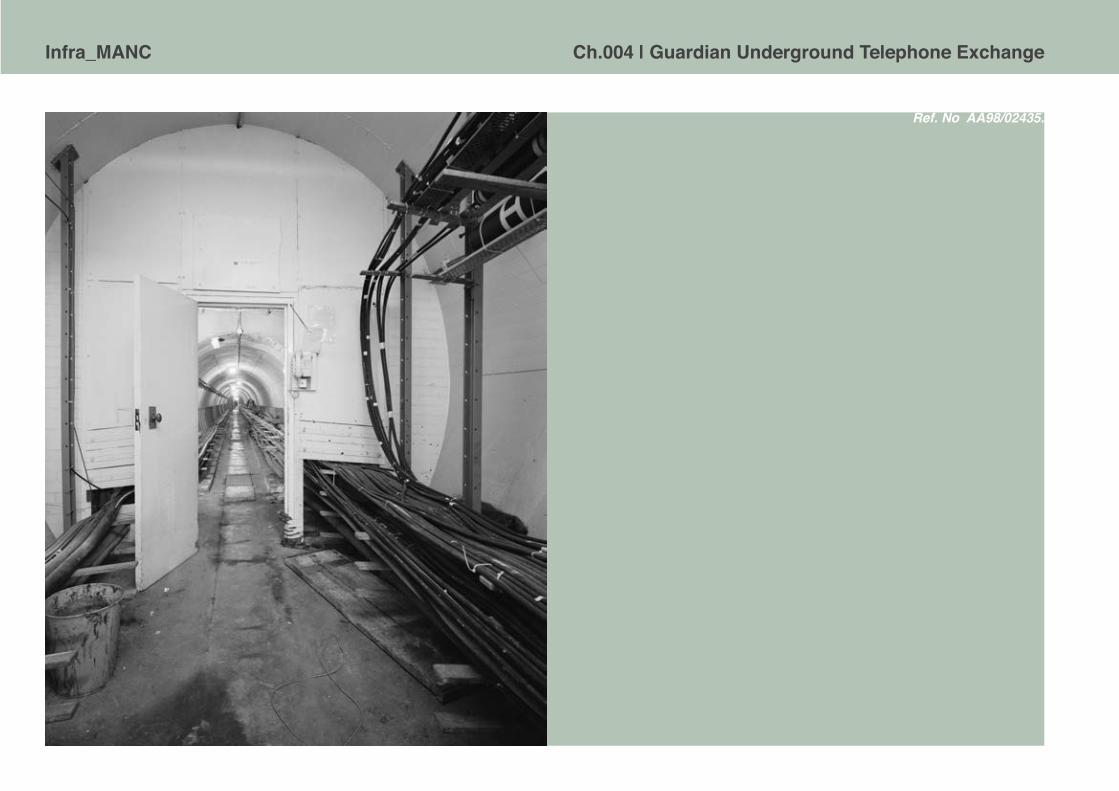
Infra_MANC Ch.004 | Guardian Underground Telephone Exchange
Ref. No AA98/02435.
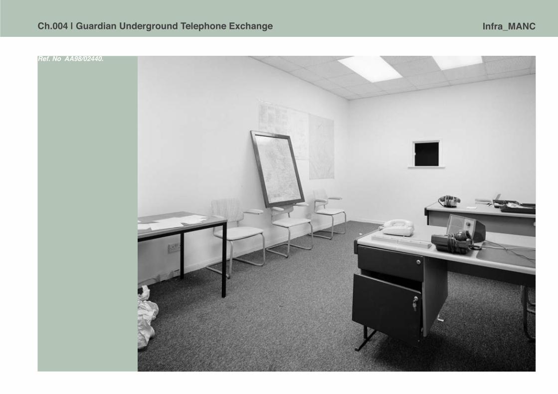
Ch.004 | Guardian Underground Telephone Exchange Infra_MANC
Ref. No AA98/02440.
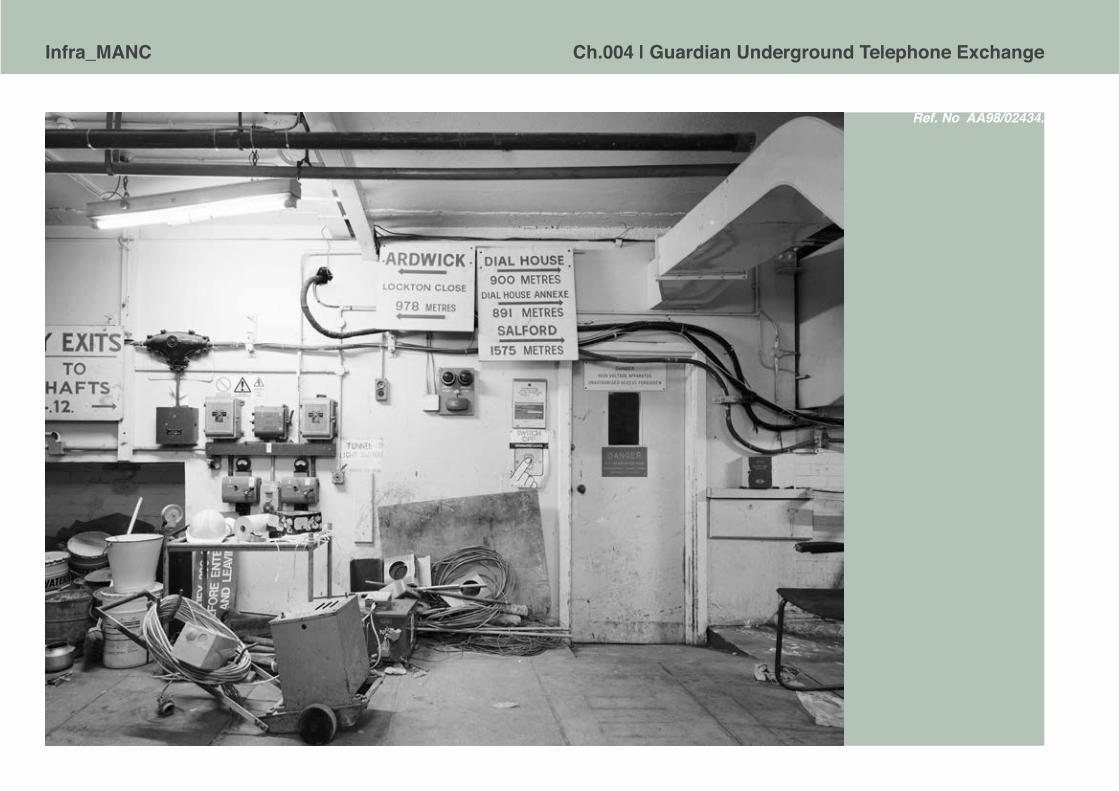
Infra_MANC Ch.004 | Guardian Underground Telephone Exchange
Ref. No AA98/02434.

Ch.004 | Guardian Underground Telephone Exchange Infra_MANC
Ref. No AA98/02423.

Infra_MANC Ch.004 | Guardian Underground Telephone Exchange
The cold front The popular conception that Manchester as a major population centre would have been a strategic target of nuclear attack was, in some senses, reinforced by the construction of the GUTE. However, simply by considering the types of functional space it contained, it is clear that this was not conceived as a shelter to provide any form of public provision in relation to civil defence. In contrast, in the USA a considerable amount of attention was lavished on giving the public the impression that they were being protected,33 signs at many locations across major American cities show buildings were adapted or allocated for such [Fig.4.028]. Evans [1982] explains that a major reason for the lack of similar constructions in the UK was down to cost, with Britain enduring a shattered economy and a decade or more of severe post-war austerity. As an illustration of this, a letter from the Home Office to MP Mr Nicholas Scott reads, ‘the estimated cost of providing family concrete underground shelters to only 10 million homes, based on a design of which we have some knowledge, is between £60,000
ABOVE. Fig.4.028. Nuclear fallout shelter sign, New York, 2008 [Source: Author’s photograph.]

Ch.004 | Guardian Underground Telephone Exchange Infra_MANC
million and £80,000 million’.34 Moreover, targets for an attack could only be speculated upon and the real effects were uncertain. Evans [1982], for example, quotes Air Marshal Sir Leslie Mayor, RAF [retired], Principle of the Home Defence College, at a NATO Civil defence training seminar in 1977, ‘[t]he attack will be aimed at putting us quickly out of the reckoning by disabling the country militarily, politically and economically’.35 He went onto assert that the main targets would be knocked out, unable to administer self-aid. These targets would have to be discounted until, less damaged regions could recover and then come to their aid. If, as was likely, Manchester was considered a prime target, this could explain the reason for no visible effort at providing public shelter capability. The ability of the GUTE to remain functional during an attack would be vital in maintaining national communications; its purpose was not about the protection of the city populous or regional resilience. Evans [1982] details the civil defence strategy at the time:
In the absence of a shelter for the general populace, the accent has been put on retaining the means of generation. That implied a need for the survival of government. Thus the result has been on the protection of government, a policy that critics now compare with the lack of protection of the ordinary populace. ‘Elitist’, is the charge levelled at Britain’s present Civil Defence policy.36

Infra_MANC Ch.004 | Guardian Underground Telephone Exchange
Instead of shelter provision and mass population evacuation, the alternative civil defence strategy was for the public to ‘stay put’ and try to survive in their own homes. This advice is most evident in the civil defence guides Protect and Survive, amongst other civil defence handbooks, from the Cold War era. The Protect and Survive pamphlet was published in 1980 with the intention to ‘educate’ and advise the public on the prospect of nuclear confrontation. They were part propaganda and partly the typical paternalistic politics of the British State to its subjects.
If nuclear weapons are used on a large scale, those of us living in the country areas might be exposed to as great a risk as those in the towns. The radioactive dust, falling where the wind blows it, will bring the most widespread dangers of all. No part of the United Kingdom can be considered safe from both the direct effects of the weapons and the resultant fall-out.37
Advice found in Civil Defence Handbook No. 10 [1963] directs householders to construct a fallout shelter or ‘core’ within their own house. The ideal location for such a makeshift shelter is proposed as a room on the ground floor of the house, with as few outside facing walls as possible. It was advised the inner ‘core’ should be a lean-to structure, made from doors, or even to use the cupboard under the stairs. The walls of the ‘core’ could be made thicker by the stacking of furniture and other items found around the house. [Fig.4.029] Occupants were then to remain inside their shelters for up to fourteen days after a blast, in order to survive the worst effects of radioactive fallout.
The naivety of such advice, the general public’s misunderstanding of savage reality nuclear war conditions and faith in such a plan was famously epitomised in the 1986 film When the Wind Blows.38 This animated film was made at the height of the Reagan era confrontation with the USSR, and in a grainy, gloomy tone, follows a middle aged couple, through the process of constructing a shelter following government guidelines, surviving the actual attack
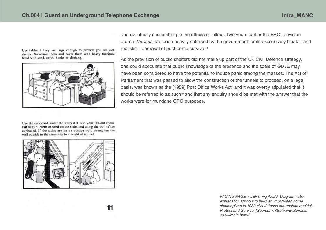
Ch.004 | Guardian Underground Telephone Exchange Infra_MANC
and eventually succumbing to the effects of fallout. Two years earlier the BBC television drama Threads had been heavily criticised by the government for its excessively bleak – and realistic – portrayal of post-bomb survival.39
As the provision of public shelters did not make up part of the UK Civil Defence strategy, one could speculate that public knowledge of the presence and the scale of GUTE may have been considered to have the potential to induce panic among the masses. The Act of Parliament that was passed to allow the construction of the tunnels to proceed, on a legal basis, was known as the [1959] Post Office Works Act, and it was overtly stipulated that it should be referred to as such40 and that any enquiry should be met with the answer that the works were for mundane GPO purposes.
FACING PAGE + LEFT. Fig.4.029. Diagrammatic explanation for how to build an improvised home shelter given in 1980 civil defence information booklet, Protect and Survive. [Source: <http://www.atomica.co.uk/main.htm>]

Infra_MANC Ch.004 | Guardian Underground Telephone Exchange
The intrigue of infrastructure Redundant of its original function, and with risks of nuclear war receding into history, the GUTE could be perceived as merely a strange subterranean space, an architectural relic from the Cold War. This perception is not true, as the tunnels continue to operate as a piece of vital infrastructure, allowing the information-age city to function. The underground network serves as an existing, secure space to install fibre-optic cables without forming new, deep and expensive excavations. This process allows the city to progress with technological advances with minimal disruption and greatly reduced financial costs. ICT infrastructure is integral to the smooth function of cities: such systems facilitate everyday activities and enable cities to operate on a global level serving to draw commercial validity to an urban area. Graham [2010] articulates the deep importance of infrastructure to contemporary city life:
By sustaining the flows of water, waste, energy, information, people, commodities, and signs, massive complexes of contemporary urban infrastructure are the embodiment of enlightenment dreams of the social control of nature through advances in technology and science. They are the prerequisite of any notion of modern civilisation.41
Aside from the inherent physical permanence of the GUTE,42 and its security from its subterranean position, its function as a piece of infrastructure equates to cultural permanence through a widespread lack of technological comprehension [or even awareness] by the general public. Infrastructure, almost by definition, is about being invisible and ignored. Taking such underground systems for granted, assuming that such utilities are always ‘on’ and working, appropriates an image of permanence and stability. In contrast to this image of permanence and stability, systems of infrastructure are delicately balanced, prone to failure, highlighting the vulnerability of urban processes that rely heavily upon them. Most infrastructures also require continuous monitoring [as failures have serious consequences] and careful maintenance by a skilled engineering labour force.
BELOW. Fig.4.030. Evidence of effort required to deal with the fire in the GUTE in March 2004. [Source: Courtesy of George Coney]
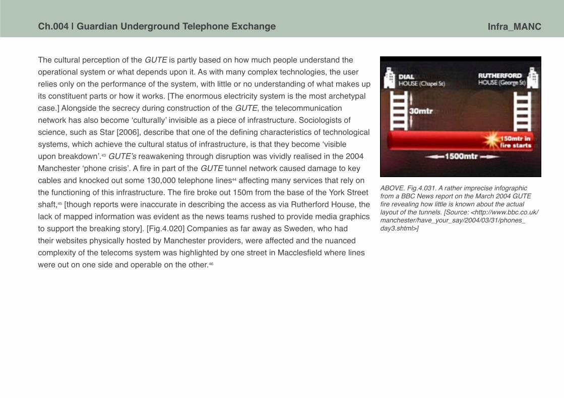
Ch.004 | Guardian Underground Telephone Exchange Infra_MANC
The cultural perception of the GUTE is partly based on how much people understand the operational system or what depends upon it. As with many complex technologies, the user relies only on the performance of the system, with little or no understanding of what makes up its constituent parts or how it works. [The enormous electricity system is the most archetypal case.] Alongside the secrecy during construction of the GUTE, the telecommunication network has also become ‘culturally’ invisible as a piece of infrastructure. Sociologists of science, such as Star [2006], describe that one of the defining characteristics of technological systems, which achieve the cultural status of infrastructure, is that they become ‘visible upon breakdown’.43 GUTE’s reawakening through disruption was vividly realised in the 2004 Manchester ‘phone crisis’. A fire in part of the GUTE tunnel network caused damage to key cables and knocked out some 130,000 telephone lines44 affecting many services that rely on the functioning of this infrastructure. The fire broke out 150m from the base of the York Street shaft,45 [though reports were inaccurate in describing the access as via Rutherford House, the lack of mapped information was evident as the news teams rushed to provide media graphics to support the breaking story]. [Fig.4.020] Companies as far away as Sweden, who had their websites physically hosted by Manchester providers, were affected and the nuanced complexity of the telecoms system was highlighted by one street in Macclesfield where lines were out on one side and operable on the other.46
ABOVE. Fig.4.031. A rather imprecise infographic from a BBC News report on the March 2004 GUTE fire revealing how little is known about the actual layout of the tunnels. [Source: <http://www.bbc.co.uk/manchester/have_your_say/2004/03/31/phones_day3.shtml>]

Infra_MANC Ch.004 | Guardian Underground Telephone Exchange
Failure of this system cost Manchester businesses approximately £4.5million a day,47 highlighting the technical relevance of the GUTE in the contemporary city. Graham [2010] explains the vulnerability that originates from the reliance of infrastructural networks on other uncontrollable networks resulting in almost countless numbers of ways in which failures might cascade.48 In the case of the Manchester ‘phone crisis’: parts of the emergency services were unable to take 999 calls or maintain communication with staff resulting in the deployment of extra units of police across the region. Many businesses struggled to operate without telecommunications and banks in the city were unable to process transactions, affecting wider financial systems. Moreover, this was not the first fire recorded in the tunnels, in 1969, shortly after the lifting of secrecy, workmen jointing cables accidentally set some petrol cans alight and firemen ‘walked for more than a mile’ to extinguish the blaze.49
The depth of reliance on infrastructure to the daily unfolding of contemporary urban life in industrialised countries and the disruption evident upon failure supposedly makes such networks ideal targets for terrorist activity. A pervasive fear of a ‘securocratic’50 war has led to everyday failures of infrastructure systems to initially being interpreted as terrorism related. This theory manifested itself on 21 July 2005 when the GUTE was broken into on the same day as the failed bombing attempts on London. Police treated the break-in as a terrorist attack and deployed a full forensic unit to the tunnels.51 The team found a discarded cigarette butt that they were able to analyse and, using DNA evidence, secure a conviction for theft against a 29 year old Salford man. Viewing the GUTE as a possible terrorist target likely explains part of the motive for the significantly improved security features around the tunnel exits. Yet there is little or no evidence that terrorists have taken an active interest in targeting infrastructure – Hollywood movie plot scenarios and CIA security discourse aside.
ABOVE. Fig.4.032. A trophy photograph of an unknown ‘urban explorer’ who apparently penetrated the GUTE in days of weaker physical security in the early C21. [Source: Courtesy of George Coney]

Ch.004 | Guardian Underground Telephone Exchange Infra_MANC
Tunnel visions While Manchester Evening News journalist Duffy [1983] mentions the location and physical design of the GUTE was still important for communications in the city and despite his efforts to dispel the growing folklore focused on nature of the tunnels: ‘The bunker myth is now wearing a bit thin on the 20 strong band of engineers who man the exchange round the clock’,52 speculation still persists and urban legends proliferate. Despite the real mundanity of these dank tunnels, they have, over the subsequent decades, and in an era of X-File conspiracies and government cover-ups, acquired a certain mythology particularly amongst a specialist subcultures concerned with infiltrating hidden and normally inaccessible spaces of the city. The vision of this activist subculture, broadly known as ‘Urban Explorers’, revolves around inbred fascination with ‘going where you’re not supposed to go’, mixed with a degree of adrenalin from the real risks of physical harm and potential legal consequences associated with accessing spaces like the GUTE. As well as real world escapades this group expound their actions in online forums and photographic essays. There are individuals who claim to have made limited, but nonetheless unsanctioned, entry into the GUTE and have produced photographs to corroborate their account.53 Other discourse includes one-upmanship concerning who has the most ‘elite’ knowledge about access, security levels or is able to present new source material for collective research purposes. This created version of the tunnels not only perceives them as a holy grail of the subculture, it is also able to sustain a form of myth attached to a mundane piece of fifty year old infrastructure. Maybe the only way to finally put them to rest is to open a visitor centre.54 But of course, there may be even deeper unnamed, undisclosed bunkers under Manchester…
LEFT. Fig.4.033. Part of an account of a visit to the GUTE made by Moose73. Posted in 2008 on ‘28dayslater - The UK UE Urbex Urban Exploration Forums’. [Source: Author’s screenshot]
Infra_MANC Ch.004 | Guardian Underground Telephone Exchange
1 This text draws, in parts, upon Permanent Structure Redundant Programme: An enquiry into how the perception of the ‘Guardian Underground Telephone Exchange’. An unpublished dissertation submitted to the Manchester School of Architecture for the degree of Bachelor of Architecture, by Nicholas J. Mitchell 2010. We are grateful to Nicholas Mitchell for permission to use his work.
2 For a comprehensive survey of structures in the UK, see Cocroft, W.D., Thomas, R.J.C., and Barnwell, P.S. [2003] Cold War: Building for Nuclear Confrontation 1946-1989 [Swindon: English Heritage].
3 For reviews of the architectural form and the some of social meanings of such bunker spaces, see Vanderbilt, T. [2002] Survival City: Adventures Among the Ruins of Atomic America [New York: Princeton Architectural Press]; Catford, N. [2010] Cold War Bunkers [Bradford-on-Avon: Folly Books]; Beck J. [2011] ‘Concrete ambivalence: Inside the bunker complex’, Cultural Politics, 7[1]: pp.79- 102.
4 See Cocroft et al. [2003] Op cit., pp.84-123; and also <http://www.thetimechamber.co.uk/Sites/Civil/Rotor.php>, [Accessed 5 January 2012].
5 The other two sites were in London and Birmingham; see Laurie, P. [1970] Beneath the City Streets [London: Panther].
6 McCamley, N.J. [2002] Cold War Secret Nuclear Bunkers [Barnsley: Pen & Sword], p.230.
7 Laurie [1970] Op. cit. Angwin, S. [1947] ‘untitled’, Journal of the Institution of Electrical Engineers, 94[3], p.7.
8 See Catford [2010] Op .cit., pp. 155-159. The cable route south from the GUTE was likely to have gone to the Stockport PR1 built at Hempshaw Lane.
9 Laurie [1970] Op. cit., p.149.
10 Virilio, P. and Collins, G.F. [trans.] [1994] Bunker Archaeology [New York: Princeton Architectural Press].
11 This might be read as part of the spectacle secrecy that has become evermore apparent in the past decade around military and state security, cf. Perkins, C. and Dodge, M. [2009] ‘Satellite imagery and the spectacle of secret spaces’, Geoforum, 40[4]: pp.546-60.
12 Subterranea Britannica, <www.subbrit.org.uk>, is a site and organisation dedicated to the histories of underground and military installations. Its informative page on the GUTE has been replaced by a link to a blog entry by Mancubist, which is full of speculative commentary about the nature of the site and in many respects only serves to reinforce the mythology. Other sites have been ‘relocated’ and are not retrievable using popular Internet search engines.
13 Ruddick, G. [2009] ‘Kingsway Tunnels: See inside one of London’s most unusual property [sic.]’ in The Telegraph, 23 January. ‘Kingsway, 100ft below the City of London, has enjoyed a colourful 60- year history and is now for sale after its owner, BT, instructed agents to find a buyer.’ <http://www.telegraph.co.uk/finance/4324339/Kingsway-Tunnels-See-inside-one-of-Londons-most-unusual-property. html> [Accessed 19 January 2012]. There is also a promotional style Sky News report on the sale of Kingsway, October 2008, <http://www.youtube.com/watch?v=dmSblwFurbI>.
14 Cocroft et al. [2003] Op. cit., p.220.
15 Comments by Mr. Stonehouse, Postmaster-General in House of Commons debate 21 October 1968, <http://hansard.millbanksystems.com/written_answers/1968/oct/21/underground-exchanges>.
16 Campbell, D. [1982] War Plan UK: The Truth About Civil Defence in Britain [London: Burnett].
17 ‘Schedule I. Scheme 567a Shafts and Shaftheads to Deep Level Tunnels’ marked kk.6.5.57 [Source: BT Archives, ref. POST 122/1049-1051].
18 See later in this chapter for more detailed account of this incident.
19 ‘Schedule I. Scheme 567a Shafts and Shaftheads to Deep Level Tunnels’ marked kk.6.5.57 [Source: BT Archives, ref. POST 122/1049-1051].
20 Canniffe, E. and Jefferies, T. [1999] Manchester Architecture Guide [Manchester: Faculty of Art and Design, Manchester Metropolitan University], p.95.
21 ‘Schedule I. Scheme 567a Shafts and Shaftheads to Deep Level Tunnels’ marked kk.6.5.57 [Source: BT Archives, ref. POST 122/1049-1051].

Ch.004 | Guardian Underground Telephone Exchange Infra_MANC
22 ‘Ernest Rutherford – Biography’, Nobelprize.org, <http://www.nobelprize.org/nobel_prizes/chemistry/laureates/1908/rutherford-bio.html> [Accessed 23 January 2012].
23 Duffy, M. [1983] ‘The truth about Manchester’s nuclear bunker’, Manchester Evening News, 22 March 1983, pp.32-33.
24 Duffy, M. [1983] ‘Ready for the ultimate horror’, Manchester Evening News, 8 April 1983, p.14
25 Wayne Cocroft, pers. comms., 23 January 2012. A small collection of black and white photographs from this study of GUTE, taken by Tony Perry in July 1998, are publicly available from English Heritage, currently accessible via their ViewFinder service, <http://viewfinder.english-heritage.org.uk/>.
26 ‘Manchester trunk mechanisation’, Post Office Electrical Engineers Journal, April 1959 (Vol. 52), p.77.
27 Duffy, M. [1983] ‘The truth about Manchester’s nuclear bunker’, Manchester Evening News, 22 March 1983, pp.32-33.
28 Warrender, K. [2009] Below Manchester [Timperley, Cheshire: Willow Publishing].
29 ‘Schedule I. Scheme 567a Shafts and Shaftheads to Deep Level Tunnels’ marked kk.6.5.57 [Source: BT Archives, ref. POST 122/1049-1051].
30 See Subterranea Britannica, ‘Site Records. Site Name: Cheadle - Manchester Regional War Room/Greater Manchester County Main Control’, <http://www.subbrit.org.uk/rsg/sites/c/cheadle/index.html> [Accessed 23 January 2012].
31 Cocroft et al. [2002] Op cit., p.202.
32 Now open to the public as a museum of the Cold War, <http://www.hackgreen.co.uk>.
33 ‘In response to the warming up of the Cold War, the [US] Federal Government launched the Community Fallout Shelter Program. Under the program, a survey was done in cities across the country in which appropriate structures were designated as shelters, with the federal government providing food, sanitation, medical and radiological detection supplies. The food was to last two weeks. The shelters were not primarily intended to protect against the explosion of a nuclear bomb itself, but rather against the ensuing radioactivity, which would decrease with time.’ Churney, D. [2008] ‘FALLOUT FEVER: Civil Defense shelters dotted area cities during the Cold War’, <http://mywebtimes.com/archives/ottawa/display.php?id=366305> [Accessed 5 January 2012].
34 Evans, P. [1982] ‘The UK front’ In: The Royal United Services Institute for Defence Studies. Nuclear attack civil defence: aspects of civil defence in the nuclear age: a symposium [Oxford: Brassey], pp.169-192.
35 Evans [1982] Op cit., p.174.
36 Evans [1982] Op cit., p175.
37 Home Office [1980] Protect and Survive [London: HMSO], p.1.
38 Murakami, J.T. [Dir.] Briggs, R. [Auth.] [1986] When the Wind Blows [Meltdown Productions, Film Four].
39 It was self-censored by the BBC following the criticism and not shown again on British television for nearly another twenty years.
40 Post Office Works Act, Ch. 43, Clause 7. 1959. [Source: BT Archives, ref. POST 122/1049-1051].
41 Graham, S. [2010] Disrupted Cities: When Infrastructure Fails [London: Routledge] p.4.
42 Although the tunnels may well have exceeded their operationally design lifespan.
43 Star, S. and Bowker, G. [2006] ‘How to infrastructure’ In: Lievrouw, L.A. and Livingstone, S. [eds] Handbook of New Media: Social shaping and social consequences of ICTS [London: SAGE], p.231.

Infra_MANC Ch.004 | Guardian Underground Telephone Exchange
44 <http://news.bbc.co.uk/1/hi/england/manchester/3577799.stm> [Accessed 12 January 2012].
45 <http://www.bbc.co.uk/manchester/have_your_say/2004/03/31/phones_day3.shtml> [Accessed 12 January 2012].
46 <http://www.telegraph.co.uk/finance/yourbusiness/2882204/BT-fire-brings-chaos-to-Manchester.html> [Accessed 12 January 2012].
47 <http://www.computerweekly.com/news/2240055446/Fire-in-BT-cable-tunnel-paralyses-Manchester-business-community> [Accessed 12 January 2012].
48 This mode of failure was a major cause of fear during 2000 whereby the so-called ‘millennium bug’ in software would cause small faults that would ripple widely across interlinked systems.
49 ‘Fire alarm below ground’, The Guardian, 4 January 1969, p.4.
50 Graham [2010] Op cit., p.17.
51 Slingsby, M. [2007] ‘Raid on tunnel network sparked big terror alert’, Manchester Evening News, 13 February 2007, <http://menmedia.co.uk/manchestereveningnews/news/s/236056_raid_on_tunnel_ network_sparked_big_terror_alert_> [Accessed 12 January 2012].
52 Duffy, M. [1983] ‘The truth about Manchester’s nuclear bunker’, Manchester Evening News, 22 March 1983, pp.32-33.
53 Moose73 [2008] ‘BT Guardian Manchester’, posting on 28dayslater - The UK UE Urbex Urban Exploration Forums, 5 January 2008, <http://www.28dayslater.co.uk/forums/showthread.php?t=25365> [Accessed 23 January 2012]. The original photographs in the forum posting are no longer visible, but the textual account remains. Richard Brook is also familiar with a credible first hand account of unsanctioned access to the tunnels in Ardwick and exit in Salford undertaken in 2001. One of the perpetrators, who now works for the civil service, was asked about this event and now refers to it as ‘a misjudged student prank’.
54 With respect to the popularity of ‘hidden spaces’, the Manchester Forums, initiated by local photographer Aidan O’Rourke, has a thread relating to underground Manchester which has received over 100,000 hits [in comparison to the second most popular thread on this forum has only 13,000.], see <http://www.aidan.co.uk/forums/showthread.php?t=29> [Accessed 23 January 2012]. Local author Keith Warrender has published two books about the subterranean spaces of Manchester that have reportedly sold thousands of copies [see Bibliography] and Andrew Brooks curated a popular photography exhibition at Urbis entitled Reality Hack: Hidden Manchester, from December 2008 to July 2009.

Infra_MANCBibliography

Infra_MANC Bibliography
BIBLIOGRAPHY
Infra_MANCBibliography
Bibliography. Infra_MANC Key Readings Beck J. [2011] ‘Concrete ambivalence: Inside the bunker complex’, in Cultural Politics, 7[1]: pp.79-102.
Bouman, M.J. [1996] ‘Cities of the plane: Airports in the networked city’, in Zukowsky, J. [ed] Building for Air Travel [Prestel: Munich], pp.177-194.
Bruegmann, R. [1996] ‘Airport city’ in Zukowsky, J. [ed] Building for Air Travel [Prestel: Munich], pp.27-50.
Buchanan, C. [1964] Traffic in Towns: A study of the long term problems of traffic in urban areas [London: HMSO].
Canniffe, E. and Jefferies, T. [1999] Manchester Architecture Guide [Manchester: Faculty of Art and Design, Manchester Metropolitan University].
Catford, N. [2010] Cold War Bunkers [Bradford-on-Avon: Folly Books].
Cocroft, W.D., Thomas, R.J.C. and Barnwell, P.S. [2003] Cold War: Building for Nuclear Confrontation 1946-1989 [Swindon: English Heritage].
Corn, J.J. and Horrigan, B. [1984] Yesterday’s Tomorrow’s: Past Visions of the American Future [Baltimore, MD: The Johns Hopkins University Press].
Cwerner, S. [2009] ‘Helipads, heliports and urban air space’ in Cwerner, S., Kesselring, S. and Urry J. [eds.] Aeromobilities [London: Routledge].
de Voogt, A. [2007] Helidrome Architecture [Rotterdam: 010 Publishers].
Finch, H.P. [1966] ‘Heliports in urban areas’, in Institution of Civil Engineers Proceedings, 33[1], pp.53-63.
Frangopulo, N.J. [1977] Tradition in Action: The Historical Evolution of the Greater Manchester County [Wakefield: EP Publishing].

Infra_MANC Bibliography
Geddes, P. [1915] Cities in Evolution [London: Association for Planning and Regional Reconstruction]
Graham, S. [2010] Disrupted Cities: When Infrastructure Fails [London: Routledge].
Green, L.P. [1959] Provincial Metropolis: The Future of Local government in South-East Lancashire [London : Allen & Unwin].
Gwilliam, K.M. [1979] ‘Institutions and objectives in transport policy’, in Journal of Transport Economics and Policy, XIII[1]: pp.14-15.
Hyde, M., O’Rourke, A. and Portland, P. [2004] Around the M60: Manchester’s Orbital Motorway [Manchester: AMCD Publishers].
Haywood, R. [2007] ‘Mind the gap: Town planning and Manchester’s local railway network: 1947–1996’, in European Planning Studies, 6[2]: pp.187-210.
Haywood, R. [2009] Railways, Urban Development and Town Planning in Britain: 1948-2008 [Farnham: Ashgate].
Koolhaas, R. [1995] ‘The generic city’ in Koolhaas, R., Mau, B. and Sigler, J. [eds] S M L XL [Rotterdam: 010 Publishers].
Laurie, P. [1970] Beneath the City Streets [London: Panther].
Nicholas, R. [1945] City of Manchester Plan [Manchester: Manchester Corporation].
Nicholas, R. and Hellier, M.J. [1947] South Lancashire and North Cheshire Advisory Planning Committee: An Advisory Plan [Manchester: South Lancashire and North Cheshire Advisory Planning Committee].
McCamley, N.J. [2002] Cold War Secret Nuclear Bunkers [Barnsley: Pen & Sword].

Infra_MANCBibliography
Parkinson-Bailey, J.J. [2000] Manchester: An Architectural History [Manchester: Manchester University Press]
SELNEC [1962] A Highway Plan 1962 [Manchester: South-east Lancashire and North-east Cheshire Area Highway Engineering Committee].
SELNEC PTA [1973] Public Transport Plan for the Future [Manchester: SELNEC].
Shapely, P. [2002] ‘The press and the system built developments of inner city Manchester, 1960s-1980s’, in Manchester Region History Review 16: pp.30-39.
Simmons C. and Caruana V. [2001] ‘Enterprising local government policy, prestige and Manchester Airport, 1929–82’, in The Journal of Transport History, 22[2], pp.126-46. <www.manchesteruniversitypress.co.uk/uploads/docs/220126.pdf>
Star, S. and Bowker, G. [2006] ‘How to Infrastructure’, in Lievrouw, L.A. and Livingstone, S. [eds] Handbook of New Media: Social Shaping and Social Consequences of ICTs [London: SAGE].
Starkie, D.N.M. [1982] The Motorway Age: Road and Traffic Policies in Post-war Britain [Oxford: Pergamon Press].
Tyson, W.J. [1992] ‘Planning and financing Manchester Metrolink’, in Proceedings of the Institution of Civil Engineers Transportation, 92: pp.141-50.
Urry, J. [2007] Mobilities [Cambridge: Polity].
Vanderbilt, T. [2002] Survival City: Adventures Among the Ruins of Atomic America [New York: Princeton Architectural Press].
Warrender, K. [2007] Underground Manchester [Timperley, Cheshire: Willow Publishing].
Warrender, K. [2009] Below Manchester [Timperley, Cheshire: Willow Publishing].
Infra_MANC Bibliography
White, H.P. [1980] ‘Transport change’, in White, H.P. [ed] The Continuing Conurbation: Change and Development in Greater Manchester [Salford: Gower Publishing Company]. Williams, R. [2008] Notes on the Underground [Cambridge, MA: MIT Press].
Yeadon, H.L. [2005] The Motorway Achievement: Building the Network [Chichester, England: Phillimore].

Infra_MANC

Infra_MANC List of exhibits
LIST OF EXHIBITS
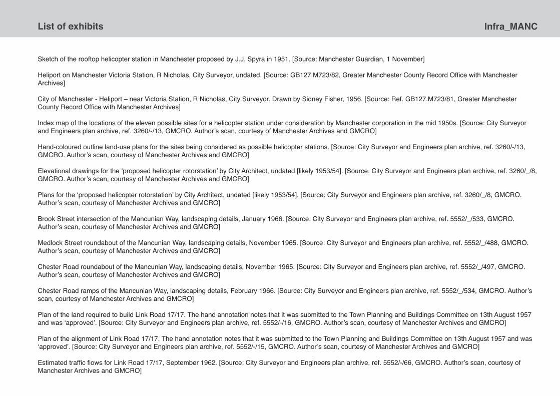
Infra_MANCList of exhibits
Sketch of the rooftop helicopter station in Manchester proposed by J.J. Spyra in 1951. [Source: Manchester Guardian, 1 November]
Heliport on Manchester Victoria Station, R Nicholas, City Surveyor, undated. [Source: GB127.M723/82, Greater Manchester County Record Office with Manchester Archives]
City of Manchester - Heliport – near Victoria Station, R Nicholas, City Surveyor. Drawn by Sidney Fisher, 1956. [Source: Ref. GB127.M723/81, Greater Manchester County Record Office with Manchester Archives]
Index map of the locations of the eleven possible sites for a helicopter station under consideration by Manchester corporation in the mid 1950s. [Source: City Surveyor and Engineers plan archive, ref. 3260/-/13, GMCRO. Author’s scan, courtesy of Manchester Archives and GMCRO]
Hand-coloured outline land-use plans for the sites being considered as possible helicopter stations. [Source: City Surveyor and Engineers plan archive, ref. 3260/-/13, GMCRO. Author’s scan, courtesy of Manchester Archives and GMCRO]
Elevational drawings for the ‘proposed helicopter rotorstation’ by City Architect, undated [likely 1953/54]. [Source: City Surveyor and Engineers plan archive, ref. 3260/_/8, GMCRO. Author’s scan, courtesy of Manchester Archives and GMCRO]
Plans for the ‘proposed helicopter rotorstation’ by City Architect, undated [likely 1953/54]. [Source: City Surveyor and Engineers plan archive, ref. 3260/_/8, GMCRO. Author’s scan, courtesy of Manchester Archives and GMCRO]
Brook Street intersection of the Mancunian Way, landscaping details, January 1966. [Source: City Surveyor and Engineers plan archive, ref. 5552/_/533, GMCRO. Author’s scan, courtesy of Manchester Archives and GMCRO]
Medlock Street roundabout of the Mancunian Way, landscaping details, November 1965. [Source: City Surveyor and Engineers plan archive, ref. 5552/_/488, GMCRO. Author’s scan, courtesy of Manchester Archives and GMCRO]
Chester Road roundabout of the Mancunian Way, landscaping details, November 1965. [Source: City Surveyor and Engineers plan archive, ref. 5552/_/497, GMCRO. Author’s scan, courtesy of Manchester Archives and GMCRO]
Chester Road ramps of the Mancunian Way, landscaping details, February 1966. [Source: City Surveyor and Engineers plan archive, ref. 5552/_/534, GMCRO. Author’s scan, courtesy of Manchester Archives and GMCRO]
Plan of the land required to build Link Road 17/17. The hand annotation notes that it was submitted to the Town Planning and Buildings Committee on 13th August 1957 and was ‘approved’. [Source: City Surveyor and Engineers plan archive, ref. 5552/-/16, GMCRO. Author’s scan, courtesy of Manchester Archives and GMCRO]
Plan of the alignment of Link Road 17/17. The hand annotation notes that it was submitted to the Town Planning and Buildings Committee on 13th August 1957 and was ‘approved’. [Source: City Surveyor and Engineers plan archive, ref. 5552/-/15, GMCRO. Author’s scan, courtesy of Manchester Archives and GMCRO]
Estimated traffic flows for Link Road 17/17, September 1962. [Source: City Surveyor and Engineers plan archive, ref. 5552/-/66, GMCRO. Author’s scan, courtesy of Manchester Archives and GMCRO]

Infra_MANC List of exhibits
Brook Street intersection, landscaping details. [Source: City Surveyor and Engineers plan archive, ref. 5552/162/533, GMCRO. Author’s scan, courtesy of Manchester Archives and GMCRO]
Manchester Rapid Transport Study Plans, c. 1964. [Source: Ref. GB127. M507/7394/18, Greater Manchester County Record Office with Manchester Archives]
Plan showing sketch plan of City of Manchester central area major road network, undated. [Source: Ref. GB127. M507/7396/7, Greater Manchester County Record Office with Manchester Archives]
The projected alignments of the Mancunian Way, Princess Road and Cambridge Road plotted over existing streets, undated. [Source: Ref. GB127. M507/7392/15, Greater Manchester County Record Office with Manchester Archives]
Original books of contract drawings for the construction of the Mancunian Way. [Source: uncatalogued holdings of the Greater Manchester County Record]
Reproductions of photographs of the construction and fitting out of the Guardian Underground Telephone Exchange in 1955/56. [Source: Photographs were taken by Patrick Gough. Courtesy of Mike Gough and George Coney]
A selection of the photographs taken by Tony Perry [July 1998] as part of an English Heritage photographic study of the Guardian Underground Telephone Exchange. [Source: Ref. AA98/02416, 02420, 020422-24, 020434-36, 020440. Courtesy of English Heritage]
A twenty minute segment from a longer POV video ‘exploration’ of the core parts of the Guardian Underground Telephone Exchange, reportedly shot in 1996. [Source: Courtesy of hogshawrabbits, www.youtube.com/user/hogshawrabbits/feed]
Futuroute, a ‘marketing machine’ to promote the benefits of the Picc-Vic line in the mid 1970s. [Source: On loan from the Museum of Transport Greater Manchester, <www.gmts.co.uk/>. Courtesy of George Turnbull]
Physical display models of the proposed Exchange station on the Picc-Vic line, 1975. [Source: Courtesy of George Turnbull, Museum of Transport Greater Manchester]
Physical display models of the proposed Piccadilly Lower Level station on the Picc-Vic line, 1975. [Source: Courtesy of George Turnbull, Museum of Transport Greater Manchester]
Drilling test boreholes in Manchester city centre in preparation for construction of Picc-Vic tunnel, 1972. [Source: Courtesy of George Turnbull, Museum of Transport Greater Manchester]
Concept drawing of the subway trains envisioned for city by the Manchester Rapid Transit Study in the late 1960s. [Source: Courtesy of George Turnbull, Museum of Transport Greater Manchester]
Concept sketches for the entrance on Albert Square to the Central Station on the Picc-Vic line. Drawn by David Fricker. [Source: Courtesy of David Suggitt, Darnton EGS]Concept sketches for the proposed Royal Exchange Station on the Picc-Vic line. Drawn by David Fricker. [Source: Courtesy of David Suggitt, Darnton EGS]
Concept sketches for the proposed Royal Exchange Station on the Picc-Vic line. Drawn by David Fricker. [Source: Courtesy of David Suggitt, Darnton EGS]

Infra_MANCList of exhibits
Concept sketch for the entrances to the proposed Central Station on the Picc-Vic line. Drawn by David Fricker. [Source: Courtesy of David Suggitt, Darnton EGS]
Concept sketches for the ticket hall and platform for the proposed Royal Exchange Station on the Picc-Vic line. Drawn by David Fricker. [Source: Courtesy of Jan & John Weightman]
Concept sketches for the entrance and concourse for Central Station on the Picc-Vic line. Drawn by David Fricker. [Source: Courtesy of Mark Westgarth]
Concept sketches for the entrance to Whitworth Street Station on the Picc-Vic line. Drawn by David Fricker. [Source: Courtesy of Clive Mainwaring]
Designs for the concourse areas of the underground stations on the Picc-Vic line. Drawn by David Fricker. [Source: Courtesy of David Suggitt, Darnton EGS]
Piccadilly Lower Level Station design, May 1975. [Source: City Surveyor and Engineers plan archive, ref. 6658/_/92, GMCRO. Author’s scan, courtesy of Manchester Archives and GMCRO]
Tunnel configuration at the Market Street Station. [Source: City Surveyor and Engineers plan archive, ref. 6658/_/25, GMCRO. Author’s scan, courtesy of Manchester Archives and GMCRO]
Tunnel dimensions for the Picc-Vic line. [Source: City Surveyor and Engineers plan archive, ref. 6658/_/4, GMCRO. Author’s scan, courtesy of Manchester Archives and GMCRO]
Subsurface configuration of the underground stations for the Picc-Vic line. [Source: City Surveyor and Engineers plan archive, ref. 6658/_/16, GMCRO. Author’s scan, courtesy of Manchester Archives and GMCRO]
Subsurface configuration of the Market Street [Royal Exchange] Station. [Source: City Surveyor and Engineers plan archive, ref. 6658/_/5, GMCRO. Author’s scan, courtesy of Manchester Archives and GMCRO]
Trackplan of the Picc-Vic line, detailing the junctions, signalling system and storage depots, etc., January 1973. [Source: Ref. AN 129/64. Courtesy of The National Archives]
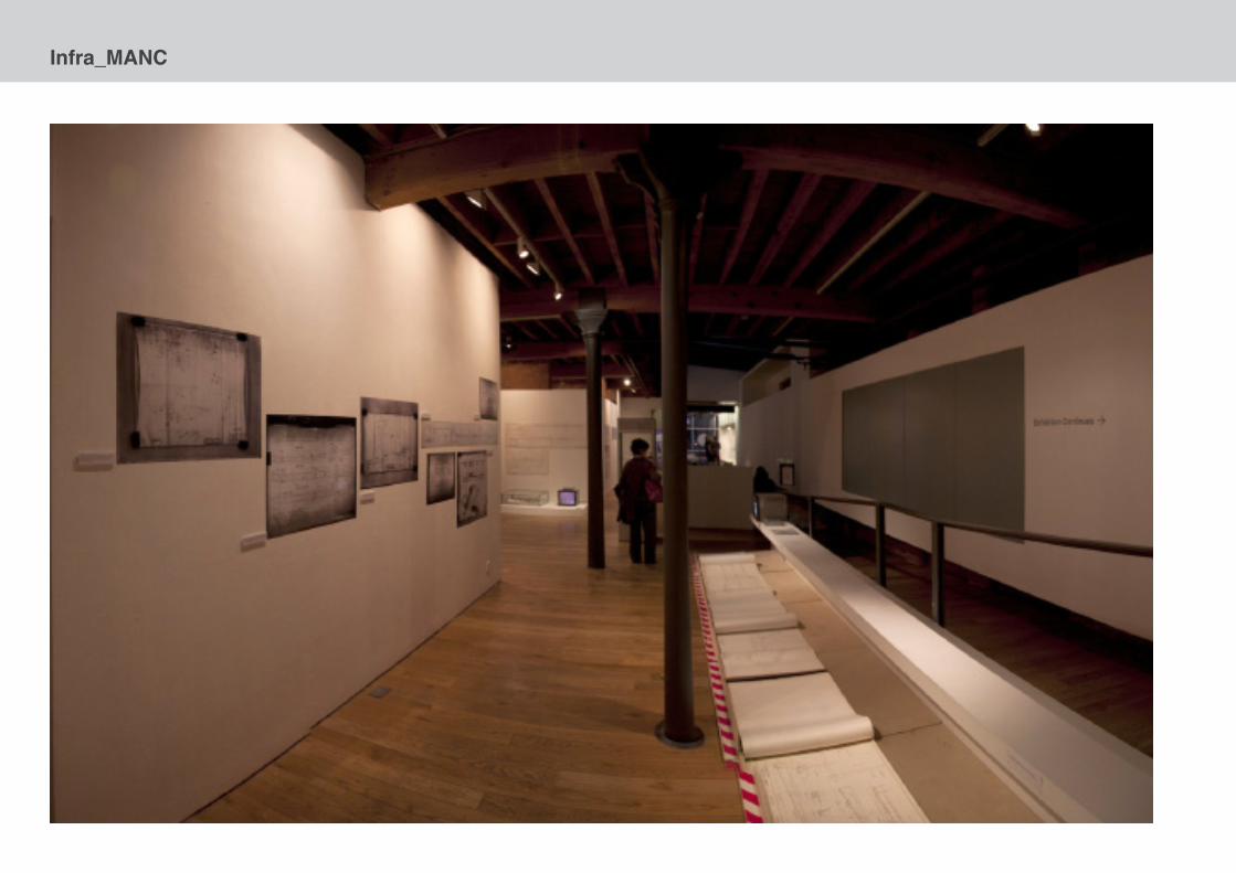
Infra_MANC

Infra_MANC
Exhibition photographs courtesy Michael England.
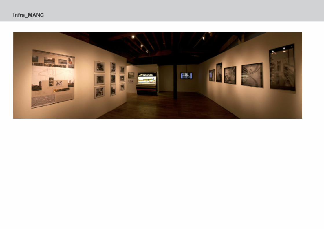
Infra_MANC
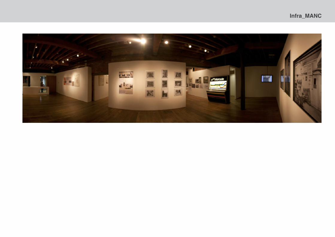
Infra_MANC
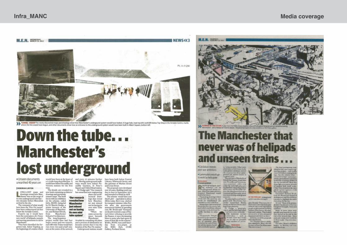
Infra_MANC Media coverage

Infra_MANCMedia coverage
Press and media coverage
“Revealed: The 1950S Plan for a Futuristic Manchester of Helipads andUnderground Trains”, Manchester Evening News, 23 February 2012, p.3.
BBC News: Manchester website slideshow, 25 February 2012.<www.bbc.co.uk/news/uk-england-manchester-17160098>
BBC Radio Manchester, ‘drive-time’, Thursday 23rd February.
BBC Northwest Tonight, regional television news, Tuesday 28th February2012.
“Down the Tube... Manchester’s Lost Underground”, Manchester Evening News,14 March 2012, p.3.
BBC Radio Manchester, ‘breakfast show’, Wednesday 14 March???, 2012.
“Manchester’s tube train that never was”, The Northerner Blog, TheGuardian, 14 March 2012.<www.guardian.co.uk/uk/the-northerner/2012/mar/14/manchester-localgovernment-underground-trains-picc-vic-secret-telephone-exchange>
Selected visitor comments
Fascinating look at the modernist future we almost had.... tantalisingly close!
Really interesting to see infrastructural projects contextualised in relation to a vision for Manchester and in relation to the period. Interesting and informative. Thank you.
As a transport analyst working at TFGM, I found the exhibition very interesting and have often heard more experience colleagues refer to SELNEC! I will recommend.
Sublime collection of images. Really stunning technical drawing. Am envious, there is not a smudge in sight! Beautiful exhibition of post-war utopian vision. Thank you.
Wonderful – I was here as a student in the 1970s and it is good to see this exhibition 40 years on, in the light of day. If Manchester gets a big exhibition space (old mills) this should form part of a permanent display – for me more interesting than some of those on ‘The City’ at the ill fated Urbis.
Audited visitor numbers
2,101 [24 Feb - 17 March 2012]