initial study - fresno
TRANSCRIPT

INITIAL STUDY
Parc West Development Project
March 2020
PREPARED BY:
Crawford & Bowen Planning, Inc.
113 N. Church Street, Suite 302
Visalia, CA 93291
PREPARED FOR:
City of Fresno
Development and Resource Management Dept.
2600 Fresno Street
Fresno, CA 93721

Initial Study
Parc West Development Project
Prepared for:
City of Fresno
Development and Resource Management Department
2600 Fresno Street
Fresno, CA 93721
(559) 621-8024
Contact: Will Tackett
Prepared by:
Crawford & Bowen Planning, Inc.
113 N. Church Street, Suite 302
Visalia, CA 93291
(559) 840-4414
Contact: Travis Crawford, AICP
March 2020

TABLE OF CONTENTS
CHAPTER ONE - INTRODUCTION
1.1 Project Summary 1-1
1.2 Project Background 1-1
1.3 Purpose of Initial Study 1-2
1.4 Document Format 1-2
CHAPTER TWO – PROJECT DESCRIPTION
2.1 Project Location and Setting 2-1
2.2 Project Description 2-2
2.3 Project Objectives 2-3
2.4 Other Required Approvals 2-9
CHAPTER THREE – INITIAL STUDY CHECKLIST
3.1 Environmental Checklist Form 3-1
3.2 Environmental Factors Potentially Affected 3-4
3.3 Determination 3-4
I. Aesthetics 3-6
II. Agricultural and Forest Resources 3-9
III. Air Quality 3-12
IV. Biological Resources 3-16
V. Cultural Resources 3-22
VI. Energy 3-25
VII. Geology and Soils 3-27
VIII. Greenhouse Gas Emissions 3-33
IX. Hazards and Hazardous Materials 3-35
X. Hydrology 3-42
XI. Land Use and Planning 3-44
XII. Mineral Resources 3-48
XIII. Noise 3-49
XIV. Population and Housing 3-50
XV. Public Services 3-53
XVI. Recreation 3-54
XVII. Transportation / Traffic 3-56
XVIII. Tribal Cultural Resources 3-57
XIX. Utilities and Service Systems 3-59
XX. Wildfire 3-61
CHAPTER FOUR – MITIGATION MONITORING PROGRAM 4-1
Project-Specific Mitigation Program
Fresno General Plan MEIR Mitigation Checklist
CHAPTER FIVE – LIST OF PREPARERS 5-1

(Contd.)
LIST OF FIGURES
1 – Regional Map 2-4
2 – Site Aerial Vicinity Map 2-5
3 – Project Site Plan 2-6
4 – Parc West in Relation to Previous Westlake Project Site 2-7
5 – Existing Zoning 2-8
LIST OF TABLES
1 – Standards and Attainment Status 3-13
2 – 2016 CA Energy Consumption 3-26

Chapter 1
INTRODUCTION

Parc West Development Project | Chapter 1
CITY OF FRESNO | Crawford & Bowen Planning, Inc. 1-1
INTRODUCTION
1.1 Project Summary
This document is the Initial Study (IS) on the potential environmental effects of the proposed Parc
West Development Project (Project). The Project Applicant is proposing to develop up to 844
single-family residential units, a neighborhood park and trails on approximately 160 acres at the
northwest corner of Ashlan Avenue and Grantland Avenue in the City of Fresno. The proposed
Project is more fully described in Chapter Two – Project Description.
The City of Fresno will act as the Lead Agency for this Project pursuant to the California
Environmental Quality Act (CEQA) and the CEQA Guidelines.
1.2 Project Background
The subject site was part of the previously approved Westlake Development Project and was
analyzed in the Westlake EIR (State Clearinghouse #2007121033). The Westlake Project analyzed
approximately 2,600 residential units, 295,000 sq. ft. of commercial space, and a 55-acre man-
made lake on 430 acres. Following certification of the Westlake EIR, the Project Applicant
(Granville Homes) put the Project on hold. Since that time, the Applicant has scaled down the
Project to include only 844 units on 160 acres. As of Fall 2019, the site is planted in almonds.
While the environmental impacts of buildout of the subject site was included in the Westlake EIR,
this Initial Study is being prepared independently to assess the environmental impacts associated
with the updated Project. Where applicable, this Initial Study refers to some information from the
certified Westlake EIR (SCH No. 2007121033). However, due to the lapse in time and because of
changes in development intensity in the area, only limited areas of the previous environmental
analysis remain applicable. These instances are noted within the document. The Westlake EIR
and associated documents may be examined at the City of Fresno Development and Resource
Management Department, City Hall, 2600 Fresno Street, Room 3043, Fresno, California 93721-
3604.
In addition, this Initial Study also uses information from the City’s Master Environmental Impact
Report (MEIR) State Clearing House (SCH) No. 2012111015 that was prepared and adopted for
the Fresno General Plan. Where mitigation measures or other information from the MEIR are
applicable, it has been noted in this Initial Study. Although this document is not tiering off of the
MEIR, there is some information in the MEIR that is applicable to the Parc West analysis. These
instances are noted within the document. The General Plan MEIR and associated documents may

Parc West Development Project | Chapter 1
CITY OF FRESNO | Crawford & Bowen Planning, Inc. 1-2
be examined at the City of Fresno Development and Resource Management Department, City
Hall, 2600 Fresno Street, Room 3043, Fresno, California 93721-3604.
1.3 Purpose of Initial Study
An Initial Study is a preliminary analysis which is prepared to determine the relative
environmental impacts associated with a proposed project. It is designed as a measuring
mechanism to determine if a project will have a significant adverse effect on the environment,
thereby triggering the need to prepare an Environmental Impact Report (EIR). This Initial Study
has been prepared consistent with CEQA Guidelines Section 15063, to determine if the proposed
Parc West Development Project may have a significant effect upon the environment. A Notice of
Preparation (NOP) of an EIR has been prepared along with this IS.
1.4 Document Format
This IS/MND contains five chapters, and appendices. Chapter 1, Introduction, provides an
overview of the Project and the CEQA environmental documentation process. Chapter 2, Project
Description, provides a detailed description of Project objectives and components. Chapter 3,
Initial Study Checklist, presents the CEQA checklist and environmental analysis for all impact
areas, mandatory findings of significance, and feasible mitigation measures. If the proposed
Project does not have the potential to significantly impact a given issue area, the relevant section
provides a brief discussion of the reasons why no impacts are expected. If the Project could have
a potentially significant impact on a resource, the issue area discussion provides a description of
potential impacts, and appropriate mitigation measures and/or permit requirements that would
reduce those impacts to a less than significant level. Chapter 4, Mitigation and Monitoring
Program provides the list of applicable mitigation measures that must be complied with. There
are two mitigation lists: a Project-specific mitigation program and the City’s General Plan Master
EIR mitigation checklist. Both are applicable to the Project. Chapter 5, List of Preparers, provides
a list of key personnel involved in the preparation of the IS/MND.
Environmental impacts are separated into the following categories:
Potentially Significant Impact. This category is applicable if there is substantial evidence that
an effect may be significant, and no feasible mitigation measures can be identified to reduce
impacts to a less than significant level. If there are one or more “Potentially Significant Impact”
entries when the determination is made, an EIR is required.
Less Than Significant After Mitigation Incorporated. This category applies where the
incorporation of mitigation measures would reduce an effect from a “Potentially Significant

Parc West Development Project | Chapter 1
CITY OF FRESNO | Crawford & Bowen Planning, Inc. 1-3
Impact” to a “Less Than Significant Impact.” The lead agency must describe the mitigation
measure(s), and briefly explain how they would reduce the effect to a less than significant level
(mitigation measures from earlier analyses may be cross-referenced).
Less Than Significant Impact. This category is identified when the project would result in
impacts below the threshold of significance, and no mitigation measures are required.
No Impact. This category applies when a project would not create an impact in the specific
environmental issue area. “No Impact” answers do not require a detailed explanation if they are
adequately supported by the information sources cited by the lead agency, which show that the
impact does not apply to the specific project (e.g., the project falls outside a fault rupture zone).
A “No Impact” answer should be explained where it is based on project-specific factors as well
as general standards (e.g., the project will not expose sensitive receptors to pollutants, based on
a project-specific screening analysis.)
Regardless of the type of CEQA document that must be prepared, the basic purpose of the CEQA
process as set forth in the CEQA Guidelines Section 15002(a) is to:
(1) Inform governmental decision makers and the public about the potential, significant
environmental effects of proposed activities.
(2) Identify ways that environmental damage can be avoided or significantly reduced.
(3) Prevent significant, avoidable damage to the environment by requiring changes in
projects through the use of alternatives or mitigation measures when the
governmental agency finds the changes to be feasible.
(4) Disclose to the public the reasons why a governmental agency approved the project
in the manner the agency chose if significant environmental effects are involved.
The Initial Study contained in Section Three of this document has determined that there are
potentially significant impacts associated with the Project and an EIR will be prepared.

Chapter 2
PROJECT DESCRIPTION

Parc West Development Project | Chapter 2
CITY OF FRESNO | Crawford & Bowen Planning, Inc. 2-1
Project Description
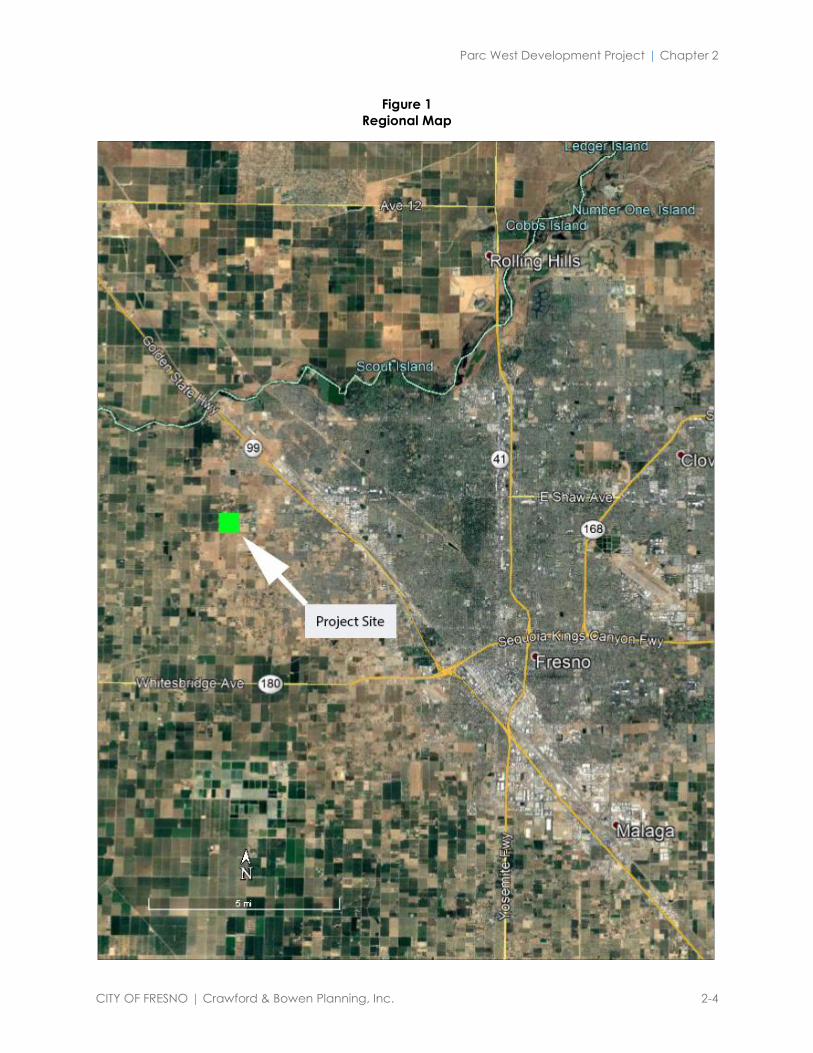
2.1 Project Location and Setting
The proposed Parc West Project is located on approximately 160 acres north of the W. Ashlan
alignment and west of N. Grantland Avenue within the city limits of Fresno, CA (See Figures 1
through 4).
The site is within the City limits of Fresno (annexed in 2015) and occupies Assessor’s Parcel
Numbers 512-02-126 and 512-02-150S. The site is currently planted with relatively young almond
trees but was previously vacant for several years. Surrounding land uses are as follows:
Surrounding Land Use and Zoning
Location Existing Land
Use
Roadway
North Rural residential (outside City
limits)
None existing. Planned for
W. Gettysburg Ave.
South Agricultural (almonds) – site of
original Westlake project
None existing. Planned for
W. Ashlan Ave.
West Agricultural (outside City limits) None existing. Planned for
N. Garfield Ave.
East Central Unified School District
Complex (football stadium,
schools, transportation center)
N. Grantland Ave.
Most of the Project site is designated by the City of Fresno General Plan as Medium Density
Residential (5.0 – 12 D.U./acre). There is an 10-acre portion of the site at the southeast corner of
the lot that is zoned and designated Community Commercial, however, the Applicant is
proposing to change this land use from commercial to residential (RS-5) to match the land use
designation of the remainder of the 160 acres. See Figure 5 – Existing Zoning.
Much of the land surrounding the Project site is in agricultural production or occupied by rural
residential homes and ancillary structures. The CUSD Deran Koligian Education Center is
located east of Grantland Avenue and south of Ashlan Avenue proximate to the proposed Project
site. Large lot single family homes are located along West Rialto Avenue adjacent to, and north
of, the Project site.

Parc West Development Project | Chapter 2
CITY OF FRESNO | Crawford & Bowen Planning, Inc. 2-2
2.2 Project Description
Parc West will include construction of up to 844 single-family residential units, a 1.819-acre park
and installation of a trail system that will connect to the City’s existing/future trail network in the
area. The Project will be built out in phases, with Phase 1 generating 84 units. The general layout
of the Project is shown in Figure 3.
Site Circulation
The Project will require the extension of W. Ashlan Avenue and N. Garfield Avenue to intersect
and the streets will be required to be improved to City standards. Site access will occur from N.
Grantland Avenue and from the proposed W. Ashlan Avenue and N. Garfield Avenue
extensions. Preliminary internal road circulation and layout are shown in Figure 3. The Project
Applicant will be responsible for construction and/or fair share contributions for the roadway
improvements. See Section 3.17 – Transportation / Traffic for more information.
Infrastructure
The Project will be required to tie into existing infrastructure in the area for sewer, water and
storm drain. The existing pipelines for these services are located within the adjacent streets. The
Project developer will be required to pay for all improvements related to obtaining these facilities
to serve the Project. This includes constructing appropriately sized water mains that will provide
adequate water pressure for fire flow and Project water use. The Project will require installation
of sewer mains to serve the Project including any sewer easements that will be required by the
City.
The Project is proposed to be supported by the City of Fresno’s municipal water supply system
(see discussion pertaining to water supply in Section 3.10 – Hydrology and the Water Supply
Assessment Update that was provided for the Project) and its wastewater collection system
(including the Grantland trunk sewer) and wastewater / treatment disposal facilities. The major
service public utility is Pacific Gas and Electric. Refer to Section 3.19 – Utilities for further
discussion.
The Project has been reviewed by City of Fresno Public Works and specifications pertaining to
Project financial responsibilities for accessing City-provided services have been made conditions
of Project approval.
Project Schedule
The Project developer intends to begin construction activities in late 2020.

Parc West Development Project | Chapter 2
CITY OF FRESNO | Crawford & Bowen Planning, Inc. 2-3
2.3 Project Objectives
In accordance with CEQA Guidelines Section 15124(b), the following are the City of Fresno’s
Project objectives:
• To provide a variety of housing opportunities with a range of densities, styles, sizes
and values that will be designed to satisfy existing and future demand for quality
housing in the area.
• To provide a sense of community and walkability within the development through
the use of street patterns, parks/open space areas, landscaping and other Project
amenities.
• To create a successful and financially feasible Project by meeting the housing needs of
the area.
• To provide a residential development that assists the City in meeting its General Plan
and Housing Element requirements and objectives.
Parc West Development Project | Chapter 2
CITY OF FRESNO | Crawford & Bowen Planning, Inc. 2-4
Figure 1
Regional Map

Parc West Development Project | Chapter 2
CITY OF FRESNO | Crawford & Bowen Planning, Inc. 2-5
Figure 2
Site Aerial Vicinity Map

Parc West Development Project | Chapter 2
CITY OF FRESNO | Crawford & Bowen Planning, Inc. 2-6
Figure 3
Project Site Plan

Parc West Development Project | Chapter 2
CITY OF FRESNO | Crawford & Bowen Planning, Inc. 2-7
Figure 4
Parc West in Relation to Previous Westlake Project Site

Parc West Development Project | Chapter 2
CITY OF FRESNO | Crawford & Bowen Planning, Inc. 2-8
Figure 5
Existing Zoning
Entitlements
In support of the Parc West Project, the Applicant is seeking the following entitlements from the
City of Fresno:
• General Plan Amendment: Medium Density Residential land use designation (5.0 –
12.0 DU/acre), Traffic Circulation Plan, Parks, Open Space and Trail Network.
• Rezoning: A 10-acre section originally intended for commercial development will be
re-zoned RS-5 and will include removal of the previous Westlake Development Project
conditions to be replaced with new conditions appropriate for the Parc West
Development. The remaining acreage will remain RS-5 and will not require land use
designation or zoning changes.
• Tentative Tract Map to create “super-pads” for future subdivisions.
• Community Facilities District for maintenance of the public green spaces.
• Grading and building permits.

Parc West Development Project | Chapter 2
CITY OF FRESNO | Crawford & Bowen Planning, Inc. 2-9
2.4 Other Required Approvals
The Project will require various regulatory approvals, permits, entitlements and/or coordination
with agencies as follows:
• Certification of the forthcoming EIR by the City of Fresno.
• Compliance with other federal, state and local requirements such as the San Joaquin
Valley Air Pollution Control District for a dust control plan and the Regional Water
Quality Control Board for a Stormwater Pollution Prevention Plan.
• City of Fresno Department of Public Utilities – Solid Waste
• Fresno Irrigation District
• Fresno Metropolitan Flood Control District
• City of Fresno Fire Department
• City of Fresno Public Works Department
• Central Unified School
• Fresno County Environmental Health

Chapter 3
IMPACT ANALYSIS

Parc West Development Project | Chapter 3
CITY OF FRESNO | Crawford & Bowen Planning, Inc. 3-1
Initial Study Checklist
3.1 Environmental Checklist Form
Project title: Parc West Development Project
Lead agency name and address:
City of Fresno
Development and Resource Management Department
2600 Fresno Street, Room 3065
Fresno, CA 93721
Contact person and phone number:
Will Tackett
City of Fresno
(559) 621-8024
Project location:
The proposed Parc West Project is located on approximately 160 acres north of the W.
Ashlan alignment and west of N. Grantland Avenue within the city limits of Fresno,
CA (See Figures 1 through 4). The site is within the City limits of Fresno (annexed in
2015) and occupies Assessor’s Parcel Numbers 512-02-126 and 512-02-150S.
Project sponsor’s name/address:
City of Fresno
2600 Fresno Street
Fresno, CA 93721
General plan designation:
The project site is designated by the City of Fresno General Plan as Medium
Density Residential (5.0 – 12 D.U./acre) and Community Commercial.

Parc West Development Project | Chapter 3
CITY OF FRESNO | Crawford & Bowen Planning, Inc. 3-2
Zoning:
RS-5 (Medium Density Residential) and CC (Community Commercial)
Description of project:
Parc West will include construction of up to 844 single-family residential units, a
1.819-acre park and installation of a trail system that will connect to the City’s
existing/future trail network in the area. The Project will be built out in phases, with
Phase 1 generating 84 units. The general layout of the Project is shown in Figure 3.
Surrounding land uses/setting:
The site is currently planted with relatively young almond trees but was previously
vacant for several years. Much of the land surrounding the Project site is in
agricultural production or occupied by rural residential homes and ancillary
structures. The CUSD Deran Koligian Education Center is located east of Grantland
Avenue and south of Ashlan Avenue proximate to the proposed Project site. Large
lot single family homes are located along West Rialto Avenue adjacent to, and north
of, the Project site.
California Native American Tribal Consultation:
Have California Native American tribes traditionally and culturally affiliated with the
project area requested consultation pursuant to Public Resources Code section 21080.3.1?
If so, has consultation begun or is there a plan for consultation that includes, for example,
the determination of significance of impacts to tribal cultural resources, procedures
regarding confidentiality, etc.?
In accordance with Assembly Bill (AB) 52 and Senate Bill (SB) 18, potentially
affected Tribes were formally notified of this Project February 25, 2019, and were
given the opportunity to request consultation on the Project. The City contacted
the Native American Heritage Commission, requesting a contact list of applicable
Native American Tribes, which was provided to the City. The City provided
letters to the listed Tribes, notifying them of the Project and requesting
consultation, if desired. The City did not receive any responses from the tribes

Parc West Development Project | Chapter 3
CITY OF FRESNO | Crawford & Bowen Planning, Inc. 3-3
contacted. Refer to Section XVIII – Tribal Cultural Resources for more
information.
Other public agencies whose approval or consultation is required (e.g., permits,
financing approval, participation agreements):
The Project will require various regulatory approvals, permits, entitlements and/or
coordination with agencies as follows:
• Certification of the forthcoming EIR by the City of Fresno.
• Compliance with other federal, state and local requirements such as the San Joaquin
Valley Air Pollution Control District for a dust control plan and the Regional Water
Quality Control Board for a Stormwater Pollution Prevention Plan.
• City of Fresno Department of Public Utilities – Solid Waste
• Fresno Irrigation District
• Fresno Metropolitan Flood Control District
• City of Fresno Fire Department
• City of Fresno Public Works Department
• Central Unified School
• Fresno County Environmental Health

Parc West Development Project | Chapter 3
CITY OF FRESNO | Crawford & Bowen Planning, Inc. 3-4
3.2 Environmental Factors Potentially Affected
The environmental factors checked below would be potentially affected by this Project, involving at least
one impact that is a “Potentially Significant Impact” as indicated by the checklist on the following pages.
Aesthetics Agriculture Resources
and Forest Resources
Air Quality
Biological Resources Cultural Resources Energy
Geology / Soils Greenhouse Gas
Emissions
Hazards &
Hazardous
Materials
Hydrology / Water
Quality
Land Use / Planning Mineral Resources
Noise Population / Housing Public Services
Recreation Transportation Tribal Cultural
Resources
Utilities / Service
Systems
Wildfire
3.3 Determination
Based on this initial evaluation:
I find that the proposed project COULD NOT have a significant effect on the environment,
and a NEGATIVE DECLARATION will be prepared.
I find that although the proposed project could have a significant effect on the environment,
there will not be a significant effect in this case because revisions in the project have been
made by or agreed to by the project proponent. A MITIGATED NEGATIVE DECLARATION
will be prepared.
I find that the proposed project MAY have a significant effect on the environment, and an
ENVIRONMENTAL IMPACT REPORT is required.
I find that the proposed project MAY have a “potentially significant impact” or “potentially
significant unless mitigated” impact on the environment, but at least one effect 1) has been
adequately analyzed in an earlier document pursuant to applicable legal standards, and 2)
has been addressed by mitigation measures based on the earlier analysis as described on
attached sheets. An ENVIRONMENTAL IMPACT REPORT is required, but it must analyze

Parc West Development Project | Chapter 3
CITY OF FRESNO | Crawford & Bowen Planning, Inc. 3-5
only the effects that remain to be addressed.
I find that although the proposed project could have a significant effect on the environment,
because all potentially significant effects (a) have been analyzed adequately in an earlier EIR
or NEGATIVE DECLARATION pursuant to applicable standards, and (b) have been avoided
or mitigated pursuant to that earlier EIR or NEGATIVE DECLARATION, including revisions
or mitigation measures that are imposed upon the proposed project, nothing further is
required.
Israel Trejo, Project Planner
City of Fresno
Date

Parc West Development Project | Chapter 3
CITY OF FRESNO | Crawford & Bowen Planning, Inc. 3-6
I. AESTHETICS Except as provided in Public Resources
Code Section 21099, would the project:
Potentially
Significant
Impact
Less than
Significant
With
Mitigation
Incorporation
Less than
Significant
Impact
No
Impact
a. Have a substantial adverse effect on a
scenic vista?
b. Substantially damage scenic resources,
including, but not limited to, trees, rock
outcroppings, and historic buildings within
a state scenic highway?
c. In non-urbanized areas, substantially
degrade the existing visual character or
quality of public views of the site and its
surroundings? (Public views are those that
are experienced from publicly accessible
vantage point). If the project is in an
urbanized area, would the project conflict
with applicable zoning and regulations
governing scenic quality?
d. Create a new source of substantial light or
glare which would adversely affect day or
nighttime views in the area?
AFFECTED ENVIRONMENT
The Project site is planted in almonds and is generally flat with unobstructed views of the surrounding
agricultural lands, educational facilities, rural residential and light industrial land uses. Neither the
Project site nor any of the surrounding land uses contains features typically associated with scenic vistas
(e.g. ridgelines, peaks, overlooks). Therefore, little opportunity exists for Project development to
obscure views of scenic vistas that may be located within the immediate area of the Project site.
RESPONSES
a. Have a substantial adverse effect on a scenic vista?
b. Substantially damage scenic resources, including, but not limited to, trees, rock outcroppings,

Parc West Development Project | Chapter 3
CITY OF FRESNO | Crawford & Bowen Planning, Inc. 3-7
and historic buildings within a state scenic highway?
Less Than Significant Impact. A scenic vista is defined as a viewpoint that provides expansive
views of highly valued landscape for the benefit of the general public. The Sierra Nevada
Mountains are the only natural and visual resource in the Project area. Views of these distant
mountains are afforded only during clear conditions due to poor air quality in the valley. Distant
views of the Sierra Nevada Mountains would largely be unaffected by the development of the
Project because of the nature of the Project, distance and limited visibility of these features. The City
of Fresno does not identify views of these features as required to be “protected.”
The Project site is within a developing area of Fresno. There are no scenic vistas or other protected
scenic resources on or near the site. Visual character of the site is addressed further in Response C.
below. In addition, there are no designated scenic highways near the proposed site.
Therefore, the Project has a less than significant impact on scenic vistas or designated scenic
resources or highways.
Mitigation Measures: None are required.
c. In non-urbanized areas, substantially degrade the existing visual character or quality of public
views of the site and its surroundings? (Public views are those that are experienced from publicly
accessible vantage point). If the project is in an urbanized area, would the project conflict with
applicable zoning and regulations governing scenic quality?
Less Than Significant Impact. Implementation of the proposed Project will alter the visual
character of the Project site from an almond orchard to residential development. Although this land
use conversion could be perceived by some as a negative aesthetic impact in comparison with the
Project site’s current pastoral appearance, based upon the subjective nature of aesthetics, the City
does not anticipate that the development of the proposed Project with residences will create a
visually degraded character or quality to the Project site or to the properties near and around the
Project site.
The Project design is subject to the City’s Design Guidelines adopted for the City’s General Plan
which apply to site layout, building design, landscaping, interior street design, lighting, parking
and signage. Detailed architectural plans, color palettes and building materials as well as
landscaping plans will be submitted by the Project developer to the City of Fresno Development
and Resource Management Department. The plans shall be required prior to issuance of any
building permits.

Parc West Development Project | Chapter 3
CITY OF FRESNO | Crawford & Bowen Planning, Inc. 3-8
Landscaping easements will run along the frontage of the development and additional landscaping
design will accompany the aforementioned park space and bicycle/ pedestrian use trail.
The improvements such as those proposed by the Project are typical of large City urban areas and
are generally expected from residents of the City. These improvements would not substantially
degrade the visual character of the area and would not diminish the visual quality of the area, as they
would be consistent with the existing visual setting and development patterns in the area. The
Project itself is not visually imposing against the scale of the existing development and nature of the
surrounding area.
Therefore, the Project would have less than significant impacts on the visual character of the area.
Mitigation Measures: None are required.
d. Create a new source of substantial light or glare which would adversely affect day or nighttime
views in the area?
Less Than Significant Impact With Mitigation.
The subject site currently has no on-site sources of lighting. The Project will introduce new lighting
that will be typical of residential developments, such as streetlights, residential lights and vehicle
lights. Additional night lighting sources on the Project site, especially any unshielded light, could
result in spillover light that could impact surrounding adjacent residential uses. This would create
new sources of light that could potentially have a significant impact on nighttime light levels in the
area. During the entitlement process, staff will ensure that lights are located in areas that will
minimize light sources to the neighboring properties. Further, Mitigation Measures AES-1 through
AES-3 from the General Plan MEIR require lighting systems to be shielded to direct light to ground
surfaces and orient light away from adjacent properties. In addition, AES – 5 requires use of non-
reflective building materials to reduce glare impacts.
In addition, a condition of approval will require that lighting, where provided for public streets, shall
be hooded and so arranged and controlled so as not to cause a nuisance either to traffic or to the
living environment. The amount of light shall be provided according to the standards of the
Department of Public Works. As a result, the Project will implement the necessary mitigation
measures and will have a less than significant impact on aesthetics.
Mitigation Measures: General Plan MEIR Mitigation Measures AES – 1, AES – 2, AES – 3 and
AES – 5. See attached MEIR Mitigation Measure Monitoring Checklist.

Parc West Development Project | Chapter 3
CITY OF FRESNO | Crawford & Bowen Planning, Inc. 3-9
II. AGRICULTURE AND
FOREST RESOURCES Would the project:
Potentially
Significant
Impact
Less than
Significant
With
Mitigation
Incorporation
Less than
Significant
Impact
No
Impact
a. Convert Prime Farmland, Unique
Farmland, or Farmland of Statewide
Importance (Farmland), as shown on the
maps prepared pursuant to the Farmland
Mapping and Monitoring Program of the
California Resources Agency, to non-
agricultural use?
b. Conflict with existing zoning for
agricultural use, or a Williamson Act
contract?
c. Conflict with existing zoning for, or cause
rezoning of, forest land (as defined in
Public Resources Code section 12220(g)),
timberland (as defined by Public
Resources Code section 4526), or
timberland zoned Timberland Production
(as defined by Government Code section
51104(g))?
d. Result in the loss of forest land or
conversion of forest land to non-forest
use?
e. Involve other changes in the existing
environment which, due to their location
or nature, could result in conversion of
Farmland, to non-agricultural use or
conversion of forest land to non-forest
use?

Parc West Development Project | Chapter 3
CITY OF FRESNO | Crawford & Bowen Planning, Inc. 3-10
AFFECTED ENVIRONMENT
Fresno is located in Fresno County, which is a nationally-leading agricultural producer. The City’s
General Plan contains several policies intended to protect agricultural resources. The 160-acre Project
site is planted in almond trees.
RESPONSES
a. Convert Prime Farmland, Unique Farmland, or Farmland of Statewide Importance (Farmland),
as shown on the maps prepared pursuant to the Farmland Mapping and Monitoring Program of
the California Resources Agency, to non-agricultural use?
b. Conflict with existing zoning for agricultural use, or a Williamson Act contract?
c. Conflict with existing zoning for, or cause rezoning of, forest land (as defined in Public
Resources Code section 12220(g)), timberland (as defined by Public Resources Code section
4526), or timberland zoned Timberland Production (as defined by Government Code section
51104(g))?
d. Result in the loss of forest land or conversion of forest land to non-forest use?
e. Involve other changes in the existing environment which, due to their location or nature, could
result in conversion of Farmland, to non-agricultural use or conversion of forest land to non-
forest use?
No Impact. The Project will result in the loss of approximately 160 acres of almond orchard that will be
converted to residential housing. However, the site has been zoned for residential use by the City of
Fresno and the City’s General Plan has designated the site for urban development. There are no
Williamson Act parcels on the site. According to the California Department of Conservation, Division of
Land Resource Protection’s Farmland Mapping and Monitoring Program, Farmland of Statewide
Importance and Unique Farmland occupy the proposed Project site.
The EIR for the City of Fresno General Plan found the conversion of applicable agricultural land, including
the Project site, to urban uses to be a significant and unavoidable impact. As part of adopting the City
General Plan, the Fresno City Council adopted findings of fact and a statement of overriding
considerations that indicated urban development was of greater benefit to the community than preserving
agricultural land within city limits. Although conversion of the Project area to urban uses would reflect
the land use assumptions contained in the City of Fresno General Plan, farmland is an important resource
to the region. As such, Mitigation Measure AG – 1 is included to reduce potential conflicts between urban
and agricultural uses (See Project Specific Mitigation Measure Monitoring Checklist). This measure

Parc West Development Project | Chapter 3
CITY OF FRESNO | Crawford & Bowen Planning, Inc. 3-11
includes a Right-to-Farm Covenant and will help ensure that agricultural operations in the area can be
maintained.
In addition, the Project site was evaluated for loss of agricultural lands under the Westlake Development
Project EIR. That EIR also found the conversion of the applicable agricultural land to be significant and
unavoidable and a Statement of Overriding Considerations was adopted. Since the proposed Project-
related lands have previously been evaluated for loss of agricultural lands, and because the Project site has
been annexed into the City (and the land use designations support residential and commercial uses), the
proposed Project does not result in any impacts beyond what has already been analyzed in previous
documents pertaining to loss of agricultural lands associated with the proposed Project. Therefore, the
Project has no additional impact on agricultural resources. However, Mitigation measure AG-1 is required
to reduce conflicts between urban and agricultural uses.
The proposed Project does not conflict with any forest land or Timberland Production or result in any
loss of forest land. The proposed Project does not include any changes which will affect any forest lands.
Therefore, the Project has no impact on forest resources.
Mitigation Measures: AG – 1 (reduce conflicts between urban and agricultural uses). See attached Project
Specific Mitigation Measure Monitoring Checklist.

Parc West Development Project | Chapter 3
CITY OF FRESNO | Crawford & Bowen Planning, Inc. 3-12
III. AIR QUALITY Would the project:
Potentially
Significant
Impact
Less than
Significant
With
Mitigation
Incorporation
Less than
Significant
Impact
No
Impact
a. Conflict with or obstruct implementation
of the applicable air quality plan?
b. Result in a cumulatively considerable net
increase of any criteria pollutant for
which the project region is non-
attainment under an applicable federal or
state ambient air quality standard?
c. Expose sensitive receptors to substantial
pollutant concentrations?
d. Result in other emissions (such as those
leading to odors or adversely affecting a
substantial number of people)?
AFFECTED ENVIRONMENT
The climate of the City of Fresno and the San Joaquin Valley is characterized by long, hot summers and
stagnant, foggy winters. Precipitation is low and temperature inversions are common. These
characteristics are conducive to the formation and retention of air pollutants and are in part influenced
by the surrounding mountains which intercept precipitation and act as a barrier to the passage of cold
air and air pollutants.
The proposed Project lies within the San Joaquin Valley Air Basin, which is managed by the San Joaquin
Valley Air Pollution Control District (SJVAPCD or Air District). National Ambient Air Quality Standards
(NAAQS) and California Ambient Air Quality Standards (CAAQS) have been established for the
following criteria pollutants: carbon monoxide (CO), ozone (O3), sulfur dioxide (SO2), nitrogen dioxide
(NO2), particulate matter (PM10 and PM2.5), and lead (Pb). The CAAQS also set standards for sulfates,
hydrogen sulfide, and visibility.
Air quality plans or attainment plans are used to bring the applicable air basin into attainment with all
state and federal ambient air quality standards designed to protect the health and safety of residents
within that air basin. Areas are classified under the Federal Clean Air Act as either “attainment”, “non-

Parc West Development Project | Chapter 3
CITY OF FRESNO | Crawford & Bowen Planning, Inc. 3-13
attainment”, or “extreme non-attainment” areas for each criteria pollutant based on whether the NAAQS
have been achieved or not. Attainment relative to the State standards is determined by the California Air
Resources Board (CARB). The San Joaquin Valley is designated as a State and Federal extreme non-
attainment area for O3, a State and Federal non-attainment area for PM2.5, a State non-attainment area
for PM10, and Federal and State attainment area for CO, SO2, NO2, and Pb.
Standards and attainment status for listed pollutants in the Air District can be found in Table 1. Note that
both state and federal standards are presented.
Table 1
Standards and Attainment Status for Listed Pollutants in the Air District
Federal Standard California Standard
Ozone 0.075 ppm (8-hr avg) 0.07 ppm (8-hr avg) 0.09 ppm (1-hr
avg)
Carbon Monoxide 9.0 ppm (8-hr avg) 35.0 ppm (1-hr
avg)
9.0 ppm (8-hr avg) 20.0 ppm (1-hr
avg)
Nitrogen Dioxide 0.053 ppm (annual avg) 0.30 ppm (annual avg) 0.18 ppm
(1-hr avg)
Sulfur Dioxide 0.03 ppm (annual avg) 0.14 ppm
(24-hr avg) 0.5 ppm (3-hr avg)
0.04 ppm (24-hr avg) 0.25 ppm
(1hr avg)
Lead 1.5 µg/m3 (calendar quarter) 0.15
µg/m3 (rolling 3-month avg)
1.5 µg/m3 (30-day avg)
Particulate Matter (PM10) 150 µg/m3 (24-hr avg) 20 µg/m3 (annual avg) 50 µg/m3
(24-hr avg)
Particulate Matter (PM2.5) 15 µg/m3 (annual avg) 35 µg/m3 (24-hr avg) 12 µg/m3 (annual avg)
μg/m3 = micrograms per cubic meter
Additional State regulations include:
CARB Portable Equipment Registration Program – This program was designed to allow owners and
operators of portable engines and other common construction or farming equipment to register their
equipment under a statewide program so they may operate it statewide without the need to obtain a
permit from the local air district.
U.S. EPA/CARB Off-Road Mobile Sources Emission Reduction Program – The California Clean Air Act
(CCAA) requires CARB to achieve a maximum degree of emissions reductions from off-road mobile
sources to attain State Ambient Air Quality Standards (SAAQS); off- road mobile sources include most
construction equipment. Tier 1 standards for large compression-ignition engines used in off-road mobile
sources went into effect in California in 1996. These standards, along with ongoing rulemaking, address
emissions of nitrogen oxides (NOX) and toxic particulate matter from diesel engines. CARB is currently
developing a control measure to reduce diesel PM and NOX emissions from existing off-road diesel
equipment throughout the state.

Parc West Development Project | Chapter 3
CITY OF FRESNO | Crawford & Bowen Planning, Inc. 3-14
California Global Warming Solutions Act – Established in 2006, Assembly Bill 32 (AB 32) requires that
California’s GHG emissions be reduced to 1990 levels by the year 2020. This will be implemented through
a statewide cap on GHG emissions, which will be phased in beginning in 2012. AB 32 requires CARB to
develop regulations and a mandatory reporting system to monitor global warming emissions levels.
The Master Environmental Impact Report (MEIR) prepared for the Fresno General Plan and Policy RC-
4-c of the Fresno General Plan require that computer models used by the SJVAPCD be used to analyze
development projects and estimate future air pollutant emissions that can be expected to be generated
from operational emissions (vehicular traffic associated with the Project), area-wide emissions (sources
such as ongoing maintenance activities and use of appliances), and construction activities.
CalEEMod is a statewide land use emissions computer model designed to provide a uniform platform
for government agencies, land use planners, and environmental professionals to quantify potential
criteria pollutant and greenhouse gas emissions associated with both construction and operations from
a variety of land use projects. The model quantifies direct emissions from construction and operations
(including vehicle and off-road equipment use), as well as indirect emissions, such as GHG emissions
from energy use, solid waste disposal, vegetation planting and/or removal, and water use. Further, the
model identifies mitigation measures to reduce criteria pollutant and GHG emissions along with
calculating the benefits achieved from measures chosen by the user. The GHG mitigation measures were
developed and adopted by the California Air Pollution Control Officers Association (CAPCOA).
In addition to the above-mentioned factors, the CalEEMod computer model evaluates the following
emissions: ozone precursors (Reactive Organic Gases (ROG)) and NOX; CO, SOX, both regulated
categories of particulate matter, and the greenhouse gas carbon dioxide (CO2). The model incorporates
geographically-customized data on local vehicles, weather, and SJVAPCD Rules.
RESPONSES
a. Conflict with or obstruct implementation of the applicable air quality plan?
b. Result in a cumulatively considerable net increase of any criteria pollutant for which the project
region is non-attainment under an applicable federal or state ambient air quality standard?
c. Expose sensitive receptors to substantial pollutant concentrations?
d. Result in other emissions (such as those leading to odors or adversely affecting a substantial number
of people?

Parc West Development Project | Chapter 3
CITY OF FRESNO | Crawford & Bowen Planning, Inc. 3-15
Potentially Significant Impact. The Project may result in exceedance of established thresholds.
Therefore, this impact is potentially significant and this topic will be addressed in the Project’s
forthcoming EIR. The EIR will include an Air Quality / Greenhouse Gas evaluation to assist in the
environmental analysis.

Parc West Development Project | Chapter 3
CITY OF FRESNO | Crawford & Bowen Planning, Inc. 3-16
IV. BIOLOGICAL
RESOURCES Would the project:
Potentially
Significant
Impact
Less than
Significant
With
Mitigation
Incorporation
Less than
Significant
Impact
No
Impact
a. Have a substantial adverse effect, either
directly or through habitat modifications,
on any species identified as a candidate,
sensitive, or special status species in local
or regional plans, policies, or regulations,
or by the California Department of Fish
and Game or U.S. Fish and Wildlife
Service?
b. Have a substantial adverse effect on any
riparian habitat or other sensitive natural
community identified in local or regional
plans, policies, regulations, or by the
California Department of Fish and Game
or U.S. Fish and Wildlife Service?
c. Have a substantial adverse effect on state
or federally protected wetlands
(including, but not limited to, marsh,
vernal pool, coastal, etc.) through direct
removal, filling, hydrological interruption,
or other means?
d. Interfere substantially with the movement
of any native resident or migratory fish or
wildlife species or with established native
resident or migratory wildlife corridors,
or impede the use of native wildlife
nursery sites?

Parc West Development Project | Chapter 3
CITY OF FRESNO | Crawford & Bowen Planning, Inc. 3-17
IV. BIOLOGICAL
RESOURCES Would the project:
Potentially
Significant
Impact
Less than
Significant
With
Mitigation
Incorporation
Less than
Significant
Impact
No
Impact
e. Conflict with any local policies or
ordinances protecting biological
resources, such as a tree preservation
policy or ordinance?
f. Conflict with the provisions of an adopted
Habitat Conservation Plan, Natural
Community Conservation Plan, or other
approved local, regional, or state habitat
conservation plan?

Parc West Development Project | Chapter 3
CITY OF FRESNO | Crawford & Bowen Planning, Inc. 3-18
AFFECTED ENVIRONMENT
The Project site is planted in young almond trees and is subject to ongoing disturbance by intensive
agricultural activities. The immediate vicinity consists of land developed with residences, educational
facilities and agriculture.
The proposed Project site is located in a portion of the central San Joaquin Valley that has, for decades,
experienced intensive agricultural and urban disturbances. Like most of California, Fresno and the
Central San Joaquin Valley experiences a Mediterranean climate. Warm dry summers are followed by
cool moist winters. Summer temperatures usually exceed 90 degrees Fahrenheit, and the relative
humidity is generally very low. Winter temperatures rarely raise much above 70 degrees Fahrenheit,
with daytime highs often below 60 degrees Fahrenheit. Annual precipitation within the proposed Project
site is about 10 inches, almost 85% of which falls between the months of October and March. Nearly all
precipitation falls in the form of rain and storm-water readily infiltrates the soils of the surrounding the
sites.
The Project site is located on the western edge of the City of Fresno, within Sections 17 and 20,
Township 13 S, Range 19 E, Mount Diablo Base and Meridian. Historically, vegetation communities in
the vicinity of the proposed Project site likely consisted of a mosaic of Oak Woodland or Oak Savannah,
Great Valley Mixed Riparian, Freshwater Marsh or Alkali Sink, and Valley Grassland. Lands in the
vicinity of the proposed Project site are currently dominated by residential, commercial and rural
agriculture uses.
Native plant and animal species once abundant in the region have become locally extirpated or have
experienced large reductions in their populations due to conversion of upland, riparian, and aquatic
habitats to agricultural and urban uses. Remaining native habitats are particularly valuable to native
wildlife species including special status species that still persist in the region.
Over the years, the Fresno area has been substantially disturbed by agricultural and residential activities,
with lands within the City itself having primarily been converted to urban development.
RESPONSES
a. Have a substantial adverse effect, either directly or through habitat modifications, on any species
identified as a candidate, sensitive, or special status species in local or regional plans, policies, or
regulations, or by the California Department of Fish and Game or U.S. Fish and Wildlife Service?
Less Than Significant Impact With Mitigation. The site was subject to a previous biological evaluation
under the Westlake Development Project EIR (SCH#2007121033), the results or which are summarized
herein. During that evaluation, wildlife (or diagnostic signs of wildlife) that were observed on or near

Parc West Development Project | Chapter 3
CITY OF FRESNO | Crawford & Bowen Planning, Inc. 3-19
the site included red-tailed hawk (Buteo jamaicensis), northern harrier (Circus cyaneus), killdeer
(Charadrius vociferus), American crow (Corvus brachyrhynchos), northern mockingbird (Mimus
polyglottos), and California ground squirrel (Spermophilus beecheyi). Since that time however, the site has
been graded and planted in almond trees and is subject to ongoing agricultural activities, thereby
further reducing the likelihood of protected species occurrence.
The Project site may provide seasonal foraging and nesting habitat for a variety of migratory birds.
Small mammal burrows were scattered along the edges of the access roads. Pocket gophers (Thomomys
bottae) were observed at some of these burrows, but the house mouse (Mus musculus) and deer mouse
(Peromyscus maniculatus) likely utilize them as well. California ground squirrel (Spermophilus beecheyi)
burrows were also observed. Although no special status plant or animal species were observed, there
are certain species that could potentially use or occupy the Project site. Six wildlife species have a
possibility of occurring on or near the Project site—burrowing owl, Swainson’s hawk, California horned
lark, northern harrier, San Joaquin kit fox and American Badger. Several mitigation measures are
required to ensure that impacts remain less than significant. These include the provision for pre-
construction surveys and additional protection measures.
Impacts to burrowing owl, Swainson’s hawk, California horned lark, northern harrier, San Joaquin kit
fox and American Badger are potentially significant. As such, several mitigation measures (BIO – 1
through BIO – 3) are applicable which will reduce the impact to a less than significant level.
Mitigation Measures: BIO – 1 (Protection of burrowing owls); BIO – 2 (Protection of Swainson’s
hawk); and BIO – 3 (Protection of kit fox). See attached Project Specific Mitigation Measure Monitoring
Checklist.
The Project site may also provide some foraging opportunities for a number of additional sensitive
avian species including various species of raptors and migratory birds that are protected by the
Migratory Bird Treaty Act. Although the loss of foraging habitat is not considered significant,
measures will be required to protect species attracted to the foraging habitat. Both raptors and
migratory birds and their nests are protected under the Migratory Bird Treaty Act 16 U.S.C. §§ 703–712
(MBTA). Species with some likelihood to occur (at least for foraging) at the Project site include, but are
not limited to, the following: red-tailed hawk (Buteo jamaicensis), sharp-shinned hawk (Accipiter striatus),
Cooper’s hawk (Accipter cooperii), and American kestrel (Falco sparverius). While the life histories of these
species vary, overlapping nesting and foraging similarities allow for their concurrent discussion. Impacts
to nesting birds is potentially significant; however, implementation of Mitigation Measure BIO-4 from
the General Plan MEIR would reduce this impact to a less-than-significant level. This mitigation
measure consists of preconstruction surveys and timing of construction in relation to potential nesting
birds in the Project area.

Parc West Development Project | Chapter 3
CITY OF FRESNO | Crawford & Bowen Planning, Inc. 3-20
Mitigation Measures: General Plan MEIR Mitigation Measure BIO – 4. See attached MEIR
Mitigation Measure Monitoring Checklist.
b. Have a substantial adverse effect on any riparian habitat or other sensitive natural community
identified in local or regional plans, policies, regulations, or by the California Department of
Fish and Game or U.S. Fish and Wildlife Service?
No Impact. The Proposed Project site is located in a highly disturbed agricultural area that is primarily
surrounded by residential land, educational facilities and agriculture. The site is not located within an
established fish or wildlife migratory corridor. Therefore, no impacts to the movement of any native
resident or migratory fish or wildlife species or with established native resident or migratory wildlife
corridors, or impede the use of native wildlife nursery sites would occur as a result of this Project.
Mitigation Measures: None are required.
c. Have a substantial adverse effect on state or federally protected wetlands (including, but not
limited to, marsh, vernal pool, coastal, etc.) through direct removal, filling, hydrological
interruption, or other means?
Less Than Significant Impact. The United States Army Corps of Engineers (USACE) regulates the
dredge and fill of “Waters of the U.S.” through Section 404 of the Clean Water Act (CWA). This
proposed Project site is planted in almonds and there are no jurisdictional waters or wetlands on the
site that would be impacted by the proposed Project. Although there are two irrigation canals on the
Project site (Silvia Ditch and Minor Thornton Ditch), they are fed by a series of larger canal systems, do
not connect to and are far removed from navigable waters that would be considered jurisdictional
under Section 404 of the Clean Water Act. Fresno Irrigation District (FID) recommends that these
canals be piped underground, with an easement preferably centered over each pipeline so that
irrigation water can continue to be delivered to downstream users. The Project Developer will be
required to work with FID to pipe these canals. These two canals terminate less than one mile
downstream of the Project site in agricultural lands. No wetlands occur along or at the terminus of
either canal, either on site or downstream of the Project site.
Therefore, no impacts would occur on federally protected wetlands as defined by Section 404 of the
Clean Water Act (including, but not limited to, marsh, vernal pool, coastal, etc.) through direct
removal, filling, hydrological interruption, or other means as a result of this Proposed Project. As such,
there would be less than significant impacts associated with the proposed improvements.
Mitigation Measures: None are required.

Parc West Development Project | Chapter 3
CITY OF FRESNO | Crawford & Bowen Planning, Inc. 3-21
d. Interfere substantially with the movement of any native resident or migratory fish or wildlife
species or with established native resident or migratory wildlife corridors, or impede the use of
native wildlife nursery sites?
No Impact. The Proposed Project site is located in a highly disturbed agricultural area that is
primarily surrounded by residential land, educational facilities and agriculture. The site is not
located within an established fish or wildlife migratory corridor. Therefore, no impacts to the
movement of any native resident or migratory fish or wildlife species or with established native
resident or migratory wildlife corridors, or impede the use of native wildlife nursery sites would
occur as a result of this Project.
Mitigation Measures: None are required.
e. Conflict with any local policies or ordinances protecting biological resources, such as a tree
preservation policy or ordinance?
Less Than Significant. The City’s General Plan Parks, Open Space and Schools Element contains
several objectives and policies pertaining to the protection of biological resources. Most of the policies
pertain to general long-term protection and preservation of biological resources including providing
buffers for natural areas, implementing habitat restoration where applicable,
protection/enhancement of the San Joaquin River area, and other similar policies. Since the Project is
located in a highly disturbed area with minimal biological resources and does not include significant
impacts to protected plant or animal species, the Project does not conflict with any adopted policies
pertaining to biological resources. Therefore, there is a less than significant impact.
Mitigation Measures: None are required.
f. Conflict with the provisions of an adopted Habitat Conservation Plan, Natural Community
Conservation Plan, or other approved local, regional, or state habitat conservation plan?
No Impact. The Project site is not subject to any adopted habitat conservation plan, natural
community conservation plan or other conservation plan, as there are no adopted plans. Therefore,
there is no impact.
Mitigation Measures: None are required.

Parc West Development Project | Chapter 3
CITY OF FRESNO | Crawford & Bowen Planning, Inc. 3-22
V. CULTURAL
RESOURCES Would the project:
Potentially
Significant
Impact
Less than
Significant
With
Mitigation
Incorporation
Less than
Significant
Impact
No
Impact
a. Cause a substantial adverse change in the
significance of a historical resource
pursuant to §15064.5?
b. Cause a substantial adverse change in the
significance of an archaeological resource
pursuant to §15064.5?
c. Disturb any human remains, including
those interred outside of formal
cemeteries?
AFFECTED ENVIRONMENT
The Project site is planted in young almond trees and is subject to ongoing disturbance by intensive
agricultural activities. The immediate vicinity consists of land developed with residences, educational
facilities and agriculture.
Archaeological resources are places where human activity has measurably altered the earth or left
deposits of physical remains. Archaeological resources may be either prehistoric (before the introduction
of writing in a particular area) or historic (after the introduction of writing). The majority of such places
in this region are associated with either Native American or Euroamerican occupation of the area. The
most frequently encountered prehistoric and early historic Native American archaeological sites are
village settlements with residential areas and sometimes cemeteries; temporary camps where food and
raw materials were collected; smaller, briefly occupied sites where tools were manufactured or repaired;
and special-use areas like caves, rock shelters, and sites of rock art. Historic archaeological sites may
include foundations or features such as privies, corrals, and trash dumps.
The proposed Project site is located in the San Joaquin Valley, which has been occupied by Native
American groups for thousands of years. There is evidence of human habitation in the San Joaquin
Valley dating to 11,000 years ago, although only a few archaeological sites of this antiquity have been
identified at the present time. Native American groups that inhabited the San Joaquin Valley during
ethnographic times were known as the Yokuts, a group of 40-50 recognizable tribes of the Pennution

Parc West Development Project | Chapter 3
CITY OF FRESNO | Crawford & Bowen Planning, Inc. 3-23
linguistic family. The City of Fresno lies at the intersection of where ethnographers generally recognize
three cultural- geographical divisions of Yokuts: Foothills, Northern Valley, and Southern Valley. The
Foothill Yokuts included about 15 named tribes, representing the eastern third of the 40 to 50 recorded
Yokuts tribes. The immediate Project vicinity consists of intense urban uses.
Upon contact with the Europeans, which first occurred in the late 1700s, the numbers of Yokuts rapidly
diminished. Their home of the valley floor was readily accessible to encroachment by settlers. The
early pioneers were followed in rapid succession by the farmers with the plow and by fences, roads,
railroads, and flourishing cities. By the 1910 census, a total of 533 Yokuts were counted in the state.
RESPONSES
As previously indicated, the Project site was included in the evaluation of the Westlake Development
Project EIR. As part of the Westlake evaluation, a cultural resources survey and technical report were
prepared, the results of which are summarized herein.
According to the Phase 1 Environmental Site Assessment, and aerial photos dating back to 1937, the
Project site has historically been in agricultural production with orchards and row crops. Aerial
photographs in 2002 show remnants of former orchards at the proposed Project site.
The Cultural Resources Records search and technical report indicated that there are no historic or
cultural resources within the proposed Project site.
a. Cause a substantial adverse change in the significance of a historical resource pursuant to
§15064.5?
No Impact. According to the previous cultural resources survey and technical report conducted on the
site, there are no structures or historical resources on the Project site. Therefore, there are no impacts to
historical resources.
Mitigation Measures: None are required.
b. Cause a substantial adverse change in the significance of an archaeological resource pursuant to
§15064.5?
c. Disturb any human remains, including those interred outside of formal cemeteries?
Less Than Significant Impact With Mitigation. According to the previous cultural resources records
search, field survey and technical report conducted on the site, there are no significant archaeological
resources identified on the site or in the area. The Project site is highly disturbed, consisting of an

Parc West Development Project | Chapter 3
CITY OF FRESNO | Crawford & Bowen Planning, Inc. 3-24
almond orchard. There are no known or visible cultural or archaeological resources, paleontological
resources, or human remains that exist on the surface of the Project area. Therefore, it is determined
that the Project has low potential to impact any sensitive resources and no further cultural resources
work is required unless Project plans change to include work not currently identified in the Project
description.
Although no cultural or archaeological resources, paleontological resources or human remains have
been identified in the Project area, the possibility exists that such resources or remains may be
discovered during Project site preparation, excavation and/or grading activities. The General Plan
MEIR contains mitigation measures CUL – 1 and CUL – 2 pertaining to protection of cultural
resources if they are discovered during construction and will be implemented to ensure that Project
will result in less than significant impacts with mitigation.
Mitigation Measures: General Plan MEIR Mitigation Measures CUL – 1 and CUL - 2. See
attached MEIR Mitigation Measure Monitoring Checklist.

Parc West Development Project | Chapter 3
CITY OF FRESNO | Crawford & Bowen Planning, Inc. 3-25
VI. ENERGY Would the project:
Potentially
Significant
Impact
Less than
Significant
With
Mitigation
Incorporation
Less than
Significant
Impact
No
Impact
a. Result in potentially significant
environmental impact due to wasteful,
inefficient, or unnecessary consumption of
energy resources, during project
construction or operation?
b. Conflict with or obstruct a state or local
plan for renewable energy or energy
efficiency?
RESPONSES
a. Result in potentially significant environmental impact due to wasteful, inefficient, or unnecessary
consumption of energy resources, during project construction or operation?
b. Conflict with or obstruct a state or local plan for renewable energy or energy efficiency?
Potentially Significant Impact. California’s total energy consumption is second-highest in the nation, but,
in 2016, the state’s per capita energy consumption ranked 48th, due in part to its mild climate and its
energy efficiency programs. In 2017, California ranked second in the nation in conventional hydroelectric
generation and first as a producer of electricity from solar, geothermal, and biomass resources while also
in 2017, solar PV and solar thermal installations provided about 16% of California’s net electricity
generation.1
Energy usage is typically quantified using the British thermal unit (BTU). As a point of reference, the
approximately amounts of energy contained in common energy sources are as follows:
1 U.S. Energy Information Administration. Independent Statistics and Analysis. California Profile Overview.
https://www.eia.gov/state/?sid=CA#tabs-1. Accessed January 2019.

Parc West Development Project | Chapter 3
CITY OF FRESNO | Crawford & Bowen Planning, Inc. 3-26
Energy Source BTUs2
Gasoline 120,429 per gallon
Natural Gas 1,037 per cubic foot
Electricity 3,412 per kilowatt-hour
California electrical consumption in 2016 was 7,830.8 trillion BTU3, as provided in Table 2.
Table 2
2016 California Energy Consumption4
End User BTU of energy consumed (in trillions)
Percentage of total consumption
Residential 1,384.4 17.7
Commercial 1,477.2 18.9
Industrial 1,854.3 23.7
Transportation 3,114.9 39.8
Total 7,830.8 --
The California Department of Transportation (Caltrans) reports that approximately 25.1 million
automobiles, 5.7 million trucks, and 889,024 motorcycles were registered in the state in 2017, resulting in a
total estimated 339.8 billion vehicles miles traveled (VMT).5
The impact is considered potentially significant. Therefore, this topic will be addressed in the Project’s
forthcoming EIR. Project-related energy impacts will be quantified to the extent feasible and it will be
based in part on information from the Project traffic study and air quality reports.
2 U.S. Energy Information Administration. Energy Units and Calculators Explained.
https://www.eia.gov/energyexplained/index.php?page=about_energy_units. Accessed January 2019. 3 U.S. Energy Information Administration. Independent Statistics and Analysis. California Profile Overview.
https://www.eia.gov/state/?sid=CA#tabs-1. Accessed January 2019. 4 U.S. Energy Information Administration. Independent Statistics and Analysis. California Profile Overview.
https://www.eia.gov/state/?sid=CA#tabs-1. Accessed January 2019. 5 Caltrans. 2017. California Transportation Quick Facts. http://www.dot.ca.gov/drisi/library/qf/qf2017.pdf. Accessed January 2019
Parc West Development Project | Chapter 3
CITY OF FRESNO | Crawford & Bowen Planning, Inc. 3-27
VII. GEOLOGY AND
SOILS Would the project:
Potentially
Significant
Impact
Less than
Significant
With
Mitigation
Incorporation
Less than
Significant
Impact
No
Impact
a. Directly or indirectly cause potential
substantial adverse effects, including the
risk of loss, injury, or death involving:
i. Rupture of a known earthquake
fault, as delineated on the most
recent Alquist-Priolo Earthquake
Fault Zoning Map issued by the
State Geologist for the area or based
on other substantial evidence of a
known fault? Refer to Division of
Mines and Geology Special
Publication 42.
ii. Strong seismic ground shaking?
iii. Seismic-related ground failure,
including liquefaction?
iv. Landslides?
b. Result in substantial soil erosion or the
loss of topsoil?
c. Be located on a geologic unit or soil that
is unstable, or that would become
unstable as a result of the project, and
potentially result in on- or off-site
landslide, lateral spreading, subsidence,
liquefaction or collapse?
d. Be located on expansive soil, as defined
in Table 18-1-B of the most recently
adopted Uniform Building Code
creating substantial direct or indirect

Parc West Development Project | Chapter 3
CITY OF FRESNO | Crawford & Bowen Planning, Inc. 3-28
VII. GEOLOGY AND
SOILS Would the project:
Potentially
Significant
Impact
Less than
Significant
With
Mitigation
Incorporation
Less than
Significant
Impact
No
Impact
risks to life or property?
e. Have soils incapable of adequately
supporting the use of septic tanks or
alternative waste water disposal systems
where sewers are not available for the
disposal of waste water?
f. Directly or indirectly destroy a unique
paleontological resource or site or
unique geologic feature?
AFFECTED ENVIRONMENT
The 160-acre Project site is depicted on United States Geological Survey Topographic Herndon California
Quadrangle and is shown to be underlain by recent alluvial deposits of sandy loam probably of the
Modesto Formation. These sediments are characterized by their concentrations of sand, silty, and clay.
Sandy loam is relatively equal in proportion with respect to all three of these fractions. The Project site
contains mostly Exeter sandy loam (Es) (87 percent) with minor amounts of San Joaquin sandy loam.
The nearest known active regional fault is the Great Valley Fault Zone, approximately 35 miles
southwest of the project site. The San Andreas Fault is approximately 75 miles southwest of the project
site. The Clovis Fault is the closest potentially active fault to the project site and is located 10 miles east
of the site.
The City of Fresno is located in the south central portion of the Great Valley geomorphic province of
California. The Great Valley, also known as the Central Valley, is an elongated, northwest-trending,
nearly flat lowland located between the Sierra Nevada Mountains on the east and the Coast Ranges on
the west. The Sacramento River drains the northern portion of the Great Valley, and the San Joaquin
River drains the southern portion. The southern part of the Great Valley, where the project site is
located, is also known as the San Joaquin Valley.

Parc West Development Project | Chapter 3
CITY OF FRESNO | Crawford & Bowen Planning, Inc. 3-29
The Great Valley consists of the alluvial flood and delta plains of the Sacramento River, the San Joaquin
River, and their tributaries. The region has persisted as a shallow marine embayment, and later as
lowland, for the entire Cenozoic and the latest Mesozoic eras (from about 100 million years ago to
present). The valley originated below sea level as an offshore area that was later enclosed by uplift of the
Coast Ranges. Over the millennia the valley was filled by the sediments eroded from the Coast Ranges
and the Sierra Nevada Mountains. In the late Cenozoic much of the Great Valley was occupied by
shallow brackish and freshwater lakes.
RESPONSES
a. Directly or indirectly cause potential substantial adverse effects, including the risk of loss, injury, or
death involving rupture of a known earthquake fault, seismic ground shaking, liquefaction, or
landslides?
Less Than Significant Impact With Mitigation. This impact analysis evaluates the proposed project’s
potential to expose persons or structures to seismic hazards (fault rupture, ground shaking, ground
failure, and landsliding). Each of these hazards and their potential environmental impacts are discussed
below.
Fault Rupture
The project site is not located within a currently designated Alquist-Priolo Earthquake Fault Zone. There
are no known major or active faults crossing the site or in close proximity to the site. The nearest known
active regional fault is the Great Valley Fault Zone, approximately 35 miles southwest of the project site.
The San Andreas Fault is approximately 75 miles southwest of the project site. The Clovis Fault is the
closest potentially active fault to the project site and is located 10 miles east of the site. Since no known
surface expression of active faults is believed to cross the site, fault rupture through the site is not
anticipated. Less than significant impacts would occur.
Strong Ground Shaking
The California Geological Survey maintains a web-based computer model that estimates probabilistic
seismic ground motions for any location with California. The computer model estimates the “Design
Basis Earthquake” ground motion, which is defined as the peak horizontal ground acceleration with a
10-percent chance of exceedance in 50 years (475-year return period). For an alluvium soil type, the
project site’s estimated peak ground acceleration is approximately 0.175g or 0.175 times the acceleration
of gravity.
The project site is located in the City of Fresno, which utilizes Seismic Design Categories C and D. The

Parc West Development Project | Chapter 3
CITY OF FRESNO | Crawford & Bowen Planning, Inc. 3-30
proposed project would consist of occupancy groups in Category II - most buildings and structures of
ordinary occupancy (e.g., residential, commercial, and industrial buildings), thus requiring design in
accord with Category C.
Although the City of Fresno is located in an area of low seismic activity, the faults and fault systems that
lie along the eastern and western boundaries of Fresno County, as well as other regional faults, have the
potential to produce high-magnitude earthquakes throughout the County. The City of Fresno is located
on alluvial deposits, which tend to experience greater ground shaking intensities than areas located on
hard rock. However, the distance to the faults that are the expected sources of the shaking would be
sufficiently great that the effects should be minimal.
Mitigation Measure GEO-1 requires the applicant to prepare and submit a design-level geotechnical
study that complies with all applicable seismic design standards of the California Building Standards
Code. Seismic design standards account for peak ground acceleration, soil profile, and other site
conditions and they establish corresponding design standards intended to protect public safety and
minimize property damage. This measure would reduce potential ground shaking impacts to a level of
less than significant.
Seismic Related Ground Failure (including Liquefaction)
The potential for seismic related ground failure (liquefaction, lateral spreading, and lurching) occurring
on the project site is minimal because of the absence of high groundwater levels and saturated loose
granular soil on the project site. In addition, the intensity of ground shaking from a large, distant
earthquake is expected to be relatively low on the project site and, therefore, would not be severe enough
to induce liquefaction onsite. These characteristics indicate that the project site has a low susceptibility
to liquefaction and liquefaction-related phenomena. Regardless, Mitigation Measure GEO-1 requires the
applicant to prepare and submit a design-level geotechnical study that complies with all seismic design
standards of the California Building Standards Code. This measure provides certainty that the proposed
project would not be at risk of ground failure hazard. This measure would reduce any risk of significant
impact from seismic related ground failure to less than significant.
Landsliding
There are no substantial slopes on or near the project site. Therefore, the opportunity for slope failure in
response to the long-term geologic cycle of uplift, mass wasting, and difference of slopes is unlikely.
Mitigation Measure GEO-1 requires the applicant to prepare and submit a design-level geotechnical
study that complies with all applicable seismic design standards of the California Building Standards
Code; this would ensure that design features would not present a geological hazard. With
implementation of this measure, impacts would be reduced to a less than significant level.

Parc West Development Project | Chapter 3
CITY OF FRESNO | Crawford & Bowen Planning, Inc. 3-31
Mitigation Measures: GEO – 1 (Geotechnical investigation). See attached Project Specific
Mitigation Measure Monitoring Checklist.
b. Result in substantial soil erosion or the loss of topsoil?
Less Than Significant Impact With Mitigation. The project site contains mostly Exeter sandy loam (Es)
(87 percent) with minor amounts of San Joaquin sandy loam (ScA) (9 percent), San Joaquin sandy loam
shallow (SdA) (2 percent), San Joaquin loam (SeA) (1 percent), and Hanford sandy loam (Hd) and
Exeter sandy loam shallow (Et) (1 percent combined). The Fresno County General Plan Background
Report characterizes the soils in the project vicinity as excessively drained to moderately well drained
soils of young alluvial fans.
Exeter sandy loam, San Joaquin sandy loam, and San Joaquin loam are Class IIIs soil (irrigated) and
Class IVs (non-irrigated). Exeter sandy loam shallow is a Class IIs soil (irrigated) and Class 4s (non-
irrigated). Hanford sandy loam is a Class 2e (irrigated) and Class 4e (non-irrigated).
Construction activities associated with the Project involves ground preparation work for the new
housing development and associated improvements. These activities could expose barren soils to
sources of wind or water, resulting in the potential for erosion and sedimentation on and off the Project
site. During construction, nuisance flow caused by minor rain could flow off-site. The City and/or
contractor would be required to employ appropriate sediment and erosion control BMPs as part of a
Stormwater Pollution Prevention Plan (SWPPP) that would be required in the California National
Pollution Discharge Elimination System (NPDES). In addition, soil erosion and loss of topsoil would be
minimized through implementation of the SVJAPCD fugitive dust control measures (See Section III).
Once construction is complete, the Project would not result in soil erosion or loss of topsoil. Mitigation
Measure GEO – 2 (requirement to prepare a SWPPP) will ensure that impacts remain less than
significant.
Mitigation Measures: Project-specific Mitigation Measures GEO – 2. See attached Project-specific
Mitigation Measure Monitoring Checklist.
c. Be located on a geologic unit or soil that is unstable, or that would become unstable as a result of
the project, and potentially result in on- or off-site landslide, lateral spreading, subsidence,
liquefaction or collapse?
d. Be located on expansive soil, as defined in Table 18-1-B of the most recently adopted Uniform
Building Code creating substantial risks to life or property?
Less Than Significant Impact With Mitigation. See Section VIa. above. The site is not at significant risk
from earthquakes, ground shaking, liquefaction, or landslide and is otherwise considered geologically

Parc West Development Project | Chapter 3
CITY OF FRESNO | Crawford & Bowen Planning, Inc. 3-32
stable. Subsidence is typically related to over-extraction of groundwater from certain types of geologic
formations where the water is partly responsible for supporting the ground surface. However, the site
may be subject to soil hazards including existing fills and settlement potential that could adversely
impact proposed structures. Mitigation Measure GEO – 1 (requirement for a design level geotechnical
analysis) will reduce impacts to a less than significant level.
Mitigation Measures: Project-specific Mitigation Measures GEO – 1. See attached Project-specific
Mitigation Measure Monitoring Checklist.
e. Have soils incapable of adequately supporting the use of septic tanks or alternative wastewater
disposal systems where sewers are not available for the disposal of wastewater?
No Impact. The Project does not include the construction, replacement, or disturbance of septic tanks or
alternative wastewater disposal systems. The Project will be required to tie into existing sewer services
(See Utilities section for more details). Therefore, there is no impact.
Mitigation Measures: None are required.
f. Directly or indirectly destroy a unique paleontological resource or site or unique geologic
feature?
Less Than Significant Impact. As identified in the previous cultural studies performed for the Project
site, there are no known paleontological resources on or near the site. (See Section V. for more details).
Mitigation measures have been added that will protect unknown (buried) resources during
construction, including paleontological resources. In addition, the site is substantially developed with
the remainder a dirt lot that has been graded. There are no unique geological features on site or in the
area. Therefore, there is a less than significant impact.
Mitigation Measures: None are required.

Parc West Development Project | Chapter 3
CITY OF FRESNO | Crawford & Bowen Planning, Inc. 3-33
VIII. GREENHOUSE GAS
EMISSIONS Would the project:
Potentially
Significant
Impact
Less than
Significant
With
Mitigation
Incorporation
Less than
Significant
Impact
No
Impact
a. Generate greenhouse gas emissions, either
directly or indirectly, that may have a
significant impact on the environment?
b. Conflict with an applicable plan, policy or
regulation adopted for the purpose of reducing
the emissions of greenhouse gases?
RESPONSES
Potentially Significant Impact. Various gases in the earth’s atmosphere play an important role in
moderating the earth’s surface temperature. Solar radiation enters earth’s atmosphere from space and
a portion of the radiation is absorbed by the earth’s surface. The earth emits this radiation back toward
space, but the properties of the radiation change from high-frequency solar radiation to lower-
frequency infrared radiation. GHGs are transparent to solar radiation, but are effective in absorbing
infrared radiation. Consequently, radiation that would otherwise escape back into space is retained,
resulting in a warming of the earth’s atmosphere. This phenomenon is known as the greenhouse effect.
Scientific research to date indicates that some of the observed climate change is a result of increased
GHG emissions associated with human activity. Among the GHGs contributing to the greenhouse
effect are water vapor, carbon dioxide (CO2), methane (CH4), ozone, Nitrous Oxide (NOx), and
chlorofluorocarbons. Human-caused emissions of these GHGs in excess of natural ambient
concentrations are considered responsible for enhancing the greenhouse effect. GHG emissions
contributing to global climate change are attributable, in large part, to human activities associated with
the industrial/manufacturing, utility, transportation, residential, and agricultural sectors. In California,
the transportation sector is the largest emitter of GHGs, followed by electricity generation. Global
climate change is, indeed, a global issue. GHGs are global pollutants, unlike criteria pollutants and
TACs (which are pollutants of regional and/or local concern). Global climate change, if it occurs, could
potentially affect water resources in California. Rising temperatures could be anticipated to result in
sea-level rise (as polar ice caps melt) and possibly change the timing and amount of precipitation,
which could alter water quality. According to some, climate change could result in more extreme
weather patterns; both heavier precipitation that could lead to flooding, as well as more extended
drought periods. There is uncertainty regarding the timing, magnitude, and nature of the potential
changes to water resources as a result of climate change; however, several trends are evident.

Parc West Development Project | Chapter 3
CITY OF FRESNO | Crawford & Bowen Planning, Inc. 3-34
Snowpack and snowmelt may also be affected by climate change. Much of California’s precipitation
falls as snow in the Sierra Nevada and southern Cascades, and snowpack represents approximately 35
percent of the state’s useable annual water supply. The snowmelt typically occurs from April through
July; it provides natural water flow to streams and reservoirs after the annual rainy season has ended.
As air temperatures increase due to climate change, the water stored in California’s snowpack could be
affected by increasing temperatures resulting in: (1) decreased snowfall, and (2) earlier snowmelt.
The Project may result in exceedance of established thresholds and/or contribute to increased GHGs
and global climate change. Therefore, this impact is potentially significant and this topic will be
addressed in the Project’s forthcoming EIR. The EIR will include an Air Quality Impact Analysis and a
Greenhouse Gas Analysis.

Parc West Development Project | Chapter 3
CITY OF FRESNO | Crawford & Bowen Planning, Inc. 3-35
IX. HAZARDS AND
HAZARDOUS MATERIALS Would the project:
Potentially
Significant
Impact
Less than
Significant
With
Mitigation
Incorporation
Less than
Significant
Impact
No
Impact
a. Create a significant hazard to the public or
the environment through the routine
transport, use, or disposal of hazardous
materials?
b. Create a significant hazard to the public or
the environment through reasonably
foreseeable upset and accident conditions
involving the release of hazardous
materials into the environment?
c. Emit hazardous emissions or handle
hazardous or acutely hazardous materials,
substances, or waste within one-quarter
mile of an existing or proposed school?
d. Be located on a site which is included on a
list of hazardous materials sites compiled
pursuant to Government Code Section
65962.5 and, as a result, would it create a
significant hazard to the public or the
environment?
e. For a project located within an airport
land use plan or, where such a plan has
not been adopted, within two miles of a
public airport or public use airport, would
the project result in a safety hazard or
excessive noise for people residing or
working in the project area?
f. Impair implementation of or physically
interfere with an adopted emergency

Parc West Development Project | Chapter 3
CITY OF FRESNO | Crawford & Bowen Planning, Inc. 3-36
IX. HAZARDS AND
HAZARDOUS MATERIALS Would the project:
Potentially
Significant
Impact
Less than
Significant
With
Mitigation
Incorporation
Less than
Significant
Impact
No
Impact
response plan or emergency evacuation
plan?
g. Expose people or structures either directly
or indirectly to a significant risk of loss,
injury or death involving wildland fires?
AFFECTED ENVIRONMENT
The Project site is planted in young almond trees and is subject to ongoing disturbance by intensive
agricultural activities. The immediate vicinity consists of land developed with residences, educational
facilities and agriculture. The currently agricultural operations involve some potentially hazardous
materials such as those typically used as pesticides or other agricultural related chemicals. Hazardous
materials refer generally to hazardous substances that exhibit corrosive, poisonous, flammable, and/or
reactive properties and have the potential to harm human health and/or the environment.
The project site is served by the Central Unified School District. The nearest schools to the project site
are Glacier Point Middle School and Harvest Elementary School, each located approximately 1,500 feet
east of the Project’s eastern boundary. The Project is not located within any airport land use plans.
RESPONSES
As previously indicated, the Project site was included in the evaluation of the Westlake Development
Project EIR. As part of the Westlake evaluation, a Phase I Environmental Site Assessment (ESA) was
prepared to determine the presence or absence of hazardous materials on the Project site, the results of
which are summarized herein.
a. Create a significant hazard to the public or the environment through the routine transport, use,
or disposal of hazardous materials?
b. Create a significant hazard to the public or the environment through reasonably foreseeable
upset and accident conditions involving the release of hazardous materials into the
environment?

Parc West Development Project | Chapter 3
CITY OF FRESNO | Crawford & Bowen Planning, Inc. 3-37
Less Than Significant Impact. Construction of the Project would require the use and transport of
hazardous materials, including fuels, oils, and other chemicals (e.g., paints, lead, adhesives, etc.) typically
used during construction. It is likely that these hazardous materials and vehicles would be stored by the
contractor(s) on-site during construction activities. Improper use and transportation of hazardous
materials could result in accidental releases or spills, potentially posing health risks to workers, the
public, and the environment. However, all materials used during construction would be contained,
stored, and handled in compliance with applicable standards and regulations established by the
Department of Toxic Substances Control (DTSC), the U.S. Environmental Protection Agency (EPA) and
the Occupational Safety and Health Administration (OSHA). In addition, a Storm Water Pollution
Prevention Plan (SWPPP) is required for the Project (see Mitigation Measure GEO – 2) and shall include
emergency procedures for incidental hazardous materials releases. The SWPPP also includes Best
Management Practices which includes requirements for hazardous materials storage.
The use of hazardous materials would be confined to the Project construction period. The Project itself,
once constructed, will not contain, use or produce any hazardous materials. Any impacts are less than
significant.
Mitigation Measures: None are required.
c. Emit hazardous emissions or handle hazardous or acutely hazardous materials, substances, or
waste within one-quarter mile of an existing or proposed school?
Less Than Significant Impact. The project site is served by the Central Unified School District. The
nearest schools to the project site are Glacier Point Middle School and Harvest Elementary School, each
located approximately 1,500 feet east of the Project’s eastern boundary.
Based on the current project description of a residential development, it is not reasonably foreseeable
that the proposed project will cause a significant impact by emitting hazardous waste or bringing
hazardous materials within one-quarter mile of an existing or proposed school. Residential land uses do
not generate, store, or dispose of significant quantities of hazardous materials. Such uses also do not
normally involve dangerous activities that could expose persons onsite or in the surrounding areas to
large quantities of hazardous materials. Therefore, the impact is less than significant.
Mitigation Measures: None are required.
d. Be located on a site which is included on a list of hazardous materials sites compiled pursuant
to Government Code Section 65962.5 and, as a result, would it create a significant hazard to the
public or the environment?

Parc West Development Project | Chapter 3
CITY OF FRESNO | Crawford & Bowen Planning, Inc. 3-38
Less Than Significant Impact With Mitigation. The Phase I ESA identified several issues associated
with past and present uses of the project site that could potentially result in the exposure of persons
and environment to hazardous materials: pesticides, abandoned wells, and ASTs. Each is discussed
below:
Pesticides
The project site was formerly used for agricultural production. There was a liquid fertilizer above
ground storage tank and two empty liquid fertilizer above ground storage tanks were observed within
the farm equipment storage yard located within the central portion of the project site. While agricultural
chemicals were not directly observed on the project site during the site reconnaissance, their uses are
assumed due to past agricultural practices. It is unknown how recently such chemicals were used onsite
and in what quantities. Therefore, mitigation is proposed requiring the project applicant to undertake
Phase II soil testing of the project site to determine whether residual concentrations of agricultural
chemicals are present and, if so, whether these concentrations are within acceptable limits for residential
and commercial developments. If the concentrations exceed acceptable limits, the mitigation measure
requires the applicant to perform soil remediation activities prior to grading to ensure that human health
and the environment are not exposed to harmful concentrations of agricultural chemicals. With the
implementation of this mitigation measure, impacts would be reduced to a level of less than significant.
Abandoned Wells
There were no wells or septic systems directly observed on the property. As such, it is assumed that,
due to the presence of past agriculture on the project site, there are agricultural wells onsite as well as
domestic wells and possible septic systems for the rural residence that existed on-site, but were removed
in 1976. As these wells and septic systems would not be used at a future date with the proposed project,
they should be abandoned in accordance with applicable local, state, and federal regulations. In
particular, the closure of all onsite wells and septic systems should be required as a condition of
approval for the proposed project. This condition has been included as mitigation measure. The
abandonment of the existing wells and septic systems in accordance with applicable laws would not
pose a health risk. Therefore, with the implementation of mitigation, impacts would be less than
significant for all well closure associated activities.
Aboveground Storage Tanks
In the 2007 reconnaissance by the consultant, two 10,000-gallon diesel fuel Aboveground Storage Tanks
(ASTs) were noted at the site along the east central boundary and the north central portion of the site. At
the time, de minimus surface staining was observed under one diesel tank. In the 2011, reconnaissance,
only one 10,000 diesel AST was identified on the site. At that time, no evidence of surface staining or
petroleum hydrocarbon odors was observed in association with the diesel fuel AST. The consultant

Parc West Development Project | Chapter 3
CITY OF FRESNO | Crawford & Bowen Planning, Inc. 3-39
found that the Diesel AST appears to have been located in the location for approximately four years. It
was Kleinfelder’s opinion at the time of the site reconnaissance that the diesel soil impacted conditions
were considered a de minimis condition. However, given the proposed development of residential uses,
a Phase II soil sampling is recommended. Mitigation is requiring additional soil sampling to determine
if the diesel impacts exceed regulatory guidance and if so, to delineate the horizontal and vertical extent
of the diesel impacts in order to implement a soil remediation program. Remediation will be conducted
in accordance with Department of Toxic Substances Control guidelines. The implementation of this
mitigation measure would reduce impacts to a level of less than significant.
Southern Pacific Railroad Tracks
A wide variety of herbicides may have been applied to the soils at areas within the former railroad track
alignment. The condition of soils at areas of the site adjacent to the railroad alignment did not exhibit
obvious evidence of contamination and had seasonal vegetative growth. It was Kleinfelder’s opinion that
further assessment of site soils in close proximity to the former railroad track alignment is unlikely to
reveal concentrations above regulatory agency levels requiring further assessment or remedial action.
However, given the proposed development of residential uses, a Phase II soil sampling is recommended.
Mitigation is requiring soil sampling adjacent to the former rail alignment to ensure that concentrations do
not exceed regulatory agency levels. Should the concentrations exceed regulatory agency levels, a
remediation program will be conducted in accordance with Department of Toxic Substances Control
guidelines. The implementation of this mitigation measure would reduce impacts to a level of less than
significant.
Electric Power Lines and Natural Gas Transmission Lines
PG&E owns and operates an electric transmission pole and a high pressure gas transmission line within
the project’s boundaries. Project construction may require the relocation of existing facilities and has the
potential to damage underground natural gas transmission lines. This would be a potentially significant
impact.
The California Public Utilities Commission (CPUC) has mandated clearance requirements between utility
facilities and surrounding objects or construction activities. PG&E provided recommendations to ensure
that the proposed project does not adversely impact their facilities. These recommendations have been
incorporated as mitigation and require that the locations of each wooden transmission pole be delineated
on grading/development plans, provides PG&E the opportunity to review and approve plans, provides a
minimum cover over the top of gas lines at final grade, and ensures future access to facilities. With the
implementation of these mitigation measures, the impacts are reduced a less than significant level.

Parc West Development Project | Chapter 3
CITY OF FRESNO | Crawford & Bowen Planning, Inc. 3-40
Government Code 65962.2
As mentioned previously, there are no known hazardous materials sites within the proposed project site or
vicinity. The databases, lists and or reports delineated previously were consulted in preparation of the
Phase I Environmental Site Assessment in order to identify any recorded hazardous material and waste
sites within the proposed project area. No recorded sites were identified.
Surrounding Land Uses
There are several sites within 0.5 mile of the project site that are recorded on hazardous materials
databases. However, the Phase I ESA indicate that hazardous materials usage or contamination at the
nearby sites does not pose a significant environmental concern to the project site since three of the four
sites are active UST sites with no records of violations or contamination. The third site is a cleanup vacant
field that had a UST removed and was granted closure status by the Fresno County Department of
Community Health. None of these sites would be considered to pose a significant environment risk to the
project site.
However, because of the risk of hazardous materials, this is a potentially significant impact and
mitigation measures have been applied to reduce the impact to a less than significant level.
Mitigation Measures: HAZ-1 (Additional soils testing); HAZ – 2 (Abandonment of any agricultural
wells that may be uncovered); and HAZ-3 (Consultation with PG&E for power/gas lines). See attached
Project-specific Mitigation Measure Monitoring Checklist.
e. For a project located within an airport land use plan or, where such a plan has not been
adopted, within two miles of a public airport or public use airport, would the project result in a
safety hazard or excessive noise for people residing or working in the project area?
No Impact. According to the Fresno County Airport Land Use Compatibility Plan12 (adopted December
2018), the proposed Project site is outside any airport land use plan. No impact would occur.
Mitigation Measures: None are required.
f. Impair implementation of or physically interfere with an adopted emergency response plan or
emergency evacuation plan?
Less Than Significant Impact. The City has consulted with its police, fire and ambulance service
providers to determine that the proposed Project provides adequate emergency access to the Project site and
surrounding areas. The City will also provide specific construction schedules and pertinent Project
information so that adequate access is maintained at all times. Therefore, the Project will have a less than

Parc West Development Project | Chapter 3
CITY OF FRESNO | Crawford & Bowen Planning, Inc. 3-41
significant impact.
Mitigation Measures: None are required.
g. Expose people or structures either directly or indirectly to a significant risk of loss, injury or
death involving wildland fires?
No Impact. Implementation of the Project would not change the degree of exposure to wildfires because
there are no wildlands in the Project vicinity, thus precluding the possibility of wildfires. Therefore, there is
no impact.
Mitigation Measures: None are required.
12 Fresno County Land Use Compatibility Plan. https://www.fresnocog.org/wp-content/uploads/2019/01/fresno-final-alucp-113018- r_part2.pdf.
Accessed March 2019.

Parc West Development Project | Chapter 3
CITY OF FRESNO | Crawford & Bowen Planning, Inc. 3-42
X. HYDROLOGY AND
WATER QUALITY Would the project:
Potentially
Significant
Impact
Less than
Significant
With
Mitigation
Incorporation
Less than
Significant
Impact
No Impact
a. Violate any water quality standards or
waste discharge requirements or
otherwise substantially degrade surface or
ground water quality?
b. Substantially decrease groundwater
supplies or interfere substantially with
groundwater recharge such that the
project may impede sustainable
groundwater management of the basin?
c. Substantially alter the existing drainage
pattern of the site or area, including
through the alteration of the course of a
stream or river or through the addition of
impervious surfaces, in a manner which
would:
i. Result in substantial erosion or
siltation on- or off- site;
ii. substantially increase the rate or
amount of surface runoff in a manner
which would result in flooding on- or
offsite;
iii. create or contribute runoff water
which would exceed the capacity of
existing or planned stormwater drainage
systems or provide substantial additional
sources of polluted runoff; or
iv. impede or redirect flood flows?

Parc West Development Project | Chapter 3
CITY OF FRESNO | Crawford & Bowen Planning, Inc. 3-43
X. HYDROLOGY AND
WATER QUALITY Would the project:
Potentially
Significant
Impact
Less than
Significant
With
Mitigation
Incorporation
Less than
Significant
Impact
No Impact
d. In flood hazard, tsunami, or seiche zones,
risk release of pollutants due to project
inundation?
e. Conflict with or obstruct implementation
of a water quality control plan or
sustainable groundwater management
plan?
Potentially Significant Impact. The proposed Project is located on a relatively flat, undeveloped site and
includes construction of up to 844 residential units on 160 acres. Water in the area is provided by the City’s
potable water system. The Project will require potable water and will modify the existing natural drainage
on site. It has been determined that these impacts are potentially significant and therefore these topics
will be addressed in the Project’s forthcoming EIR. A Water Supply Assessment (WSA) for the Project has
been prepared in accordance with Senate Bill 610. The WSA will include a description of Project-related
water use, applicable water use reduction strategies, a description of existing local and regional water
supply conditions and an analysis of long-term water availability for the Project. In addition, water quality
impacts from the Project will be assessed.

Parc West Development Project | Chapter 3
CITY OF FRESNO | Crawford & Bowen Planning, Inc. 3-44
XI. LAND USE AND
PLANNING Would the project:
Potentially
Significant
Impact
Less than
Significant
With
Mitigation
Incorporation
Less than
Significant
Impact
No
Impact
a. Physically divide an established
community?
b. Cause a significant environmental impact
due to a conflict with any land use plan,
policy, or regulation adopted for the
purpose of avoiding or mitigating an
environmental effect?
AFFECTED ENVIRONMENT
The Project is located within an area characterized by rural residential and agricultural land uses in the
northwest portion of Fresno. The 160-acre site is within the City limits of Fresno (annexed in 2015) and
occupies Assessor’s Parcel Numbers 512-02-126 and 512-02-150S. The site is currently planted with
relatively young almond trees but was previously vacant for several years. Surrounding land uses are
as follows:
Surrounding Land Use and Zoning
Location Existing Land
Use
Roadway
North Rural residential (outside City
limits)
None existing. Planned for
W. Gettysburg Ave.
South Agricultural (almonds) – site of
original Westlake project
None existing. Planned for
W. Ashlan Ave.
West Agricultural (outside City limits) None existing. Planned for
N. Garfield Ave.
East Central Unified School District
Complex (football stadium,
schools, transportation center)
N. Grantland Ave.
Most of the project site is designated by the City of Fresno General Plan as Medium Density
Residential (5.0 – 12 D.U./acre). There is an 10-acre portion of the site at the southeast corner of the lot
that is zoned and designated Community Commercial, however, the Applicant is proposing to change
this land use from commercial to residential (RS-5) to match the land use designation of the remainder
of the 160 acres. See Figure 5.

Parc West Development Project | Chapter 3
CITY OF FRESNO | Crawford & Bowen Planning, Inc. 3-45
RESPONSES
a. Physically divide an established community?
b. Cause a significant environmental impact due to a conflict with any land use plan, policy, or
regulation adopted for the purpose of avoiding or mitigating an environmental effect?
Less Than Significant Impact. Much of the land surrounding the project site is in agricultural production
or occupied by rural residential homes and ancillary structures. The CUSD Deran Koligian Education
Center is located east of Grantland Avenue and south of Ashlan Avenue proximate to the proposed project
site. Large lot single family homes are located along West Rialto Avenue adjacent to, and north of, the
project site.
The western boundary of the Project site is the City limits of Fresno and there are no established
communities in the area that would be divided as a result of the Project. Most of the surrounding areas of
the site are vacant/agricultural lands that preclude the possibility of dividing an established community.
Pedestrian, bicycle and vehicle access will be provided, creating continuous thoroughfares in between the
neighborhoods.
Based upon compliance with the goals, objectives and policies referenced herein below, the proposed
project is determined to be consistent with the Fresno General Plan goals and objectives related to land
use and the urban form as follows:
Goal No. 1 of the Fresno General Plan: Increase opportunity, economic development, business and
job creation.
Consistent: The project will provide temporary construction jobs and will provide housing for the
growing local work force.
Goal No. 7 of the Fresno General Plan: Provide for a diversity of districts, neighborhoods, housing
types (including affordable housing), residential densities, job opportunities, recreation, open
space, and educational venues that appeal to a broad range of people throughout the City.
Consistent: This Goal contributes to the establishment of a comprehensive city-wide land use
planning strategy to meet economic development objectives, achieve efficient and equitable use of
resources and infrastructure, and create an attractive living environment in accordance with
Objective LU-1 of the Fresno General Plan.
Goal No. 8 of the Fresno General Plan: Develop Complete Neighborhoods and districts with an

Parc West Development Project | Chapter 3
CITY OF FRESNO | Crawford & Bowen Planning, Inc. 3-46
efficient and diverse mix of residential densities, building types, and affordability which are
designed to be healthy, attractive, and centered by schools, parks, and public and commercial
services to provide a sense of place and that provide as many services as possible within walking
distance.
Consistent: The project includes a Class I trail, is near public schools, and is in an area planned for
additional residential development.
Goal No. 12 of the Fresno General Plan: Resolve existing public infrastructure and service
deficiencies, make full use of existing infrastructure, and invest in improvements to increase
competitiveness and promote economic growth.
Consistent: The project will tie into existing infrastructure (water, sewer and storm water) located
in the project vicinity.
Implementing Policies LU-1-a and LU-2-a of the Fresno General Plan promote development of
vacant, underdeveloped, and re-developable land within the within the Existing City Limits as of
December 31, 2012 where urban services are available.
Consistent: The proposed project will be constructed in an area planned for residential
development where existing infrastructure is available.
Implementing Policy LU-5-c of the Fresno General Plan promotes medium density residential
uses to maximize efficient use of residential property through a wide range of densities.
Consistent: The proposed project is located in an area that is planned for residential development.
The project will not conflict with any conservation plans since it is not located within any conservation
plan areas.
Therefore, it is determined that the proposed project is consistent with respective general plan objectives
and policies and will not significantly conflict with applicable land use plans, policies or regulations of
the City of Fresno. Furthermore, the proposed project, including the design and improvement of the
subject property, is found; (1) To be consistent with the goals, objectives and policies of the applicable
Fresno General Plan; (2) To be suitable for the type and density of development; (3) To be safe from
potential cause or introduction of serious public health problems; and, (4) To not conflict with any public
interests in the subject property or adjacent lands.
Fresno County Airport Land Use Compatibility Plan
On December 3, 2018, the Airport Land Use Commission (ALUC) adopted the Fresno County Airport
Land Use Compatibility Plan. The proposed Project is not within the Airport Influence Area of the nearest
airport, Sierra Sky Park Airport, thus review by the ALUC is not necessary.

Parc West Development Project | Chapter 3
CITY OF FRESNO | Crawford & Bowen Planning, Inc. 3-47
The project would have a less than significant impact.
Mitigation Measures: None are required.

Parc West Development Project | Chapter 3
CITY OF FRESNO | Crawford & Bowen Planning, Inc. 3-48
XII. MINERAL
RESOURCES Would the project:
Potentially
Significant
Impact
Less than
Significant
With
Mitigation
Incorporation
Less than
Significant
Impact
No
Impact
a. Result in the loss of availability of a
known mineral resource that would be of
value to the region and the residents of
the state?
b. Result in the loss of availability of a locally
important mineral resource recovery site
delineated on a local general plan, specific
plan or other land use plan?
RESPONSES
a. Result in the loss of availability of a known mineral resource that would be of value to the region
and the residents of the state?
b. Result in the loss of availability of a locally important mineral resource recovery site delineated on a
local general plan, specific plan or other land use plan?
No Impact. There are no known mineral resources in the Project area and none are identified in the
City’s General Plan near the Project site. Therefore, there is no impact.
Mitigation Measures: None are required.

Parc West Development Project | Chapter 3
CITY OF FRESNO | Crawford & Bowen Planning, Inc. 3-49
XII. NOISE
Would the project:
Potentially
Significant
Impact
Less than
Significant
With
Mitigation
Incorporation
Less than
Significant
Impact
No
Impact
a. Generation of a substantial temporary or
permanent increase in ambient noise
levels in the vicinity of the project in
excess of standards established in the local
general plan or noise ordinance, or
applicable standards of other agencies?
b. Generation of excessive groundborne
vibration or groundborne noise levels?
c. For a project located within the vicinity of
a private airstrip or an airport land use
plan or, where such a plan has not been
adopted, within two miles of a public
airport or public use airport, would the
project expose people residing or working
in the project area to excessive noise
levels?
RESPONSES Potentially Significant Impact. The proposed Project may result in significant increases in both temporary
as well as permanent noise and/or vibration, particularly from vehicles associated with the Project.
Therefore, this impact is potentially significant and this topic will be addressed in the Project’s
forthcoming EIR. The EIR will include an assessment of Project-related noise impacts and will consider
traffic patterns in and around the Project.

Parc West Development Project | Chapter 3
CITY OF FRESNO | Crawford & Bowen Planning, Inc. 3-50
XIV. POPULATION AND
HOUSING Would the project:
Potentially
Significant
Impact
Less than
Significant
With
Mitigation
Incorporation
Less than
Significant
Impact
No
Impact
a. Induce substantial unplanned population
growth in an area, either directly (for
example, by proposing new homes and
businesses) or indirectly (for example,
through extension of roads or other
infrastructure)?
b. Displace substantial numbers of existing
people or housing, necessitating the
construction of replacement housing
elsewhere?
AFFECTED ENVIRONMENT
The 160-acre Project site is currently planted in almonds at the western edge of the City of Fresno City
limits. The site is zoned and designated by the City’s General Plan for residential and commercial uses
and the Project will include up to 844 single-family homes. The median household size according to the
City’s Housing Element13 is 3.07 persons per unit. Using this ratio, the Project will accommodate
approximately 2,591 people (844 units X 3.07 per unit).
RESPONSES
a. Induce substantial unplanned population growth in an area, either directly (for example, by
proposing new homes and businesses) or indirectly (for example, through extension of roads or
other infrastructure)?
b. Displace substantial numbers of existing people or housing, necessitating the construction of
replacement housing elsewhere?
Less Than Significant Impact. CEQA Guidelines Section 15126.2(d) requires that an EIR discuss the
ways in which the proposed project could foster economic or population growth, or the construction of
additional housing, either directly or indirectly, in the surrounding environment. The CEQA Guidelines
provide the example of a major expansion of a wastewater treatment plant that may allow for more
construction within the service area. The CEQA Guidelines also note that the evaluation of growth

Parc West Development Project | Chapter 3
CITY OF FRESNO | Crawford & Bowen Planning, Inc. 3-51
inducement should consider the characteristics of a project that may encourage or facilitate other
activities that could significantly affect the environment.
This impact will first discuss the potential for direct and indirect growth inducement and then address
consistency with regional population and growth projections.
Direct and Indirect Growth Inducement
Direct growth consists of activities that directly facilitate population growth. The construction of new
dwelling units is considered an activity that directly results in population growth. Indirect growth
inducements consist of activities that in themselves do not facilitate population growth, but instead
indirectly cause growth. Examples include the creation of new jobs in a sparsely populated area that
results in workers moving into the area or the removal of a physical barrier to growth, such as the
extension of sewer service to an unserved area.
A key consideration in evaluating growth inducement is whether the activity in question constitutes
“planned growth”. A residential project that is consistent with the underlying General Plan and zoning
designations would generally be considered planned growth because it was previously contemplated by
these long-range documents, and, thus, would not be deemed to have a significant growth-inducing effect.
Likewise, a project that requires a General Plan Amendment and re-zone to develop more intense uses
than are currently allowed may be considered to have a substantial growth-inducing effect because such
intensity was not contemplated by the applicable long-range documents. It should be noted that these are
hypothetical examples, and conclusions about the potential for growth inducement will vary on a case-by-
case basis.
The primary concern with significant change in population and housing is whether the change will result
in a significant impact associated with unplanned growth. In addition to environmental impacts,
unplanned growth can have other deleterious effects, by thwarting the implementation of General Plan
and other applicable policies designed to ensure orderly development, or by occurring at a rate that would
outpace the availability of essential public services. The project includes policies and guidelines to control
and direct growth in a well-planned manner, thus ensuring that such growth would be compatible with
existing and future uses and with the General Plan policies related to growth. Because the proposed
project’s population growth figures are within the growth projections provided by the Fresno COG, and
the project site has been planned for development, it can be concluded that the proposed project would be
considered planned growth and, therefore, not “growth inducing”.
The proposed project would result in the extension of urban infrastructure to an area that is currently not
serviced. In particular, potable water and sewer service would be extended to the project site from
existing infrastructure in the area. However, this would not be considered removal of a barrier to growth,

Parc West Development Project | Chapter 3
CITY OF FRESNO | Crawford & Bowen Planning, Inc. 3-52
because the project site is within the City limits and is designated for urban development by the General
Plan. It is expected that the infrastructure extended to the project site would be sized to serve the project,
and will not be “over-sized” to serve any additional development in the area. As such, the extension of this
urban infrastructure is “growth accommodating” because it is intended to facilitate planned growth.
This relatively small population will not affect any regional population, housing or employment
projections anticipated by City policy documents. In addition, the site contains no housing units and
people are not living on the site and thus the proposed project would not displace existing housing or
people. There is a less than significant impact.
Mitigation Measures: None are required.

Parc West Development Project | Chapter 3
CITY OF FRESNO | Crawford & Bowen Planning, Inc. 3-53
XV. PUBLIC SERVICES Would the project:
Potentially
Significant
Impact
Less than
Significant
With
Mitigation
Incorporation
Less than
Significant
Impact
No
Impact
a. Would the project result in substantial
adverse physical impacts associated with
the provision of new or physically altered
governmental facilities, need for new or
physically altered governmental facilities,
the construction of which could cause
significant environmental impacts, in
order to maintain acceptable service
ratios, response times or other
performance objectives for any of the
public services:
Fire protection?
Police protection?
Schools?
Parks?
Other public facilities?
RESPONSES
Potentially Significant Impact. The Project will increase the demand for fire and police protection services
and could cause potentially significant increased demand on schools, parks and other facilities. Therefore,
this impact is potentially significant and this topic will be addressed in the Project’s forthcoming EIR. The
EIR analysis will include information pertaining to existing staffing levels, ability to serve the Project, and
any potential measures required to reduce Project impacts to public services.

Parc West Development Project | Chapter 3
CITY OF FRESNO | Crawford & Bowen Planning, Inc. 3-54
XVI. RECREATION Would the project:
Potentially
Significant
Impact
Less than
Significant
With
Mitigation
Incorporation
Less than
Significant
Impact
No
Impact
a. Would the project increase the use of
existing neighborhood and regional parks
or other recreational facilities such that
substantial physical deterioration of the
facility would occur or be accelerated?
b. Does the project include recreational
facilities or require the construction or
expansion of recreational facilities which
might have an adverse physical effect on
the environment?
AFFECTED ENVIRONMENT
There are no recreational facilities currently located on the project site. The Deran Koligian Education
Center, which includes a stadium and track facility is located adjacent to the project sites northeastern
boundary. Stallion Park is the closest neighborhood park to the project site and is located 6.6 miles
northeast of the project site. The closest regional park is Woodward Park, which is located 12.5 miles
northeast of the project site.
RESPONSES
a. Would the project increase the use of existing neighborhood and regional parks or other recreational
facilities such that substantial physical deterioration of the facility would occur or be accelerated?
b. Does the project include recreational facilities or require the construction or expansion of
recreational facilities which might have an adverse physical effect on the environment?
Less Than Significant Impact With Mitigation. Policy F-1-f of the City’s General Plan states that the
City of Fresno will continue to pursue implementation of an open space standard of 3.0 acres of public
park land for every 1,000 persons residing in the City's Planning Area. The proposed project could
have a total population of 2,591 persons at build-out (based on the City’s Housing Element estimate of
3.07 persons per household estimate, multiplied by 844 units). This would equate to a need for
approximately 7.78 acres of parkland based on the City’s standard. Per policy F-2-a, the proposed
project will construct parkland and/or pay development impact fees for the acquisition and

Parc West Development Project | Chapter 3
CITY OF FRESNO | Crawford & Bowen Planning, Inc. 3-55
development of parks and recreation facilities to meet the project’s needs. The proposed project would
create a 1.819 acre park as well as additional land for connection to the City’s trail system in the area.
The acreage associated with the trail will also count toward the required 7.78 acres of parkland.
The City has established Park Facilities Fees. In order to implement the goals and objectives of the
City's general plan, and to mitigate the impacts caused by future development in the City, park
facilities must be constructed. The City Council has determined that a Park Facilities Fee is needed in
order to finance these public facilities and to pay for each development's fair share of the construction
and acquisition costs.
The impact would be potentially significant. To reduce the impact to a less than significant level,
Mitigation Measure REC-1 requires the Project Applicant to create onsite (or participate in the creation
of offsite) equivalent of 3 acres of park space per 1,000 persons, totaling approximately 7.78 acres. This
acreage will include the lands associated with the proposed trail on site.
Mitigation Measures: REC-1 (creation of park space). See attached Project-specific Mitigation
Measure Monitoring Checklist.

Parc West Development Project | Chapter 3
CITY OF FRESNO | Crawford & Bowen Planning, Inc. 3-56
XVII. TRANSPORTATION/
TRAFFIC
Would the project:
Potentially
Significant
Impact
Less than
Significant
With
Mitigation
Incorporation
Less than
Significant
Impact
No
Impact
a. Conflict with a program plan, ordinance or
policy addressing the circulation system,
including transit, roadway, bicycle and
pedestrian facilities?
b. Would the project conflict or be inconsistent
with CEQA Guidelines section 15064.3,
subdivision (b)?
c. Substantially increase hazards due to a
geometric design feature (e.g., sharp curves
or dangerous intersections) or incompatible
uses (e.g., farm equipment)?
d. Result in inadequate emergency access?
RESPONSES
The proposed Project includes up to 844 residential units which may result in substantial increases in
traffic in and around the Project area. Therefore, this impact is potentially significant and this topic will
be addressed in the Project’s forthcoming EIR. The EIR will include a Traffic Impact Study to assist in
evaluation of this environmental topic.

Parc West Development Project | Chapter 3
CITY OF FRESNO | Crawford & Bowen Planning, Inc. 3-57
XVIII. TRIBAL CULTURAL
RESOURCES Would the project:
Potentially
Significant
Impact
Less than
Significant
With
Mitigation
Incorporation
Less than
Significant
Impact
No
Impact
a. Would the project cause a substantial
adverse change in the significance of a
tribal cultural resource, defined in Public
Resources Code section 21074 as either a
site, feature, place, cultural landscape
that is geographically defined in terms of
the size and scope of the landscape,
sacred place, or object with cultural
value to a California Native American
tribe, and that is:
i) Listed or eligible for listing in the
California Register of Historical
Resources, or in a local register of
historical resources as defined in Public
Resources Code section 5020.1(k), or
ii) A resource determined by the lead
agency, in its discretion and supported
by substantial evidence, to be significant
pursuant to criteria set forth in
subdivision (c) of Public Resources Code
Section 5024.1. In applying the criteria set
forth in subdivision (c) of Public
Resource Code Section 5024.1, the lead
agency shall consider the significance of
the resource to a California Native
American tribe.

Parc West Development Project | Chapter 3
CITY OF FRESNO | Crawford & Bowen Planning, Inc. 3-58
RESPONSES
a). Would the project cause a substantial adverse change in the significance of a tribal cultural
resource, defined in Public Resources Code section 21074 as either a site, feature, place,
cultural landscape that is geographically defined in terms of the size and scope of the
landscape, sacred place, or object with cultural value to a California Native American tribe,
and that is:
i) Listed or eligible for listing in the California Register of Historical Resources, or in a local
register of historical resources as defined in Public Resources Code section 5020.1(k), or
ii) A resource determined by the lead agency, in its discretion and supported by substantial
evidence, to be significant pursuant to criteria set forth in subdivision (c) of Public Resources
Code Section 5024.1. In applying the criteria set forth in subdivision (c) of Public Resource
Code Section 5024.1, the lead agency shall consider the significance of the resource to a
California Native American tribe.
Less Than Significant Impact. In accordance with Assembly Bill (AB) 52 and Senate Bill (SB) 18,
potentially affected Tribes were formally notified of this Project and were given the opportunity to
request consultation on the Project. The City contacted the Native American Heritage Commission,
requesting a contact list of applicable Native American Tribes, which was provided to the City. The
City provided letters to the listed Tribes notifying them of the Project and requesting consultation, if
desired. As of March 2020, the City did not receive any responses from the tribes contacted.
However, if tribal consultation is requested, the City will conduct the consultation prior to taking
formal action on the Project CEQA documents. Therefore, there is a less than significant impact.
Mitigation Measures: None are required.

Parc West Development Project | Chapter 3
CITY OF FRESNO | Crawford & Bowen Planning, Inc. 3-59
XIX. UTILITIES AND
SERVICE SYSTEMS Would the project:
Potentially
Significant
Impact
Less than
Significant
With
Mitigation
Incorporation
Less than
Significant
Impact
No
Impact
a. Require or result in the relocation or
construction of new or expanded water,
wastewater treatment or storm water
drainage, electric power, natural gas, or
telecommunications facilities, the
construction or relocation of which could
cause significant environmental effects?
b. Have sufficient water supplies available to
serve the project and reasonably
foreseeable future development during
normal, dry and multiple dry years?
c. Result in a determination by the
wastewater treatment provider which
serves or may serve the project that it has
adequate capacity to serve the project’s
projected demand in addition to the
provider’s existing commitments?
d. Generate solid waste in excess of State or
local standards, or in excess of the
capacity of local infrastructure, or
otherwise impair the attainment of solid
waste reduction goals?
e. Comply with federal, state, and local
management and reduction statutes and
regulations related to solid waste?
Potentially Significant Impact. The proposed Project is located on a relatively flat site planted in almonds.
There are no natural streams or manmade waterways on or adjacent to the site. Water in the area is
provided by the City’s potable water system and the Project will be required to connect to the City’s

Parc West Development Project | Chapter 3
CITY OF FRESNO | Crawford & Bowen Planning, Inc. 3-60
existing water system. The Project will also produce wastewater from bathroom and kitchen facilities and
will be required to connect to the City’s existing sewer system.
It has been determined that these impacts are potentially significant and therefore these topics will be
addressed in the Project’s forthcoming EIR. The analysis will include quantification of Project-related
water, wastewater and solid waste impacts.

Parc West Development Project | Chapter 3
CITY OF FRESNO | Crawford & Bowen Planning, Inc. 3-61
XX. WILDFIRE
Less than
Significant
With
Mitigation
Incorporation
If located in or near state responsibility
areas or lands classified as very high fire
Potentially
Significant
Impact
Less than
Significant
Impact
No
Impact
hazard severity zones, would the
project:
a. Substantially impair an adopted emergency
response plan or emergency evacuation
plan?
b. Due to slope, prevailing winds, and other
factors, exacerbate wildfire risks, and
thereby expose project occupants to,
pollutant concentrations from a wildfire or
the uncontrolled spread of a wildfire?
c. Require the installation or maintenance of
associated infrastructure (such as roads, fuel
breaks, emergency water sources, power
lines or other utilities) that may exacerbate
fire risk or that may result in temporary or
ongoing impacts to the environment?
d. Expose people or structures to significant
risks, including downslope or downstream
flooding or landslides, as a result of runoff,
post-fire slope instability, or drainage
changes?
AFFECTED ENVIRONMENT
Although the City of Fresno is proximate to high and very high fire hazard designated areas, the City
itself is largely categorized as little or no threat or moderate fire hazard, which is largely attributed to

Parc West Development Project | Chapter 3
CITY OF FRESNO | Crawford & Bowen Planning, Inc. 3-62
paved areas.14 Some small areas along the San Joaquin River Bluff in the northern portion of the City of
Fresno are prone to wildfire due to the relatively steep terrain and vegetation and are classified as having
a high fire hazard. The City does have an adopted Emergency Operations Plan (EOP); however, the EOP
does not designate evacuation routes, which may not be necessary since Fresno does not face any
expected natural hazards from likely sources or locations.15
The proposed Project site’s elevation is approximately 290 feet above sea level in an area of intense
agricultural and urban development. The Project site is located on irrigated land adjacent to
educational facilities, rural residential housing and scattered commercial properties.
RESPONSES
a. Substantially impair an adopted emergency response plan or emergency evacuation plan?
Less Than Significant Impact. To receive building permits, the proposed Project would be required to
be in compliance with the adopted emergency response plan. As such, any wildfire risk to the Project
structures or people would be less than significant.
Mitigation Measures: None are required.
b. Due to slope, prevailing winds, and other factors, exacerbate wildfire risks, and thereby expose
project occupants to, pollutant concentrations from a wildfire or the uncontrolled spread of a
wildfire?
c. Require the installation or maintenance of associated infrastructure (such as roads, fuel breaks,
emergency water sources, power lines or other utilities) that may exacerbate fire risk or that may
result in temporary or ongoing impacts to the environment?
d. Expose people or structures to significant risks, including downslope or downstream flooding or
landslides, as a result of runoff, post-fire slope instability, or drainage changes?
Less Than Significant Impact. The Project site is located on irrigated land that is adjacent to roadways,
agricultural lands, educational facilities, rural residential housing and scattered commercial properties.
The area is highly developed nature of the area, the lack of slopes and lack of conditions increase
wildfire risk, the impact is determined to be less than significant.
14 City of Fresno. General Plan and Development Code Update. Master Environmental Impact Report. Page 5.13-4.
https://www.fresno.gov/darm/wp-content/uploads/sites/10/2016/11/Sec-05-13-Public-Services-Fresno-MEIR.pdf. Accessed March 2019. 15 City of Fresno General Plan. December 2014. Page 9-36. https://www.fresno.gov/darm/wp-
content/uploads/sites/10/2016/11/GP9NoiseandSafety.pdf. Accessed March 2019

Chapter Four
Project Specific Mitigation Measures
MEIR Mitigation Measures
Project Specific Mitigation Measure Monitoring
Checklist
This Project Specific Mitigation Monitoring Checklist has been formulated based upon the
findings of the Initial Study for the Parc West Development Project. These Project Specific
Mitigation Measures are in addition to the applicable mitigation measures from the City of
Fresno MEIR.

Mitigation Measure
Party
responsible for
Implementing
Mitigation
Timing
Party
responsibl
e for
Monitoring
Verification
(name/
date)
Agriculture
Mitigation Measure AG – 1 In order to reduce potential conflicts
between urban and agricultural uses, the following measures shall be
implemented:
• Potential residents shall be notified about possible exposure to
agricultural chemicals at the time of purchase / lease of property
within the development.
• A Right-to-Farm Covenant shall be recorded on each tract map
or be made a condition of each tract map to protect continued
agricultural practices in the area.
• Potential residents shall be informed of the Right-to-Farm
Covenant at the time of purchase / lease of property within the
development.
Project
Applicant
Prior to
occupancy
City of
Fresno
Biology
Mitigation Measure BIO-1: Protection of burrowing owls.
1. Pre-construction surveys should be conducted to determine the
presence of nesting birds if ground clearing or construction activities
will be initiated during the breeding season (February 15 through
September 15). The portion of the project site on which construction
is to take place and potential nesting areas within 500 feet of the
proposed construction area should be surveyed 14 to 30 days prior to
the initiation of construction. Surveys should be performed by a
qualified biologist or ornithologist to verify the presence or absence
of nesting birds. Construction should not occur within a 500 foot
buffer surrounding active nests of raptors or a 250 foot buffer
surrounding active nests of migratory birds. If construction within
these buffer areas is required or if nests must be removed to allow
continuation of construction, then approval and specific removal
Project
Applicant
Prior to
ground
disturbing
activities
City of
Fresno

Mitigation Measure
Party
responsible for
Implementing
Mitigation
Timing
Party
responsibl
e for
Monitoring
Verification
(name/
date)
methodologies should be obtained from CDFW.
2. If during pre-construction nest surveys, burrowing owls are found to be
present, the following measures will be implemented:
a. Compensation for the loss of burrowing owl habitat will be
negotiated with the responsible wildlife agencies. Appropriate
mitigation may include participation in an approved mitigation
bank, establishing a conservation easement, or other means
acceptable to the responsible agency.
b. Exclusion areas will be established around occupied burrows in
which no construction activities would occur. During the non-
breeding season (September 1 through January 31), the exclusion
area would extend 160 feet around any occupied burrows. During
the breeding season of burrowing owls (February 1 through August
31), exclusion areas of 250 feet surrounding occupied burrows
would be installed.
c. If construction must occur within these buffer areas, passive
relocation of burrowing owls may be implemented as an
alternative, but only during the non-breeding season and only with
the concurrence of the CDFW. Passive relocation of burrowing
owls would be implemented by a qualified biologist using
accepted techniques. Burrows from which owls had been
relocated would be excavated using hand tools and under direct
supervision of a qualified biologist.
d. Compensation for the loss of burrowing owl burrows removed
during construction will be negotiated with the responsible wildlife
agency. This may require that replacement burrows be
constructed on compensation lands.
Mitigation Measure BIO-2: Protection of Swainson’s hawks and other

Mitigation Measure
Party
responsible for
Implementing
Mitigation
Timing
Party
responsibl
e for
Monitoring
Verification
(name/
date)
raptors (including northern harrier) and migratory birds (including
California horned lark).
1. Pre-construction surveys should be conducted to determine the
presence of nesting birds if ground clearing or construction activities will
be initiated during the breeding season (February 15 through
September 15). Potential nesting areas on the project site and
potential nesting areas within 500 feet of the site should be surveyed 14
to 30 days prior to the initiation of construction. Surveys should be
performed by a qualified biologist to verify the presence or absence of
nesting birds. Construction should not occur within a 500 foot buffer
surrounding active nests of raptors or a 250 foot buffer surrounding
active nests of migratory birds. If construction within these buffer areas
is required or if nests must be removed to allow continuation of
construction, then approval and specific removal methodologies
should be obtained from California Department of Fish and Wildlife.
2. All trees which are suitable for Swainson’s hawk nesting that are within
2,640 feet of construction activities should be inspected by a qualified
biologist.
3. If potential Swainson’s hawk nests are found during the inspection, then
surveys should be conducted at the following intensities, depending
upon dates of initiation of construction:
Construction start Survey period Number of surveys Timing
1 January to 20
March
1 January to 20
March
1 All day
21 March to 24
March
1 January to 20
March
1 All day

Mitigation Measure
Party
responsible for
Implementing
Mitigation
Timing
Party
responsibl
e for
Monitoring
Verification
(name/
date)
21 March to 24
March
Up to 3 Sunrise to 10 am
and 4 pm to sunset
24 March to 5 April 1 January to 20
March
1 All day
21 March to 5 April 3 Sunrise to 10 am
and 4 pm to sunset
6 April to 9 April 21 March to 5 April 3 Sunrise to 10 am
and 4 pm to sunset
6 April to 9 April Up to 3 Sunrise to 10 am
and 4 pm to sunset
1 January to 20
March
1 (if all 3 surveys are
performed between
6 and 9 April, then
this survey need not
be conducted)
All day
10 April to 30 July 21 March to 5 April 3 Sunrise to 10 am
and 4 pm to sunset
6 April to 20 April 3 Sunrise to 12 pm
and 4:30 pm to
sunset
31 July to 15 6 to 20 April 3 Sunrise to 12 pm
and 4:30 pm to

Mitigation Measure
Party
responsible for
Implementing
Mitigation
Timing
Party
responsibl
e for
Monitoring
Verification
(name/
date)
September sunset
10 to 30 July 3 Sunrise to 12 pm
and 4 pm to sunset
4. If Swainson’s hawks are detected to be actively nesting in trees within
2,640 feet of the construction area, construction should not occur
within this zone until after young Swainson’s hawks have fledged (this
usually occurs by early June). The nest should be monitored by a
qualified biologist to determine fledging date. According to the Staff
Report Regarding Mitigation for Impacts to Swainson’s Hawks in the
Central Valley of California (CDFG 1994), mitigation for foraging habitat
is not mandatory for this site because there are no known CNDDB
occurrences within 10 miles of the project site. However, if Swainson’s
hawks are found within the project area, the project site could be
considered foraging habitat and compensation for foraging habitat
would be required by CDFW at a ratio of 0.75 to 1 (0.75 acre for every
1.0 acre adversely affected). If there are active nests within one mile of
the site, then compensation for foraging habitat would be at a ratio of
1:1.
5. If northern harriers or other raptors are found actively nesting within
250 feet of the construction area, construction should be postponed
until after young have fledged. The date of fledging should be
determined by a qualified biologist. If construction cannot be
delayed within this zone, the CDFW should be consulted and
alternative protection measures required by the CDFW should be
followed.
6. If other nesting birds (particularly non-raptor species listed on the
MBTA) are found actively nesting within 250 feet of the construction
area, construction should be postponed until after young have

Mitigation Measure
Party
responsible for
Implementing
Mitigation
Timing
Party
responsibl
e for
Monitoring
Verification
(name/
date)
fledged. The date of fledging should be determined by a qualified
biologist. If construction cannot be delayed within this zone, the
CDFW and/or the USFWS should be consulted and alternative
protection measures required by the CDFW and/or the USFWS should
be followed.
Mitigation Measure BIO-3: To protect San Joaquin kit foxes and American
badgers, the developer shall follow the Standardized Recommendations
for Protection of the San Joaquin Kit Fox Prior to or During Ground
Disturbance (USFWS 1999). The measures that are listed below have been
excerpted from those guidelines and would protect San Joaquin kit foxes
and American badgers from direct mortality and from destruction of active
dens and natal or pupping dens.
1. Pre-construction surveys should be conducted no less than 14 days
and no more than 30 days prior to the beginning of ground
disturbance and/or construction activities, or any project activity
likely to impact the San Joaquin kit fox or American badger.
Exclusion zones should be placed around dens in accordance with
USFWS Recommendations using the following:
Potential Den 50 foot radius
Known Den 100 foot radius
Natal/Pupping Den (Occupied and
Unoccupied)
Contact U.S. Fish and Wildlife Service for
guidance
Atypical Den 50 foot radius
If dens must be removed, they should be appropriately monitored
and excavated by a trained wildlife biologist. Replacement dens
would be required. Destruction of natal dens and other “known”
kit fox dens should not occur until authorized by USFWS.
2. Project-related vehicles should observe a 20-mph speed limit in all

Mitigation Measure
Party
responsible for
Implementing
Mitigation
Timing
Party
responsibl
e for
Monitoring
Verification
(name/
date)
project areas, except on county roads and State and Federal
highways; this is particularly important at night when kit foxes and
American badgers are most active. Nighttime construction should
be avoided, unless the construction area is appropriately fenced to
exclude kit foxes and American badgers. The area within any such
fence should be determined to be uninhabited by San Joaquin Kit
foxes and American badgers prior to initiation of construction. Off-
road traffic outside of designated project areas should be
prohibited.
3. To prevent inadvertent entrapment of kit foxes, American badgers,
or other animals during the construction phase of the project, all
excavated, steep-walled holes or trenches more than 2 feet deep
should be covered at the close of each working day by plywood or
similar materials, or provided with one or more escape ramps
constructed of earth fill or wooden planks. Before such holes or
trenches are filled, they should be thoroughly inspected for
trapped animals.
4. Kit foxes are attracted to den-like structures such as pipes and may
enter stored pipe, becoming trapped or injured. All construction
pipes, culverts, or similar structures with a diameter of 4-inches or
greater that are stored at a construction site for one or more
overnight periods should be thoroughly inspected for kit foxes
before the pipe is subsequently buried, capped, or otherwise used
or moved in anyway. If a kit fox is discovered inside a pipe, that
section of pipe should not be moved until the USFWS has been
consulted. If necessary, and under the direct supervision of the
biologist, the pipe may be moved once to remove it from the path
of construction activity, until the fox has escaped.
5. All food-related trash items such as wrappers, cans, bottles, and
food scraps should be disposed of in closed containers and

Mitigation Measure
Party
responsible for
Implementing
Mitigation
Timing
Party
responsibl
e for
Monitoring
Verification
(name/
date)
removed at least once a week from a construction or Project Site.
6. No firearms should be allowed on the Project Site during the
construction phase.
7. To prevent harassment, mortality of kit foxes or destruction of dens
by dogs or cats, no pets should be permitted on the Project Site.
8. Use of rodenticides and herbicides in project areas should be
restricted. This is necessary to prevent primary or secondary
poisoning of kit foxes and the depletion of prey populations on
which they depend. All uses of such compounds should observe
label and other restrictions mandated by the U.S. Environmental
Protection Agency, California Department of Food and Agriculture,
and other State and Federal legislation, as well as additional
project-related restriction deemed necessary by the Service. If
rodent control must be conducted, zinc phosphide should be used
because of a proven lower risk to kit fox.
9. A representative shall be appointed by the project proponent who
will be the contact source for any employee or contractor who
might inadvertently kill or injure a kit fox or who finds a dead,
injured, or entrapped kit fox. The representative will be identified
during the employee education program and their name and
telephone number shall be provided to the Service.
10. An employee education program should be conducted for any
project that has anticipated impacts to kit fox or other endangered
species. The program should consist of a brief presentation by
persons knowledgeable in kit fox biology and legislative protection
to explain endangered species concerns to contractors, their
employees, and military and/or agency personnel involved in the
project. The program should include the following: A description of

Mitigation Measure
Party
responsible for
Implementing
Mitigation
Timing
Party
responsibl
e for
Monitoring
Verification
(name/
date)
the San Joaquin kit fox and its habitat needs; a report of the
occurrence of kit fox in the project area; an explanation of the
status of the species and its protection under the Endangered
Species Act; and a list of measures being taken to reduce impacts
to the species during project construction and implementation. A
fact sheet conveying this information should be prepared for
distribution to the previously referenced people and anyone else
who may enter the project site.
11. Upon completion of the project, all areas subject to temporary
ground disturbances, including storage and staging areas,
temporary roads, pipeline corridors, etc. should be re-contoured if
necessary, and revegetated to promote restoration of the area to
pre-project conditions. An area subject to “temporary”
disturbance means any area that is disturbed during the project,
but after project completion will not be subject to further
disturbance and has the potential to be revegetated. Appropriate
methods and plant species used to revegetate such areas should
be determined on a site-specific basis in consultation with the
Service, California Department of Fish and Wildlife (CDFW), and
revegetation experts.
12. In the case of trapped animals, escape ramps or structures should
be installed immediately to allow the animal(s) to escape, or the
Service should be contacted for guidance.
13. Any contractor, employee, or military or agency personnel who are
responsible for inadvertently killing or injuring a San Joaquin kit fox
shall immediately report the incident to their representative. This
representative shall contact the CDFW immediately in the case of
a dead, injured, or entrapped kit fox. The CDFW contact for
immediate assistance is State Dispatch at (916) 445-0045. They will
contact the local warden or Mr. Paul Hoffman, the wildlife biologist,

Mitigation Measure
Party
responsible for
Implementing
Mitigation
Timing
Party
responsibl
e for
Monitoring
Verification
(name/
date)
at (530) 934-9309. The Service should be contacted at the numbers
below.
14. The Sacramento Fish and Wildlife Office and CDFW shall be notified
in writing within three working days of the accidental death or injury
to a San Joaquin kit fox during project related activities.
Notification must include the date, time, and location of the
incident or of the finding of a dead or injured animal and any other
pertinent information. The Service contact is the Chief of the
Division of Endangered Species, at the addresses and telephone
numbers below. The CDFW contact is Mr. Paul Hoffman at 1701
Nimbus Road, Suite A, Rancho Cordova, California 95670, (530)
934-9309.
15. New sightings of kit foxes shall be reported to the California Natural
Diversity Database (CNDDB). A copy of the reporting form and a
topographic map clearly marked with the location of where the kit
fox was observed should also be provided to the Service at the
address below.
Any project-related information required by the Service or questions
concerning the above conditions or their implementation may be
directed in writing to the U.S. Fish and Wildlife Service at:
Endangered Species Division
2800 Cottage Way, Suite W2605
Sacramento, California 95825-1846
(916) 414-66200 or (916) 414-6600
Geology / Soils
Mitigation Measure GEO – 1 The project proponent shall retain a Project Prior to City of

Mitigation Measure
Party
responsible for
Implementing
Mitigation
Timing
Party
responsibl
e for
Monitoring
Verification
(name/
date)
registered geotechnical engineer to prepare a design level
geotechnical analysis prior to the issuance of any grading and/or
building permit. The design-level analysis shall address site
preparation measures and foundation design requirements of the
project. The design-level analysis shall be prepared to the satisfaction
of the City of Fresno. Final design-level project plans shall be
designed in accordance with the approved geotechnical analysis.
This shall include certification of engineered fills and subgrade
preparation through monitoring of earthwork and compaction
testing by a geotechnical engineer during construction.
Applicant issuance of
grading
permits
Fresno
Mitigation Measure GEO – 2 In order to reduce on-site erosion
due to project construction and operation, an erosion control plan
and Storm Water Pollution Prevention Plan (SWPPP) shall be prepared
for the site preparation, construction, and post-construction periods
by a registered civil engineer or certified professional. The erosion
control plan shall incorporate best management practices consistent
with the requirements of the National Pollution Discharge Elimination
System (NPDES). The erosion component of the plan must at least
meet the requirements of the SWPPP required by the California State
Water Resources Control Board. If earth disturbing activities are
proposed between October 15 and April 15, these activities shall be
limited to the extent feasible to minimize potential erosion related
impacts. Additional erosion control measures shall be implemented in
consultation with the City of Fresno. Prior to the issuance of any
permit, the project proponent shall submit detailed plans to the
satisfaction of the City of Fresno. The components of the erosion
control plan and SWPPP shall be monitored for effectiveness by City
of Fresno. Erosion control measures may include, but not be limited
to, the following:
a. Limit disturbance of soils and vegetation disturbance
removal to the minimum area necessary for access and
Project
Applicant
Prior to
issuance of
grading or
building
permit
City of
Fresno

Mitigation Measure
Party
responsible for
Implementing
Mitigation
Timing
Party
responsibl
e for
Monitoring
Verification
(name/
date)
construction;
b. Confine all vehicular traffic associated with construction
to the right-of-way of designated access roads;
c. Adhere to construction schedules designed to avoid
periods of heavy precipitation or high winds;
d. Ensure that all exposed soil is provided with temporary
drainage and soil protection when construction activity is
shut down during the winter periods; and
e. Inform construction personnel prior to construction and
periodically during construction activities of
environmental concerns, pertinent laws and regulations,
and elements of the proposed erosion control measures.
Hazards / Hazardous Materials
Mitigation Measure HAZ-1: Prior to issuance of grading permits, the
project applicant shall retain a qualified consultant to perform testing of
the project site soils, in particular those soils on the site that were subject
to pesticide use, soils in the vicinity of the diesel fuel storage tank and
soils adjacent to the former railroad alignment, in accordance with the
California Department of Toxic Substances (DTSC) “Interim Guidance for
Sampling Agricultural Properties”. The Guidance document provides
recommendations for the number of soil samples and methodology
based on project size in acres. Soils shall be laboratory tested for
organochlorine pesticides and arsenic in accordance with DTSC
guidelines. If the testing yields concentrations in excess of acceptable
limits for residential and commercial development, the project applicant
shall retain a qualified contractor to perform soil remediation in
accordance with DTSC guidelines. The soil remediation activities shall be
completed prior to grading activities. The applicant shall submit
documentation to the City of Fresno demonstrating that soil testing was
performed and any necessary remediation was completed as part of
the grading permit application.
Project
Applicant
Prior to
issuance of
building
permit
City of
Fresno

Mitigation Measure
Party
responsible for
Implementing
Mitigation
Timing
Party
responsibl
e for
Monitoring
Verification
(name/
date)
Mitigation Measure HAZ-2: Irrigation wells that may be dispersed
throughout the project site, and any potential onsite domestic wells and
septic systems shall be properly abandoned or destroyed in compliance
with applicable regulations of the Fresno County Department of Public
Health governing water wells and septic systems. Consultation shall
occur with the Department of Public Health regarding well and septic
system abandonment and inspections. Documentation of wells and
septic systems being abandoned or destroyed shall be submitted to the
City of Fresno Planning Department prior to construction of proposed
uses. If irrigation wells and septic systems are found during construction
activities; those activities shall cease until consultation with the County
Department of Public Health has occurred to review proper
abandonment of those systems.
Project
Applicant
Prior to
issuance of
building
permit
City of
Fresno
Mitigation Measure HAZ-3: The applicant shall consult with PG&E to
determine the location of electric power lines and high-pressure gas
transmission lines within the project boundaries. The locations/depths
shall be delineated on all grading/development plans. Development
plans shall provide for unrestricted utility access and prevent easement
encroachments that might impair the safe and reliable maintenance
and operation of PG&E facilities. Grading/development plans shall
indicate which types of equipment and wheel load limits will be
acceptable for work over the gas line. PG&E shall be afforded the
opportunity to consult with the developer on project plans.
.
Project
Applicant
Prior to
issuance of
building
permit
City of
Fresno

MEIR Mitigation Measure Monitoring Checklist for the Parc West Development Project November 2019
INCORPORATING MEASURES FROM THE MASTER ENVIRONMENTAL IMPACT REPORT (MEIR) CERTIFIED FOR THE CITY OF FRESNO GENERAL PLAN UPDATE (SCH No. 2012111015)
A - Incorporated into Project B - Mitigated C - Mitigation in Progress
. D - Responsible Agency Contacted E - Part of City-wide Program
F - Not Applicable
The timing of implementing each mitigation measure is identified in in the checklist, as well as identifies the entity responsible for verifying that the mitigation measures applied to a project are performed. Project applicants are responsible for providing evidence that mitigation measures are implemented. As lead agency, the City of Fresno is responsible for verifying that mitigation is performed/completed.
Page 1
This mitigation measure monitoring and reporting checklist was prepared pursuant to California Environmental Quality Act (CEQA) Guidelines Section 15097 and Section 21081.6 of the Public Resources Code (PRC). It was certified as part of the Fresno City Council’s approval of the MEIR for the Fresno General Plan update (Fresno City Council Resolution 2014-225, adopted December 18, 2014).
Letter designations to the right of each MEIR mitigation measure listed in this Exhibit note how the mitigation measure relates to the environmental assessment of the above-listed project, according to the key found at right and at the bottoms of the following pages:
MITIGATION MEASURE WHEN
IMPLEMENTED COMPLIANCE VERIFIED BY
A B C D E F
Aesthetics:
AES-1. Lighting systems for street and parking areas shall include shields to direct light to the roadway surfaces and parking areas. Vertical shields on the light fixtures shall also be used to direct light away from adjacent light sensitive land uses such as residences.
Verification comments:
Prior to issuance of building permits
Public Works Department (PW) and
Development & Resource Management Dept. (DARM)
X X
Aesthetics (continued):

MEIR MITIGATION MEASURE MONITORING CHECKLIST FOR THE PARC WEST DEVELOPMENT November 2019
MITIGATION MEASURE WHEN
IMPLEMENTED COMPLIANCE VERIFIED BY
A B C D E F
A - Incorporated into Project C - Mitigation in Process E - Part of City-Wide Program B - Mitigated D - Responsible Agency Contacted F - Not Applicable
Page 2
AES-2: Lighting systems for public facilities such as active play areas shall provide adequate illumination for the activity; however, low intensity light fixtures and shields shall be used to minimize spillover light onto adjacent properties.
Verification comments:
Prior to issuance of building permits
DARM X X
AES-3: Lighting systems for non-residential uses, not including public facilities, shall provide shields on the light fixtures and orient the lighting system away from adjacent properties. Low intensity light fixtures shall also be used if excessive spillover light onto adjacent properties will occur.
Verification comments:
Prior to issuance of building permits
DARM X X
AES-4: Lighting systems for freestanding signs shall not exceed 100 foot Lamberts (FT-L) when adjacent to streets which have an average light intensity of less than 2.0 horizontal footcandles and shall not exceed 500 FT-L when adjacent to streets which have an average light intensity of 2.0 horizontal footcandles or greater.
Verification comments:
Prior to issuance of building permits
DARM X

MEIR MITIGATION MEASURE MONITORING CHECKLIST FOR THE PARC WEST DEVELOPMENT November 2019
MITIGATION MEASURE WHEN
IMPLEMENTED COMPLIANCE VERIFIED BY
A B C D E F
A - Incorporated into Project C - Mitigation in Process E - Part of City-Wide Program B - Mitigated D - Responsible Agency Contacted F - Not Applicable
Page 3
Aesthetics (continued):
AES-5: Materials used on building facades shall be non-reflective.
Verification comments:
Prior to development project approval
DARM X X
Air Quality:
AIR-1: Projects that include five or more heavy-duty truck deliveries per day with sensitive receptors located within 300 feet of the truck loading area shall provide a screening analysis to determine if the project has the potential to exceed criteria pollutant concentration based standards and thresholds for NO2 and PM2.5. If projects exceed screening criteria, refined dispersion modeling and health risk assessment shall be accomplished and if needed, mitigation measures to reduce impacts shall be included in the project to reduce the impacts to the extent feasible. Mitigation measures include but are not limited to:
• Locate loading docks and truck access routes as far from sensitive receptors as reasonably possible considering site design limitations to comply with other City design standards.
• Post signs requiring drivers to limit idling to 5 minutes or less.
Verification comments:
Prior to development project approval
DARM X

MEIR MITIGATION MEASURE MONITORING CHECKLIST FOR THE PARC WEST DEVELOPMENT November 2019
MITIGATION MEASURE WHEN
IMPLEMENTED COMPLIANCE VERIFIED BY
A B C D E F
A - Incorporated into Project C - Mitigation in Process E - Part of City-Wide Program B - Mitigated D - Responsible Agency Contacted F - Not Applicable
Page 4
Air Quality (continued):
AIR-2: Projects that result in an increased cancer risk of 10 in a million or exceed criteria pollutant ambient air quality standards shall implement site-specific measures that reduce toxic air contaminant (TAC) exposure to reduce excess cancer risk to less than 10 in a million. Possible control measures include but are not limited to:
• Locate loading docks and truck access routes as far from sensitive receptors as reasonably possible considering site design limitations to comply with other City design standards.
• Post signs requiring drivers to limit idling to 5 minutes or less
• Construct block walls to reduce the flow of emissions toward sensitive receptors
• Install a vegetative barrier downwind from the TAC source that can absorb a portion of the diesel PM emissions
• For projects proposing to locate a new building containing sensitive receptors near existing sources of TAC emissions, install HEPA filters in HVAC systems to reduce TAC emission levels exceeding risk thresholds.
• Install heating and cooling services at truck stops to eliminate the need for idling during overnight stops to run onboard systems.
(continued on next page)
Prior to development project approval
DARM X

MEIR MITIGATION MEASURE MONITORING CHECKLIST FOR THE PARC WEST DEVELOPMENT November 2019
MITIGATION MEASURE WHEN
IMPLEMENTED COMPLIANCE VERIFIED BY
A B C D E F
A - Incorporated into Project C - Mitigation in Process E - Part of City-Wide Program B - Mitigated D - Responsible Agency Contacted F - Not Applicable
Page 5
Air Quality (continued):
AIR-2 (continued from previous page)
• For large distribution centers where the owner controls the vehicle fleet, provide facilities to support alternative fueled trucks powered by fuels such as natural gas or bio-diesel
• Utilize electric powered material handling equipment where feasible for the weight and volume of material to be moved.
Verification comments:
[see previous page]
[see previous page]
AIR-3: Require developers proposing projects on ARB’s list of projects in its Air Quality and Land Use Handbook (Handbook) warranting special consideration to prepare a cumulative health risk assessment when sensitive receptors are located within the distance screening criteria of the facility as listed in the ARB Handbook.
Verification comments:
Prior to development project approval
DARM X

MEIR MITIGATION MEASURE MONITORING CHECKLIST FOR THE PARC WEST DEVELOPMENT November 2019
MITIGATION MEASURE WHEN
IMPLEMENTED COMPLIANCE VERIFIED BY
A B C D E F
A - Incorporated into Project C - Mitigation in Process E - Part of City-Wide Program B - Mitigated D - Responsible Agency Contacted F - Not Applicable
Page 6
Air Quality (continued):
AIR-4: Require developers of projects containing sensitive receptors to provide a cumulative health risk assessment at project locations exceeding ARB Land Use Handbook distance screening criteria or newer criteria that may be developed by the San Joaquin Valley Air Pollution Control District (SJVAPCD).
Verification comments:
Prior to development project approval
DARM X
AIR-5: Require developers of projects with the potential to generate significant odor impacts as determined through review of SJVAPCD odor complaint history for similar facilities and consultation with the SJVAPCD to prepare an odor impact assessment and to implement odor control measures recommended by the SJVAPCD or the City to the extent needed to reduce the impact to less than significant.
Verification comments:
Prior to development project approval
DARM X

MEIR MITIGATION MEASURE MONITORING CHECKLIST FOR THE PARC WEST DEVELOPMENT November 2019
MITIGATION MEASURE WHEN
IMPLEMENTED COMPLIANCE VERIFIED BY
A B C D E F
A - Incorporated into Project C - Mitigation in Process E - Part of City-Wide Program B - Mitigated D - Responsible Agency Contacted F - Not Applicable
Page 7
Biological Resources:
BIO-1: Construction of a proposed project should avoid, where possible, vegetation communities that provide suitable habitat for a special-status species known to occur within the Planning Area. If construction within potentially suitable habitat must occur, the presence/absence of any special-status plant or wildlife species must be determined prior to construction, to determine if the habitat supports any special-status species. If special-status species are determined to occupy any portion of a project site, avoidance and minimization measures shall be incorporated into the construction phase of a project to avoid direct or incidental take of a listed species to the greatest extent feasible.
Verification comments:
Prior to development project approval
DARM X
BIO-2: Direct or incidental take of any state or federally listed species should be avoided to the greatest extent feasible. If construction of a proposed project will result in the direct or incidental take of a listed species, consultation with the resources agencies and/or additional permitting may be required. Agency consultation through the California Department of Fish and Wildlife (CDFW) 2081 and U.S. Fish and Wildlife Service (USFWS) Section 7 or Section 10 permitting processes must take place prior to any action that
(continued on next page)
Prior to development project approval
DARM X

MEIR MITIGATION MEASURE MONITORING CHECKLIST FOR THE PARC WEST DEVELOPMENT November 2019
MITIGATION MEASURE WHEN
IMPLEMENTED COMPLIANCE VERIFIED BY
A B C D E F
A - Incorporated into Project C - Mitigation in Process E - Part of City-Wide Program B - Mitigated D - Responsible Agency Contacted F - Not Applicable
Page 8
Biological Resources (continued):
BIO-2 (continued from previous page)
may result in the direct or incidental take of a listed species. Specific mitigation measures for direct or incidental impacts to a listed species will be determined on a case-by-case basis through agency consultation.
Verification comments:
[see previous page]
[see previous page]
BIO-3: Development within the Planning Area should avoid, where possible, special-status natural communities and vegetation communities that provide suitable habitat for special-status species. If a proposed project will result in the loss of a special-status natural community or suitable habitat for special-status species, compensatory habitat-based mitigation is required under CEQA and the California Endangered Species Act (CESA). Mitigation will consist of preserving on-site habitat, restoring similar habitat or purchasing off-site credits from an approved mitigation bank. Compensatory mitigation will be determined through consultation with the City and/or resource agencies. An appropriate mitigation strategy and ratio will be agreed upon by the developer and lead agency to reduce project impacts to special-status natural communities to a less than significant
(continued on next page)
Prior to development project approval
DARM X

MEIR MITIGATION MEASURE MONITORING CHECKLIST FOR THE PARC WEST DEVELOPMENT November 2019
MITIGATION MEASURE WHEN
IMPLEMENTED COMPLIANCE VERIFIED BY
A B C D E F
A - Incorporated into Project C - Mitigation in Process E - Part of City-Wide Program B - Mitigated D - Responsible Agency Contacted F - Not Applicable
Page 9
Biological Resources (continued):
BIO-3 (continued from previous page):
level. Agreed-upon mitigation ratios will depend on the quality of the habitat and presence/absence of a special-status species. The specific mitigation for project level impacts will be determined on a case-by-case basis.
Verification comments:
[see previous page]
[see previous page]
BIO-4: Proposed projects within the Planning Area should avoid, if possible, construction within the general nesting season of February through August for avian species protected under Fish and Game Code 3500 and the Migratory Bird Treaty Act (MBTA), if it is determined that suitable nesting habitat occurs on a project site. If construction cannot avoid the nesting season, a pre-construction clearance survey must be conducted to determine if any nesting birds or nesting activity is observed on or within 500-feet of a project site. If an active nest is observed during the survey, a biological monitor must be on site to ensure that no proposed project activities would impact the active nest. A suitable buffer will be established around the active nest until the nestlings have fledged and the nest is no longer active. Project activities
(continued on next page)
Prior to development project approval and during construction activities
DARM X X

MEIR MITIGATION MEASURE MONITORING CHECKLIST FOR THE PARC WEST DEVELOPMENT November 2019
MITIGATION MEASURE WHEN
IMPLEMENTED COMPLIANCE VERIFIED BY
A B C D E F
A - Incorporated into Project C - Mitigation in Process E - Part of City-Wide Program B - Mitigated D - Responsible Agency Contacted F - Not Applicable
Page 10
Biological Resources (continued):
BIO-4 (continued from previous page):
may continue in the vicinity of the nest only at the discretion of the biological monitor.
Verification comments:
[see previous page]
[see previous page]
BIO-5: If a proposed project will result in the removal or impact to any riparian habitat and/or a special-status natural community with potential to occur in the Planning Area, compensatory habitat-based mitigation shall be required to reduce project impacts. Compensatory mitigation must involve the preservation or restoration or the purchase of off-site mitigation credits for impacts to riparian habitat and/or a special-status natural community. Mitigation must be conducted in-kind or within an approved mitigation bank in the region. The specific mitigation ratio for habitat-based mitigation will be determined through consultation with the appropriate agency (i.e., CDFW or USFWS) on a case-by-case basis.
Verification comments:
Prior to development project approval
DARM X

MEIR MITIGATION MEASURE MONITORING CHECKLIST FOR THE PARC WEST DEVELOPMENT November 2019
MITIGATION MEASURE WHEN
IMPLEMENTED COMPLIANCE VERIFIED BY
A B C D E F
A - Incorporated into Project C - Mitigation in Process E - Part of City-Wide Program B - Mitigated D - Responsible Agency Contacted F - Not Applicable
Page 11
Biological Resources (continued):
BIO-6: Project impacts that occur to riparian habitat may also result in significant impacts to streambeds or waterways protected under Section 1600 of Fish and Wildlife Code and Section 404 of the CWA. CDFW and/or USACE consultation, determination of mitigation strategy, and regulatory permitting to reduce impacts, as required for projects that remove riparian habitat and/or alter a streambed or waterway, shall be implemented.
Verification comments:
Prior to development project approval
DARM X
BIO-7: Project-related impacts to riparian habitat or a special-status natural community may result in direct or incidental impacts to special-status species associated with riparian or wetland habitats. Project impacts to special-status species associated with riparian habitat shall be mitigated through agency consultation, development of a mitigation strategy, and/or issuing incidental take permits for the specific special-status species, as determined by the CDFW and/or USFWS.
Verification comments:
Prior to development project approval
DARM X

MEIR MITIGATION MEASURE MONITORING CHECKLIST FOR THE PARC WEST DEVELOPMENT November 2019
MITIGATION MEASURE WHEN
IMPLEMENTED COMPLIANCE VERIFIED BY
A B C D E F
A - Incorporated into Project C - Mitigation in Process E - Part of City-Wide Program B - Mitigated D - Responsible Agency Contacted F - Not Applicable
Page 12
Biological Resources (continued):
BIO-8: If a proposed project will result in the significant alteration or fill of a federally protected wetland, a formal wetland delineation conducted according to U.S. Army Corps of Engineers (USACE) accepted methodology is required for each project to determine the extent of wetlands on a project site. The delineation shall be used to determine if federal permitting and mitigation strategy are required to reduce project impacts. Acquisition of permits from USACE for the fill of wetlands and USACE approval of a wetland mitigation plan would ensure a “no net loss” of wetland habitat within the Planning Area. Appropriate wetland mitigation/creation shall be implemented in a ratio according to the size of the impacted wetland.
Verification comments:
Prior to development project approval
DARM X
BIO-9: In addition to regulatory agency permitting, Best Management Practices (BMPs) identified from a list provided by the USACE shall be incorporated into the design and construction phase of the project to ensure that no pollutants or siltation drain into a federally protected wetland. Project design features such as fencing, appropriate drainage and
(continued on next page)
Prior to development project approval; but for long-term operational BMPs, prior to issuance of occupancy
DARM X

MEIR MITIGATION MEASURE MONITORING CHECKLIST FOR THE PARC WEST DEVELOPMENT November 2019
MITIGATION MEASURE WHEN
IMPLEMENTED COMPLIANCE VERIFIED BY
A B C D E F
A - Incorporated into Project C - Mitigation in Process E - Part of City-Wide Program B - Mitigated D - Responsible Agency Contacted F - Not Applicable
Page 13
Biological Resources (continued):
BIO-9 (continued from previous page):
incorporating detention basins shall assist in ensuring project-related impacts to wetland habitat are minimized to the greatest extent feasible.
Verification comments:
[see previous page]
[see previous page]
Cultural Resources:
CUL-1: If previously unknown resources are encountered before or during grading activities, construction shall stop in the immediate vicinity of the find and a qualified historical resources specialist shall be consulted to determine whether the resource requires further study. The qualified historical resources specialist shall make recommendations to the City on the measures that shall be implemented to protect the discovered resources, including but not limited to excavation of the finds and evaluation of the finds in accordance with Section 15064.5 of the CEQA Guidelines and the City’s Historic Preservation Ordinance.
If the resources are determined to be unique historical resources as defined under Section 15064.5 of the CEQA Guidelines, measures shall be identified by the monitor and
(continued on next page)
Prior to commencement of, and during, construction activities
DARM X X

MEIR MITIGATION MEASURE MONITORING CHECKLIST FOR THE PARC WEST DEVELOPMENT November 2019
MITIGATION MEASURE WHEN
IMPLEMENTED COMPLIANCE VERIFIED BY
A B C D E F
A - Incorporated into Project C - Mitigation in Process E - Part of City-Wide Program B - Mitigated D - Responsible Agency Contacted F - Not Applicable
Page 14
Cultural Resources (continued):
CUL-1 (continued from previous page)
recommended to the Lead Agency. Appropriate measures for significant resources could include avoidance or capping, incorporation of the site in green space, parks, or open space, or data recovery excavations of the finds.
No further grading shall occur in the area of the discovery until the Lead Agency approves the measures to protect these. Any historical artifacts recovered as a result of mitigation shall be provided to a City-approved institution or person who is capable of providing long-germ preservation to allow future scientific study.
Verification comments:
[see previous page]
[see previous page]
CUL-2: Subsequent to a preliminary City review of the project grading plans, if there is evidence that a project will include excavation or construction activities within previously undisturbed soils, a field survey and literature search for prehistoric archaeological resources shall be conducted. The following procedures shall be followed.
If prehistoric resources are not found during either the field survey or literature search, excavation and/or construction activities can commence. In the event that buried prehistoric
(continued on next page)
Prior to commencement of, and during, construction activities
DARM X X

MEIR MITIGATION MEASURE MONITORING CHECKLIST FOR THE PARC WEST DEVELOPMENT November 2019
MITIGATION MEASURE WHEN
IMPLEMENTED COMPLIANCE VERIFIED BY
A B C D E F
A - Incorporated into Project C - Mitigation in Process E - Part of City-Wide Program B - Mitigated D - Responsible Agency Contacted F - Not Applicable
Page 15
Cultural Resources (continued):
CUL-2 (continued from previous page)
archaeological resources are discovered during excavation and/or construction activities, construction shall stop in the immediate vicinity of the find and a qualified archaeologist shall be consulted to determine whether the resource requires further study. The qualified archaeologist shall make recommendations to the City on the measures that shall be implemented to protect the discovered resources, including but not limited to excavation of the finds and evaluation of the finds in accordance with CEQA Guidelines Section 15064.5.
If the resources are determined to be unique prehistoric archaeological resources as defined under Section 15064.5 of the CEQA Guidelines, mitigation measures shall be identified by the monitor and recommended to the Lead Agency. Appropriate measures for significant resources could include avoidance or capping, incorporation of the site in green space, parks, or open space, or data recovery excavations of the finds. No further grading shall occur in the area of the discovery until the Lead Agency approves the measures to protect these resources. Any prehistoric archaeological artifacts recovered as a result of mitigation shall be provided
(continued on next page)
[see previous page]
[see previous page]

MEIR MITIGATION MEASURE MONITORING CHECKLIST FOR THE PARC WEST DEVELOPMENT November 2019
MITIGATION MEASURE WHEN
IMPLEMENTED COMPLIANCE VERIFIED BY
A B C D E F
A - Incorporated into Project C - Mitigation in Process E - Part of City-Wide Program B - Mitigated D - Responsible Agency Contacted F - Not Applicable
Page 16
Cultural Resources (continued):
CUL-2 (further continued from previous two pages)
to a City-approved institution or person who is capable of providing long-term preservation to allow future scientific study.
If prehistoric resources are found during the field survey or literature review, the resources shall be inventoried using appropriate State record forms and submit the forms to the Southern San Joaquin Valley Information Center. The resources shall be evaluated for significance. If the resources are found to be significant, measures shall be identified by the qualified archaeologist. Similar to above, appropriate mitigation measures for significant resources could include avoidance or capping, incorporation of the site in green space, parks, or open space, or data recovery excavations of the finds.
In addition, appropriate mitigation for excavation and construction activities in the vicinity of the resources found during the field survey or literature review shall include an archaeological monitor. The monitoring period shall be determined by the qualified archaeologist. If additional prehistoric archaeological resources are found during
(continued on next page)
[see Page 14] [see Page 14]
Cultural Resources (continued):

MEIR MITIGATION MEASURE MONITORING CHECKLIST FOR THE PARC WEST DEVELOPMENT November 2019
MITIGATION MEASURE WHEN
IMPLEMENTED COMPLIANCE VERIFIED BY
A B C D E F
A - Incorporated into Project C - Mitigation in Process E - Part of City-Wide Program B - Mitigated D - Responsible Agency Contacted F - Not Applicable
Page 17
CUL-2 (further continued from previous three pages)
excavation and/or construction activities, the procedure identified above for the discovery of unknown resources shall be followed.
Verification comments:
[see Page 14] [see Page 14]
CUL-3: Subsequent to a preliminary City review of the project grading plans, if there is evidence that a project will include excavation or construction activities within previously undisturbed soils, a field survey and literature search for unique paleontological/geological resources shall be conducted. The following procedures shall be followed:
If unique paleontological/geological resources are not found during either the field survey or literature search, excavation and/or construction activities can commence. In the event that unique paleontological/geological resources are discovered during excavation and/or construction activities, construction shall stop in the immediate vicinity of the find and a qualified paleontologist shall be consulted to determine whether the resource requires further study. The qualified paleontologist shall make recommendations to the City on the measures that shall be implemented to protect the discovered
(continued on next page)
Prior to commencement of, and during, construction activities
DARM X X

MEIR MITIGATION MEASURE MONITORING CHECKLIST FOR THE PARC WEST DEVELOPMENT November 2019
MITIGATION MEASURE WHEN
IMPLEMENTED COMPLIANCE VERIFIED BY
A B C D E F
A - Incorporated into Project C - Mitigation in Process E - Part of City-Wide Program B - Mitigated D - Responsible Agency Contacted F - Not Applicable
Page 18
CUL-3 (continued from previous page)
resources, including but not limited to, excavation of the finds and evaluation of the finds. If the resources are determined to be significant, mitigation measures shall be identified by the monitor and recommended to the Lead Agency. Appropriate mitigation measures for significant resources could include avoidance or capping, incorporation of the site in green space, parks, or open space, or data recovery excavations of the finds. No further grading shall occur in the area of the discovery until the Lead Agency approves the measures to protect these resources. Any paleontological/geological resources recovered as a result of mitigation shall be provided to a City-approved institution or person who is capable of providing long-term preservation to allow future scientific study.
If unique paleontological/geological resources are found during the field survey or literature review, the resources shall be inventoried and evaluated for significance. If the resources are found to be significant, mitigation measures shall be identified by the qualified paleontologist. Similar to above, appropriate mitigation measures for significant resources could include avoidance or capping, incorporation of the site in green space, parks, or open space, or data recovery excavations of the finds. In addition, appropriate mitigation for excavation and construction activities in the vicinity of the
(continued on next page)
[see previous page]
[see previous page]

MEIR MITIGATION MEASURE MONITORING CHECKLIST FOR THE PARC WEST DEVELOPMENT November 2019
MITIGATION MEASURE WHEN
IMPLEMENTED COMPLIANCE VERIFIED BY
A B C D E F
A - Incorporated into Project C - Mitigation in Process E - Part of City-Wide Program B - Mitigated D - Responsible Agency Contacted F - Not Applicable
Page 19
Cultural Resources (continued):
CUL-3 (further continued from previous two pages)
resources found during the field survey or literature review shall include a paleontological monitor. The monitoring period shall be determined by the qualified paleontologist. If additional paleontological/geological resources are found during excavation and/or construction activities, the procedure identified above for the discovery of unknown resources shall be followed.
Verification comments:
[see Page 17] [see Page 17]
CUL-4: In the event that human remains are unearthed during excavation and grading activities of any future development project, all activity shall cease immediately. Pursuant to Health and Safety Code (HSC) Section 7050.5, no further disturbance shall occur until the County Coroner has made the necessary findings as to origin and disposition pursuant to PRC Section 5097.98(a). If the remains are determined to be of Native American descent, the coroner shall within 24 hours notify the Native American Heritage Commission (NAHC). The NAHC shall then contact the most
(continued on next page)
Prior to commencement of, and during, construction activities
DARM X X

MEIR MITIGATION MEASURE MONITORING CHECKLIST FOR THE PARC WEST DEVELOPMENT November 2019
MITIGATION MEASURE WHEN
IMPLEMENTED COMPLIANCE VERIFIED BY
A B C D E F
A - Incorporated into Project C - Mitigation in Process E - Part of City-Wide Program B - Mitigated D - Responsible Agency Contacted F - Not Applicable
Page 20
Cultural Resources (continued):
CUL-4 (continued from previous page)
likely descendent of the deceased Native American, who shall then serve as the consultant on how to proceed with the remains.
Pursuant to PRC Section 5097.98(b), upon the discovery of Native American remains, the landowner shall ensure that the immediate vicinity, according to generally accepted cultural or archaeological standards or practices, where the Native American human remains are located is not damaged or disturbed by further development activity until the landowner has discussed and conferred with the most likely descendants regarding their recommendations, if applicable, taking into account the possibility of multiple human remains. The landowner shall discuss and confer with the descendants all reasonable options regarding the descendants' preferences for treatment.
Verification comments:
[see previous page]
[see previous page]

MEIR MITIGATION MEASURE MONITORING CHECKLIST FOR THE PARC WEST DEVELOPMENT November 2019
MITIGATION MEASURE WHEN
IMPLEMENTED COMPLIANCE VERIFIED BY
A B C D E F
A - Incorporated into Project C - Mitigation in Process E - Part of City-Wide Program B - Mitigated D - Responsible Agency Contacted F - Not Applicable
Page 21
Hazards and Hazardous Materials
HAZ-1: Re-designate the existing vacant land proposed for low density residential located northwest of the intersection of East Garland Avenue and North Dearing Avenue and located within Fresno Yosemite International Airport Zone 1-RPZ, to Open Space.
Verification comments:
Prior to development approvals
DARM X
HAZ-2: Limit the proposed low density residential (1 to 3 dwelling units per acre) located northwest of the airport, and located within Fresno Yosemite International Airport Zone 3-Inner Turning Area, to 2 dwelling units per acre or less.
Verification comments:
Prior to development approvals
DARM X
HAZ-3: Re-designate the current area within Fresno Yosemite International Airport Zone 5-Sideline located northeast of the airport to Public Facilities-Airport or Open Space.
Verification comments:
Prior to development approvals
DARM X

MEIR MITIGATION MEASURE MONITORING CHECKLIST FOR THE PARC WEST DEVELOPMENT November 2019
MITIGATION MEASURE WHEN
IMPLEMENTED COMPLIANCE VERIFIED BY
A B C D E F
A - Incorporated into Project C - Mitigation in Process E - Part of City-Wide Program B - Mitigated D - Responsible Agency Contacted F - Not Applicable
Page 22
Hazards and Hazardous Materials (continued):
HAZ-4: Re-designate the current vacant lots at the northeast corner of Kearney Boulevard and South Thorne Avenue to Public Facilities-Airport or Open Space.
Verification comments:
Prior to development approvals
DARM X
HAZ-5: Prohibit residential uses within Safety Zone 1 northwest of the Hawes Avenue and South Thorne Avenue intersection.
Verification comments:
Prior to development approvals
DARM X
HAZ-6: Establish an alternative Emergency Operations Center in the event the current Emergency Operations Center is under redevelopment or blocked.
Verification comments:
Prior to redevelopment of the current Emergency Operations Center
Fresno Fire Department and Mayor/ City Manager’s Office
X

MEIR MITIGATION MEASURE MONITORING CHECKLIST FOR THE PARC WEST DEVELOPMENT November 2019
MITIGATION MEASURE WHEN
IMPLEMENTED COMPLIANCE VERIFIED BY
A B C D E F
A - Incorporated into Project C - Mitigation in Process E - Part of City-Wide Program B - Mitigated D - Responsible Agency Contacted F - Not Applicable
Page 23
Hydrology and Water Quality
HYD-1: The City shall develop and implement water conservation measures to reduce the per capita water use to 215 gallons per capita per day.
Verification comments:
Prior to water demand exceeding water supply
Department of Public Utilities (DPU)
X
HYD-2: The City shall continue to be an active participant in the Kings Water Authority and the implementation of the Kings Basin IRWMP.
Verification comments:
Ongoing DPU X
HYD-5.1: The City and partnering agencies shall implement the following measures to reduce the impacts on the capacity of existing or planned storm drainage Master Plan collection systems to less than significant.
• Implement the existing Storm Drainage Master Plan (SDMP) for collection systems in drainage areas where the amount of imperviousness is unaffected by the change in land uses.
(continued on next page)
Prior to exceedance of capacity of existing stormwater drainage facilities
Fresno Metropolitan Flood Control District (FMFCD), DARM, and PW
X

MEIR MITIGATION MEASURE MONITORING CHECKLIST FOR THE PARC WEST DEVELOPMENT November 2019
MITIGATION MEASURE WHEN
IMPLEMENTED COMPLIANCE VERIFIED BY
A B C D E F
A - Incorporated into Project C - Mitigation in Process E - Part of City-Wide Program B - Mitigated D - Responsible Agency Contacted F - Not Applicable
Page 24
Hydrology and Water Quality (continued):
HYD-5.1 (continued from previous page)
• Update the SDMP in those drainage areas where the amount of imperviousness increased due to the change in land uses to determine the changes in the collection systems that would need to occur to provide adequate capacity for the stormwater runoff from the increased imperviousness.
• Implement the updated SDMP to provide stormwater collection systems that have sufficient capacity to convey the peak runoff rates from the areas of increased imperviousness.
Require developments that increase site imperviousness to install, operate, and maintain FMFCD approved on-site detention systems to reduce the peak runoff rates resulting from the increased imperviousness to the peak runoff rates that will not exceed the capacity of the existing stormwater collection systems.
Verification comments:
[see previous page]
[see previous page]

MEIR MITIGATION MEASURE MONITORING CHECKLIST FOR THE PARC WEST DEVELOPMENT November 2019
MITIGATION MEASURE WHEN
IMPLEMENTED COMPLIANCE VERIFIED BY
A B C D E F
A - Incorporated into Project C - Mitigation in Process E - Part of City-Wide Program B - Mitigated D - Responsible Agency Contacted F - Not Applicable
Page 25
Hydrology and Water Quality (continued):
HYD-5.2: The City and partnering agencies shall implement the following measures to reduce the impacts on the capacity of existing or planned storm drainage Master Plan retention basins to less than significant:
Consult the SDMP to analyze the impacts to existing and planned retention basins to determine remedial measures required to reduce the impact on retention basin capacity to less than significant. Remedial measures would include:
• Increase the size of the retention basin through the purchase of more land or deepening the basin or a combination for planned retention basins.
• Increase the size of the emergency relief pump capacity required to pump excess runoff volume out of the basin and into adjacent canal that convey the stormwater to a disposal facility for existing retention basins.
• Require developments that increase runoff volume to install, operate, and maintain, Low Impact Development (LID) measures to reduce runoff volume to the runoff volume that will not exceed the capacity of the existing retention basins.
Verification comments:
Prior to exceedance of capacity of existing retention basin facilities
FMFCD, DARM, and PW
X

MEIR MITIGATION MEASURE MONITORING CHECKLIST FOR THE PARC WEST DEVELOPMENT November 2019
MITIGATION MEASURE WHEN
IMPLEMENTED COMPLIANCE VERIFIED BY
A B C D E F
A - Incorporated into Project C - Mitigation in Process E - Part of City-Wide Program B - Mitigated D - Responsible Agency Contacted F - Not Applicable
Page 26
Hydrology and Water Quality (continued):
HYD-5.3: The City and partnering agencies shall implement the following measures to reduce the impacts on the capacity of existing or planned storm drainage Master Plan urban detention (stormwater quality) basins to less than significant.
Consult the SDMP to determine the impacts to the urban detention basin weir overflow rates and determine remedial measures required to reduce the impact on the detention basin capacity to less than significant. Remedial measures would include:
• Modify overflow weir to maintain the suspended solids removal rates adopted by the FMFCD Board of Directors.
• Increase the size of the urban detention basin to increase residence time by purchasing more land. The existing detention basins are already at the adopted design depth.
• Require developments that increase runoff volume to install, operate, and maintain, Low Impact Development (LID) measures to reduce peak runoff rates and runoff volume to the runoff rates and volumes that will not exceed the weir overflow rates of the existing urban detention basins.
Verification comments:
Prior to exceedance of capacity of existing urban detention basin (stormwater quality) facilities
FMFCD, DARM, and PW
X

MEIR MITIGATION MEASURE MONITORING CHECKLIST FOR THE PARC WEST DEVELOPMENT November 2019
MITIGATION MEASURE WHEN
IMPLEMENTED COMPLIANCE VERIFIED BY
A B C D E F
A - Incorporated into Project C - Mitigation in Process E - Part of City-Wide Program B - Mitigated D - Responsible Agency Contacted F - Not Applicable
Page 27
Hydrology and Water Quality (continued):
HYD-5.4: The City shall implement the following measures to reduce the impacts on the capacity of existing or planned storm drainage Master Plan pump disposal systems to less than significant.
• Consult the SDMP to determine the extent and degree to which the capacity of the existing pump system will be exceeded.
• Require new developments to install, operate, and maintain FMFCD design standard on-site detention facilities to reduce peak stormwater runoff rates to existing planned peak runoff rates.
• Provide additional pump system capacity to maximum allowed by existing permitting to increase the capacity to match or exceed the peak runoff rates determined by the SDMP.
Verification comments:
Prior to exceedance of capacity of existing pump disposal systems
FMFCD, DARM, and PW
X

MEIR MITIGATION MEASURE MONITORING CHECKLIST FOR THE PARC WEST DEVELOPMENT November 2019
MITIGATION MEASURE WHEN
IMPLEMENTED COMPLIANCE VERIFIED BY
A B C D E F
A - Incorporated into Project C - Mitigation in Process E - Part of City-Wide Program B - Mitigated D - Responsible Agency Contacted F - Not Applicable
Page 28
Hydrology and Water Quality (continued):
• HYD-5.5: The City shall work with FMFCD to develop and adopt an update to the SDMP for the Southeast Development Area that would be adequately designed to collect, convey and dispose of runoff at the rates and volumes which would be generated by the planned land uses in that area.
Verification comments:
Prior to development approvals in the Southeast Development Area
FMFCD, DARM, and PW
X
Public Services:
PS-1: As future fire facilities are planned, the fire department shall evaluate if specific environmental effects would occur. Typical impacts from fire facilities include noise, traffic, and lighting. Typical mitigation to reduce these impacts includes:
• Noise: Barriers and setbacks on the fire department sites.
• Traffic: Traffic devices for circulation and a “keep clear zone” during emergency responses.
• Lighting: Provision of hoods and deflectors on lighting fixtures on the fire department sites.
Verification comments:
During the planning process for future fire department facilities
DARM X

MEIR MITIGATION MEASURE MONITORING CHECKLIST FOR THE PARC WEST DEVELOPMENT November 2019
MITIGATION MEASURE WHEN
IMPLEMENTED COMPLIANCE VERIFIED BY
A B C D E F
A - Incorporated into Project C - Mitigation in Process E - Part of City-Wide Program B - Mitigated D - Responsible Agency Contacted F - Not Applicable
Page 29
Public Services (continued):
PS-2: As future police facilities are planned, the police department shall evaluate if specific environmental effects would occur. Typical impacts from police facilities include noise, traffic, and lighting. Typical mitigation to reduce potential impacts from police department facilities includes:
• Noise: Barriers and setbacks on the police department sites.
• Traffic: Traffic devices for circulation.
• Lighting: Provision of hoods and deflectors on lighting fixtures on the police department sites.
Verification comments:
During the planning process for future Police Department facilities
DARM X
PS-3: As future public and private school facilities are planned, school districts shall evaluate if specific environmental effects would occur with regard to public schools, and DARM shall evaluate other school facilities. Typical impacts from school facilities include noise, traffic, and lighting. Typical mitigation to reduce potential impacts from school facilities includes:
(continued on next page)
During the planning process for future school facilities
DARM, local school districts, and the Division of the State Architect
X

MEIR MITIGATION MEASURE MONITORING CHECKLIST FOR THE PARC WEST DEVELOPMENT November 2019
MITIGATION MEASURE WHEN
IMPLEMENTED COMPLIANCE VERIFIED BY
A B C D E F
A - Incorporated into Project C - Mitigation in Process E - Part of City-Wide Program B - Mitigated D - Responsible Agency Contacted F - Not Applicable
Page 30
Public Services (continued):
PS-3 (continued from previous page)
• Noise: Barriers and setbacks placed on school sites.
• Traffic: Traffic devices for circulation.
• Lighting: Provision of hoods and deflectors on lighting fixtures for stadium lights.
Verification comments:
[see previous page]
[see previous page]
PS-4: As future parks and recreational facilities are planned, the City shall evaluate if specific environmental effects would occur. Typical impacts from school facilities include noise, traffic, and lighting. Typical mitigation to reduce potential impacts from park and recreational facilities includes:
• Noise: Barriers and setbacks placed on school sites.
• Traffic: Traffic devices for circulation.
• Lighting: Provision of hoods and deflectors on lighting fixtures for outdoor play area/field lights.
Verification comments:
During the planning process for future park and recreation facilities
DARM X

MEIR MITIGATION MEASURE MONITORING CHECKLIST FOR THE PARC WEST DEVELOPMENT November 2019
MITIGATION MEASURE WHEN
IMPLEMENTED COMPLIANCE VERIFIED BY
A B C D E F
A - Incorporated into Project C - Mitigation in Process E - Part of City-Wide Program B - Mitigated D - Responsible Agency Contacted F - Not Applicable
Page 31
Public Services (continued):
PS-5: As future detention, court, library, and hospital facilities are planned, the appropriate agencies shall evaluate if specific environmental effects would occur. Typical impacts from court, library, and hospital facilities include noise, traffic, and lighting. Typical mitigation to reduce potential impacts includes:
• Noise: Barriers and setbacks placed on school sites.
• Traffic: Traffic devices for circulation.
• Lighting: Provision of hoods and deflectors on outdoor lighting fixtures.
Verification comments:
During the planning process for future detention, court, library, and hospital facilities
DARM, to the extent that agencies constructing these facilities are subject to City of Fresno regulation
X
Utilities and Service Systems
USS-1: The City shall develop and implement a wastewater master plan update.
Verification comments:
Prior to wastewater conveyance and treatment demand exceeding capacity
DPU X

MEIR MITIGATION MEASURE MONITORING CHECKLIST FOR THE PARC WEST DEVELOPMENT November 2019
MITIGATION MEASURE WHEN
IMPLEMENTED COMPLIANCE VERIFIED BY
A B C D E F
A - Incorporated into Project C - Mitigation in Process E - Part of City-Wide Program B - Mitigated D - Responsible Agency Contacted F - Not Applicable
Page 32
Utilities and Service Systems (continued):
USS-2: Prior to exceeding existing wastewater treatment capacity, the City shall evaluate the wastewater system and shall not approve additional development that contributes wastewater to the wastewater treatment facility that could exceed capacity until additional capacity is provided. By approximately the year 2025, the City shall construct the following improvements:
• Construct an approximately 70 MGD expansion of the Regional Wastewater Treatment and Reclamation Facility and obtain revised waste discharge permits as the generation of wastewater is increased.
• Construct an approximately 0.49 MGD expansion of the North Facility and obtain revised waste discharge permits as the generation of wastewater is increased.
Verification comments:
Prior to exceeding existing wastewater treatment capacity
DPU X
USS-3: Prior to exceeding existing wastewater treatment capacity, the City shall evaluate the wastewater system and shall not approve additional development that contributes wastewater to the wastewater treatment facility that could exceed capacity until additional capacity is provided. After
(continued on next page)
Prior to exceeding existing wastewater treatment capacity
DPU X

MEIR MITIGATION MEASURE MONITORING CHECKLIST FOR THE PARC WEST DEVELOPMENT November 2019
MITIGATION MEASURE WHEN
IMPLEMENTED COMPLIANCE VERIFIED BY
A B C D E F
A - Incorporated into Project C - Mitigation in Process E - Part of City-Wide Program B - Mitigated D - Responsible Agency Contacted F - Not Applicable
Page 33
Utilities and Service Systems (continued):
USS-3 (continued from previous page)
approximately the year 2025, the City shall construct the following improvements:
• Construct an approximately 24 MGD wastewater treatment facility within the Southeast Development Area and obtain revised waste discharge requirements as the generation of wastewater is increased.
• Construct an approximately 9.6 MGD expansion of the Regional Wastewater Treatment and Reclamation Facility and obtain revised waste discharge permits as the generation of wastewater is increased.
Verification comments:
[see previous page]
[see previous page]
USS-4: A Traffic Control/Traffic Management Plan to address traffic impacts during construction of water and sewer facilities shall be prepared and implemented, subject to approval by the City (and Fresno County, when work is being done in unincorporated area roadways). The plan shall identify access and parking restrictions, pavement markings and signage, and hours of construction and for deliveries. It shall include haul routes, the notification plan, and coordination with emergency service providers and schools.
Verification comments:
Prior to construction of water and sewer facilities
PW for work in the City; PW and Fresno County Public Works and Planning when unincorporated area roadways are involved
X

MEIR MITIGATION MEASURE MONITORING CHECKLIST FOR THE PARC WEST DEVELOPMENT November 2019
MITIGATION MEASURE WHEN
IMPLEMENTED COMPLIANCE VERIFIED BY
A B C D E F
A - Incorporated into Project C - Mitigation in Process E - Part of City-Wide Program B - Mitigated D - Responsible Agency Contacted F - Not Applicable
Page 34
Utilities and Service Systems (continued):
USS-5: Prior to exceeding capacity within the existing wastewater collection system facilities, the City shall evaluate the wastewater collection system and shall not approve additional development that would generate additional wastewater and exceed the capacity of a facility until additional capacity is provided. By approximately the year 2025, the following capacity improvements shall be provided.
• Orange Avenue Trunk Sewer: This facility shall be improved between Dakota and Jensen Avenues. Approximately 37,240 feet of new sewer main shall be installed and approximately 5,760 feet of existing sewer main shall be rehabilitated. The size of the new sewer main shall range from 27 inches to 42 inches in diameter. The associated project designations in the 2006 Wastewater Master Plan are RS03A, RL02, C01-REP, C02-REP, C03-REP, C04-REP, C05-REP, C06-REL and C07-REP.
• Marks Avenue Trunk Sewer: This facility shall be improved between Clinton Avenue and Kearney Boulevard. Approximately 12,150 feet of new sewer main shall be installed. The size of the new sewer main shall range from 33 inches to 60 inches in diameter. The associated project designations in the 2006 Wastewater Master Plan are CM1-REP and CM2-REP.
(continued on next page)
Prior to exceeding capacity within the existing wastewater collection system facilities
DPU X

MEIR MITIGATION MEASURE MONITORING CHECKLIST FOR THE PARC WEST DEVELOPMENT November 2019
MITIGATION MEASURE WHEN
IMPLEMENTED COMPLIANCE VERIFIED BY
A B C D E F
A - Incorporated into Project C - Mitigation in Process E - Part of City-Wide Program B - Mitigated D - Responsible Agency Contacted F - Not Applicable
Page 35
Utilities and Service Systems (continued):
USS-5 (continued from previous page)
• North Avenue Trunk Sewer: This facility shall be improved between Polk and Fruit Avenues and also between Orange and Maple Avenues. Approximately 25,700 feet of new sewer main shall be installed. The size of the new sewer main shall range from 48 inches to 66 inches in diameter. The associated project designations in the 2006 Wastewater Master Plan are CN1-REL1 and CN3-REL1.
• Ashlan Avenue Trunk Sewer: This facility shall be improved between Hughes and West Avenues and also between Fruit and Blackstone Avenues. Approximately 9,260 feet of new sewer main shall be installed. The size of the new sewer main shall range from 24 inches to 36 inches in diameter. The associated project designations in the 2006 Wastewater Master Plan are CA1-REL and CA2-REP.
Verification comments:
[see previous page]
[see previous page]

MEIR MITIGATION MEASURE MONITORING CHECKLIST FOR THE PARC WEST DEVELOPMENT November 2019
MITIGATION MEASURE WHEN
IMPLEMENTED COMPLIANCE VERIFIED BY
A B C D E F
A - Incorporated into Project C - Mitigation in Process E - Part of City-Wide Program B - Mitigated D - Responsible Agency Contacted F - Not Applicable
Page 36
Utilities and Service Systems (continued):
USS-6: Prior to exceeding capacity within the existing 28 pipeline segments shown in Figures 1 and 2 in Appendix J-1, the City shall evaluate the wastewater collection system and shall not approve additional development that would generate additional wastewater and exceed the capacity of one of the 28 pipeline segments until additional capacity is provided.
Verification comments:
Prior to exceeding capacity within the existing 28 pipeline seg-ments shown in Figures 1 and 2 in Appendix J-1 of the MEIR
DPU X
USS-7: Prior to exceeding existing water supply capacity, the City shall evaluate the water supply system and shall not approve additional development that demand additional water until additional capacity is provided. By approximately the year 2025, the following capacity improvements shall be provided.
• Construct an approximately 80 million gallon per day (MGD) surface water treatment facility near the intersection of Armstrong and Olive Avenues, in accordance with Chapter 9 and Figure 9-1 of the City of Fresno Metropolitan Water Resources Management Plan Update (2014 Metro Plan Update) Phase 2 Report, dated January 2012.
(continued on next page)
Prior to exceeding existing water supply capacity
DPU X

MEIR MITIGATION MEASURE MONITORING CHECKLIST FOR THE PARC WEST DEVELOPMENT November 2019
MITIGATION MEASURE WHEN
IMPLEMENTED COMPLIANCE VERIFIED BY
A B C D E F
A - Incorporated into Project C - Mitigation in Process E - Part of City-Wide Program B - Mitigated D - Responsible Agency Contacted F - Not Applicable
Page 37
Utilities and Service Systems (continued):
USS-7 (continued from previous page)
• Construct an approximately 30 MGD expansion of the existing northeast surface water treatment facility for a total capacity of 60 MGD, in accordance with Chapter 9 and Figure 9-1 of the 2014 Metro Plan Update.
• Construct an approximately 20 MGD surface water treatment facility in the southwest portion of the City, in accordance with Chapter 9 and Figure 9-1 of the 2014 Metro Plan Update.
Verification comments:
[see previous page]
[see previous page]
USS-8: Prior to exceeding capacity within the existing water conveyance facilities, the City shall evaluate the water conveyance system and shall not approve additional development that would demand additional water and exceed the capacity of a facility until additional capacity is provided. The following capacity improvements shall be provided by approximately 2025.
• Construct 65 new groundwater wells, in accordance with Chapter 9 and Figure 9-1 of the 2014 Metro Plan Update.
(continued on next page)
Prior to exceeding capacity within the existing water conveyance facilities
DPU X

MEIR MITIGATION MEASURE MONITORING CHECKLIST FOR THE PARC WEST DEVELOPMENT November 2019
MITIGATION MEASURE WHEN
IMPLEMENTED COMPLIANCE VERIFIED BY
A B C D E F
A - Incorporated into Project C - Mitigation in Process E - Part of City-Wide Program B - Mitigated D - Responsible Agency Contacted F - Not Applicable
Page 38
Utilities and Service Systems (continued):
USS-8 (continued from previous page)
• Construct a 2.0 million gallon potable water reservoir (Reservoir T2) near the intersection of Clovis and California Avenues, in accordance with Chapter 9 and Figure 9-1 of the 2014 Metro Plan Update.
• Construct a 3.0 million gallon potable water reservoir (Reservoir T3) near the intersection of Temperance and Dakota Avenues, in accordance with Chapter 9 and Figure 9-1 of the 2014 Metro Plan Update.
• Construct a 3.0 million gallon potable water reservoir (Reservoir T4) in the Downtown Planning Area, in accordance with Chapter 9 and Figure 9-1 of the 2014 Metro Plan Update.
• Construct a 4.0 million gallon potable water reservoir (Reservoir T5) near the intersection of Ashlan and Chestnut Avenues, in accordance with Chapter 9 and Figure 9-1 of the 2014 Metro Plan Update.
• Construct a 4.0 million gallon potable water reservoir (Reservoir T6) near the intersection of Ashlan Avenue and Highway 99, in accordance with Chapter 9 and Figure 9-1 of the 2014 Metro Plan Update.
(continued on next page)
[see previous page]
[see previous page]

MEIR MITIGATION MEASURE MONITORING CHECKLIST FOR THE PARC WEST DEVELOPMENT November 2019
MITIGATION MEASURE WHEN
IMPLEMENTED COMPLIANCE VERIFIED BY
A B C D E F
A - Incorporated into Project C - Mitigation in Process E - Part of City-Wide Program B - Mitigated D - Responsible Agency Contacted F - Not Applicable
Page 39
Utilities and Service Systems (continued):
USS-8 (continued from previous two pages)
• Construct 50.3 miles of regional water transmission mains ranging in size from 24-inch to 48-inch diameter, in accordance with Chapter 9 and Figure 9-1 of the 2014 Metro Plan Update.
• Construct 95.9 miles of 16-inch diameter transmission grid mains, in accordance with Chapter 9 and Figure 9-1 of the 2014 Metro Plan Update.
Verification comments:
[see Page 37] [see Page 37]
USS-9: Prior to exceeding capacity within the existing water conveyance facilities, the City shall evaluate the water conveyance system and shall not approve additional development that would demand additional water and exceed the capacity of a facility until additional capacity is provided. The following capacity improvements shall be provided after approximately the year 2025 and additional water conveyance facilities shall be provided prior to exceedance of capacity within the water conveyance facilities to accommodate full buildout of the General Plan Update.
(continued on next page)
Prior to exceeding capacity within the existing water conveyance facilities
DPU X

MEIR MITIGATION MEASURE MONITORING CHECKLIST FOR THE PARC WEST DEVELOPMENT November 2019
MITIGATION MEASURE WHEN
IMPLEMENTED COMPLIANCE VERIFIED BY
A B C D E F
A - Incorporated into Project C - Mitigation in Process E - Part of City-Wide Program B - Mitigated D - Responsible Agency Contacted F - Not Applicable
Page 40
Utilities and Service Systems (continued):
USS-9 (continued from previous page)
• Construct a 4.0 million gallon potable water reservoir (SEDA Reservoir 1) within the northern part of the Southeast Development Area.
• Construct a 4.0 million gallon potable water reservoir (SEDA Reservoir 2) within the southern part of the Southeast Development Area.
Additional water conveyance facilities shall be provided prior to exceedance of capacity within the water conveyance facilities to accommodate full buildout of the General Plan Update.
Verification comments:
[see previous page]
[see previous page]
Utilities and Service Systems - Hydrology and Water Quality
USS-10: In order to maintain Fresno Irrigation District canal operability, FMFCD shall maintain operational intermittent flows during the dry season, within defined channel capacity and downstream capture capabilities, for recharge.
Verification comments:
During the dry season
Fresno Irrigation District (FID)
X

MEIR MITIGATION MEASURE MONITORING CHECKLIST FOR THE PARC WEST DEVELOPMENT November 2019
MITIGATION MEASURE WHEN
IMPLEMENTED COMPLIANCE VERIFIED BY
A B C D E F
A - Incorporated into Project C - Mitigation in Process E - Part of City-Wide Program B - Mitigated D - Responsible Agency Contacted F - Not Applicable
Page 41
Utilities and Service Systems - Biological Resources:
USS-11: When FMFCD proposes to provide drainage service outside of urbanized areas:
(a) FMFCD shall conduct preliminary investigations on undeveloped lands outside of highly urbanized areas. These investigations shall examine wetland hydrology, vegetation and soil types. These preliminary investigations shall be the basis for making a determination on whether or not more in-depth wetland studies shall be necessary. If the proposed project site does not exhibit wetland hydrology, support a prevalence of wetland vegetation and wetland soil types then no further action is required.
(b) Where proposed activities could have an impact on areas verified by the Corps as jurisdictional wetlands or waters of the U.S. (urban and rural streams, seasonal wetlands, and vernal pools), FMFCD shall obtain the necessary Clean Water Act, Section 404 permits for activities where fill material shall be placed in a wetland, obstruct the flow or circulation of waters of the United States, impair or reduce the reach of such waters. As part of FMFCD’s Memorandum of Understanding with CDFG, Section 404 and 401 permits would be obtained from the U.S. Army Corps of Engineers and from the
(continued on next page)
Prior to development approvals outside of highly urbanized areas
California Regional Water Quality Control Board (RWQCB), and USACE
X

MEIR MITIGATION MEASURE MONITORING CHECKLIST FOR THE PARC WEST DEVELOPMENT November 2019
MITIGATION MEASURE WHEN
IMPLEMENTED COMPLIANCE VERIFIED BY
A B C D E F
A - Incorporated into Project C - Mitigation in Process E - Part of City-Wide Program B - Mitigated D - Responsible Agency Contacted F - Not Applicable
Page 42
Utilities and Service Systems - Biological Resources (continued):
USS-11 (continued from previous page)
Regional Water Quality Control Board for any activity involving filling of jurisdictional waters). At a minimum, to meet “no net loss policy,” the permits shall require replacement of wetland habitat at a 1:1 ratio.
(c) Where proposed activities could have an impact on areas verified by the Corps as jurisdictional wetlands or waters of the U.S. (urban and rural streams, seasonal wetlands, and vernal pools), FMFCD shall submit and implement a wetland mitigation plan based on the wetland acreage verified by the U.S. Army Corps of Engineers. The wetland mitigation plan shall be prepared by a qualified biologist or wetland scientist experienced in wetland creation, and shall include the following or equally effective elements:
i. Specific location, size, and existing hydrology and soils within the wetland creation area.
ii. Wetland mitigation techniques, seed source, planting specifications, and required buffer setbacks. In addition, the mitigation plan shall ensure adequate water supply is provided to the created wetlands in order to maintain the proper
(continued on next page)
[see previous page]
[see previous page]

MEIR MITIGATION MEASURE MONITORING CHECKLIST FOR THE PARC WEST DEVELOPMENT November 2019
MITIGATION MEASURE WHEN
IMPLEMENTED COMPLIANCE VERIFIED BY
A B C D E F
A - Incorporated into Project C - Mitigation in Process E - Part of City-Wide Program B - Mitigated D - Responsible Agency Contacted F - Not Applicable
Page 43
Utilities and Service Systems - Biological Resources (continued):
USS-11 (continued from previous two pages)
hydrologic regimes required by the different types of wetlands created. Provisions to ensure the wetland water supply is maintained in perpetuity shall be included in the plan.
iii. A monitoring program for restored, enhanced, created, and preserved wetlands on the project site. A monitoring program is required to meet three objectives; 1) establish a wetland creation success criteria to be met; 2) to specify monitoring methodology; 3) to identify as far as is possible, specific remedial actions that will be required in order to achieve the success criteria; and 4) to document the degree of success achieved in establishing wetland vegetation.
(d) A monitoring plan shall be developed and implemented by a qualified biologist to monitor results of any on-site wetland restoration and creation for five years. The monitoring plan shall include specific success criteria, frequency and timing of monitoring, and assessment of whether or not maintenance activities are being carried out and how these shall be adjusted if necessary.
(continued on next page)
[see Page 41] [see Page 41]

MEIR MITIGATION MEASURE MONITORING CHECKLIST FOR THE PARC WEST DEVELOPMENT November 2019
MITIGATION MEASURE WHEN
IMPLEMENTED COMPLIANCE VERIFIED BY
A B C D E F
A - Incorporated into Project C - Mitigation in Process E - Part of City-Wide Program B - Mitigated D - Responsible Agency Contacted F - Not Applicable
Page 44
Utilities and Service Systems - Biological Resources (continued):
USS-11 (continued from previous three pages)
If monitoring reveals that success criteria are not being met, remedial habitat creation or restoration should be designed and implemented by a qualified biologist and subject to five years of monitoring as described above.
Or
(e) In lieu of developing a mitigation plan that outlines the avoidance, purchase, or creation of wetlands, FMFCD could purchase mitigation credits through a Corps approved Mitigation Bank.
Verification comments:
[see Page 41] [see Page 41]
USS-12: When FMFCD proposes to provide drainage service outside in areas that support seasonal wetlands or vernal pools:
(a) During facility design and prior to initiation of ground disturbing activities in areas that support seasonal wetlands or vernal pools, FMFCD shall conduct a preliminary rare plant assessment. The assessment will determine the likelihood on whether or not the project site could support rare plants. If it is determined that the project site would not support rare plants, then no further
(continued on next page)
During facility design and prior to initiation of ground disturbing activities in areas that support seasonal wetlands or vernal pools
California Department of Fish & Wildlife (CDFW) and U.S. Fish and Wildlife Service (USFWS)
X

MEIR MITIGATION MEASURE MONITORING CHECKLIST FOR THE PARC WEST DEVELOPMENT November 2019
MITIGATION MEASURE WHEN
IMPLEMENTED COMPLIANCE VERIFIED BY
A B C D E F
A - Incorporated into Project C - Mitigation in Process E - Part of City-Wide Program B - Mitigated D - Responsible Agency Contacted F - Not Applicable
Page 45
Utilities and Service Systems - Biological Resources (continued):
USS-12 (continued from previous page)
action is required. However, if the project site has the potential to support rare plants; then a rare plant survey shall be conducted. Rare plant surveys shall be conducted by qualified biologists in accordance with the most current CDFG/USFWS guidelines or protocols and shall be conducted at the time of year when the plants in question are identifiable.
(b) Based on the results of the survey, prior to design approval, FMFCD shall coordinate with CDFG and/or implement a Section 7 consultation with USFWS, shall determine whether the project facility would result in a significant impact to any special status plant species. Evaluation of project impacts shall consider the following:
• The status of the species in question (e.g., officially listed by the State or Federal Endangered Species Acts).
• The relative density and distribution of the on-site occurrence versus typical occurrences of the species in question.
(continued on next page)
[see previous page]
[see previous page]

MEIR MITIGATION MEASURE MONITORING CHECKLIST FOR THE PARC WEST DEVELOPMENT November 2019
MITIGATION MEASURE WHEN
IMPLEMENTED COMPLIANCE VERIFIED BY
A B C D E F
A - Incorporated into Project C - Mitigation in Process E - Part of City-Wide Program B - Mitigated D - Responsible Agency Contacted F - Not Applicable
Page 46
Utilities and Service Systems - Biological Resources (continued):
USS-12 (continued from previous two pages)
• The habitat quality of the on-site occurrence relative to historic, current or potential distribution of the population.
(c) Prior to design approval, and in consultation with the CDFG and/or the USFWS, FMFCD shall prepare and implement a mitigation plan, in accordance with any applicable State and/or federal statutes or laws, that reduces impacts to a less than significant level.
Verification comments:
[see Page 44] [see Page 44]
USS-13: When FMFCD proposes to provide drainage service outside in areas that support seasonal wetlands or vernal pools:
(a) During facility design and prior to initiation of ground disturbing activities in areas that support seasonal wetlands or vernal pools, FMFCD shall conduct a preliminary survey to determine the presence of listed vernal pool crustaceans.
(continued on next page)
During facility design and prior to initiation of ground disturbing activities in areas that support seasonal wetlands or vernal pools
CDFW and USFWS
X

MEIR MITIGATION MEASURE MONITORING CHECKLIST FOR THE PARC WEST DEVELOPMENT November 2019
MITIGATION MEASURE WHEN
IMPLEMENTED COMPLIANCE VERIFIED BY
A B C D E F
A - Incorporated into Project C - Mitigation in Process E - Part of City-Wide Program B - Mitigated D - Responsible Agency Contacted F - Not Applicable
Page 47
Utilities and Service Systems - Biological Resources (continued):
USS-13 (continued from previous page)
(b) If potential habitat (vernal pools, seasonally inundated areas) or fairy shrimp exist within areas proposed to be disturbed, FMFCD shall complete the first and second phase of fairy shrimp presence or absence surveys. If an absence finding is determined and accepted by the USFWS, then no further mitigation shall be required for fairy shrimp.
(c) If fairy shrimp are found to be present within vernal pools or other areas of inundation to be impacted by the implementation of storm drainage facilities, FMFCD shall mitigate impacts on fairy shrimp habitat in accordance with the USFWS requirements of the Programmatic Biological Opinion. This shall include on-site or off-site creation and/or preservation of fairy shrimp habitat at ratios ranging from 3:1 to 5:1 depending on the habitat impacted and the choice of on-site or off-site mitigation. Or mitigation shall be the purchase of mitigation credit through an accredited mitigation bank.
Verification comments:
[see previous page]
[see previous page]

MEIR MITIGATION MEASURE MONITORING CHECKLIST FOR THE PARC WEST DEVELOPMENT November 2019
MITIGATION MEASURE WHEN
IMPLEMENTED COMPLIANCE VERIFIED BY
A B C D E F
A - Incorporated into Project C - Mitigation in Process E - Part of City-Wide Program B - Mitigated D - Responsible Agency Contacted F - Not Applicable
Page 48
Utilities and Service Systems - Biological Resources (continued):
USS-14: When FMFCD proposes to construct drainage facilities in an area where elderberry bushes may occur:
(a) During facility design and prior to initiation of construction activities, FMFCD shall conduct a project-specific survey for all potential Valley Elderberry Longhorn Beetle (VELB) habitats (elderberry shrubs), including a stem count and an assessment of historic or current VELB habitat.
(b) FMFCD shall avoid and protect all potential identified VELB habitat where feasible.
(c) Where avoidance is infeasible, develop and implement a VELB mitigation plan in accordance with the most current USFWS mitigation guidelines for unavoidable take of VELB habitat pursuant to either Section 7 or Section 10(a) of the Federal Endangered Species Act. The mitigation plan shall include, but might not be limited to, relocation of elderberry shrubs, planting of elderberry shrubs, and monitoring of relocated and planted elderberry shrubs.
Verification comments:
During facility design and prior to initiation of construction activities
CDFW and USFWS
X

MEIR MITIGATION MEASURE MONITORING CHECKLIST FOR THE PARC WEST DEVELOPMENT November 2019
MITIGATION MEASURE WHEN
IMPLEMENTED COMPLIANCE VERIFIED BY
A B C D E F
A - Incorporated into Project C - Mitigation in Process E - Part of City-Wide Program B - Mitigated D - Responsible Agency Contacted F - Not Applicable
Page 49
Utilities and Service Systems - Biological Resources (continued):
USS-15: Prior to ground disturbing activities during nesting season (March through July) for a project that supports bird nesting habitat, FMFCD shall conduct a survey of trees. If nests are found during the survey, a qualified biologist shall assess the nesting activity on the project site. If active nests are located, no construction activities shall be allowed within 250 feet of the nest until the young have fledged. If construction activities are planned during the no n-breeding period (August through February), a nest survey is not necessary.
Verification comments:
Prior to ground disturbing activities during nesting season (March through July) for a project that supports bird nesting habitat
CDFW and USFWS
X
USS-16: When FMFCD proposes to construct drainage facilities in an area that supports bird nesting habitat:
(a) FMFCD shall conduct a pre-construction breeding-season survey (approximately February 1 through August 31) of proposed project sites in suitable habitat (levee and canal berms, open grasslands with suitable burrows) during the same calendar year that construction is planned to begin. If phased construction procedures are planned for the proposed project, the results of the above survey shall be valid only for the season when it is conducted.
(continued on next page)
Prior to ground disturbing activities during nesting season (March through July) for a project that supports bird nesting habitat
CDFW and USFWS
X

MEIR MITIGATION MEASURE MONITORING CHECKLIST FOR THE PARC WEST DEVELOPMENT November 2019
MITIGATION MEASURE WHEN
IMPLEMENTED COMPLIANCE VERIFIED BY
A B C D E F
A - Incorporated into Project C - Mitigation in Process E - Part of City-Wide Program B - Mitigated D - Responsible Agency Contacted F - Not Applicable
Page 50
Utilities and Service Systems - Biological Resources (continued):
USS-16 (continued from previous page)
(b) During the construction stage, FMFCD shall avoid all burrowing owl nest sites potentially disturbed by project construction during the breeding season while the nest is occupied with adults and/or young. The occupied nest site shall be monitored by a qualified biologist to determine when the nest is no longer used. Avoidance shall include the establishment of a 160-foot diameter non-disturbance buffer zone around the nest site. Disturbance of any nest sites shall only occur outside of the breeding season and when the nests are unoccupied based on monitoring by a qualified biologist. The buffer zone shall be delineated by highly visible temporary construction fencing.
Based on approval by CDFG, pre-construction and pre-breeding season exclusion measures may be implemented to preclude burrowing owl occupation of the project site prior to project-related disturbance. Burrowing owls can be passively excluded from potential nest sites in the construction area, either by closing the burrows or placing one-way doors in the burrows according to current CDFG protocol. Burrows shall be examined not more than 30 days before construction to ensure that no owls have recolonized the area of construction.
(continued on next page)
[see previous page]
[see previous page]

MEIR MITIGATION MEASURE MONITORING CHECKLIST FOR THE PARC WEST DEVELOPMENT November 2019
MITIGATION MEASURE WHEN
IMPLEMENTED COMPLIANCE VERIFIED BY
A B C D E F
A - Incorporated into Project C - Mitigation in Process E - Part of City-Wide Program B - Mitigated D - Responsible Agency Contacted F - Not Applicable
Page 51
Utilities and Service Systems - Biological Resources (continued):
USS-16 (continued from previous two pages)
For each burrow destroyed, a new burrow shall be created (by installing artificial burrows at a ratio of 2:1 on protected lands nearby.
Verification comments:
[see Page 49] [see Page 49]
USS-17: When FMFCD proposes to construct drainage facilities in the San Joaquin River corridor:
(a) FMFCD shall not conduct instream activities in the San Joaquin River between October 15 and April 15. If this is not feasible, FMFCD shall consult with the National Marine Fisheries Service and CDFW on the appropriate measures to be implemented in order to protect listed salmonids in the San Joaquin River.
(b) Riparian vegetation shading the main channel that is removed or damaged shall be replaced at a ratio and quantity sufficient to maintain the existing shading of the channel. The location of replacement trees on or within
(continued on next page)
During instream activities conducted between October 15 and April 15
National Marine Fisheries Service (NMFS), CDFW, and Central Valley Flood Protection Board (CVFPB)
X

MEIR MITIGATION MEASURE MONITORING CHECKLIST FOR THE PARC WEST DEVELOPMENT November 2019
MITIGATION MEASURE WHEN
IMPLEMENTED COMPLIANCE VERIFIED BY
A B C D E F
A - Incorporated into Project C - Mitigation in Process E - Part of City-Wide Program B - Mitigated D - Responsible Agency Contacted F - Not Applicable
Page 52
Utilities and Service Systems / Biological Resources (continued):
USS-17 (continued from previous page)
FMFCD berms, detention ponds or river channels shall be approved by FMFCD and the Central Valley Flood Protection Board.
Verification comments:
[see previous page]
[see previous page]
Utilities and Service Systems – Recreation / Trails:
USS-18: When FMFCD updates its District Service Plan:
Prior to final design approval of all elements of the District Services Plan, FMFCD shall consult with Fresno County, City of Fresno, and City of Clovis to determine if any element would temporarily disrupt or permanently displace adopted existing or planned trails and associated recreational facilities as a result of the proposed District Services Plan. If the proposed project would not temporarily disrupt or permanently displace adopted existing or planned trails, no further mitigation is necessary. If the proposed project would have an effect on the trails and associated facilities, FMFCD shall implement the following:
(continued on next page)
Prior to final design approval of all elements of the District Services Plan
DARM, PW, City of Clovis, and County of Fresno
X

MEIR MITIGATION MEASURE MONITORING CHECKLIST FOR THE PARC WEST DEVELOPMENT November 2019
MITIGATION MEASURE WHEN
IMPLEMENTED COMPLIANCE VERIFIED BY
A B C D E F
A - Incorporated into Project C - Mitigation in Process E - Part of City-Wide Program B - Mitigated D - Responsible Agency Contacted F - Not Applicable
Page 53
Utilities and Service Systems – Recreation / Trails (continued):
USS-18 (continued from previous page)
(a) If short-term disruption of adopted existing or planned trails and associated recreational facilities occur, FMFCD shall consult and coordinate with Fresno County, City of Fresno, and City of Clovis to temporarily re-route the trails and associated facilities.
(b) If permanent displacement of the adopted existing or planned trails and associated recreational facilities occur, the appropriate design modifications to prevent permanent displacement shall be implemented in the final project design or FMFCD shall replace these facilities.
Verification comments:
[see previous page]
[see previous page]
Utilities and Service Systems – Air Quality:
USS-19: When District drainage facilities are constructed, FMFCD shall:
(a) Minimize idling time of construction equipment vehicles to no more than ten minutes, or require that engines be shut off when not in use.
(continued on next page)
During storm water drainage facility construction activities
Fresno Metropolitan Flood Control District and SJVAPCD
X

MEIR MITIGATION MEASURE MONITORING CHECKLIST FOR THE PARC WEST DEVELOPMENT November 2019
MITIGATION MEASURE WHEN
IMPLEMENTED COMPLIANCE VERIFIED BY
A B C D E F
A - Incorporated into Project C - Mitigation in Process E - Part of City-Wide Program B - Mitigated D - Responsible Agency Contacted F - Not Applicable
Page 54
Utilities and Service Systems – Air Quality (continued):
USS-19 (continued from previous page)
(b) Construction shall be curtailed as much as possible when the Air Quality Index (AQI) is above 150. AQI forecasts can be found on the SJVAPCD web site.
(c) Off-road trucks should be equipped with on-road engines if possible.
(d) Construction equipment should have engines that meet the current off-road engine emission standard (as certified by CARB), or be re-powered with an engine that meets this standard.
Verification comments:
[see previous page]
[see previous page]
Utilities and Service Systems – Adequacy of Storm Water Drainage Facilities:
USS-20: Prior to exceeding capacity within the existing storm water drainage facilities, the City shall coordinate with FMFCD to evaluate the storm water drainage system and shall not approve additional development that would convey additional storm water to a facility that would experience an exceedance of capacity until the necessary additional capacity is provided.
Verification comments:
Prior to exceeding capacity within the existing storm water drainage facilities
FMFCD, PW, and DARM
X
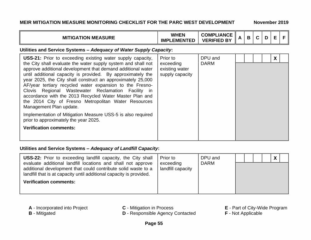
MEIR MITIGATION MEASURE MONITORING CHECKLIST FOR THE PARC WEST DEVELOPMENT November 2019
MITIGATION MEASURE WHEN
IMPLEMENTED COMPLIANCE VERIFIED BY
A B C D E F
A - Incorporated into Project C - Mitigation in Process E - Part of City-Wide Program B - Mitigated D - Responsible Agency Contacted F - Not Applicable
Page 55
Utilities and Service Systems – Adequacy of Water Supply Capacity:
USS-21: Prior to exceeding existing water supply capacity, the City shall evaluate the water supply system and shall not approve additional development that demand additional water until additional capacity is provided. By approximately the year 2025, the City shall construct an approximately 25,000 AF/year tertiary recycled water expansion to the Fresno-Clovis Regional Wastewater Reclamation Facility in accordance with the 2013 Recycled Water Master Plan and the 2014 City of Fresno Metropolitan Water Resources Management Plan update.
Implementation of Mitigation Measure USS-5 is also required prior to approximately the year 2025.
Verification comments:
Prior to exceeding existing water supply capacity
DPU and DARM
X
Utilities and Service Systems – Adequacy of Landfill Capacity:
USS-22: Prior to exceeding landfill capacity, the City shall evaluate additional landfill locations and shall not approve additional development that could contribute solid waste to a landfill that is at capacity until additional capacity is provided.
Verification comments:
Prior to exceeding landfill capacity
DPU and DARM
X

Chapter Five
List of Preparers and Persons
Consulted

Parc West Development Project | Chapter 5
CITY OF FRESNO| Crawford & Bowen Planning, Inc. 5-1
LIST OF PREPARERS AND CONSULTATIONS
List of Preparers
Crawford & Bowen Planning, Inc.
• Travis Crawford, AICP, Principal Environmental Planner
• Emily Bowen, LEED AP, Principal Environmental Planner
Persons and Agencies Consulted
City of Fresno
• Will Tackett, Planning Manager