institute of sciences - pêches et océans · pdf fileseveral shore-based surveys...
TRANSCRIPT


Institute
of
Ocean
Sciences PATRICIA BAY, SIDNEY, B.C.
I ..... Government Gouvernement ..... of Canada du Canada

For additional copies or further information, please write to:
Department of Fisheries and Oceans Institute of Ocean Sciences, Patricia Bay P.O. Box 6000 Sidney, B .C. CANADA V8l 4B2

1980 ANNUAL REPORT Institute of Ocean Sciences


Contents DIRECTOR-GENERAL'S FOREWORD 7
DEPARTMENT OF FISHERIES AND OCEANS 9 Hydrography 11
Field Hydrography 13 Chart Production and Distribution 17 Tidal and Current Surveys 19 Engineering Services 21
Oceanography 23 Ocean Physics 25
Coastal Zone Oceanography 26 Frozen Sea Research 31 Offshore Oceanography 35 Numerical Modelling 43 Remote Sensing 45
Computing Services 47 Ocean Chemistry 48 Ocean Ecology 58 Ocean Information 61
Ships 63 Management Services 69
DEPARTMENT OF THE ENVIRONMENT 73 Atmospheric Environment Service 75 Canadian Wildlife Service 77
DEPARTMENT OF ENERGY, MINES AND RESOURCES 79 Earth Physics Branch & Geological Survey of Canada 81
Chief Scientist's Foreword 81
Seismological Service 82
Earth Structure by Seismic Methods 85 Geothermal Studies 86 Geodynamics 8 8

Gravity Geomagnetism Geological-Geophysical Studies S edimen tology
APPENDICES I. Contracts Awarded during 1980/81
II. Publications III. Permanent Staff, 1980
89 90 92 93 99 99
101 108

Director-General's Foreword
This annual report is intended to provide a general overview of activities at the Institute of Ocean Sciences during 1980, the first year for which all departments and sub-divisions have joined in producing a single, comprehensive outline of our work.
One of the more fortunate events of 1980 was a decision by the Atmospheric Environment Service to second a senior research scientist here, to work with our staff on problems of mutual interest. The first such co-operative endeavour was the Storm Transfer and Response Experiment, field work for which was completed during the year; it is more fully described later in this report. It is my hope that this initial step will lead to the development of a meteorological component at the Institute, since our oceanography programs are already closely linked with meteorological problems.
During the year, formal reviews of our Oceanography and Hydrography programs were conducted by outside review groups. These outside groups have provided perspectives which can not be obtained through internal review processes. Their conclusions will be used to develop the Institute's staff, and in planning our program strategy. We intend to continue with such reviews .
1980 also saw the formation of the Ocean Information Division, which was established to provide reviews and advice to agencies concerned with protection of the environment. In addition, this new division will generate raw data and printed materials, such as atlases . It is our further intention that the Ocean Information Division anticipate marine environmental problems, providing the necessary overview and assessment before situations become urgent. For example, work has already begun on a study of marine environmental problems in the Beaufort Sea, which has been targeted for extensive oil exploration. All activities of the Ocean Information Division will be based on the expert advice of our research staff.
The Pacific Region of Ocean Science and Surveys was reorganized in 1980, following the retirement of several directing staff members. Our organization is now based on the principle that technical facilities should be operated by the divisions which are their primary users, and should not be centralized. Accordingly, Ships and Electronic Services have been placed under the Director of Hydrography, and Computing Services under the Head of Ocean Physics.
Perhaps the most gratifying development of the year, from a director's point of view, has been the spontaneous emergence of joint research
7

8
among scientists from various departments here at lOS . It is this kind of co-operative research which the Institute was created to foster; to see it developing is reassuring, and augurs well for the future .


Hydrography
11

12
Pm/lh R('guJ/1 ICJX() Illdrogrtlpim HIn'!'\ program
ICJXfJ programme c/(, le\"e� 111 drograpluqIH'\ dc' 10 regWfJ dll PO( IfjqlU'
Pacific Region 1 980 hydrographic survey program.

The main objective of the Hydrographic Division is to provide accurate, timely bathymetric and navigational information in the form of nautical charts, tide tables, and sailing directions for all types of userscommercial shippers, fishermen and recreational boaters. Additional data are provided to other federal government agencies, engineering and consulting firms, universities, environmental groups, and the general public.
The Division carried out three major activities during 1980: surveys of the Beaufort Sea and associated development projects; a reorganization of the Chart Construction group; and participation in the Coastal Ocean Dynamics Experiment (CODE) .
A design contract for a vessel to replace the CSS William ]. Stewart was let to a Vancouver firm of naval architects. Special funding provided for a long-range positioning system, an onboard computer, new echosounders, and digitizers to refurbish the aging hydrographic equipment.
In October, a formal program review and evaluation of hydrographic activities was carried out by an independent review team comprised of representatives from industry, universities, and other government agencies. This was the first of its kind for lOS hydrography, and proved both informative and constructive.
Field Hydrography Field Hydrography is responsible for conducting hydrographic surveys
of B.C. coastal, western Arctic, and navigable inland waters of the Pacific Region, in order to ensure that requirements for navigational information are met. Alterations of and additions to traffic routes, types and sizes of vessels, harbours, bottom topography and coastlines- all these require an ongoing survey and resurvey program.
Barge Pender and launches in Barkley Sound.
•
13

14
The barge, Pender, designed primarily as a tender for the submersible, Pisces, was assigned to hydrographic field surveys for the first time during a three-month period in 1980. It was towed to the Broken Group in Barkley Sound on the west coast of Vancouver Island in late April. The Broken Group area was last surveyed, by lead line, in 1931 . These waters are now part of the Pacific Rim National Park. In addition to steadily increasing recreational activity, there are several channels for coastal commercial traffic in Barkley Sound. After this project was completed, the survey party moved to Okanagan Lake for the balance of the season. (For additional information regarding these surveys, contact G.E. Richardson.)
Work was also conducted from the CSS Richardson in the Queen Charlotte Islands, in areas last surveyed early in this century. Surveys of Masset Sound, McIntyre Bay and Virago Sound were completed. Naden Harbour and an area in Dixon Entrance between Seath Point and Wiah Point were resurveyed. Some preliminary work was done in Skidegate Inlet, the new terminal area for the B,C. Ferry Service to the Queen Charlotte Islands; a complete resurvey is scheduled for 1981 . (Contacts: M. V. Woods and C.R. Tamasi. )
While in northern waters, the Richardson party assisted federal Ministry of Transport (MOT) personnel investigating the loss of the ore freighter, Lee Wang Zin. The Richardson surveyed Celestial Reef in Dixon Entrance, in order to confirm its precise location and depth.
Several shore-based surveys were carried out on the B.C. coast to assist planning for new charts . Coverage of a large area near Swartz Bay was further extended for a proposed new chart. Areas in the vicinity of Campbell River and Cowichan Bay were resurveyed at the request of MOT. The Pacific Pilotage Authority asked that Romulus Rock in Porlier Pass be resurveyed. As well, an area around Patey Rock in Satellite Channel was resurveyed in order to resolve conflicting data.
Pandora II, a charter vessel, left for the western Arctic at the end of June . Although an early entrance to the Beaufort Sea was achieved on July 18, ice conditions hampered survey operations for the entire season. In early September it was decided to leave before the western exit to the Beaufort Sea was closed by ice. Unfortunately, the vessel developed steering problems, which meant returning to Tuktoyaktuk for repairs . By the time these were completed, passage out of the Arctic had to be made eastward via the Northwest Passage, since there was no icebreaker support to assist a westerly departure around Alaska. The voyage ended at the Bedford Institute of Oceanography (BIO) in Dartmouth, Nova Scotia. (Contact: A.D. O'Connor. )
The CCGS Bernier ran profile track soundings in Minto Inlet and Prince Albert Sound for potential beach landing sites. (Contact: ].A. Vosburgh.)
Aerial surveillance of artificial oil drilling islands in the Beaufort Sea continued during 1980; the future of this program is under evaluation.

The Navigation Group tested a Minifix positioning system on the Pandora II in case a new system planned for the HUDSON '81 hydrographic surveys in the Beaufort Sea next year is not available. The Navigation Group also provided support to the Pacific Geoscience Centre (PCG) by collecting bathymetry for resource charting surveys off Dixon Entrance, using the BIONAV data collection package.
Hoisting a Minifix mast at Pullen Island, N. W. T.
The Navigation Group also entered a cooperative venture with Dome Petroleum Limited and the federal MOT to assess Loran-C Accufix systems as possible navigational aids to tanker traffic in western Arctic waters. (Contact: A.R. Mortimer.)
Surveys for revised charts and sailing directions in the Fraser River, Vancouver Harbour, the Strait of Georgia, and for charts covering all of Vancouver Island, were carried out under contract.
A great deal of planning has gone into the hydrographic phase of the HUDSON '81 expedition. One of the major projects to be undertaken is a corridor survey through the Pingo-Like Features (PLF) area of the Beaufort Sea. Pingos are known to exist in depths of 20-100 m off the Tuktoyaktuk Peninsula. They are a major navigational hazard to the deepdraught tankers which are expected to transit the Beaufort Sea in the forseeable future. The traffic corridor being planned is ten miles wide and 170 miles long; it will take several seasons to complete all survey work. The first surveys will be done by the CSS Hudson with hydrographers from the Pacific Region in charge, assisted by staff from headquarters and the other regions .
15

16
Sailing Directions
The Sailing Directions Section maintains two volumes each of sailing directions and small craft guides for the B.C. coast. New editions of these double volumes are published every other year.
The third edition of B. C. Small Craft Guide: Volume 1I, Boundary Bay to Cortes Island was published in July. Sailing Directions for Kootenay Lake and River, a strip chart with directions in book format, was published in May. A new edition of B. C. Sailing Directions (North Portion), Volume II is in the final stages of preparation and will be published in 1981 . It will be followed by a new edition of B.c. Small Craft Guide, Volume I: Vancouver Island, Port Alberni to Campbell River, including the Gulf Islands.
Hydrographic Development
Preparatory work was undertaken for acquisition of a new computer and associated equipment to be installed aboard the Hudson for the 1981 Beaufort Sea survey program. Software packages for general survey and Loran-C computations on the HP9825 computer were completed and documented. Other activities included: revised sounding selection algorithm for the hydrographic data processing package; restructuring of plotting routines for survey lattices; and incorporation of B .C. provincial data for the Okanagan Lake survey.
Coastal and shoreline features from recent topographic maps at a scale of 1 :5 ,000 were redrawn at the survey scale of 1 :40,000, using the automated cartographic plotting system. A minimum of field work was required to verify the quality of the data, resulting in a considerable saving of time when compared with a conventional survey of the entire area.
Work continued on the Aerial Hydrography Project at the Canada Centre for Remote Sensing in Ottawa. In conjunction with the Central Region, ground control points were established for a photo mission along a portion of the Bruce Peninsula on Lake Huron. This contract has been completed; recommendations for future activity are under review.
During the year, two international hydrographers, Mr. Hideo Fukaya representing the Japanese Hydrographic Association, and Lieutenant Garcia from the Portuguese Hydrographic Institute, visited lOS to examine the hydrographic data system in use for the Pacific Region.

Chart Production & Distribution Chart Production and Distribution have two major functions: to
process survey and other data into new charts and publications as quickly as possible; and to ensure that an adequate stock of corrected charts is readily available for all users of Canada's navigable waters, as required by law.
The regional program includes the compilation, drafting and distribution of nautical charts. In Chart Production, emphasis is being shifted from New Editions to New Charts, reflecting an accelerated conversion to a standard metric/bilingual format. The Distribution Section is planning more aggressive promotion of charts and publications, to increase public awareness and use of them.
By mid-1980, Chart Production was near full strength for the first time since decentralization was initiated. A reorganization of the production units now ensures training and development of cartographers in every area. Cartographers in each unit are required to take turns preparing new charts, editions and reprints, and using automated equipment.
Due to the lead time required for the production of new charts, the impact of the decision to shift from chart maintenance to new chart production will not become evident for several years. Extensive work is underway in developing chart schemes and formats for the western Arctic, and in new proposals for coverage of the Queen Charlotte Islands. Minor changes for large areas adjacent to Johnstone Strait are also being considered.
Four new Pacific Region Charts were produced in 1980, three by the Region and one at Headquarters. In addition, 49 new editions (including one by Headquarters), 45 reprints (24 by Headquarters), three overprints,
. six patches, and 96 notices to mariners were completed.
Cartographer's Digitizing Station.
17

18
The past year has seen relatively few development changes in Automated Cartography. One new Headquarters program, SYMBOL, and three regionally-developed programs, MOSCHK, PLACES and STAR 2 , have been added to our system. An AL TEK digitizing table has been ordered; delivery is expected in 1981 .
Participation in the CHS Carto I Course, and rotation of all cartographic staff through the photo-mechanical unit continued with good results. Assistance has also been offered to the new cartography program at Camosun College, Victoria . Chart Production will provide the college with guest lecturers, equipment, materials, and assistance with projects.
The number of documents now stored by the Technical Records Unit is approximately 30,000 . One of the primary tasks of the Nautical Information Officer and the Technical Records Clerk is the collection of data from every possible source. The increasing demand for nautical information, especially Notices to Mariners and Notices to Shipping, has resulted in the appointment of a temporary assistant to the Navigation Information Officer. A close rapport continues with the Canadian Power Squadrons, which submitted 450 MAREP reports. These; in combination with information from numerous other sources, contributed to 1,630,339 corrections to 272,981 charts completed by contract in 1980 .
During 1980, the Chart Distribution Office expanded its program of advertising new charts and publications to authorized dealers and the boating public. A computerized system for informing dealers of new printings and other products was instituted, along with a new Chart Dealer Poster, 23 new sales outlets and 11 small craft guide dealerships were added to the distribution network in 1980 . Pacific Region distributed 196,579 charts, 84,601 publications, and 8,157 free pamphlets and brochures.
1.0.5. Retail Sales Office.

Tidal and Current Surveys This program provides tidaL current and water level data, along with
other information and expertise, for the Canadian west coast and western Arctic. Instrument field networks are maintained for operational and research purposes.
The past year marked the end of field operations for tides and currents in the Coastal Ocean Dynamics Experiment (CODE) off the west coast of Vancouver Island. All but one of 15 offshore, and seven near-shore moorings were recovered. However, the task of analysing some 175 data records from current meters and bottom-mounted pressure gauges, spanning about 16 months, continues . The successful use of pinger batteries built at lOS, with a life in excess of two years, has also been demonstrated. (Contacts: W. Crawford and 5. Huggett,)
During the Storm Transfer and Response Experiment (STREX) in October, 16 buoys for measuring current shear, salinity and temperature were deployed from CSS Parizeau for participating Canadian and American agencies. (Contact: 5. Huggett,)
A current meter was installed at Race Rocks in the Strait of Juan de Fuca near Lester B. Pearson College, which carries out marine biology studies in that area. The records obtained will result in predictions for Race Passage, to be included in Volume 5 of Canadian Tide and Current Tables. A study of entrainment processes, in conjunction with the University of Washington, and mathematical modeling of the Fraser River and its salt wedge, are both continuing.
Final tests of airborne electronic oil spill markers were carried out in the Strait of Juan de Fuca, in co-operation with the Remote Sensing Unit of lOS . These markers were parachuted onto the sea surface and monitored from an aircraft in order to map surface currents . This technology is now being commercially marketed in Victoria. (Contact: A. Ages.}
Data collection and marigram processing from permanent and temporary tide gauges continues. The permanent gauge in Vancouver Harbour was suddenly discontinued by construction work. It was replaced with a temporary gauge, resulting in a minimum interruption in one of our longest tidal data series . A new gauge on Ballantyne Pier, Vancouver, will be operational in 1981 .
Temporary gauges were placed at Gold River, Tahsis and Zeballos for a co-operative project with Pacific Geoscience Centre (PGC) to determine possible tilting of Vancouver Island.
Eleven pressure gauges placed in the western Arctic's Coronation Gulf, Queen Maude Gulf and St. Roche Basin in 1979 were recovered in
19
20
the summer of 1980. The gauges were used to record water level and barometric data, which are currently being interpreted.
Diving Unit
Staff members at the Institute of Ocean Sciences provide a diving service in support of Institute programs, in addition to performing their regular duties . Only those possessing the desire to dive, the necessary mental and physical capabilities, and the proper training are permitted to carry out diving operations. Such operations have become an integral part of most modern oceanographic establishments.
In 1980, over 150 dives were made on the Pacific Coast and in the western Arctic, which is comparable to the preceding year. lOS divers assisted in the deployment of three Controlled Ecosystem Enclosures (CEE) in Patricia Bay, near the Institute. Seven Institute divers, assisted by three contract divers, participated in this successful launch. The Diving Unit was also involved in: deploying and recovering numerous pressure gauges and moorings for the Coastal Ocean Dynamics Experiment; taking sediment cores; testing new current meter systems; and conducting ship hull inspections, some in western Arctic waters. (Contact: F.E. S tephenson. )
Tsunamis
Systematic efforts are being made in Canada and other Pacific Rim countries to provide earlier and more accurate warning when a threatening tsunami has been generated in the Pacific Ocean. Attention is being given to educating the public about the impact that tsunami waves may have on coastal areas, and the need for evacuation when warnings are issued. Instruction is provided to civil agencies responsible for dealing with a tsunami emergency.
These subjects were major agenda items at the 1980 meeting in Chile of the International Coordination Group for the Tsunami Warning System in the Pacific. Locally, the British Columbia Earthquake and Tsunami Working Group sponsored a seminar for the Association of Vancouver Island Municipalities, to inform civic officials of the tsunami and earthquake problems for which their communities need to be prepared. A command post exercise was conducted to test tsunami watch and warning procedures.
In addition to participating in these operations, the lOS Tsunami Unit has continued to develop its research base. During 1980, visits were made to tsunami research institutions in several Pacific Rim countries .
A historical study and computer record of tsunamis in the Pacific is being co-ordinated on behalf of the International Tsunami Information
Centre. The statistical basis for forecasting frequencies and magnitudes is being improved. (Contact: S. Wigen.J
Engineering Services Engineering Services provide electrical, mechanical and technical
support for survey, research and ship operations conducted by the Institute.
Electronic Engineering Group
1980 saw the completion of a computerized carbon dioxide gas analyser system. The first major phase of the Acoustic Doppler Current Profiler was completed, and the instrument was used to gather oceanographic data in Knight Inlet and Georgia Strait. SAIL, a system which provides detailed real-time ship's data to scientific users, was successfully tested on CSS Parizeau. A shipboard data logging system and acoustic navigation package for the submersible, Pisces IV, and a depth digitizer for the HUDSON '81 program were developed by contract.
This year, too, the Electronic Engineering Group undertook a variety of hydrographic projects in conjunction with the High Arctic Research Program, including the development of a side-scan sonar, study of a sidetow sounding system, and a variety of data processing developments.
Technical Support Group
During 1980, this group was involved in the Pandora II western Arctic . survey and several west coast surveys, including Barkley Sound with the Pender, and northern Queen Charlotte Islands with the Richardson. Shore parties were also conducted at Okanagan Lake, Campbell River and the Sidney-Swartz Bay area.
Other projects included: the design and construction of two uninterruptable power supplies; modifications to Mini-Fix in preparation for Arctic trials; fitting out the launch, Nucleus, for the Barkley Sound survey; installing a third radio station in the Pender for hydrographic purposes; preparations for HUDSON '81; and equipment acquisition and evaluation. Adaptation of low-cost commercial fishing echo sounders to hydrographic purposes is under contract.
21

22
Mechanical Support
This group provides machining and fabricating facilities, in addition to engineering design assistance for 105. Projects vary from repairs and modifications to the design and construction of prototype devices. 1980 achievements include:
trace metal seawater sampler (for Ocean Chemistry) component parts for CTD (conductivity, temperature, depth) winches (Frozen Sea Research Group)
- hydraulic piston assemblies (Ship Division: Pisces IV)
- aluminum core masks (Ocean Chemistry) pressure transducer connector and penetrator (Ocean Ecology) PVC seawater samplers (Ocean Ecology)
pressure vessel for diving gauge testing (Tides and Currents) .
Industrial Liaison and Contracting
The Institute of Ocean Sciences has an established policy of conducting a significant portion of its program through contracts to the private sector. Liaison and support for contracting activities is conducted by the administrative staff of the Engineering Services Group. The level of contracting activity did not quite achieve the $2.2 million level of 1979. However, expected increases in the Ministry of Transport-administered High Arctic Research Program (Hydrography) and 105 participation in the National Research Council's Program for Industry/Laboratory Projects (PILP) suggest a possible 15-20% increase in contract activity for 1981/82 . (Contact: ] . V. Watt,)

Oceanography
23


The oceanographic program includes ocean physics, ocean chemistry and ocean ecology. The Institute of Ocean Sciences is responsible for conducting research and providing advice in many areas, including: ocean processes, operations in ice-covered waters, ocean resources, marine pollution, and the ocean's influence on climate and the effect of that relationship on human activities .
The oceanographic program contributes to the development and transfer of ocean technology, the provision of ocean information, ocean data management, and to marine research at universities and other institutions throughout the world. Areas under study include coastal, shelf and offshore waters of the Pacific, as well as a significant portion of the western Arctic, including the channels of the Arctic Archipelago.
Ocean Physics During 1980 it became apparent that the Institute as a whole, and the
Ocean Physics Division in particular, had reached an exciting new stage. Mutually beneficial working relationships between members of different groups are become the rule, so that projects involving only members of Ocean Physics have become rare. Such relationships extend outside the Institute, to other Canadians and scientists around the world. The resulting exchanges have had a stimulating effect on all those involved, and this has in turn communicated itself to the rest of the staff. The end result is a more lively intellectual atmosphere than was previously evident.
A list of major accomplishments during the year would certainly include: the successful completion of the polynya experiment to measure heat transfer through open water areas during the Arctic winter; the conclusion of the main part of the study of the continental shelf off Vancouver Island; and the completion of the observational phase of the
. Storm Transfer and Response Experiment (STREX) around Ocean Weather Station P (sooN, 14SoW) during a suitably stormy November and December.
The primary objectives of the Ocean Physics program are to describe and understand physical properties, processes and other phenomena in estuaries, coastal seas and marine waters, on the continental shelf and offshore, in both open and ice-covered areas. Activities are designed to provide expert physical oceanographic information and advice to meet Canadian federal responsibilities, with particular emphasis on the west coast and the western Arctic.
25

26
Coastal Zone Oceanography
The major aim of the coastal oceanography program is to advance our understanding of coastal ocean dynamics, and of mixing processes and their consequences. Phenomena investigated include: tidal interaction with fjord sills; generation, propagation and decay of non-linear internal waves; and the structure of free shear layers and mixing processes in a saltwedge estuary. Studies of currents and water properties on the continental shelf are conducted to increase our knowledge of seasonal and short-term dynamics (upwelling, coastal currents, long internal waves, etc.), as well as shelf water interaction with shore and inlet waters.
Continental Shelf Study
The main experimental effort of Coastal Zone Oceanography was directed to the line of seven stations extending from the continental shelf break into Alberni Inlet . A regular pattern of CTD stations and five current meter locations have been maintained off the west coast since the spring of 1979. These serve to describe the annual cycle of currents and other hydrographic properties on the southern British Columbia continental shelf.
A low oxygen event first observed in the 1979 study recurred in 1980 and was thoroughly surveyed in both space and time. This feature appears to be closely associated with a large cyclonic eddy that occurs on the southern Vancouver Island continental shelf every summer. The shelf is deeply cut by a narrow canyon, which is in such a position that the eddy induces an inward pressure gradient. We hypothesize that this gradient allows deep water to flow from depths of around 350 m at the edge of the shelf, up along the canyon bottom to the continental shelf.
The current meter aspect of the program has proceeded well. Data return for 1980 is well over 90%, and preliminary analysis shows that the flows over the shelf are complex. However, regularity can be seen at low frequencies, and an understanding of a flow pattern is emerging. The summer current pattern is consistent with the motion of the cyclonic eddy mentioned above. We have verified that locally-driven upwelling indeed occurs at this latitude, and that the intensity of upwelling is in fair agreement with theory. However, the rate of upwelling indicated by theory and experiment is not sufficient to account for the volume of dense water that appears on the shelf each spring. (Contact: H.]. Freeland. )

+100
19)4 20/5 5/7 25/6 14/10
� 80 . � _ ____ il! /\ i 100�' l)) 120 / / \
Di.'1.mh'ed orJ'!�en concentration (mIll) at station 105 (mid-sltelf)
Time series of dissolved oxygen concentration (in mill) versus depth at a single Coastal Zone Oceanography Station on the continental shelf off Barkley Sound, through 1 9 79 and 1 980 .
The annual signal is dominated by a period of extremely low dissolved oxygen values through the summer period. The time of onset of the feature (in 1 9 79) does not appear to be closely related to any specific event in the weather record, above the contour plot; but the time of collapse appears to be close in time to the occurrence of the first major storm of the winter.
The plot above is a Bakun Upwelling Index of 4 8 °N. This is an estimate from geostrophic winds of the magnitude of the coastal wind field. Specifically, it is the computed transport offshore in the surface Ekman layer in m3/secl 1 00 m of coastline length .
Alberni Inlet Circulation Study
A related program which includes two additional meters extends from Barkley Sound into the Alberni fjord system. CTO and oxygen data were collected on a series of cruises at about six-week intervals. The shelf water appears to play a major role in the renewal of deep basin water, resulting in nearly complete replacement annually. This was confirmed once more by the 1980 data defining the water structure, although the periods of strong steady inflow of deep waters observed in 1979 were not so much in evidence.
A decrease in oxygen content was observed, following an initial increase, as dense water continued to flow into the fjord. Above sill depth at the outer basin mooring, strong (0.4 m/s) and frequent (3-10 days) exchanges of water between fjord and shelf were observed,
27

100
200
100
28
30
especially during the late fall and winter months, when the frequency and intensity of weather disturbances are greatest. These exchanges appear to be controlled by the offshore wind field, since the direction of the exchanges is correlated with upwelling indices for the adjacent region. Changes in the shelf density structure produced by wind stress cause a rapid readjustment to the fjord density above sill depth. Plans are presently underway to construct a numerical model of shelf-fjord interaction. (Contacts: W.H. Bell and D.]. StucchU
DISTANCE FROM HEAD (nautical ml) 20 10
___ AUg.22.1979� �oct..4,\g �
ALBERN I INLET SYSTEM
!showlno mOllmum cha"",' ckpth 1
toO
300
400
DISTANCE FROW HEAO (nauticol Inl) 30 20
___ Aug. 12.1980--___ _
100 �June 13.1980--
10
100
This figure shows sequential positions of an isopycnal (OT = 2 5 . 4), indicating the annual cycle of density changes in the deep outer basin of Alberni Inlet, B . C. The gradual descent of constant density surfaces through fall and winter, and the relatively rapid uplift in late spring, are readily apparent.
AIHrIti '.1" S 200
100 ALBERNI INLET
SYSTEM
zoo'" !
300
400

Acoustic Velocity Sensor
A sonar device for remotely sensing currents at depths to a few hundred metres has been built and tested. The system uses the range gated Doppler technique, although other approaches are also being considered. In its present configuration, the 100 KHz transducer is mounted on a steerable platform at the base of a ship-mounted mast; data have been collected with the ship both travelling and stationary. Several tests in Knight Inlet and Saanich Inlet confirm the feasibility of the approach, while also emphasizing some of the technical difficulties such as the generation of suitable beam patterns. Development of a more advanced transducer operating at 200 KHz with a much narrower beam and lower side lobes is presently underway. (Contacts: D.M. Farmer, and ]. Galloway of Institute Electronics.)
Knight Inlet Circulation Study
Study of the circulation of Knight Inlet continued this year in conjunction with Dr. Pond, University of British Columbia, using the automatically profiling Cyclosonde current meters. Velocity profiles were obtained simultaneously with the range gated acoustic Doppler system to permit comparison of the two techniques.
Analysis of data obtained in previous years is permitting calculations of non-linear internal wave trains generated at the sill. In particular, it has been shown that energy lost from the waves is just sufficient to account for changes in both density and velocity profiles in the fjord over the 20 km that the waves could be tracked. (Contact: D.M. Farmer.)
Lake Circulation in Winter
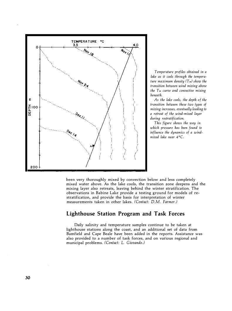
An analysis of re-stratification in a lake during winter, when it is below the temperature of maximum density, has explained the existence of several features observed in Babine Lake. An equation of state that includes the effect of pressure on the density structure shows that just below 4°C, during periods of cooling and wind mixing, a transition depth must exist, separating a zone of forced convection near the surface from free convection beneath. Mixing across this layer can occur through a conditional instability in which a downwards movement of initially stable stratified water can become unstable, resulting in convective mixing to the lake bottom. It is shown that, as the lake cools, this transition depth must increase.
A review of data collected in Babine Lake has provided direct evidence of this transition zone which marks a change between water that has
29
E
�IOO 0-w o
200
30
'.
Temperature profiles obtained in a lake as it cools through the temperature maximum density (T m) show the transition between wind mixing above the T m curve and convective mixing beneath.
As the lake cools, the depth of the transition between these two types of mixing increases, eventually leading to a retreat of the wind-mixed layer during restratification.
This figure shows the way in which pressure has been found to influence the dynamics of a windmixed lake near 4 °C.
been very thoroughly mixed by convection below and less completely mixed water above. As the lake cools, the transition zone deepens and the mixing layer also retreats, leaving behind the winter stratification. The observations in Babine Lake provide a testing ground for models of restratification, and provide the basis for interpretation of winter measurements taken in other lakes . (Contact: D.M. Farmer.)
Lighthouse Station Program and Task Forces
Daily salinity and temperature samples continue to be taken at lighthouse stations along the coast, and an additional set of data from Barnfield and Cape Beale have been added in the reports. Assistance was also provided to a number of task forces, and on various regional and municipal problems. (Contact: L. Giovando. )

A watching brief was continued on developments in mooring technology and related aspects, such as drag and vibration problems. Assistance with mooring design was provided to other groups in the Institute. A watching brief was also maintained on the physical aspects of ocean dumping. (Contact: W.H. Bell,)
Frozen Sea Research The Arctic physical oceanographic program concentrates on under
standing processes operating in Arctic fjords and inlets, the Arctic heat budget (including air-sea-ice interactions), 'and the dynamics of the Arctic Ocean and channels of the Arctic Archipelago. The major objectives are to provide advice and information to government departments, Arctic industry, and the public for design and marine regulatory purposes.
Polynya Experiment
The third year of field study of the Dundas Island Polynya (76°08'N, 95°00'W) was completed during March and April, in co-operation with groups from the Bedford Institute of Oceanography and the Atmospheric Environment Service, Downsview, Ontario. Measurements were made of mean velocity and temperature profiles in the atmosphere, upstream and downstream of the polynya, together with records of the fluctuating components of velocity and temperature. Independent, preliminary analyses by all the groups involved indicate that sufficient data has been obtained
. to assess heat loss from the polynya over a wide range of conditions. Oceanographic data were obtained from four Aanderaa current meters
placed 12 m below the ice to record current speed and direction, water temperature, and conductivity for a period of 34 days. Complete data sets were recovered from all instruments. A preliminary analysis indicates a strong temperature signal in the water mass closely correlated with tidal flow, there being roughly a O .pC temperature difference between tidal flows in opposite directions . A workshop involving all three participating scientific groups is planned early in 198 1 . (Contacts: E.L. Lewis and R. L. Lake.)
31

32
;;: 3!l. a: o .....
�Z!l.
o UJ � l!l. '"
BU�Y 2447
!l. I 36!l.
\a- -==--------1 "\I
' " Z7!l.
z Ie
� . / 1 " •
;: le!l. LJ UJ II! 9!l. o
� "' " . II " . ". .
� ,;
\..,..; V "V �, 0.1 ..
337.6!l 34!l.O!l 34Z .6!l 346.0!l 347.6!l TlMEtORYSJ
;;: 3!l. a: BU�Y 2447 o .....
�Z!l.
o UJ UJ l!l. ll;
0.. VY
36!l.
Z7!l. z ID ;: lS!l.
•
I I ""'"
" LJ UJ II! C 9!l. rJ
o. I • '" ' ,
"V
i ' ,. ' 34Z.6!l i
34-6.0!l
;;: 3!l. a: BU�Y 2447 o .....
�Z!l.
o UJ �l!l. II)
!l. v �
Z Ie
36!l.
Z1!l.
;: le!l. LJ UJ II! C 9!l.
.
v� ·
A /1. �"tIj�
'iI
• � I � : � o. I , . , " . 'ir i i i 337.6!l 34-!l .O!l 34-Z .6!l 346.0!l
TlMEtDRYSJ
3SC.O!l

Beaufort Sea Oceanography
All the four Beaufort Sea CTO profiles acquired in November, 1979, have been analysed, and a new field operation has been planned for March, 1981 . The 1979 data has defined the baroclinic flow with respect to the 400 decibar level at a coarse spatial resolution (approximately 100 km) . Over the continental slope, the baroclinic current is about nine cm per second, twice the current offshore. Outflow from the Amundsen Gulf was demonstrated by the baroclinic calculation, and by the existence of a sub-surface temperature maximum distinct from the Bering Sea water which was identified in the Amundsen Gulf and along the slope north of Tuktoyaktuk.
Information on currents on the shelf is very limited, and bottommoored meters are liable to be destroyed by moving ice. For this reason, work was initiated using the positions and relative current measurements of satellite-tracked buoys equipped with current meters as they moved with the ice . Elimination of higher frequencies with the use of KalmanFilter techniques shows great promise in enabling computation of currents at mid-depth (approximately 20 m). The group is involved in the preparation of a definitive statement of southeastern Beaufort Sea oceanography. The early stages involve a compilation and critical appraisal of all existing data . (Contacts: H. Melling and A. Cornford.J
Speeds and directions of ice drift and water movement, measured during the Beaufort Sea Winter lee Experiment in late 1 9 79 . Data were received via satellite from a buoy, and from a current meter drifting freely with pack ice at a depth of 20m.
Careful processing of the data permitted an estimate of the ice drift (top of chart), the water flow relative to the moving ice (centre), and the actual current (bottom). An ice-moored current meter permits current measurement at shallow depths in the A rctic, where a bottom -moored meter would be destroyed by moving ice. (Data courtesy of Canadian Marine Drilling, Ltd.)
•
Bridport Inlet
The survey of Bridport Inlet (75°N, 108°W) continued, in order to provide sufficient additional data for testing a circulation model. This is the proposed site of a liquid natural gas tanker terminal for the Arctic Pilot Project. Initial evidence iridicates that water movement in the entrance to the inlet appears to be considerably more complex than had been anticipated.
33

34
Oil Well Blowout Studies
Studies of the physics of deep oil well blowouts continue . The work carried out under contract by the University of Calgary on hydrate formation in natural gas bubbles formed in such a blowout has been completed. Further independent work under their post-graduate studies program has provided data on the rate processes controlling the formation of gas hydrates under a wide variety of conditions . This information has been incorporated into a mathematical model of rising bubbles which gives reasonable quantitative agreement with experimental results.
The model predicts the radius of a gas bubble as a function of time from release under specified conditions. There is a critical release depth from which a bubble just reaches the surface, and this has been used in comparing theory with experiment. These calculations can be extended to predict the behaviour of the entire bubble plume, hence to define more closely depths below which blowouts will not cause large-scale vertical circulation in the water column . (Contact: D. Topham.)
Technical Development
Construction of the "salinity sucker", a device for measuring ice crystal contact and supercooling in seawater, was completed and deployed in conjunction with the polynya field operation. Conditions in the polynya and in Wellington Channel were different from those recorded in previous years; no ice crystals were found at lower depths and there was no supercooling. A more sophisticated, less cumbersome version of this device will be constructed in the future. Work on salinity chains has continued by testing various commercial embodiments of conductivity cells . An excellent cell design now seems to be available and two of the commercially available chains have been ordered for field testing next year.
Analytical field and laboratory experiments enabled faults in our original sonically oriented current meters (SOCMS) to be identified; a contract to produce an improved version has been let. Much effort has gone into the design of an airborne CTD system speCifically engineered to fit into a Twin Otter aircraft. This system will enable CTD profiles to be taken at a depth of 1200 m, with sufficient data processing in real-time to enable on-site judgement. There has been an accent on redundancy in the design; spares for most of the equipment and recording systems are immediately available. (Contact: E.L. Lewis.)
The Practical Salinity Scale 1978 has now been adopted by all major international oceanographic organizations, and is recommended for exclusive use in reporting all salinity data commencing January 1, 1982 . This completes our contribution over the past five years.

Membership in IAPSO/SCOR WG 51 on the Interpretation of CTD data has resulted in the production of a final draft of "Design of CTD Observational Programs in Relation to Sensor Time Constants and Sampling Frequencies," our part in the writing of an international manual. It has become apparent that further refinement of CTD data processing procedures in the laboratory is desirable. Other researchers have suggested that our work may have some general use in improving the quality of oceanographic observations.
The group is involved in the Eurasin Basin Experiment, a child of SCOR WG 58 on the Arctic Ocean Heat Budget, scheduled to commence in March, 1981 . Preparations are afoot for a pilot project to study the feasibility of using horizontal pressure gradients in Arctic channels in order to measure currents at depths where ice is a hazard. (Contact: E.L. Lewis.)
lOS chairs the Working Group on Northwest Passage Oceanography, a co-operative endeavour between industry, government and universities, for the study of this potentially important transport route. A general advisory service to government and industry provided comments on data collected by proponents and their consultants. Advisors also play an active role in committees such as the Arctic Marine Oilspill Program, Beaufort Sea Winter Ice Experiment, and the Technical Committee for the Cape Hatt Oil Spill. (Contact: R.A. Lake.)
Offshore Oceanography The offshore oceanographic program studies variations of the North
Pacific Ocean, in particular the distribution of ocean properties and currents, and the processes controlling them. Major areas of emphasis are: climatology and large-scale air-sea interaction; oceanography of the continental shelf; oceanic heat storage and thermal structure, and their contribution to marine weather; mixing processes and micro-structure in ocean waters; and major contributions to buoy technology for national and international programs. Inquiries are also directed towards understanding the relationship between open ocean and coastal processes.
Coastal Ocean Dynamics Experiment (CODE)
The purpose of this experiment is to provide detailed knowledge about the spatial and temporal variability of currents, winds, sea level and water properties off the west coast of Vancouver Island. The 16-month field
35
36
QUEEN CHARLOTTE SOUND 18MAY-20JUlY.1977
ST,\T10N 3
;ilr---vd\-'----'tI'-I'V"""��·*"+-"'I;H-t'\i-Mi)�-.--f"'=="'-n:If1:r'-111-1d�...J!I-rd-l'-lt-\�u�III'-4r14Ht-t--tH1hHI�tltH�"*'"'rJ ..J--:ftt,bffit-A--t+l�-itffi�t-------1 ,:,: if----: -----N-.. ,'M"-+-�-+
N
D �--"-.!
m
"'I--.I\�'I<MV�..---.t1o-"H��F--\I-.['A-N\-"t'\l+"tlNn'll'l1lrtf;lW'o.�IHtIt'
�
�l\--ft��1��i\t"\�f}�f1lW'---'6\-tj� It'iir�.,..,..,/f,,,JHf1!'.j�l� Htt-� ------1
In. s.
CURRENT AT 15m (em/sec) INERTIAL OSCILLATIONS
E_ : ;
o i 'vftoDv",Pr/\;"lr/'oO ·/'v"oc... ... "AA�nnnnMO,. 'NT:
D�'--�----��--� __ �'�� __ �----------�--__ ��� ______ � ______ ----�
::j S.
65
E1 :
CURRENT AT 160m (cm/::.ec)
O!�: --____ ��� .• �.��.� ____ ��� ________ �� __ ��--� ________________ � Wl i 65' I ! ! I I 138
I! ! I ! I I I I I ! j I I I I I , "
I ! ! I 166
I ! I I I! I ! 19·1
: : I :.'01
JULIA
N
DAY 1977
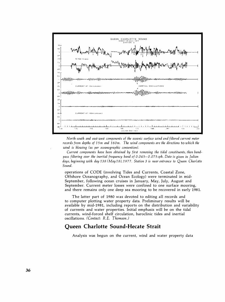
North-south and east-west components of the oceanic surface wind and filtered current meter records from depths of 1 5 m and 1 60m. The wind components are the directions to which the wind is blowing (as per oceanographic convention).
Current components have been obtained by first removing the tidal constituents, then bandpass filtering over the inertial frequency band of 0 .04 5 - 0 . 0 7 5 cph . Date is given in Julian days, beginn ing with day 1 3 8 (May 1 8), 1 9 7 7 . Station 3 is near entrance to Queen Charlolle Sound.
operations of CODE (involving Tides and Currents, Coastal Zone, Offshore Oceanography, and Ocean Ecology) were terminated in midSeptember, following ocean cruises in January, May, July, August and September. Current meter losses were confined to one surface mooring, and there remains only one deep sea mooring to be recovered in early 1981.
The latter part of 1980 was devoted to editing all records and to computer plotting water property data. Preliminary results will be available by mid-1981, including reports on the distribution and variability of currents and water properties. Initial emphasis will be on the tidal currents, wind-forced shelf circulation, baroclinic tides and inertial oscillations. (Contact: R.E. Thomson.)
Queen Charlotte Sound-Hecate Strait
Analysis was begun on the current, wind and water property data

collected jointly with Tides and Currents from May-September of 1977 in the Queen Charlotte Sound-Hecate Strait region. Those observations also included oceanic surveys of the approaches to Douglas Channel, as part of the Kitimat oil port study. Data reports are in preparation.
One of the most interesting features observed was the presence of strong wind-generated inertial oscillations in the near-surface records. The inertial current events of mid-June and mid-August, 1977, were especially vigorous with speeds in excess of 50 cm/ s, and durations of more than one week at most locations, with spatial coherences over hundreds of kilometres. Their amplitudes and phases are determined by local winds associated with eastward propagating depressions. Confinement of coastal winds by the mountainous terrain appears to account for the marked spatial variation in the inertial current patterns within the seaway. (Contact: R.E. Thomson.)
Seiches in Juan de Fuca Strait
In January and February, high resolution gauges recording at twominute intervals were installed at Port San Juan, Becher Bay, Pedder Bay and Victoria Harbour along the northern side of Juan de Fuca Strait.
SEICHE PROJECT -- FILTER, BUTTERWORTH - ORDER, 7 - FCUT< .B33300-002 CYCIMIN
"' 'jODI �Z1t PlODDER 81'1T 05 BO.A 15 111011-FILTERED. 50URR[(J 'H/O LOll-FILTERED
!: � M�A - A !\ , . �A � � � , "f\. 0 0 An NJ\ 00_ '.M.�.� �.t" or"" "i,." .a,, �"�, ••. • (I ii
�aOl 05 80.R]6 HUlK-F1LTERfII
�l---IjJ�W�.�'.�IM�lIi�\WIj.IIIiI�.�WI�.�"�I\\I, .... it�W/j'�w.IltlllI'i'Ii· NllIINW�/II/I\w,�\oW. -•• N!f·ift""'�l<>/t<oIfi'/lio\l'l�II/f,!".A�I"'A"''''�liI''''''III<'<IfI�'''"' '''ItlW. .... �IWI\M .. � .... �fM�III!\\.",.,;; ,.�I'¥II'I'i/lN·/I/I'I·.J//fjI,YI...,.oj 'I/III/II<��(!W-I�-;hl ������������������������
Input and output tidal height data for Pedder Bay near Victoria, B .C . , from December 9-2 3 , 1 9 7 7 . Lower plot is the observed tide at five-minute sampling; the middle plot is the high pass filtered tidal record; and the upper plot is the envelope of the middle plot. Heights are in millimetres.
37

38
Their purpose was to record the intermittent onset of seiche activity in each basin as part of an investigation into possible long wave propagation within the Strait. Results from similar research at Pedder Bay in 1978 suggest that the seiches, which have periods of 15-30 minutes and amplitudes of 10 cm, may have been generated by motions associated with a travelling broad-band signal originating offshore. Timing errors have proven to be a problem and the data are still being analysed. (Contact: R.E. Thomson.)
Temperature Fine-structure and Meso-scale Frontal Regimes
Temperature observations obtained by Canadian weatherships at 13 Line P stations for the period 1969-77 show evidence for two quasipermanent meso-scale frontal regimes west of Vancouver Island. Findings are based on vertically-smoothed digitized CTD profiles and normalized variances for temperature fine-structure with vertical scales of 20-50 m. A major frontal boundary crosses Line P in the vicinity of 130040'W longitude to depths of 700-1300 m. Over certain depth ranges, location of the front varies seasonally, with a tendency for it to be further offshore in winter than in summer. There is also some suggestion of a secondary, poorly defined frontal boundary in the region of 136 °-139° W longitude. These features serve to delineate the extent of water masses occurring off the west coast which are of particular interest for fisheries and meteorology. (Contact: R.E. Thomson.)
Vancouver Harbour Currents
The final current survey of the approaches to Vancouver Harbour's First Narrows was completed in June, i!1 conjunction with Tides and Currents. In a manner similar to the CSS Vector cruises in April, June and December of 1979, time grids of 25-hour time series current and CTD stations were occupied at the east and west approaches to the Narrows. U sing acoustic curren tl CTD profiles and a shore-based trisponder ship positioning system, "snap-shots" of water properties and horizontal currents were obtained at hourly intervals. These, together with previous data sets, will be used to determine the seasonal variability of the threedimensional current flow through the Narrows. (Contact: R.E. Thomson.)
Sterk Sea Level off the Pacific Coast
Hydrographic and CTD data taken at Station P and Line P over a 20-year period (1956-76) have been examined to determine variations of

the steric sea level (similar to dynamic height) and, in particular, to ascertain the relative contribution of thermal and saline effects . A welldefined annual cycle of steric level is evident at Station P and along the entire length of Line P. However, while the maximum height in the open ocean is reached in late summer, and the minimum in late winter, the reverse occurs over the continental shelf.
The annual cycle over the open ocean is controlled predominantly (80%) by the thermal effect. On the other hand, over the shelf it is determined primarily (90%) by a saline effect. In other words, the steric level in the open ocean is related to the annual warming and cooling of water, whereas over the continental shelf it is associated with the coastal
Sterir sea level (em) relative to 1 000 m depth at Station P. The annual cycle of steric level (6 .0 em) is controIled primarily by the thermal effect. A similar cycle is evident at all stations in the open ocean, except over the continental shelf, where the cycle is 1 800 out of phase. There, the salinity effect predominates.
(Numerals denote numbers of observations.)
� 5 � . � ����������������������=L� " ·5
� . � o����������r-�--�-x,,����L-�� "
Anomaly of steric sea level (em) at Station P for 1 9 5 6-76 . Both thermal and salinity effects, the latler being more influential, contribute to the variability of the level.
The high levels during 1 963 and 1 965 -6 7 , and the low levels during 1 96 1 and 1 968-7 1 , are due mainly to the presence of low and high salinity, respectively. On the other hand, the higher levels during 1 95 9-6 0 and 1 9 74-75 resulted from the presence of warm water there.
F M A M J J A S O N 0 MONTH
39

40
dilution of seawater during autumn-winter and with salinity increases due to upwelling in the summer. S ince annual warming and cooling occurs mainly in the upper 100 m, much of the annual range (6.0 em) of the steric level is due to changes in that segment of the water column. At Station P, 90% of the changes relative to the 1 ,000 m depth occur in the top 100 m.
Whereas the annual cycle of the steric sea level in the open ocean is controlled by temperature effects, year-to-year changes are affected by both temperature and salinity, the latter having greater effect. For example, at Station P the higher steric levels during 1959-60 and 1974-75 are due to thermal effects, but those during 1963 and 1965-67 are saline effects. (Contact: S. T abata.)
Accuracy of Satellite-Observed Sea-Surface Temperatures
A comparison between ship-borne observations and sea-surface temperatures measured by satellites (NOAA-3, NOAA-4, NOAA-5, NOAA-6 and TIROS-N) off the Pacific coast of Canada indicates that, in each case, a linear regression is sufficient to relate the two sets of data. The standard errors for estimated temperatures observed by the above satellites were: ± 0 .5°C, ± 0 .6 °C, ± 0 .3°C to ± 0 .4 °C, ± 0 .6 °C, and ± 0 .5°C, respectively. These results suggest that, when reliable field calibration data (ground truth) are available, sea-surface temperature in a limited region and time can be measured accurately by the satellites.
NOAA- 3
(illEr· SCALE LEVEL
6.3 7.0 7.7 8.4 9 I 9.8 10.6 1 1 :5 12.0
a S A T E L L I T E ' MEASURED TEMPERATURE {We}
10
NOAA - 5 20 12 10 8
(illEr-SCALE L E VEL
- 1 . 2 3 -0.09 1.0' 2 . 1 9 3.33 4."5 5." 6.64 7.72 8.79
SATELLITE - MEASURED T E M P ERATURE c·c)
10
b
10
NOA A - 4
fiREY-SC,U£ LEVEL
9 3 10." 1 1 . 6 12 7 1 3 , 7 1 4 8 1 5 9 17 0
SATELLITE - MEASURED T E W P ERATURE (·e )
NOAA - 5 20 12 10 8
d
GREY-SCALE L E VEL
- J 2 3 - 0 0 9 I 0, 2 19 3.33 4 4' 5 '5 6.64 7 72 8.79
SAT E L L I T E - M E A S U R E D T E M P ERATURE (-C)
10

Estimates of errors as large as ± 2°C reported in the literature are suspected to stem mainly from errors in ship-borne measurements, failure to correct adequately for atmospheric effects, and uncertainty in the radiometer calibration. Since these problems have not been entirely solved, at present the method of applying field-calibrat
'ion using good ground
truth appears to be the only practical way of obtaining reliable estimates of sea-surface temperatures from satellite observations. (Contact: 5. Tabata).
Inventory of Physical Oceanographic Information
A review of published and unpublished oceanographic data taken during 1906-1979 from Queen Charlotte Sound, Hecate Strait, Dixon Entrance and contiguous waters has been conducted, and the source, quality and availability of these data indicated. Included are: daily observations of sea-surface temperatures and salinities from coastal stations; hydrographic, CTD and BT casts, tidal heights, current velocity and wave measurements; and temperature data from thermistor chains . This review was made in response to the increased demand for marine environmental information prompted by interest in offshore petroleum exploration, the threat of pollution from potential oil tanker traffic, the search for little-exploited renewable marine resources, and potential sites for electric power generation from ocean waves and wind energy. (Contact: 5. Tabata,)
.S
� . . . . ,
� " .... =::. C.I."" T I ROS-N
" o � 12
. �IO
T I R OS-N 20 18 1 6 '4 12 1 0 8
e
GRE Y - SCALE L E VEL
9.58 10.68 1 1 .77 1 2 64 1 3 9 1 14 9 7 1 6 . 0 r 1 7.05 18.07 1 9 09 SATE L L I T E - MEASUREO TEMPERATURE C O c l
12 10 8 GREY -SCALE L E VEL
!I 06 6 . 2 1 7.34 8.41 9 !18 1 0 68 I I 77 1 2 . 8 4 1 3.91 SATE L L I T E MEASURED T E M P ERATURE ('Cl
Relationship between shipborne".97 shore station and satellite-determined
sea-surface temperatures.
20 18 16 12 10 8 GREY- SCALE L E VEL
NOAA-6 '
1 37 2 34 3 30 4 Z � 5 20 6 1 3 7 0 5 7 97 B 88 9 78 SATELLITE - MEAsuRED TEMPERATURE c 'e 1
9
The two l i nes about Ine heavier regression
I ine represent the standard error o f estimate.
The dOl l ed l i ne would represent perfect
agreement between Ihe oceonogrophic a n d
sated l i te dolo.
c , d , f , and g: Triangles denote
shore - s t o l i o n doto that were col lected
within 1 2 houn o f the s a t el l i te overpon
b u t were nol u t i l ized t o o b t o i n t h e
r e g r e s s i o n l i n e .
Because of atmospheric attenuation, satellite data should give temperatures a few degrees lower than actual temperatures. This would mean that only the NOAA-3 and NOAA-6 sensor calibration data can be considered reliable. There appear to be some calibration problems with the other satellite sensors.
41

42
Storm Response and Transfer Experiment (STREX)
A joint Canada-United States storm response experiment was staged during October-December in the vicinity of Station P (SooN, 14SoW) in order to assess the evolution of the upper ocean and the atmospheric boundary layer during a period of high heat transfer from the ocean to the atmosphere. Current profiler and CTD surveys were conducted during two 14-day cruises of CSS Parizeau, simultaneous with surveys aboard the weathership Vancouver. Experience gained during FGGE ( the First GARP Global Experiment) was used to monitor and manage data received from the drifting buoy array which was also deployed in the area. (Contact: M. Miyake. )
CTD survey o n board weathership Vancouver.

AXBT Survey of North Pacific
The AXBT data set collected between 1976-78 during the NORPAX Anomaly Dynamics Experiment (ADS) is in the final phase of data analysis. Latitudinal variations in the physical mechanisms involved in the upper ocean structure have been identified. Locally-induced advection below the mixed layer at depths between 75-110 m in the vicinity of 48° in mid-ocean has been found to play an important role in determining both sea-surface temperature and year-to-year temperature variations through mixing from the surface. The advection velocity (in the order of 0 .5 cm/s) can be determined not only from the stress vector, but also from the stress curl vector. These mechanisms can be determined diagnostically from the existing data set. (Contact: M. Miyake.)
Numerical Modelling
Institute of Ocean Sciences numerical modelling activities involve the development of numerical methods suitable for the planning and analysis of field observations. Models are also being developed for the prediction of pollutant transport, storm surges, ice movement, tidal flushing, current regimes, etc. These studies are useful in establishing design criteria for industrial marine developments, navigation, and recreation activities; they usually entail a minimal increase in field work.
A numerical model of internal hydraulic jumps using the triple-deck approximation was applied to Knight Inlet and Babine Lake. Preliminary work started in 1979 on tide-generated residual circulation was extended to include the role of stratification and non-linearities. Considerable progress was also made in a study of the interaction between tides and storm surges.
Collaboration with NOAA and the University of Hawaii continued on tsunami-related problems. A paper on a newly devised tsunami magnitude scale was published. At the invitation of the World Data Center-A in Boulder, Colorado, global tsunami data were examined, and recommendations made for statistical analysis and preparation of useful products. (Contact: T.S . Murty.)
A major project- to develop tidal and storm surge models for the Bay of Bengal- was initiated in 1980 at the request of the World Meteorological Organization and the United Nations Development Program. The aim was to produce a surge prediction model for operational use by the Bangladesh Meteorological Department. Visits were made to Bangladesh and archives in the United Kingdom to assess the availability of relevant tidal and hydrographic data for inclusion in the numerical models . (Contacts: T.S. Murty and R.F. Henry.)
43

44
An explicit finite difference method was developed; it uses mInImUm memory storage and computing time for any given tide or storm surge problem. A software package which permits semi-automated set-up of shallow water models was also developed. Work is proceeding on extending this package to cover non-linear effects, especially advection. The aim is to substantially reduce the time and programming effort needed to produce tidal, tsunami and storm surge models. (Contact: R. F. Henry)
Extensive analyses of model results from earlier tidal studies (GF2 and GF3) have been completed by a private consulting company under contract. These will provide the bases for publications on barotropic tides and associated residual circulation within the Georgia/Fuca system. A tidal current atlas for this system is currently being prepared at lOS. The atlas will contain vector diagrams depicting tidal currents at hourly intervals for representative tidal ranges .
In 1980 numerical studies of the Georgia/Fuca system were predominantly concerned with pilot experiments. These sought a viable algorithm for applying the elevation and velocity fields obtained from an initial homogeneous fluid calculation simulating barotropic tides, themselves assumed to be unaffected by the internal density driven circulation. The algorithm would permit these elevation and velocity fields to be entered at each time-step into full baroclinic calculations of the estuarine circulation. Essentially, the method employs a "prescribed lid", permitting the employment of time-steps longer than those required for a full free-surface calculation. This may be regarded as similar to the adaptation for a strongly tidal deep coastal sea of the " rigid lid", a technique often employed to reduce the costs of ocean models. Such an algorithm has been developed and tested satisfactorily for the coast of a two-dimensional rectangular basin .
The dynamic validity of employing a "prescribed lid" to important events in the Georgia/Fuca system could be shown by comparison with full free-surface calculations in the simulation of deep water renewal. These would employ a simple variable width and depth laterally integrated numerical model (GFS) of the main conveying channels, i .e. Georgia Strait, Juan de Fuca Strait and Haro Strait . A number of sensitivity trials (varying the horizontal and vertical eddy diffusivities and viscosities, bottom and side friction) have been made using the free-surface mode of calculation to simulate deep water renewal during July, 1968. Though necessarily crude in these early stages of work, comparisons of computed and observed salinities are very encouraging.
Through the collaboration of Dr. Jan Backhaus of the University of Hamburg, the code for a seven-level, three-dimensional numerical model (GF6) based on the earlier four km-mesh-grid scheme (GF2) was completed. Six days of mixed tides (M2+KI) were successfully simulated in two trial computations using a homogeneous fluid and an initial salt distribution conforming to that of early July, 1968 . (Contact: P.B. Crean.)

An assessment of oceanographic conditions during the loss of the bulk ore carrier, Lee Wang Zin, in Dixon Entrance on December 25, 1979, was carried out. This included analyses of wind-generated surface drift, tidal currents, sea state and drag on the vessel. A report has been submitted to the Canadian Coast Guard for inclusion in the final accident report. (Contacts: P.B. Crean and W.S. Huggett.)
Remote Sensing
The Remote Sensing Section is responsible for developing aircraft and satellite remote sensing techniques to be used in oceanography, and for evaluation of techniques originating elsewhere.
The effect of phytoplankton ch lorophyll absorption shows strongly in this band 1 (blue) Coasta l Zone Colour Scanner image of the waters off Vancouver Island, B. c . , Canada, on July 14 , 1 9 79 .
Cloud and land areas appear white. Increasing absorption of blue light by
. chlorophyll causes biologically more productive waters near the coast to appear dark.
Radiance values measured by this scanner can be related to chlorophyll concentration, and the spatial patterns can be interpreted in terms of water circulation.
45

46
Water colour research for surface chlorophyll mapping in the world's oceans and coastal seas is receiving a strong boost from data at last available from the Nimbus 7 satellite's coastal zone color scanner. Images off Canada's west coast, while infrequent because of cloud cover, can show those patches of water, coloured by their higher chlorophyll content, where enhanced plankton growth is occurring. Mapping of this "primary" productivity is important in understanding the ecology of fish.
The remote sensing group has participated in air and ship measurements of surface chlorophyll concentration off the west coast of Vancouver Island since 1978 . In 1980 the work involved a ship-ofopportunity program organized by Seakem Oceanography Ltd.
The use of water colour variations to trace water motion was demonstrated; an image of a plankton bloom occurring south of Iceland was used to calculate the spatial frequency spectrum of two-dimensional meso-scale turbulence. Although this spectrum is difficult to measure using ships or aircraft, it has considerable significance in geophysical fluid mechanics.
Research aimed at improving chlorophyll surveys by making use of the fluorescent line at 685 nanom�tres led to a series of 1980 flights to test the feasibility of mapping the fluorescence signal from high altitudes or from space . An evaluation of this possibility is now being carried out by the Canadian Corporation for University Space Science, CCUSS, with participation by British Columbia, Calgary and York universities, along with Moniteq Ltd. and Itres Research Ltd.
Analysis of data from the microwave instruments on SEASAT is continuing and the precision, detail and 'tuning' of algorithms are being improved. Digital processing of radar images gives much improved resolution. Satellite sensors now appear capable of yielding global wind and wave data superior in many ways to that obtained by traditional surface sources.
The proceedings of the international colloquium on "Passive Radiometry of the Ocean" appeared in early 1980 as Volume 18 of Boundary Layer Meteorology. These papers demonstrated the types of measurements that would be expected from space when suitable satellites were launched. A more comprehensive symposium on "Oceanography from Space" was held in May, 1980, in Venice, Italy. The proceedings demonstrate the accuracy and coverage capabilities of SEASAT and NIMBUS 7 satellite-mounted instruments.
Other projects include: development of radar tracking and radio location for drifting buoys; adaptation of a Loran-C receiver for use in an aircraft; and evaluation of options for an improved image processing facility at lOS . (Contact: J. Gower. )

Computing Services
Just prior to the end of 1979, the Evaluation and Audit Branch of the Department of Fisheries and Oceans conducted an evaluation of the lOS Univac 1106 Computer Centre and concluded that, " the majority of users are well-satisfied with the service offered and cost of the in-house service is significantly lower than that of the best (external service) bureau option".
A subsequent internal study, conducted during March-September, specified an alternative for meeting long-term computing requirements at lOS. The recommended option was to upgrade the 1106 to a new Univac 1100/60 configuration; this would produce a substantial cost saving. Treasury Board approval to proceed with the upgrade was imminent at year's end.
.
Univac staff continued to be engaged in user support, operating system maintenance, preparation of news releases describing the operating system, language compilers, system libraries, and application software. The Numerical Algorithms Group (NAG) library of mathematical routines was acquired. Development of the new plotting system featuring a large online Houston drum plotter was nearly completed. A collection of useful routines from the University of British Columbia Computing Centre was implemented on the Univac, and supporting documentation was produced. A Univac 1106 Users' Manual was published to augment existing user documen ta tion.
System utilization increased 36% from an average monthly value of approximately $41,000 in 1979 to over $56,000 in 1980 . (Contact: K. Teng.J
Automated Cartography
In 1980 the first chart (7686, for the Arctic) using the Automated Cartography system was completed . Most of the information on the chart was digitized, registered, windowed, symbolized, plotted, checked, edited, and finally broken down into overlays and plotted on photographic film. I t will be printed early in the neW year. The system is being used for selected additional charts, but because the accuracy of the digitizing table is not quite adequate for chart construction, a more accurate table has been ordered.
No hardware changes were made to the system in 1980, but the software was modified extensively. A new Fortran-IV PLUS compiler was obtained, and all existing software converted to it. Symbolization software and a variety of utility programs for manipulating interchange graphics files from Ottawa were added. Many programs were modified to correct
47

48
bugs in chart digitization, or to handle features which are different from those being used in headquarters.
As a result of a reorganization of Computing Services, there are now four functional areas: Numerical Modelling; Ocean Physics and Minicomputers; Hydrography and Computer Graphics; and Computing Centre and other.
The lOS Financial Accounting and Reporting System (FARS) was converted to the Univac system. This facilitated the development of an interface with the departmental Financial Allotment Control System (FACS), which runs on an external service bureau. To eliminate duplicate data entry, the Univac FARS system generates input transactions for F ACS during F ARS update runs.
Ocean Chemistry
The Ocean Chemistry Division provides expertise and advice on the chemical aspects of the marine environment, by conducting research and monitoring at the regional, national and international levels. These activities contribute to policy, legislation and scientific knowledge.
At present, two of many potential marine chemical problems seem most urgent. One is the assimilative capacity of the ocean for industrial wastes. The other is the ocean's capacity to absorb atmospheric carbon dioxide (C02) generated by the burning of fossil fuels . The marine waters along our coastlines receive thousands of new chemicals that are discarded by industries, cities and natural river drainage systems. New activities such as oil drilling, mining and forest logging pose additional stresses. It is necessary to review and improve our understanding of these factors for both natural and man-made substances, so that legislation designed to safeguard the marine environment will be based on the best current evidence.
The second concern, assimilation of C02, is related mainly to climate. The global carbon cycle is extremely complex and difficult to quantify. However, the trend toward an increase in atmospheric carbon dioxide is clear. It has the potential to cause a general warming effect, moderated by the ocean's capacity to both absorb and produce C02. The recently established Marine Carbon Research Centre at lOS provides a focus for research into the marine carbon cycle. Its interests include sources, sinks and pathways of C02, and modelling efforts leading to predictions of future trends. Enclosed ocean experiments, weathership C02 monitoring, and research cruises ( including that planned for the Hudson in 1981) are

used to check the validity of assumptions and to increase knowledge of this cycle.
A wide range of chemical programs was undertaken this year. To date, the basic open ocean effort has been the weathership program. Having celebrated the tenth anniversary of C02 time-series at Station P last year, a shift to other platforms was made in order to minimize the impact of the weathership phase-out in 1981; the new platforms include lighthouses, ships-of-opportunity and the research vessel, Parizeau.
Efforts to understand chemical processes and interactions between phytoplankton and the chemistry of sea water were pursued through an international SEAFLUXES program, which evolved from CEPEX work. An international symposium on Marine Controlled Ecosystem Experiments was hosted, and SEAFLUXES studies were conducted jointly with the Kiel Institut fur Meereskunde, the Institute of Biological Sciences at the University of Tsukuba in Japan, the Department of Oceanography at the University of British Columbia, and the Quebec Region of O�ean Science and Surveys. Coastal studies included key environmental problems such as mine tailings disposal, ocean dumping contract research, environmental contaminants contract research, and a Kitimat chemical study.
Very fruitful interaction took place with a large number of scientists visiting for extended periods at lOS. They included: Dr. Goldberg from Scripps Institute of Oceanography and Dr. Bertine of San Diego State University, both on sabbaticals; Dr. Ostlund from the University of Miami; Dr. Klaus Kremling, Dr. Smetacek and their associates from the Institut fur Meereskunde at Kiel; doctors Ichimura, Seki and Takahashi from the University of Tsukuba; Dr. Handa from the University of Nagoya; Dr. Parsons and Dr. Lallo from the University of British Columbia; Dr. Lu Xiankuan from the Institute of Oceanography at Shandong University; and Dr. and Mrs. Cosson from the Oceanology Center of Brittany. A delegation from China headed by Dr. Li Guan-guo visited for preliminary discussions on scientific co-operation and future training of marine scientists.
Marine Carbon Research Centre
The carbon cycle is one of the major keys to understanding chemical processes and transports in the ocean. The role of C02 has, in recent years, evolved into a significant global issue because of its potential climatic effects. The OSS Marine Carbon Research Centre at lOS , now in its second year, is focusing on marine aspects of carbon dioxide's climatic effects.
Carbon dioxide is taken up by land plants and marine phytoplankton through photosynthesis, and released by respiration and decay. Such processes are very large and variable. Monitoring the secular increase, a minute fraction compared to the biota fluxes, requires the use of high-
49

80'
70 "
50 " Slotion papa'"
50
preClsIOn measurements over the complete seasonal cycle every year, and maintenance of C02 standards on a long-term basis. One of the main 105 activities has been to conduct time-series C02 studies over the Pacific Ocean. However, Ocean Weather Station Papa (sooN, 14S oW) is now expected to be phased out. To partially compensate for this ioss, lighthouse stations at Amphitrite Point, Kains Island, and at Cape St. James, as well as a ship-of-opportunity, the Canada Maru sailing between Tokyo and Vancouver, have all been equipped with instruments. The CSS Parizeau initiated research vessel cruises in August as part of the weathers hip replacement program.
50' - --- - --------------- --- - --- -
- � :�
..Sable I s l a nd S. u . A .
lOO�
Sites of Canadian C02 stations.

There is evidence to suggest that atmospheric C02 at Ocean Weather Station P is affected by oceanographic events several thousand km distant, such as the El Nino phenomenon off Peru. Apparently this results from the decreased supply of C02 to the ocean surface, and diminished upwelling of deeper waters at times of decreasing offshore winds.
There is also an effect attributable to anomalous surface temperatures further upstream, near northern Japan. These were discovered in joint work with Scripps Institution of Oceanography, the Geophysical Monitoring of Climatic Change group, and NORPAX scientists. Interrelationships such as these demonstrate that the action of the surface mixed layer on marine air is a large-scale global phenomenon, and that international co-operation will be necessary in order to understand it fully.
The dynamics of C02 in the surface mixed layer are far more complex than those of marine air CO2. Oceanic C02 is more intimately linked with marine phytoplankton, which act as an efficient C02 pump. Based on the earlier discovery of high seasonal particulate carbon fluxes at Ocean Weather Station P, a long-term flux monitoring program is being established. The first stage involves instrument development for a Neutral Buoyant Sediment Trap (NBST) . The second project, MASTS (Moored Arrays of Sediment Trap Systems), uses moored traps and samplers installed on Line P. The project is at the instrument preparation stage, and is scheduled for launching in August, 1981 . To understand the effects of storm and wind-stirring on oceanic C02, both seawater and atmospheric C02 were measured at the ocean surface during the STREX observational period. (Contact: C.S. Wong.)
Hydrocarbons and Pesticides
Petroleum-based compounds- organics, PCBs, PCPs and pesticidesare entering the marine environment with increasing variety and quantity. Their toxicity and general behaviour in sea water are poorly understood. The need for more and better information about these contaminants is clear.
The emphasis at lOS has been placed on the marine environmental significance of two organic pollutants: pentachlorophenol (PCP), a common fungicide and wood preservative; and polycylic aromatic hydrocarbons (PAHs). The work was supported by the Environmental Contaminants Contract Fund from the Environmental Protection Service. PCB was found to inhibit bacteria growth at a concentration of Mgil in the laboratory study, but it affected phytoplankton only marginally in an enclosed ocean field experiment. (Contacts: W. Cretney and C.S. Wong. )
The distributions of the polycyclic aromatic hydrocarbons (PAHs) and aliphatic/alicyclic hydrocarbons were investigated in Kitimat fjord sediments
51

52
using the instrumental techniques of capillary gas chromatograph-mass spectrometer data system (GCz/MS/DS) . Natural sedimentary material could be distinguished qualitatively from present-day Kitimat harbour material. The contemporary sedimentary hydrocarbons are similar to those produced in aluminium smelter plants employing vertical Soderberg electrodes, such as those of the Alcan smelter in Kitimat. In particular, the long chain hydrocarbon n-alkanes in Kitimat harbour differed greatly from background marine sediments for the area. (Contacts: W. Cretney, R. Macdonald and C.S. Wong. )
Participation in the Baffin Island Oil Spill (BIOS) project included serving as scientific authority and Chairman of the Chemical Subcommittee on the chemical fate and effects study. The objective of the project is to compare the impact of undispersed and chemically-dispersed crude oil in Arctic coastal ecosystems. Preliminary study has shown the experimental sites chosen tor controlled oil spills next summer to be almost pristine, with the dominant hydrocarbons biogenic in origin. Some petrogenic and combustion-derived hydrocarbons, indicative of long-range transport, were detected; but their occurrence was both extremely low, and distinguishable from the crude oil used. (Contact: W. Cretney.)
Attention was also given to more local problems, most particularly a proposal to move an oil tank farm from Victoria to Hatch Point on Saanich Inlet, not far from the Institute. A baseline survey is being conducted for the marine waters and sediments near the proposed site and in Victoria harbour, so that chemical and ecological studies can provide a comparison between the two areas. (Contact: W. Cretney. )
Enclosed Ocean Experiments
Enclosed ocean experiments have evolved into a significant tool in marine research. They are defined as medium-scale enclosures of sea water and plankton (60,000-1 ,000,000 litres range) capable of sustaining an ecosystem for experimental purposes. This " simulated world" is strategically placed between the " artificial world" of laboratory bottles incapable of supporting a representative biological community, and the "real world" of the open ocean with its complex interactions. Enclosed ocean experiments are an effective compromise for research into pathways, budgets and processes of pollutants and natural compounds in the marine environment.
An international SEAFLUXES program has been initiated, following the .transfer of previous CEPEX facilities from the U.S . National Science Foundation. Co-operative international research was conducted during the summer. (Contact: C.S. Wong.)
An enclosed ocean experiment to study manganese/copper interactions

with sea water and copper-dissolved organic formation was undertaken, in co-operation with the Department of Chemistry at the Institut fur Meereskunde, Kiel University. Approximately 5% of a 2 .Mgl l copper spike became associated with the dissolved organics. Thermodynamically, oxide Mn(lV)02 is insoluble and stable in oxygenated sea water. However, soluble divalent Mn(II) is found in high concentrations in estuaries and deep waters. Initial results for manganese indicated Mn (II) failed to precipitate for over a week after the addition of artificially precipitated Mn02, while addition of Mn02 crystals led to faster Mn (II) removal within 24 hours. (Contacts: K. Kremling and C.s. Wong.)
The CHEMCELL sediment/sea water experimental system in Saanich Inlet, B. C. It was used in the internationa l SEAFLUXES program, hosted by the Ocean Chemistry Division.
53

54
The third experiment involved study of the carbon budget and pathways, especially the heterotrophic utilization of glucose-c, using a l4C labelled tracer. The Institute of Biological Sciences at Tsukuba University, the University of British Columbia and Kiel University all participated in the use of the new CHEMCELL system attached to the sea floor. Uptake kinetics and turnover time of dissolved organics (amino acids, carbohydrates, and organic acids) were investigated. Monitoring of the new sediment/sea water enclosure's performance continued into the fall, during which time a short experiment comparing various productivity measuring techniques was also conducted. (Contacts: Wong, Seki, Takahashi, Handa, Uchimura, Parsons, Lallo and Smetacek. )
Coastal Pollution Mining is one of the major industries in British Columbia, and marine
mine tailings disposal is causing increasing environmental concern. In response to that concern, lOS is gathering information on baseline levels and trends of heavy metals in marine organisms, with a view toward determining the processes by which these metals are converted to toxic forms, and toward learning more about de-toxification mechanisms operating within marine organisms.
Investigations of mine tailings discharge concentrated on Alice Arm in northwestern British Columbia, the site of the AMAX molybdenum mine at Kitsault which is expected to be reactivated. During two cruises, pore water samples and sediment cores for metals (lead, copper, cadmium,
.
manganese) and other chemical parameters (suphide, nutrients, Eh) were collected. The data obtained thus far do not suggest a marked difference between metal concentrations in the pore waters originating from previous tailing deposits and those found in the natural sediments. (Contact: ]. Thompson.)
Metallothionein studies were initiated this year to determine if the concentration of this metal binding protein varies with the proximity of an organism to a polluting source. Laboratory work in progress is investigating the protein in oysters collected from beach areas near Crofton, where large quantities of zinc have been discharged in recent years . (Contacts: Thompson, Cosson. )
Analytical methodology was developed under contract for the quantification and speciation of tin and its organic derivatives in various environmental fluids (i .e . , fresh and salt water, sewage) using gas chromatography/ mass spectrometry. Lead (II) compounds were also studied under anoxic conditions; results indicate that methylation occurs only in small quantities, exhibiting no increased production with time. These methylation studies help in understanding possible bio-transformation of these metals and their potential for subsequent mobilization into overlying waters. (Contact: Thompson.)

Mercury distribution in marine sediments of Howe Sound, B . C. The area has several possible point sources of mercury contamination, and is environmentally sensitive because of conflicting interests of industry and the public.
Woodfibre ... �.::.:: .. "":
Arctic and Fjord Chemistry
Considerable effort was directed toward clearing up a backlog of environmental data to meet increasing demands from oil companies, government agencies and the public. Priority was placed on arranging a Kitimat workshop to disseminate that data, and to formulate future multidisciplinary research and monitoring needs for this environmentally sensitive fjord system on the northern B.C. coast.
In Howe Sound, marine sediment was collected for ocean dumping research. Post-dumping migration of mercury from contaminated sediments was investigated by radio tracer. Oxic, near anoxic and sulphidic
o 0.5 ! ...!
nautical miles
metres
55

56
conditions were examined to determine the most appropriate dumping strategy. Mercury does not appear to migrate under these conditions, but does appear to become tied up with the organic and sulphidic phases. On the other hand, cadmium was released back into the water column when the sediments went from anoxic to oxic conditions. Previous data from Port Alberni were also examined to determine the influence of ocean dumping practices on particulate and dissolved organic carbon, and the use of the carbon/nitrogen ratio as a measure of the organic matter supply. (Contact: R. Macdonald, C.S. Wong.)
Ongoing Arctic research was pursued by contract. Cadmium in Churchill harbour sediments was examined, following a rather difficult sampling program that was hampered by ice conditions. Sea water and sediment samples were analysed for cadmium, zinc, copper, mercury and lead. The metal levels detected were not significantly different from those of natural sediment elsewhere. High values, in excess of acceptable limits for dumping, previously reported by another laboratory, may have resulted from analytical problems. (Contact: R. Macdonald.)
A Beaufort Sea chemical data report summarizing all the shipboard nutrient and other chemical data taken in 1974 and 1975 was completed. (Contact: C.S. Wong and R. Macdonald.)
VVeathership Progrann
The study of long-term trends of chemical parameters at Ocean Weather Station PAPA (sooN, 14S0W) continued in 1980 . Part of this effort was diverted toward establishing a replacement program in anticipation of the weatherships' phase out in 1981 . Neuston net tows were made between Victoria and Station P to collect tarballs and other surface pollutants. Weekly samples of atmospheric C02, surface alkalinity, total C02 and surface radiocarbon were taken, together with some continuous shipboard infra-red measurements of marine air CO2 and pC02 on the CSS Quadra. Nutrient samples were taken to provide information about long-term fluctuations and their relationship to circulation and the marine food chains . Particulate detritus organic carbon and chlorophyll-a were also collected. (Contact: C.S. Wong.)
Trace Metals in Sea VVater The major objective of the trace metal program is to assess natural
and man-made additions of physiologically significant metals to the ocean, especially their interactions with suspended matter, the planktonic biota and surface sediments.
NATO funding was received to assess the gap in knowledge between state-of-the-art laboratory detection of trace metal levels and those currently being employed for modelling of chemical speciation and

biological effects. The development of "standard sea water" with trace metal concentrations near natural levels is the object of continuing longterm research. This research involves accurate measurements of trace metals with ultra-clean laboratory techniques, coupled with mass spectrometry and other instrumentation.
A long-term storage study of lead, mercury, cadmium, zinc, copper, nickel, cobalt and iron in sea water was completed; it indicated the feasibility, for most metals, of storing sea water over a period of at least 230 days under carefully controlled conditions. Through co-operation with Dr. c.c. Patterson's group at California Institute of Technology, a contaminant-free sampler was constructed after the Cal Tech design, and an inter-calibration conducted during the August cruise of the CSS Parizeau in the northeast Pacific. A further objective of the work is to understand and model the flux of metals between, and accumulation of, metals within the important environmental components: sea water, marine biota and surface sediment. This is being addressed through a five-year SEAFLUXES program (sediment/ecosystem/atmosphere flux enclosure study) of enclosed ocean experiments. (Contact: C.S. Wong.)
Sampling for trace metals in sea water during an inter-calibration cru ise with California Institute of Technology, using the SchaulePatterson contaminant-free sampler.
Total mercury time-series measurements in Saanich Inlet included profiles at the surface, where waters are representative of an oxygenated environment, and at depth, where conditions are anoxic. A marked change was evident at the surface. Measurements were also taken during a recent period of deep-water renewal resulting from tidal flushing. This is a cooperative project with the Institute of Oceanography at Shandong
57

58
University, Qingdao, People's Republic of China. (Contacts: Wong, Lu and Macdonald, )
Tin and antimony in Saanich Inlet were also studied. Water column samples were taken with particular emphasis on the oxic-anoxic boundary. Interstitial water samples were taken in several different inlets, including some in more oxygenated sediments at about 75 m depths, using an in situ sea water sampler. (Contacts: Bertine, Wong, Thompson and Barnes. )
Ocean Ecology Ocean Ecology at the Institute is directed mainly toward under
standing two phenomena: the impact of ocean climate on the distribution and productivity of phytoplankton, which are the basis of the ocean's food web; and the reaction of benthic communities to natural and man-made stresses.
Plankton
The second full year of studying biological processes off the west coast of Vancouver Island was completed. Very high standing stocks of plankton were again observed. Also established were details of the summer movement of upwelled water carrying high dissolved nutrient load and low oxygen concentrations. The pathway for this infusion of nutrient-rich water onto the shelf appears to be along a tributary of the Juan de Fuca submarine canyon. Results from the shelf program began to appear in formal publications, and have also been presented at conferences . (Contacts: K. Denman and D. Mackas.)
Studies of zooplankton aggregations at salinity fronts in the Strait of Georgia were continued. Previous observations of surface aggregation were confirmed and refined, and new observations of vertical distribution near the salinity front were initiated. (Contact: D. Mackas.)
Other new work included the investigation of effects of fluctuating light and turbulence on phytoplankton photosynthetic production. Submarine light decreases rapidly with depth, but vertical cycling of phytoplankton by turbulent eddies effectively increases the range of exposure to light. We have been estimating time and space scales for vertical cycling of phytoplankton that are subject to different wind-forcing and density stratification, by using recent turbulent microstructure results . Initially, we find that the estimates are extremely sensitive when the stratification is weak, as in the upper ocean above the seasonal thermocline during summer months. Another study will be a laboratory experiment in which continuous cultures of phytoplankton will be subjected to light varying by intensity and frequency. (Contacts: K. Denman and A. Gargett.)

An analysis of phytoplankton patchiness as observed from a Landsat satellite was completed. From the variance by patch size, it was concluded that the growth rate of phytoplankton is not sufficient to affect the patchiness; rather, it is controlled by the large-scale oceanic eddy structure. (Contacts: K. Denman and ]. Gower.)
Several modifications were made to the electronics of the vertical profiler to improve power efficiency, accuracy and reliability, and to reduce electrical noise . In addition, a complete processing system for data from the vertical profiler was developed and tested on the lOS UNIVAC computer.
Further efforts have been made to enhance and extend our ability to measure ocean optical properties . The electronics of the MARTEK transmissometer were completely redesigned and replaced, in order to make the instrument compatible with the vertical profiling system. Electronic and mechanical interfaces were developed to mate a LICOR spherical quantum sensor measuring photosynthetically active irradiance with the vertical profiler. Together with a surface reference quantum sensor, this will allow measurement of temporal and spatial fluctuations in the photosynthetically active portion of the ocean's light field.
Also, an alternative amplifier package has been developed for the VARIOSENS fluorometer, giving true logarithmic response to fluorescence . This, together with newly-developed calibration procedures, should improve the accuracy and reliability of the instrument. (Contact: S. Hill.)
Spring bloom of phytoplankton near the mouth of Juan de Fuca Strait in May, 1 9 79 . Vertical bars represent chlorophyll pigment concentrations of near-surface phytoplankton, measured along a ship transect. Solid lines represent near-surface nitrate and nitrite concentrations from a grid of stations.
91 ",
.... -. ... _'\., 1�3m
/ 9I m. i
·t .' '.:. "< WASHINGTON ':,;
490
"--"--�12�6�0------------------��----------------���W�--""--""
�ON
59

Benthos
The benthic program began in earnest with the submarine exploration of Saanich Inlet and other fjords, using Pisces IV. The visual observations of the fauna attached to the walls are the first to be made in detail in any fjord. With the aid of photographs and collections from the submersible, the inhabitants of these "cliff communities" are being identified. We are monitoring the response of these animals to changing oxygen conditions, and conducting experiments to study recruitment and growth. Saanich, Jervis and Knight inlets are the targets of these studies, because of the variations in their sedimentation, dissolved oxygen and water turbulence. Study collabo.rators are from the University of Victoria, the University of Alberta, and the Pacific Geoscience Centre at lOS .
1 . In Saanich Inlet, scuba diver (also Pisces IV pilot) meets the submersible at 1 5 m .
2 . On the sill in Knight Inlet, workers in Pisces IV found extensive growths of a bright orange 'soft' coral. Despite the rapid currents, these corals grew to a height of over two m here at 70 m.
3 . The inner sill of Howe Sound is covered with forests of seawhips, another type of cora l, which were taller than the submersible. The scale is 3 0 x 3 0 cm.
60
4 . The vertical walls of Jervis Inlet support the growth of a wide variety of animals, including this sea anemone at 400 m.

In August, studies of extensive damage caused by hurricane " Allen" to coral reefs on the north coast of Jamaica were conducted. This provided a unique opportunity to examine the reaction of a coral reef's diverse flora and fauna to such a massive disruption. (Contact: V. T unnicliffe.)
A thesis study has begun on a very abundant squat lobster (Munida) that seems able to approach the de-oxygenated layer in Saanich Inlet, and migrates in response to seasonal changes in the extent of that layer. Some other crustaceans, notably amphipod shrimps, are also being investigated. (Contact: Burd.)
A study of the benthos of the continental shelf off the west coast of Vancouver Island is in the proposal stage; its purpose would be to investigate potential coupling of the benthos with observed plankton patterns.
The oligochaete ( sludge worm) study progresses. Training was provided for several government, industrial and academic scientists. A major reference work on European marine species was completed at the request of the Linnean Society of London, and a fresh water reference is being revised for the Freshwater Biological Association (Britain) . The proceedings of the first International Conference on Aquatic Oligochaetes (Victoria, 1979) were edited and published. The study of lethal and sublethal responses of worms to a variety of contaminants under a wide range of experimental conditions is nearing a successful conclusion. A study of marine species will be completed in 1981, and several publications are in press, or have been published. Among them are guides to the marine worms of North America and to the enchytraeidae, a family in need of detailed revision. (Contacts: Baker, Brinkhurst and Coates.)
Planning has been started on future benthic projects in co-operation with European scientists from areas with fjord coastlines, and similar industrial and fisheries problems; a joint project is planned in Saanich Inlet for 1982 . (Contact: R.O. Brinkhurst.)
Ocean dumping monitoring was carried out, and was transferred to the Ocean Information Division. (Contact: R.H. Herlinveaux.)
Ocean Information
The Institute of Ocean Sciences consolidated several existing activities and initiated new programs with the formation of the Ocean Information Division in August, 1980 . The new division supports the management, protection and exploitation of marine resources- by gathering and disseminating oceanographic information and data, and by providing a marine environmental review service for the Canadian west coast and the western Arctic. This involves participating in the Environmental
61

62
Beaufort Sea artificial island, needed for year-round drilling operation and production.
Assessment and Review Process (EARP) and in numerous committees, including the Regional Ocean Dumping Advisory Committee (RODAC), the Arctic Waters Advisory Committee (AWAC) and the Department of Fisheries and Oceans Arctic Offshore Development Committee (ARCOD) . Oceanographic information and advice is made available to the general public, as well as to scientific users . Marine environmental overviews and assessments serve as guides to regulatory agencies, industry and research planners. A media relations program is also under, development.
By the end of 1980, substantial contributions had been made to the Federal Environmental Assessment and Review Office (FEARO), several AWAC, RODAC, ARCOD and joint government/industry meetings. The new division had also developed a strategy for responding to requirements for short-term environmental impact assessments and long-term research data in relation to industrial activities proposed for the Beaufort Sea and the western Arctic. Joint government/industry contract projects will compile, appraise and store Beaufort Sea physical and chemical oceanographic data. Also underway are several case studies to provide mass balance and flux estimates of both natural and industrial effects on the Beaufort Sea environment, with particular regard to the influences of dredging, oil spills and natural variability of physical and biological systems.
Another project to be conducted jointly with industry will compile and assess the quality of physical oceanographic data from the Sverdrup Basin and the Northwest Passage. This will assist the design of an extensive three-year oceanographic program now in the planning stage.
To consolidate available marine environmental information, the first phase of a major project was completed; it involved compiling technical records of existing Arctic environmental assessments, as well as reviews and data reports from industry, government and university sources. The second phase of this work will be a computer inventory during the summer of 1981; the inventory will include Pacific Ocean information, and will focus initially on B.C. coastal regions proposed for port development and offshore resource exploitation.


C55 Parizeau
64

The Pacific Region Ship Division provided ship, submersible, launch and depot support for the 1980 scientific programs of lOS, universities and other federal agencies.
CSS PARIZEAU (64 .3 m overall; 1929 tonnes)
Master: A.G. Chamberlain Chief Engineer: P. Oleen CSS Parizeau was employed in support of scientific programs involving
the Institute's Hydrographic Division, Tides and Currents, Ocean Chemistry, Ocean Ecology, and Offshore Oceanography. The Parizeau also provided support for Loran-C calibration, the Pacific Geoscience Centre's geology program, the Department of National Defence's Ocean Acoustics section, and the University of British Columbia's Oceanography Department. In addition, the Parizeau spent six weeks as a primary S .A.R. (Search and Rescue) vessel for the herring roe fishing season.
CSS VECTOR (39.6 m; 505 tonnes)
Master: K. Sjoholm Chief Engineer: J. Orr-Hood CSS · Vector carried out duties in support of Institute programs in
Coastal Zone Oceanography, Ocean Chemistry, Offshore Oceanography and Ocean Ecology. Other agencies assisted include: the Pacific Environmental Institute ; the Environmental Protection Service; and the oceanographic departments of the University of British Columbia and Simon Fraser University.
C55 Vector
65

66
CSS RICHARDSON (19 .8 m 78 tonnes) Master: M.G. Wheeler Chief Engineer: A. Conway
CSS Richardson was used mainly for the Queen Charlotte Islands hydrographic survey, and as a primary search and rescue vessel during the herring roe fishing season.
MV PANDORA II, on charter (58.2 m; 1220 tonnes)
Master: R .A. Jones Chief Engineer: J. Newton
MV Pandora II carried out programs in support of: Simon Fraser University; the Environmental Protection Service; Ocean Chemistry and Offshore Oceanography. In conjunction with Pisces IV, Pandora II supported programs for Coastal Zone Oceanography and Tides and Currents. Pandora II also supported Pisces IV during trials for the modified 2000 m depth capability. In July, the vessel departed for the western Arctic in support of the Beaufort Sea hydrographic survey. An early ice pack around Point Barrow forced the vessel to leave the Arctic by the eastern route, and it is currently wintering in Halifax.
PISCES IV (6 .1 m; 12 tonnes) Chief Pilot: F. Chambers
Pisces IV, our deep-dive submersible, was extensively modified and performed a test dive to 2000 m. Soon to be installed is a new tracking system which will enable this craft to perform at the maximum depth of 2000 m.
Pisces IV c'ompleted 156 dives in 1980, one of its most active periods. The dives were carried out on behalf of: the universities of Victoria, British Columbia and Calgary; the Environmental Protection Service; Ocean Mixing; Energy, Mines and Resources; and the Institute's Ocean Ecology section . Pisces IV also spent a month on contract to B .C. Hydro (Gas Division) surveying the Strait of Georgia for a possible gas line route from the mainland to Vancouver Island. In addition, the submersible repaired a liquid waste outfall at Powell River for the Dillingham Corporation, and retrieved a large quantity of instrumentation for N.O .A.A. in the Strait of Juan de Fuca.
Pilot training was conducted for three new trainees, of which two successfully completed the program.
The first two months of operation were carried out from the MV Pandora II, and the remainder of the year from the submersible support barge, Pender. This was Pender's first "real" year, and she proved to be an excellent substitute when Pandora II is not available.
Among the many visitors to dive with Pisces IV in 1980 were: Dr. C .R . Mann, Director-General of the Institute; Mr. D. Saxon, Director

Pisces IV
of the Ship Branch; the Hon. Steven Rogers, B.C. Minister of the Environment; and Dr. Max Pavan de Ceccatty of the University of Claude Bernarde, Lyon, France.
A most interesting day was spent in November, when the Pisces IV crew was visited by a study group from the Peoples Republic of China . After luncheon was served, two dives enabled four of the eight visitors to experience the submersible's potential at first hand.
1981 promises to be an equally busy year, with Pisces IV deployed to the east coast and the eastern Arctic, followed by a mid-life refit on her return to Patricia Bay in November.
Barge PENDER The Barge Pender was used as a support and maintenance facility for
the Pisces IV throughout the year, and offered a unique opportunity for research by Ocean Ecology, by other departments of the federal government, and by the universities of Victoria, British Columbia and Calgary. Pender was used as a home base by the Hydrographic Division during May-July, while conducting hydrographic surveys in the Barkley Sound/Broken Islands area.
67

68
Institute Workshops
Under the direction of Workshop Supervisor F .V. Smith, a crew of 12 tradesmen and eight helpers maintain a fleet of 35 survey launches and tenders. Our main project this winter is preparing the five survey launches for the HUDSON '81 Arctic survey. This complete overhaul requires the rebuilding of three engines, installation of new gears and veedrives, a host of interior modifications, two complete re-wiring jobs, and a new paint scheme for easier identification.
In addition to ongoing launch overhaul duties, our shops are in constant demand by the various Institute divisions for steel and aluminium fabrication, special machine shop work, wood and fibreglass projects, numerous pieces of furniture, and sandblasting and painting expertise. The depot also lends support to our larger vessels, Parizeau, Vector, Richardson and the Barge Pender.
[)eck �achinery
Deck Machinery supplied equipment and services to 154 cruises, and equipment to the Bedford Institute of Oceanography. It also maintains 84 pieces of support gear to service ships for the Institute, the Ministry of Transport, the Department of National Defence, and various contractors.

Managelllent Services
69

70
Marine Technology Centre, Patricia Bay, B . C.

During 1980, the last construction package under the main building program was completed. A -50°C environmental chamber with close temperature limits was accepted after tests and is now fully operational. A design study of four solar systems to heat domestic hot water was completed; construction is expected by March, 1981 .
Construction of the Marine Technology Centre adjacent to lOS was begun. The building contains more than 40,000 square feet and is being erected by the British Columbia Development Corporation on land leased from the Department of Fisheries and Oceans. It was financed under the joint Federal-Provinvial Industrial Development Subsidiary Agreement; occupancy is expected in early 1981 .
The region is now linked to the departmental Financial Accounting and Control System (FACS) . This is an integrated system which permits financial information on allotments, commitments and expenditures to be retrieved at various management levels throughout the department. The region's previous computerized financial reporting system, which has been in operation for a number of years, was interfaced with FACS so that benefits could be derived from both systems.
During the year, considerable progress was made with the regional materiel inventory system. The region also leased a MICOM word processor system to be used for manuscripts, large volume repetitive work and some computational tasks . Several display models were constructed to illustrate the work and purpose of selected Institute programs. One of the models describes dynamics of fjord circulation, another displays the oceanatmosphere carbon dioxide cycle, and a third illustrates pingos found on land and under water in the southern Beaufort Sea region. Along with a display from the Pacific Geoscience Centre, these models represented lOS at the B.C. Science Fair held in Vancouver in late October. The models were widely acclaimed for their interest, relevance and artistry, and are now on permanent display at the Institute .
Public interest in the activities of the Institute continued to increase, as evidenced by the well-attended Tuesday and Thursday morning tours led by the Canadian Corps of Commissionaires.
After several delays, the library's computer-based catalogue system became a reality. A major portion of the year was devoted to entering the data and making corrections under the three standard categories- author, title and subject. The system is now in use, and the card catalogue has been discontinued.
71


NCAR Electra aircraft �sed during STREX.
74

Atlllospheric Environment Service
Prompted by growing interest i n marine meteorology, interactions of the atmosphere and the ocean, and their effects on weather and climate, the Atmospheric Environment Service (AES) of Environment Canada placed Dr. G .A. McBean at lOS in September, 1980. Dr. McBean will be conducting co-operative research with Insitute scientists; the first such joint project is the Storm Transfer and Response Experiment (STREX).
STREX is a Canada-United States study of storms in the northeast Pacific Ocean. Its objective is to understand the processes operating in the atmosphere and ocean, and the exchanges of energy that occur between and during mid-latitude storms. AES and lOS are co-operating with the U.S . agencies, NOAA, NCAR and NASA, and with universities on both sides of the border. AES appointed Dr. McBean lead scientist for the Canadian meteorological program, which was centred on the weathership, CCGS Vancouver.
For STREX, the Canadian meteorological program implemented a NA V AID upper-air sounding system, using satellite communication links to a central data processor on the Vancouver. This allowed balloon ascents every three hours during storm periods, while also satisfying AES operational requirements. The system also freed the radar from its normal balloon tracking duties. A special antenna controller-data logging system was attached to the radar in order to provide a three-dimensional analysis of radar echoes from precipitation within 150 km of the ship. The surface meteorological program on the ship was further enhanced by installation of additional sensors and a continuous digital recording system. A fourth special system had the capability of launching pressure-temperature-
. humidity sondes at hourly intervals during selected storm periods. The data collected from these systems will be processed and analysed
in detail during the coming months. The observations taken from the Vancouver, in combination with those from other STREX platforms, will allow a detailed investigation into the structure and dynamics of storms and their associated precipitation. Particular areas of interest are boundary layer evolution during fronts, and the interaction of the boundary layers of the atmosphere and ocean with the cloud layer above.
Rapid changes in atmospheric characteristics occur across cold fronts . On November 17, 1980, a cold front moved over the CCGS Vancouver, as evidenced by the hourly pressure-temperature-humidity sondes which showed a temperature decrease of almost 4°C in one hour at heights above one km. Closer to the ocean surface, the changes were quite small,
75

76
due to the thermal inertia of the ocean. The boundary layer changed from stable to nearly adiabatic, resulting in the development of cumulus clouds behind the front.
As STREX results become more comprehensive, it is expected that significant contributions to the development of weather and climate prediction models will be made. (Contact: G. McBean. )

Canadian Wildlife Service
Integration of the various oceanographic disciplines with marine biology is essential for a thorough understanding of how marine life systems interact with physical oceanographic features. Marine birds and mammals and the larger fishes occupy the upper trophic levels of the marine food web. At lOS, Dr. Kees Vermeer of the Canadian Wildlife Service (CWS) examines how the distribution of marine birds relates to that of their food supply, which is in turn governed by climatic, chemical and physical factors. This is essentially a "top-down" approach, in contrast to the "bottom-up" method by which oceanographic information is related to the lower trophic levels of the food web (e.g., plankton) .
The integration of both these methods through co-operative and multi-disciplinary studies leads to a better understanding of whole ocean systems. Although multi-disciplinary studies have not been incorporated under a formal rubric at this stage, some inter-departmental programs have been initiated and others are in progress. One such study commenced this spring on plankton-feeding alcids in the Queen Charlotte Islands. The distribution of birds is being examined in relation to that of their plankton prey. Factors which may affect distribution and density of plankton are also being investigated. {Confacts: Vermeer and Cornford.}
Rhinoceros Aukld. The feeding habits of this sea-bird are under study, in order to gather information which will help to protect and preserve it.
Two other co-operative studies of lOS and the Pacific Biological Station in Nanaimo are in progress. One focuses on fish-feeding alcids off northern Vancouver Island {confacfs: Vermeer and Wesfrheim}, and the other on benthos-feeding sea ducks in the Strait of Georgia {confacts: Bourne and Vermeer}. In addition to population and food chains, the effects of
77

78
environmental disturbances on marine birds and their prey is examined. An inquiry into the effects of mine tailings on the Quatsino coastal inlet system is in the planning stage . (Contacts: Thompson and Vermeer. )
At lOS, the Canadian Wildlife Service continues to maintain involvement with the Pacific Seabird Group, an international orga�ization which advances information on research and conservation of marine birds in the Pacific. (Contact: Vermeer. )

D EPARTMENT OF E E RGY, M I N ES AN D RESOU RC ES
PAC I F I C G EOSCI ENCE C ENTRE
79

Pacific Geoscience Centre at 105.
80
Earth Physics Branch & Geological Survey of Canada
Chief Scientist's Foreword
In 1978, personnel from the Earth Physics Branch and the Geological Survey of Canada, Department of Energy, Mines and Resources (EMR) were moved to facilities at the Pacific Geoscience Centre (PGC) on the lOS campus. These facilities were designed for EMR programs along the western continental margin, both on- and offshore, and for complementary earth science programs in the British Columbia interior. This 1980 Annual Report of lOS contains the first account of the Pacific Geoscience Centre's programs in those areas.
The purpose of our earth science programs is to provide geological and geophysical information on the conformation, structure, evolution and dynamic processes of the solid earth, and the hazards associated with natural and induced geological processes, with special reference to the western Canadian land mass.
The projects described on the following pages have provided data for the development and extension of ideas about plate motions along the western continental margin. These studies, along with an expansion of the seismological network, have resulted in a better understanding of earthquake mechanisms and frequency.
Studies of geology have been directed toward an understanding of the earth's crust along the margin, and of the deposit, composition and stability of sediments on the continental shelf. Geophysical studies at the margin, and east of it, have included a large gravity survey, geothermal surveys, seismological recordings, and seismological and geomagnetic studies of earth structure.
In pursuing these objectives, scientists at the Pacific Geoscience Centre make use of lOS ships and other facilities such as libraries, computers, shops and administrative functions. Within the PGC wing, seismic, magnetic and gravity tide records are obtained for scientific purposes, and are also on display for public viewing. A common administrative group serves the needs of the two branches, and a pool of technical employees supports the various projects by developing or servicing equipment.
81

82
Seismological Service The Seismological Service provides earth scientists, civil engineers,
resource development industries and the public with seismic data, and with research information concerning natural and induced earthquakes, ground motion, seismic risk, earth structure, and nuclear explosions. This is accomplished through a network of seismological stations, including standard and regional stations, two telemetered arrays , strong motion accelographs, and special installations.
Seismic Networks
A standard station consists of six seismographs which record northsouth, east-west and vertical ground motion in the short (0.3 to 1 .0 second) and long (15-40 seconds) period bands. The seismic spectrum is split in this discontinuous fashion due to the strong world-wide noise peak in the six-second range which results from ocean waves. This noise originates at the coastline and is propagated across the continents with little attenuation, since the earth serves as an effective energy wave guide.
Raw and processed data from the network are sent to other national and international scientific agencies. One standard station is operated at lOS . It is open to the public and includes six seismograph recorders for the telemetered arrays, as well as tidal, tiltmeter and geomagnetic field recorders. Other west coast standard stations are at Port Hardy and Penticton.
Regional stations record only vertical short-period motion, which is best suited to local earthquake detection. In the west, they are located at Fort St. James, Mica Creek (near Revelstoke), Gold River on Vancouver Island, Skidegate on the Queen Charlotte Islands, and several locations in the Yukon. A telemetered array located at lOS in southwest British Columbia complements the standard and regional stations in this region of high seismicity and socio-economic importance; it, too, consists only of short-period vertical motion instruments. During 1980, stations were installed at lOS, Haney, Pender Island, and Port Alberni.
During 1980-81, the Haney station was relocated to a quieter and higher site nearby. These data are now telemetered to Saturna Island and relayed to an antenna at lOS. New telemetered stations have been installed on the Sechelt Peninsula, and near Campbell River. The Pender Island station is being relocated to the Saturna Island station. Further expansion is scheduled along the west coast of Vancouver Island and in the Garibaldi volcanic chain; we will also be monitoring two stations installed by the University of British Columbia.

The seismic data from these arrays are first digitized, then telemetered to lOS via telephone and radio. They have the advantages of high reproduction fidelity and high dynamic range (108 decibels), compared with the 40-50 decibels of standard paper seismograms. The range of ground motions which can be recorded is 10 nm/ s (10 _ 8 m/s) to about one mm/s . Providing immediate identification of earthquake epicentres and magnitudes, these arrays enable researchers to respond quickly in several ways. For example: by deploying additional field instrumentation to study after-shocks, monitor volcanic activity and inform the public about such events.
'"IIC!ORIA �-�--i�II{>'Ii WNr\r'l.y.;��0vvN,r--"'v-V' p
S GEORGIA STRAIT EARTHQUAKE 30 NOV. 1975
���T __ �A�B�Rf'J� . 1r\lili��
P
111t/(f'11t1.f��'V-o�� 10 h 48m 21 5 GMT
Pacific Geoscience Centre seismic traces.
s 480 14' N 1230 37' W magnitude 4.9
Seismograms from the lOS standard station, the regional stations and . the telemetered arrays are routinely analysed. Earthquakes located by these means average about two per week, of which five were felt by humans in 1980/81 . Four small quakes, although not felt by the public, were right under or very near North Saanich, 15-20 km deep. Beginning in early 1981, the location of all western and Yukon earthquakes will be detectable.
Some forty strong motion ac.celerographs form a network throughout the lower mainland of British Columbia and the Yukon. These are passive three-component instruments that, when triggered by strong accelerations (e.g., lIz% or 1% gravity, depending on the setting), record with a sensitivity of 1/500 S2 on photographic film. If 0 .1 mm is considered a useful trace amplitude, this corresponds to 50 mm S2 (lIz% gravity) of ground acceleration. Thus, it is possible to record the earthquake energy spectrum almost continuously, from the quietest seismic background
83

84
noise to strong earthquake motions. The strongest acceleration recorded to date occurred in 1976, from an event under Pender Island. In several locations, horizontal measurements were 5-6% gravity, which is considered to be near the damage threshold for buildings.
Finally, data are processed from a special installation consisting of a short-period teleseismic array at Yellowknife . 18 vertical short-period seismometers are linked to a computer which focuses the array on-line, in 121 beams distributed around the world. This installation is the result of Canadian participation in international efforts to detect and discriminate among underground nuclear explosions, in preparation for a comprehensive nuclear test ban.
Seismic Risk Estimation
The data derived from the Canadian seismological network are analysed and stored in the Canadian Earthquake data file. These data supply seismic risk estimates based on extreme value analyses and, along with available general information and earthquake listings, are available to the public on request. New methodology, inclusion of new data, and new understanding of earthquake tectonics are all being used to improve current risk studies. Results, in the form of maps showing peak horizontal ground acceleration and velocity at selected probabilities, have been submitted to the Canadian National Building Code Committee. For example, at lOS there is a 50% probability in a 70-year period of exceeding one m/ s of peak horizontal ground acceleration on hard rock. On fill or alluvium, this motion would be amplified.
Special Earthquake Studies
These studies include: a comprehensive review of epicentres, fault mechanisms and magnitudes of the larger historical events; earthquakes in the Puget Sound-Georgia Strait area, southeast British Columbia and on the Queen Charlotte Fault Zone; and the relationship between fault slip earthquakes and plate tectonic models .
Radon Emanation Monitoring
Reports from the U.s .S .R. and China suggest that increases in radon emanation from soil or well water may be a significant earthquake precursor. A radon monitoring program has been supported at the University of British Columbia, and in 1980 a dry hole was drilled at lOS and equipped with etch-track cups for the measurement of radon increases. Efforts to establish the reliability of radon-earthquake relationships will be continued.

Earth Structure by Seismic Methods
One of the most important techniques for determining the deep structure and properties of the earth is the study of waves propagated by explosions or earthquakes. The principles and many of the techniques are similar to those applied by the petroleum industry to the study of sedimentary basins and their structure. The work includes a wide range of theoretical and field investigations, including deep crustal and shallow sedimentary programs. The deep crusta l programs are directed mainly toward defining the structure in the principal earthquake generating zones along the continental margin.
Theoretical Studies
The determination of earth properties (structure, velocity, attenuation) by seismic methods is approached in two ways, modeling and inversion. The choice depends on the nature of the data and the amount of information required. In iterative forward modeling, the object is to compare a response that approximates seismic observations with an estimate of its uncertainty. The model is refined by progressively comparing the observed with the predicted wave field. Theoretical frameworks available for this type of modeling are ray, integral and finite difference! finite element methods. All three are used in a variety of modeling problems, including land and marine configurations, laterally homogeneous and heterogeneous structures, and acoustic and elastic wave fields.
Inversion involves an alternate method- extracting information from the data, itself. Currently limited to data from regions that are laterally homogeneous, three theoretical frameworks available are linearized (matrix) inverse, integral, and wave field transformation methods. In the first two, only a minute (often biased) subset of the data is used; in the third, the entire data wave field is transformed into a solution plane. Although both land and marine data have been inverted, only the second method is currently used at 105.
Field Studies
In a study undertaken in co-operation with the University of British Columbia's Department of Geophysics and Astronomy and the Atlantic Geoscience Centre, the offshore segment of a major seismic experiment (VISP-80) was designed to determine the deep crustal and upper mantle structure beneath the continental margin of southwestern British
85

86
Columbia. With the participation of nine different institutions, a large number of land stations and eight ocean bottom seismographs (OBS) used small explosive shots and a 32-litre airgun to show that oceanic crust is being subducted, or thrust, beneath the continental margin of southwestern British Columbia. This process is responsible for mountain building, volcanic activity, and major earthquake concentrations. A deep reflection experiment was also carried out at the coast, in an attempt to delineate the underlying dipping oceanic plate.
The data from previous temporary land stations and OBS offshore arrays have been analysed to determine the structure and distribution of earthquakes across the Queen Charlotte Islands continental margin. The Queen Charlotte fault zone is the large strike-up boundary between the large Pacific and America lithospheric plates. It has the highest earthquake activity in Canada, and appears to define the oceanic-continental crustal transition.
A suite of 35 seismic reflection profiles which cross the outer continental margin of western Canada at a spacing of about 25 km has been compiled at a common scale with vertical exaggeration. These provide a basic data set for the interpretation of tectonic interaction and sedimentary processes across the margin.
A detailed study of seismic reflection profiles in the area of Dellwood Knolls, an active sea floor spreading centre off northern Vancouver Island, and on the Juan de Fuca ridge has been carried out to examine the dynamics of deep sea lava flows. They show that thin sea floor lava flows can extend tens of kilometres from their sources, moving over gently sloping sedimentary surfaces.
A geophysical data compilation and interpretation of the Winona Basin, a deep trough off northern Vancouver Island, has shown an infill of extremely thick and young sequences of turbidite sediments. The sediments have high seismic velocity because of lithification by carbonate cementation. The basin itself is a consequence of geologically-recent plate boundary reorganization in the area .
Geothermal Studies
The earths's temperature influences both rock properties and geological processes. Thermal data, particularly surface heat flux, are among the most important indicators of deep tectonic processes and the structure of the earth's crust. Most active tectonic processes that result in mountain building, earthquakes and volcanism originate from thermal energy. In addition, the earth has considerable economic potential as a heat source for geothermal energy.
Measured thermal parameters include surface heat flux (the result of vertical temperature gradient multiplied by the thermal conductivity of the rocks), and heat production from natural radioactive decay in crustal rocks (for example, thorium and potassium). Studies cover a wide range of geological and geophysical interest- from heat flow, heat production and thermal processes in the deep sea floor, to the discovery and development of geothermal energy resources in western Canada.
Investigations of heat flow through the ocean crust have been of three different types. First, using the CF A V Endeavour, the variability of heat flow has been measured in low permeability sediments covering young oceanographic crust near an outcropping basement ridge. The results indicate a high efficiency of hydrothermal heat transport in cooling young oceanic crust. Second, a detailed heat flow study in the northwestern Atlantic may provide information on thermal aging of the old oceanic lithosphere. Third, heat flow measurements in the sea floor and on land across the Queen Charlotte Fault zone have shown a transition from very high values of heat flow from the oceanic crust to low values on land. No significant frictional heat appears to be generated along this major active fault zone.
As part of a major study of heat flow variation across the Coast Crystalline Complex, repeat heat flow measurements were taken in Jervis Inlet aboard CSS Vecfor. Heat flow increased by a factor of two along the inlet, although measurements on a large number of representative surface rocks from the Crystalline Complex indicate a generally low heat production.
A new data acquisition system with a storage capacity of 16,000 channels has greatly increased the efficiency of the gamma ray spectrometer, an instrument used for routine heat production measurements within rock samples. Furthermore, the new system permits studies of disequilibrium in the uranium radioactive series, which is particularly useful for radioactive waste disposal studies being conducted on samples from the Lac du Bonnet Batholith.
Geothermal studies provide the basis for geothermal energy discoveries. In the White Lake (Tertiary Penticton Outlier) of southern British Columbia, the variation of heat flow suggests the systematic movement of hot water deep within the basin. Plans are underway to determine the regional heat flow, using drill holes adjacent to two other Tertiary Basins in southern B.C. Temperature measurements in the Garibaldi volcanic belt at Meager Mountain and Mt. Cayley suggest a promising geothermal potential.
87

88
OCEAN TIDE
E�W TilT
Geodynamics
As in the previous three years, work in geodynamics on the west coast has concentrated on precise gravity measurements in the area of central Vancouver Island. The purpose of these measurements is to jdentify and moni,tor secular gravity changes which may be associated with crustal strain at a level of a few microgals (1 � Gal = 10 nm/ s2) . Using the new La Coste and Romberg Model-D gravimeter and innovative survey techniques, significant changes in gravity were observed in the Strathcona Park area of Vancouver Island. Although the interpretation of these changes is still speculative, the data suggest that elevation changes on the order of two em/ annum, or regional density changes on the order of O .Ol%/annum may be occurring in the Buttle Lake region. The relationship of these changes to contemporary tectonic stress fields and regional seismicity is yet to be determined.
3 11m (high tide j,)
1 1J.Had (west high .I.)
N�S TilT I1 IJ rad (south high .l.) Reproduction of records of the E-W
and N -5 tilts, and the ocean tide observed at P. G . c. , from January 26 to February 10, 1 9 8 0 . The theoretical body tide tilts have been added for comparison .
5 \./ ...
JAN: 26 2;7 2i8 OO:OOUT
I 30 I i I 31 FEB.1 2
2
I 10
Note order-aI-magn itude difference in scale factors. The large drift beginn ing on February 1 coincided with a period of heavy precipitation .
Work o n the evaluation o f the vault piers for the purpose of geodynamic observations was also continued during the past year. This is a prerequisite to the installation of any permanent instrumentation such as tidal gravimeters, tiltmeters, or strainmeters, intended for monitoring the response of the crust to tidal forces and tectonic stress. Tidal gravity data from 1978 and 1979 were analysed and the gravimetric factors for the vault site were determined. The remarkably low value for the M2

gravimetric factor has been interpreted as an ocean loading effect, as opposed to an anomaly in the crustal and mantle structure. Preliminary tilt data also show a dominant influence of local ocean-tide effects, and strong transient signals due to precipitation. The tentative conclusion is that this site is not suitable for the monitoring of the body tide or small secular variations in tilt or strain.
Gravity
The principal mandate of the Gravity and Geodynamic Division is to establish the shape of the geoid in Canada to the highest standards, thus providing a regional data base for the evaluation of crustal structure and density, and for the assessment of resource potential. In the first of two marine gravity programs, three La Coste and Romberg dynamic gravimeters (two "beam" type and one "linear" prototype) were operated on CSS Parizeau over a gravity test range off Cape Flattery. In the second program, the meters remained aboard for more extensive comparisons during the Resource Charting cruise off the Queen Charlotte Islands in July and August, 1980.
This series of trials marked the world's first seaborne operation of the new La Coste meter. Several factors made this possible: the almost ideal physical layout of the lower laboratory on the Parizeau, cl�se to the ship's centre of movement; the accuracy of the Loran-C/BIONAV system; and the availability of two Earth Physics gravimeters for comparison.
Preliminary assessment of the results indicates that the linear prototype performs as expected, in that errors due to the cross-coupling of the ship movement and the pivoted beam in the gravity sensor were reduced. The successful trials ensure that all future west coast cruises will use this system, and that final survey acuracy will probably be within ± 3 m gal (one part in 300,000 of the earth's gravity) .
Regional gravity surveys on land were continued under contract in the Vale mont area of British Columbia by Terra Surveys. Using a helicopter equipped with inertial navigation to provide horizontal and vertical control, 200 new stations were observed. Previously unavailable in conventional surveys, the inertial navigation system is being pioneered in this three-year contract, providing results of considerable interest to both industry and government mapping agencies.
Preliminary analysis suggests that, if carefully used, the system can provide the required ± 50 m horizontal and ± 3 m vertical control. Also completed under contract is a new digital terrain file enabling the correction of final gravity readings over the whole of British Columbia and adjacent marine areas (one km grid spacing). This file, expected to have additional uses, will be available shortly.
89

90
Reading a gravity meter at a field location.
Structural interpretations of gravity data concentrated on the continental margin near the Queen Charlotte and Scott Islands. Such data provide fundamental constraints on the bulk density and structure of otherwise inaccessible deep features in the earth's crust. In both these areas, depressed oceanic crust overlaid by a considerable thickness of lithified sediments, appears as a strip seaward of the continental slope. Off the Queen Charlotte Islands, this strip appears to coincide with a marine "terrace", whereas it is found within the Winona Basin off the Scott Islands. Further investigation of these strips is planned for the HUDSON '81 program to determine if they are contemporary examples of the " collage" tectonic assemblage which is currently being applied to older parts of the Cordillera and Pacific margin.
Geomagnetism
Temporal variations in the earth's magnetic field provide a source of electromagnetic energy with which to probe the earth's electrical conductivity structure. Zones of high conductivity related to high temperatures and partial melting are used to explore areas of geothermal interest such as volcanic belts. Geomagnetic depth sounding can also determine the thickness of the cold lithospheric plate riding over the asthenosphere, an important parameter in understanding the active tectonic regions dominant on the west coast.

Although useful for determining the electrical conductivity structure, the temporal changes in the magnetic field also contaminate the data obtained in magnetic surveys used in resource charting. Such surveys map aerial changes in the static magnetic field caused by differences in the magnetic properties of the sea floor. The age of the oceanic sea floor, faults and other structural elements can be interpreted from the magnetic maps . To correct the survey data, temporal variations must be determined over the area during the time of the survey.
The 1980 geomagnetic depth sounding experiment was designed to determine the conductivity structure of the oceanic lithosphere, part of Vancouver Island and also the geomagnetic effect at the edge of the shelf. Magnetometers were located across southern Vancouver Island and extended into the offshore by three ocean bottom magnetometers (OBM)' deployed in July from the CSS Parizeau. The latter sites were at the top and bottom of the continental slope and about 100 km out on fourmillion-year-old sea floor. The CFAV Endeavour recovered two of the units in late August. The missing unit was retrieved from a beach in Washington state a month later. These data are the first geomagnetic information ever obtained across a continental slope, and the results will vastly improve our knowledge of the geomagnetic coast effect and the conductivity structure in the region. The station on four-million-year-old sea floor will further test the model of a cold lithosphere increasing in thickness with age, an hypothesis supported by the 1978 OBM experiment on the Juan de Fuca Ridge.
Recovery of an ocean bottom recording package which has resurfaced on command after a two-week period in water nearly two km deep.
91

92
In addition to geomagnetic variation, a magnetic field produced by an oceanographic current (wave) was recorded. This result demonstrates the potential of the instrumentation for measuring mass water transport- a new technique to be exploited in co-operation with oceanographers.
During a 1977 survey, the geomagnetic variations recorded along a profile in western Washington state near Mt. Rainier revealed a concentration of electric current coincident with the Cascade Volcanic Belt. In co-operation with the Geophysics Program at the University of Washington, an experiment with 20 additional sites was carried out in 1979-80 . The results indicate that the anomaly extends both to the north and south. The field work ended in mid-May, and the equipment was fortuitously moved from the north slope of Mt. St . Helens two days before the major eruption which occurred there. The increased coverage should enable this anomaly to be correlated with known tectonic features such as the Garibaldi Belt, the extension of the Cascade Volcanics into Canada.
As part of a Canadian network, the Victoria Magnetic Observatory located at the NRC Dominion Astrophysical Observatory site is operated by 105. The continuous records of the temporal variations in the earth's magnetic field are used for ionospheric studies, and for correction of magnetic anomaly surveys conducted by exploration companies. A recording magnetometer on public display at 105 is used to answer inquiries about the current activity level of the geomagnetic field.
G eological-G eophysical Studies
Nat�ral Resources Charting completed about 8300 km of continuous bathymetric, gravity and magnetic surveys from Hecate Strait, Dixon Entrance and west of the northern Queen Charlotte Islands, out to the 200-mile limit. A few single channel seismic profiles were also obtained. These d�ta determine primarily the crustal structure and the magnetic signature of the sea floor, which define the spreading history of the region beyond the continental margin, and help in understanding the economic potential of the offshore regions .
Biostratigraphic studies of the Jurassic strata of the Queen Charlotte Islands continued. This work has led to the recognition of significant new fossil zones, which expand knowledge of Jurassic stratigraphy and the possible occurrences of hydrocarbons . Biostratigraphically complete Middleand Early-Jurassic sections have been identified; they will probably become the standard sections for the west coast of North America.
A continuation of detailed sediment and structural studies on the Queen Charlotte Islands has, in conjunction with marine geophysical data, permitted the recognition of allochthonous terrains beneath the continental margin, zones of thermal rifting, and the possibility of

significant petroleum possibilities in southern Hecate Strait and Queen Charlotte Sound.
Sedimentology
Estuarine and Marine Delta Sedimentation
The Fraser Delta has continued to be a major area of study because of ever-growing demands for geological information with which to gUide environmental management and industrial development at the delta front. This past year, investigations have centred on defining sedimentation rates (using Pb-210 and C-14 methods) and erosion/deposition patterns (by comparative photogrammetry and comparison of successive echo-sounding surveys) . These studies can and have helped to: predict how the stability of the delta front may be affected by natural and man-imposed changes; define the most stable zones for laying exposed cables or pipelines; and identify sites where an experimental program to expand marsh habitats using dredge spoil islands might be performed most successfully.
-- 1 96 2 · · · · . . . . 1 9 7 1
100 200 300 400
Metres
Tidal creek and marsh extension between 1 9 7 1 -72 in area adjacent to the main channel of the Fraser River, and west of Richmond, B . C.
93

94
A study is also underway with the Pacific Biological Station and the British Columbia Institute of Technology to map changes in morphology and eel grass coverage on the Nanaimo River delta. This information will contribute to the understanding of natural vs. man-made changes to an important habitat, and help guide rehabilitation of the area.
Fjord Sedimentation
A continuing project is seeking to better understand the processes and post-glacial sedimentary history of British Columbia fjords. As part of this project, a geological and geophysical study of Douglas Channel and Kitimat Arm was undertaken, using low frequency (3.5 kHz) echosounding, airgun seismic profiling, and sediment coring. The results show that more than 600 m of sediment have accumulated in the two principle basins, which are separated by a sill composed of morainal materials more than 900 m thick.
.
V E e 77-68 96 w o l e r
Cross-channel, low frequency (3 .5 kHz) echo-sounding profile across Douglas Channel, showing the location and descriptive log of core VEC7 7 -68 .

In conjunction with information derived from land-based studies by the Geological Survey, it was concluded that much of the sediment in the fjord was deposited during de-glaciation, between 13,000 and 11 ,000 years ago. Deltaic sedimentation near Kitimat probably began 9000-9500 years ago, leading to the emplacement of the most recent sedimentary units observed in the basins. These consist of stratified muds and sandy muds produced by slumping, debris flows and turbidity currents.
Several types of sedimentary units were identified by seismic profiles and cores: glacial tills; stratified glaciomarine outwash sands and muddy sands; acoustically transparent glaciomarine muds; coarse gravelly morainal sediments; thin surficial, stratified muds and sandy muds with occasional sand layers; and hummocky slump deposits on the Kitimat delta front.
Seismic profiles and maps of sediment distribution and thickness demonstrate that recent sediments in the basins are deposited asymmetrically. These materials, originating principally from the sedimentladen surface water plume and turbid currents moving down the floor of the inlet, are consistently thickest on the north and west sides of the inlet, the result of Coriolis force.
Continental Shelf Sedimentation
Preliminary maps of the distribution of gravel, sand, mud and bedrock have been prepared for the continental shelf off western Vancouver Island, based on grab samples collected on a three km grid. Supplementary information for map construction has come from echo-sounding profiles and sidescan sonographs.
Five distinct areas are identified on the shelf with respect to morphology and sedimentation:
(1) Scott Islands Carbonate Belt. This zone of biogenic carbonate ( 50% CaC03), composed predominantly of molluscs, occurs immediately north of the Scott Islands in water up to 130 m deep.
(2) Northwestern Vancouver Island. North of Brooks Peninsula, the shelf is characterized by: a narrow inner shelf zone of gravelly sediments; a discontinuous mid-shelf zone of rugged bedrock; a steeply sloping zone of carbonate-rich, rippled sands and gravels; and an outer shelf zone of thin, green, muddy sands overlaying stiff gray muds.
(3) Kyuquot Uplift. Immediately south of Brooks Peninsula is a broad region, extending to the shelf edge, of bedrock with thin local patches of rippled sands and gravels.
(4) Central Vancouver Island. From Esperanza Inlet to T ofino, the shelf is generally smooth with a gradual and systematic transition from coarse sands and gravels on the inner shelf to muddy sands on the outer shelf.
95

96
(5) Southwestern Vancouver Island. The region off Barkley Sound is a complex pattern of gravel-topped banks, fringed by sandy sediments, with intervening basins filled with mud. As in other areas, the outer shelf is characterized by thin, green, muddy sands over stiff grey muds.
The topographic simplicity of most of the Vancouver Island shelf suggests that extensive, direct glacial modification was restricted to the southernmost region off Barkley Sound and the Strait of Juan de Fuca. Elsewhere, most of the shelf materials are re-worked glacial outwash and glaciomarine sediments. Unlike the continental shelf off Washington to the south, very little sediment accumulation is taking place today off Vancouver Island; fjords act as important sediment traps, effectively preventing all but the finest materials from reaching the shelf.
Deep Sea Drilling Project
Leg 71 of the Deep Sea Drilling Project in the southwest Atlantic Ocean involved scientists from the United States, Canada, England, France, Russia and Scotland, and focused on two principle problems: the history and initial consequences of Mesozoic rifting, and the opening of the south Atlantic in the vicinity of the Falkland (Malvinas) Plateau; and, fluctuations in the position of the Polar Front, and related changes in productivity and sedimentation during the Cenozoic. Nearly 1300 m of sediment were drifted at four sites during this cruise; the deepest hole reached a sub-bottom depth of 630 m.
Drilling on the Falkland Plateau confirmed that the early opening of the south Atlantic was characterized by restricted circulation and the accumulation of organically rich muds. Major erosion near the Cretaceous-Tertiary boundary was evident; it is related to the opening of Drake Passage.
While the early Tertiary was marked by mild climatic conditions and high sedimentation rates, the Pliocene and Pleistocene were characterized by rapidly deteriorating climate and by frequent and pronounced fluctuations in the Polar Front, bottom current velocities, rates of delivery of ice-rafted detritus, and sedimentation rates. Accumulation rates dropped from 210 m/millenium in the early Pliocene to, at times, less than 10 m/millenium during the Pleistocene.
Coastal Studies
Preliminary work on regional coastal sedimentology and geomorphology of British Columbia began in response to oil spill contingency planning, and to provide baseline planning for industrial and recreational coastal development. Initial aerial reconnaissance and photography of most

of the coastline is complete. These low-angle oblique 35 mm slides, taken at altitudes ranging from 100-400 m, provide nearly continuous coverage of the shoreline and are used in the preparation of sedimentology/ geomorphology maps . This information provides the basis for establishing shoreline sensitivity to oil spills, and in planning clean-up procedures should contamination occur.
Research continued at Cape Hatt on the north coast of Baffin Island as part of BIOS (Baffin Island Oil Spill Project) . This is an international project designed to analyse the fate and effects of crude oil spilled in Arctic nearshore environments. The results of sedimentological and geomorphological analyses have indicated the probable directions spilled oil would take, and the best areas for each of several types of experiment to be carried out in 1981.
97


APPENDIX I
CONTRACTS AWARDED 1980 /81
Tsunami Digitization Computer Program ASIO. Systems Ltd., Victoria, S .c. . . . . . . . . . . . . . . . . . . $ 1 ,300
Development of Computer Programs for Fluid Problems in Fjords and Coastal Waters
CPRO Computing Enterprises, Inc. . . . . . . . . . . . . . . . . . . 24,790
Analysis of Seawater and Marine Air Samples from Weatherships and Other Cruises
Seakem Oceanography, Sidney, S.c. . . . . . . . . . . . . . . . . . 52,009
Analysis of Dissolved Nutrients in Seawater Seakem Oceanography, Sidney, S .c. . . . . . . . . . . . . . . . . . 10,000
Processing of Oceanographic Data from Alberni Inlet Interact Computing Services Ltd., Victoria, S.c. . . . . . . 18,600
Assembly and Testing of a System for Air/Water/Sediment Studies (Chemcel/}
Case Existological Laboratory, Victoria, S.c. . . . . . . . . . . 24,688
Oceanographic Support to the Institute of Ocean Sciences Dobrocky Seatech, Victoria, S .c. . . . . . . . . . . . . . . . . . . . . . 15,000
To Design Soundproof Area on board C.S.S. Parizeau Harford, Kennedy, Wakefield, Victoria, S .c . . . . . . . . . . . 1,230
A nalysis of Dissolved Nutrients in Seawater Seakem Oceanography, Sidney, S.c. . . . . . . . . . . . . . . . . . 10,000
Collection, Identification and Enumeration of Marine Zooplankton
H.A. Sefton, Victoria, B.C. . . . . . . . . . . . . . . . . . . . . . . . . . . . 6,875
Preparation of Scientific Maps and Diagrams from Airborne Survey Data
J ,B. Kimber, Sidney, B.C. . . . . . . . . . . . . . . . . . . . . . . . . . . . . . 1,000
Collection, Sorting and Identification of Marine Oligochaeta
Dobrocky Seatech, Victoria, B.C. . . . . . . . . . . . . . . . . . . . . . . 7,025
Develop and Supply Computer Software Interact Computing Services Ltd., Victoria, B.C. . . . . . . . 1,920
Development of Computer Programs for Reducing and Processing Satellite Data
Apocalypse Enterprises Ltd., Victoria, B.C. . . . . . . . . . . . . 4,380
Preparation of Working Drawings and Specifications for Solar Domestic Hot Water Heating
D.W. Thomson Consultants Ltd., Vancouver, B .C. . . . . 11,000
Marine Oligochaeta Identification and Preparation of a Revised Monograph on North Pacific Aquatic Oligochaeta
K. Coates, ViCtoria, B.C. . . . . . . . . . . . . . . . . . . . . . . . . . . . . . 9,750
Analysis of AXBT Data from A DAK Interact Computing Services' Ltd., Victoria, B.C. . . . . . . . 6,003
Development and Supply Computer Software Questor Systems, Sidney, B.C. . . . . . . . . . . . . . . . . . . . . . . . 2,634
Beaufort Sea LORAN-CI ACCUFIX Program INTERNAV Ltd., Sydney, N.5 . . . . . . . . . . . . . . . . . . . . . . . 22,959
Satellite Remote Sensing of Water Colour and Temperature off West Coast
Seakem Oceanography, Sidney, B.C. . . . . . . . . . . . . . . . . . 76,000
Preliminary Design Drawings for C.S.S. R ichardson Replacement Vessel
Walter S . Hatfield, Vancouver, B.C. . . . . . . . . . . . . . . . . . . . 5,500
O rganolead Production in Marine Sediments Dobrocky Sea tech Ltd., Victoria, B.C. . . . . . . . . . . . . . . . . 10,131
Diving Services in N. W. T. C.c. Jewsbury, Brentwood Bay, B.C. . . . . . . . . . . . . . . . . . . 1,697
Shipboard Conductivity and Temperature Data Logging System
Applied Microsystems, Victoria, B.C. . . . . . . . . . . . . . . . . 1 13,813
Design, Construct Sonar Transducer Mannar Ltd., Cornwall, Ontario . . . . . . . . . . . . . . . . . . . . . 27,000
Bea ufort Sea LORAN-CI A CCUFIX Equipment Tests MARINAV Corp., Ottawa, Ontario . . . . . . . . . . . . . . . . . . 23,235
Oceanographic Observations and A nalysis aboard the Weathership Quadra
H. Ashton, Nanaimo, B.C. . . . . . . . . . . . . . . . . . . . . . . . . . . . . 6,000
Oceanographic Data Colleclion B. Smith, Victoria, B.C. . . . . . . . . . . . . . . . . . . . . . . . . . . . . . . 2,145
99
Assessment of the Mel. Forcing Functions INTERACT Computing Services, Victoria, B.C . . . . . . . 11 ,160
Provide Scuba Divers for Work on Seafluxes System Broccoli Brothers Enterprises, Sidney, B.C . . . . . . . . . . . . . . 240
Oceanographic Data Collection of the Fraser River Estuary and the Strait of juan de Fuca
J. Bruce, Richmond, B.C . . . . . . . . . . . . . . . . . . . . . . . . . . . . . 2,975
Oceanic Water Properties Sampling and Measurement Program aboard CS.5. Parizeau
C.C Jewsbury, Brentwood Bay, B.C . . . . . . . . . . . . . . . . . . 6,530
Demonstration of Capability of Bollom Detection Techniques to Provide High Quality Digital Depths
Meyer Systems, Inc., Vancouver, B.C . . . . . . . . . . . . . . . . . 2,000
Preparation of Computer Software Programs for Acquisition and Processing of Salinity-Temperature Data
A nalysis of Oceanographic Data from Line P and the Coastal Ocean Dynamics Experiment
INTERACT Computing Services Ltd., Victoria, B.C . . 10,480
Investigation of the Feasibility of Mapping Chlorophyll Concentrations from Space
CUSS, London, Ontario . . . . . . . . . . . . . . . . . . . . . . . . . . . . . 59,757
Experimental Investigation into the Accumulation of Cadmium by the Polychaeta Worm, Capitella Capitata, and the Bivalve, Macoma Balthica
EVS Consultants, North Vancouver, B.C . . . . . . . . . . . . 17,368
Edit Tide, Wind and Current Records, ete. Autonetics Research Associates Ltd., Sooke, B .C . . . . . 12,500
Study to Develop Methods of Predicting Surface Current in Southern Strait of Georgia
Beak Consultants Ltd., Vancouver, B.C . . . . . . . . . . . . . 566,491
INTERACT Computing Services Ltd., Victoria, B.C . . . 1,333 Analysis and Improvements of Depth Selection A lgorith m
Analysis of Water Property Data for the West " Coast of Vancouver Island
J . Papadakis, Victoria, B.C . . . . . . . . . . . . . . . . . . . . . . . . . . 10,320
Compilation and Appraisal of Existing Physical Oceanographic Data in the S .E. Beaufort Sea
Arctic Sciences Ltd., Sidney, B.C . . . . . . . . . . . . . . . . . . . . 13,827
Computer Processing of Oceanographic Data Apocalypse Enterprises, Inc., Victoria, B.C . . . . . . . . . . . . 4,988
Plot Historical Met. Data from 1 96 9 - 1 9 7 9 INTERACT Computing Services Ltd., Victoria, B.C . . . . . 952
for Processing of Hydrographic Field Data Times Questor Systems, Sidney, B.C . . . . . . . . . . . . . . . . . . . . . . . 1,575
Identification of Benthic Fauna of Local B . C Fjords Knoyaton Marine Laboratory, Cowichan Bay, B.C . . . . . 3,000
Compilation and Appraisal of Existing Oceanographic and Related Data from the Beaufort Sea
Arctic Laboratories, Inuvik, N.W.T . . . . . . . . . . . . . . . . . . . 13,575
Oceanographic Observers aboard C C G .5. Quadra Cruise #8 1 -002
C. Jewsbury, Victoria, B.C . . . . . . . . . . . . . . . . . . . . . . . . . . . 6,034
Study of Improved Image Processing on a Ana lyze and Display CM. Records Obtained in Standard Microcomputer Queen Charlolle Sound, etc., in 1 954 by FRB
INTERACT Computing Services Ltd., Victoria, B.C . . . . . 500 INTERACT Computing Services Ltd., Victoria, B.C . . . 3,000
Coast Projects Ltd., Victoria, B.C . . . . . . . . . . . . . . . . . . . . . . 500 Explore Possibilities for Using New Techniques, etc. Identification and Enumeration of Phytoplankton Samples Autonetics Research Associates Ltd., Sooke, B.C . . . . . . 1,500
Seakem Oceanography, Sidney, B.C . . . . . . . . . . . . . . . . . . 2,027
O rganization and Summary of Ocean Dumping Workshops Development of a Neutrally Buoyant Sediment Trap Dobrocky Sea tech, Victoria, B.C . . . . . . ' . . . . . . . . . . . . . . . . 5,124 Seakem Oceanography, Sidney, B.C . . . . . . . . . . . . . . . . . 99,630
Field Testing and Comparison of Shipboard Systems for Compilation and Analysis of Physical Oceanographic Data
Locating D rift-Buoys in the Channels of the Canadian A rctic Islands
A t' S ' Ltd S'd B C 19 131 Arctic Sciences Ltd" Sidney, B ,C . . . . . . . . . " . . . . . . . . . . 7,887 rc IC clences ., I ney, . . . . . . . . . . . . . . . . . . . . . . ,
Development, Construction and Testing of a Modified Sonic Oriented CM, System
Caulfield Creative Arts, Sherwood Park, Alberta . . . . . 53,815
Sample, Identification and Compilation of a Laboratory Key for the Identification of Marine Planktonic Copepods from the West Coast of Vancouver Island
EVS Consultants, North Vancouver, B.C . . . . . . . . . . . 121,101
Reduction and Analysis of Hydrographic Source Data, and Preparation of a Side Scan Mosaic and a Contoured Field Sheet for the Bealffort Sea PLF Test A rea
Coast Pilot Ltd., Sidney, B.C . . . . . . . . . . . . . . . . . . . . . . . . . 4,682
Ship of Opportunity Sampling of the Planktonic Ecosystem off the Pacific Coast
Broccoli Brothers Enterprises, Sidney, B.C . . . . . . . . . . . 49,315
Design and Construction of an Electronic Plankton Analysis of A ir Expendable Bathythermograph Data Counting and S izing System from Comox and STREX Missions
Meyer Systems, Inc., Vancouver, B.C . . . . . . . . . . . . . . . . 19,840 INTERACT Computing Services Ltd., Victoria, B.C . . . 5,225
100

Comparison of Wind Measurements Made Using Radar and NA V AID during STREX
Development of Software System to A rchive Hydrographic Field Data Tapes, etc.
INTERACT Computing Services Ltd., Victoria, B.C . . . 2,420 INTERACT Computing Services Ltd., Victoria, B.C . . . 3,666 Data Collection and Review of Criteria for Monitoring Data Inventory and Preliminary Evaluation of
National Ocean Dumping Data Base Fishes in the Canadian Beaufort Sea EVS Consultants, N-orth Vancouver, B.C . . . . . . . . . . . . . 7,484 LGL Ltd., Sidney, B.C . . . . . . . . . . . . . . . . . . . . . . . . . . . . . . . 7,500
Provision of Fortran Program ming Services INTERACT Computing Services Ltd., Victoria, B .C . . . 7,000
Preparation of Oceanographic Data and Scientific Diagrams Using Data from Charts, Tables and Records
Using Computer Programs for Reducing Data, etc. C Wallace, Sidney, B .C . . . . . . . . . . . . . . . . . . . . . . . . . . . . . . 8,044
Apocalypse Enterprises, Inc., Victoria, B .C . . . . . . . . . . . . 1,022
APPENDIX II
PUBLICA TIONS A. Department of Fisheries and Oceans
(1) Pacific Marine Science Reports
PMSR 80-1 Giovando, L.F.
PMSR 80-2 MacDonald, R.W., McLaughlin, F.A., and Page, J.S.
PMSR 80-3 Thompson, J.A.J., and Paton, D.W.
PMSR 80-4 Mortimer, A., and Milner, P.
PMSR 80-5 Coastal Zone Oceanography Section (Parts 1 & 2)
PMSR 80-6 Gargett, A.E.
PMSR 80-7 Tabata, S .
PMSR 80-8 Crawford, W.R.
PMSR 80-9 Thomson, R.E., and Chow, K.Y.
PMSR 80-10 Giovando, L.F.
Observations of Seawater Temperature and Salinity at British Columbia Shore Stations, 1 9 7 7
Nutrient Storage by Freezing: Data Report and Statistical Analysis
Further Studies of Copper, Zinc and Cadmium in Molpadia Intermedia from the Point Grey Dumpsite
Loran-C and Omega Navigation System Tests in the Beaufort Sea
Salinity/Temperature Profiles in Saanich Inlet, B. C. Part I: April, 1 9 76-December, 1 9 7 7 Part II: 1 9 7 8
Data Report a n d Calibrations for Turbulence Measurements i n Knight Inlet, B. C., from the Pisces IV Submersible: November, 1 9 78
An Inventory of Physical Oceanographic Information for the Waters of Queen Charlolle Sound, Hecate Strait, Dixon Entrance and Their Vicinity
Sea Level Changes in British Columbia at Periods of Two Days to a Year
Bullerworth and Lanczos- Window Cosine Digital Filters: With Application to Data Processing on the UNIVAC 1 1 06 Computer
Observations of Seawater Temperature and Salinity at B ritish Colum bia . Shore Stations, 1 9 78
101

PMSR 80-11 Gargett, A.E., Hendricks, P.J., Sanford, T.B., Osborn, T.R., and Williams, A.J. III
PMSR 80-12 Lake, R.A., and Cooke, R.A.
(2) Contractor Report Series
CSR 80-1
CSR 80-2
(Part I)
CSR 80-2
(Part 2)
CSR 80-2
(Part 3)
CSR 80-3
CSR 80-4
(Parts 1-4)
CSR 80-5
CSR 80-6
CSR 80-7
CSR 80-8
Buckingham, William R.
Borstad, G.A., and Louttit, G.C
Louttit, B.C, MacNeilL M.R. , Beadall, K.E. , Buckley, J .R., and Borstad, G.A.
Borstad, G .A., Louttit, G.C, Gale, RD., and Buckley, J .R.
Dobrocky Seatech (various authors)
Hutchins, R . , Huntec '70 Ltd.
Barrodale Computing Services Ltd.
Coast Pilot Ltd.
Simpkin, P.G., Geomarine Associates
Sallaway, P., Barrodale Computing Services Ltd.
(3) Other Publications, 1980
A Composite Spectrum of Vertical Shear i n the Upper Ocean from t h e Profilers EMVP, SCIMP and CAMEL
Calibration Tests on the Conductivity and Temperature Sensors on Modified Aanderaa PCM-4 Recording Current Meters
An Oxygen Budget Study of the Deep Waters in the Inner Basin of A lberni Inlet
Ships of Opportunity Feasibility Study. Part I: Project Evaluation
Ships of Opportunity Feasibility Study. Part 2: Instrument Calibration and Performance, and Computer Software Listings
Sh ips of Opportunity Feasibility Study. Part 3 : Oceanographic O bservations
Kitimat Oceanographic Study, 1 9 7 7 - 7 8
Evaluation of Sonar Equipment and Techniques for Application i n t h e Beaufort Sea: Final Report
Final Report on Statistical Analysis of Pingo-like Features (P.L .F.J in the Beaufort Sea
Study of Pingo-like Featu res Deteeted in the Beaufort Sea
Study orl the Acoustic Target Strength of the PLFs found in the Beaufort Sea
Final Report on Study of Digital Terrain Modeling to Hydrographic Survey Charting Activities
BACASTOW, R.W.; J .A. ADAMS, CD. KEELING, D.J. MOSS, T.P. WHORF and C S . WONG. 1980. Atmospheric carbon dioxide, the Southern Oscillation and the weak 1975 EI Nino. Science, 210: 66-68 .
BAKER, H.R. 1980. A redescription of Tubificoides pseudogoster (Dahl) (Oligochaeta: Tubificidae). Trans. Amer. Micros. Soc., 99(3): 337-342 .
BRINKHURST, R.O. 1980. The production biology of the Tubificidae. Aquatic Oligochaete Biology, 205-209.
BRINKHURST, R.O. 1980. Pollution Biology, The North American Experience. Aquatic Oligochaete B iology, 471-475.
102

BRINKHURST, R.O. 1980. Postcript. Aquatic Oligochaete Biology, 507-514.
BRINKHURST, R .O. 1980. Taxonomy, pollution and the sludge worm. Mar. Poll. Bu ll. (Viewpoint), 11(9): 248-251.
BRINKHURST, R .O . 1 980 . Book review of Pollution ecology of Estuarine Invertebrates, by C .W . Hart and S.L.H. Fuller. Science, 209: 586.
BRINKHURST, R .O. and D.G. COOK (Eds . ) . Aquatic Oligochaete Biology. Plenum Press, New York.
BRINKHURST, RALPH and WAYNE FULTON. 1980. On Haplotaxis ornamentus sp. nov. (Oligochaeta, Haplotax ida e) from Tasmania. Records of the Queen Victoria Museum, No. 72 .
CHAPMAN, P.M. and R.O. BRINKHURST. 1980. Salinity tolerance in some selected aquatic oligochaetes. Int. Rev. Ges. Hydrobiol. 65: 499-505 .
CORDES, R.E .; S . POND, B.R. De LANGE BOOM, P.H. LeBLOND and P.B. CREAN. 1980. Estimates of entrainment in the Fraser River plume, British Columbia. Atmosphere-Ocean, 18(1): 15-26.
CREAN, P .B. ( In press). Numerical simulation of the circulation between Vancouver Island and the mainland. Proc. 3 rd International Conference on Applied Mathematical Modelling, University of Hamburg. Springer-verlag, Hamburg.
CREAN, P .B . and S. HUGGETT. 1980. On oceanographic conditions about the time of the sinking of the bulk ore carrier Lee Wang Zin on 25 December 1979. Report to Canadian Coast Guard.
CRETNEY, W.J . ; P.A. CHRISTENSEN, B.W. McINTYRE and B.R. FOWLER. 1980. Quantification of polycylic aromatic hydrocarbons in marine environmental samples. In: Hydrocarbons and Halogenated Hydrocarbons in the Aquatic Environment, B.K. Afghan and D. Mackay, eds. Plenum Publishing Corp., New York, N .Y., pp. 315-336.
DENMAN, K.L .; D.L. MACKAS, H.J. FREELAND, M .J . AUSTIN and S .H. HILL. 1980. Persistent upwelling and mesoscale zones of high productivity off the west coast of Vancouver Island, Canada. In: LO.O.E. Symposium on Coastal Upwelling proceedings, edited by F.A. Richards.
FARMER, D.M. 1980. Mixed layer dynamics in a lake near the temperature of maximum density. Second International Symposium on Stratified Flows, Vol. 2 , Tapir.
FARMER, D.M. and J. DUNGAN SMITH. 1980. Generation of lee waves over the sill of K night Inlet. In: Fjord Oceanography, pp. 259-269, edited by H.J. Freeland et aI., Plenum Press, New York, N.Y., 715 pp.
FARMER, D.M. and J . DUNGAN SMITH. 1980. Tidal interaction of stratified flow with a sill in Knight I nlet. Deep Sea Res., 27(3): 239-254.
FOREMAN, M.G.G.; L .M. DELVES, I . BARRODALE and R.F . HENRY. 1980. On the use of the Proudman-Heaps tidal theorem. Geophys. J .R. Astr. Soc. 63: 467-478.
FREELAND, H.J. 1980. The hydrography of Knight Inlet, B.C. , in the light of Long's model of fjord circulation. In: Fjord Oceanography, pp. 271-276, edited by H.J. Freeland et aI., Plenum Press, New York, N .Y., 715 pp.
FREELAND, H.J. and D.M. FARMER. 1980. Circulation and energetics of a deep, strongly stratified inlet. Canadian Journal of Fisheries and Aquatic Sciences. 37(9): 1398-1410.
103

FREELAND, H.J.; D.M. FARMER and C. LEVINGS. 1980. Editors of Fjord Oceanography, Plenum Press, New York, 715 pp.
FRISCH, AS.; J . HOLBROOK and AB. AGES. 1980. Effects of a summertime storm surge on the circulation in the Strait of Juan de Fuca. In: Proceedings of the American Geophysical Union.
GARDNER, GRANT A. 1980. A preliminary examination of zooplankton species groupings and associated oceanographically defined regions along the British Columbia mainland coast. In: Fjord Oceanography, pp. 407-413, edited by H.J . Freeland et ai . , Plenum Press, New York, 715 pp.
GARGETT, A.E. 1980. Turbulence measurements through a train of breaking internal waves in Knight Inlet, British Columbia. In: Fjord Oceanography, pp. 277-281, edited by H.J. Freeland et al., Plenum Press, New York, 715 pp.
GOWER, J .F.R. 1980. Observations of chlorophyll a in Saanich Inlet. Boundary Layer Meteorology, 18: 235-245.
GOWER, J.F.R.; K.L. DENMAN and R .J . HOLYER. 1980. Phytoplankton patchiness indicates the fluctuation spectrum of mesoscale oceanic structure. Nature, 288: 157-159.
HENRY, R.F. (In press). Richardson-Sielecki Schemes for the shallow water equations, with applications to Kelvin Waves, ,. Compo Phvs.
HUGGETT, W.5 .; R .E . THOMSON, M.J . WOODWARD, and AN. DOUGLAS. 1980. Data record of current observations, Vol. VlI, Johnstone Strait, 1 9 76, 1 9 7 7 , 1 9 75 , 288 pp.
ISEKI, K.; F. WHITNEY and C.S. WONG . 1980. Biochemical changes of sedimented matter in sediment trap in shallow coastal waters. Bull. Plankton. Soc. Japan, 27: 27-36.
La VIOLETTE, P.E .; S . PETEHERYCH and J .F.R. GOWER. 1980. Oceanographic implications of features in NOAA satellite visible imagery. Boundary Layer Meteorology, 18: 159-175.
LEWIS, E .L . 1980. The practical salinity scale and its antecedents. I.E. E. E. Journal of Oceanic Eng., OE5(1) : 3-8.
LEWIS, E .L . The Arctic Ocean: water masses and energy exchanges. Chapter in book, The Arctic Ocean: the hydrographic environment and the fate of pollutants, editor Louis Rey, Macmillan Publishers Ltd.
LEWIS, E.L. 1980. Oceanographic instrument and deployment system for polar seas. Oceans 'SO I.E.E.E. Publication No. S O CH 1 5 72-7 , pp. 7-13 .
LEWIS, E .L . 1980. Air-sea-ice interactions. Cold Regions Science Technology, 2: 329-335 .
LEWIS, E .L . 1980. Water movement in A & Q Fjords near Marmorilik and the processes for pollutant transport. Report written for the Danish Government Fisheries Dep't . on a pollution problem in Greenland associated with the 'Black Angel' Mine.
LEWIS, E.L. and R.G. PERKIN. (In press). The practical salinity scale 1978: conversion of existing data. Deep-Sea Research.
MELLING, H. and R. LIST. 1980. Characteristics of vertical velocity fluctuations in a convective urban boundary layer. Journal of Applied Meteorology, 19(10): 1184-1195.
MURTY, T.S. 1980. Residual motion generated by tides in the St. Lawrence Estuary. Pp. 96-101 in Proceedings of of the Oceans-SO Conference, Sept. 6-S, 1 9S0, Seattle, 563 pp.
104

MURTY, T.S. ; F .G. BARBER and J .D. TAYLOR. 1980. Role of advective terms in tidally generated residual circulation. Limnology and Oceanography, 25(3): 529-533 .
MURTY, T.S . and M.I . EI-SABH. 1980. Tidally-generated residual motion in the St. Lawrence Estuary. Proc. of the 1 3 th Annual Simulation Symposium, Tampa, Florida, March 1 9-2 1 , 1 980 , pp. 127-145.
MURTY, T.S. and H.G. LOOMIS. 1980. A new objective tsunami magnitude scale. Marine Geodesy, 4(3): 267-282.
MURTY, T.S. and M.e. RASMUSSEN. 1980. Tidally forced stratified flow over sills. In: Fjord Oceanography, pp. 173-180, edited by H.J . Freeland et al., Plenum Press, New York, 715 pp.
MURTY, T.S. and M.e. RASMUSSEN. 1980. Triple-deck analysis for flow over obstacles: Application to internal hydraulic jumps. In: Proc. of the 2 nd Int. Symp. on Innovative Numerical Analysis in Applied Engineering Sciences, pp. 189-199, edited by R.P. Shaw et aI . , University Press of Virginia, Charlottesville, 811 pp.
MACKAS, D. 1980. Zooplankton distribution pattern in the FLEX box, May, 1976: measurements with the electronic plankton counter and comparisons with CPR, UOR and HSLE sampling systems. In: Proceedings of the final ICESljONSIS Workshop on jONSDAP 7 6, G . Pichot, ed.
MACKAS, D.; G. LOUTTIT and M. AUSTIN. 1980. Spatial distribution of zooplankton and phytoplankton in British Columbian coastal waters. Can. j. Fish. Aquatic Sci., 37: 1476-1487.
O'CONNOR, A.D. 1980. Improving launch echo sounding graphs. CHS Technical Report. lOS, Sidney.
PERKIN, R.C. and E .L . LEWIS. 1980. The practical salinity scale 1978: Fitting the data. I.E.E.E. journal of Oceanic Eng., 0E5(1): 9-16.
PLATT, T. and K.L . DENMAN. 1980. Patchiness in phytoplankton distribution. In: The Ecology of Phytoplankton, pp. 413-431, edited by Ian Morris, Blackwell, Oxford.
REID, D.B. ; A.J. DOW, S.E . MASRY and J .R. GIBSON. 1980. System concept and results of the Canadian aerial hydrography pilot project. In: Proceedings of the Laser Hydrography Symposium, Adelaide, Australia.
SMITH, J. DUNGAN and D.M. FARMER. 1980. Mixing induced by internal hydraulic disturbances in the vicinity of sills. In: Fjord Oceanography, pp. 251-257, edited by H .J . Freeland et al., Plenum Press, New York, 715 pp.
STUCCHI, D.J. 1980. The tidal jet in Rupert-Holberg Inlet. In: Fjord Oceanography, pp. 491-497, edited by . H .J . Freeland et aI . , Plenum Press, New York, 715 pp.
T ABAT A, S . (In press). On the accuracy of satellite-observed sea-surface temperatures. Oceanography from Space, Plenum.
T ABAT A, S . and J .F.R. GOWER. 1980. A comparison of ship and satellite measurements of sea surface temperatures off the Pacific coast of Canada. j. Geophys. Res., 85: 6636-6648.
TENG, K. 1980. An application of linear programming to selecting Benchmark runs. In: Proc. of 1 980 Conf. of the Canadian Information Processing Society, Victoria, pp. 56-63.
THOMPSON, J.A.J . and J .A. CRERAR. 1980. Lead methylation in marine sediments, Mar. Pollut. Bull., 11: 251-253.
THOMPSON, J.A.J.; R.W. MACDONALD and C.S. WONG. 1980. Mercury geochemistry in sediments of a contaminated fjord of coastal British Columbia. Geochem. j. (Japan), 14: 71-82.
105

THOMSON, R.E. 1980. Book review of Waves in Flu ids by James Lighthill, in Marine Geodesy, 4(2) : 163-164.
THOMSON, RICHARD E. (In press). Oceanography of the British Columbia Coast. Canadian special publication of Fisheries and Aquatic Sciences 56 , Dept. of Fisheries and Oceans, Ottawa.
THOMSON, R .E. ; W.5 . HUGGETT and L .S .C KUWAHARA. 1980. Data record of Current Observations, Vol. VIII, Discovery Passage, Johnstone Strait and Queen Charlotte Strait, Part 1- Water property observations, 1 9 76, 1 9 7 7, 1 9 7 8 (1 9 79), 262 pp.
THOMSON, R.E .; W.S . HUGGETT and L .S .C KUWAHARA. 1980. Data record of Current Observations, Vol. VIII, Discovery Passage, Johnstone Strait and Queen Charlotte Strait, Part 2- Appendices (listing of water property data), Appendices A to E, 809 pp.
THOMSON, R.E . and W.S . HUGGETT. 1980. Mz baroclinic tides in Johnstone Strait, British Columbia. J. Physical Oceanography, 10(10): 1509-1539.
THOMSON, R.E. and L .S .C KUWAHARA. (In press). Detecting temperature finestructure and mesoscale frontal regimes along Line P in the northeastern Pacific Ocean: Can . J. Fish and Aquatic Sciences.
TOPHAM, D.R. 1980. The disposition of gas-oil mixtures trapped under ice. Canadian Journal of Physics, 58(8): 1183-1190.
TOPHAM, D.R. 1980. The interaction of oil with sea ice in an offshore environment. In: Offshore Environment in the 8 0 's, a workshop on environmental considerations of East Coast Offshore Hydrocarbon Development, Dec. 2-4, St. John 's, Newfoundland.
TOPHAM, D.R. and P.R. BISHNOI. 1980. Deep water blowouts. Proceedings of the 3 rd Arctic Marine Oil Spill Program Technical Seminar, Edmonton, June 3-5 .
WIGEN, 5 .0. and F .E . STEPHENSON. 1980. Mean sea level on the Canadian west coast. In : Proceedings of 2nd NAD Symposium, 1 980, Ottawa.
WONG, CS.; R .W. MACDONALD, R.D. BELLEGAY and P. ERICKSON. 1980. Baseline data on chemical oceanography in the Southern Beaufort Sea. Beaufort Sea Technical Report No. 14, 51 pp.
WOODWARD, M.J. and W.S. HUGGETT. 1980. Performance of deep subsurface current meter moorings. Lighthouse, Special Edition- Proceedings of the 19th Annual Canadian Hydrographic Conference.
B. Department of the Environment Publications
ALTSHULLER, A.P. and G.A. McBEAN. 1980. Second Report of the U .S .-Canada Research Consultation Group on LRT AP. 40 pp. (available from Environment Canada, Ottawa).
McBEAN, B.A. (Chairman). 1980. Report of the CAS Working Group on Atmospheric Boundary-Layer Problems, WMO, Geneva. 16 pp. plus four appendices.
McBEAN, G.A. and J .A. ELLIOTT. 1980. Pressure and humidity effects on optical refractive index fluctuations. Boundary-Layer Meteorology, 20: 101-110.
VERMEER, K . 1980. The importance of timing and type of prey to reproductive success of Rhinoceros Auklets, Cerorhinca monocerata, Ibis, 122: 343-350.
106

c. Department of Energy, Mines and
Resources Publications
BORNHOLD, B.D. 1980. Surficial sediments on the continental shelf, northwestern Vancouver lsland. Geological Survey of Canada, Open File 702 .
BORN HOLD, BD.; D.L . TIFFIN and R .G . CURRIE. 1980. Trave metal geochemistry of sediments, northeast Pacific Ocean. Geological Survey of Canada Paper 80-2 5 : 21 pp.
CAMERON, B.E.B. 1980. Biostratigraphy and depositional environment of the Escalante and Hesquiat formations (early Tertiary) of the Nootka Sound area, Vancouver Island, B.C Geological Survey of Canada Paper 78-9: 28 pp.
CLAGUE, J.J. and B.D. BORNHOLD. 1980. Morphology and littoral processes of the Pacific Coast of Canada.
In: The Coastline of Canada, S.B. McCann (ed.), Geological Survey of Canada Paper 80- 1 0 : 339-380.
DAVIS, E .E.; CR.B. LISTER, U.s . WADE and R.D. HYNDMAN. 1980. Detailed heat flow measurements over the Juan de Fuca ridge system. ]. Geophys. Res., 85: 299-310.
DeLAURIER, J .M.; E .R. NIBLETT, F . PLET and P.A. CAMFIELD. 1980. Geomagnetic depth sounding over the Central Arctic Islands, Canada. Can . ] . Earth Sci., 17: 1642-1652.
DRAGERT, H.; LX. LAW and P.O. SULE. 1980. Magnetotelluric soundings across the Pemberton Volcanic Belt, British Columbia, Can. ] . Earth Sci. , 17: 161-167.
LAW, L .K.; D.R. AULD and J.R. BOOKER. 1980. A geomagnetic variation anomaly coincident with the Cascade volcanic belt. ]. Geophys. Res . , 85: 5297-5302.
LEWIS, T .J . 1980. Determination of radioactive disequilibrium in uranium-bearing rocks: Discussion. Can. ]. Earth Sci. , 17: 1114-1116.
LUDWIG, W.J.; V. KRASHENINNIKOV et al. 1980. Southwest Atlantic yields record of its currents. Geotimes, 25: 22-23 .
LUDWIG, W.J .; V. KRASHENINNIKOV el al. 1980. Tertiary and Cretaceous paleoenvironments in the southwest Atlantic Ocean: Preliminary results of Deep Sea Drilling Project Leg 71 . Geol. Soc. Amer. Bull.,
91: 655-664.
LUTER NAUER, J .L . 1980. Genesis of morphologic features on the western delta front of the Fraser River, B.Cstatus of knowledge. In: Coaslline of Canada, S.B. McCann, ed. , Geological Survey of Canada Paper 80-10: 381-396.
McLAREN, P. 1980. Trends in sediment distribution: a method to predict oil spill movement in the coastal zone. Spill Technology Newsleller, Environmental Protection Service, Ottawa, 5 : 76-87 .
RIDDIHOUGH, R .P.; R .G. CURRIE and RD. HYNDMAN. 1980. The Dellwood K nolls and their role in triple junction tectonics off northern Vancouver Island. Can . ]. Earth Sci. , 17: 577-593.
RIDDIHOUGH, R.P. 1980. Gorda plate movements from magnetic _ anomaly analysis. Earlh Plan. Sci. Lells., 51: 163-170.
107

ROGERS, G .C 1980. A documentation of soil failure during the British Columbia earthquake of 23 June, 1946. Canadian Geotechnical journal, 17: 122-127.
ROGERS, G.C 1980. Juan de Fuca Plate Map-Seismicity. Earth Physics Branch Open File No. 80-3, Department of E nergy, Mines and Resources, Canada.
ROGERS, G.C 1980. Juan de Fuca Plate Map-Fault Plane Solutions. Earth Physics Branch Open File No. 80-4, Department of Energy, Mines and Resources, Canada.
ROGERS, G .C; R.M. ELLIS and H.5 . HASEGAWA. 1980. The McNaughton Lake earthquake of May 14, 1978. Bulletin of the Seismological Society of America, 70: 1771-1786.
ROGERS, G.C 1980. Juan de Fuca Plate Map-Permanent Seismograph Stations (operating January 1, 1980) . Seismological Service of Canada Internal Report 80-4 .
TIPPER, H.W. and B.E.B. CAMERON. 1980. Stratigraphy and paleontology of the Upper Yakoun Formation (Jurassic) in Alliford Bay Syncline, Queen Charlotte Islands, British Columbia. Geological Survey of Canada Paper 80- I C: 37-44.
W EICHERT, D.H. 1980. Estimation of the earthquake recurrence parameters for unequal observation periods for different magnitudes. Seismological Society of America Bulletin, 70: 1337-1346.
WEICHERT, D.H. and W.G. MILNE. 1980. A reply to "Comments on Canadian methodologies of probabilistic seismic risk estimation." Seismologica l Society of America Bulletin, 70: 935.
WEICHERT, D.H. and W.G. MILNE. 1980. Canadian strong motion records. Seismological Service of Canada, E.P.B. Open File No. 80- I .
WRIGHT, J.A.; A.M. JESSOP, A.S. JUDGE and T .J . LEWIS. 1980. Geothermal measurements in Newfoundland. Can. j. Earth Sci. , 17: 1370-1376.
YORATH, c.J. 1980. The Apollo structure in Tofino Basin, Canadian Pacific continental margin . Can. j. Earth Sci., 17: 758-775.
APPENDIX III
PERMANENT STAFF, 1980
Institute of Ocean Sciences A. Department of Fisheries and Oceans
Director General
Mann, C.R.; B.Sc., M.Sc.(N.Z.), PhD.(Brit. Col.), D.Eng.(N.5. Tech.), FRSC
108
Management Services Division
Chief of Division:
Todd, N.A.; B .Sc.(Glasgow), M.A.(Carieton)
Batchelor, R .J . Clapp, L.A. Coldwell, J .H. Cooper, B .J . Craton, M.LK. Curtis, J .N. Deane, G .J . Delacretaz, A .
*Depuit, R .M. Doxey, K . Doyle, D.A. Drysdale, AE. Firth, C Hall, E .J . Lackner, R.C Lalonde, M .T. Lapp, B.L; B.A.(Victoria) Lohrmann, B.A; B .Sc.(Guelph) Mathias, AL.
*McDougal, A.J. McKenzie, S.D. Parsons, J .E . Peirson, E . Poulin, J .G. Reinstein, H.G.
Personnel
Regional Personnel Manager:
Hamilton, K.R.; B.A.(Brit. Col.)
Knapp, B.M. Lafortune, AJ.; B.A.(Manitoba) Olauson, E .J . Stevens, LB.; CIMA (McMaster)
Hydrographic Division
Director of Hydrography:
Bolton, M .
Ages, A.B.; B.A.5c., M.A.5c.(Brit. Col.), P .Eng. Bell, R .D.
Sabourin, J .T . *Shaw, K.D. Simington, V.L . Thomson, L .S .C; B.A.(Sask.), B .L .S . (B.C) Tillie, D.G. Van Dusen, T.S . Wonnacott, D.C
*Left during 1 980
Commissionaires Sgt. D.W. Price Sgt. W.L. Caldwell Comm. G. Bradshaw Comm. Gessner Comm. G. Glass Comm. S . McMillen Comm. H. Moffat Comm. P . Osborne Comm. J. Quinton Comm. A Samouelle Comm. J . Selman Comm. L . Trerice
109

**Brown, M. Brown, R .E . Browning, P.c. Chan, G.L.
**Chapeskie, R. Coldham, F .A Crawford, W.R.
B.Se . , M.A.Sc.(Waterloo), PhD.(Brit. Col.) Crowley, J .V. Crowther, W.5.
CC (Ont. Inst. of Chartered Cartographers) Curran, T.A; B.A.5c. (EE) (Brit. Col.), P.Eng. Czotter, K.L .; Dip. BCIT Dobson, D.C. Dorosh, L.W.; Dip. BCIT Dow, AJ.; P.Eng. (UNB) Earl, E .L .P. Eaton, G.H.; B.5e. (UNB) Ellison, G. Farmer, M. Fisher, D.L. Galloway, J .L .;
B .A.Se. (EE), M.A.Se. (EE) (Brit. Col.), P.Eng. Gould, J .
**Gradwell, K. ***Gregson, D.J . ; Dip. BCIT **Halcro, K.; Dip. BClT
*Harris, W.J . Harrison, D . Hermiston, F .V. Hinds, E .W.; Dip. BCIT Hohl, M. Hollinger, c.; Dip. BCIT Holman, K.R. Huggett, W.S.; Master, (FG)
* *Jennings, M. Johnson, B .A.; Dip. BCIT
*Josephson, K.G. Kenny, B.
**Kidson, G. Korhonen, R.K. Larkin, J .B. ; B.Sc. (PEI) Lee, K.S . Loschiavo, R . ; Dip. BCIT Lusk, B.M.; Master, (350 T) Lyon, AG. Ma, AC.; B.5c.(Victoria)
*May, R.I .D.; Dip. BCIT Mikkelsen, M .
1 10
Milner, P.R.; Dip. BCIT Moody, AE. Mortimer, AR.; Master, (FG), B.5c.(Victoria) Muse, R .A.; Trade Cert. CAF O'Connor, AD.; Mate (HT) (U .K.) , Master, (350 T) Osborne, M.
**Parks, J .R.; B .A.Sc. (EE) (Brit. Col . ) Patton, M.M. Philp, AR. Pickell, L .M. Pierce, R .A.
**Pite, H. Popejoy, RD.
*Preece, M.L .; Dip. BClT Rapatz, W.J.; B.5c.(Victoria) Raymond, AR.; Dip. (Algonquin College) Richardson, G.E .
* *Roberts, J .N. ; Master (FG), Cdr. RCN (Ret'd.) Ross, AD.; CC (Ont. Inst. of Chartered Cartographers)
*Said, N.A. Sandilands, R.W.; Lt. (H) RN (Ret'd. ) FRGS Sargent, ED.; Dip. BCIT
*Schoenrank, R.U . ; 1 B.Se.(Victoria) **Schofield, A
Smedley, AJ.; LCdr. RCN (Ret'd. ) Smith, A; Master (FG)
*Smith, G.R.; B .A.Sc. (ME) (Brit. Col.), P .Eng. Steeples, J . ; Cert. Mech. Eng.(Edinburgh) Stephenson, F.E. ; B.5c.(Victoria)
*Stone, M.; Dip. (Camosun Coil. ) Tamasi, C.R.; Dip. BCIT Taylor, R.G. Taylor, W.R.; Dip. RCC Thompson, L .G. Van Duin, W.P.; Dip. BCIT Vosburgh, J .A.; Dip. BCIT Wakefield, L.M. Ward, M.M.; Dip. BCIT, B.A. (Geog.) Watt, B .M. Watt, J .W. ; B .A.Se . (EE) (Brit. Col.), P.Eng. Whincup, G. Wigen, S .O.; B .A.5e. (Brit . Col.) , P .Eng.
*Wood, D.J.; Dip. BClT ** *Woods, M.V.; Dip. BCIT
Woodward, M.J . ; B .Sc. (Victoria), M.5e.(T oronto) * *Yee, J.
*Lefl during 1 980 * *Joined during 1 980
** *Educalional leave

Ship Division
Regional Marine Superintendent: Geldart, E.N. 1st Class Marine Engineer; Fellow, Institute of Marine Engineers
Parkinson, R.W.; Acting Appointment Regional Marine Superintendent; Engineer 1st Class Combined; Assistant Marine Superintendent (Engineering), M.I .M.E.
Fitch, L .A.H.; Master H.T.; Ass't. Marine Sup't. (Deck) Smith, F.V.; Marine and Industrial E lectrician;
Depot Supervisor Redman, D.J.; Design Draftsman; O.N.C. Periera, P.; Relief Chief Engineer; 1st Class Motor
CSS PARIZEAU
Newton, B .L .; Master F.G.; Master Buchan, J .; Master F.G.; 1st Officer Butler, K.; Master F.G.; 2nd Officer Palmer, S.; Supply Officer Oleen, P .; Engineer 1st Class Motor, Chief Engineer Trant, R.; Engineer 3rd Class Motor,
Senior Second Engineer Andersen, A.; Engineer 3rd Class Steam, 4th Class Motor,
Second Engineer Stanway, J.D.; Engineer 4th Class Motor, Third Engineer Greening, M.; Engineer 4th Class Motor, Fourth Engineer
CSS RICHARDSON
MacKenzie, R.; Master H.T.; Master Burrell, R.; Engineer 4th Class Motor; Chief Engineer
PISCES IV
Chambers, F.J.; Chief Pilot Taylor, R .H.; Pilot Witcombe, A.; Pilot Oszust, J.; Pilot Thomas, G .; Pilot
*Left in 1 98 0
CSS VECTOR
Sjoholm, K.; Master F.G.; Master Wheeler, M.G.; Master, H.T.; 1st Officer Campbell, J .; Mate H .T.; 2nd Officer Pearson, R.; A/Chief Engineer,
Engineer 3rd Class Motor Foley, R.; Engineer 4th Class Combined;
2nd Engineer
M. V. PANDORA 11 (Charter)
Jones, R.; Master Newton, J.; Chief Engineer
111

Oceanographic Information Division
Chief of Division:
Corn ford, A.B.; B.5c.(McMaster), PhD.(Brit. Col.)
Herlinveaux, R.H.
Smiley, B oO.; B .Se., M.Sc.(Alberta)
Ocean Chemistry Division
Chief of Division:
Wong, C.S.; B.5e. , M.Sc.(Hong Kong), PhD.(Scripps),
Dip. Mar.5e. (UNESCO), FRSC (U.K.)
Bellegay, R.D.; Dip. NAIT, Assoc. Deg. in Oceanography (Shoreline Community College, Seattle)
Cretney, W.J . ; B .Sc., PhD.(Brit. Col . ) Johnson, W.K.; Dip. BCIT Macdonald, D.M.; B.A.Sc. (Brit. Col.) Macdonald, R.W.; B.Se. , Ph.D.(Dalhousie) McLaughlin, F.A.; B.Sc.(Victoria) Munro, P.S.; B .5e . (Queen's) Paton, D.W.; B.5c.(Brit. Col . ) Soutar, T.J . ; Dip. BCIT
Thompson, J .A.J.; B .Sc.(McMaster), PhD. (Alberta) Whitney, F.A.; B .Sc.(Brit. Col . )
Ocean Physics Division
Chief of Division:
Garrett, J .F.; B .A.(Harvard), PhD.(Brit. Col.)
Bell, W.H.; B.A.Se. (Brit. Col.), M.Sc.(Hawaii), P.Eng. Bigham, R.W. Chase, G.w.; Dip. BCIT Cooke, R .A.; Dip. RCC Crean, P.B.; B.Sc.(Dublin), M .A.Sc.(Toronto)
Ph.D.(Liverpooi) de Jong, c. Farmer, D.M.; B.Com., M.Sc. (McGill), Ph.D. (Brit. Col.) Freeland, H.J.; B.A.(Essex), PhD.(Dalhousie)
112
Gargett, A.E.; B.Sc.(Manitoba), PhD.(Brit. Col.) Giovando, L.F.; B.A., M.A., PhD.(Brit. Col.) Gower, J.F.R.; B.A., M .A., PhD.(Cantab) Henry, R.F. ; B.Sc.(Edinburgh)' PhD.(Cantab) Johnston, P . Kamitakahara, G.R .; B.Sc. (Toronto) Koppel, A.W. Kimber, P.M. Kuwahara, L .S .c.; B.Sc. (Brit. Col . )

Lake, R .A.; B .Sc. (Brit. Col.), M.Sc.(Washington) Lee, A.Y.P.; B.Sc.(Victoria) Lewis, E .L.; B.Se. , M.Sc., PhD.(London) Love, J . McNeill, J .M. Meikle, J .H. Melling, H.; B .Sc . , M.Sc., Ph.D.(Toronto) Minkley, B .G.; Dip. BCIT Miyake, M.; B.S .(EE) (Drexel),
M.5 ., PhD.(Washington) Moorhouse, S .W. Murty, T.S .; B.5e. , M.Sc.(Andhra),
M .S., PhD.(Chicago) Perkin, R .G.; B .A.Sc., M.Sc.(Brit. Col . )
Computing Services
Head:
Teng, K.; B.A.Se., M.A.(Brit. Col.)
Butcher, J .W.; B.Sc.(Victoria), M.Sc.(Toronto) Douglas, A.N.; B .Sc.(Victoria) Foreman, M.G.; B.5c.(Queen's), M.Sc.(Victoria) Johns, R.E. ; B .Sc. (Victoria), M .5c.(Brit. Col . )
*Lee, D.K.; B .S .(Chosun-Korea), M.S .(Oregon) Lee, K.S .; B.Sc. (Victoria) Linguanti, J.; B .Sc. (Victoria) Oraas, S .R .; B .A.Sc., M .A.Sc.(Brit. Col . ) Page, J .S .; B .Sc. (Brit. Col.)
**Richards, P.J .; B .Sc.(Brit. Col . ) **Smith, D.B.; B.Sc.(Victoria)
Wharton, A.H.; B .Sc.(Victoria) Woollard, A.L.; B.Sc.(Victoria)
*]oined in 1 980 **Left in 1 980
Ocean Ecology Division
Chief of Division:
Brinkhurst, R.O.; B.Se., PhD., D.Sc.(London)
* Austin, M.J.; B.Sc. (Brit. Col . ) Coates, K. ; B.Sc.(Toronto), M.Sc.(Victoria)
Richards, D.L. *Sieberg, D.G.; Dip. VVI
**Smiley, BoO.; B.Se., M .Sc.(Alberta) Spearing, L .A.F.; B.Sc. (Brit. Col.) Stickland, J .A. Stucchi, D.J.; B.A.Sc.(York), M .Sc.(Dalhousie) Sudar, R .B .; B .A.Se.(Toronto) Tabata, 5.; B.A., M .A. (Brit. Col.), D .Sc.(Tokyo) Teichrob, R .e.; Dip. BClT Thomson, R .E .; B .Sc., PhD.(Brit. Col.) Topham, D.R.; D.L .e., D.e.A.E., PhD.(Loughborough) Wallace, J .S .
*Left during 1 980 * *Transferred t o Ocean Information Division i n 1 980
113

Denman, K.L. ; B .Sc. (Calgary), PhD.(Brit. Col . ) Forbes, R.; B.Sc.(Cariton), M.Sc.(Alberta)
**Herlinveaux, R.H. Hill, S.H.; B.Sc.(Brit. Col.), M .5c.(Victoria) *Left in 1 980 Mackas, D.L. ; B .S . , M.S . (Washington), PhD. (Dalhousie) * *Transferred to Ocean Information Division in 1 9 80
B. Department of the Environment
Atmospheric Environment Service
McBean, G .A.; B .5c.(Brit. Col.), M.5c.(McGill), PhD. (Brit. Col.)
Canadian Wildlife Service
Vermeer, K.; B .5e., M.5c.(Brit. Col.), PhD.(Alberta)
c. Department of Energy, Mines and Resources
Pacific Geoscience Centre
Chief Scientist:
Milne, W.G.; B.A.(Toronto), M.A.(California), PhD.(Univ. of Western Ontario)
Administrative Group
Fyfe, K.; Head Chisholm, D.M.
**Denney, C.E.
Technical Support G roup
Bone, M.N.; Head, B .A.Sc.(Toronto) Bennetts, H.] . Bunyan, T.C. Whitford, H.A.
114
Marine Geology and Geophysics Section
Yorath, C .] . ; Head, B.Sc. (Brit. Col.), M.Sc. (Alberta)'
PhD. (Queen's) Bornhold, B.C. ; B.Sc. (Waterloo), M .A.(Duke),
Ph.D.(M.I .T.- Wood's Hole) Cameron, B .E .B .; B . Sc., M .Sc. (Alberta),
PhD.(Stanford) Currie, R .G .; B.5e. , M.Sc. (Brit. Col.) Frydecky, I . I . ; B .A.5c., M.A.Sc.(Brit. Col . ) Luternauer, ] .L . ; B.A. (Colby), M.A.(Duke),
PhD.(Brit. Col . ) McLaren, P. ; B.Sc. , M.Sc. (Calgary),
PhD. (South Carolina) * *Mangin, M .; B.Sc. (Brit. Col.)
Sarracino, L. Seeman, D.; B .5c. (Brit. Col.)
*Tiffin, D.L.; B .A.Sc., PhD.(Brit. Col.)

Geodynamics Group
Dragert, H.; Head, B.Sc. (Toronto), M.Sc., Ph.D.(Brit. Col.)
Geomagnetic Group
Law, L .L .; Head, B .A.Sc.(Toronto), M.5c.(U. of Western Ontario), Ph.D.(Cantab)
Auld, D.R.; B .A.5c.(B�it. Col.) DeLaurier, J.M.; B.Se.(Queen's)
Geothermal Group
Lewis, T.L. ; Head, B.A.5e., M.Sc.(Brit. Col.), Ph.D.(U. of Western Ontario)
Gravity G roup
Riddihough, R.P.; Head, B.Sc.(Kings College, London),
DIC, M.Se.(Imperial Col., London), Ph.D.(U. of London)
Price, W. Stephens, L .E .; B.5c., M.Se. (Queen's)
Seismic Hazards
Weichert, D.H.; Head, B .A.Sc., M.Sc. , Ph.D.(Brit. Col.) Gregory, M.J. Rogers, G.c.; B .Sc. (Brit. Col.) , M.Sc.(U. of Hawaii)
Seismic Structure
Hyndman, R.D.; Head, B .A.5e., M.A.Sc.(Brit. Col.), Ph.D. (A.N.U.)
McMechan, G.A.; B.A.Sc.(Brit. Col . ), M.5c. (Toronto)
*Lefl during 1 980 **Joined during 1 980
115

Organization Chart Department of Fisheries and Oceans
C H I E F MAl\:ACEMEl\:T SERVICES
1\. /\ Tlldd
AI)MINISTRATII'E SERVICES
B. Luhrmann
PliRCI I ASll'C A N I) MATERIEL MAI'..I(;EMLNT
J . t l . Cllldwpil
PATRIC!A BA I O & M
I I C R.t'ln:::. tl'in
L l HR .. \R.'t
PERSONNEL
K. Hamilton
OCEANOGRAPHIC I N !'ORMATION
A.B. Corn ford
PROGRAM ANALYSIS A N D LIAISON A.B. Cornford
ENVIRONMENTAL SERVICES
8.0. Smiley R.H. Herlinvet1ux
OCEANOGRAPHIC DATA SERVICE
MEDIA RELATIONS
DIRECTOR HYDROCRAPHY
M . Bolton
DIRECTORCENERAL
C.R. Mann
SHII'S HYDROGRAPHY
E.�. Celdart
INSTITUTE ELECTRONICS
j .\'. Watt
INDUSTRIAL LIAISON OFFICE
J.V. \tV a t t
M . Bolton
FIELD OPERATIONS
R.W. Sandilands
CHART PRODUCTION
W.5. Crowther
TIDES A N D CURRENTS
W. H..lpatl
TSUNAMI ADVISOR
S.O. Wigen
SECRETARY TO DIRECTORCENERAL T. V,l l1 Dusell
OCEAN PHYSICS
• COMPUTING SERVICES
K. Teng
J .F. Carrett
.
• OCEAN PHYSICS
'.F. Garrett
FROZEN SEA
E.L Lewis
COASTAL ZONE OCEANOCRAPHY
D.M. Farmer
OFFSHORE OCEANOGRAPHY
A . / R . E . Thnnlson
OCEAN MIXING PROCESSES
NliMERICAL MODELLINC
R.F. Henry
REMun SENSI!\iC
OCEAN CHEMISTRY
C.S. Wong
MARINE CARBON RESEARCH CENTRE C.S. Wong
HYDROCARBONS ANI) PESTICIDES
\tV.]. Cretney
TRACE METALS
c.s. Wong
ARCTIC & FJORD CHEMISTRY
R . \A/. M,KJonald
COASTAL POLl.UTiOI'
J . A . ) . Thompson
OCEAt\1 ECOLOG\
R.O. Brinkhurst
