integrated land-sea conservation planning: the missing links · conservation planning: the missing...
TRANSCRIPT

ES42CH18-Gaines ARI 7 October 2011 15:59
Integrated Land-SeaConservation Planning:The Missing Links
Jorge G. Alvarez-Romero,1 Robert L. Pressey,1
Natalie C. Ban,1 Ken Vance-Borland,2 Chuck Willer,3
Carissa Joy Klein,4 and Steven D. Gaines5
1Australian Research Council Centre of Excellence for Coral Reef Studies, James CookUniversity, Townsville, Queensland 4811, Australia; email: [email protected],[email protected], [email protected] Conservation Planning Institute, Corvallis, Oregon 97330; email: [email protected] Range Association, Corvallis, Oregon 97339; email: [email protected] University of Queensland, School of Biological Sciences, Brisbane, Queensland 4072,Australia; email: [email protected] School of Environmental Science and Management, University of California,Santa Barbara, California 93106; email: [email protected]
Annu. Rev. Ecol. Evol. Syst. 2011. 42:381–409
First published online as a Review in Advance onAugust 25, 2011
The Annual Review of Ecology, Evolution, andSystematics is online at ecolsys.annualreviews.org
This article’s doi:10.1146/annurev-ecolsys-102209-144702
Copyright c© 2011 by Annual Reviews.All rights reserved
1543-592X/11/1201-0381$20.00
Keywords
biodiversity conservation, cross-system threat, land-sea process, marineprotected area, spatial planning, ecological connection
Abstract
Spatial management, including setting aside conservation areas, is centralto curbing the global decline of biodiversity, but many threats originatefrom beyond the boundaries of conservation areas. This is a particular prob-lem in marine systems, which are influenced by many activities on land. Inaddition, connections between land and sea support many species and eco-logical processes valued for conservation. Integrated land and sea conserva-tion planning is therefore of utmost importance. We review the literaturedescribing connections between land and sea and how they have been incor-porated into conservation planning. Land-sea connections include land-seaprocesses, the natural flows occurring between realms; cross-system threats,which originate in one realm and affect another; and socioeconomic interac-tions associated with management decisions to maintain or restore land-seaprocesses and to prevent or mitigate cross-system threats. We highlight theneed to explicitly incorporate land-sea connections in conservation planningand suggest ways of doing this through the use of a novel operational frame-work for integrated land-sea planning. On the basis of expert surveys and aliterature review, we also identify those aspects of conservation planning forwhich improved integration between land and sea is most needed.
381
Ann
u. R
ev. E
col.
Evo
l. Sy
st. 2
011.
42:3
81-4
09. D
ownl
oade
d fr
om w
ww
.ann
ualr
evie
ws.
org
by 5
8.10
6.50
.210
on
11/1
7/11
. For
per
sona
l use
onl
y.

ES42CH18-Gaines ARI 7 October 2011 15:59
Systematicconservationplanning: a process toguide the spatialallocation of limitedresources to achieveexplicit, mostlyquantitative,conservation objectives
Conservation areas:places where someform of spatiallyexplicit management(from strict reservationto off-reservemanagement) isundertaken tocontribute toconservation objectives
Stakeholders: people(e.g., resource users,experts) who will affector be affected byconservation actions orcontribute to theplanning process
Conservationobjectives:statements about howmuch of each habitattype, species, and/orecological process ofinterest should berepresented inconservation areas
Costs: socioeconomicand politicalconstraints on settingaside areas forconservation, such asacquisition,management,transaction, andopportunity costs
INTRODUCTION
Continued loss of biodiversity remains a major international concern on land and in the sea (Randset al. 2010, Stokstad 2010), and many efforts to curb this decline involve spatial protection throughsystematic conservation planning (Margules & Pressey 2000). The history of protected areas as aformal conservation tool began on land with the establishment of Yellowstone National Park in1872. The first marine protected area (MPA) was designated in Australia in 1879, but the paceof efforts in the sea has lagged that of those on land by several decades. Because conservationefforts were more prevalent on land, marine conservation science was built on a rich history ofterrestrial theory and application (Kirkpatrick 1983, Margules & Pressey 2000). Although there arekey differences in marine systems that require adaptation of terrestrial approaches (e.g., differentscales and patterns of dispersal as well as different types of threats; Halpern et al. 2008, Kinlan &Gaines 2003), the foundation of planning principles on land has played a pivotal role in the rapidadvancement of marine conservation planning.
Despite shared conceptual roots, conservation planning in terrestrial and marine realms haslargely proceeded as if the ecological systems were unconnected (Beck 2003, Stoms et al. 2005).This lack of integration is especially problematic in the sea because the physical and ecologicalconnections between land and sea are often highly asymmetrical; marine areas are often moreinfluenced by land than vice versa (Stoms et al. 2005). MPAs designed to protect marine biodi-versity (Wood et al. 2008) are vulnerable to both land- and sea-based threats originating outsidetheir boundaries (Boersma & Parrish 1999, Cicin-Sain & Belfiore 2005). Because most MPAsare in coastal waters (Wood et al. 2008), the risks from diverse land-based activities are furtheraccentuated (Halpern et al. 2009). In this review, we examine our understanding of the connec-tions between land and ocean systems as well as how these connections should guide integratedconservation design and implementation of conservation actions.
Conservation planning focuses on the spatial allocation of conservation resources to differentactions (e.g., protected areas, restoration sites, managed harvesting, and best-practice land use;Sarkar et al. 2006), which is complemented by non-spatial activities, such as legislation, policy,incentives, capacity building, and education (Pressey & Bottrill 2009). Such complementary effortsstrengthen conservation areas and expand the management and sustainable use of natural resourcesto areas surrounding or linked to focal conservation areas.
Land-sea conservation planning incorporates ecological connections between land and sea andseeks to limit land-based threats to MPAs, but neither a comprehensive review nor an operationalframework for land-sea planning exists. Much has been written about integrated coastal zone man-agement and marine ecosystem-based management (see Cicin-Sain & Belfiore 2005, McLeod &Leslie 2009). These approaches often address aspects of land-sea planning such as ecological con-nections between land and sea, cumulative impacts, multiple objectives, diverse stakeholders, andjurisdictional fragmentation. However, neither addresses the fundamental concepts of systematicconservation planning, namely, complementarity between selected areas, least-cost solutions toachieving objectives, and transparent and repeatable methods for designing configurations of con-servation areas (see Margules & Pressey 2000). Ideally, integrated land-sea conservation planningcombines systematic principles with aspects of other approaches to delineate conservation areasand to set priorities for action across realms. Beyond the requirements for planning in a singlerealm (Pressey & Bottrill 2009), land-sea planning should involve explicit conservation objectivesfor processes that connect the land and the sea as well as explicit ways of accounting for threatsthat originate in one realm and affect the other. Land-sea planning also addresses the urgent needto effectively integrate conservation investments on land and in the sea to maximize benefits andminimize costs of conservation actions.
382 Alvarez-Romero et al.
Ann
u. R
ev. E
col.
Evo
l. Sy
st. 2
011.
42:3
81-4
09. D
ownl
oade
d fr
om w
ww
.ann
ualr
evie
ws.
org
by 5
8.10
6.50
.210
on
11/1
7/11
. For
per
sona
l use
onl
y.

ES42CH18-Gaines ARI 7 October 2011 15:59
Ecological processes:sequences of changesin biological andphysicalcharacteristics,including migrations,metapopulationdynamics, dispersal,flows of nonlivingmaterials, and lineagediversification
Some of the conservation implications of connections between land and sea have been examinedpreviously. Beger et al. (2010) assessed the methods, challenges, and potential for spatial analyses toincorporate processes connecting terrestrial, freshwater, and marine environments. Stoms et al.(2005) outlined a conceptual model and methods to incorporate land-sea linkages that eitherbenefit or threaten marine environments. Tallis et al. (2008) explored potential changes to MPAdesign to account for threats originating on land. Klein et al. (2010) proposed a method to maximizethe return on investment in terrestrial and marine conservation actions to minimize threats tocoral reefs originating both on land and in the sea. These studies contributed novel concepts andmethods to the quickly evolving and highly complex field of land-sea planning. However, noneof these papers integrated all the necessary considerations for comprehensive land-sea planning,which is a primary objective of our review. In addition, nongovernmental organizations (NGOs)and government agencies from around the world have adapted systematic conservation planning toaddress the practical difficulties of integrating land and sea. Reported mostly in the gray literature,their insights are obscure to the broader conservation community. For the first time, we reviewtheir lessons learned and contributions to theory and practice.
LAND-SEA CONNECTIONS: ECOLOGICAL PROCESSES, THREATS,AND SOCIOECONOMIC INTERACTIONS
Land-Sea Ecological Processes
Ecological processes are critical, although often neglected, elements in conservation planning(Cowling et al. 1999, Pressey et al. 2007). Some ecological processes link the land and the sea(hereafter referred to as land-sea processes); these are mediated by the flow of water and movementsof organisms between terrestrial, freshwater, and marine ecosystems (Beger et al. 2010) and arecritical to the persistence of biodiversity across realms. Examples include river inputs of nutrientswith effects on the productivity and composition of coastal marine communities (Caddy & Bakun1994, Humborg et al. 2000, Naiman & Sibert 1978), subsidies to land food webs from marine-derived nutrients (Helfield & Naiman 2001, Naiman et al. 2002, Polis et al. 1997), and ecosystemson the margins of the two realms (e.g., mangroves) that provide protection for vulnerable lifestages of terrestrial, freshwater, and marine species (Nagelkerken et al. 2008).
Using the framework of Beger et al. (2010), we classified a range of land-sea processes fromthe scientific literature and conservation planning studies (Table 1). Although not exhaustive, ouroverview describes processes that are diverse, operate over a wide range of spatial and temporalscales, and include linkages in both directions between land and sea. Even though land-sea pro-cesses are relatively well documented, information about them relevant to conservation planningis generally dispersed.
Despite the abundant scientific literature on ecological linkages between realms, our under-standing of the spatial and temporal dynamics of many land-sea processes remains limited. Im-portantly, spatially explicit data to represent these processes in planning are sparse. Examples ofland-sea processes that, although incompletely understood, have been incorporated into planninginclude oceanic foraging by animals breeding on islands and coastal forests (e.g., Hazlitt et al.2010, Lombard et al. 2007), salmon runs delivering nutrients to freshwater and terrestrial ecosys-tems (e.g., Ardron et al. 2002), riverine corridors important for downstream nutrient flows, andprocesses occurring in land-sea interfaces (e.g., Lagabrielle et al. 2009). The limited data on theseinteractions reflect a poor spatial understanding of processes generally (Pressey et al. 2007). Con-sequently, most planning exercises have either neglected or only incidentally incorporated these
www.annualreviews.org • Integrated Land-Sea Planning 383
Ann
u. R
ev. E
col.
Evo
l. Sy
st. 2
011.
42:3
81-4
09. D
ownl
oade
d fr
om w
ww
.ann
ualr
evie
ws.
org
by 5
8.10
6.50
.210
on
11/1
7/11
. For
per
sona
l use
onl
y.

ES42CH18-Gaines ARI 7 October 2011 15:59
Table 1 Examples of ecological processes linking land and sea
Examples of land-sea processesa Conservation featuresb
Connections Constrained Movement of euryhaline species, e.g., bullsharks, between freshwater and marine systems(Vasquez-Montoya & Thorson 1982)
Lakes, large river systems,estuaries, marine pelagic
River input of freshwater and nutrients thatinfluence estuarine and marine systems (Caddy& Bakun 1994, Humborg et al. 2000, Rowellet al. 2008)
Forests, major river and streamsystems, estuaries, marinepelagic
Seasonal spawning migration of aquaticdiadromous species, e.g., salmon, and nutrientinput to terrestrial and freshwater ecosystems(Ben-David et al. 1998)
Forests, riparian vegetation, riverand stream systems, estuaries
Diffuse Seasonal spawning migration of animals, e.g.,land crabs, to the sea (Green et al. 2008, Hicks1985) and predators, e.g., terrestrial mammals,feeding in intertidal systems (Carlton &Hodder 2003)
Forests, coastal vegetation,marine intertidal and subtidal
Island systems subsidized by energy andnutrient inputs through highly mobile animals,e.g., seabirds and pinnipeds (Croll et al. 2005,Lombard et al. 2007, Sanchez-Pinero & Polis2000)
Roosting, nesting and haul-outislands, marine pelagic (feedingand high productivity areas)
Movements of animals, e.g., seabirds, betweenbreeding (terrestrial) and feeding (marine)areas (Becker & Beissinger 2006, Burger et al.2000)
Forests, marine pelagic
Interfaces Narrow Input of marine nutrients into terrestrialsystems by marine animals, e.g., marineiguanas and sea turtles (Hannan et al. 2007,Okey et al. 2004, Wikelski & Trillmich 1994)
Sand beaches, rocky shores, reefs,marine intertidal and subtidal
Energy and nutrient inputs via terrestrialanimals feeding in the intertidal zone, e.g.,invertebrates and reptiles, into lowproductivity terrestrial ecosystems (Catenazzi& Donnelly 2007)
Coastal vegetation, dunes,intertidal
Terrestrial-freshwater interface systems, e.g.,stream systems and riparian vegetation, thatcapture sediments, nutrients, and pollutants(Mulholland et al. 2008, Reddy et al. 1999)
Forests, riparian vegetation, riverand stream systems
Broad Systems, e.g., mangroves, that sustain speciesaggregations or provide protection forvulnerable life stages of terrestrial, freshwater,and marine species (Nagelkerken et al. 2008)
Forests, river and stream systems,mangroves, estuaries, reefs
Freshwater-marine interface systems, e.g.,seagrass, that trap sediments and organicmatter and prevent erosion (de Boer 2007,Hutchings et al. 2005)
Mangroves, seagrass meadows,marine nearshore
(Continued )
384 Alvarez-Romero et al.
Ann
u. R
ev. E
col.
Evo
l. Sy
st. 2
011.
42:3
81-4
09. D
ownl
oade
d fr
om w
ww
.ann
ualr
evie
ws.
org
by 5
8.10
6.50
.210
on
11/1
7/11
. For
per
sona
l use
onl
y.

ES42CH18-Gaines ARI 7 October 2011 15:59
Table 1 (Continued )
Examples of land-sea processesa Conservation featuresb
Terrestrial-freshwater interface systems, e.g.,floodplains, that capture sediments, organicmatter, and nutrients that can enter marinesystems (Brunet et al. 1994, Seitzinger et al.2006)
Terrestrial vegetation,floodplains
aLand-sea processes can be mediated by two types of linkages: interfaces and connections. Interfaces are areas where two or more realms and theirprocesses are intermixed. These can be either narrow (e.g., rocky intertidal communities) or broad (e.g., estuaries). Connections are linkages between twoend points in different realms that are not adjacent. They can be mediated by well-defined or constrained paths, such as rivers connecting coastalcatchments and oceans, but can also be diffuse, without well-defined movement paths of organisms or material (Beger et al. 2010).bThe listed conservation features (i.e., elements within terrestrial, freshwater, or marine realms) are the spatial elements that can be targeted inconservation planning. Conservation actions will be most effective if these elements are identified with assistance from local experts.
Cross-systemthreats: threats tobiodiversity thatoriginate in one realmand affect another
processes. Cost-effective methods to improve data and models to represent land-sea processesremain a major challenge for planners and scientists (Green et al. 2009).
Cross-System Threats
Anthropogenic changes to the land or the sea can disrupt land-sea processes. In conservationplanning generally, the crucial role of conservation areas is to mitigate or prevent proximatethreats (Wilson et al. 2005). Land-sea planning implies consideration of cross-system threats(Tallis et al. 2008) that can have significant impacts on coastal and marine biodiversity (Halpernet al. 2009, Stoms et al. 2005). Incorporation of cross-system threats involves identifying thosethat are most critical for coastal and marine conservation and mapping their sources and zones ofinfluence, as well as assessing their magnitude and potential impacts (Allison et al. 1998, Wilsonet al. 2005). Previous studies have described and modeled direct threats originating in one realmand affecting others (see Abell et al. 2007, Cicin-Sain & Belfiore 2005, Halpern et al. 2008, Suski& Cooke 2007), but no synthesis of threats relevant to land-sea conservation planning exists.
Using the threat classification proposed by Salafsky et al. (2008), we identified 12 major cross-system threats and summarized their key characteristics: sources, affected realms, directions ofinfluence, stressors, and areas to target for intervention (Figure 1). Important cross-system threatsinclude: nutrient runoff from agriculture, which can cause severe eutrophication, toxic phytoplank-ton blooms, and hypoxia in coastal ecosystems (Cloern 1996, Diaz & Rosenberg 2008, Howarth2008); expansion of agriculture, forestry, and urbanization, which lead to soil loss and increasedsediment loads in rivers (Croke & Hairsine 2006, Walling 2006) and alter the structure and func-tion of estuarine and coastal ecosystems (Thrush et al. 2004); and the use of pesticides in agricultureand forestry plantations, which results in dieback in mangroves and coral bleaching (Duke et al.2005, Haynes et al. 2007, Hutchings et al. 2005).
Cross-system threats most commonly originate on land and affect the sea, mediated by rivers(Stoms et al. 2005), but terrestrial and freshwater systems also can be affected by activities in themarine realm. In addition to direct impacts on salmon spawning, fishing in marine and estuarineareas, for instance, can significantly reduce marine-derived nutrients delivered to rivers (Greshet al. 2000) and potentially affect populations of terrestrial predators feeding on salmon as wellas the delivery of nutrients to riparian forests (Helfield & Naiman 2006). Some threats can haveboth downstream and upstream impacts, such as damming and other water management practices.Dams can alter the flows of sediments, nutrients, and water, resulting in downstream changes tocoastal ecosystems (e.g., changes in phytoplankton species composition; Humborg et al. 2000) and
www.annualreviews.org • Integrated Land-Sea Planning 385
Ann
u. R
ev. E
col.
Evo
l. Sy
st. 2
011.
42:3
81-4
09. D
ownl
oade
d fr
om w
ww
.ann
ualr
evie
ws.
org
by 5
8.10
6.50
.210
on
11/1
7/11
. For
per
sona
l use
onl
y.

ES42CH18-Gaines ARI 7 October 2011 15:59
Terr
estr
ial
Fres
hwat
erM
arin
eU
pstr
eam
Dow
nstr
eam
P (
t), A
F (
m/n
/s/w
)
AF
(n
/o),
EX
(e
/p)
AF
(n
/o),
EX
(e
/p),
P (
t)
P (
t/h
/g),
AF
(s)
P (
t/g
), A
F (
n/s
/w)
AF
(o
/s)
AF
(m
/n/o
/s/w
)
AF
(n
/o)
AF
(n
/o)
AF
(n
/o)
AF
(n
/o)
AF
(n
/o),
EX
(e
/p)
EX
(e
/p)
EX
(e
)E
X (
e)
CC
(sl
r)
AF
(m
/n/o
/s/w
)
Ex
po
sure
/in
ten
sity
bN
et
flo
w d
ire
ctio
nS
ou
rce
ty
pe
sc
Str
ess
ors
d
Hig
h
Do
wn
stre
am
No
n-p
oin
t so
urc
es
Up
stre
am
Po
int
sou
rce
s
Bid
ire
ctio
na
l
Low
Ind
ire
ct
Da
ms
an
d w
ate
r m
an
ag
em
en
t/u
se,
oth
er
eco
syst
em
mo
difi
cati
on
s
Are
as
to t
arg
et
for
inte
rve
nti
on
Str
ess
ors
wit
h m
ajo
r im
pa
cts
Ho
use
ho
ld s
ew
ag
e a
nd
urb
an
w
ast
ew
ate
r, g
arb
ag
e, a
nd
so
lid w
ast
e
Clim
ate
ch
an
ge
: alt
ere
d r
eg
ime
s o
fd
rou
gh
ts, s
torm
s, fl
oo
din
g
Fis
hin
g o
f a
qu
ati
c re
sou
rce
s(f
resh
wa
ter)
Th
rea
tsS
ou
rce
s, a
ffe
cte
d r
ea
lms,
an
d d
ire
ctio
ns
of
infl
ue
nce
Ag
ricu
ltu
ral a
nd
fo
rest
ry e
fflu
en
ts
Ma
rin
e a
nd
fre
shw
ate
r a
qu
acu
ltu
re
Ind
ust
ria
l an
d m
ilita
ry e
fflu
en
ts(l
an
d-b
ase
d)
Dire
ct (p
roxi
mat
e) th
reat
sa
Ba
llast
wa
ter
dis
po
sal,
aq
ua
cult
ure
farm
ing
, to
uri
sm, b
ioco
ntr
ol
Fis
hin
g o
f a
qu
ati
c re
sou
rce
s(m
ari
ne
an
d e
stu
ari
ne
)
Intr
od
uce
d e
xoti
c in
va
siv
e s
pe
cie
s(i
nte
nti
on
al a
nd
acc
ide
nta
l)
Fa
rms,
inte
nsi
ve
fo
rest
ry s
yste
ms,
wo
od
pla
nta
tio
ns,
liv
est
ock
are
as
Fis
h, i
nv
ert
eb
rate
, an
d a
lga
e f
arm
s,p
on
ds,
se
a c
ag
es,
an
d h
atc
he
rie
s
Intr
od
uce
d g
en
eti
c m
ate
ria
l
Clim
ate
ch
an
ge
: se
a le
ve
l ris
e
Ha
rve
stin
g o
f te
rre
stri
al p
lan
tsa
nd
an
ima
ls
Fre
shw
ate
r fi
shin
g a
rea
s
Ma
rin
e/e
stu
ari
ne
fish
ing
are
as
Na
tura
l (te
rre
stri
al)
ha
bit
ats
Fre
shw
ate
r a
nd
ma
rin
e f
arm
s
Te
rre
stri
al a
nd
fre
shw
ate
r a
rea
sp
ote
nti
ally
aff
ect
ed
by
sea
lev
el r
ise
Are
as
po
ten
tia
lly a
ffe
cte
d b
yin
cre
ase
d o
r d
ecr
ea
sed
ru
no
ff
Fa
cto
rie
s, o
il/fu
el t
an
ks, m
inin
g,
an
d o
the
r in
du
stri
es
Urb
an
are
as,
su
bu
rbs,
vill
ag
es,
mu
nic
ipa
l tre
atm
en
t p
lan
ts
Da
ms,
lev
ee
s, d
ike
s,g
rou
nd
wa
ter
pu
mp
s
AF
A
lte
red
flo
ws:
incr
ea
sed
/re
du
ced
m
Ma
teri
als
, org
an
ic d
eb
ris
n
Nu
trie
nts
o
Org
an
ism
s (e
.g.,
dia
dro
mo
us,
hig
hly
mo
bile
sp
eci
es)
s S
ed
ime
nts
w
Wa
ter
P
Po
lluta
nts
t T
oxi
c ch
em
ica
lsh
H
ea
t (t
he
rma
l po
lluti
on
)g
G
arb
ag
e a
nd
so
lid w
ast
es
EX
E
xoti
c sp
eci
es
e
Exo
tic
inv
asi
ve
sp
eci
es
p
Mic
rob
ial p
ath
og
en
s
CC
C
lima
te c
ha
ng
e
slr
Se
a le
ve
l ris
e
386 Alvarez-Romero et al.
Ann
u. R
ev. E
col.
Evo
l. Sy
st. 2
011.
42:3
81-4
09. D
ownl
oade
d fr
om w
ww
.ann
ualr
evie
ws.
org
by 5
8.10
6.50
.210
on
11/1
7/11
. For
per
sona
l use
onl
y.

ES42CH18-Gaines ARI 7 October 2011 15:59
Irreplaceability:a measure of theimportance of areas incontributing toconservation objectives
decreased productivity of fishing areas (e.g., as reported for Cuban fisheries; Baisre & Arboleya2006), but they also affect upstream migration and spawning of anadromous fish, thus potentiallyalso reducing productivity of freshwater and riparian ecosystems (Naiman et al. 2002). Cross-system threats affecting diffuse connections (Table 1) can be difficult to identify and measure.For example, reduced reproductive success of the endangered marbled murrelet (Brachyramphusmarmoratus), a seabird that depends on old-growth coastal forests to breed, has been related tooverexploitation of the coastal fish stocks on which it feeds (Becker & Beissinger 2006). In thiscase, both forest protection and fisheries management are necessary components of a successfulconservation plan (Burger et al. 2000, Hazlitt et al. 2010).
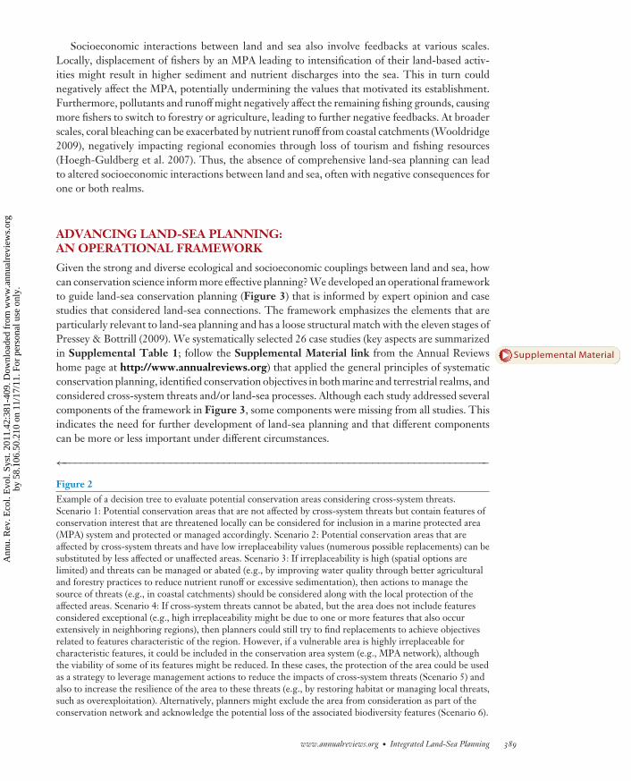
An assessment of both single-realm and cross-system threats is needed to determine suitablelocations for conservation areas (Stoms et al. 2005, Wilson et al. 2005). In general, includinghighly vulnerable areas in conservation networks will compromise conservation objectives if theprobability of persistence of their valued features is low (Beck 2003, Game et al. 2008, Wilson et al.2005), especially if conservation of alternative areas can achieve the same objectives. For this reason,planners often aim to avoid imminent threats where possible. Potential replacements for morethreatened areas can be identified in several ways, including analysis of irreplaceability (Margules& Pressey 2000), which can provide maps of options for achieving objectives and give scope forparticipation and negotiation. Depending on circumstances, strategies other than avoidance ofcurrent or potential threat might be appropriate, especially if highly irreplaceable marine areasfall within the zone of influence of cross-system threats. Figure 2 illustrates a decision tree thatcan be used to evaluate potential conservation areas exposed to cross-system threats. Strategies tomanage cross-system threats will depend on irreplaceability, the intensity of threats, and the likelyeffectiveness and costs of abating them (Klein et al. 2010).
Socioeconomic Interactions
People are an important link between the land and sea, and hence solutions to land-sea planningshould consider socioeconomic interactions between realms. Most of the world’s population livesin the coastal zone and therefore strongly influences land-sea processes (Cicin-Sain & Belfiore2005) and drives cross-system threats (Figure 1). Curtailing these threats therefore involves man-aging people’s use of the environment across the land-sea continuum, thereby affecting peoplepositively and negatively on land (Carwardine et al. 2008) and in the sea (Klein et al. 2008a).Nonetheless, planning for the socioeconomic benefits and impacts of conservation actions hasbeen undertaken only within single realms.
Conservation actions in one realm can have socioeconomic implications in another(Cruz-Trinidad et al. 2009), particularly in regions where land-sea processes and/or cross-systemthreats are strongly linked to local livelihoods. Consider the case of a forested catchment thatdrains into a near-shore coral reef ecosystem. If the coastal forest is converted to an intensive land
←−−−−−−−−−−−−−−−−−−−−−−−−−−−−−−−−−−−−−−−−−−−−−−−−−−−−−−−−−−−−−−−−−−−−−−−−−−−−−−−−−−−−−−−−−−Figure 1Cross-system threats: sources, affected realms, direction, stressors and areas to target for action. Notes: aThreat classes are based onSalafsky et al. (2008). bOn the basis of existing studies (Abell et al. 2007; Halpern et al. 2007, 2008, 2009), we anticipate that cross-system threats will have an array of impacts across the land-sea continuum, but a comprehensive review of these is not yet available. Wesuggest an initial broad scale of potential exposure to stressors and intensity of impacts associated with cross-system threats (see Wilsonet al. 2005). cA classification commonly used identifies point and nonpoint sources of pollution, which can be used to classify sources ofcross-system threats. Point sources can be addressed directly by managing individual facilities or structures, whereas nonpoint sourcesrequire actions associated with areas or regions. dThreat agents or stressors are defined as environmental and biotic factors that exceedtheir natural ranges of variation owing to human activities (Mullan-Crain et al. 2008).
www.annualreviews.org • Integrated Land-Sea Planning 387
Ann
u. R
ev. E
col.
Evo
l. Sy
st. 2
011.
42:3
81-4
09. D
ownl
oade
d fr
om w
ww
.ann
ualr
evie
ws.
org
by 5
8.10
6.50
.210
on
11/1
7/11
. For
per
sona
l use
onl
y.

ES42CH18-Gaines ARI 7 October 2011 15:59
use, such as oil palm production, increased pollutants could negatively affect the reef (Beger &Possingham 2008, Huber 1994) and potentially also damage marine tourism and fisheries. In theChesapeake Bay, for example, eutrophication derived from agriculture has contributed to declinesin demersal fish, resulting in a shift to fishery landings dominated by pelagic species (Kemp et al.2005). Alternatively, if the coastal forest is protected and contains charismatic wildlife, touristsvisiting the marine area might also visit the forest, thus providing additional income to the lo-cal economy. In addition to coordination, managing across realms requires social and economicforesight. For example, establishment of an MPA might force fishers to supplement their incomeby extending land-based activities such as forestry and agriculture, thereby negatively affectingterrestrial biodiversity.
Protect and/ormanage area
Threatscan be
managed?
Yes
No
Low
High
Look for areplacement
Potentialconservation area
Areairreplaceability
Manage cross-systemthreat source
And
Evaluate portfolio ofconservation alternatives
Yes
No
Containsexceptional
features?
Exclude area and acknowledge loss
Leverage actions to minimize threatAnd Makechoice
Cross-systemthreats?
Scenario 2
Scenario 3
Scenario 4
Scenario 5
Scenario 6
Scenario 1
No
Yes
388 Alvarez-Romero et al.
Ann
u. R
ev. E
col.
Evo
l. Sy
st. 2
011.
42:3
81-4
09. D
ownl
oade
d fr
om w
ww
.ann
ualr
evie
ws.
org
by 5
8.10
6.50
.210
on
11/1
7/11
. For
per
sona
l use
onl
y.
ES42CH18-Gaines ARI 7 October 2011 15:59
Socioeconomic interactions between land and sea also involve feedbacks at various scales.Locally, displacement of fishers by an MPA leading to intensification of their land-based activ-ities might result in higher sediment and nutrient discharges into the sea. This in turn couldnegatively affect the MPA, potentially undermining the values that motivated its establishment.Furthermore, pollutants and runoff might negatively affect the remaining fishing grounds, causingmore fishers to switch to forestry or agriculture, leading to further negative feedbacks. At broaderscales, coral bleaching can be exacerbated by nutrient runoff from coastal catchments (Wooldridge2009), negatively impacting regional economies through loss of tourism and fishing resources(Hoegh-Guldberg et al. 2007). Thus, the absence of comprehensive land-sea planning can leadto altered socioeconomic interactions between land and sea, often with negative consequences forone or both realms.
ADVANCING LAND-SEA PLANNING:AN OPERATIONAL FRAMEWORK
Given the strong and diverse ecological and socioeconomic couplings between land and sea, howcan conservation science inform more effective planning? We developed an operational frameworkto guide land-sea conservation planning (Figure 3) that is informed by expert opinion and casestudies that considered land-sea connections. The framework emphasizes the elements that areparticularly relevant to land-sea planning and has a loose structural match with the eleven stages ofPressey & Bottrill (2009). We systematically selected 26 case studies (key aspects are summarizedin Supplemental Table 1; follow the Supplemental Material link from the Annual Reviewshome page at http://www.annualreviews.org) that applied the general principles of systematicconservation planning, identified conservation objectives in both marine and terrestrial realms, andconsidered cross-system threats and/or land-sea processes. Although each study addressed severalcomponents of the framework in Figure 3, some components were missing from all studies. Thisindicates the need for further development of land-sea planning and that different componentscan be more or less important under different circumstances.
←−−−−−−−−−−−−−−−−−−−−−−−−−−−−−−−−−−−−−−−−−−−−−−−−−−−−−−−−−−−−−−−−−−−−−−−−Figure 2Example of a decision tree to evaluate potential conservation areas considering cross-system threats.Scenario 1: Potential conservation areas that are not affected by cross-system threats but contain features ofconservation interest that are threatened locally can be considered for inclusion in a marine protected area(MPA) system and protected or managed accordingly. Scenario 2: Potential conservation areas that areaffected by cross-system threats and have low irreplaceability values (numerous possible replacements) can besubstituted by less affected or unaffected areas. Scenario 3: If irreplaceability is high (spatial options arelimited) and threats can be managed or abated (e.g., by improving water quality through better agriculturaland forestry practices to reduce nutrient runoff or excessive sedimentation), then actions to manage thesource of threats (e.g., in coastal catchments) should be considered along with the local protection of theaffected areas. Scenario 4: If cross-system threats cannot be abated, but the area does not include featuresconsidered exceptional (e.g., high irreplaceability might be due to one or more features that also occurextensively in neighboring regions), then planners could still try to find replacements to achieve objectivesrelated to features characteristic of the region. However, if a vulnerable area is highly irreplaceable forcharacteristic features, it could be included in the conservation area system (e.g., MPA network), althoughthe viability of some of its features might be reduced. In these cases, the protection of the area could be usedas a strategy to leverage management actions to reduce the impacts of cross-system threats (Scenario 5) andalso to increase the resilience of the area to these threats (e.g., by restoring habitat or managing local threats,such as overexploitation). Alternatively, planners might exclude the area from consideration as part of theconservation network and acknowledge the potential loss of the associated biodiversity features (Scenario 6).
www.annualreviews.org • Integrated Land-Sea Planning 389
Supplemental Material
Ann
u. R
ev. E
col.
Evo
l. Sy
st. 2
011.
42:3
81-4
09. D
ownl
oade
d fr
om w
ww
.ann
ualr
evie
ws.
org
by 5
8.10
6.50
.210
on
11/1
7/11
. For
per
sona
l use
onl
y.

ES42CH18-Gaines ARI 7 October 2011 15:59
1. Regionalscoping
Identifyand involve
stakeholders
Evaluateconservation
context
Defineplanningdomain
Changing socioeconomic and political context
3. Synthesis
Monitorachievementof objectives
Mainstreamtechnical output
Applyconservation
actions
Schedule areasand actions
2. Integration and analysis
Socioecological research and monitoring
Decisionsupport
tools
Cross-systemthreats
Explicitcosts
Ecosystemservices
Planningunits
Conservationalternatives
Goals andconservation
objectives
Biodiversityacross realms
Climatechange
Spatially explicitactions and costs
Opportunitiesand constraints
New preferences,socioeconomic
status, and policies
New data onsocioecological
system status
Figure 3Operational framework for integrated land-sea planning. The framework is composed of three broad phases: regional scoping,integration and analysis, and synthesis. External arrows represent flows of information and feedbacks in the adaptive planning process,and they highlight the need to understand land-sea planning as a continuous and updatable process. Arrows encircling the second phaseindicate that planning involves iterative cycles of analysis in which conservation objectives, design criteria, and spatial data and modelsare adjusted to explore potential solutions under different environmental and socioeconomic scenarios.
The framework has three broad phases: regional scoping, integration and analysis, and synthe-sis. It includes familiar components of conservation planning adapted to a land-sea approach andsome less generic aspects particularly important for land-sea planning. Explicit in the frameworkis an adaptive approach (see Walters & Hilborn 1978) that is indicated by feedbacks that linkthe phases and reflect the iterative nature of planning. Feedbacks requiring reconsideration ofearlier parts of the process might follow, for example, anthropogenic changes to land/seascapes,altered social and economic conditions, new data sets, and monitoring of the effectiveness ofconservation actions (Sarkar et al. 2006). An adaptive approach is particularly relevant for land-sea planning owing to the uncertainty and complexity associated with planning across realms.Among the sources of uncertainty are our limited knowledge of land-sea interactions, lag timesbetween implementation of actions and measurable results, and difficulties in predicting climatechange, land-use change, and their potential impacts on water quality and marine ecosystems(Broderick 2008). The phases of the framework and their components are described in thefollowing sections.
390 Alvarez-Romero et al.
Ann
u. R
ev. E
col.
Evo
l. Sy
st. 2
011.
42:3
81-4
09. D
ownl
oade
d fr
om w
ww
.ann
ualr
evie
ws.
org
by 5
8.10
6.50
.210
on
11/1
7/11
. For
per
sona
l use
onl
y.
ES42CH18-Gaines ARI 7 October 2011 15:59
Planning domain:region across whichconservation areas areassessed and comparedfor investment inactions to achieveconservation objectives
Conservationcontext: backgroundabout governance,ownership, uses,existing management,and threats in theplanning region,including interactionsbetween terrestrial andmarine socioecologicalsystems
Goals: a collectivevision of aspirations,such as representationand persistence ofbiodiversity, improvedlivelihoods, and/ormaintenance ofecosystem services
Regional Scoping
Land-sea planning involves several additional considerations about aspects of scale and regionalscoping. Scoping components lay the foundation for a better understanding of the broad oppor-tunities and constraints that will influence the implementation of conservation actions and set thescene for the following planning phases. Although these issues are critical to conservation planningsuccess, they are less tied to the ecological issues at the core of this review and are not examinedin detail here.
Defining the planning domain. An integrated land-sea approach requires identification of thesources and zones of influence of cross-system threats and spatial representations of land-seaprocesses (from upland areas to the nearshore and sometimes offshore marine environment), bothchallenging tasks.
Defining the limits of the planning domain in the terrestrial realm is not always straightforwardbecause land that influences marine areas can extend well inland. For example, waters that dischargeinto the Gulf of Mexico originate from an area of almost 3 million km2, or approximately 40% ofthe United States (Mitsch et al. 2001). A single planning process at this scale is extremely difficultbecause of the diversity of jurisdictions and stakeholders that would need to be involved as well asthe time, expense, and requirements to collect consistent data. Full-catchment approaches havecovered small catchments (e.g., the 425-km2 catchment of Jervis Bay, Australia; Dutton et al. 1994)or larger and multiple catchments, albeit at coarse resolution (e.g., all coastal catchments draininginto the Mesoamerican Caribbean Reef; Kramer & Kramer 2002). Other planning exercises havefocused on the downstream ends of major rivers draining into the ocean (e.g., Chesapeake BayLowlands Ecoregional Plan; TNC 2002) or portions of catchments with major direct impacts onmarine ecosystems that are likely to be developed in the near future (e.g., Mission Aransas Estuary,Texas; Dunton 2009).
Stakeholders and conservation context. Identifying and involving stakeholders (Pomeroy &Douvere 2008) and evaluating the conservation context (Pressey & Bottrill 2009) involve criticalsocial and political analyses that bring diverse views and goals into discussion and place the subse-quent spatial analyses in the context of multiple social, economic, and political factors operatingacross terrestrial and marine realms (Cicin-Sain & Belfiore 2005).
Integration and Analysis
The second phase integrates biological and socioeconomic information, which involves adapt-ing several familiar components of conservation planning to a land-sea approach (e.g., planninggoals and objectives as well as socioeconomic data and models). Other less typical aspects includeincorporating land-sea interactions and adapting decision support systems to address multipleobjectives that include land-sea interactions.
Goals and conservation objectives. Goals, framed qualitatively, provide the link between valuesand the quantitative analyses that characterize systematic conservation planning (Pressey & Bottrill2009). In addition to goals associated with individual realms (e.g., protection of terrestrial andmarine species and habitats), goals for land-sea planning include maintenance and restoration ofland/seascape connectivity—defined by natural flows of organisms, water, materials, and energy—to ensure the persistence of biodiversity across realms (Bennett et al. 2006, Talley et al. 2006). Broadgoals to maintain marine ecological processes (e.g., Banks et al. 1999, Kramer & Kramer 2002)
www.annualreviews.org • Integrated Land-Sea Planning 391
Ann
u. R
ev. E
col.
Evo
l. Sy
st. 2
011.
42:3
81-4
09. D
ownl
oade
d fr
om w
ww
.ann
ualr
evie
ws.
org
by 5
8.10
6.50
.210
on
11/1
7/11
. For
per
sona
l use
onl
y.

ES42CH18-Gaines ARI 7 October 2011 15:59
Planning units:natural, administrative,or arbitrarysubdivisions ofplanning domainsutilized for assessmentand as building blocksfor systems ofconservation areas
ideally should be expanded into more explicit statements about specific land-sea linkages, such asmaintaining nutrient flows between marine and terrestrial ecosystems (e.g., Lombard et al. 2007).Goals referring to mitigation of cross-system threats also should be specific. Some examples are theidentification of areas or catchments to be protected or restored to minimize downstream impactson marine ecosystems and fisheries in Fiji (Atherton et al. 2005) and the Coral Triangle (Kleinet al. 2010). Goals related to integrated land-sea conservation have been rare, or stated but nottranslated into strategies to achieve them. Reasons include limited resources, lack of informationon land-sea interactions, differences in stakeholders’ interests, and stakeholders’ lack of awarenessof the importance of these linkages.
Once stakeholders agree upon goals, they need to be translated into (preferably) quantitativeconservation objectives (Pressey & Bottrill 2009). Land-sea planning objectives should includethose associated with spatial features that represent land-sea processes and areas to be managedor protected to mitigate cross-system threats. Planning exercises have identified diverse featuresassociated with maintaining land-sea processes. For example, Ardron et al. (2002), in designinga network of MPAs for the Central Coast of British Columbia, mapped and targeted streamsthat support migrations of anadromous species. Other studies have targeted keystone speciesthat deliver marine-derived nutrients to terrestrial ecosystems (e.g., seabirds and pinnipeds of thePrince Edward Islands, South Africa; Lombard et al. 2007) and freshwater ecosystems (e.g., salmonand steelhead in the Alaska Peninsula and Bristol Bay Basin; TNC 2004). Others have focused onspecies with life cycles reliant on both terrestrial and marine habitats, such as the land crab, whichmigrates to coastal waters to spawn (MPO 2003), and the whooping crane, which moves betweengrasslands and salt marsh (Dunton 2009). Conservation objectives related to land-sea interfacesor linking ecosystems (e.g., estuaries, mangroves, coastal streams) or their associated species (e.g.,crocodiles, estuarine turtles and fish, waterbirds) can also contribute to land-sea integration (e.g.,Florida’s Marine/Estuarine Site Assessment; Geselbracht et al. 2005).
Cross-system threats can be minimized by targeting potential sources of detrimental flows(e.g., areas with a high erosion potential; Atherton et al. 2005), preferably in combination withsetting quantitative water quality objectives (e.g., reduction of annual pollutant discharges fromcatchments in kilograms of nitrogen per hectare per year). Water quality objectives can be based onhistoric and current discharges as estimated by catchment modeling and monitoring, and ideallyon assessment of exposure thresholds or tolerance of marine species or habitats to pollutants aswell (Brodie et al. 2009, Queensland 2009).
Biodiversity across realms. Land-sea planning requires spatially explicit data on biodiversity pat-terns and ecological processes across the land-sea continuum. These include distribution modelsor occurrences of marine, terrestrial, and freshwater species, communities, and habitat types as wellas maps of features associated with land-sea processes. Data and models are commonly focused on asingle realm or separate realms, although these might include some species occurring in more thanone realm (e.g., diadromous and migratory species of economic and ecological importance; TNC2003, Vander Schaaf et al. 2006). The types and resolutions of spatial data on biodiversity varyacross realms but are generally more diverse and detailed in terrestrial environments (Avery 2003).
Collection of data on and mapping of land-sea processes requires identification of the featuresthat will serve as surrogates to be represented in conservation areas (Cowling et al. 1999). Build-ing on studies that explicitly integrate processes into planning (e.g., Cowling & Pressey 2003,Cowling et al. 1999, Rouget et al. 2003) and methods to incorporate processes across realms pro-posed by Beger et al. (2010), we identified four potential strategies to plan for land-sea processes:design criteria, variable objectives, planning units, and movable conservation areas (Table 2).Few studies have addressed the design needs of land-sea processes in a spatially explicit way.
392 Alvarez-Romero et al.
Ann
u. R
ev. E
col.
Evo
l. Sy
st. 2
011.
42:3
81-4
09. D
ownl
oade
d fr
om w
ww
.ann
ualr
evie
ws.
org
by 5
8.10
6.50
.210
on
11/1
7/11
. For
per
sona
l use
onl
y.

ES42CH18-Gaines ARI 7 October 2011 15:59
Table 2 Strategies to incorporate land-sea processes into conservation planning
Design criteria Spacing: Define a minimum and/or maximum distance between potential conservation areas that containcomplementary terrestrial/freshwater and marine habitats to ensure biological or physical connectivitybetween realms or to reduce the risk of disturbances affecting multiple conservation areas simultaneously.
Buffers: Define buffers for conservation areas along terrestrial-marine interfaces or around other areas thatsupport land-sea processes. The roles of buffers are to ensure that areas supporting the processes ofinterest are managed appropriately and that, as far as possible, threatening processes are excluded.
Replication: Represent terrestrial or marine features associated with land-sea processes in multipleconservation areas to minimize simultaneous exposure to natural or anthropogenic disturbances.
Adjacency: Place terrestrial/freshwater and marine conservation areas beside each other to maintainconnectivity and promote the persistence of land-sea processes.
Alignment: Include the major movement axes of organisms (e.g., between the foraging and nesting areas ofseabirds) or the locations of physical features (e.g., ocean fronts) associated with land-sea processes.
Connectivity: Select areas for conservation management that promote one or more relevant aspects ofconnectivity. These could include continuous corridors of suitable aquatic or terrestrial areas, minimumspacing between areas to facilitate movement of organisms, or simultaneous selection of areas that arefunctionally, even if not spatially, connected (e.g., to allow for organisms inhabiting different realms tomove between them to complete their life cycles or to recolonize areas through the movement/transportof planktonic larvae, considering currents and larval biological characteristics and behavior).
Variable objectives Habitats: Set objectives for both terrestrial/freshwater and marine habitats that are linked throughmovements of organisms (e.g., wetlands, estuaries, coral reefs) and that need to be protectedsimultaneously, perhaps with maximum allowable separation distances, to sustain these interactions.
Species: For organisms that periodically move between realms or that have life stages associated withdifferent realms, set separate objectives for terrestrial/freshwater and marine occurrences to protect theircomplete life cycles.
Stratification: To fully represent the internal heterogeneity of narrow land-sea interfaces, a general (larger)objective can be assigned to the interface type of interest as a whole (e.g., 20% of rocky intertidal shores)and specific (progressively smaller) objectives to lower classes or subcategories identified at a finerscale/resolution (e.g., 10% and 5% of exposed and lower exposed rocky intertidal shores, respectively).
Planning units Special: Delineate planning units (e.g., linear, irregular) that are configured specifically to representinterfaces associated with land-sea processes of interest.
Smaller: Use smaller planning units in interface habitats to recognize the greater spatial heterogeneityfound in and around these areas as well as to increase selection precision and minimize overrepresentation.
Movable areas Spatial: Apply conservation actions to different areas at different times according to the occurrences ofdynamic physical features and associated species’ habitats.
Temporal: Apply conservation actions in the same areas at different times or seasons to protect vulnerablelife stages of species moving across realms (e.g., during migration, reproduction, or spawning) or flows(e.g., peak river discharges) that sustain land-sea processes.
Lagabrielle et al. (2009) illustrated for Reunion Island the need to create an inland buffer alongthe coastline to protect some land-sea processes, including settlement of new species and move-ments of organisms between land and sea. As part of the design of the Prince Edward Islands’MPA, Lombard et al. (2007) included portions of oceanic foraging areas based on the majormovement axes of seabirds and pinnipeds to maintain the input of marine-derived nutrients intoterrestrial systems. In British Columbia, Ardron et al. (2002) incorporated the flow of nutrientsbetween oceans, streams, and riparian areas by setting objectives for key salmon-spawning streams,estuaries, and holding sites. Protection of extensive processes, such as the bidirectional nutrientflows mediated by the migration of salmon, could also require the protection of terrestrial features
www.annualreviews.org • Integrated Land-Sea Planning 393
Ann
u. R
ev. E
col.
Evo
l. Sy
st. 2
011.
42:3
81-4
09. D
ownl
oade
d fr
om w
ww
.ann
ualr
evie
ws.
org
by 5
8.10
6.50
.210
on
11/1
7/11
. For
per
sona
l use
onl
y.

ES42CH18-Gaines ARI 7 October 2011 15:59
Ecosystem services:resources andprocesses supplied bynatural ecosystems forthe benefit of humans,such as foodprovisioning, climateregulation, andrecreation
(e.g., riparian vegetation, upland forests) and management of freshwater networks that are cur-rently overlooked in marine planning, but this is yet to be demonstrated.
Cross-system threats. Understanding the dynamics and potential impacts of cross-systemthreats is necessary to develop spatial alternatives for conservation areas that can minimize vul-nerability and maximize conservation outcomes. Models of cross-system threats can provide plan-ners with four kinds of information: sources, zones of influence, potential impacts, and expectedchanges in intensity or patterns in response to land/seascape dynamics or to conservation actions.Although planning exercises have modeled and incorporated cross-system threats (e.g., Crist et al.2009, Green et al. 2009, Tallis et al. 2008), none has addressed them comprehensively throughthe four types of information above.
Identifying actions to effectively mitigate cross-system threats depends on mapping and model-ing of those threats, which can be demanding of time and data. Spatial precision might be infeasiblein some circumstances, so coarse-resolution models to identify general patterns at regional scalesmight be necessary. Models of threats are usually land-based and have generally neglected threatsoriginating in marine and freshwater systems (Figure 1). Potential zones of influence of pointsources are usually mapped as single or multiple-ringed buffers associated with different levelsof impact (Green et al. 2009), but they also can be modeled in more complex ways if directionaldata on intensity and effects on ecosystems are available. This might be guided by expert opinion(e.g., Halpern et al. 2009, Klein et al. 2008b). Mapping nonpoint sources involves estimating thepotential contribution of different areas to the extent or intensity of threats (e.g., pollutant dis-charge), usually through catchment models, followed by mapping the zone of marine influenceusing diffusion models (e.g., Dunton 2009, Halpern et al. 2009, TNC 2008), transport models(e.g., Cherubin et al. 2008), or river plume models (e.g., Tallis et al. 2008).
Ecosystem services. Ecosystem services describe what people value from ecosystems and havebecome prominent components of planning exercises (Chan et al. 2006, Egoh et al. 2007). Theimportance of land-sea processes in the provision of diverse ecosystem services (e.g., pollutionbuffering, sediment trapping) is well recognized (Granek et al. 2010, Silvestri & Kershaw 2010),but these generally have been overlooked in setting explicit conservation objectives. Some land-sea processes are critical to sustaining coastal and marine ecosystems and species of economicimportance or have been linked to other important processes, such as maintenance of oceanicand terrestrial productivity (Table 1). Maintenance of the services provided by coastal and ma-rine ecosystems (e.g., nutrient cycling) and the economic benefits associated with these (e.g., forfisheries and tourism) are commonly recognized as broad planning goals (Beck & Odaya 2001,Green et al. 2009, Hinchley et al. 2007), but seldom have been translated into spatial data andquantitative conservation objectives. A study conducted by The Nature Conservancy (TNC 2007)in Florida’s Northwest Coast exemplifies a method to incorporate ecosystem services providedby coastal wetlands, in this case hazard mitigation, into conservation planning. Most studies havenot considered ecosystem services or have limited their attention to provisioning services suchas sustaining fisheries. Some services supported by land-sea processes might be incorporated in-cidentally through objectives for other features, but others will remain unprotected, and theirpersistence will therefore remain at risk. Silvestri & Kershaw (2010) developed a framework tohelp planners understand, map, and value ecosystem services along the land-sea continuum andto determine the spatial alternatives for their protection or restoration.
Climate change. Of special concern for land-sea planning are the effects of climate change onland-sea processes and cross-system threats. Climate change–associated alterations in land-sea
394 Alvarez-Romero et al.
Ann
u. R
ev. E
col.
Evo
l. Sy
st. 2
011.
42:3
81-4
09. D
ownl
oade
d fr
om w
ww
.ann
ualr
evie
ws.
org
by 5
8.10
6.50
.210
on
11/1
7/11
. For
per
sona
l use
onl
y.
ES42CH18-Gaines ARI 7 October 2011 15:59
processes, such as migration of fish and nutrient runoff, are anticipated (Nohara et al. 2006, Reistet al. 2006). Projected increases in temperature and altered precipitation regimes will likely resultin more intense nutrient and sediment runoff associated with land use change, at least in someregions within the tropics (Nohara et al. 2006, Zhu et al. 2008). Synergistic effects of hypoxia,temperature, and CO2 levels on the physiology of marine organisms are also expected to intensifywith climate change (Harley et al. 2006). The projected sea level rise will probably affect land-seainterface ecosystems (e.g., mangroves; Gilman et al. 2008) as well as terrestrial communities byreducing habitat for species in coastal zones (LaFever et al. 2007). Accordingly, impacts of climatechange on biodiversity and threats, and the interactions between them, should be considered forboth land and sea.
Although climate change is mentioned as a major concern in most planning exercises, few haveexplicitly modeled climate-related changes, and most of these are restricted to species and habitatsassociated with a single realm or separate realms (e.g., shifts in climatic variables across terrestrialecosystem units to identify potential refuges; TNC 2005). More often, general strategies or designprinciples are followed with the aim of increasing the resilience of ecosystems to climate change byprotecting key habitats and ecosystems. For example, the MPA network designed for Kimbe Bay,Papua New Guinea, considered spreading risks through representation and replication, protectionof special sites (e.g., spawning aggregations, nesting areas, and sites more resistant to climatechange), connectivity (maximum separation of 15 km), and minimum MPA size (10 km2) (Greenet al. 2009). Similar efforts guided MPA network design along the California coast under theMarine Life Protection Act (Gleason et al. 2010)
Explicit costs. Integration of socioeconomic considerations in land-sea planning is challengingbut can be attempted by minimizing the costs of conservation actions to people (Naidoo et al.2006). A common approach in single-realm planning is to minimize costs of management actionswhile achieving conservation objectives (Carwardine et al. 2008). In land-sea planning, costs arecommonly integrated into cost-suitability indices developed for terrestrial and marine realmsindependently. Cost-suitability indices integrate economic, sociopolitical, and biological factorsto preferentially select areas with higher long-term viability and avoid areas with high conservationcosts (Geselbracht et al. 2009, TNC 2005). Ideally, land-sea planning should consider costs inboth realms simultaneously. For example, a study in the Coral Triangle region, where coral reefconservation was the main goal, considered the costs of conservation actions on the land (i.e., costsassociated with management of terrestrial protected areas and forgone economic return fromcropping and grazing to reduce land-based threats) and in the sea (i.e., MPA management costsand associated opportunity costs for fishermen) (Klein et al. 2010). Although the costs were not ex-pressed in economic terms, Tallis et al. (2008) considered costs for marine conservation associatedwith land-based threats. There might, however, be trade-offs between minimizing cross-systemthreats and minimizing negative socioeconomic impacts across the land-sea interface. For exam-ple, if much land needs to be protected to ensure the persistence of marine biodiversity potentiallyaffected by land-based pollution, but people rely on agriculture for subsistence, the cost of ter-restrial protected areas could be unfeasibly high. In these cases, other conservation actions, suchas better agricultural practices, may minimize downstream impacts at lower cost (Gordon 2007).
Planning units. The delineation of planning units in land-sea planning is influenced by the samefactors considered in terrestrial and marine exercises, including data resolution, size of planningregion, and socioeconomic and political factors linked to implementation (Cowling & Pressey2003, Pressey & Logan 1998). In land-sea planning, another consideration for the choice ofplanning units is the need to integrate conservation areas across the land-sea interface, which
www.annualreviews.org • Integrated Land-Sea Planning 395
Ann
u. R
ev. E
col.
Evo
l. Sy
st. 2
011.
42:3
81-4
09. D
ownl
oade
d fr
om w
ww
.ann
ualr
evie
ws.
org
by 5
8.10
6.50
.210
on
11/1
7/11
. For
per
sona
l use
onl
y.

ES42CH18-Gaines ARI 7 October 2011 15:59
Decision supporttools: computerprograms that provideanalytical andgraphical capabilitiesto facilitatenegotiation,exploration ofscenarios, andinvolvement ofstakeholders inconservation planning
often requires different units for the terrestrial (e.g., subcatchments, ownership parcels), marine(e.g., hexagons), and interface (e.g., linear) parts of the planning domain. Small polygonal units(e.g., Geselbracht et al. 2005) can also be useful to recognize the spatial heterogeneity foundin narrow interfaces, to increase selection precision, and to minimize overrepresentation (seeTable 2 and Beger et al. 2010). Banks et al. (2005) used linear units to configure a system ofrepresentative intertidal conservation areas on the Queensland (Australia) coast. A study in theU.S. Pacific Northwest used diverse units: Terrestrial and freshwater features were summarized insubcatchments; estuaries were each mapped as single planning units; and square units intersectedthe coastline, offshore islands, and upstream tidal reaches of major rivers (Vander Schaaf et al.2006). In contrast, a planning exercise in Alaska’s Cook Inlet used a uniform hexagonal grid thatcovered the land and sea portions of the planning domain (TNC 2003). Until now, most planningexercises have delineated planning units independently for the land and the sea, and their designand configuration have not accounted for linkages between the realms.
Decision support tools. Major challenges to land-sea planning come with the need to managedata from terrestrial, freshwater, and marine ecosystems, to consider connectivity between realms,and to relate potential conservation areas to sources and impacts of cross-system threats. Deci-sion support tools are therefore key elements in land-sea planning. Incorporation of connectivitybetween realms can require modification of data or adaptation of existing tools and algorithms(Beger et al. 2010, Mumby 2006, Stoms et al. 2005). Beger et al. (2010) examined existing and newmethods to incorporate ecological linkages between realms supported by conservation planningsoftware, but few of these approaches have actually been used. Approaches to integration in de-cision support systems include design criteria to force the selection of marine conservation areasclose to well-protected terrestrial or estuarine areas and away from potential cross-system threats(Fernandes et al. 2005, Green et al. 2009, Tallis et al. 2008). They also include simultaneousprioritization across realms (TNC 2003, 2005) and evaluation of current and projected land-usescenarios to explore alternatives for mitigation of threats (Dunton 2009). Land-sea planning willrequire the use and adaptation of existing conservation planning software interfaced with othermodeling and simulation tools to integrate the diversity of data and models required (e.g., Cristet al. 2009, TNC 2007).
Conservation planners often use numerical optimization tools (e.g., C-Plan, Marxan, Zonation)to help identify priorities for conservation. Two studies demonstrate methods for integrated land-sea planning using Marxan (Ball et al. 2009). Tallis et al. (2008) explored changes in the distributionof threats and the configuration of marine priority areas when cross-system threats were explic-itly considered. They incorporated the impact of river-derived threats to identify conservationpriorities in the U.S. Pacific Northwest (Figure 4). Hazlitt et al. (2010) incorporated a land-seaprocess to identify priorities for conservation of the marbled murrelet in British Columbia, Canada.For this species, they found that the inclusion of marine objectives (a function of quality of anddistance to potential suitable marine foraging habitats) in the planning process influenced the lo-cation of priority areas for terrestrial reserves (Figure 5), especially when conservation resourcesonly allowed for the protection of a small fraction of available terrestrial habitat.
Conservation alternatives. Systematic conservation planning involves the development andcomparison of alternative configurations of areas and alternative actions applied to those areas.Even when designs are presented for public viewing and comment, usually much flexibility existsto reconfigure them and reallocate actions (Cowling et al. 2003).
Approaches to exploring conservation alternatives are diverse, including decision support sys-tems with input from experts and managers (Geselbracht et al. 2009, TNC 2005), successive
396 Alvarez-Romero et al.
Ann
u. R
ev. E
col.
Evo
l. Sy
st. 2
011.
42:3
81-4
09. D
ownl
oade
d fr
om w
ww
.ann
ualr
evie
ws.
org
by 5
8.10
6.50
.210
on
11/1
7/11
. For
per
sona
l use
onl
y.

ES42CH18-Gaines ARI 7 October 2011 15:59
0 50 100 150 200 km
a
Cross-systemthreats
Best solution
Pacific Ocean
Single-systemthreats
Best solution
N
0 50 100 150 200 km
b
Pacific Ocean
N
Figure 4Differences in the spatial location of marine conservation priorities between scenarios that incorporated and ignored cross-systemthreats. (a) Only single-system threats considered. (b) Planning units within the plume of the Columbia River (enclosed by the whiteline) had higher costs for marine conservation. Most coastal marine areas within the zone of influence of the river plume were notselected. Copyright c© 2008 Wiley. Figure reproduced and modified from Tallis et al. (2008) with permission from the authors.
designs open for comment and revision (Fernandes et al. 2005), interactive and participatory pro-cesses guided by decision support systems (Dunton 2009, Pressey et al. 2009), and expert-drivenprocesses supported by geographic information systems (Banks et al. 1999, Enriquez-Andradeet al. 2005). These approaches can consider land-sea linkages (e.g., Banks et al. 1999, Kramer &Kramer 2002, TNC 2004). Regardless of the approach, developing conservation alternatives usu-ally involves iterative cycles of analysis in which conservation objectives, design criteria, and spatialdata and models are modified or adjusted to suit stakeholders’ preferences and to explore potentialsolutions under different environmental, socioeconomic, and protection scenarios (Osmond et al.2010, Pressey et al. 2009).
Conservation scenarios can reflect variations in objectives (e.g., higher/lower representation),different models of threats (e.g., current/projected, cross-system/single-realm, rapid/moderatechange), types of protection and management (e.g., zoning alternatives), and costs, among otherfactors. Different types and levels of protection and use (e.g., reservation, water management,restoration, land management, fishery regulation) can be linked to specific conservation areasacross realms (Banks et al. 1999, Dunton 2009, MPO 2003, TNC 2003). Addressing specificthreats, such as high sediment fluxes into coral reefs, might require specific erosion mitigationpractices, including reforestation and regulation of logging in catchments (Atherton et al. 2005).Ideally, these strategies should be translated into integrated terrestrial, freshwater, and marine
www.annualreviews.org • Integrated Land-Sea Planning 397
Ann
u. R
ev. E
col.
Evo
l. Sy
st. 2
011.
42:3
81-4
09. D
ownl
oade
d fr
om w
ww
.ann
ualr
evie
ws.
org
by 5
8.10
6.50
.210
on
11/1
7/11
. For
per
sona
l use
onl
y.

ES42CH18-Gaines ARI 7 October 2011 15:59
Higher withmarine values
Comparablefrequencies
Higher withoutmarine values
N
Figure 5Difference in priority areas for conservation of marbled murrelet terrestrial nesting habitat when marineobjectives for this species were incorporated or omitted. This species requires old-growth forest for nestingand high-quality marine habitats for foraging.
multiple-use conservation systems in which different activities are permitted, prohibited, or reg-ulated consistent with ecological and socioeconomic requirements and constraints (Dutton et al.1994, Fernandes et al. 2005, Vander Schaaf et al. 2006).
Synthesis
The transition from design to implementation involves aspects of particular relevance to land-sea planning, including deciding on the conservation areas that will be protected/managed first,which involves trade-offs between land and sea; adapting and communicating planning outputsto stakeholders associated with different realms and across land-sea jurisdictions; and monitoringthe achievement of objectives as conservation actions are implemented.
Schedule areas and actions. Conservation plans are seldom fully implemented over short peri-ods, so scheduling of incremental conservation actions is usually necessary to minimize the extent
398 Alvarez-Romero et al.
Ann
u. R
ev. E
col.
Evo
l. Sy
st. 2
011.
42:3
81-4
09. D
ownl
oade
d fr
om w
ww
.ann
ualr
evie
ws.
org
by 5
8.10
6.50
.210
on
11/1
7/11
. For
per
sona
l use
onl
y.

ES42CH18-Gaines ARI 7 October 2011 15:59
Mainstreaming:translation of technicalplanning products intoforms readilyaccessible to diversestakeholders tofacilitate theimplementation ofconservation actions
to which objectives are compromised by ongoing attrition of biodiversity (Pressey et al. 2007).Hence, one of the particular challenges of land-sea planning is the requirement for simultaneousscheduling in terrestrial and marine regions so that threats within and between realms can be ad-dressed comprehensively. Klein et al. (2010) described a protocol to guide planners in schedulingconservation actions simultaneously across realms in the Coral Triangle. The study demonstratedthat in any one period, integrated scheduling might require choices between marine areas, be-tween terrestrial areas, or between areas on either side of the shoreline. Deciding between twocritical catchments that are equally vulnerable and linked to priority marine areas might requirealso assessing local values (e.g., terrestrial endangered and rare species and communities). In thesecases, experts can play a critical role in determining which areas require immediate attention (e.g.,Banks et al. 1999, MPO 2003, TNC 2002), especially when data on the dynamics of local andcross-system threats are limited.
Mainstream technical outputs. Mainstreaming is a critical, but often overlooked, element inconservation planning (Pierce et al. 2005). In land-sea planning, planners should engage withstakeholders and decision makers with influence on or jurisdiction in the land-sea continuum(e.g., Day et al. 2003, Dunton 2009, MPO 2003), in particular those responsible for land-seaissues, such as catchment-based organizations that consider marine water quality. Mainstreamingfor multiple and diverse stakeholders, such as municipal planners, coastal management authorities,and the agricultural and fishing industries, can be complex and requires substantial technical andfinancial capacity.
Apply conservation actions. Application of actions involves the critical transition from designof conservation areas to implementation of feasible and effective actions on the ground and in thewater. Application of actions in land-sea planning will likely require several strategies to addressthe threats in the land-sea continuum that are implemented via negotiations and arrangementswith diverse stakeholders (Baker et al. 2011, Green et al. 2009). Application also requires coordina-tion of administrative arrangements between governmental institutions at different levels (Duttonet al. 1994). Ideally, planning should also deliver a strategy that integrates conservation actionsbetween realms and promotes collaboration of stakeholders from different realms. Existing bodiesoperating beyond the land-sea boundaries, such as regional catchment management organiza-tions, can significantly contribute to coordination of actions across realms. Inevitably, new dataand unexpected constraints and opportunities will be encountered as designs are interpreted andapplied. This will likely require extensive adaptation of designs to accommodate these changes(Figure 3).
Monitor achievement of objectives. Monitoring is a critical component of an adaptive planningprocess (Baker et al. 2011). It informs planners about the effectiveness of applied actions in achiev-ing objectives across realms, so that actions, and the areas where they are to be applied, can beadjusted accordingly (Dunton 2009, Dutton et al. 1994, Fernandes et al. 2005). Even though theyare a critical component of effective planning, monitoring activities either have not been consid-ered or have been developed for a single realm or separate realms. Rarely has monitoring includedspecies and habitats in different realms as well as sources and impacts of cross-system threats. No-table exceptions are the system-wide monitoring program linked to the Mission-Aransas land-seaplanning initiative (http://cdmo.baruch.sc.edu; Dunton 2009) and the water quality strategy forthe Great Barrier Reef Marine Park (Queensland 2009).
www.annualreviews.org • Integrated Land-Sea Planning 399
Ann
u. R
ev. E
col.
Evo
l. Sy
st. 2
011.
42:3
81-4
09. D
ownl
oade
d fr
om w
ww
.ann
ualr
evie
ws.
org
by 5
8.10
6.50
.210
on
11/1
7/11
. For
per
sona
l use
onl
y.

ES42CH18-Gaines ARI 7 October 2011 15:59
CHALLENGES FOR THE FUTURE
Scientists, managers, and conservation practitioners have called for an integrated approach tomanaging terrestrial, freshwater, and marine socioecological systems (Dutton et al. 1994, Gordon2007, Olsson et al. 2008, Stoms et al. 2005). Different approaches to land-sea integration havebeen followed (for a description of integration levels, see Tallis et al. 2008), including concurrentarea prioritization exercises for terrestrial and marine systems that are later assembled to build asingle plan (e.g., Floberg et al. 2004); simultaneous planning, in which land and marine featuresare targeted at the same time and some measure of conservation cost is minimized for bothrealms simultaneously (e.g., TNC 2005); and explicit incorporation of cross-system threats (e.g.,Tallis et al. 2008) and/or land-sea processes (e.g., Lombard et al. 2007) in the prioritizationprocess. Within these approaches, different elements of the framework described above have beenincorporated, but no planning exercise has addressed all.
Expert opinion (based on a survey we conducted) indicates that few components of the op-erational framework we outlined have been incorporated into land-sea planning (Figure 6). Inaddition to the particular needs for improvement illustrated in Figure 6 and previously discussed,we summarize below three key challenges to land-sea planning based on reviewed studies, expertopinion, and our own experience.
Partial Integration of Cross-System Threats
Although cross-system threats are widely cited as a major concern for marine conservation andoften considered in land-sea planning exercises, these have been only partially incorporated intoprioritization processes. The impacts of threats with marine origins on upstream ecosystemsare poorly studied and not yet incorporated into planning (Green et al. 2009). Data requiredto model threats originating on land (e.g., pollutant loads and zones of offshore influence) areusually incomplete, available only for short periods, coarse in resolution (Atherton et al. 2005,Kramer & Kramer 2002), or inadequate for planning purposes (TNC 2002). Data limitationscan be overcome through the use of simplified models to assess exposure to cross-system threats(Ban et al. 2010, Maughan & Brodie 2009) or expert-based delineation of high-risk areas (Bankset al. 1999). However, simplified data limit the development of adequate conservation actionsto mitigate these threats, and they could result in erroneous conclusions and poor managementrecommendations. More advanced methods of catchment and ocean circulation modeling (e.g.,Brodie et al. 2009, Paris & Cherubin 2008) can be employed for land-sea planning if resources,data, and expertise are available. In most cases, however, lack of spatial data to calibrate and validatethe models remains a major challenge. Developing and integrating models into a decision supportsystem can be time- and labor-intensive, and trade-offs between quality of results and investmentin data and modeling seldom have been assessed (Crist et al. 2009, Dunton 2009).
Competing Objectives
Integrated land-sea planning must address many potentially conflicting objectives. Some studieshave found coincidence in the spatial distribution of priorities arising from different objectives,but others have not. Differences in the spatial distribution of conservation priorities for terrestrialbiodiversity and ecosystem services (Chan et al. 2006) and of freshwater and terrestrial priorities(Amis et al. 2009) suggest that values within coastal catchments derived from terrestrial conserva-tion objectives (e.g., connectivity between vegetation fragments) will not necessarily be spatiallycorrelated with those for marine conservation (e.g., reducing pollutant loads at river mouths).
400 Alvarez-Romero et al.
Ann
u. R
ev. E
col.
Evo
l. Sy
st. 2
011.
42:3
81-4
09. D
ownl
oade
d fr
om w
ww
.ann
ualr
evie
ws.
org
by 5
8.10
6.50
.210
on
11/1
7/11
. For
per
sona
l use
onl
y.

ES42CH18-Gaines ARI 7 October 2011 15:59
1
2
3
0
10
20
30
40
50
60
70
80
90
100
Pla
nn
ing
do
ma
in
Sta
keh
old
ers
Co
nse
rva
tio
nco
nte
xt
Go
als
Ob
ject
ive
s
Bio
div
ers
ity
da
ta
Cro
ss-s
yste
mth
rea
ts
Eco
syst
em
serv
ice
s
Clim
ate
ch
an
ge
Exp
licit
co
sts
Pla
nn
ing
un
its
De
cisi
on
sup
po
rt t
oo
ls
Co
nse
rva
tio
na
lte
rna
tiv
es
Sch
ed
ulin
g
Ma
inst
rea
min
g
Ap
ply
co
nse
rva
tio
na
ctio
ns
Mo
nit
ori
ng
Land-sea integration: average value
Perc
enta
ge o
f res
pond
ents
Phase 1 Phase 2 Phase 3
Low Medium High Average
Figure 6Expert opinion on the level of land-sea integration for each of the components of the operational framework in Figure 3. Integrationwithin components of the first planning phase was generally rated between low and medium. In the second planning phase, twocomponents were considered to have achieved relatively good integration: planning for cross-system threats (a common purpose ofland-sea planning) and the use of decision support tools. Also within the second phase, incorporation of climate change and explicitcosts seem to deserve special attention. Experts generally identified components in the third phase as involving poor integrationbetween land and sea. These included scheduling, which had the lowest rating of all components in the planning process. Thehorizontal black bars represent the average value of integration assigned by experts (N = 36) to each component (1 = low,2 = medium, and 3 = high integration); error bars denote the 95% confidence interval for the mean (a = 0.05, p < 0.0001).
However, an integrated study from Florida showed how objectives for both coastal hazard miti-gation and biodiversity conservation can be jointly met with little change in the extent of priorityareas and with increased spatial efficiency compared with addressing the two sets of objectives sepa-rately (TNC 2007). When choices are necessary between objectives, decision makers face complexproblems. Some methods have been developed to guide the necessary trade-offs (e.g., Moffett &Sarkar 2006, Stoms et al. 2005), but more tools are needed, especially to work interactively withstakeholders.
Institutional Structures
A fundamental barrier to integrated land-sea planning is the lack of coordination of institutions thatsupport natural resource management. Typically, different institutions, departments, or groupsgovern marine and terrestrial natural resources (Cicin-Sain & Belfiore 2005). This is also true
www.annualreviews.org • Integrated Land-Sea Planning 401
Ann
u. R
ev. E
col.
Evo
l. Sy
st. 2
011.
42:3
81-4
09. D
ownl
oade
d fr
om w
ww
.ann
ualr
evie
ws.
org
by 5
8.10
6.50
.210
on
11/1
7/11
. For
per
sona
l use
onl
y.
ES42CH18-Gaines ARI 7 October 2011 15:59
within a single realm. For example, decisions about fisheries management, marine ecosystem con-servation, and mineral extraction have often been made independently by different sectors within agovernment (Crowder et al. 2006). This segregation is apparent across, and even within, agencies,NGOs, and scientific institutions. In a given region, conservation NGOs often have marine andterrestrial planning teams that work with only limited exchange of information. A similar segre-gation is common in the scientific community, as different research groups, conferences, journals,and grant schemes exist for marine and terrestrial scientists. The divided nature of natural re-source management affects policies, budgets, and goals. Effective land-sea planning will requiresubstantial changes in institutional and organizational structures to allow for more cohesive andintegrated planning to occur.
CONCLUSIONS
Incorporation of the missing links in conservation planning presents big challenges but also uniqueopportunities, especially given the many marine spatial planning initiatives currently underway(e.g., under the Convention on Biological Diversity, United Nations Educational, Scientific andCultural Organization (UNESCO), World Ocean Council, U.S. National Ocean Council). Gapsin data and knowledge are open niches for theoretical and applied research in multiple disci-plines, including ecology, informatics, economics, politics, and sociology. Planning for land-seaprocesses requires the development of approaches and tools to engage with multiple stakeholdersand incorporate their views and values. Conservation practitioners will be required to formulatepractical approaches to make best use of available information. Learning by doing and communi-cating lessons learned from each attempt will advance integrated land-sea planning. Integration ofinformation on different realms can help to bring together scientists, managers, and practitionersfrom diverse disciplines and sectors who have previously focused on different realms. Bridginginterdisciplinary and intersectoral gaps is critical to generating a coordinated response to multiple,interactive, and cumulative threats to biodiversity, which in turn can lead to stronger and more ef-fective conservation initiatives. Making these links will require substantial institutional and policychanges in the management of natural resources. Interdisciplinarity and cross-realm collaborationshould therefore continue to be in the core of the programs of international agreements such asthe Convention on Biological Diversity. Therefore, further development of the methodologicalfoundations for integrated land-sea conservation and effective communication of these findingsto decision makers are important contributions for conservation planners and scientists to make.
DISCLOSURE STATEMENT
The authors are not aware of any affiliations, memberships, funding, or financial holdings thatmight be perceived as affecting the objectivity of this review.
ACKNOWLEDGMENTS
We thank the following persons and organizations for providing invaluable information and shar-ing their experience through their participation in the expert survey (as well as those participatinganonymously): Jeff Ardron, Thomas Brooks, Patrick Crist, Frank W. Davis, Debora De Freitas,Zach Ferdana, Eddie Game, Mary Gleason, Marea E. Hatziolos, Bernal Herrera, Pierre Iachetti,Stacy Jupiter, Reed Noss, Aurelie Shapiro, David Stoms, Alan White, Joanne Wilson, and TheNature Conservancy’s Caribbean Program. We thank Jon Day and Kiersten Madden for provid-ing additional information on the Great Barrier Reef Marine Park rezoning and Mission-Aransas
402 Alvarez-Romero et al.
Ann
u. R
ev. E
col.
Evo
l. Sy
st. 2
011.
42:3
81-4
09. D
ownl
oade
d fr
om w
ww
.ann
ualr
evie
ws.
org
by 5
8.10
6.50
.210
on
11/1
7/11
. For
per
sona
l use
onl
y.

ES42CH18-Gaines ARI 7 October 2011 15:59
National Estuarine Research Reserve projects, respectively. We also thank Stephanie Januchowskiand Morena Mills for their helpful feedback on early drafts and Jon Brodie for feedback on theoperational framework. Finally, we thank the editor for his valuable suggestions to improve themanuscript. J.G.A.R. gratefully acknowledges support from Mexico’s Consejo Nacional de Ciencia yTecnologıa (CONACYT) and Secretarıa de Educacion Publica (SEP), as well as from the AustralianResearch Council Center of Excellence for Coral Reef Studies. R.L.P. and N.C.B. acknowledgethe support of the Australian Research Council. C.J.K. is supported by an Australian ResearchCouncil Postdoctoral Fellowship (project number DP110102153).
LITERATURE CITED
Abell R, Allan JD, Lehner B. 2007. Unlocking the potential of protected areas for freshwaters. Biol. Conserv.134:48–63
Allison GW, Lubchenco J, Carr MH. 1998. Marine reserves are necessary but not sufficient for marineconservation. Ecol. Appl. 8:S79–92
Amis MA, Rouget M, Lotter M, Day J. 2009. Integrating freshwater and terrestrial priorities in conservationplanning. Biol. Conserv. 142:2217–26
Ardron JA, Lash J, Haggarty D. 2002. Modelling a network of marine protected areas for the Central Coastof British Columbia. Rep., Living Oceans Soc., Sointula, BC
Atherton J, Olson D, Farley L, Qauqau I. 2005. Fiji watersheds at risk: Watershed assessment for healthy reefsand fisheries. Final Rep., Wildl. Conserv. Soc. S. Pac., Suva, Fiji
Avery R. 2003. Marine and terrestrial conservation planning: How different are they? In Conserving MarineEnvironments: Out of Sight Out of Mind, ed. P Hutchings, D Lunney, pp. 18–40. Sydney, Australia: R.Zool. Soc. New South Wales
Baisre JA, Arboleya Z. 2006. Going against the flow: effects of river damming in Cuban fisheries. Fisher. Res.81:283–92
Baker N, Beger M, McClennen C, Ishoda A, Edwards F. 2011. Reimaanlok: a national framework for conser-vation area planning in the Marshall Islands. J. Mar. Biol. 2011:1–11
Ball I, Possingham H, Watts DJ. 2009. Marxan and relatives: software for spatial conservation prioritization.In Spatial Conservation Prioritization Quantitative Methods and Computational Tools, ed. A Moilanen, KAWilson, H Possingham, pp. 185–95. Oxford, UK: Oxford Univ. Press
Ban NC, Alidina HM, Ardron JA. 2010. Cumulative impact mapping: advances, relevance and limitations tomarine management and conservation, using Canada’s Pacific waters as a case study. Mar. Policy 34:876–86
Banks D, Williams M, Pearce J, Springer A, Hagenstein R, Olson D. 1999. Ecoregion-based conservationin the Bering Sea: identifying important areas for biodiversity conservation. Rep., Nat. Conserv. Alaska,Anchorage, AK
Banks SA, Skilleter GA, Skilleter GA. 2005. Intertidal habitat conservation: identifying conservation targetsin the absence of detailed biological information. Aquat. Conserv. Mar. Freshw. Ecosyst. 15:271–88
Beck MW. 2003. The sea around: conservation planning in marine regions. In Drafting a Conservation Blueprint:A Practitioner’s Guide to Planning for Biodiversity, ed. C Groves, pp. 319–44. Washington, DC: Island
Beck MW, Odaya M. 2001. Ecoregional planning in marine environments: identifying priority sites forconservation in the northern Gulf of Mexico. Aquat. Conserv. Mar. Freshw. Ecosyst. 11:235–42
Becker BH, Beissinger SR. 2006. Centennial decline in the trophic level of an endangered seabird after fisheriesdecline. Conserv. Biol. 20:470–79
Beger M, Grantham HS, Pressey RL, Wilson KA, Peterson EL, et al. 2010. Conservation planning forconnectivity across marine, freshwater, and terrestrial realms. Biol. Conserv. 143:565–75
Beger M, Possingham HP. 2008. Environmental factors that influence the distribution of coral reef fishes:modeling occurrence data for broad-scale conservation and management. Mar. Ecol. Prog. Ser. 361:1–13
Ben-David M, Hanley TA, Schell DM. 1998. Fertilization of terrestrial vegetation by spawning Pacific salmon:the role of flooding and predator activity. Oikos 83:47–55
Bennett A, Crooks KR, Sanjayan M. 2006. The future of connectivity conservation. In Connectivity Conservation,ed. KR Crooks, M Sanjayan, pp. 676–94. Cambridge, UK: Cambridge Univ. Press
www.annualreviews.org • Integrated Land-Sea Planning 403
Ann
u. R
ev. E
col.
Evo
l. Sy
st. 2
011.
42:3
81-4
09. D
ownl
oade
d fr
om w
ww
.ann
ualr
evie
ws.
org
by 5
8.10
6.50
.210
on
11/1
7/11
. For
per
sona
l use
onl
y.

ES42CH18-Gaines ARI 7 October 2011 15:59
Boersma PD, Parrish JK. 1999. Limiting abuse: marine protected areas, a limited solution. Ecol. Econ. 31:287–304
Broderick K. 2008. Adaptive management for water quality improvement in the great barrier reef catchments:learning on the edge. Geogr. Res. 46:303–13
Brodie J, Lewis S, Bainbridge Z, Mitchell A, Waterhouse J, Kroon F. 2009. Target setting for pollutantdischarge management of rivers in the Great Barrier Reef catchment area. Mar. Freshw. Res. 60:1141–49
Brunet RC, Pinay G, Gazelle F, Roques L. 1994. Role of the floodplain and riparian zone in suspended matterand nitrogen retention in the Adour River, south-west France. Regul. Rivers: Res. Manag. 9:55–63
Burger AE, Bahn V, Tillmanns ARM. 2000. Comparison of coastal fringe and interior forests as reserves formarbled murrelets on Vancouver Island. The Condor 102:915–20
Caddy JF, Bakun A. 1994. A tentative classification of coastal marine ecosystems based on dominant processesof nutrient supply. Ocean Coast. Manag. 23:201–11
Cadenasso ML, Pickett STA, Groffman PM, Band LE, Brush GS, et al. 2008. Exchanges across land-water-scape boundaries in urban systems: strategies for reducing nitrate pollution. Ann. N.Y. Acad. Sci. 1134:213–32
Carlton JT, Hodder J. 2003. Maritime mammals: terrestrial mammals as consumers in marine intertidalcommunities. Mar. Ecol. Prog. Ser. 256:271–86
Carwardine J, Wilson KA, Watts M, Etter A, Klein CJ, Possingham HP. 2008. Avoiding costly conservationmistakes: the importance of defining actions and costs in spatial priority setting. PLoS ONE 3:1–6
Catenazzi A, Donnelly MA. 2007. The Ulva connection: marine algae subsidize terrestrial predators in coastalPeru. Oikos 116:75–86
Chan KMA, Shaw MR, Cameron DR, Underwood EC, Daily GC. 2006. Conservation planning for ecosystemservices. PLoS Biol. 4:2138–52
Cherubin LM, Kuchinke CP, Paris CB. 2008. Ocean circulation and terrestrial runoff dynamics in theMesoamerican region from spectral optimization of SeaWiFS data and a high resolution simulation.Coral Reefs 27:503–19
Cicin-Sain B, Belfiore S. 2005. Linking marine protected areas to integrated coastal and ocean management:a review of theory and practice. Ocean Coast. Manag. 48:847–68
Cloern JE. 1996. Phytoplankton bloom dynamics in coastal ecosystems: a review with some general lessonsfrom sustained investigation of San Francisco Bay, California. Rev. Geophys. 34:127–68
Cowling RM, Pressey RL. 2003. Introduction to systematic conservation planning in the Cape FloristicRegion. Biol. Conserv. 112:1–13
Cowling RM, Pressey RL, Lombard AT, Desmet PG, Ellis AG. 1999. From representation to persistence:requirements for a sustainable system of conservation areas in the species-rich Mediterranean-climatedesert of southern Africa. Divers. Distrib. 5:51–71
Cowling RM, Pressey RL, Sims-Castley R, le Roux A, Baard E, et al. 2003. The expert or the algorithm?Comparison of priority conservation areas in the Cape Floristic Region identified by park managers andreserve selection software. Biol. Conserv. 112:147–67
Crist P, Madden K, Varley I, Eslinger DL, Walker D, et al. 2009. Integrated Land-Sea Planning: TechnicalGuide to the Integrated Land-Sea Planning Toolkit. Arlington, VA: NatureServe/EBM Tools Network
Croke JC, Hairsine PB. 2006. Sediment delivery in managed forests: a review. Environ. Rev. 14:59–87Croll DA, Maron JL, Estes JA, Danner EM, Byrd GV. 2005. Introduced predators transform subarctic islands
from grassland to tundra. Science 307:1959–61Crowder LB, Osherenko G, Young OR, Airame S, Norse EA, et al. 2006. Resolving mismatches in US ocean
governance. Science 313:617–18Cruz-Trinidad A, Geronimo RC, Alino PM. 2009. Development trajectories and impacts on coral reef use in
Lingayen Gulf, Philippines. Ocean Coast. Manag. 52:173–80Day J, Fernandes L, Lewis A, Innes J. 2003. RAP—an ecosystem level approach to biodiversity protection planning.
Presented at Int. Trop. Mar. Ecosyst. Manag. Symp., 2nd, Manila, Philippinesde Boer W. 2007. Seagrass-sediment interactions, positive feedbacks and critical thresholds for occurrence: a
review. Hydrobiologia 591:5–24Diaz RJ, Rosenberg R. 2008. Spreading dead zones and consequences for marine ecosystems. Science 321:926–
29
404 Alvarez-Romero et al.
Ann
u. R
ev. E
col.
Evo
l. Sy
st. 2
011.
42:3
81-4
09. D
ownl
oade
d fr
om w
ww
.ann
ualr
evie
ws.
org
by 5
8.10
6.50
.210
on
11/1
7/11
. For
per
sona
l use
onl
y.

ES42CH18-Gaines ARI 7 October 2011 15:59
Duke NC, Bell AM, Pederson DK, Roelfsema CM, Nash SB. 2005. Herbicides implicated as the cause ofsevere mangrove dieback in the Mackay region, NE Australia: consequences for marine plant habitats ofthe GBR World Heritage Area. Mar. Pollut. Bull. 51:308–24
Dunton KH. 2009. Improving coastal land use planning through the application and evaluation of the inter-operability of three decision support tools. Final Rep., Univ. of Texas, Austin, TX
Dutton IM, Saenger P, Perry T, Luker G, Worboys GL. 1994. An integrated approach to management ofcoastal aquatic resources—a case study from Jervis Bay, Australia. Aquat. Conserv. Mar. Freshw. Ecosyst.4:57–73
Egoh B, Rouget M, Reyers B, Knight AT, Cowling RM, et al. 2007. Integrating ecosystem services intoconservation assessments: a review. Ecol. Econ. 63:714–21
Enrıquez-Andrade R, Anaya-Reyna G, Barrera-Guevara JC, Carvajal-Moreno MdlA, Martınez-Delgado ME,et al. 2005. An analysis of critical areas for biodiversity conservation in the Gulf of California Region.Ocean Coast. Manag. 48:31–50
Fernandes L, Day J, Lewis A, Slegers S, Kerrigan B, et al. 2005. Establishing representative no-take areas inthe Great Barrier Reef: large-scale implementation of theory on marine protected areas. Conserv. Biol.19:1733–44
Floberg J, Goering M, Wilhere G, MacDonald C, Chappell C, et al. 2004. Willamette Valley-Puget Trough-Georgia Basin ecoregional assessment, Vol. 1. TNC Rep., Nat. Conserv., Seattle, WA
Game ET, Watts ME, Wooldridge S, Possingham HP. 2008. Planning for persistence in marine reserves: aquestion of catastrophic importance. Ecol. Appl. 18:670–80
Geselbracht L, Torres R, Cumming G, Dorfman D, Beck MW. 2005. Marine/estuarine site assessmentfor Florida: a framework for site prioritization. Florida’s Wildl. Leg. Initiat. Final Rep., Nat. Conserv.,Gainesville, FL
Geselbracht L, Torres R, Cumming G, Dorfman D, Beck MW, Shaw D. 2009. Identification of a spatiallyefficient portfolio of priority conservation sites in marine and estuarine areas of Florida. Aquat. Conserv.Mar. Freshw. Ecosyst. 19:408–20
Gilman EL, Ellison J, Duke NC, Field C. 2008. Threats to mangroves from climate change and adaptationoptions: a review. Aquat. Bot. 89:237–50
Gleason M, McCreary S, Miller-Henson M, Ugoretz J, Fox E, et al. 2010. Science-based and stakeholder-driven marine protected area network planning: a successful case study from north central California.Ocean Coast. Manag. 53:52–68
Gordon IJ. 2007. Linking land to ocean: feedbacks in the management of socio-ecological systems in the GreatBarrier Reef catchments. Hydrobiologia 591:25–33
Granek EF, Polasky S, Kappel CV, Reed DJ, Stoms DM, et al. 2010. Ecosystem services as a common languagefor coastal ecosystem-based management. Conserv. Biol. 24:207–16
Green A, Smith SE, Lipsett-Moore G, Groves C, Peterson N, et al. 2009. Designing a resilient network ofmarine protected areas for Kimbe Bay, Papua New Guinea. Oryx 43:488–98
Green PT, O’Dowd DJ, Lake PS. 2008. Recruitment dynamics in a rainforest seedling community: context-independent impact of a keystone consumer. Oecologia 156:373–85
Gresh T, Lichatowich J, Schoonmaker P. 2000. An estimation of historic and current levels of salmon pro-duction in the Northeast Pacific ecosystem: evidence of a nutrient deficit in the freshwater systems of thePacific Northwest. Fisheries 25:15–21
Halpern BS, Ebert C, Kappel CV, Madin EMP, Micheli F, et al. 2009. Global priority areas for incorporatingland-sea connections in marine conservation. Conserv. Lett. 2:189–96
Halpern BS, Selkoe KA, Micheli F, Kappel CV. 2007. Evaluating and ranking the vulnerability of globalmarine ecosystems to anthropogenic threats. Conserv. Biol. 21:1301–15
Halpern BS, Walbridge S, Selkoe KA, Kappel CV, Micheli F, et al. 2008. A global map of human impact onmarine ecosystems. Science 319:948–52
Hannan LB, Roth JD, Ehrhart LM, Weishampel JF. 2007. Dune vegetation fertilization by nesting sea turtles.Ecology 88:1053–58
Harley CDG, Hughes AR, Hultgren KM, Miner BG, Sorte CJB, et al. 2006. The impacts of climate changein coastal marine systems. Ecol. Lett. 9:228–41
www.annualreviews.org • Integrated Land-Sea Planning 405
Ann
u. R
ev. E
col.
Evo
l. Sy
st. 2
011.
42:3
81-4
09. D
ownl
oade
d fr
om w
ww
.ann
ualr
evie
ws.
org
by 5
8.10
6.50
.210
on
11/1
7/11
. For
per
sona
l use
onl
y.

ES42CH18-Gaines ARI 7 October 2011 15:59
Haynes D, Brodie J, Waterhouse J, Bainbridge Z, Bass D, Hart B. 2007. Assessment of the water quality andecosystem health of the Great Barrier Reef (Australia): conceptual models. Environ. Manag. 40:993–1003
Hazlitt SL, Martin TG, Sampson L, Arcese P. 2010. The effects of including marine ecological values interrestrial reserve planning for a forest-nesting seabird. Biol. Conserv. 143:1299–303
Helfield JM, Naiman RJ. 2001. Effects of salmon-derived nitrogen on riparian forest growth and implicationsfor stream productivity. Ecology 82:2403–9
Helfield JM, Naiman RJ. 2006. Keystone interactions: salmon and bear in riparian forests of Alaska. Ecosystems9:167–80
Hicks JW. 1985. The breeding behaviour and migrations of the terrestrial crab Gecarcoidea natalis (Decapoda:Brachyura). Aust. J. Zool. 33:127–42
Hinchley D, Lipsett-Moore G, Sheppard S, Sengebau FU, Verheij E, Austin S. 2007. Biodiversity planning forPalau’s protected areas network: an ecoregional assessment. TNC Pac. Isl. Ctries. Rep. 1/07, Nat. Conserv.,South Brisbane, QLD/Koror, PW
Hoegh-Guldberg O, Mumby P, Hooten A, Steneck R, Greenfield P, et al. 2007. Coral reefs under rapidclimate change and ocean acidification. Science 318:1737–42
Howarth RW. 2008. Coastal nitrogen pollution: a review of sources and trends globally and regionally. HarmfulAlgae 8:14–20
Huber ME. 1994. An assessment of the status of the coral reefs of Papua New Guinea. Mar. Pollut. Bull.29:69–73
Humborg C, Conley DJ, Rahm L, Wulff F, Cociasu A, Ittekkot V. 2000. Silicon retention in river basins:far-reaching effects on biogeochemistry and aquatic food webs in coastal marine environments. Ambio29:45–50
Hutchings P, Haynes D, Goudkamp K, McCook L. 2005. Catchment to reef: water quality issues in the GreatBarrier Reef Region—an overview of papers. Mar. Pollut. Bull. 51:3–8
Kemp WM, Boynton WR, Adolf JE, Boesch DF, Boicourt WC, et al. 2005. Eutrophication of ChesapeakeBay: historical trends and ecological interactions. Mar. Ecol. Prog. Ser. 303:1–29
Kinlan BP, Gaines SD. 2003. Propagule dispersal in marine and terrestrial environments: a community per-spective. Ecology 84:2007–20
Kirkpatrick JB. 1983. An iterative method for establishing priorities for the selection of nature reserves: anexample from Tasmania. Biol. Conserv. 25:127–34
Klein CJ, Ban NC, Halpern BS, Beger M, Game ET, et al. 2010. Prioritizing land and sea conservationinvestments to protect coral reefs. PLoS ONE 5:e12431
Klein CJ, Chan A, Kircher L, Cundiff AJ, Gardner N, et al. 2008a. Striking a balance between biodiversityconservation and socioeconomic viability in the design of marine protected areas. Conserv. Biol. 22:691–700
Klein CJ, Steinback C, Scholz AJ, Possingham HP. 2008b. Effectiveness of marine reserve networks in rep-resenting biodiversity and minimizing impact to fishermen: a comparison of two approaches used inCalifornia. Conserv. Lett. 1:44–51
Kramer PA, Kramer PR. 2002. Ecoregional conservation planning for the Mesoamerican Caribbean Reef.Rep. for TNC and WWF, Univ. Miami Rosenstiel Sch. Mar. Atmos. Sci., Miami, FL
LaFever D, Lopez R, Feagin R, Silvy N. 2007. Predicting the impacts of future sea-level rise on an endangeredlagomorph. Environ. Manag. 40:430–37
Lagabrielle E, Rouget M, Payet K, Wistebaar N, Durieux L, et al. 2009. Identifying and mapping biodiversityprocesses for conservation planning in islands: a case study in Reunion Island (Western Indian Ocean).Biol. Conserv. 142:1523–35
Lombard AT, Reyers B, Schonegevel LY, Coopers J, Smith-Adao LB, et al. 2007. Conserving pattern andprocess in the Southern Ocean: designing a marine protected area for the Prince Edward Islands. Antarct.Sci. 19:39–54
Margules CR, Pressey RL. 2000. Systematic conservation planning. Nature 405:243–53Maughan M, Brodie J. 2009. Reef exposure to river-borne contaminants: a spatial model. Mar. Freshw. Res.
60:1132–40McLeod K, Leslie H, eds. 2009. Ecosystem-Based Management for the Oceans. Washington, D.C.: Island.
368 pp.
406 Alvarez-Romero et al.
Ann
u. R
ev. E
col.
Evo
l. Sy
st. 2
011.
42:3
81-4
09. D
ownl
oade
d fr
om w
ww
.ann
ualr
evie
ws.
org
by 5
8.10
6.50
.210
on
11/1
7/11
. For
per
sona
l use
onl
y.

ES42CH18-Gaines ARI 7 October 2011 15:59
Mitsch WJ, Day JW, Wendell Gilliam J, Groffman PM, Hey DL, et al. 2001. Reducing nitrogen loading tothe Gulf of Mexico from the Mississippi River Basin: strategies to counter a persistent ecological problem.BioScience 51:373–88
Moffett A, Sarkar S. 2006. Incorporating multiple criteria into the design of conservation area networks: aminireview with recommendations. Divers. Distrib. 12:125–37
Micrones. Prog. Off. (MPO). 2003. A blueprint for conserving the biodiversity of the Federated States ofMicronesia. TNC Micrones. Prog. Off. Rep., Nat. Conserv., Kolonia, Pohnpei
Mulholland PJ, Helton AM, Poole GC, Hall RO, Hamilton SK, et al. 2008. Stream denitrification acrossbiomes and its response to anthropogenic nitrate loading. Nature 452:202–5
Mullan-Crain C, Kroeker K, Halpern BS. 2008. Interactive and cumulative effects of multiple human stressorsin marine systems. Ecol. Lett. 11:1304–15
Mumby PJ. 2006. Connectivity of reef fish between mangroves and coral reefs: algorithms for the design ofmarine reserves at seascape scales. Biol. Conserv. 128:215–22
Nagelkerken I, Blaber SJM, Bouillon S, Green P, Haywood M, et al. 2008. The habitat function of mangrovesfor terrestrial and marine fauna: a review. Aquat. Bot. 89:155–85
Naidoo R, Balmford A, Ferraro PJ, Polasky S, Ricketts TH, Rouget M. 2006. Integrating economic costs intoconservation planning. Trends Ecol. Evol. 21:681–87
Naiman RJ, Bilby RE, Schindler DE, Helfield JM. 2002. Pacific salmon, nutrients, and the dynamics offreshwater and riparian ecosystems. Ecosystems 5:399–417
Naiman RJ, Sibert JR. 1978. Transport of nutrients and carbon from Nanaimo River to its estuary. Limnol.Oceanogr. 23:1183–93
Nohara D, Kitoh A, Hosaka M, Oki T. 2006. Impact of climate change on river discharge projected bymultimodel ensemble. J. Hydrometeorol. 7:1076–89
Okey TA, Banks S, Born AF, Bustamante RH, Calvopina M, et al. 2004. A trophic model of a Galapagossubtidal rocky reef for evaluating fisheries and conservation strategies. Ecol. Model. 172:383–401
Olsson P, Folke C, Hughes TP. 2008. Navigating the transition to ecosystem-based management of the GreatBarrier Reef, Australia. Proc. Natl. Acad. Sci. USA 105:9489–94
Osmond M, Airame S, Caldwell M, Day J. 2010. Lessons for marine conservation planning: a comparison ofthree marine protected area planning processes. Ocean Coast. Manag. 53:41–51
Paris CB, Cherubin LM. 2008. River-reef connectivity in the Meso-American Region. Coral Reefs 27:773–81Pierce SM, Cowling RM, Knight AT, Lombard AT, Rouget M, Wolf T. 2005. Systematic conservation
planning products for land-use planning: interpretation for implementation. Biol. Conserv. 125:441–58Polis GA, Anderson WB, Holt RD. 1997. Toward an integration of landscape and food web ecology: the
dynamics of spatially subsidized food webs. Annu. Rev. Ecol. Syst. 28:289–316Pomeroy R, Douvere F. 2008. The engagement of stakeholders in the marine spatial planning process. Mar.
Policy 32:816–22Pressey RL, Bottrill MC. 2009. Approaches to landscape- and seascape-scale conservation planning: conver-
gence, contrasts and challenges. Oryx 43:464–75Pressey RL, Cabeza M, Watts ME, Cowling RM, Wilson KA. 2007. Conservation planning in a changing
world. Trends Ecol. Evol. 22:583–92Pressey RL, Logan VS. 1998. Size of selection units for future reserves and its influence on actual versus
targeted representation of features: a case study in western New South Wales. Biol. Conserv. 85:305–19Pressey RL, Watts M, Barrett TW, Ridges MJ. 2009. The C-plan conservation planning system: origins, appli-
cations, and possible futures. In Spatial Conservation Prioritization: Quantitative Methods and ComputationalTools, ed. A Moilanen, H Possingham, K Wilson, pp. 211–34. Oxford, UK: Oxford Univ. Press
Queensland. 2009. Reef water quality protection plan 2009. Rep., Reef Water Qual. Prot. Plan Secr./Qld.Gov., Brisbane, QLD, Australia
Rands MRW, Adams WM, Bennun L, Butchart SHM, Clements A, et al. 2010. Biodiversity conservation:challenges beyond 2010. Science 329:1298–303
Reddy KR, Kadlec RH, Flaig E, Gale PM. 1999. Phosphorus retention in streams and wetlands: a review.Crit. Rev. Environ. Sci. Technol. 29:83–146
Reist JD, Wrona FJ, Prowse TD, Power M, Dempson JB, et al. 2006. General effects of climate change onarctic fishes and fish populations. Ambio 35:370–80
www.annualreviews.org • Integrated Land-Sea Planning 407
Ann
u. R
ev. E
col.
Evo
l. Sy
st. 2
011.
42:3
81-4
09. D
ownl
oade
d fr
om w
ww
.ann
ualr
evie
ws.
org
by 5
8.10
6.50
.210
on
11/1
7/11
. For
per
sona
l use
onl
y.

ES42CH18-Gaines ARI 7 October 2011 15:59
Rouget M, Cowling RM, Pressey RL, Richardson DM. 2003. Identifying spatial components of ecologicaland evolutionary processes for regional conservation planning in the Cape Floristic Region, South Africa.Divers. Distrib. 9:191–210
Rowell K, Flessa KW, Dettman DL, Roman MJ, Gerber LR, Findley LT. 2008. Diverting the Colorado Riverleads to a dramatic life history shift in an endangered marine fish. Biol. Conserv. 141:1138–48
Salafsky N, Salzer D, Stattersfield AJ, Hilton-Taylor C, Neugarten R, et al. 2008. A standard lexicon forbiodiversity conservation: unified classifications of threats and actions. Conserv. Biol. 22:897–911
Sanchez-Pinero F, Polis GA. 2000. Bottom-up dynamics of allochthonous input: direct and indirect effects ofseabirds on islands. Ecology 81:3117–32
Sarkar S, Pressey RL, Faith DP, Margules CR, Fuller T, et al. 2006. Biodiversity conservation planning tools:present status and challenges for the future. Annu. Rev. Environ. Res. 31:123–59
Seitzinger S, Harrison JA, Bohlke JK, Bouwman AF, Lowrance R, et al. 2006. Denitrification across landscapesand waterscapes: a synthesis. Ecol. Appl. 16:2064–90
Silvestri S, Kershaw F. 2010. Framing the Flow: Innovative Approaches to Understand, Protect and Value EcosystemServices Across Linked Habitats. Cambridge, UK: UNEP World Conserv. Monit. Cent.
Stokstad E. 2010. Despite progress, biodiversity declines. Science 329:1272–73Stoms DM, Davis FW, Andelman SJ, Carr MH, Gaines SD, et al. 2005. Integrated coastal reserve planning:
making the land-sea connection. Front. Ecol. Environ. 3:429–36Suski CD, Cooke SJ. 2007. Conservation of aquatic resources through the use of freshwater protected areas:
opportunities and challenges. Biodivers. Conserv. 16:2015–29Talley DM, Huxel GR, Holyoak M. 2006. Connectivity at the land-water interface. In Connectivity Conservation,
ed. KR Crook, M Sanjayan, pp. 97–129. New York: Cambridge Univ. PressTallis H, Ferdana Z, Gray E. 2008. Linking terrestrial and marine conservation planning and threats analysis.
Conserv. Biol. 22:120–30The Nat. Conserv. (TNC). 2002. Chesapeake Bay Lowlands ecoregional plan. Rep., Nat. Conserv., Anchorage,
AKThe Nat. Conserv. (TNC). 2003. Cook Inlet Basin ecoregional assessment. Rep., Nat. Conserv. Alaska,
Anchorage, AKThe Nat. Conserv. (TNC). 2004. Alaska Peninsula and Bristol Bay Basin ecoregional assessment. Rep., Nat.
Conserv. Alaska, Anchorage, AKThe Nat. Conserv. (TNC). 2005. Alaska Yukon Arctic ecoregional assessment. Rep., Nat. Conserv. Alaska,
Anchorage, AKThe Nat. Conserv. (TNC). 2007. Advancing ecosystem-based management—a decision support toolkit for ma-
rine managers. Florida Northwest Coast: conserving wetlands and mitigating hazards: meeting joint objec-tives (case study). Seattle, WA: Nat. Conserv. Global Mar. Initiat. (http://www.marineplanning.org/Case_Studies/USA_GoM_Summary.html)
The Nat. Conserv. (TNC). 2008. Evaluacion de ecoregiones marinas en Mesoamerica: sitios prioritarios parala conservacion en las ecoregiones de Bahia de Panama, Isla del Coco y Nicoya del Pacifico TropicalOriental y en el Caribe de Costa Rica y Panama. Rep., Nat. Conserv. Mesoam. y El Caribe, San Jose,Costa Rica
Thrush SF, Hewitt JE, Cummings VJ, Ellis JI, Hatton C, et al. 2004. Muddy waters: elevating sediment inputto coastal and estuarine habitats. Front. Ecol. Environ. 2:299–306
Vander Schaaf D, Wilhere G, Ferdana Z, Popper K, Schindel M, et al. 2006. Pacific Northwest Coastecoregion assessment. Rep., Nat. Conserv., Portland, OR
Vasquez-Montoya R, Thorson TB. 1982. The bull shark (Carcharhinus leucas) and largetooth sawfish (Pristisperotteti ) in Lake Bayano, a tropical man-made impoundment in Panama. Environ. Biol. Fishes 7:341–47
Walling DE. 2006. Human impact on land-ocean sediment transfer by the world’s rivers. Geomorphology79:192–216
Walters CJ, Hilborn R. 1978. Ecological optimization and adaptive management. Annu. Rev. Ecol. Syst. 9:157–88
Wikelski M, Trillmich F. 1994. Foraging strategies of the Galapagos marine iguana (Amblyrhynchus cristatus)—adapting behavioral rules to ontogenic size change. Behaviour 128:255–79
408 Alvarez-Romero et al.
Ann
u. R
ev. E
col.
Evo
l. Sy
st. 2
011.
42:3
81-4
09. D
ownl
oade
d fr
om w
ww
.ann
ualr
evie
ws.
org
by 5
8.10
6.50
.210
on
11/1
7/11
. For
per
sona
l use
onl
y.

ES42CH18-Gaines ARI 7 October 2011 15:59
Wilson K, Pressey RL, Newton A, Burgman M, Possingham H, Weston C. 2005. Measuring and incorporatingvulnerability into conservation planning. Environ. Manag. 35:527–43
Wood LJ, Fish L, Laughren J, Pauly D. 2008. Assessing progress towards global marine protection targets:shortfalls in information and action. Oryx 42:340–51
Wooldridge SA. 2009. Water quality and coral bleaching thresholds: formalising the linkage for the inshorereefs of the Great Barrier Reef, Australia. Mar. Pollut. Bull. 58:745–51
Zhu YM, Lu XX, Zhou Y. 2008. Sediment flux sensitivity to climate change: a case study in the Longchuanjiangcatchment of the upper Yangtze River, China. Global Planetary Change 60:429–42
www.annualreviews.org • Integrated Land-Sea Planning 409
Ann
u. R
ev. E
col.
Evo
l. Sy
st. 2
011.
42:3
81-4
09. D
ownl
oade
d fr
om w
ww
.ann
ualr
evie
ws.
org
by 5
8.10
6.50
.210
on
11/1
7/11
. For
per
sona
l use
onl
y.
ES42-FrontMatter ARI 11 October 2011 16:5
Annual Review ofEcology, Evolution,and Systematics
Volume 42, 2011Contents
Native Pollinators in Anthropogenic HabitatsRachael Winfree, Ignasi Bartomeus, and Daniel P. Cariveau � � � � � � � � � � � � � � � � � � � � � � � � � � � � � � 1
Microbially Mediated Plant Functional TraitsMaren L. Friesen, Stephanie S. Porter, Scott C. Stark, Eric J. von Wettberg,
Joel L. Sachs, and Esperanza Martinez-Romero � � � � � � � � � � � � � � � � � � � � � � � � � � � � � � � � � � � � � � � � �23
Evolution in the Genus HomoBernard Wood and Jennifer Baker � � � � � � � � � � � � � � � � � � � � � � � � � � � � � � � � � � � � � � � � � � � � � � � � � � � � � � � � � �47
Ehrlich and Raven Revisited: Mechanisms Underlying Codiversificationof Plants and EnemiesNiklas Janz � � � � � � � � � � � � � � � � � � � � � � � � � � � � � � � � � � � � � � � � � � � � � � � � � � � � � � � � � � � � � � � � � � � � � � � � � � � � � � � � � � �71
An Evolutionary Perspective on Self-Organized Division of Laborin Social InsectsAna Duarte, Franz J. Weissing, Ido Pen, and Laurent Keller � � � � � � � � � � � � � � � � � � � � � � � � � � � �91
Evolution of Anopheles gambiae in Relation to Humans and MalariaBradley J. White, Frank H. Collins, and Nora J. Besansky � � � � � � � � � � � � � � � � � � � � � � � � � � � � � � 111
Mechanisms of Plant Invasions of North America and European GrasslandsT.R. Seastedt and Petr Pysek � � � � � � � � � � � � � � � � � � � � � � � � � � � � � � � � � � � � � � � � � � � � � � � � � � � � � � � � � � � � � � � 133
Physiological Correlates of Geographic Range in AnimalsFrancisco Bozinovic, Piero Calosi, and John I. Spicer � � � � � � � � � � � � � � � � � � � � � � � � � � � � � � � � � � � � � 155
Ecological Lessons from Free-Air CO2 Enrichment (FACE) ExperimentsRichard J. Norby and Donald R. Zak � � � � � � � � � � � � � � � � � � � � � � � � � � � � � � � � � � � � � � � � � � � � � � � � � � � � � 181
Biogeography of the Indo-Australian ArchipelagoDavid J. Lohman, Mark de Bruyn, Timothy Page, Kristina von Rintelen,
Robert Hall, Peter K.L. Ng, Hsi-Te Shih, Gary R. Carvalho,and Thomas von Rintelen � � � � � � � � � � � � � � � � � � � � � � � � � � � � � � � � � � � � � � � � � � � � � � � � � � � � � � � � � � � � � � � � 205
Phylogenetic Insights on Evolutionary Novelties in Lizardsand Snakes: Sex, Birth, Bodies, Niches, and VenomJack W. Sites Jr, Tod W. Reeder, and John J. Wiens � � � � � � � � � � � � � � � � � � � � � � � � � � � � � � � � � � � � 227
v
Ann
u. R
ev. E
col.
Evo
l. Sy
st. 2
011.
42:3
81-4
09. D
ownl
oade
d fr
om w
ww
.ann
ualr
evie
ws.
org
by 5
8.10
6.50
.210
on
11/1
7/11
. For
per
sona
l use
onl
y.

ES42-FrontMatter ARI 11 October 2011 16:5
The Patterns and Causes of Variation in Plant Nucleotide Substitution RatesBrandon Gaut, Liang Yang, Shohei Takuno, and Luis E. Eguiarte � � � � � � � � � � � � � � � � � � � � � 245
Long-Term Ecological Records and Their Relevance to Climate ChangePredictions for a Warmer WorldK.J. Willis and G.M. MacDonald � � � � � � � � � � � � � � � � � � � � � � � � � � � � � � � � � � � � � � � � � � � � � � � � � � � � � � � � � 267
The Behavioral Ecology of Nutrient Foraging by PlantsJames F. Cahill Jr and Gordon G. McNickle � � � � � � � � � � � � � � � � � � � � � � � � � � � � � � � � � � � � � � � � � � � � � 289
Climate Relicts: Past, Present, FutureArndt Hampe and Alistair S. Jump � � � � � � � � � � � � � � � � � � � � � � � � � � � � � � � � � � � � � � � � � � � � � � � � � � � � � � � 313
Rapid Evolutionary Change and the Coexistence of SpeciesRichard A. Lankau � � � � � � � � � � � � � � � � � � � � � � � � � � � � � � � � � � � � � � � � � � � � � � � � � � � � � � � � � � � � � � � � � � � � � � � � � � 335
Developmental Patterns in Mesozoic Evolution of Mammal EarsZhe-Xi Luo � � � � � � � � � � � � � � � � � � � � � � � � � � � � � � � � � � � � � � � � � � � � � � � � � � � � � � � � � � � � � � � � � � � � � � � � � � � � � � � � � � 355
Integrated Land-Sea Conservation Planning: The Missing LinksJorge G. Alvarez-Romero, Robert L. Pressey, Natalie C. Ban, Ken Vance-Borland,
Chuck Willer, Carissa Joy Klein, and Steven D. Gaines � � � � � � � � � � � � � � � � � � � � � � � � � � � � � � � 381
On the Use of Stable Isotopes in Trophic EcologyWilliam J. Boecklen, Christopher T. Yarnes, Bethany A. Cook, and Avis C. James � � � � 411
Phylogenetic Methods in BiogeographyFredrik Ronquist and Isabel Sanmartın � � � � � � � � � � � � � � � � � � � � � � � � � � � � � � � � � � � � � � � � � � � � � � � � � � � 441
Toward an Era of Restoration in Ecology: Successes, Failures,and Opportunities AheadKatharine N. Suding � � � � � � � � � � � � � � � � � � � � � � � � � � � � � � � � � � � � � � � � � � � � � � � � � � � � � � � � � � � � � � � � � � � � � � � 465
Functional Ecology of Free-Living Nitrogen Fixation:A Contemporary PerspectiveSasha C. Reed, Cory C. Cleveland, and Alan R. Townsend � � � � � � � � � � � � � � � � � � � � � � � � � � � � � � 489
Indexes
Cumulative Index of Contributing Authors, Volumes 38–42 � � � � � � � � � � � � � � � � � � � � � � � � � � � 513
Cumulative Index of Chapter Titles, Volumes 38–42 � � � � � � � � � � � � � � � � � � � � � � � � � � � � � � � � � � � 517
Errata
An online log of corrections to Annual Review of Ecology, Evolution, and Systematicsarticles may be found at http://ecolsys.annualreviews.org/errata.shtml
vi Contents
Ann
u. R
ev. E
col.
Evo
l. Sy
st. 2
011.
42:3
81-4
09. D
ownl
oade
d fr
om w
ww
.ann
ualr
evie
ws.
org
by 5
8.10
6.50
.210
on
11/1
7/11
. For
per
sona
l use
onl
y.