integrating advanced technologies into winter operations
TRANSCRIPT

Integrating Advanced Technologies into Winter Operations Decisions
research for winter highway maintenance
SRF Consulting Group, Inc.
Project 1028784/CR17-01 December 2020
Pooled Fund #TPF-5(353)www.clearroads.org
Final Report
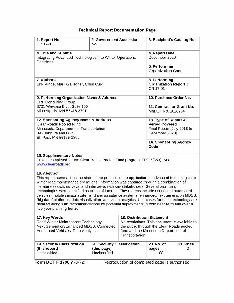
Technical Report Documentation Page
1. Report No. CR 17-01
2. Government Accession No.
3. Recipient’s Catalog No.
4. Title and Subtitle Integrating Advanced Technologies into Winter Operations Decisions
4. Report Date December 2020
5. Performing Organization Code
7. Authors Erik Minge, Mark Gallagher, Chris Curd
8. Performing Organization Report # CR 17-01
9. Performing Organization Name & Address SRF Consulting Group 3701 Wayzata Blvd, Suite 100 Minneapolis, MN 55416-3791
10. Purchase Order No.
11. Contract or Grant No. MnDOT No. 1028784
12. Sponsoring Agency Name & Address Clear Roads Pooled Fund Minnesota Department of Transportation 395 John Ireland Blvd St. Paul, MN 55155-1899
13. Type of Report & Period Covered Final Report [July 2018 to December 2020]
14. Sponsoring Agency Code
15. Supplementary Notes Project completed for the Clear Roads Pooled Fund program, TPF-5(353). See www.clearroads.org.
16. Abstract This report summarizes the state of the practice in the application of advanced technologies to winter road maintenance operations. Information was captured through a combination of literature search, surveys, and interviews with key stakeholders. Several promising technologies were identified as areas of interest. These areas include connected automated vehicles, mobile sensor systems, driver assistance systems, enhanced/next generation MDSS, “big data” platforms, data visualization, and video analytics. Use cases for each technology are detailed along with recommendations for potential deployments in both near term and over a five-year planning horizon.
17. Key Words Road Winter Maintenance Technology, Next Generation/Enhanced MDSS, Connected Automated Vehicles, Data Analytics
18. Distribution Statement No restrictions. This document is available to the public through the Clear Roads pooled fund and the Minnesota Department of Transportation.
19. Security Classification (this report) Unclassified
20. Security Classification (this page) Unclassified
20. No. of pages
88
21. Price -0-
Form DOT F 1700.7 (8-72) Reproduction of completed page is authorized

Final Report
Integrating Advanced Technologies into Winter Operations Decisions
Clear Roads Project No. 17-01
Prepared by:
November 2020
SRF No. 10940

Table of Contents
Executive Summary ............................................................................................................... 1
Project Overview ............................................................................................................................................... 1
Project Findings ................................................................................................................................................. 1
Survey Results ....................................................................................................................................... 1
Interviews .............................................................................................................................................. 2
“Big Data” Tool Analysis .................................................................................................................... 3
Recommendations ............................................................................................................................................. 3
Mobile Sensor Systems ........................................................................................................................ 3
Driver Assistance Systems .................................................................................................................. 4
Connected and Autonomous Vehicle (CAV) Systems ................................................................... 4
Video Analytics ..................................................................................................................................... 5
Communications Systems ................................................................................................................... 5
MDSS/EMDSS/NGMDSS ............................................................................................................... 5
Crowdsourced Data ............................................................................................................................. 6
Data Analysis and Management ......................................................................................................... 6
Acknowledgements ............................................................................................................... 8
List of Abbreviations .............................................................................................................. 9
Introduction ........................................................................................................................... 11
State of Practice Overview .................................................................................................. 12
Literature Search .............................................................................................................................................. 12
Introduction ........................................................................................................................................ 12
Vehicle Systems: ................................................................................................................................. 12
Roadside Systems: .............................................................................................................................. 12
Communication Systems: .................................................................................................................. 12
Back-Office Systems: ......................................................................................................................... 12
Vehicle Based Systems ....................................................................................................................... 12
Condition Sensors .............................................................................................................................. 12
Pavement Sensor Evaluations ...................................................................................................... 13
Clear Roads 17-01 Integrating Advanced Technologies into Winter Operations Decisions SRF Consulting Group i

Pilot Deployments of Mobile Road Weather Information Systems (RWIS) ........................ 13
Salt Sensors ..................................................................................................................................... 14
Tire-Embedded Friction Sensors ................................................................................................ 14
Vehicle and Equipment Control Systems ....................................................................................... 14
Collision Avoidance ...................................................................................................................... 14
Cooperative Collision Avoidance Model for Connected Vehicles .................................... 14
Impending Bridge Impact Warning System for Prevention of Snowplow-Bridge Impacts ....................................................................................................................................... 15
Collision Avoidance and Mitigation System on Winter Maintenance Trucks.................. 15
Autonomous Control .................................................................................................................... 15
Autonomous Airport Plowing................................................................................................. 15
Institute of Navigation Autonomous Snowplow Competition .......................................... 16
Localizing Ground Penetrating RADAR (LGPR): A Step Toward Robust Autonomous Ground Vehicle Localization .................................................................................................. 16
Driver Assistance Technology .......................................................................................................... 17
Gang Plowing Using Differential GPS ....................................................................................... 17
Lane Boundary Guidance System ............................................................................................... 17
Augmented Reality Head-Up-Displays ....................................................................................... 17
Automated Salt Spreader Systems ............................................................................................... 18
Video Systems ..................................................................................................................................... 18
Roadside Systems ............................................................................................................................... 19
Weather Sensors ................................................................................................................................. 19
Non-Invasive Pavement Sensors ................................................................................................. 20
Camera Systems ............................................................................................................................. 20
Traffic Signal Systems ........................................................................................................................ 20
Snowplow Signal Priority .............................................................................................................. 20
Signal Timing Optimization .............................................................................................................. 21
Heated Pavement Technologies ....................................................................................................... 22
Weather Monitoring Drone Systems ............................................................................................... 23
Communication Systems ................................................................................................................... 23
Cellular Systems .................................................................................................................................. 23
5G .................................................................................................................................................... 23
Low-Power Wide-Area Network ..................................................................................................... 24
Clear Roads 17-01 Integrating Advanced Technologies into Winter Operations Decisions SRF Consulting Group ii
Narrowband LTE Technologies ................................................................................................. 24
Ultra Narrowband ......................................................................................................................... 25
LoRa ................................................................................................................................................ 25
Satellite Systems .................................................................................................................................. 25
Existing Satellite Systems .............................................................................................................. 26
Planned Satellite Systems .............................................................................................................. 26
Back-Office Systems ............................................................................................................ 29
New and Improved Data Sources ................................................................................................................. 30
Video Analytics ................................................................................................................................... 30
Connected Vehicles............................................................................................................................ 30
Crowdsourcing Data .......................................................................................................................... 30
Consumer Weather Stations ........................................................................................................................... 31
Community Data Sources ............................................................................................................................... 31
Data Processing ................................................................................................................................................ 32
Big Data ............................................................................................................................................... 32
Cloud Computing and Edge Computing ........................................................................................ 32
Artificial Intelligence and Machine Learning ................................................................................. 33
Data Utilization ................................................................................................................................................ 34
Real-Time Route Optimization ........................................................................................................ 34
Improved Deicing Material Recommendations ............................................................................. 34
Travel Time Predictions and Improvements ................................................................................. 35
Improved Performance Measures ................................................................................................................. 35
Conclusion ........................................................................................................................................................ 36
Bibliography ...................................................................................................................................................... 36
Survey ..................................................................................................................................... 37
Methodology ..................................................................................................................................................... 37
Respondents ..................................................................................................................................................... 37
Questionnaire ................................................................................................................................................... 39
Results and Analysis ........................................................................................................................................ 41
Sensors: ................................................................................................................................................ 41
Cameras: .............................................................................................................................................. 41
Clear Roads 17-01 Integrating Advanced Technologies into Winter Operations Decisions SRF Consulting Group iii

Video Analytics ................................................................................................................................................ 43
Communications .............................................................................................................................................. 44
Maintenance Decision Support Systems ...................................................................................................... 45
Crowdsourced Data ......................................................................................................................................... 46
Data Analytics .................................................................................................................................................. 46
Technology Research and Planning .............................................................................................................. 47
Analysis .............................................................................................................................................................. 49
Conclusions ....................................................................................................................................................... 50
Follow-Up Interviews ............................................................................................................ 52
Interview Summaries ........................................................................................................... 52
Kentucky Transportation Cabinet ................................................................................................................. 52
Interview Subjects .............................................................................................................................. 52
Reasons for Selection ......................................................................................................................... 52
Deployment Summary ....................................................................................................................... 52
Questions and Responses ................................................................................................................. 52
Big Data Applications ........................................................................................................................ 52
Data Visualizations and Other Data Usage .................................................................................... 54
Other Comments ............................................................................................................................... 54
Idaho Transportation Department ................................................................................................................ 55
Interview Subjects .............................................................................................................................. 55
Reasons for Selection ......................................................................................................................... 55
Deployment Summary ....................................................................................................................... 55
Questions and Responses ................................................................................................................. 55
Vaisala Mobile RWIS ......................................................................................................................... 55
Wing Plow Camera System ............................................................................................................... 56
Other Comments ............................................................................................................................... 57
Iowa Department of Transportation ............................................................................................................ 57
Interview Subject ................................................................................................................................ 57
Reasons for Selection ......................................................................................................................... 57
Deployment Summary ....................................................................................................................... 57
Questions and Responses ................................................................................................................. 57
Clear Roads 17-01 Integrating Advanced Technologies into Winter Operations Decisions SRF Consulting Group iv
Partnership with SAS ......................................................................................................................... 57
Data Visualizations ............................................................................................................................. 58
New York State DOT ..................................................................................................................................... 58
Interview Subject ................................................................................................................................ 58
Reasons for Selection ......................................................................................................................... 59
Deployment Summary ....................................................................................................................... 59
Questions and Responses ................................................................................................................. 59
NGMDSS Efforts .............................................................................................................................. 59
Other Topics ....................................................................................................................................... 60
Other Comments ........................................................................................................................... 60
Norwegian Public Roads Administration ..................................................................................................... 60
Interview Subject ................................................................................................................................ 60
Reasons for Selection ......................................................................................................................... 60
Deployment Summary ....................................................................................................................... 60
Questions and Responses ................................................................................................................. 61
Vaisala Road AI .................................................................................................................................. 61
Avinor AV Applications .................................................................................................................... 62
Automatic Spreading ......................................................................................................................... 62
Other Comments ............................................................................................................................... 62
Summary of Findings ......................................................................................................................... 62
Data Analytics (Big Data) Tool Summary ......................................................................... 64
Introduction ...................................................................................................................................................... 64
Real time decision making:................................................................................................................ 64
Scalability and prediction opportunities: ......................................................................................... 64
Components and Tools................................................................................................................................... 64
Choosing Tools and Deployment Methods ................................................................................................. 70
Implementation Trade-offs ............................................................................................................................ 70
Hosting Options .............................................................................................................................................. 72
Total Cost of Ownership ................................................................................................................................ 73
Trade-offs of Advanced Database and File Systems .................................................................................. 74
Data Analytics in Winter Operations: Examples ........................................................................................ 76
Recommendations for Best Practices ........................................................................................................... 77
Clear Roads 17-01 Integrating Advanced Technologies into Winter Operations Decisions SRF Consulting Group v

Recommended Actions by Area ........................................................................................ 79
Mobile Sensor Systems .................................................................................................................................... 79
Recommendations .............................................................................................................................. 79
Driver Assistance Systems .............................................................................................................................. 80
Recommendations .............................................................................................................................. 80
Connected and Autonomous Vehicle (CAV) Systems ............................................................................... 80
Recommendations .............................................................................................................................. 81
Video Analytics ................................................................................................................................................ 81
Recommendations .............................................................................................................................. 81
Communication Systems ................................................................................................................................ 81
Recommendations .............................................................................................................................. 82
Crowdsourced Traffic and Weather Data .................................................................................................... 82
Recommendations .............................................................................................................................. 82
MDSS/EMDSS/NGMDSS ........................................................................................................................... 83
Recommendations .............................................................................................................................. 83
“Big Data” Platforms ...................................................................................................................................... 84
Recommendations .............................................................................................................................. 84
Visualization and Dashboard Tools .............................................................................................................. 84
Recommendations .............................................................................................................................. 84
Conclusion ............................................................................................................................. 86
Mobile Sensor Systems .................................................................................................................................... 86
Driver Assistance Systems .............................................................................................................................. 86
Connected and Autonomous Vehicle (CAV) Systems ............................................................................... 87
Video Analytics ................................................................................................................................................ 87
Communications Systems ............................................................................................................................... 87
Crowdsourced Data ......................................................................................................................................... 87
Data Analysis and Management ..................................................................................................................... 88
Clear Roads 17-01 Integrating Advanced Technologies into Winter Operations Decisions SRF Consulting Group vi

List of Figures
Figure 1- Survey Responses by State ............................................................................................................. 38 Figure 2- Survey Responses by County ........................................................................................................ 39 Figure 3- Flowchart of Survey Logic ............................................................................................................ 40 Figure 4- Sensors .............................................................................................................................................. 41 Figure 5- Cameras and Vehicle Systems ....................................................................................................... 42 Figure 6- Driver Assistance/Collision Avoidance Technology ................................................................ 42 Figure 7- Autonomous (Self-Driving) Technologies .................................................................................. 43 Figure 8- Connected Vehicle Technologies ................................................................................................. 43 Figure 9- Video Analytics and Road Surface Conditions .......................................................................... 44 Figure 10- Video Analytics and Weather Conditions ................................................................................. 44 Figure 11- Maintenance Decision Support Systems ................................................................................... 45 Figure 12- MDSS (EMDSS or NGMDSS) .................................................................................................. 45 Figure 13- Cloud Computing Services .......................................................................................................... 46 Figure 14- Artificial Intelligence .................................................................................................................... 46 Figure 15- Data Visualization Tools ............................................................................................................. 47 Figure 16-Shared Data Visualizations ........................................................................................................... 47 Figure 17- Ranked Interest in Advanced Technologies in Winter Operations ...................................... 49 Figure 18- Technology Index ......................................................................................................................... 50 Figure 19- Visual Representation of a Generic Stack ................................................................................. 66 Figure 20- Data Wrangling ............................................................................................................................. 67 Figure 21- Data Warehousing ........................................................................................................................ 68 Figure 22- Data Visualization ......................................................................................................................... 69 Figure 23- Example Data Visualization, Analytics and Reporting Tools ................................................ 70 Figure 24- SWOT Analysis: In-House .......................................................................................................... 71 Figure 25- SWOT Analysis: Third Party Solution ....................................................................................... 72 Figure 26- On- Premises vs. Cloud Computing .......................................................................................... 73 Figure 27- Cloud vs. On-Premise: Advantages and Drawbacks ............................................................... 74 Figure 28- RDBMS vs Distributed Systems ................................................................................................ 75 Figure 29- Analysis Approach ........................................................................................................................ 76 Figure 30- Methodology ................................................................................................................................. 77
Clear Roads 17-01 Integrating Advanced Technologies into Winter Operations Decisions SRF Consulting Group vii

List of Tables
Table 1- Technology Research and Planning............................................................................................... 48
Clear Roads 17-01 Integrating Advanced Technologies into Winter Operations Decisions SRF Consulting Group viii

Executive Summary
Project Overview
Clear Roads initiated Project 17-01 Integrating Advanced Technologies into Winter Operations Decisions to explore the state of the practice of winter roadway operations across the country. The goal of the project is to produce a set of best practices and recommendations that draw from both current and future deployments that employ emerging technologies. This was accomplished through a combination of literature search, surveys and interviews with key stakeholders.
Several technologies were identified as areas with opportunities for innovation in the field of winter maintenance. These technologies are detailed further in the report and recommendations have been created for each technology. Particular focus was given to the development of “big data” platforms and other data management tools and software stacks.
This document serves as the Final Report for Clear Roads Project 17-01. This report is a synthesis of the information presented in previous project reports and technical memos. This Executive Summary provides a high-level overview of the main project activities and findings.
Project Findings
Survey Results A survey of roadway maintenance agencies was conducted to determine the level to which they use technology to assist their winter maintenance activities. Survey responses were received from 33 different agencies. Key takeaways include the following:
• Emerging technologies such as Automated Vehicles (AV), Connected Vehicles (CV), 5G,and machine learning are currently of little interest to most agencies, often due to the lack ofexisting infrastructure needed to deploy them. However, some key agencies are activelyresearching or pursuing these technologies, such as route-based forecasting, automatedspreading, and the use of big data services. Those agencies pursuing unique research projectswere the focus of the follow-up interviews.
• Cellular communication over 3G, 4G, or LTE networks was by far the most common meansof communication to field equipment, both for vehicles and stationary roadside equipment.However, as 3G and non-LTE 4G services are phased out by carriers, the pursuit of 5Gtechnology will be crucial to the ongoing operations of many agency’s advanced wintermaintenance technologies.
• Agencies that use Maintenance Decision Support Systems (MDSS) frequently supplementthese services with external weather data, traffic data, and analysis tools. Most agencies usesome form of data to support their maintenance operations.
Clear Roads 17-01 Integrating Advanced Technologies into Winter Operations Decisions SRF Consulting Group 1

• Ultimately, advanced technologies are still an emerging space for many agencies, and whileoverall the winter maintenance field is not a vanguard for these technologies at this time,several key agencies were found to be following industry trends and progressive researchprojects.
Interviews Follow-up interviews were conducted with several agencies that reported interesting use cases or were planning pilot projects. Interviews were conducted with the following agencies, also listed are the areas of interest.
• Kentucky Transportation Cabinet (KYTC), use of big data platforms
• Idaho Transportation Department (ITD), mobile RWIS pilot project
• Iowa Department of Transportation (DOT), future road condition predictions
• New York State (NYS) DOT, use of Next Generation MDSS
• Vegvesen/Norwegian Public Roads Administration, use of Vaisala Road AI equipment
Insights gained from these interviews include the following:
• KYTC’s robust self-developed big data platforms assist its winter maintenance team bycollecting data from various sources and displaying it in a manner that is effective forpreparation for winter events as well as post-storm analysis. KYTC is looking to expands itssystem to address other winter maintenance use cases and potentially serve otherdepartments within KYTC.
• ITD’s pilot project with Vaisala’s mobile RWIS system was successful and ITD is looking tomove forward with greater implementation of the system when Vaisala produces its secondgeneration of devices. The system has helped with efficiency of spreading operations byproviding plow drivers with real-time information on road conditions.
• Iowa DOT’s pilot project with SAS for future road conditions has had mixed results. Whilethe system has run into issues with data formatting and lack of data, causing the system to beunable to produce predictions, the Iowa DOT is exploring several options for providing datato 511 services, including this pilot and its Pikalert system.
• NYSDOT’s pursuit of a next-generation MDSS system has been very limited to date. Suchtechnology may not yet be at a state when it can be effectively integrated into wintermaintenance operations.
• Vegvesen’s pilot with the machine learning-based Vaisala Road AI product has beensuccessful in analyzing pavement conditions during winter months and will be expanded toinclude additional winter maintenance applications.
Clear Roads 17-01 Integrating Advanced Technologies into Winter Operations Decisions SRF Consulting Group 2

“Big Data” Tool Analysis Data analytics tools used for analysis of winter maintenance operations were examined to determine the state of the practice and opportunities for future developments. This led to the creation of a set of best practices for incorporating these tools into future operations.
These best practices are as follows:
• Create an internal agency culture that is comfortable interacting with data visualization and reporting tools (change management). Expose staff to these tools whenever possible.
• Invest in in-house staff capabilities without over-committing resources.
• Invest heavily in identifying potential Key Performance Indicators (KPIs) which drive data collection and the entire analytics process (imagine the unimagined).
• Do not over-commit long-term to any one tool, stack, or vendor ecosystem (the field is rapidly advancing). Build in flexibility to accommodate change.
• Beware of vendors over-hyping analytics technology solutions that do not have domain knowledge of winter operations or transportation systems in general.
• Combine resources with other agencies to mitigate investment costs.
• Identify Total Cost of Ownership (TCO) metrics to measure true organizational cost impact, not just initial costs.
Recommendations
Survey, interview and literature finders were synthesized to create the following set of recommendations for winter maintenance agencies going forward. Recommendations are made for each of the focus areas presented above.
Mobile Sensor Systems Improvements in weather sensor technology have enabled moving winter maintenance vehicles to collect road condition observations directly from the field. Commonly referred to as mobile Road Weather Information Systems (RWIS), these systems allow the collection of weather and pavement condition information over a large geographic area without requiring extensive deployments of roadside infrastructure. Installation of such sensors on snowplows provides agencies with improved data collection capabilities, helping with real time decisions for maintenance operations. Since sensors are vehicle-mounted, systems can be maintained at a central facility which simplifies maintenance when compared to embedded pavement sensors. This reduces the potential down time due to hardware failure.
Weather and road surface condition sensors have been used on vehicles for several years. They have also been evaluated by Clear Roads and found to be generally accurate and effective. However, while vehicle-mounted sensors were found to excel at certain activities such as determining pavement temperature and the existence of moisture on pavement, sensors currently available have trouble
Clear Roads 17-01 Integrating Advanced Technologies into Winter Operations Decisions SRF Consulting Group 3

distinguishing between snow and ice, and are unable to determine the depth of water on pavement. In addition, high costs make widespread deployment impractical for most agencies. Prices are anticipated to decline, but not to the point where universal deployment is viable. Agencies should consider equipping supervisor or specific vehicles that operate on routes with highly variable weather or road surface conditions.
Driver Assistance Systems Driver assistance systems include technologies such as aftermarket camera systems that monitor plow and spreader operations, driver assistance technologies such as collision warning, and automated salt spreading. These technologies improve safety during winter maintenance operations by providing vehicle operators with additional information about the conditions surrounding their vehicle and handling some of the operator’s functions for them, such as salt spreading, enabling the operator to stay focused on driving.
Collision avoidance, lane keeping, and camera systems have become commonplace on passenger vehicles, but currently only camera systems are widely used on winter maintenance vehicles. These commonly include rear-view, spreader, and plow monitoring cameras with a dash-mounted display for the driver. Reaction has generally been very positive and some fleets are now working toward universal deployment. The specific camera equipment chosen was found to be important for success. Cameras should always include a washer system, and ideally, a heated lens system. Installation must carefully consider cable routing and connector type as vibration and contamination can easily damage the system wiring.
Connected and Automated Vehicle (CAV) Systems CV systems involve communication and transmission of data either between two vehicles (vehicle to vehicle, or V2V) or between a vehicle and another stationary device (vehicle to infrastructure, or V2I). To date, CV applications have commonly used Dedicated Short-Range Communications (DSRC) wireless communications. DSRC is based on the IEEE 802.11p standards and is designed to establish connections between moving vehicles quickly enough to allow for data to be exchanged before they move out of range. The emergence of 5G cellular communication may provide another avenue for CV communications.
AV systems involve vehicles moving and operating with minimal or no input from drivers. AV technology is still in its infancy with respect to the winter maintenance field; however, several projects involving automated airport runway sweepers were discovered to be underway, including one being undertaken by Vegvesen.
Possible CAV applications include collision avoidance, precision formation driving (gang plowing) and traffic signal priority. Several CAV pilot deployments on winter maintenance vehicles are currently underway. However, the current generation of technology has been challenging to properly integrate with roadside infrastructure, such as traffic signal controllers. The underlying communications technology (DSRC or 802.11p) may also be supplanted by emerging versions of 5G cellular and ad-hoc networking systems. Unless an agency has specific uses for CAV technologies
Clear Roads 17-01 Integrating Advanced Technologies into Winter Operations Decisions SRF Consulting Group 4

and technical capacity to integrate systems, deployments in the short term should focus on evaluation of CAV technologies rather than broad deployment.
Video Analytics Video analytics refers to the use of video cameras to automate collection of data such as road conditions from stationary or vehicle-mounted cameras. This often includes approaches involving the use of machine learning or artificial intelligence (AI) systems to process the imagery obtained from cameras. The software to analyze and extract information from video streams is rapidly advancing, and weather-related application are now commercially available. Generally, parameters such as visibility, precipitation and road surface condition can be derived from a video stream. Analyzing data obtained from video analytics at a central site requires the ability to transmit video from the camera; however, transmitting video from multiple vehicles poses bandwidth limitations, particularly if only a 3G cellular network is available. Generally, analytics will be licensed “as a service” based on the number of cameras analyzed, frequency of updates, etc. Video analytics may be most appropriate where there is no existing RWIS equipment and reliable, high bandwidth (> 1 Mbit/sec) are available.
Communications Systems Communication systems for winter maintenance vehicles fall into two categories: mobile communication used primarily in vehicles, and fixed (roadside) systems which typically use wireless or fiber optic communication to permanent infrastructure. Cellular data systems are commonly used and anticipated to be the predominate communication system for mobile and roadside devices for winter maintenance. The cellular system is evolving with the deployment of 5G technology, which offers the promise of higher-bandwidth, more flexible connection and in some cases, greater coverage. Deployment of 5G has been uneven and the differing underlying technologies used has made performance unpredictable. At the same time, new forms of connectivity like Low Earth Orbit (LEO) satellite systems are entering a new generation of technology. LEO promises to make high-bandwidth connections to remote, stationary systems much cheaper and more accessible.
MDSS/EMDSS/NGMDSS The use of MDSS by state DOTs and other agencies to inform winter maintenance operations decisions has grown in popularity in recent years. These systems take data obtained from RWIS, on-vehicle mobile sensors, stationary in-pavement sensors, crowdsourced traffic and weather data, and other sources; this data is then analyzed to provide vehicle operators with priority areas to target for maintenance as well as suggesting materials appropriate for treatment. Interest in continuing to build in these platforms has led to the concept of an “Enhanced” or “Next-Generation” MDSS (EMDSS/NGMDSS). The factors separating an EMDSS/NGMDSS from a standard MDSS are still fairly abstract; however, generally an EMDSS/NGMDSS implements CV applications to enhance data analytics.
Clear Roads 17-01 Integrating Advanced Technologies into Winter Operations Decisions SRF Consulting Group 5

Crowdsourced Data A technological trend that has already led to widespread benefits is the advent of crowdsourced data. Technology like smartphones and in-vehicle GPS receivers has allowed information service companies like Google and INRIX, as well as open-source projects like OpenStreetMap, to collect information from their users to improve their services, such as the use of real-time traffic information or user-submitted road closure reports to improve route recommendations. This data collection model has been adapted to collect weather data as well, by organizations such as Weather Underground, AccuWeather, the National Weather Service (via mPing) and the Community Collaborative Rain, Hail, and Snow Network. Utah DOT has also created a Citizen Reporting program that fulfills this purpose within the state of Utah.
Leveraging the ability of the general public to observe and report has become commonplace with the wide proliferation of smartphones. Agencies can leverage this data to supplement sensor networks and staff reports from the field. Including the ability to report weather or road conditions in an application appears to see greater adoption and generate more data than a dedicated, agency-provided app. Agencies should seek partnerships with the providers of commonly used applications to obtain data they already collect, or to add reporting functionality. This may provide a more cost-effective approach that produces more data than creating a new application.
Data Analysis and Management Software such as ArcGIS and Tableau can take winter maintenance data as input to create easy-to-understand data visualizations, such as maps showing areas of high traffic or maps showing pavement temperatures over a wide area to indicate areas where maintenance is most needed. These visualizations are critical when presenting data to the public to effectively communicate conditions in a manner able to be understood by laymen.
Data can also be summarized into dashboards typically utilized by maintenance staff and management. These platforms allow operators to easily interpret large amounts of data by providing easy-to-understand visual summaries of data pertinent to the user, such as summaries of pavement temperatures or storm severity in a particular area.
The variety of data sources used in the winter maintenance field generate large, continuous data streams that frequently require large amounts of computing power to process in an effective manner. “Big Data” refers to a broad set of platforms that use these large datasets to identify patterns or trends that can help predict events or improve services. This often involves the use of distributed computing systems to help manage the size of these datasets, which may be too big to process or store with a single machine. In the winter maintenance field, these platforms are used to enhance tools such as an agency’s MDSS to produce more efficient maintenance applications.
The tools to store, analyze and visualize very large amounts of data have become more affordable and simpler to use. Databases with billions of records can now be transformed and fused with other data sources using freely available software. These tools can be complex to configure and program, however. Feedback from existing agency users of “big data” tools indicate that even with the
Clear Roads 17-01 Integrating Advanced Technologies into Winter Operations Decisions SRF Consulting Group 6

complexity of the tools, in-house development is preferable as this has results in applications being created faster and more closely tailored to their needs than using external consultants.
Many agencies already have substantial technical expertise from working with AVL and GIS systems. This knowledge and the existing set of tools should be leveraged and augmented with newer data dashboarding and analysis tools like Spark, Rshiny and other data “stack” elements. Staff should be offered training opportunities to use these newer tools.
Clear Roads 17-01 Integrating Advanced Technologies into Winter Operations Decisions SRF Consulting Group 7

Acknowledgements
The project committee and research team would like to acknowledge and thank the following:
• Greg Waidley, Clear Roads Research Program and Project Manager
• Tom Peters, Minnesota Department of Transportation
• Jon Fleming, Pennsylvania Department of Transportation
• Scott Simons, Maryland Department of Transportation
• Todd Law, Vermont Agency of Transportation
• John DeCastro, Connecticut Department of Transportation
• Melissa Longworth, Michigan Department of Transportation
• Randi Feltner, Kentucky Transportation Cabinet
• Jeremy Gould, Kentucky Transportation Cabinet
• Steve Spoor, Idaho Transportation Department
• Max Thieme, Idaho Transportation Department
• Tina Greenfield Huitt, Iowa Department of Transportation
• Joe Thompson, New York State Department of Transportation
• Kai Rune Lysbakken, Vegvesen (Norwegian Public Roads Administration)
Clear Roads 17-01 Integrating Advanced Technologies into Winter Operations Decisions SRF Consulting Group 8
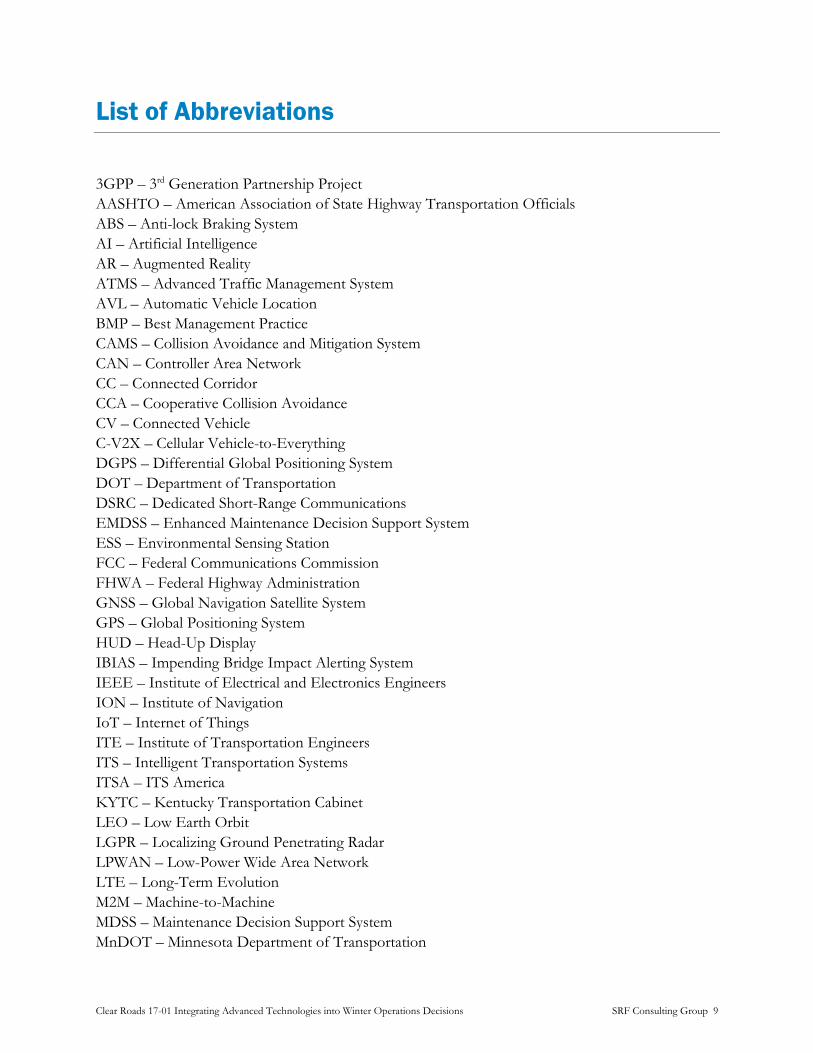
List of Abbreviations
3GPP – 3rd Generation Partnership Project AASHTO – American Association of State Highway Transportation Officials ABS – Anti-lock Braking System AI – Artificial Intelligence AR – Augmented Reality ATMS – Advanced Traffic Management System AVL – Automatic Vehicle Location BMP – Best Management Practice CAMS – Collision Avoidance and Mitigation System CAN – Controller Area Network CC – Connected Corridor CCA – Cooperative Collision Avoidance CV – Connected Vehicle C-V2X – Cellular Vehicle-to-Everything DGPS – Differential Global Positioning System DOT – Department of Transportation DSRC – Dedicated Short-Range Communications EMDSS – Enhanced Maintenance Decision Support System ESS – Environmental Sensing Station FCC – Federal Communications Commission FHWA – Federal Highway Administration GNSS – Global Navigation Satellite System GPS – Global Positioning System HUD – Head-Up Display IBIAS – Impending Bridge Impact Alerting System IEEE – Institute of Electrical and Electronics Engineers ION – Institute of Navigation IoT – Internet of Things ITE – Institute of Transportation Engineers ITS – Intelligent Transportation Systems ITSA – ITS America KYTC – Kentucky Transportation Cabinet LEO – Low Earth Orbit LGPR – Localizing Ground Penetrating Radar LPWAN – Low-Power Wide Area Network LTE – Long-Term Evolution M2M – Machine-to-Machine MDSS – Maintenance Decision Support System MnDOT – Minnesota Department of Transportation
Clear Roads 17-01 Integrating Advanced Technologies into Winter Operations Decisions SRF Consulting Group 9

NIPS – Non-Invasive Pavement Sensor RTK – Real-Time Kinematic RWIS – Road Weather Information System SPaT – Signal Phase and Timing SRM – Signal Request Message SSM – Signal Status Message UNB – Ultra Narrowband V2I – Vehicle-to-Infrastructure V2V – Vehicle-to-Vehicle VDT – Vehicle Data Translator WAN – Wide Area Network
Clear Roads 17-01 Integrating Advanced Technologies into Winter Operations Decisions SRF Consulting Group 10

Introduction
Clear Roads is a research organization comprised of 36 agencies that pool resources to conduct research on winter maintenance operations. Since its inception in 2004, the Clear Roads research program has provided forward looking guidance for implementing new practices and technologies for winter maintenance.
Several reports and technical memos were produced over the course of the project and are summarized in this final report. First, a literature review was conducted to understand and present the current technologies in use as well as uses for and tests of emerging technologies. A survey of winter maintenance agencies and organizations was conducted to determine which advanced technologies they have in use or have explored, and these responses helped identify trends throughout the industry. Follow-up interviews were conducted with respondents who provided responses of particular interest to obtain a deeper look at innovative projects and applications. A summary of data analytics tools and software stacks with winter maintenance applications was also produced. The results of all of these tasks were then synthesized into a set of recommendations for both immediate uses and long-term outlooks for a variety of winter maintenance technologies.
Clear Roads 17-01 Integrating Advanced Technologies into Winter Operations Decisions SRF Consulting Group 11
State of Practice Overview
Literature Search
Introduction The rapid advance of technology promises to improve the safety and efficiency of winter maintenance operations. Literature was reviewed from various sources, located through online searches, conference proceedings, collections of research by federal agencies, and recommendations from the project panel. A 5-10 year planning horizon was used for analysis to provide a vision of technological advances that may affect winter operations in the not too distant future. In general documents were limited to the previous 5 years to minimize outdated information, though in some cases leading work that was older than this was included.
To manage the wide variety of possible topics, the literature search concentrated on four areas that have shown rapid evolution over the last five years:
Vehicle Systems: On board sensing, vehicle control, information display and device management.
Roadside Systems: Sensor networks, traffic control and information displays.
Communication Systems: Terrestrial and satellite systems that move data between vehicles, roadside systems and back-end data processing services.
Back-Office Systems: Data processing for maintenance recommendations (similar to MDSS, data fusion and visualization).
Each of these areas has several sub-categories of emerging technologies. These are delineated in the following sections.
Vehicle Based Systems Vehicle based systems include those that monitor conditions and those integrated into the control systems of the vehicle itself. Condition sensing technology focuses on improving the effectiveness of maintenance activities, where control systems are generally meant to improve the safety of operations or reduce operator workload.
Only technologies on maintenance vehicles were considered in this literature search. Other approaches, such as probe vehicle data from third party providers was considered outside the scope of the literature search.
Condition Sensors
Sensor technology has progressed so that high-quality meteorological and pavement condition sensors can return data from moving vehicles. This allows for much greater coverage compared to
Clear Roads 17-01 Integrating Advanced Technologies into Winter Operations Decisions SRF Consulting Group 12

fixed sensor stations and can provide information in real-time to operators. Despite these benefits, however, this technology is still expensive, and, as discussed below, sensor performance is not at the level required to make them useful to winter maintenance operations decisions.
Pavement Sensor Evaluations
Clear Roads (CR 16-03) has tested the accuracy of commercially available mobile pavement sensor technologies that measure the friction of the roadway and other weather conditions.1
The testing showed that all sensors had considerable room for improvement. They generally fail to meet the desired level of accuracy expected by maintenance personnel (1-3%) and generally fail to meet the “lab” results claimed by the vendor. In particular, commercially available sensors have difficulty determining the depth of water found on the pavement, and have trouble distinguishing between ice and snow.
Sensors also lack a standard format for reporting data. An example is that each sensor has its own terminology for describing pavement conditions (ice, snow, wet, dry, etc.), making it difficult to compare data from devices made by different manufacturers. There is also varying compatibility with these sensors and external systems, such as the Maintenance Decision Support Systems (MDSS) or Automatic Vehicle Location (AVL) systems frequently used by agencies.
Despite these issues, these sensors are promising. Over time, these sensors are expected to improve, both in terms of performance and interoperability with other systems, especially as more agencies test deployments and provide feedback to vendors. This technology may become a valuable asset for improving winter maintenance operations.
Pilot Deployments of Mobile Road Weather Information Systems (RWIS)
The Alberta Ministry of Transportation deployed a Lufft MARWIS-UMB system on two vehicles over the 2015-2016 winter season.2 sensors were installed on two vehicles used for routine patrols of winter road conditions. The system uploaded data automatically, providing more timely updates and enabled more informed decisions for maintenance operations such as plow dispatching.
The Colorado Department of Transportation also began experimenting with road friction sensors in winter of 2017 to help with maintenance decisions.3 The results from small-scale
1 SRF. (2019). Mobile Technologies for Assessment of Winter Road Conditions. Clear Roads Project No. 16-03.
2 Alberta Transportation. (2016). Mobile Road Weather Information System Pilot Report. Retrieved from.
3 Reilly, Shalice. (2018, October 2). Friction Sensors Help CDOT Save Money and Improve Winter Road Safety. Retrieved from
https://www.codot.gov/business/process-improvement/larger-process-improvement-efforts/friction-sensors.
Clear Roads 17-01 Integrating Advanced Technologies into Winter Operations Decisions SRF Consulting Group 13
tests have been promising, and they have begun soliciting bids from vendors to procure an additional 28 sensors to be installed over two phases.
Salt Sensors
Sensors are available for measuring the salinity of moisture on the pavement,.4 This technology has been available for fixed RWIS sensors, but is not currently available on any commercial mobile RWIS system.5
Tire-Embedded Friction Sensors
Commercially-available mobile pavement friction sensors generally use either a physical probe to directly measure friction, or an optical-based sensor to infer it based on how light scatters off the surface. A more novel alternative to these technologies uses sensors embedded in a tire to measure friction.6 Though most of these technologies are still in the research phase, the possibility of measuring road friction without protruding equipment is interesting and may be a valuable data source in the future.
Vehicle and Equipment Control Systems
Several emerging technologies promise to automate aspects of vehicle or equipment control, better inform operators and utilize wireless communication to exchange data between vehicles. Though new, they are rapidly evolving and may be applicable to winter maintenance.
Collision Avoidance
While largely still experimental, vehicle-based collision avoidance systems have the potential to improve the safety of winter maintenance operations and reduce disruptions caused by crashes.
Cooperative Collision Avoidance Model for Connected Vehicles Modern vehicles frequently have brake-assist technology to automatically apply vehicle brakes. A related approach using (V2V) technology was tested by researchers in China for a cooperative collision avoidance (CCA) system that enabled “platooning” of vehicles by prompting the leading
4 Iwata, H., Yamamoto, K., Nishiduka, K., Higashi, H., Nakao, S., & Miyazaki, Y. (2008). Development of an on-vehicle type salinity
measurement sensor for controlling winter roadway surfaces. International Journal of ITS Research, 2(1).
5 Fay, L., Akin, M., Muthumani, A., Shi, X. (2018). Quantifying Salt Concentration on Pavement: Phase II. Retrieved from
https://intrans.iastate.edu/app/uploads/2018/10/quantifying_pvmt_salt_concentration_phase_II_w_cvr.pdf.
6 Khaleghian, S., Emami, A., & Taheri, S. (2017). A technical survey on tire-road friction estimation. Friction, 5(2), 123-146.
Clear Roads 17-01 Integrating Advanced Technologies into Winter Operations Decisions SRF Consulting Group 14

vehicle to accelerate and a trailing vehicle to brake. 7 This CCA technology requires further study to determine its practicality, but it could prove useful for snow plows, especially when traveling in gang plowing formations.
Impending Bridge Impact Warning System for Prevention of Snowplow-Bridge Impacts The University of Minnesota – Duluth evaluated the use of an obstacle detection system called the Impending Bridge Impact Alerting System (IBIAS) on Minnesota Department of Transportation (MnDOT) snowplows in northern Minnesota during the winter of 2007-2008.8 This system used warned the driver of low-clearance bridges that would collide with a raised dump box. The hardware cost of the system was approximately $575 per unit, making larger scale deployments of the technology economically feasible.
Collision Avoidance and Mitigation System on Winter Maintenance Trucks The Michigan DOT performed a pilot evaluation of a Collision Avoidance and Mitigation System (CAMS) to help reduce the occurrence of rear-end collisions with plow trucks.9 The system, consisted of a rear-facing radar, camera, and warning light bar. The system detected when vehicles exceed a pre-specified time headway threshold, indicating danger of a collision, and activates the warning light bar to alert the approaching driver. While this system exhibited some issues during the evaluation, it still showed potential for benefits on driver behavior and a corresponding reduction in collisions.
Autonomous Control
A rapidly advancing area of research is fully autonomous winter maintenance vehicles. Winter conditions are particularly challenging, but the potential benefits of autonomous plowing systems could reduce the cost and improve g the responsiveness of winter maintenance activities.
Autonomous Airport Plowing Several private companies have been working with airport authorities and management companies to develop and test autonomous plowing systems for clearing snow from airports. Daimler10 is working wither airport management services company Fraport to test their technology at Pferdsfeld
7 Wang, P., Wu, W., Deng, X., Xiao, L., Wang, L., & Li, M. (2017). Novel Cooperative Collision Avoidance Model for Connected
Vehicles. Transportation Research Record: Journal of the Transportation Research Board, (2645), 144-156.
8 Lindeke, R. R., Katmale, H., & Verma, R. (2009). Impending Box Impact Warning System for Prevention of Snowplow-Bridge Impacts: A Final
Report of Investigations.
9 Zockaie, A., Saedi, R., Gates, T., Savolainen, P., Schneider, B., Ghamami, M., ... & Singh, H. (2018). Evaluation of a Collision Avoidance
and Mitigation System (CAMS) on Winter Maintenance Trucks (No. OR 17-103).
10 Mogg, T. (2017, October 19). Daimler Aims to Bring its Self-Driving Snowplows to Airports. Retrieved from
https://www.digitaltrends.com/cars/snowplows-driverless-daimler/.
Clear Roads 17-01 Integrating Advanced Technologies into Winter Operations Decisions SRF Consulting Group 15

airbase near Frankfurt, Germany. Yeti Snow Technology,11 tested their system at Fagernes Airport, Leirin in Norway.12 The system uses a platoon of vehicles to clear snow in formation to improve efficiency. In North America, the Winnipeg Airports Authority is working with Manitoba-based Northstar Robotics, Inc. and Airport Technologies, Inc. to convert an existing snowplow to operate autonomously to assist current snow-clearing staff.13
The work done in these pilots should help lay the groundwork for more robust autonomous snow plow technology that may one day be safe for use in road maintenance activities.
Institute of Navigation Autonomous Snowplow Competition The Institute of Navigation (ION) holds an Annual Autonomous Snowplow Competition each winter, inviting university and college students, as well as the general public, to design, build, and operate a fully autonomous snowplow to remove snow from a designated path.14 Unlike some of the other work in this area, which depends more on preprogrammed maps, the technology in this competition may be more suitable to the highly dynamic nature of winter maintenance operations on public roads.
Localizing Ground Penetrating RADAR (LGPR): A Step Toward Robust Autonomous Ground Vehicle Localization The Lincoln Laboratory at the Massachusetts Institute of Technology (MIT) developed a novel low-profile ultra-low power LGPR system in 2014 that showed greater resilience to disruption than current autonomous vehicle navigation systems such as GNSS and optical LIDAR/camera systems.15 LGPR systems penetrate deep into the ground and detect subsurface features, which are very stable over time, making them capable of providing navigation information that is less susceptible to transient sources of error. While there are still questions to be answered regarding the limitations of this technology before it is ready for widescale deployment, the unique benefits of it combined with the low cost make it attractive, especially if fused with other navigation technologies. Recently, MIT licensed this technology with Geophysical Survey Systems, Inc. to develop commercial prototypes for use by developers of autonomous vehicle systems, making it potentially available for winter maintenance applications in the near future.16
11 Mogg, T. (2018, March 21). Self-Driving Snowplows Are Clearing Runways at Airport. Retrieved from
https://www.digitaltrends.com/cars/autonomous-snowplow-norway/.
12 Yeti Snow Technology. (2018). Retrieved from https://www.yetisnowtech.com/about.
13 CBC News. (2018, October 3). Driverless Snowplow Coming to Winnipeg Richardson International Airport. Retrieved from
https://www.cbc.ca/news/canada/manitoba/autonomous-snow-removal-winnipeg-1.4848864.
14 Institute of Navigation, Inc. (2017). Objectives of the Autonomous Snowplow Competition. Retrieved from
http://www.autosnowplow.com/objectives.html.
15 Cornick, M., Koechling, J., Stanley, B., & Zhang, B. (2016). Localizing Ground Penetrating Radar: a step toward robust
autonomous ground vehicle localization. Journal of field robotics, 33(1), 82-102.
16 Ryan, D. (2017, July 18). Lincoln Laboratory Enters Licensing Agreement to Produce Its Localizing Ground-Penetrating Radar. Retrieved from:
http://news.mit.edu/2017/lincoln-laboratory-enters-licensing-agreement-to-produce-localizing-ground-penetrating-radar-0718.
Clear Roads 17-01 Integrating Advanced Technologies into Winter Operations Decisions SRF Consulting Group 16

Driver Assistance Technology
Driver assistance technologies offer a means to bridge the gap between the current state of technology and the future of automated vehicles. By providing drivers with more information than they currently have, by using electronic sensors or vehicle-to-vehicle (V2V) communication, safety and efficiency can be improved.
Gang Plowing Using Differential GPS
Gang Plowing is one method used by DOTs and other agencies to reduce the surface regain time on multilane roads. For this method to be successful, the formation of the snowplows must be very consistent. Keeping this spacing between the plows, however, can be difficult and increase driver stress.
To help keep plow formations tight, researchers at the University of Minnesota developed a Differential Global Positioning System (DGPS)-based gang plowing system that uses digital maps; V2V communication; radar; a laser scanner; a driver interface; and steering, brake, and throttle control for testing on MnDOT snowplows.17 To prevent crashes instigated by motorists trying to pass a snowplow, the system includes a virtual mirror which uses a scanning laser sensor, a computer and a driver visual display to replicate the function of an optical mirror. The virtual mirror detects the presence and location of vehicles adjacent to the plow, notifying the driver via the in-vehicle display. While the system performs well, the cost of this is likely fairly high, with high-accuracy GNSS receivers for vehicles typically costing over $10,000 per unit. If used for other navigation or control systems, however, the cost of this hardware may be more manageable.
Lane Boundary Guidance System
Reduced visibility can impact the driver’s ability to see the road, potentially causing safety issues and reducing the efficiency of the plowing operation. A recent project at the University of Minnesota developed a driver assist system that used high-accuracy GNSS receivers and digital maps to provide drivers with an interface to help stay on the road.18 A simple colored LED strip with arrows to indicate deviation from the lane centerline was used to indicate lane position. Feedback from operators was generally positive; operators found the main aspects of the system useful but provided some suggestions for improvements to the interface.
Augmented Reality Head-Up-Displays
In 2013, Fraunhofer IGD, a leading applied computer graphics research institution in Germany, developed a model to calibrate a head-up display (HUD) for augmented reality (AR) using a
17 Alexander, L., Gorjestani, A., & Shankwitz, C. (2005). DGPS-Based Gang Plowing.
18 Liao, C. F., Morris, N. L., Achtemeier, J., Alexander, L., Davis, B., Donath, M., & Parikh, G. (2018). Development of Driver Assistance
Systems to Support Snowplow Operations.
Clear Roads 17-01 Integrating Advanced Technologies into Winter Operations Decisions SRF Consulting Group 17

camera.19 AR could be very useful for winter maintenance operations when combined with HUD technology, as it can display lane lines or roadside objects on a driver’s windshield when visibility is low. Though the concept of a HUD for use in snowplow operations has been an area of research for some time,20 new developments make such systems easier to install and work with. With increased discussion by vehicle manufacturers of integrating HUD technology into vehicles,21 this technology could find its way into maintenance vehicles soon.
Automated Salt Spreader Systems
Material spreader systems have been the subject of Clear Roads research in recent years.22 Automated salt spreader systems are noteworthy because they are likely to be an important part of an advanced winter maintenance vehicle. Automated salt spreader systems, such as AEBI Schmidt’s Thermologic system,23 use road temperature measurements to adjust the salt application rates automatically with minimal input from the driver. Continued advancements of these systems may allow direct connections to back-office software like MDSS to further adjust application rates.
Video Systems
Many agencies collect information about their plow fleet through video systems installed on vehicles. Several state DOTs, including Minnesota,24 Iowa,25 and Michigan26 have installed forward-facing cameras on a portion of their fleet, with some agencies including in-cab cameras to monitor
19 Wientapper, F., Wuest, H., Rojtberg, P., & Fellner, D. (2013, October). A camera-based calibration for automotive augmented reality head-up-
displays. In Mixed and Augmented Reality (ISMAR), 2013 IEEE International Symposium on (pp. 189-197). IEEE.
20 Gorjestani, A., Alexander, L., Newstrom, B., Cheng, P. M., Sergi, M., Shankwitz, C., & Donath, M. (2003). Driver assistive systems for
snowplows.
21 Jablansky, J. (2017, February 7). Soon You’ll Never Have to Look at Your Phone in the Car Again. Retrieved from
https://www.thrillist.com/cars/nation/apple-carplay-heads-up-displays-car-phones.
22 Thompson, G., Thompson T. (2014, February 28). Clear Roads: Developing a Totally Automated Spreading System. Retrieved from
http://clearroads.org/wp-content/uploads/dlm_uploads/11-03-Totally-automated-spreader_final_report.pdf.
23 AEBI Schmidt. (2019). Thermologic. Retrieved from https://www.aebi-schmidt.com/en/products/de-icing/schmidt-thermologic-
system.
24 MnDOT Office of Maintenance Research. MnDOT Plow Cams – Overview. Retrieved from
https://dot.state.mn.us/maintenance/files/mor_bull/2017/feb2017.pdf.
25 Hart, J. and Bargfrede, C. (2014, February 27). Iowa DOT News Release – Plow Cams Now Online for All to See. Retrieved from
http://www.news.iowadot.gov/newsandinfo/2014/02/plow-cams-now-online-for-all-to-see-iatraffic.html.
26 Raven, B. (2016, December 14). MDOT allows anxious travelers to watch snow plows via webcam. Retrieved from
https://www.mlive.com/news/index.ssf/2017/12/snowplows_with_cameras_mdot.html.
Clear Roads 17-01 Integrating Advanced Technologies into Winter Operations Decisions SRF Consulting Group 18

the driver. Most of these systems also transmit images to the management center and/or make them available to the public via the DOT’s 511 website.
These systems often use high-bandwidth wireless communication technologies like 4G cellular to transmit live video to other locations.27 The commercial freight industry also uses such in-vehicle video systems, along with computer vision and other data to detect likely incidents and notify managers.28
More recently, agencies have expressed interest in using video systems to monitor a vehicle’s equipment, such as the plow, spreader, or other important hardware. Clear Roads is currently investigating expanding the use of video systems on winter maintenance vehicles.29 Such cameras could feasibly be combined with existing video systems to improve data collection regarding the state of maintenance vehicles and provide operators and managers with better information to make decisions.
Roadside Systems Roadside systems such as RWIS have long been part of winter maintenance. Advanced roadside sensors and traffic control systems that can be integrated with maintenance systems to aid in decision making or make operations more efficient.
Weather Sensors
A number of technologies can be included in fixed roadside weather stations, commonly called Environmental Sensing Stations (ESS).30 There are currently over 2,400 of these stations owned by state transportation agencies,31 so it will not be discussed here in detail. More recent developments offer the potential for obtaining real-time weather information using hardware that is easier to maintain than traditional sensing technologies.
27 Soehnchen, A. (2016, March 7). Video Surveillance in Public Transportation. Retrieved from
http://www.masstransitmag.com/article/12171666/video-surveillance-in-public-transportation.
28 Huff, A. (2018, September 11). Trimble Transportation Mobility Releases Product Updates. Retrieved from
https://www.ccjdigital.com/trimble-transportation-mobility-releases-product-updates/.
29 Aftermarket Cameras in Winter Maintenance Vehicles. Clear Roads Project No. 17-03.
30 Federal Highway Administration. Interactive Environmental Sensor Station Page. Retrieved from
https://ops.fhwa.dot.gov/weather/mitigating_impacts/interactive_ess.htm.
31 Federal Highway Administration. Surveillance, Monitoring, and Prediction. Retrieved from
https://ops.fhwa.dot.gov/weather/mitigating_impacts/surveillance.htm#esrw.
Clear Roads 17-01 Integrating Advanced Technologies into Winter Operations Decisions SRF Consulting Group 19
Non-Invasive Pavement Sensors
Traditional pavement sensors are embedded in the pavement and use wires to provide power and communication. These sensors are susceptible to damage from snow, ice, salt, other chemicals, and mechanical damage from snowplow blades. These sensors are also difficult to calibrate once installed, complicating the installation and maintenance of the devices. While these sensors can have fairly long life cycles, they generally require replacement when the road is resurfaced.
Non-invasive pavement sensors typically use infrared sensors to measure the pavement surface temperature and condition, allowing the sensors to collect information from the roadside. This has the benefit of making the sensors more accessible in the event they require servicing or replacing, however there are limitations to the technology. Heavy fog or objects can occlude the sensors, and sensor lenses may require cleaning. Installation specifications require the sensor be at a certain angle to the roadway. Despite these difficulties, the performance makes them a viable option for current deployments, and it is expected that these sensors will improve over time.32
Camera Systems
Owing to the widespread deployment of traffic cameras, the Federal Highway Administration (FHWA) has funded research into the automated extraction of weather information from camera imagery.33 With the advent of more recent Artificial Intelligence (AI) systems this has become a more active area of research, with some companies even offering commercial solutions.34 As this technology would typically require significant computing power to be operational, it will be discussed further in a later section.
Traffic Signal Systems
In addition to roadside sensors, road operators may be able to leverage new technologies along with existing traffic control infrastructure to enhance the efficiency of maintenance operations.
Snowplow Signal Priority
More recent traffic signal controllers are capable of giving priority to specific vehicles by modifying the time allocated to each phase at the intersection. Frequently used for transit vehicles, this technology could also be used with winter maintenance. The proprietary
32 Beyer, M. (2016, June 22). Comparison of In-Pavement Versus Non-Invasive Pavement Sensor Technologies. Presentation at the 2016 Western
States Forum, Yreka, CA.
33 Pisano, P. A. Automated Extraction of Weather Variables from Camera Imagery.
34 Vaisala. Weather Data with Computer Vision. Retrieved from https://www.vaisala.com/en/products/data-subscriptions-and-
reports/computer-vision-and-data-visualization/weather-data-cv.
Clear Roads 17-01 Integrating Advanced Technologies into Winter Operations Decisions SRF Consulting Group 20

Opticom system has been used to provide priority to vehicles,35 but more recently the advent of Dedicated Short-Range Communications (DSRC) for general purpose communication between vehicles, infrastructure, and other vehicles, has provided an alternate method to facilitate this interaction.
MnDOT is demonstrating the viability of DSRC-based priority as part of their Connected Corridor (CC) System being installed along a 10-mile segment of MN-55 in the western part of the Minneapolis-St. Paul Metropolitan Area.36 This initiative is meant to facilitate the advancement of Connected Vehicle (CV) technology by increasing the availability of information from infrastructure that can be used to support safety, mobility, and environmental applications.
MnDOT’s CC System is planning to equip winter maintenance vehicles with CV technology (DSRC on-board units) and configure them to send a Signal Request Message (SRM) to request priority from the signal controller, which in response will send a Signal Status Messages (SSM) to notify the vehicle of whether the request was granted.
Signal Timing Optimization
Winter weather conditions generally cause drivers to reduce their speed and accelerate more slowly to account for poor pavement conditions. These effects are even larger where there are large numbers of signalized intersections, since the timing and coordination plans are generally optimized for the traffic flow parameters in dry weather conditions.
Adaptive traffic control can reduce these effects, but, adoption rates in the United States have been slow and they require considerable maintenance.37 A more feasible short-term strategy is instead to develop signal timing plans for use during inclement weather conditions.38 Such strategies involve the collection of traffic data, such as current signal timing, intersection geometry, turning movement counts, travel time, startup delay, and saturation flow rates, in conjunction with weather condition data, then using this data to perform the same signal timing optimizations for the conditions of interest. This would not only improve conditions for motorists, but also allow winter maintenance activities to proceed more efficiently, reducing the time required to plow and salt roads.
35 Global Traffic Technologies. (2018). Celebrating 50 Years of Opticom Traffic Signal Priority Technology. Retrieved from
https://www.gtt.com/opticom-50-years/.
36 WSP. (2018, April 3). Minnesota Department of Transportation Connected Corridor System Concept of Operations. Retrieved from
https://www.dot.state.mn.us/its/projects/2016-2020/connectedcorridors/conopsfinal.pdf.
37 Federal Highway Administration. Adaptive Signal Control Technologies. Retrieved from
https://www.fhwa.dot.gov/innovation/everydaycounts/edc-1/pdf/asct_brochure.pdf.
38 Perrin, H., Martin, P. T., & Hansen, B. G. (2001). Modifying signal timing during inclement weather. Transportation Research Record,
1748(1), 66-71.
Clear Roads 17-01 Integrating Advanced Technologies into Winter Operations Decisions SRF Consulting Group 21

Many agencies that manage large numbers of traffic signals now use an Advanced Traffic Management System (ATMS) to help manage their signals. These systems can allow agencies to quickly change signal timing across their network without much effort. RWIS technology even allows for such actions to be automated, as has been done in some implementations.39
Heated Pavement Technologies
Conductor-based or hydronic pavement heating technologies have been available for some time and have seen limited usage by municipalities for heating sidewalks40 and streets,41 with mixed results. More recently, conductive pavement technologies that mix a conductive material like carbon fiber directly with the pavement material have been researched as an alternative.42 While effective in small-scale applications, it is considerably more expensive to operate than traditional pavement clearing technology. If environmental considerations, such as salt runoff, become significant enough, however, these costs may be more palatable even for large-scale deployments. Alternatively, heated pavement could be used to reduce the strength of ice adhesion with the pavement by breaking the ice bond, making plowing more effective.
Energy Storage Technologies for Heated Pavements
Energy storage technology may reduce the energy required by using a thermal energy storage system to store the heat until winter. The heat can then be redistributed through the pavement when snow or ice is present to assist with maintenance operations.43
39 Balke, K. N., Chaudhary, N. A., Sunkari, S. R., Charara, H. A., Florence, D., Stevens, C., ... & Tydlacka, J. M. (2017). Guidelines for
deploying weather responsive operations in TxDOT traffic signals (No. FHWA/TX-17/0-6861-1). Texas A&M Transportation Institute.
40 Lothson, A. (2013, January 22). Sidewalks on Marion Street Heat Up at a Hefty Price for Oak Park. Retrieved from
https://www.oakpark.com/News/Articles/1-22-2013/Sidewalks-on-Marion-Street-heat-up-at-a-hefty-price-for-Oak-Park/.
41 Grimes, R. (2016, March 22). Holland’s Heated Sidewalks, Streets Were a Gamble That Seems to Have Paid Off. Retrieved from
http://www.michiganradio.org/post/hollands-heated-sidewalks-streets-were-gamble-seems-have-paid.
42 Iowa State University. (2017, March 28). Iowa State Engineers Test Heated Pavement Technology at Des Moines International Airport.
Retrieved from https://www.news.iastate.edu/news/2017/03/28/heatedairportpavements.
43 Adl-Zarrabi, B., Mirzanamadi, R., & Johnsson, J. (2016). Hydronic pavement heating for sustainable ice-free roads. Transportation
research procedia, 14, 704-713.
Clear Roads 17-01 Integrating Advanced Technologies into Winter Operations Decisions SRF Consulting Group 22

Weather Monitoring Drone Systems
Unmanned Aerial Vehicles, commonly known as drones, have begun to emerge as a viable means for collecting weather condition information from locations with limited data.44 These systems have been used for collecting real-time weather data from storm events.
Communication Systems Communication technology is a crucial component that must be considered when describing what maintenance systems might look like in the future. To understand how this is relevant to winter maintenance operations, this section outlines a number of current and future communications technologies that are relevant to these activities.
Cellular Systems
Cellular systems are a commonly used technology owing to the large coverage of cellular networks and the ease of deploying cellular devices. The proliferation of fourth-generation (4G) provides high bandwidth and has made applications like video transmission from moving vehicles feasible.
5G
5G cellular, the standard for which is defined in the 3rd Generation Partnership Project’s (3GPP) Release 15,45 is expected to improve over existing networks by providing significantly increased bandwidth, with peak data rates of 10 Gb/sec; latency below 1 millisecond; and the ability to handle communications with more devices, in excess of 1 million devices per square kilometer. This could benefit winter operations by providing a better platform for streaming video from plow trucks, transmitting high-resolution digital maps for navigation assistance, and deploying widespread RWIS networks to provide high-resolution data. Cellular carriers are on the way towards reaching their goal of nationwide coverage. 46 Though the capabilities of these networks will take time to evolve, this planned timeline means that this technology will start becoming available to consumers quickly over the next few years.
Related to this, 3GPP has also included Cellular Vehicle-to-Everything (C-V2X) communications in its standards, with features initially defined in 3GPP Release 14.47 A notable aspect of this is the support for direct connection of user equipment (i.e. mobile phones or cellular modems) without the need for a base station, allowing devices to
44 Lawson, K. (2017, June 22). The Use of Drones for Weather Forecasting. Retrieved from
https://www.azorobotics.com/Article.aspx?ArticleID=227.
45 IEEE. 3GPP Release 15 Overview. Retrieved from https://spectrum.ieee.org/telecom/wireless/3gpp-release-15-overview.
46 Segan, S. (2019, January 28). What is 5G?. Retrieved from https://www.pcmag.com/article/345387/what-is-5g.
47 3rd Generation Partnership Project. (2018, May). Release 14. Retrieved from http://www.3gpp.org/release-14.
Clear Roads 17-01 Integrating Advanced Technologies into Winter Operations Decisions SRF Consulting Group 23

communicate with other devices in the area with reduced latency. The proposed method for doing this would involve using the same 5.850-5.925 GHz segment of frequency spectrum currently reserved for ITS applications using DSRC (IEEE 802.11p), however automakers,48 communications hardware manufacturers,49 and cellular providers50 are teaming up and lobbying heavily to replace DSRC with C-V2X.
Low-Power Wide-Area Network
Low-Power Wide-Area Network (LPWAN) refers to a number of similar communication technologies that are intended to allow long range communications with very low power usage and low bit rates.51 This makes these technologies useful for emerging Internet of Things (IoT) applications or Machine-to-Machine (M2M) communications. For instance, the ability to use solar/battery-powered weather sensors could allow expanding the coverage of environmental sensing systems at a lower cost than previous alternatives, improving the resolution of weather condition information. This section provides an overview of the available LPWAN technologies.
Narrowband LTE Technologies
Narrowband LTE technologies, which include LTE Cat 1, LTE Cat M1, and NB-IoT (LTE Cat NB1/2), among others, use similar technologies compared to existing LTE networks. Some of these, like LTE Cat 1 and LTE Cat M1 networks have become increasingly available over the past few years, while NB-IoT network deployments are currently underway or planned for the near future.52 Though narrowband LTE doesn’t provide any new features or performance from a communications standpoint, the reduced power requirements make certain types of deployments more feasible than they have been in the past.
48 Torbet, G. (2019, January 7). C-V2X System Helps Cars Navigate Intersections, Even Without a Line of Sight. Retrieved from
https://www.digitaltrends.com/cars/cv2x-system-ces-2019/.
49 Qualcomm. (2018, April 25). Let’s Set the Record Straight on C-V2X. Retrieved from
https://www.qualcomm.com/news/onq/2018/04/25/lets-set-record-straight-c-v2x.
50 Qualcomm. (2017, October 31). AT&T, Ford, Nokia and Qualcomm Launch Cellular-V2X Connected Car Technology Trials Planned for the
San Diego Regional Proving Ground with Support from McCain. Retrieved from
https://www.qualcomm.com/news/releases/2017/10/31/att-ford-nokia-and-qualcomm-launch-cellular-v2x-connected-car-
technology.
51 Rouse, M., Shea, S., Haughn, M. (2017, September). LPWAN (Low-Power Wide Area Network). Retrieved from
https://internetofthingsagenda.techtarget.com/definition/LPWAN-low-power-wide-area-network.
52 Dano, M. (2018, August 29). Verizon Gives a Voice to its LTE M Network, but AT&T Is Still in Testing. Retrieved from
https://www.fiercewireless.com/iot/verizon-gives-a-voice-to-its-lte-m-network.
Clear Roads 17-01 Integrating Advanced Technologies into Winter Operations Decisions SRF Consulting Group 24

Ultra Narrowband
Ultra Narrowband (UNB) technologies are similar to narrowband LTE technologies in the way they use radio spectrum but have varying operational models. These are generally proprietary systems that use license-free spectrum. Sigfox operates as a service and has coverage in most major metropolitan areas in the United States, with plans for nationwide coverage.53 Another notable company offering UNB technology is Telensa, which provides a means for agencies to manage their own LPWAN network and has advertised itself as a solution for providing smart city connectivity.54
LoRa
LPWAN technology, similar to Telensa, is unlicensed and allows users to maintain their own private networks. Known as LoRa (standing for Long Range), it is an open-source technology, though chips for using it are only available from Semtech Corporation, the company that owns the technology. However, because it is open source, end-user hardware is available from many vendors. Performance tests have shown it is capable of transmissions over 10 km (6 mi) in rural areas, and it can be used for vehicle-mounted applications, though obstacles can interfere with this.55
Satellite Systems
Cellular coverage has dramatically improved, but it still does not cover all roads that require winter maintenance. LPWAN technologies provide some solutions to this problem. However, satellite communications may be another viable option.
Generally, satellite communications are differentiated based on their orbit type: geostationary orbits, which orbit roughly 22,000 miles above the Earth and appear to be stationary above the earth; and low earth orbits (LEO). Because geostationary satellites appear fixed, the hardware to communicate with them is simpler and they generally involve fewer satellites, though they bring with that greatly increased latency. LEO satellites, by comparison, have much lower latency, but require more complex hardware on the ground. They are also generally expensive compared to cellular service, and connections may come with bandwidth limitations or throttling that can affect the usability of these services.56
53 Sigfox. Coverage. Retrieved 7 February 2019 from https://www.sigfox.com/en/coverage.
54 Telensa. (2019). From Smart Street Lighting to Smart Cities. Retrieved from https://www.telensa.com/applications.
55 Sanchez-Iborra, R., Sanchez-Gomez, J., Ballesta-Viñas, J., Cano, M. D., & Skarmeta, A. F. (2018). Performance Evaluation of LoRa
Considering Scenario Conditions. Sensors, 18(3), 772.
56 Mountstephens, S. (2017, September 15). An In-Depth Comparison of Satellite v. Fixed Wireless Internet. Retrieved from
https://blog.oneringnetworks.com/an-in-depth-comparison-of-satellite-v.-fixed-wireless-internet.
Clear Roads 17-01 Integrating Advanced Technologies into Winter Operations Decisions SRF Consulting Group 25
Existing Satellite Systems
Satellite internet providers Hughes Network Systems (marketed as HughesNet) and ViaSat (marketed as Exede), both provide high-speed internet service to customers using a network of geostationary satellites. Viasat markets the ability for data services to operate on moving vehicles.57 Similar services for enterprise and government users is also provided by Inmarsat via a network of geostationary satellites.58 They also offer service for moving vehicles, for instance providing relatively high data rates for in-flight aircraft,59 as well as lower-bandwidth, higher-latency M2M services for asset tracking and telemetry.60
Iridium and Globalstar, operate LEO satellite constellations that offer voice and data services. Iridium and its partners claim61 its network is suitable for use with mobile applications, though performance data is not readily available.
SiriusXM is known for their satellite radio subscription service that is commonly offered on consumer vehicles, which uses geostationary satellites, SiriusXM recently partnered with the Wyoming DOT as part of their CV Pilot initiative to provide connectivity to equipped vehicles traveling on I-80 in locations where there are no DSRC radios.62 While this is a download-only method of communication, and it has a 5-minute communication lag,63 it may be suitable for other applications.
Planned Satellite Systems
In the past three years, eleven separate companies, including Boeing, SpaceX, OneWeb, Telesat, O3b Networks, Theia Holdings, Kepler Communications, Leosat, Audacy, Karousel, and Space Norway, have notified the Federal Communications Commission (FCC) that they have plans to deploy satellite constellations in non-geostationary orbit for
57 Viasat. (2019). Machine-to-Machine (M2M), Real-Time Fixed and Mobile IP Satellite Communications. Retrieved 7 February 2019 from
https://www.viasat.com/services/m2m.
58 Inmarsat. (2019). About Us. Retrieved 7 February 2019 from https://www.inmarsat.com/about-us/.
59 Inmarsat. (2019). SwiftBroadband. Retrieved 7 February 2019 from https://www.inmarsat.com/service-collection/swiftbroadband/.
60 Inmarsat. (2019). IsatData Pro. Retrieved 7 February 2019 from https://www.inmarsat.com/service/isatdata-pro/.
61 Roadpost. (2019). Iridium Network Overview. Retrieved 7 February 2019 from https://www.roadpost.com/iridium-satellite-network.
62 Wyoming Department of Transportation. (2017, December 1). WYDOT Demos New Safety Communication Technology for Vehicles.
Retrieved from http://www.dot.state.wy.us/news/wydot-demos-new-safety-communication-technology-for-vehicles.
63 USDOT Intelligent Transportation Systems Joint Program Office. (2018, July 23). WYDOT Device Acquisition and Installation Webinar
Q&A. Retrieved from https://www.its.dot.gov/pilots/wydot_installation_qa.htm.
Clear Roads 17-01 Integrating Advanced Technologies into Winter Operations Decisions SRF Consulting Group 26
communication purposes.64 Several of these companies have plans to use the relatively unused V band (40 to 75 GHz),65 while others plan to use more common lower frequency bands.
Some companies, like Boeing, have made little progress beyond their initial FCC filing.66 Other companies, such as Telesat67 and SpaceX,68 have launched satellites for testing and demonstrations, though OneWeb has faced launch delays due to technical issues with launch vehicles.69 O3b has been adding spacecraft to their constellation, recently launching four to join 12 others in orbit.70 Despite challenges, many of these companies are ambitious about their plans. SpaceX, for one, has been working on the network architecture of their proposed system71, potentially aided by the fact that they already operate their own space transportation business.
Viasat also has plans to create a medium earth orbit constellation to compliment the geosynchronous satellites they have in operation today.72 Google and Facebook are
64 Alleven, M. (2017, August 21). From Boeing to SpaceX: 11 Companies Looking to Shake Up the Satellite Space. Retrieved from
https://www.fiercewireless.com/wireless/from-boeing-to-spacex-11-companies-looking-to-shake-up-satellite-space.
65 Leonid A. Belov; Sergey M. Smolskiy; Victor N. Kochemasov (2012). Handbook of RF, Microwave, and Millimeter-Wave
Components. Artech House. pp. 27–28. ISBN 978-1-60807-209-5.
66 Mohney, D. (2018, July 2). Plans for Boeing-Built Broadband Satellite Constellation Stuck. Retrieved from
https://www.spaceitbridge.com/plans-for-boeing-built-broadband-satellite-constellation-stuck.htm.
67 Clark, S. (2019, February 4). Telesat Taps Blue Origin to Launch Broadband Satellite Fleet. Retrieved from
https://spaceflightnow.com/2019/02/04/telesat-taps-blue-origin-to-launch-broadband-satellite-fleet/.
68 Koziol, M. (2019, January 6). SpaceX Confident About Its Starlink Constellation for Satellite Internet; Others, Not So Much. Retrieved from
https://spectrum.ieee.org/aerospace/satellites/spacex-confident-about-its-starlink-constellation-for-satellite-internet-others-not-so-
much.
69 Nyirady, A. (2019, January 31). OneWeb Launch Delayed Due to Russian Rocket Anomaly. Retrieved from
https://www.satellitetoday.com/launch/2018/12/29/russia-launches-soyuz-rocket-carrying-commercial-payloads/.
70 Clark, S. (2018, March 9). Four O3b Satellites Launched to Beam Internet to Developing World. Retrieved from
https://spaceflightnow.com/2018/03/09/four-o3b-satellites-launched-to-beam-internet-to-developing-world/.
71 Williams, M. (2018, November 15). SpaceX Gives More Details on how their Starlink Internet Service Will Work. Less Satellites, Lower Orbit,
Shorter Transmission times, Shorter Lifespans. Retrieved from https://www.universetoday.com/140539/spacex-gives-more-details-on-
how-their-starlink-internet-service-will-work-less-satellites-lower-orbit-shorter-transmission-times-shorter-lifespans/.
72 Henry, C. (2018, November 5). Viasat Shrinks MEO Constellation Plans. Retrieved from https://spacenews.com/viasat-shrinks-meo-
constellation-plans/
Clear Roads 17-01 Integrating Advanced Technologies into Winter Operations Decisions SRF Consulting Group 27

exploring entering the Internet service provider business, as they are reportedly working on projects to provide Internet access via satellites or high-atmosphere balloons.73
73 Statt, N. (2018, July 21). Facebook is Developing an Internet Satellite After Shutting Down Drone Project. Retrieved from
https://www.theverge.com/2018/7/21/17598418/facebook-athena-internet-satellite-project-fcc.
Clear Roads 17-01 Integrating Advanced Technologies into Winter Operations Decisions SRF Consulting Group 28

Back-Office Systems
A crucial part leveraging data is the technology for processing, correlating, visualizing, and imparting meaning to it.
The use of AVL is common, with most state DOTs using or planning to use such systems on at least a portion of their fleet.74 Many states integrate this data into MDSS. Interest in continuing to build on these platforms has led to the concept of a “Next-Generation” Enhanced Maintenance Decision Support System (EMDSS). EMDSS is still fairly abstract, though some general concepts have been defined, specifically in relation to connected vehicles.75
The open-source Pikalert system provides a software implementation of a connected vehicle-based EMDSS, a Road Weather Forecast System, and Road Condition and Treatment Module, among other modules, to provide localized treatment recommendations for maintenance operators. 76 This model of EMDSS benefits from information from connected vehicles, such as windshield wiper status, Anti-lock Braking System (ABS) status, traction control status, and other vehicle systems.
During the 2016-2017 season, the Kentucky Transportation Cabinet (KYTC) equipped 400 of the state’s 1400 winter maintenance vehicles with AVL technology in conjunction with the deployment of a “Big Data” processing system.77 Using the distributed-computing framework Apache Spark; ESRI ArcGIS Server for correlating geospatial information; and data sources like Waze, Twitter, and HERE; along with weather condition and other components, the system is intended to provide insights into maintenance operations to help with planning and real-time response to weather events.78 Further information about state-of-the-art platforms for helping with winter maintenance decisions and analytics is provided in a later section in this report, which specifically examines the currently available data analytics tools.
74 Lee, M., Nelson, D. (2018, June). Utilization of AVL/GPS Technology: Case Studies. Retrieved from http://clearroads.org/wp-
content/uploads/dlm_uploads/FR_CR.16-01_Final.pdf.
75 Connected Vehicle Reference Implementation Architecture. Enhanced Maintenance Decision Support System. Retrieved from
https://local.iteris.com/cvria/html/applications/app25.html.
76 Boyce, B., Weiner, G., Anderson A., Linden, S. (2017, March 24). Pikalert System Vehicle Data Translator (VDT) Utilizing Integrated
Mobile Observations.
77 Kanowitz, S. (2016, November 29). Kentucky Plows Through Big Data on Winter Roadways. Retrieved from
https://gcn.com/articles/2016/11/29/kentucky-intelligent-transportation.aspx.
78 Lambert, C. KYTC Real-Time Data. Retrieved from
https://transportation.ky.gov/Planning/Documents/ClimateChange_ChrisLambert_KYTC-Maintenance.pdf.
Clear Roads 17-01 Integrating Advanced Technologies into Winter Operations Decisions SRF Consulting Group 29
New and Improved Data Sources
A major trend that has affected many industries in recent years is the availability of data from new sources, such as GPS devices, smartphones, and social media, among others. These systems have seen few applications to winter operations to date. However, their use in other applications has demonstrated great potential for expanding into this area.
Video Analytics Video analytics hold the potential for automated collection of road condition from stationary and vehicle-mounted cameras. The most promising approaches for doing this involve the use of machine learning/artificial intelligence systems for processing the imagery. For example, the Iowa DOT has used Google’s TensorFlow framework to collect road condition information from stationary cameras, snowplow cameras, and radar sensors.79
Connected Vehicles It may be possible to collect or infer some weather condition data from vehicles by using the data available from a vehicle’s Controller Area Network (CAN) bus and Vehicle-to-Infrastructure (V2I) communication. Using this method, precipitation type and intensity can be inferred from windshield wiper state/speed and temperature; visibility can be inferred from headlight status, wiper status, and temperature; and pavement condition can be inferred from ABS or traction control sensors. This is done through use of a Vehicle Data Translator (VDT) software module,80 as is included in the Pikalert system discussed previously.
Crowdsourcing Data One technological trend that has already led to widespread benefits is the advent of crowdsourced data. Technology like smartphones and in-vehicle GPS receivers has allowed information service companies like Google and INRIX, as well as open-source projects like OpenStreetMap, to collect information from their users to improve their services, such as the use of real-time traffic information or user-submitted road closure reports to improve route recommendations.81 Due to the effectiveness of this model, driven partially by the widespread adoption of wireless technology, these services have inspired similar data
79 Welch, M. (2019, January 22). When Iowa’s Snow Piles Up, TensorFlow Can Keep Roads Safe. Retrieved from
https://www.blog.google/technology/ai/when-iowas-snow-piles-tensorflow-can-keep-roads-safe/.
80 Chapman, M. (2011). Connected Vehicles and Weather–The Vehicle Data Translator (VDT) Version 3.0. National Center for
Atmospheric Research (NCAR) Research Applications Lab (RAL), Boulder, CO, US Department of Transportation, Federal Highway Administration.
Retrieved from https://www.its.dot.gov/presentations/roadweather/pdf/Chapman%20-%20VDT.pdf.
81 Bradley, B. (2017, March 15). How Crowdsourcing Tools Are Building More Powerful Maps. Retrieved from
https://www.geotab.com/blog/crowdsourcing-tools/.
Clear Roads 17-01 Integrating Advanced Technologies into Winter Operations Decisions SRF Consulting Group 30

collection efforts for things like weather conditions and hazards, such as the Citizen Reporting system created by UDOT.
Consumer Weather Stations
Low cost, personal weather stations in backyards have become common and a number of organizations have developed networks for collecting information from these devices. Organizations like Weather Underground/The Weather Company82 and Open Weather Map83 advertise their own weather station networks that work with a variety of stations. The public-private partnership Citizen Weather Observer Program also shares data with weather information providers and forecasters.84 This information can be used not only to improve the quality of general-use weather information, but also the quality of road condition information and forecasts.85
Community Data Sources
Weather Underground86 and AccuWeather87 both provide the ability for users to report weather conditions and hazards for other users to see, including information about road conditions. Similar to these, the Community Collaborative Rain, Hail, and Snow Network offers a platform for volunteers to collect manual rain gauge measurements and upload them to the Internet for use by meteorologists.88 These data sources could be integrated into EMDSSs to improve the resolution of roadway condition information.
Services such as Google/Waze, HERE, and INRIX that provide live traffic data, and general reports from social media like Twitter, are used by KYTC as data sources for their winter operations information system.78 These data sources can help inform maintenance operators about roadway conditions by taking advantage of the large number of people traveling at any given time, even in
82 The Weather Company. Personal Weather Station Network. Retrieved February 18, 2019 from
https://www.wunderground.com/weatherstation/overview.asp.
83 Open Weather. (2019). Weather Stations. Retrieved February 18, 2019 from https://openweathermap.org/stations.
84 Citizen Weather Observer Program. What’s Going on Here? Retrieved February 18, 2019 from http://www.wxqa.com/index.html.
85 MeteoGroup. Innovating Winter Road Management with Big Data. Retrieved February 18, 2019 from
https://www.meteogroup.com/blog/innovating-winter-road-management-big-data.
86 The Weather Company. (2014, February 13). Weather Underground’s App Now Lets You Submit Hazard Reports and Share Dangerous Road
Conditions. Retrieved from https://weather.com/news/news/wunderground-app-submit-hazard-reports-and-dangerous-road-
conditions-20140213.
87 AccuWeather. (2016, October 11). AccuWeather Launches Exclusive Crowdsourced Weather Feature AccUcast Worldwide in Android App.
Retrieved from https://www.accuweather.com/en/press/60632993.
88 Community Collaborative Rain, Hail, and Snow Network. About Us. Retrieved February 18, 2019 from
https://www.cocorahs.org/Content.aspx?page=aboutus.
Clear Roads 17-01 Integrating Advanced Technologies into Winter Operations Decisions SRF Consulting Group 31
inclement weather conditions. Following KYTC’s model, this information could be integrated into an EMDSS to help operators quickly respond to changing conditions, improving the efficiency of their operations and the safety of roads.
Data Processing
An application is categorized as a “back-office” system, as opposed to a roadside or vehicle-based system, based on the processing power or storage required. Where these requirements are significant, it is generally more cost effective to locate such systems in places with reliable power, communication, and climate control. An office environment can suffice for this, though in recent years much of this processing has moved to large data centers operated by public or private “cloud computing” services. Several related trends in this area have enabled processing of increasingly large datasets for a variety of applications that, as KYTC has indicated through their EMDSS pilot, has the potential to improve the quality of information provided to winter maintenance operators.
Big Data “Big Data” is a broad term that can refer to different concepts. Generally big data systems involve the use of very large datasets to identify patterns or trends that can help predict events or improve services. Distributed computing systems help manage the size of these datasets, which can often be too big for a single server. Projects such as Apache Hadoop and Apache Spark, enable people to use these techniques on their own problems.89 These systems provide frameworks for breaking up computations into smaller pieces that are more easily distributed, allowing for computing power to scale up as demand increases.
Agencies in addition to KYTC have been experimenting with big data systems in recent years,90 and it is likely big data approaches will be more common in winter maintenance data analysis.
Cloud Computing and Edge Computing Cloud computing and edge computing refer to the locations of processing and storage devices on a network. Cloud computing centralizes processing and storage in a data center, where edge computing places them as close as possible to the user or sensor. Where networking is less expensive than computing or storage, a cloud model is favored, where networking is more expensive, an edge model is favored.
Cloud computing gained popularity as web-based applications with growing user bases required large amounts of storage and processing power. While some organizations built
89 Gupta, B. (2017, January 29). 10 Hadoop Alternatives That You Should Consider for Big Data. Retrieved from
https://www.analyticsindiamag.com/10-hadoop-alternatives-consider-big-data/.
90 Greenfield, T. (2018, June). Big Data in Winter Maintenance. Retrieved from http://www.worldsaltsymposium.org/download/big-
data-winter-pdf/.
Clear Roads 17-01 Integrating Advanced Technologies into Winter Operations Decisions SRF Consulting Group 32

their own data centers, several private companies offered data center access as service. Many businesses and government agencies now use these services rather than operating their own computing infrastructure. Outsourcing makes it easier to scale up applications as demand increases and reduces the need for personnel to maintain these systems. Many cloud providers also offer more services beyond basic computing infrastructure, such as software platforms or services like machine learning tools that add additional value91. While data privacy is a concern there are established guidelines to allow cloud use.92 Cloud computing does have important limitations, including latency caused by travel time of data to and from data centers and bandwidth limitations that can make cloud-based processing of high-volume data sets uneconomical.
“Edge computing” has emerged, where some or all processing for an application occurs closer to the origin of the data, addresses some of cloud computing’s shortfalls. By reducing the distance that data has to travel, quicker reaction times are enabled. Datasets size can be reduced aggregating data to a lower resolution or using it to compute statistics, saving bandwidth by not storing “raw” in a remote location.93 As more data is collected at higher resolutions, for instance from roadside or mobile weather sensors, the concept of edge computing is likely to become more important.
Artificial Intelligence and Machine Learning Machine learning or artificial intelligence (AI), are algorithms are designed to detect and interpret patterns in the data with minimal human supervision. There are many different systems that can be considered AI or machine learning, but all have a great degree of flexibility compared to standard rule-based programming methods. These systems learn using input datasets to train algorithms to respond with the desired output. This allows for things like natural language processing, which require this flexibility to understand the varied speech that people use.94
91 Ranger, S. (2018, December 13). What Is Cloud Computing? Everything You Need to Know About the Cloud, Explained. Retrieved from
https://www.zdnet.com/article/what-is-cloud-computing-everything-you-need-to-know-from-public-and-private-cloud-to-software-
as-a/.
92 CDW. (2017, May 2). Why the Federal Government Warmed Up to Cloud Computing. Retrieved from
https://www.forbes.com/sites/cdw/2017/05/02/why-the-federal-government-warmed-up-to-cloud-computing/#1c48820b3698.
93 Butler, B. (2017, September 21). What Is Edge Computing and How It’s Changing the Network. Retrieved from
https://www.networkworld.com/article/3224893/internet-of-things/what-is-edge-computing-and-how-it-s-changing-the-
network.html.
94 McClelland, C. (2017, December 4). The Difference Between Artificial Intelligence, Machine Learning, and Deep Learning. Retrieved from
https://medium.com/iotforall/the-difference-between-artificial-intelligence-machine-learning-and-deep-learning-3aa67bff5991.
Clear Roads 17-01 Integrating Advanced Technologies into Winter Operations Decisions SRF Consulting Group 33

A number of programming frameworks and libraries are available to creating AI systems, including TensorFlow, Torch, and Amazon Machine Learning.95 Experiments are underway to incorporate AI into weather forecasting which may help with winter maintenance decision making.96 It is also likely that they will make their way directly into EMDSS systems, where they could help provide material and route recommendations with less human involvement than current systems.
Data Utilization
Arguably the most important aspect of any data-driven system is how the data is actually used. Some novel applications that are likely to provide such a benefit are discussed in the following sections.
Real-Time Route Optimization Research into improving snowplow routing by DOTs and other agencies has become increasingly common,97 using GIS-based tools like ESRI’s Network Analyst.98 While even static optimizations based on fleet size and fuel and deicing material replenishment can help noticeably improve the efficiency of plowing operations, a more ground-breaking technique that some have explored is the use of optimization techniques to provide route recommendations in real-time.99 These systems would use real-time weather condition and maintenance resource data, combined with traffic and incident information, to dynamically update plans and allow agencies to better allocate their resources.
Improved Deicing Material Recommendations While a major feature of existing MDSS software is the ability to provide localized deicing material recommendations during storm events to help optimize salt usage100, further
95 CyberCraft, Inc. (2019, January 26). Top 10 Trending Artificial Intelligence Frameworks and Libraries. Retrieved from
https://hackernoon.com/top-10-trending-artificial-intelligence-frameworks-and-libraries-69ba59057a78.
96 Kirkpatrick, K. (2018, March 23). Using AI for More Accurate Weather Forecasting. Retrieved from https://www.tractica.com/artificial-
intelligence/using-ai-for-more-accurate-weather-forecasting/.
97 Clear Roads. (2019). Methods: Plow Route Optimization. Retrieved February 22, 2019 from http://clearroads.org/plow-route-
optimization/.
98 Blandford, B., Lammers, E., Green, E. (2017). Snow and Ice Removal Route Optimization in Kentucky. Retrieved from
https://uknowledge.uky.edu/cgi/viewcontent.cgi?article=2582&context=ktc_researchreports.
99 Kinable, J., Smith, S., van Hoeve, W. (2015). Optimizing Snow Plowing Operations in Urban Road Networks. Retrieved from
http://utc.ices.cmu.edu/utc/tier-one-reports/Smith2_TSETFinalReport.pdf.
100 Minnesota Department of Transportation. (2018). 2017-18 Winter Maintenance Report: At a Glance. Retrieved from
http://www.dot.state.mn.us/maintenance/pdf/AtaGlance2018%20v2.pdf.
Clear Roads 17-01 Integrating Advanced Technologies into Winter Operations Decisions SRF Consulting Group 34

advancements in these systems could see these recommendations improve. Incorporating information described in previous sections can improve material recommendations delivered by an enhanced MDSS in real-time. These recommendations could even be integrated with automated salt spreader technology allowing drivers to focus their attention on the road22.
Travel Time Predictions and Improvements Traffic flow is greatly affected by snow and ice, which can impede maintenance operations. Poor travel conditions also increase travel times, though with considerable variability. A major factor affecting magnitude of these problems is the availability of information on how weather will affect travel times. Generally, a storm’s effect on travel times will not be known until it happens.
Better predictions of travel times could during weather events by discouraging drivers from traveling and improving their ability to plan when travel is unavoidable. Recently, the increased availability of traffic data and analysis techniques has helped recent research quantify a relationship between air/surface temperature and traffic flow parameters.101 Related to this, the Aberdeen, South Dakota office of the National Weather Service has been experimenting with a “Transportation Decision Support” system that incorporates weather forecasts and maintenance predictions to provide qualitative assessments of road conditions over 6-hour periods.102 An improved ability to predict travel times could be used to provide information to the public, helping improve safety and allowing maintenance operators to clear roads more effectively.
Improved Performance Measures
One of the challenges of winter maintenance is the lack of a general standard for assessing the performance of snow and ice removal or prevention strategies. Each agency generally has its own methods, primarily based on the cost of operations. While this allows agencies to assess their own performance from year to year it is difficult to compare these measures from state to state. As a result strategies cannot be compared to other agencies, slowing the pace of advancement.
The need for objective performance measures has resulted in several initiatives. The Idaho Transportation Department has been developing and advocating their Winter Performance Measure, which uses RWIS data to assess the storm severity and its effect on road conditions and provide a single quantitative measure of maintenance operations performance.103 Other approaches quantify
101 Akin, D., Sisiopiku, V. P., & Skabardonis, A. (2011). Impacts of weather on traffic flow characteristics of urban freeways in
Istanbul. Procedia-Social and Behavioral Sciences, 16, 89-99.
102 National Weather Service. National Weather Service Travel Forecast – Experimental! Retrieved February 22, 2019 from
https://www.weather.gov/abr/traveluserguide.
103 Jensen, D. (2013). Idaho’s Winter Performance Measures. Presentation at the 2013 Western States Rural Transportation Technology
Implementers Forum. Retrieved from
Clear Roads 17-01 Integrating Advanced Technologies into Winter Operations Decisions SRF Consulting Group 35

performance based on traffic speed, assuming that better operations performance will minimize the impacts traffic speed (adjusted for storm severity).104 An artificial neural network has been used to model the relationship between weather/pavement conditions and traffic speed.105
Outcome-based measures are a promising method for evaluating performance of winter operations. Such techniques, particularly those leveraging machine learning, could be integrated into an EMDSS or other systems visualize the impact of decisions more quickly and objectively. This in turn will allow comparison of results between agencies. Winter operations efficiency could be improved and the pace of technology adoption and practice improvements accelerated.
Conclusion
This literature review is broad in scope. It is clear that there are many areas, public and private, that are integrating advanced technology into winter operations. Developments in sensing technology are offering new ways of collecting data, improved wireless communication technologies are moving more data more quickly, advanced data processing enables greater insight, and new human-machine interfaces are allowing new uses of this data to improve the safety and efficiency of operations..
Bibliography
For detailed bibliography information, please refer to the Literature Search Technical Memo submitted as part of Task 2 on this project.
http://www.westernstatesforum.org/Documents/2013/presentations/Idaho_Jensen_FINAL_WinterMaintenancePerformanceMeas
ures.pdf.
104 Qiu, L. and Nixon, W. (2009, June). Performance Measurements for Highway Winter Maintenance Operations. Retrieved from
https://www.iihr.uiowa.edu/wp-content/uploads/2013/06/IIHR474.pdf.
105 Cao, L. (2014). Feasibility of Using Traffic Data for Winter Road Maintenance Performance Measurement. Retrieved from
https://uwspace.uwaterloo.ca/bitstream/handle/10012/8883/Cao_Luchao.pdf?sequence=3.
Clear Roads 17-01 Integrating Advanced Technologies into Winter Operations Decisions SRF Consulting Group 36

Survey
Methodology
After the initial development of the survey questions, the questions were distributed to the TAC for comments and revised. The questions were then used to create an on-line survey tool using the Survey Monkey platform. Questions were formulated to give respondents a wide latitude in their response while still allowing for the results to be compared and compiled in a uniform way.
The survey was constructed to cover a wide range of topics and was intended to provide an overview of the adoption of various advanced technologies by agencies.
In addition, the survey was used to identify respondents who had an unusual or particularly robust deployment. These respondents were then contacted in follow-up interviews for additional information.
Respondents
Potential respondents were selected based on Clear Roads TAC input. Respondents were given approximately 2 business weeks to respond. The final response was received on August 19, 2019. Respondents included public agencies as well as private consultants and maintenance companies.
Overall, the survey response was very good with a total of 40 valid responses, including 33 responses from 27 states, one from Canada, and six from European countries. The following states and countries responded to the survey. Figures 1 and 2 illustrate the geographic distribution of responses.
Clear Roads 17-01 Integrating Advanced Technologies into Winter Operations Decisions SRF Consulting Group 37
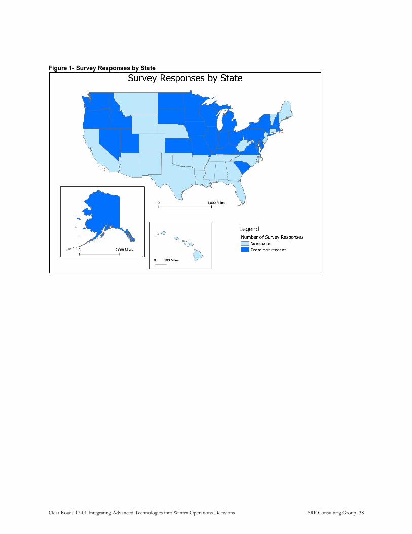
Figure 1- Survey Responses by State
Clear Roads 17-01 Integrating Advanced Technologies into Winter Operations Decisions SRF Consulting Group 38

Figure 2- Survey Responses by County
Questionnaire
The on-line questionnaire consisted of 28 questions with branching logic to minimize respondents being presented with irrelevant questions. Figure 3 shows the flowchart of the survey logic.
Clear Roads 17-01 Integrating Advanced Technologies into Winter Operations Decisions SRF Consulting Group 39

Figure 3- Flowchart of Survey Logic
Begin Survey Please provide your contact information
Will you be the maincontact for the project?
Please provide a main contact for the
projectNo
End Survey
Do you use any mobile weather or road surface
condition sensors on your winter maintenance vehicles?
Yes
Which sensor types do you
use?Yes
Do you use cameras to monitor
vehicle systems?
No
Do you have any other comments or questions regarding
this research?
No
What technology have
you used?Yes
Please check all the connected vehicle applications that
apply
Yes
Have you used or evaluated video analytics
to use video cameras to determine road surface or
weather conditions?
No
Is your agency planning for or evaluating 5G for
either mobile or roadside connectivity?
Yes
Do you use any crowdsourced weather
data sources to aid winter maintenance?
Does your agency utilize the
Maintenance Decision Support System (MDSS)?
Do you use any traffic data sources to aid
winter maintenance?
No
Has your agency begun planning for deployment
of an “Enhanced” or “Next Generation” MDSS?
Please describe how you use
this traffic data.Yes
Please describe these data analysis
tools.
Do you use any cloud computing
services?
Does your agency use “big data,” artificial
intelligence, or machine learning tools to store or analyze
data?
Which topics?
Please rate your organization’s
interest in learning more about the
applications of the following advanced
technologies in winter operations.
Do you use, or have you evaluated driver
assistance/collision avoidance technology on winter
maintenance vehicles?
Have you evaluated or used autonomous
technologies for winter maintenance
vehicles?
Have you evaluated or used connected vehicle technologies for winter
maintenance operations?
Please describe the video analytics
system
Do you use any of the following technologies
for providing connectivity to your
vehicles?
Do you use any of the following technologies
for providing connectivity to your
roadside infrastructure?
Please describe your efforts
towards NGMDSSYes
No
Please describe how you use this
weather data.Yes
No
Is your agency using data analysis tools other
than MDSS?Yes
Please describe which cloud
computing services you use and how
you use them.
Yes
Please describe which tools you
use and how you use them.
Yes
No
Does your agency use any data
visualization tools?
Please describe which tools you
use and how you use them.
Yes
Are any data visualizations available
to the public?
Please describe the publicly available visualizations and
provide a URL.
Yes
No
Are you conducting or planning
research projects for new technologies?
No
No
No
Yes
No
Clear Roads 17-01 Integrating Advanced Technologies into Winter Operations Decisions SRF Consulting Group 40

Results and Analysis
The survey revealed a number of trends where agencies have made significant investments in technology, as well as areas where there has been little to or no activity. These are summarized below.
Sensors: The majority of respondents used some mobile sensors on the vehicle, as shown Figure 4, which shows responses to question 4.
Figure 4- Sensors
Of those who responded that they used mobile sensors, 100% used pavement temperatures and air temperature sensors, with smaller numbers using humidity, surface condition, friction or dew point sensing.
Cameras: Roughly half of the respondents indicated they used cameras to monitor vehicle systems. Several of these were in a pilot or evaluation deployment, however.
Clear Roads 17-01 Integrating Advanced Technologies into Winter Operations Decisions SRF Consulting Group 41

Figure 5- Cameras and Vehicle Systems
Driver Assistance
Few agencies used or had an active evaluation of driver assistance/collision avoidance technologies.
Figure 6- Driver Assistance/Collision Avoidance Technology
Clear Roads 17-01 Integrating Advanced Technologies into Winter Operations Decisions SRF Consulting Group 42

Similarly, no agencies had used or evaluated self-driving systems.
Figure 7- Autonomous (Self-Driving) Technologies
Connected vehicle technologies have seen little active exploration by agenciesm with only two agencies having attempted pilot deployments. One respondent indicated skepticism that the technology was mature enough for full deployments at the time of the survey.
Figure 8- Connected Vehicle Technologies
Video Analytics
Although still relatively rare, the rapidly evolving capabilities of video analytics are being actively explored by some agencies. These are largely in two categories – analyzing video to determine roadway surface conditions and analyzing video to determine weather conditions. Roughly one third of respondents indicated that they were using analytics.
Clear Roads 17-01 Integrating Advanced Technologies into Winter Operations Decisions SRF Consulting Group 43

Figure 9- Video Analytics and Road Surface Conditions
Figure 10- Video Analytics and Weather Conditions
Communications
Respondents used a wide variety of communications methods to retrieve data from vehicles. Cellular communication was the most common, accounting for 70% of the total. Satellite data and DSRC accounted for 13% and 15% respectively. 11% used private data networks, with 8% having a dedicated wide area broadband network and 3% on private LTE (CBRS) networks.
At the roadside cellular communications was still the most common mode (55%) with satellite data and hardwired fiber optic connections accounting for 13% each. Other modes each were used by less than 10% of respondents
Clear Roads 17-01 Integrating Advanced Technologies into Winter Operations Decisions SRF Consulting Group 44
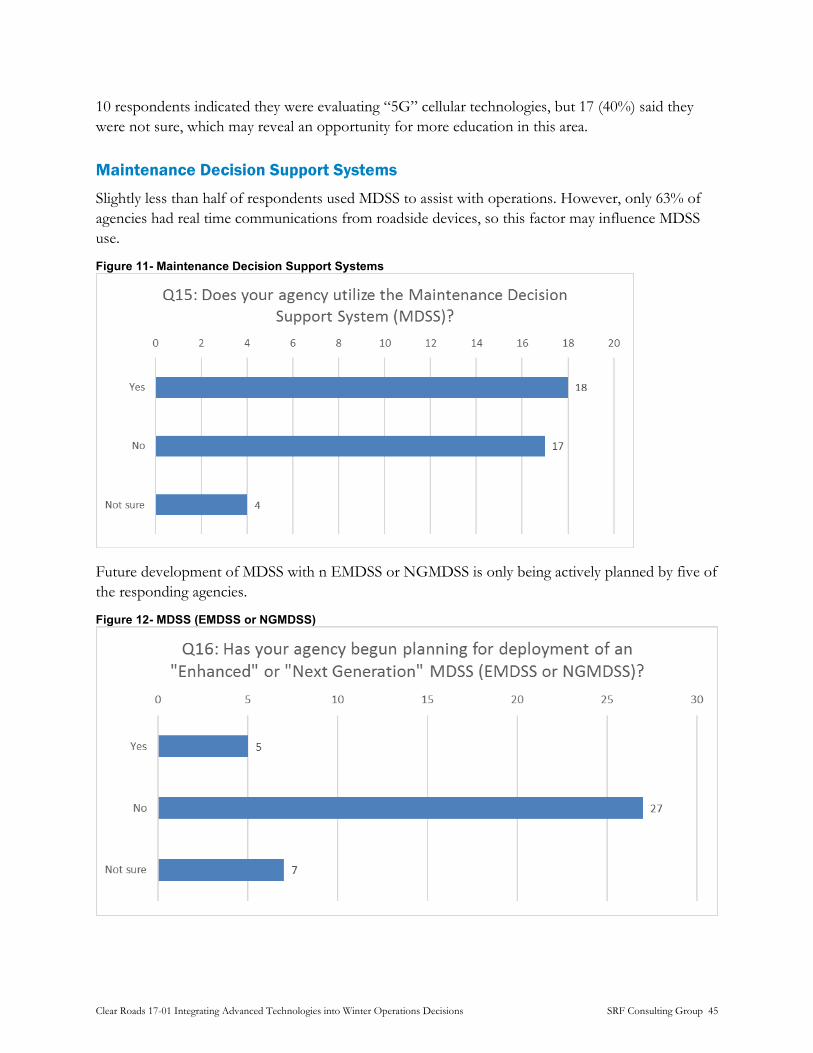
10 respondents indicated they were evaluating “5G” cellular technologies, but 17 (40%) said they were not sure, which may reveal an opportunity for more education in this area.
Maintenance Decision Support Systems
Slightly less than half of respondents used MDSS to assist with operations. However, only 63% of agencies had real time communications from roadside devices, so this factor may influence MDSS use.
Figure 11- Maintenance Decision Support Systems
Future development of MDSS with n EMDSS or NGMDSS is only being actively planned by five of the responding agencies.
Figure 12- MDSS (EMDSS or NGMDSS)
Clear Roads 17-01 Integrating Advanced Technologies into Winter Operations Decisions SRF Consulting Group 45

Crowdsourced Data
67% of respondents indicated that they used at least one “crowd” source for weather data, with Accuweather being the most common source named (26%). Interestingly, no respondents indicated that they used the Citizen Weather Observer Program.
Crowdsourced traffic data was less commonly used, with only 44% saying they used at least one source. Of the sources cited Google/Waze (33%) and INRIX (26%) were the most common.
Data Analytics
Few respondents used cloud computing services (apart from MDSS) as shown below.
Figure 13- Cloud Computing Services
Similar numbers used “big data” tools.
Figure 14- Artificial Intelligence
Clear Roads 17-01 Integrating Advanced Technologies into Winter Operations Decisions SRF Consulting Group 46
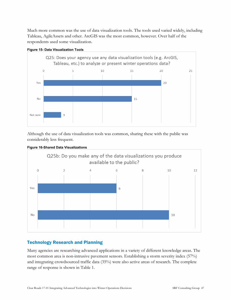
Much more common was the use of data visualization tools. The tools used varied widely, including Tableau, AgileAssets and other. ArcGIS was the most common, however. Over half of the respondents used some visualization.
Figure 15- Data Visualization Tools
Although the use of data visualization tools was common, sharing these with the public was considerably less frequent.
Figure 16-Shared Data Visualizations
Technology Research and Planning
Many agencies are researching advanced applications in a variety of different knowledge areas. The most common area is non-intrusive pavement sensors. Establishing a storm severity index (57%) and integrating crowdsourced traffic data (35%) were also active areas of research. The complete range of response is shown in Table 1.
Clear Roads 17-01 Integrating Advanced Technologies into Winter Operations Decisions SRF Consulting Group 47

Table 1- Technology Research and Planning
Q26: Are you conducting or planning research projects for new technologies to manage or improve winter maintenance operations?
Topic
Non-Invasive Pavement Sensors (NIPS)
Maintenance Decision
Support System (MDSS)
Enhanced/Next Generation
Maintenance Decision Support
System (EMDSS/NGMDSS)
Weather/ Storm
Severity Index
Camera Analytics
Performance Index
Count 15 9 4 13 9 10
Percentage 65% 39% 17% 57% 39% 43%
Topic
Crowdsourced Weather
Data
Machine Learning/
Artificial Intelligence
(AI)
Traffic Data Sources (Google/Waze,
INRIX, HERE, etc.) Big Data Cloud
Computing Data
Visualization
Count 6 4 8 3 2 5
Percentage 26% 17% 35% 13% 9% 22%
The survey also attempted to gauge the level of interest the various technology areas. Figure 17 provides a graphical visualization of how respondents ranked interest. Performance and Storm Severity showed very strong interest, where Cloud Computing and Big Data tools had the most responses showing least interest.
Clear Roads 17-01 Integrating Advanced Technologies into Winter Operations Decisions SRF Consulting Group 48
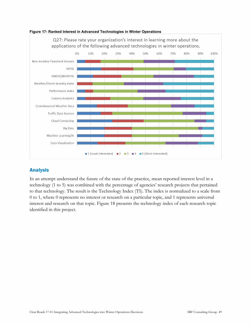
Figure 17- Ranked Interest in Advanced Technologies in Winter Operations
Analysis
In an attempt understand the future of the state of the practice, mean reported interest level in a technology (1 to 5) was combined with the percentage of agencies’ research projects that pertained to that technology. The result is the Technology Index (TI). The index is normalized to a scale from 0 to 1, where 0 represents no interest or research on a particular topic, and 1 represents universal interest and research on that topic. Figure 18 presents the technology index of each research topic identified in this project.
Clear Roads 17-01 Integrating Advanced Technologies into Winter Operations Decisions SRF Consulting Group 49

Figure 18- Technology Index
Gathering data and creating mechanisms for calculating objective indices of storm severity and performance show a clear lead over more technology-centric topics. However, it should be noted that these results may be biased based on the familiarity of the respondent with a given topic. Nevertheless, a picture of where emphasis will be placed by agencies can be gleaned from the Technology Index.
Conclusions
The results of this survey show some common trends across agencies, as listed below:
• Emerging technologies such as AV, CV, 5G, machine learning, etc. are not actively pursued by agencies, likely due to the need for existing infrastructure to collect the information needed to utilize these technologies. However, while not common, agencies are researching technologies, such as route-based forecasting, automated spreading, and the use of big data services.
• Cellular communication over 3G, 4G, or LTE networks was by far the most common means of communication to field equipment, both for vehicles and stationary roadside equipment. This means that as 3G and non-LTE 4G services are phased out by carriers, the pursuit of 5G technology will be crucial to the ongoing operations of many agency’s advanced winter maintenance technologies.
• Agencies that use MDSS frequently supplement those services with external weather data, traffic data, and analysis tools. Agencies that do not use MDSS use these sources as the primary sources of information. Very few agencies do not use any data at all to support their maintenance operations.
Clear Roads 17-01 Integrating Advanced Technologies into Winter Operations Decisions SRF Consulting Group 50

Ultimately, while adoption of many advanced technologies is tentative at this time, several agencies have progressive research projects.
Clear Roads 17-01 Integrating Advanced Technologies into Winter Operations Decisions SRF Consulting Group 51
Follow-Up Interviews
Survey respondents provided several interesting responses indicating the implementation of unique pilot projects and other novel technology use cases. Five agencies with particularly intriguing responses were selected from the survey respondents for follow-up interviews to learn more about these deployments. These were (along with the reason for selection):
• Kentucky Transportation Cabinet (use of big data platforms) • Idaho Transportation Department (mobile RWIS pilot project) • Iowa Department of Transportation (future road condition predictions) • New York State Department of Transportation (use of Next Generation MDSS) • Vegvesen (Norwegian Public Roads Administration; use of Vaisala Road AI equipment)
Interview Summaries
Kentucky Transportation Cabinet
Interview Subjects • Randi Feltner, Transportation Engineer Specialist, KYTC • Jeremy Gould, GIS Consultant, KYTC
Reasons for Selection • Use of big data platforms (including Hadoop, Kibana Elastic, and Kafka)
Deployment Summary KYTC has developed a suite of big data platforms in-house in order to inform their winter maintenance decisions. These platforms are used to process, store, and enrich data with the ultimate goal of producing dashboard visualizations to improve responses to winter events and perform post-event analysis. Currently, these platforms are used exclusively for winter maintenance applications; however, the potential exists for applying these platforms to different areas of KYTC’s operations. KYTC looks to expand its system in the future with additional use cases as needed.
Questions and Responses
Big Data Applications
Q: Why did you choose to build your own data platform rather than using another available solution (MDSS, or other)?
Clear Roads 17-01 Integrating Advanced Technologies into Winter Operations Decisions SRF Consulting Group 52

A: Given KYTC’s specific problems they wanted to address, including snow and ice maintenance, it was considered more efficient for KYTC to develop its own data platforms. This allowed KYTC to integrate multiple data sources, including the specific data sources beyond MDSS they had access to.
Q: Did you develop your solution in-house (KYTC or other Kentucky staff)?
A: All applications were developed in-house by KYTC. These platforms are used only by KYTC. Other agencies within Kentucky are not using these platforms.
Q: Are you satisfied with the performance and functionality of your solutions?
A: Yes – the speed of data collection and dashboards has been very good. Outside of the main office in Frankfort, speeds can slow down, but this is due to bandwidth issues unrelated to software performance.
Q: Do you host your solutions in a Kentucky data center, or at a provider, such as AWS or Azure?
A: Applications and data are hosted in a centralized location in a KYTC facility in Frankfort.
Q: How is data being collected for your big data platforms?
A: Weather data is collected from RWIS stations owned by KYTC, as well as additional RWIS owned by universities and free radar services from the National Weather Service (NWS). Traffic data is collected from ITS equipment and cameras as well. Data is stored for up to one year.
Q: What is each of your big data platforms used for?
A: Programs written in the Scala language are used to ingest data to Kafka, a distributed data storage system that allows multiple records to be written to simultaneously. Kafka processes the data and provides the data to Hadoop utilities for management. Data is also sent to an Apache Spark cluster computing system, which enriches the data with information such as the county and milepost and writes the data back to Kafka. Data is then pushed to Elastic Search which indexes the data. Data is then visualized using Kibana dashboards for use by KYTC staff. Data is also viewed using ArcGIS Online which displays real time data.
Q: How does the cost of your solution compare to a commercially available package?
A: Addressing KYTC’s specific use-cases was more important than cost considerations, which made the availability of freely modifiable, open-source software more attractive than commercial solutions.
Q: Do you make the code developed available to other agencies?
A: Other agencies have asked for KYTC’s code and KYTC has been willing to provide it. However, no one has implemented KYTC’s code or developed it further to KYTC’s knowledge.
Q: Who is given access to the data?
Clear Roads 17-01 Integrating Advanced Technologies into Winter Operations Decisions SRF Consulting Group 53
A: Anyone at KYTC is able to see the dashboards, though analysis is typically performed exclusively by the ITS and snow and ice maintenance teams.
Data Visualizations and Other Data Usage
Q: Who has access to visualization and analysis tools?
A: Data visualizations are shared with other state agencies such as emergency services and GoKY (Kentucky’s traveler information website). GIS maps are available to the public through GoKY.
Q: What data is being collected?
A: All maintenance vehicles have GPS installed, and about two-thirds of maintenance vehicles are equipped with an AVL system. The GPS provides vehicle position, speed, and heading, while the AVL system also collects air and pavement temperatures, plow status (ie, whether the plow is up or down), and spreader material usage information.
Q: How is this data used to inform your winter maintenance decisions?
A: Dashboards created include snow- and ice-related information, such as air and pavement temperatures, traffic data, and storm severity information. This data is used for maintenance action planning as well as post-event evaluation.
Q: How is traffic data from HERE and Waze used for post-event evaluation?
A: Traffic data is used to make determine and verify when traffic incidents have occurred before pushing the information to the public via GoKY. HERE is a paid service, while KYTC has a two-way data sharing agreement with Waze allowing them to access their traffic data at no cost.
Other Comments KYTC uses Iteris MDSS; however, MDSS is seen as only a complement to KYTC’s big data applications at this time. The MDSS system only covers specific, pre-defined routes and is therefore cannot provide data for the majority of KYTC’s winter maintenance operations. The KYCT’s in-house solutions allow them to address their entire road network.
Future plans for KYTC’s big data platform include moving the system to a “cloud” remote hosting facility, developing a storm severity index, and adding additional use cases as desired. In addition, KYTC is interested in the possibility of re-timing signals automatically based on real-time data such as vehicle speed. KYTC’s AVL provider is also moving to an open-source platform which may allow for additional opportunities for system expansion.
Clear Roads 17-01 Integrating Advanced Technologies into Winter Operations Decisions SRF Consulting Group 54

Idaho Transportation Department
Interview Subjects • Steve Spoor, Maintenance Services Manager, ITD
• Max Thieme, Program Specialist, ITD
Reasons for Selection • Pilot project with Vaisala Mobile RWIS
• Use of cameras pointed towards wing plow for operator use
Deployment Summary Idaho Transportation Department (ITD) participated in a pilot deployment of Vaisala’s Mobile RWIS system to supplement their existing stationary RWIS stations by allowing drivers to more effectively respond to real-time weather information. In addition, ITD has camera systems deployed on several maintenance vehicles to monitor wing plow operations with features such as integrating floodlights to assist with camera operation in low-light conditions.
Questions and Responses
Vaisala Mobile RWIS
Q: How was Vaisala selected for a pilot project?
A: Vaisala is the manufacturer of ITD’s stationary RWIS stations, with which ITD is very satisfied. Vaisala reached out to Idaho to inquire about ITD’s interest in a pilot project with its NV30 Mobile RWIS. Idaho agreed and has deployed mobile systems in Districts 5 (Pocatello area) and 6 (Idaho Falls area). The Vaisala mobile RWIS system is compatible with their existing RWIS system’s data management.
Q: How many vehicles are in the pilot?
A: Three vehicles, with two in District 6 and one in District 5.
Q: What data is the mobile RWIS collecting?
A: The mobile RWIS is collecting snow/ice layer thicknesses and pavement temperatures. This data is used to generate a thermal map of the road to identify low-temperature spots. Stationary RWIS are used to collect air temperature and other data.
Q: How is this data transmitted and stored?
Data is transmitted via cellular modem from the vehicles and is stored on Vaisala servers.
Q: How does this data inform your winter maintenance decisions?
Clear Roads 17-01 Integrating Advanced Technologies into Winter Operations Decisions SRF Consulting Group 55

A: Operators have praised the system for the ability to see information in real time on a display in the cab and decide how much material to use in spreading operations on the fly. The system has helped operators be more efficient.
Q: How do you rate your overall satisfaction with the pilot project?
A: The pilot has concluded with excellent results. ITD wants to expand its deployment of Vaisala mobile RWIS but is waiting for Vaisala to develop the second generation of its mobile RWIS product before doing so. The second generation of devices will have shrunk in size and incorporate anti-icing technology.
Q: Who is given access to the data?
A: Operators and maintenance supervisors (foremen) have access at the time of the survey. Because the data is stored on Vaisala’s servers there are intellectual property issues that prevent providing data to the public. ITD is evaluating possibilities of uploading this data to 511 but has not made a decision yet.
Wing Plow Camera System
Q: What was the objective of installing the wing plow camera and have the results been what was expected?
A: Cameras have been generally helpful to operators but have experienced issues with icing. Floodlights have also been installed to improve low-light visibility. In addition, operators have reported that by the time the camera provides visual confirmation of an issue with the wing plow such as an impending collision, it is typically too late for the driver to respond.
Q: What model cameras do you use for wing plow monitoring?
A: Several different camera models are used. The cameras do not have a wash system integrated, and the interviewees didn’t know if the cameras are equipped with a heated lens.
Q: How do the drivers view the images from the camera in-cab?
A: A 10-inch tablet is installed that serves the dual purpose of displaying camera images and operating the spreader. The tablet is manufactured by Certified Cirus.
Q: Are the videos stored or transmitted in any way?
A: No, videos are only for the operator’s use in real time and are not recorded or stored.
Q: What are the most common issues encountered with monitoring cameras?
A: Icing and corrosion are common issues. Issues have also been experienced with image quality of the camera not providing a useful view for drivers. Floodlights have been incorporated into camera systems to help with this.
Q: How do you rate your overall satisfaction with the system?
Clear Roads 17-01 Integrating Advanced Technologies into Winter Operations Decisions SRF Consulting Group 56

A: Overall satisfaction was qualified and described as “satisfied enough” – however, ITD is looking to improve upon their system if possible.
Other Comments Vaisala assisted with installation of the mobile RWIS system during the pilot, and operators reported having no issues with the installation.
Iowa Department of Transportation
Interview Subject • Tina Greenfield Huitt, RWIS Coordinator, Iowa DOT
Reasons for Selection • SAS Institute is testing their system for winter road condition predictions
• Real-time maintenance cost data visualizations
Deployment Summary Iowa DOT is participating in a pilot project with the software developer SAS Institute (SAS) to use the DOT’s collected weather and traffic data to produce future road condition predictions that can be used to provide forecast conditions on the state’s 511 system. Iowa DOT also produces data visualizations showing the real-time cost of winter maintenance efforts that are provided to the public online.
Questions and Responses
Partnership with SAS
Q: What is the relationship between Iowa DOT and SAS for your testing?
A: IowaDOT has a statewide contract with SAS for a 2-year pilot project that is approximately halfway complete at the time of the survey. SAS is developing data visualizations and algorithms to generate future (1-hour, 3-hour, and 6-hour) road condition predictions with the intent of possibly providing to 511 in the future. SAS also provides Iowa DOT with a visual analytics system. The final intended use case is to provide Iowa DOT with an API.
Q: What data is SAS accessing and using?
A: Traffic, weather data, and plow AVL data.
Q: What devices and sensors are used to obtain this data?
Clear Roads 17-01 Integrating Advanced Technologies into Winter Operations Decisions SRF Consulting Group 57

A: Traffic data is obtained from INRIX and Wavetronix detectors. Weather data is obtained from RWIS and airport weather stations, as well as from NWS. AVL data is obtained from the vehicles directly.
Q: How is this data being transmitted and stored?
A: Iowa DOT obtains the data directly from their vehicles, detectors, and RWIS stations through cellular communication, and then provides the data to SAS who stores it on their servers.
Q: Has SAS had any success updating 511 reports with their predictions?
A: Success to date has been described as “OK” – there have been data formatting issues including providing dates and times of data in proper formats. There were also issues in the beginning stages as the machine learning algorithms had not had access to enough data to be properly sophisticated. There are also issues when information such as RWIS data is unavailable – in these cases, the system is unable to make a prediction using other data.
Q: Who is given access to the data?
A: A small research group at Iowa DOT, including maintenance supervisors, RWIS managers, IT staff, and researchers at Iowa State University. Data is not made public over 511.
Data Visualizations
Q: What software is used to produce Iowa DOT’s real time maintenance cost visualization?
A: The data is managed by an ESRI GIS software, and the visualizations use data from the plow AVL system. Creation of graphics and other displays is currently done manually.
Q: How does Iowa DOT use the Pikalert Vehicle Data Translator system to inform its winter maintenance decisions?
A: Pikalert provides Iowa DOT with help in operational decision making and is also another avenue for potentially providing road conditions to 511. It is also used by other departments at Iowa DOT, such as communications staff.
Q: Describe Iowa DOT’s efforts to integrate Pikalert with traffic operations, AVL data, and imagery.
A: Pikalert is fully installed and integrating as of October 2019 and is operating in test mode. Data is not provided to the public at this time.
New York State DOT
Interview Subject • Joe Thompson, Snow and Ice Program Manager, NYSDOT
Clear Roads 17-01 Integrating Advanced Technologies into Winter Operations Decisions SRF Consulting Group 58

Reasons for Selection • Reported pursuing Next Generation Maintenance Decision Support System (NGMDSS)
efforts
• “Limited” use of vehicle monitoring cameras
Deployment Summary NYSDOT reported working towards a NGMDSS system called “Every Day Counts Weather Responsive Management System (EDC-WRMS) and utilization of DSRC communication.
Questions and Responses
NGMDSS Efforts
Q: What pavement sensors do you use and what data do you collect from them?
A: Pavement and air temperature sensors, along with High Sierra surface water sensors for use on spreaders.
Q: How is this data transmitted and stored?
A: Data is transmitted over cellular and stored on USGS web servers.
Q: What is your EDC-WRMS NGMDSS system?
A: EDC-WRMS stands for “Every Day Counts Weather Responsive Management System” and is an FHWA NGMDSS program.
Q: What crowd sourced data do you use to support your EDC-WRMS system?
A: Waze traffic data, 511 information, and direct citizen reporting.
Q: What is being transmitted over DSRC?
A: Air and pavement temperatures, as well as loss of vehicle traction events.
Q: Have you had any common issues with your DSRC network?
A: DSRC is currently not being used for transmission of data outside of testing due to issues getting on-board units to function in low temperature conditions. DSRC is, however, used for communication between vehicles and RWIS stations close to the highway.
Q: How does your NGMDSS system differ from regular MDSS systems?
A: Traditional MDSS systems used by the state have experienced accuracy and reliability issues, and required field verification which used up too much of maintenance staff’s time. While the NGMDSS system still requires field verification, it has been more effective and reliable and is more robust in use for supporting post-storm analytics.
Clear Roads 17-01 Integrating Advanced Technologies into Winter Operations Decisions SRF Consulting Group 59
Q: Who is given access to the data?
A: Only vehicle operators – nothing is provided to the public at this time.
Other Topics
Q: What is your RTK collision avoidance system?
A: This is a system being developed by the University of Minnesota that uses GPS and sonar to map and detect vehicle locations to warn drivers of potential collisions in low light conditions. The system is in its infancy and purely academic in nature, and is not yet installed on any trucks. The technology at this time is very expensive, but is expected to become more affordable in the future.
Q: You mentioned a “limited” system of vehicle monitoring cameras – please describe this system.
A: A pilot program using dash cameras on plows was implemented. It was not liked by plow operators and was not effective and has since been discontinued.
Other Comments
NYSDOT is working on expanding their research into AI and machine learning through the University of Albany, and there is the possibility for a future partnership with IBM on these matters.
Norwegian Public Roads Administration
Interview Subject • Kai Rune Lysbakken, Senior Principal Engineer, Vegvesen (Norwegian Public Roads
Administration)
Reasons for Selection • Use Vaisala Road AI equipment
• Reported AV applications by Norwegian airport operator Avinor
• Reported use of automatic spreading
Deployment Summary Vegvesen (Norwegian Public Roads Administration) conducted a pilot project with Vaisala’s Road AI product, which uses machine learning and AI to make better recommendations for winter maintenance. In addition, they reported a Norwegian public airport operator, Avinor, participating in a deployment of automated runway sweepers. Further, Vegvesen has expressed interest in integrating 5G communication into their winter maintenance vehicles as 5G becomes more widespread in Norway.
Clear Roads 17-01 Integrating Advanced Technologies into Winter Operations Decisions SRF Consulting Group 60

Questions and Responses
Vaisala Road AI
Q: Describe the Vaisala Road AI system.
A: Norway is participating in a pilot project with Vaisala using its Road AI system, which uses cameras mounted on winter maintenance vehicles to analyze road surface conditions and the quality of pavement markings. It can use machine learning to make recommendations for road maintenance, however, Vegvesen has not explored this yet. The system has only been tested over one winter season to date.
Q: What data do you collect using Road AI?
A: Road AI collects data on pavement conditions, such as the location and severity of pavement cracking. However, Vegvesen uses the cameras mostly for qualitative pavement analysis at this point.
Q: How is this data transmitted and stored?
A: Data is transmitted over the cellular network and stored on Vaisala’s servers.
Q: How is this data used to advise your winter maintenance operations?
A: Currently, the data is not analyzed for pavement marking quality or recommendations. However, qualitative pavement analysis is conducted through the images captured by Road AI cameras and Vegvesen uses this to analyze the relationship between road surface conditions and traffic accidents.
Q: Is the data used for any other applications?
A: Not at this time – Vegvesen is looking to expand its use of the Road AI system; however, a potential use case list still needs to be developed.
Q: Do you have issues with communicating to your vehicles? If so, what are they?
A: No issues have been experienced. Communication to vehicles is achieved through Vaisala cellular devices.
Q: What are the most common device failures in your communication network?
A: No issues have occurred to date; however, the system has only been deployed for a short time.
Q: Who is given access to the data?
A: Only the project group at Vegvesen and some plow contractors, as Norway has no state-operated snowplows. No data is provided to the public at this time.
Clear Roads 17-01 Integrating Advanced Technologies into Winter Operations Decisions SRF Consulting Group 61

Avinor AV Applications
Q: Please describe your knowledge of Avinor’s automated runway sweeper project.
A: Avinor is a state-owned Norwegian airport operator. The system was first tested on a small runway at a rural airport with low air traffic and is now being tested at the airport in Oslo. However, while Kai is unaware of the details of the project, the system is a long way from full implementation at multiple airports.
Q: Can you provide a contact from Avinor?
A: Kai provided a presentation on Avinor’s automated runway sweeper project, which is attached to the Follow-Up Interview Technical Memo submitted for Task 5 of this project.
Automatic Spreading Q: How does your automatic spreader system function?
A: The automatic spreader operates based on GPS-derived location rather than operator input and is common technology. This does not refer to any CAV applications.
Q: Is data obtained from Road AI used in your automatic spreading?
A: No, see the response to the previous question.
Q: Are there current plans to implement 5G technology for winter maintenance once it is deployed?
A: Kai was not sure and provided a contact for his colleague who is working on the integration of 5G infrastructure in Norway.
Other Comments Vegvesen is highly satisfied with the quality of the Road AI system, as it allows them to “have eyes on the road.”
Summary of Findings
Advanced technology applications for winter maintenance remain somewhat uncommon. Often, these are deployed only in a pilot and not to their full potential, such as NGMDSS and machine learning applications. However, initial successes have been documented through the interviews. The success of these projects should lead to more widespread acceptance of use of these technologies.
Key points learned from the interviews were:
• KYTC’s robust self-developed big data platforms assist its winter maintenance team by collecting data from various sources and displaying it in a manner that is effective for preparation for winter events as well as post-storm analysis. KYTC is looking to expand its system to address other winter maintenance use cases and potentially serve other departments within KYTC.
Clear Roads 17-01 Integrating Advanced Technologies into Winter Operations Decisions SRF Consulting Group 62

• ITD’s pilot project with Vaisala’s mobile RWIS system was successful and ITD is looking to move forward with greater implementation of the system when Vaisala produces its second generation of devices. The system has helped with efficiency of spreading operations by providing drivers with real-time information.
• Iowa DOT’s pilot project with SAS for future road conditions has had mixed results – while the system has encountered issues with data formatting and gaps in data causing the system to be unable to produce predictions. Iowa DOT is exploring several options for providing data to 511 services, including this pilot and its Pikalert system.
• NYSDOT’s pursuit of a next-generation MDSS system has been very limited to date. Such technology may not yet be at a state when it can be effectively integrated into winter maintenance operations.
• Vegvesen’s pilot with the machine learning-based Vaisala Road AI product has been successful in analyzing pavement conditions during winter and is looking to expand its use of the system into greater applications to winter maintenance operations.
Clear Roads 17-01 Integrating Advanced Technologies into Winter Operations Decisions SRF Consulting Group 63
Data Analytics (Big Data) Tool Summary
Introduction
Data analytics tools can help maximize snow removal efficiency and minimize costs by enabling analysis of large volumes of data that would otherwise not be practical to use. Some of the benefits of using data analytics in for snow removal operation management include:
Real time decision making: a. Enhanced real-time routing optimization
b. Cost-benefit decision making analysis in real-time for surface regain times and material application
c. Improved deployment based on snowfall and traffic conditions
d. Identifying the root causes of failures of snow removal machinery in real time and historically
Scalability and prediction opportunities: e. Machine learning for improved safety in routing and maintenance timing
f. Weather and surface condition impact prediction
g. Equipment deterioration rate and service life estimation
The tools for data storage, data analytic and visualization are complex, with many options for each facet of the system. This section introduces data analysis processes and components in the context of winter operation maintenance. The trade-offs between implementation methods, database management processes, and hosting options are presented. Examples of data analysis application for winter operation decision-making are also discussed.
Components and Tools While different applications may often require different stack options, there remain major commonalities in any processing pipeline (Helu et al. 2020). There are four major components in any data analysis project, and a variety of tools that can provide each component (Lehmann et al. 2017). The four components are:
• Data Wrangling - Data wrangling (also called data munging) is the process of transforming, and mapping data from one "raw" data form into another format more appropriate for downstream purposes (Contreras-Ochando et al. 2017)
Clear Roads 17-01 Integrating Advanced Technologies into Winter Operations Decisions SRF Consulting Group 64

• Data Warehousing - A data warehouse is a system that pulls together data from many different sources within an organization for reporting and analysis (Chaudhuri and Dayal 1997). A unified database (also known as an enterprise data warehouse or data lake) can hold all the winter operation information of an agency and makes it accessible across the organization.
• Data Analysis - This process is where discovery and insights to the data begins (and some of this is visualization) but goes deeper than visual inspection and reporting. Data analytics can be categorized into three classes:
1. Descriptive analytics describes what has happened over a given period (e.g., average fuel usage of winter operation vehicles)
2. Diagnostic analytics focuses more on why something happened. This involves more diverse data inputs and hypothesis testing (e.g., finding vehicle with high fuel consumption rate – outlier analysis)
3. Predictive analytics moves us (via artificial intelligence) to what is likely going to happen in the future (e.g., predicting future fuel consumption rates based on historical data)
• Data Visualization- These tools aggregate and summarize data, along with creating visualizations that can quickly show results of “what-if” scenarios. Visualization predominantly occurs after the deeper analysis is conducted (in analytics) and represents more of the final end-user reporting.
Clear Roads 17-01 Integrating Advanced Technologies into Winter Operations Decisions SRF Consulting Group 65

The following figure shows a generic analytics data pipeline that can be used for winter operations decision making.
Figure 19- Visual Representation of a Generic Stack
A wide variety of tools can be used to provide each of these four components. These tools were assessed based on their complexity to deploy and suitability to meet the needs of winter operation managers.
Data Wrangling: There is a wide range of data wrangling tools available, some of which are user-friendly and can even be used by the average person with minimal training. The latest data preparation tools offer ease of use, quick and efficient results and analysis, unlike the programs available in the past. Figure 20 introduces some of the more popular tools.
Clear Roads 17-01 Integrating Advanced Technologies into Winter Operations Decisions SRF Consulting Group 66
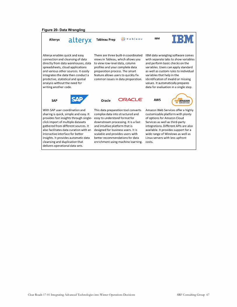
Figure 20- Data Wrangling
Clear Roads 17-01 Integrating Advanced Technologies into Winter Operations Decisions SRF Consulting Group 67

Data Warehousing: Today, there are cloud-based data warehousing tools that are fast, highly scalable, and available on a pay-per-use basis. Some are shown as examples in Figure 21.
Figure 21- Data Warehousing
Clear Roads 17-01 Integrating Advanced Technologies into Winter Operations Decisions SRF Consulting Group 68

Data Visualization: Four examples of these platforms are shown in Figure 4. Note that there is a wide disparity in sophistication and consistency. Machine Learning for example, is only now starting to appear in these tools. Several other visualization platforms are listed in Figure 5.
Figure 22- Data Visualization
Clear Roads 17-01 Integrating Advanced Technologies into Winter Operations Decisions SRF Consulting Group 69

Figure 23- Example Data Visualization, Analytics and Reporting Tools
Gartner Analytics Market Report (Graphic: Gartner)
Choosing Tools and Deployment Methods
There are many tools available for each component of data analytic stack. When choosing the parts of a stack, it is important to understand implementation trade-offs, database and file systems, and hosting options.
Implementation Trade-offs
There are two approaches to implementing a data analytics stack: in-house (using agency staff and resources) and outsourced (using third party experts and possibly data center resources). An in-house winter operations stack solution makes modifications to the application more convenient and faster. On the other hand, outside vendors may not have prior experience with winter operation applications, leading to unsatisfactory solutions. In Strengths, Weaknesses, Opportunities and Threats (SWOT)
Clear Roads 17-01 Integrating Advanced Technologies into Winter Operations Decisions SRF Consulting Group 70

Analysis matrix is shown to assist agencies’ decision support process and to weigh the benefits vs challenges of building an in-house winter operation analytics platform.
Figure 24- SWOT Analysis: In-House
Clear Roads 17-01 Integrating Advanced Technologies into Winter Operations Decisions SRF Consulting Group 71

Figure 25- SWOT Analysis: Third Party Solution
Hosting Options
Hosting is where the data and software tools physically reside. In general, there are two types of computing hosting options, on-premises and “cloud”.
On-premises software is installed and runs on computers on the premises of the agency using the software rather than at a remote cloud facility. There are typically three models of cloud service for comparison: Software as a Service (SaaS), Platform as a Service (PaaS), and Infrastructure as a Service (IaaS). Each of these has its own benefits and limitations. All of these may contain a data warehouse (data lake) but vary by deployment model. The figure below explains the differences between these installations and configurations.
Clear Roads 17-01 Integrating Advanced Technologies into Winter Operations Decisions SRF Consulting Group 72

Figure 26- On- Premises vs. Cloud Computing
Total Cost of Ownership
While cloud approaches may be attractive in that they allow an agency to focus on its core functions, this must be weighed against the overall total cost of solution ownership (TCO). In addition to software, maintenance and access costs, there are many other elements. such as additional training costs, long-term support, and implementation. Many of these may emerge as “hidden” costs.
Cloud processing time is an example of a hidden TCO cost. Depending on the process and number of CPU instances required, this can quickly exceed the base monthly charge for hosting. Fees for loading and unloading data from the system can also be substantial. Figure 10 summarizes the major advantages both installation methods. Agencies should also consider:
• IT Staffing: Specialzed IT skills are necessary, especially when applications are tailored to meet an organization’s unique requirements.
• Hardware, Software Licensing, and Support: Significant upfront hardware and software costs (capital expenditures or “cap-ex”) make changing approaches very expensive.
• Storage: As the needs for computation grows, new space for new piece of hardware should be rapidly accommodated.
Clear Roads 17-01 Integrating Advanced Technologies into Winter Operations Decisions SRF Consulting Group 73

Figure 27- Cloud vs. On-Premise: Advantages and Drawbacks
Trade-offs of Advanced Database and File Systems
Managing datasets is a key to extracting usable information. However, there are different technologies for database management and understanding the differences is important. In this subsection, two types of data base management systems (i.e. relational and distributed) will be briefly introduced and compared. Also, a summary of comparison between these two methods can be found in Figure 11.
Clear Roads 17-01 Integrating Advanced Technologies into Winter Operations Decisions SRF Consulting Group 74
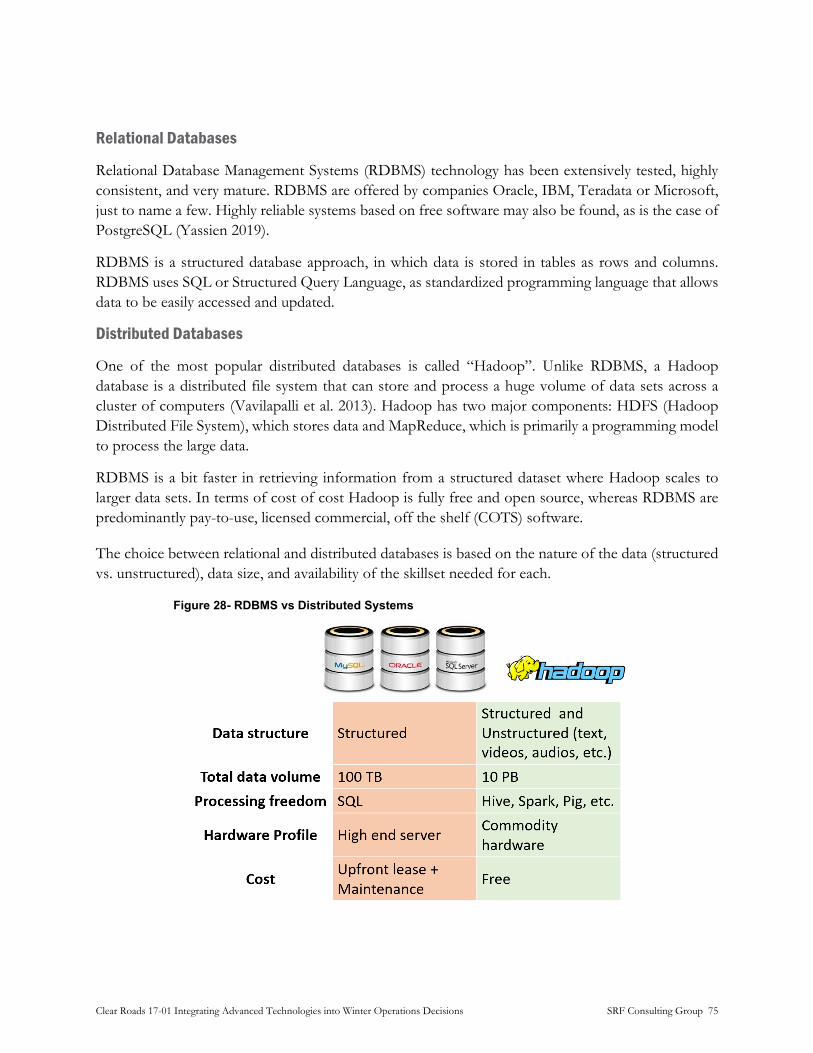
Relational Databases
Relational Database Management Systems (RDBMS) technology has been extensively tested, highly consistent, and very mature. RDBMS are offered by companies Oracle, IBM, Teradata or Microsoft, just to name a few. Highly reliable systems based on free software may also be found, as is the case of PostgreSQL (Yassien 2019).
RDBMS is a structured database approach, in which data is stored in tables as rows and columns. RDBMS uses SQL or Structured Query Language, as standardized programming language that allows data to be easily accessed and updated.
Distributed Databases
One of the most popular distributed databases is called “Hadoop”. Unlike RDBMS, a Hadoop database is a distributed file system that can store and process a huge volume of data sets across a cluster of computers (Vavilapalli et al. 2013). Hadoop has two major components: HDFS (Hadoop Distributed File System), which stores data and MapReduce, which is primarily a programming model to process the large data.
RDBMS is a bit faster in retrieving information from a structured dataset where Hadoop scales to larger data sets. In terms of cost of cost Hadoop is fully free and open source, whereas RDBMS are predominantly pay-to-use, licensed commercial, off the shelf (COTS) software.
The choice between relational and distributed databases is based on the nature of the data (structured vs. unstructured), data size, and availability of the skillset needed for each.
Figure 28- RDBMS vs Distributed Systems
Clear Roads 17-01 Integrating Advanced Technologies into Winter Operations Decisions SRF Consulting Group 75

Data Analytics in Winter Operations: Examples
Analytics allows agencies to go deeper than visualization and identify or discover the trends and patterns inherent in the data. In this section, three examples of data analytics applications and methods in decision-making for winter operations are presented.
Artificial-Intelligence-Based Optimization of the Management of Snow Removal Assets and Resources
A study conducted in 2002 at University of Northern Iowa which used Geographic information systems (GIS) and artificial intelligence (AI) techniques to develop an intelligent snow removal asset management system (SRAMS). SRAMS contains the logical rules and expertise of the Iowa DOT’s snow removal experts in Black Hawk County, and a geographic information system to access and manage road data. The system efficiently generated prioritized snowplowing routes, optimized plowing assets , and to tracked materials (e.g., salt and sand) (Salim and Timmerman 2002). The analytics approach used in this study is shown in Figure 13.
Figure 29- Analysis Approach
The Analysis Approach for Optimization of the Management of Snow Removal Assets and Resources
(Graphic: SRF Consulting)
Winter Operations Decision Support Tools for the Iowa DOT Maintenance Bureau
The Institute for Transportation at Iowa State University explored new methods to support real-time, accurate decision-making during winter operations using the massive stream of data coming from
Clear Roads 17-01 Integrating Advanced Technologies into Winter Operations Decisions SRF Consulting Group 76

snowplow fleet. The plows continuously transmit location, plow status, and material spreader status. This research project created visual and tabular summaries of one day of winter operations data to provide practical information for both administrative and district maintenance staff. Future efforts can consider integrating these summaries and similar tools into daily operations (Hawkins et al. 2020).
Effects of Weather Conditions and Snow Removal Operations on Travel Speed in an Urban Area
In Sapporo, Japan, roads are more prone to traffic congestion in winter than in different seasons due to reductions in travel speeds and available lanes. A study was conducted at Hokkaido University (Japan) in year 2017 to investigate the effects of weather conditions and snow removal operations on travel speed to determine the causes of winter traffic congestion. Machine learning models were used to predict impact of snow removal operation and weather conditions on the traffic flow. Figure 15 presents the overview of the analysis described here. The study found that southbound traffic differs from northbound traffic in reaction to snow removal operations. Road-widening operations and snowfall had more effect on southbound traffic than on northbound traffic, and fresh snowfall had more impact on northbound traffic than on southbound traffic.
The most accurate machine learning model was selected for future front-end development. The second phase of this project (which started in 2018) is developing a visual decision-making platform that helps manage road networks most cost-effectively.
Figure 30- Methodology
Methodology used to investigate the effect of snow removal operations on travel speed
Recommendations for Best Practices
Data analytics, machine learning, and deep learning (AI) are hot topics that are becoming ubiquitous and yet mostly invisible. Because of this rapid ascent therein lies potential minefields.
There is no one size fits all solution, and some offerings may not be a good fit for winter operations analytics. These technologies are, fundamentally, automation technologies. In some cases, this will lead to job displacement resulting from improved efficiency. Conversely, over-reliance on machine processes may result in poor decisions better served by human cognition.
Clear Roads 17-01 Integrating Advanced Technologies into Winter Operations Decisions SRF Consulting Group 77

Agencies should embrace technology with practicality and realism. Humans are the ultimate end-user, and technology is not embraced by these end-users, investment could fail. Therefore, best practice guidelines are recommended to maximize the benefits of winter operations technology investments. Examples include (but are not limited to):
• Create internal agency culture that is comfortable interacting with data visualizations and reporting tools by exposing staff to examples whenever possible.
• Invest in in-house staff capabilities without over-committing resources.
• Invest in identifying potential Key Performance Indicators (KPIs) to guide data collection and the entire analytics process.
• Do not over-commit long-term to any one tool, stack, or vendor ecosystem (the field is rapidly advancing). Build in flexibility to accommodate change.
• Beware vendors over-hyping analytics technology solutions who do not have domain knowledge of winter operations or transportation systems in general.
• Combine resources with other agencies to mitigate investment costs.
• Identify Total Cost of Ownership (TCO) metrics to measure true organizational cost impact, not just initial costs.
Clear Roads 17-01 Integrating Advanced Technologies into Winter Operations Decisions SRF Consulting Group 78
Recommended Actions by Area
Mobile Sensor Systems
Given the success of the mobile RWIS pilot deployment with Idaho Transportation Department, mobile RWIS sensors are clearly a desirable addition to data collection. However, current mobile RWIS technology is expensive and may be prohibitively so to many agencies. As the technology develops further the price of these systems is anticipated to decrease. Mobile RWIS sensors provide an effective supplement to stationary RWIS and can enable both better maintenance decision support through more complete data and more effective real-time decision making by vehicle operators.
Recommendations • Assess communications coverage in your service area to gauge the viability of
communications with mobile, on-vehicle sensors. Connection to a cellular network is generally the most feasible method of transmitting data from vehicles to remote locations.
• Read Clear Roads report CR 16-03 to review the performance of various sensor type to see if they can provide usable information for your specific applications.
• Assess plow routes to identify places where data along the entire route, as opposed to point data provided by RWIS stations will be valuable. These include:
o Routes with large elevation or terrain changes that can change precipitation types and pavement sunlight exposure
o Routes with high traffic or accident rates.
o Routes with large open areas leading to “blow ice” - ice formation from blowing snow.
• In the near future (1-3 years), the cost of these systems is likely to prevent equipping large fleets of vehicles. However, consider deployment on supervisor or key plow vehicles to provide data on high-impact routes, such as those noted above.
• Over the longer term, monitor system costs for price decreases that can permit wider-spread adoption.
• Identify how route-based data will be distributed and what user groups will find it useful prior to deploying sensor systems. In-vehicle displays may be useful but providing maps or integrating into MDSS could provide supervisors with important information to adjust treatment approaches.
Clear Roads 17-01 Integrating Advanced Technologies into Winter Operations Decisions SRF Consulting Group 79

Driver Assistance Systems
Aftermarket camera technology is an emerging field and should become more commonplace following technology improvements to factors such as lens de-icing. Automated spreading technology was also reported to be useful and could be incorporated into systems such as MDSS in the future.
Camera and video systems may find expanded uses in the future as video analytic technology improves. Surface condition and visibility might be determined through analysis of safety camera system video.
Other driver assistance technologies were found to be in their infancy and implementation of these technologies in the winter maintenance field in the near future is unlikely.
Recommendations • Aftermarket camera systems are reported to be effective for vehicle reversing and
monitoring tow-plow operations. Use for these applications should be pursued.
• Camera systems are reported to be less useful for monitoring wing plow operations as they do not provide sufficient advanced warning for drivers to avoid collisions.
• Experience with aftermarket cameras suggests that it may require two or more generations of product and installation methodology to establish reliability and adequate functionality. A sample deployment for a minimum of one maintenance season with a well-defined evaluation is recommended prior to widespread use.
• Other technologies such as collision warning, lane guidance etc., do not have products available at the time of this report. Agencies should monitor the state of the practice with these technologies, but deployments beyond evaluations and tests are not anticipated in the next 3-5 years.
• Managers should maintain consultation with vehicle suppliers and, if used, vehicle build-out contractors to identify new products as they become available.
Connected and Autonomous Vehicle (CAV) Systems
CAV uses communication between vehicles or between vehicles and roadside infrastructure to enable a number of applications, including collision avoidance, precision formation driving (gang plowing) and traffic signal priority. Several pilot deployments on winter maintenance vehicles are currently underway, including a deployment of an automated runway sweeper in Norway. However, the current generation of technology has been challenging to properly integrate with roadside infrastructure, such as traffic signal controllers. The underlying communications technology (DSRC or 802.11p) may also be supplanted by emerging versions of “5G” cellular and ad-hoc networking systems. Unless an agency has specific uses of CAV technologies and technical capacity to integrate systems, deployments in the short term should focus on evaluation of CAV technologies rather than broad deployment.
Clear Roads 17-01 Integrating Advanced Technologies into Winter Operations Decisions SRF Consulting Group 80

Recommendations • Ensure that there is a specific use-case and expected outcome defined for any CV (V2V or
V2I) deployment. Avoid installing hardware in vehicles if a clear function and evaluation process has not been defined.
• When deploying V2I systems, demonstrate full integration of all components (signal controllers, roadside units, on-board units and software) prior to any field deployments. Early deployments have shown that integration of systems can be problematic.
Video Analytics
Video analytics represent a potential area for expansion in the winter maintenance industry, as vehicle-mounted camera systems used for vehicle monitoring could be upgraded to utilize video analytics as the technology grows. This is recommended to be the subject of future pilot deployments.
Recommendations • Assess the current available video surveillance resources and evaluate these in relation to
existing RWIS data sources to identify if gaps could be addressed with video analytics.
• Research available commercially available weather-related video analytic packages. When evaluating these, compare bases on licensing terms (number of cameras, period of license, etc.) as well as technical needs as these factors can affect viability for deployment.
• Agencies should explore the use of video analytics to enhance their vehicle monitoring camera systems to allow vehicle operators to make more informed decisions during maintenance activities.
Communication Systems
Communication systems for winter maintenance vehicles fall into two categories: mobile systems used primarily in vehicles, and fixed (roadside) systems such as wireless or fiber optic communication to permanent infrastructure.
As 5G networks are installed, the transmission of large amounts of data such as video feeds should be re-evaluated for use on a more robust network. Outside of the expansion to 5G, cellular communication is likely to remain the state of the practice in this area for the near future. DSRC technology is in danger of being eclipsed by 5G cellular networks as the preferred method for rapid short-range communications. However, should DSRC persist, future deployments of DSRC will allow for vehicles to obtain data from stationary RWIS. As on-vehicle technology such as mobile RWIS evolves, fixed communication systems may no longer be necessary in the field of winter maintenance.
Clear Roads 17-01 Integrating Advanced Technologies into Winter Operations Decisions SRF Consulting Group 81
High-bandwidth, low-latency satellite communications are becoming available with systems such as Starlink. These should become available in late 2020 to mid-2021. Systems like these offer the prospect of transmitting high-quality video and data from remote locations.
Recommendations • Cellular network providers will be phasing out their 3G and non-LTE 4G networks over the
coming years, meaning current systems utilizing those networks should be planned to be upgraded to LTE networks in the coming years.
• As 5G networks become available for commercial use, pilot projects should be conducted to evaluate the network for improved reliability and efficiency of data transmission.
• Pilot projects involving DSRC should continue to be pursued as an alternative to the emerging 5G wireless network, should 5G fail to meet the standards necessary for winter maintenance applications in practice.
• Hardwired communication to stationary devices such be avoided unless such devices lie on existing or proposed hardwired paths (such as a traffic signal fiber network) due to cost implications.
• Monitor availability of newer satellite-based systems for remote locations.
Crowdsourced Traffic and Weather Data
Obtaining crowdsourced traffic data can be a cost-effective solution versus the cost of building out infrastructure such as vehicle detection systems and the communication infrastructure necessary to communicate with these detectors. The cost of this data can be further driven down by data sharing agreements, such as one reported in which KYTC receives data from Waze at no cost under a two-way data sharing agreement. Such agreements should be explored in future acquisitions of crowdsourced traffic data in order to minimize cost. Incorporating traffic data into MDSS has also been effective in improving safety and efficiency, particular on high-volume roadways, and should be incorporated into future MDSS deployments.
Crowdsourced weather data typically functions as a supplement to more traditional weather sources. Similar to crowdsourced traffic data, using crowdsourced weather data to supplement and confirm traditional public weather sources such as NWS or NOAA can be a cost-effective alternative to agencies installing their own RWIS.
Recommendations • Crowdsourced data is reported to be useful for both real time monitoring and post-action
analysis, and both crowdsourced weather and traffic data can be utilized to enhance an agency’s winter maintenance capabilities.
Clear Roads 17-01 Integrating Advanced Technologies into Winter Operations Decisions SRF Consulting Group 82

• Develop arrangements with data providers (HERE, INRIX, Waze) to obtain data rather than developing an in-house app. This will provide a larger installed base and more data than a special-purpose app developed by an agency.
• Understand the limitations of crowdsourced data. Since it uses a sampling methodology, it cannot provide accurate volume data. On roadways with little traffic a “historical” value may be used that is not accurate during weather events. Also, since the sample is self-selecting, it may not be representative of traffic generally. As a rule of thumb, the higher the volume on a given roadway, the more representative the data will be.
• Have a policy in place to ensure that data is anonymous and prepare materials to quickly and clearly respond to any inquiries about the use of crowdsourced data, how it is obtained and the agency’s use of it.
• Be aware of any contractual restrictions on the retention, use or distribution of crowdsourced data. Some providers may place conditions on the processing and creation of intermediate products from the data. Review of traffic data via a web portal and integration into another system (such as MDSS) may be treated differently.
• Due to the greater ease of access to public weather forecasting sources, crowdsourced weather data typically is used only as a supplement to these primary weather data sources. However, the use of these as a confirmation of weather data is useful and could be incorporated into future MDSS deployments.
MDSS/EMDSS/NGMDSS
Standard MDSS platforms should continue to become more common as more agencies outfit their vehicles with communication equipment and the use of crowdsourced data becomes more widespread. The pursuit of EMDSS/NGMDSS systems is tied to the development and expansion of CV technology, which has been slow to date but is emerging, and should continue to grow as 5G networks become implemented.
Recommendations • MDSS systems have been found to be effective in improving operator efficiency and
providing better responses to storm events. Since crowdsourced data can be obtained in a more cost-effective manner than the agency-obtained data gathered from stationary infrastructure such as RWIS, agencies without this infrastructure are recommended to pursue the implementation of an MDSS with the help of crowdsourced data and implement the vehicle communication systems necessary for a functional MDSS.
• EMDSS/NGMDSS systems continue to evolve alongside CV technology. Successful deployments of EMDSS/NGMDSS in the near future may follow the KYTC model of the use of big data platforms to enhance data analysis.
• EMDSS/NGMDSS systems represent potential pilot projects for agencies to pursue as a use case for pilot deployments of CV technology such as roadside DSRC units.
Clear Roads 17-01 Integrating Advanced Technologies into Winter Operations Decisions SRF Consulting Group 83
“Big Data” Platforms
As explored in the survey follow-up interviews, KYTC is seeking to expand the use cases of its big data platforms and continue to develop its big data platforms in-house to meet these future use cases. Self-development of big data software solutions has proven to be a cost-effective approach that produces results tailored to the agency’s specific needs.. The use of big data platforms to analyze large data sets creates an avenue for the implementation of robust EMDSS/NGMDSS platforms in the future.
Recommendations • The use of big data platforms to analyze data has proven to be effective in improving the
efficiency and effectiveness of winter maintenance responses. KYTC has indicated that it has been willing to provide its platforms to other agencies in the past and this may be an effective way for other agencies to learn what is necessary to establish big data platforms on their own to meet their own needs. Engage with KYTC to evaluate whether an adaptation of their tools would be practical for your agency.
• Based on the results observed from various agencies, in-house development is preferable to outside development as in-house development allows for a platform’s use-cases to be tailored to each agency’s needs. Evaluate your in-house development capabilities as well as those that could be available from other state agencies or university partnerships.
Visualization and Dashboard Tools
The use of publicly available data visualizations can be expanded and made more widespread amongst agencies, as survey results indicated of the agencies that do use GIS or other software to produce data visualizations, less than half make these available to the public. Expansion of this use case can help the public make more informed travel decisions during winter storm events.
Beyond GIS tools there is a proliferation of dashboard and visualization tools such as Microsoft BI, Tableau and Grafana that greatly simplify data presentation. These tools can be substantially easy to work with than GIS software, and offer the ability to develop dashboards to a broader group of staff.
Recommendations • There are several dashboarding tools available. Which is appropriate to use depends on the
type of data to be visualized, intended audience, and technical capabilities. Establish a process to have staff stay informed on the progress of different tools and evaluate their suitability.
• Tableau or similar proprietary packages are most suitable for visualizing widely disparate types of data, particularly those that combine time series data with sophisticated geographic data and require the ability for users to perform ad-hoc queries. While powerful, proprietary packages can be expensive to purchase authoring tools and have significant on-going
Clear Roads 17-01 Integrating Advanced Technologies into Winter Operations Decisions SRF Consulting Group 84

licensing costs. Explicitly identifying the desired functionality of a dashboard and comparing those needs to the toolkit’s functions and costs can help minimize expenditures.
• ArcGIS Online is best for organizations that already have large investments in ESRI products and significant capabilities on staff to work with them. ArcGIS offers broad functionality and the ability to make data visualization available to the public. Maximize the value of any existing investments in these products instead of investing in new toolkits and publishing methods whenever possible.
Clear Roads 17-01 Integrating Advanced Technologies into Winter Operations Decisions SRF Consulting Group 85

Conclusion
Over the course of Clear Roads Project 17-01, the state of the practice of advanced technologies in winter maintenance was determined through a review of existing projects and techniques in use, a survey of winter maintenance agencies on their use of technology in their maintenance activities, and conducting follow-up interviews with those agencies that reported interesting or novel use cases or pilot projects. The state of emerging technologies was also analyzed, including a deeper look into the development of “big data” platforms and other data management tools and software stacks. Finally, a set of recommendations was produced to guide winter maintenance agencies in potential avenues for the use of current technology and development of emerging technologies through the near future.
This project considered technology in the following areas:
• Mobile sensor systems
• Driver assistance systems
• CAV systems
• Video analytics
• Communications systems
• Crowdsourced data
• Data analysis and management
A summary of the observations made in each of these areas and the recommendations for current and future pursuits can be found in the subsections below.
Mobile Sensor Systems
Weather and road surface condition severs have been used on vehicles for several years. They have also been evaluated by Clear Roads and found to be generally accurate and effective. However, high costs make widespread deployments impractical for most agencies. Prices are anticipated to decline, but not to the point where universal deployment is viable. Agencies should consider equipping supervisor or specific vehicle that operate on routes with highly variable weather or road surface conditions.
Driver Assistance Systems
Collision avoidance, lane keeping, and camera systems have become commonplace on passenger vehicles, but only camera systems are generally used on maintenance vehicles. These commonly include rear-view, spreader and plow monitoring cameras with a dash-mounted display for the driver. Reaction has generally been very positive and some fleets are now working toward universal deployment. The camera equipment chosen was found to be important for success, however.
Clear Roads 17-01 Integrating Advanced Technologies into Winter Operations Decisions SRF Consulting Group 86

Cameras should always include a washer system, and ideally, a heated lens system. Installation must carefully consider cable routing and connector type and vibration and contamination can easily damage the system wiring.
Connected and Autonomous Vehicle (CAV) Systems
CAV uses communication between vehicles or between vehicles and roadside infrastructure to enable a number of applications, including collision avoidance, precision formation driving (gang plowing) and traffic signal priority. Several pilot deployments on winter maintenance vehicles are currently underway. However, the current generation of technology has been challenging to properly integrate with roadside infrastructure, such as traffic signal controllers. The underlying communications technology (DSRC or 802.11p) may also be supplanted by emerging versions of “5G” cellular and ad-hoc networking systems. Unless an agency has specific uses of CAV technologies and technical capacity to integrate systems, deployments in the short term should focus on evaluation of CAV technologies rather than broad deployment.
Video Analytics
The software to analyze and extract information from video streams is rapidly advancing, and weather-related application are now commercially available. Generally, parameters such as visibility, precipitation and road surface condition can be derived from a video stream. Using video analytics requires the ability to transmit video from the camera, and many sites, particularly “3G” cell connected camera may not be suitable for analytics. Generally, analytics will be licensed “as a service” based on the number of cameras analyzed, frequency of updates, etc. Video analytics may be most appropriate where there is no existing RWIS equipment and reliable, high bandwidth (> 1 Mbit/sec) are available.
Communications Systems
Cellular data systems are commonly used and anticipated to be the predominate communication system for mobile and roadside devices for winter maintenance. The cellular system is evolving with the deployment of 5G technology, which offers the promise of higher-bandwidth, more flexible connection and in some cases, greater coverage. Deployment of 5G has been uneven and the differing underlying technologies used has made performance unpredictable. At the same time, new forms of connectivity like Low Earth Orbit (LEO) are entering a new generation of technology. LEO promises to make high-bandwidth connections to remote, stationary systems much cheaper and more accessible.
Crowdsourced Data
Leveraging the ability of the general public to observe and report has become commonplace with the wide proliferation of smartphones. Agencies can leverage this data to supplement sensor networks and staff reports from the field. Including the ability to report weather or road conditions in an application appears to see greater adoption and generate more data than a dedicated, agency-
Clear Roads 17-01 Integrating Advanced Technologies into Winter Operations Decisions SRF Consulting Group 87
provided app. Agencies should seek partnerships with the providers of commonly used applications to obtain data they already collect, or to add reporting functionality. This may provide a more cost-effective approach that produces more data than creating a new application.
Data Analysis and Management
The tools to store, analyze and visualize very large amounts of data have become more affordable and simpler to use. Databases with billions of records can now be transformed and fused with other data sources using freely available software. These tools can be complex to configure and program, however. Feedback from existing agency users of “big data” tools indicate that even with the complexity of the tools, in-house development is preferable as this has results in applications being created faster and more closely tailored to their needs than using external consultants.
Many agencies already have substantial technical expertise from working with AVL and GIS systems. This knowledge and the existing set of tools should be leveraged and augmented with newer data dashboarding and analysis tools like Spark, Rshiny and other data “stack” elements. Staff should be offered training opportunities to use these newer tools.
Clear Roads 17-01 Integrating Advanced Technologies into Winter Operations Decisions SRF Consulting Group 88

research for winter highway maintenance
Lead state:Minnesota Department of Transportation
Office of Research & Innovation395 John Ireland Blvd.
St. Paul, MN 55155