international journal of advanced research in issn: 2278
TRANSCRIPT

International Journal of Advanced Research in Management and Social Sciences ISSN: 2278-6236
Vol. 2 | No. 1 | January 2013 www.garph.co.uk IJARMSS | 230
CHANNEL LEANING OR CHANNEL FATTENING AND QUASI MISFIT STREAM
GENERATION
Dr. Swades Pal*
Surajit Let**
Abstract: Present paper aims to find out effect of channel bifurcation and channel linking on
donar and receiver river its causes and process of evolution in lower catchment of
Mayurakshi River. Toposheets of Survey of India and satellite imageries (IRS 13, LISS III) have
used to detect evolutionary process. Field measurements through field survey have done to
collect primary data. It is found that just after channel bifurcation, the width of the master
stream has drastically reduced and width of the receiver river has increased. This kind of
disproportionate stream width character between upper and lower reaches of channel
bifurcation and linking sites is called quasi misfit stream as the character of those altered
channel is not completely analogous with misfit stream.
Keywords: Channel Fattening, Channel Leaning, Channel Diversion, Pseudo Natural Channel
Linking, Mayurakshi River Basin, Cross sectional Change, Quasi Misfit Stream
*Assistant Professor, Department of Geography, University of Gour Banga, West Bengal
**Research Scholar, Deptt. of Geography, Visva-Bharati, Santiniketan, West Bengal

International Journal of Advanced Research in Management and Social Sciences ISSN: 2278-6236
Vol. 2 | No. 1 | January 2013 www.garph.co.uk IJARMSS | 231
INTRODUCTION
A misfit stream is either a stream or river that is either too large or too small to have eroded
the valley in which it flows. This term is also used for a stream or river with meanders that
obviously are not proportional in size to the meanders of the valley or meander scars cut
into its valley walls. If the misfit stream is too large for either its valley or meanders, it is
known as an over fit stream. If the misfit stream is too small for either its valley or
meanders, it is known as an under fit stream (Dury, 1964, Neuendorf, 2005).
Misfit streams can also be caused by reductions in the discharge of the stream. Channel size
responds rapidly to variations in discharge but valley size responds over much longer
timescales. Many causes of reduced discharges are possible. If misfit streams are
widespread in an area, climate change, particularly a reduction in precipitation, is likely to
be the cause (Dury, 1958 and Dury, 1964). If a single river appears to be a misfit stream, it
may be as a result of anthropogenic interference through groundwater extraction or dam
construction upstream. Natural causes include stream capture or other changes in drainage
patterns (Manville, 2004).
The capture or diversion of a part of the river course by another strengthen river is called
river capture or river diversion or stream piracy, or stream hijack. It is the effect of lateral
and head ward erosion of a channel. The stronger river which captures the other stream is
called captor river, while part of the river captured by the stronger one is called captured
river or diverted river or pirated river. The grading of the river is determined on the basis of
relative amount of water volume, river gradient, erosive power etc. Head ward erosion is
the main cause of river piracy in the mountainous region while lateral erosion and
meandering intersection are also important causes for river capture in the flat land areas.
Beheaded stream is the lower part of the weaker consequent stream below wind gap. It is
called beheaded because source region of the river is diverted to neighbouring stronger
river. This beheaded stream is also known as misfit stream because there is no parity
between width of the upper and lower reach of the river as usually happens as well as width
is so wider in respect to existing beheaded length it is termed as misfit river (Dury, 1958).
Sometimes, reduce of active channel width also creates misfit stream. It means if the active
channel width where through which water flows at present is so narrow in respect to total

International Journal of Advanced Research in Management and Social Sciences ISSN: 2278-6236
Vol. 2 | No. 1 | January 2013 www.garph.co.uk IJARMSS | 232
width of the channel, it could be termed as misfit stream. After rejuvenation, when valley
within valley is developed, this kind of misfit stream may generate (Sinha, 1996).
Ouasi misfit stream character is not absolutely alike with misfit stream both in respect to
width or length parameters. Hypothetically, width of the channel increases downstream. So
many local/regional causes are directly and indirectly responsible for regional level variation
and deviation of these principles (Moriswa, 1985). If any case river is not being pirated by
any other river but due to bifurcation from main stream, width and volume of the discharge
may be drastically reduced in the main stream or due to linking of any distributaries from
neighbouring stream with other stream, discharge, specifically width or other morphological
dimensions may be increased in very observable scale, this type of altered streams are
called quasi misfit stream.
River bifurcation may be temporary or semi-permanent, depending on the strength of the
material which separates the distributaries. For example, a mid-stream island of soil or silt in
a delta is most likely temporary. A location where a river divides around a rock fin, e.g. a
volcanically formed Dike, or a mountain, may be more lasting. A bifurcation may also be
man-made, for example when two streams are separated by a long bridge pier (Morisawa,
1968, Leopold et al., 1964).
Over the past 14 years, it is being concentrated to study on what happens to water flow and
sediment (mud, sand and gravel) at river confluences, where two channels combine into
one. However, it has rather neglected paying as much attention to understanding what
happens when one channel splits into two or more channels (Morisawa, 1985). As a result of
this we do not really know very much about how the river is divided, the influence that this
division of the channel has one on the water flow and fluid turbulence and, crucially, how
sediments are moved through and around these complicated river divisions. Knowledge and
understanding of the process of channel bifurcation is vital if we are better to model and
manage many of our natural waterways and better predict how and where they both
transport and deposit their sediments (Richards, 1973, Bloom, 1979, Richard, 2001).
Although ongoing research is beginning to fill in some of these gaps in our understanding
through the use of laboratory experiments and mathematical models, this has not been
matched by sufficient progress in measuring and quantifying the bifurcation process in

International Journal of Advanced Research in Management and Social Sciences ISSN: 2278-6236
Vol. 2 | No. 1 | January 2013 www.garph.co.uk IJARMSS | 233
natural river channels, very often because natural rivers are far harder to study and the
technology required has simply not been available.
STUDY AREA
Mayurakshi river of Jharkhand plateau and Bengal Basin is one of the well known name in
the river map of India. Its unique hydro-morphological behaviour is also interesting.
Mayurakshi River emerges at Jharkhand from Trikut Hills' (Near 10 km south of Deoghar
in Santal Pargona District) at an elevation of 400 meters, flows down 380 km. long course
through a large part of Eastern India. Massanjore dam over the river constructed on
1956, Tilpara barrage over it on 1971 etc. have made the channel morphological
phenomena complicated (Mukhopadhyay & Pal, 2009). Total area of this river basin is
6400 sq.km. including three main sub basins namely Mayurakshi, Dwarka and Kuya.
Kultore barrage over Kuya river also controls up and down stream morphological
conditions. From the absolute point of view the study area is located between 23° 40' N
to 24° 34' N latitude and 86° 58' E to 88° 10' E longitude. Important settlements like
Deoghar, Dumka, Massanjore, Suri, Sainthia, Kandi etc. have taken shape within the basin
area over centuries.
In the downstream course, the spacing is too narrow and relief pattern is so mundane
that there is a complex interplay among individual reaches of the sub basins and
individual basin demarcation for all the sub basins is difficult (Pal, 2010). Channel
diversion, shifting of channel, channel piracy by man, massive sand heap on river bed
etc. are some principle features of this river basin specifically in the downstream areas.
Some of the channels from main river (Mayurakshi) have met with right hand tributary
Kuya river over course of time and these are in changing course of fast evolution.

International Journal of Advanced Research in Management and Social Sciences ISSN: 2278-6236
Vol. 2 | No. 1 | January 2013 www.garph.co.uk IJARMSS | 234
Fig. 1
MATERIALS AND METHODS
Most of the data have been collected from direct field observations and measurements.
Toposheet of SOI, recent satellite imageries, perception of the bank dwellers etc. to detect
the change of morphological and hydrological parameters. Arc GIS and Surfer 8 software
have used to present data in required form. River features have been traced from
toposheets of the previous year and recent satellite imageries as well as field investigation.
Width related data has been collected from direct field measurement on more than 50 sites
in different reaches of the basin. Locations of the sites have measured with the help of GPS
and cross section and width measurement has been done using Dumpy Level Survey.
RESULTS AND ANALYSIS
Width Pattern From Source to Mouth in Mayurakshi River Course
Width pattern of Mayurakshi River has declined from source to mouth which is reverse to
the hypothetical trend. In the middle catchment of the basin like Ektala, Sainthia, Boipur etc.
Area of Interest

International Journal of Advanced Research in Management and Social Sciences ISSN: 2278-6236
Vol. 2 | No. 1 | January 2013 www.garph.co.uk IJARMSS | 235
the width of the river is very extended but in the confluence it is abnormally narrow.
Bifurcation and channel diversion from main channel toward river Kuya and draining of
water from the parent river is one of the main causes behind such narrowing down of river
course. Construction of rail bridge at Sainthia, bridge for road way at Ektala etc. have
widened the width of the channel on those sites. At the confluence of the river, the width of
the channel is only 16m. Such bottle neck channel could be explained in response to
bifurcation of channel from Mayurakshi river, sticky alluvial soil of the region, influxing of
river to the wetland areas, loss of hydraulic capacity of the stream etc. (Pal, 2011, Pal, 2012).
Fig. 2
Width Pattern from Source to Mouth in Kuya River Course
In contrast with normal pattern of width, in case of Kuya river, the width of river has also
slightly declined downstream. Average width of the river is 52.02m. Few places are there
where width is far low or above average width. For example at Milanpur 1 (Site 10), the
width is very narrow (19m.) due to cohesive soil and deep channel. At Kultore Barrage, (Site,
5 in fig. 3) the width is 110.2m. Such abnormal widening of channel is only because of the
passing of huge volume of water released from barrage all on a sudden during peak
monsoon and excavation of sand and soil in its right bank. Interestingly, in most of the
middle reach, the width of the channel is very narrow but it has again widened in the down
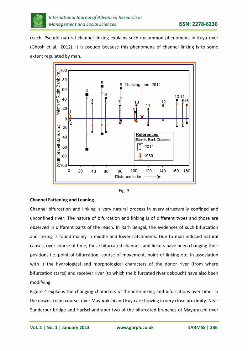
International Journal of Advanced Research in Management and Social Sciences ISSN: 2278-6236
Vol. 2 | No. 1 | January 2013 www.garph.co.uk IJARMSS | 236
reach. Pseudo natural channel linking explains such uncommon phenomena in Kuya river
(Ghosh et al., 2012). It is pseudo because this phenomena of channel linking is to some
extent regulated by man.
Fig. 3
Channel Fattening and Leaning
Channel bifurcation and linking is very natural process in every structurally confined and
unconfined river. The nature of bifurcation and linking is of different types and those are
observed in different parts of the reach. In Rarh Bengal, the evidences of such bifurcation
and linking is found mainly in middle and lower catchments. Due to man induced natural
causes, over course of time, these bifurcated channels and linkers have been changing their
positions i.e. point of bifurcation, course of movement, point of linking etc. In association
with it the hydrological and morphological characters of the donor river (from where
bifurcation starts) and receiver river (to which the bifurcated river debouch) have also been
modifying.
Figure 4 explains the changing characters of the interlinking and bifurcations over time. In
the downstream course, river Mayurakshi and Kuya are flowing in very close proximity. Near
Sundarpur bridge and Harischandrapur two of the bifurcated branches of Mayurakshi river

International Journal of Advanced Research in Management and Social Sciences ISSN: 2278-6236
Vol. 2 | No. 1 | January 2013 www.garph.co.uk IJARMSS | 237
have emanated and linked with Kuya river. Through course of movement, the directionality
of the bifurcated rivers has changed several times. Sometimes loss of one linker channel has
forced to form another one. Bifurcated channel has formed water logging e.g. Maldah
wetland due to lack of proper draining route of the bifurcated channel to the main river.
Link after main river course has changed several times both morphologically and
hydrologically. Often it is happened that after linking of bifurcated channel, the width of the
river has widened, volume of the discharge has risen up and over all the energy level or
working capacity of the receiver river Kuya has increased. This event is termed as Channel
Fattening. On the contrary, when one linker river has lost its existence, gradually link after
river course has become lean both in morphological stature and hydrological strength even
some cases total existence of the channel has disappeared (vide fig. 4). This phenomenon is
called river piracy.
The 1st bifurcated channels traversing the interfluves of Mayurakshi and Kuya has lost its
existence over course of time due to forceful embanking of the bifurcation site. Irrigation
and water way authority has erected this lofty embankment in this site to protect flood
along sides the bifurcated channel. After this forceful incident, Receiver River did not get
substantial amount of water and as a result the Kuya River reach in between 3rd linking site
and 4th linking site has become lean (vide fig. 4). It is an example of weakening or thinning of
river.

International Journal of Advanced Research in Management and Social Sciences ISSN: 2278-6236
Vol. 2 | No. 1 | January 2013 www.garph.co.uk IJARMSS | 238
Fig. 4
On the other hand after 4th linking site, the strength of the Kuya river course has increased.
In figure 5 site a and b are two sample locations of taking river cross section to prove the
influence of linker river on river Kuya. In section a (before linking of present linker fig. 6), the
width and depth as well as volume of discharge is less but after linking at site b (fig. 7) there
is sudden increase of all the mentioned hydro morphological parameters. This condition is
called channel fattening or channel thickening.
On the other hand the after bifurcation channel of Mayurakshi river has become sick in
morphological stature and hydrological strength. Before bifurcation, the width of the
channel is 424.9 m. (at site c) but it is only 162 m. after bifurcation of Mor river from
master stream river Mayurakshi River. In more downstream reach, the width of the channel

International Journal of Advanced Research in Management and Social Sciences ISSN: 2278-6236
Vol. 2 | No. 1 | January 2013 www.garph.co.uk IJARMSS | 239
has declined in significant extent. Width at the confluence stream is as narrow as only 16m.
This massive decline of width due to channel bifurcation and associated other causes is
known as channel leaning or channel weakening or channel thinning. As huge amount of
sediment and water is draining to the Kuya river, overall process of action reaction for both
the donor and receiver rivers have changed in very recognized or unrecognized dimensions.
Fig. 5
The concept of Misfit River is basically applied to describe disproportional width depth
condition, valley width and channel width condition, width depth and discharge ratio of the
river. If anyway width of the river increases or decreases downstream disproportionately in
reference to width of the existing upstream reaches, the river is called as Quasi Misfit River.
In this present study due to channel bifurcation, width of the master stream (Mayurakshi
River) has drastically reduced just downstream of channel bifurcation and width of the
receiver stream (Kuya River) has increased downstream just after linking of bifurcated
b
a
c d

International Journal of Advanced Research in Management and Social Sciences ISSN: 2278-6236
Vol. 2 | No. 1 | January 2013 www.garph.co.uk IJARMSS | 240
stream (Mor River) from Mayurakshi river. These altered forms of streams (both Mayurakshi
river and Kuya river) are known as Quasi misfit stream.
Fig. 6
Fig. 7
In figure 5, the present morphological condition of the same interfluves area has been
presented. It clearly shows that the first bifurcated channels or natural linkers have totally
lost their existence. People have occupied this river command area even river channel
through the extension of agriculture. Field survey, Oct., 2011 has also help to experience
this regretful incidence of river piracy or river thiefting by human being. According to bank
dwellers’ opinion, ceasing of river has helped to abate flood in this surrounding area of the
then bifurcated stream. But they have also confessed that the boro (summer) agriculture,
rabi crops have been hampered due to dying of this river because this river was used to
supply irrigation water for the command area. So, obviously, to reclaim the agriculture of

International Journal of Advanced Research in Management and Social Sciences ISSN: 2278-6236
Vol. 2 | No. 1 | January 2013 www.garph.co.uk IJARMSS | 241
the monsoon period, people have been committing sacrifice of the irrigation based
agriculture of the non monsoon season. Loss of river immediately forced to adopt a new set
of agricultural patter.
When it was asked to the people about the closing of the present bifurcated stream in the
old manner, they denied accepting this kind of alteration. They strongly revealed that after
flood condition is very congenial for both rabi and boro cultivation.
It should also be mentioned that this forceful closing of river will not absolute step to abate
flood conditions. Mayurakshi river has a natural tendency to bifurcate right ward. So to
close one source of bifurcation may encourage to several other sources of the same in some
other places. This evidence is very commonly found in river Mayurakshi and Kuya
interfluves. Figure 5 also highlights that the second bifurcation point has been shifting
forward. This forward wandering of the right side bifurcation of Mayurakshi river also
proves that forceful caution like embanking and restricting the source of the bifurcated
channel is not any judicious step against flood abatement. This step is only temporally
justified to shift the flood axis from one region to another but all on a sudden it may
increase jeopardy to the surrounding people. From this tendency of bifurcation, it could be
predicted that in next 20 years, 10 km. downstream of the river Mayurakshi from present
bifurcation point may be vulnerable point of bifurcation and as a result flood conditions of
the surrounding interfluves may be aggravated.
It is true that the pirated axes of the previously traversed rivers have a tendency of water
stagnation during monsoon period. The Mayurakshi Kuya interfluve is so flatter that back
waters of the downstream rivers may force the area to be flooded. Embanking and
restricting of bifurcated channel is just a temporary step toward flood abatement but
without giving adequate flood corridor this tendency could not be ceased permanently.

International Journal of Advanced Research in Management and Social Sciences ISSN: 2278-6236
Vol. 2 | No. 1 | January 2013 www.garph.co.uk IJARMSS | 242
Fig. 8
Fig. 9
Fig. 10
In fine, some planning strategies could be introduced which will help to cope up with altered
situations of river morphology and hydrology. Water availability before and after quasi
misfitting conditions are largely different and therefore, readjustment of land use cropping
practices etc. are necessary in the areas along sides of quasi misfit rivers. Moreover, it

International Journal of Advanced Research in Management and Social Sciences ISSN: 2278-6236
Vol. 2 | No. 1 | January 2013 www.garph.co.uk IJARMSS | 243
should also be mentioned that after misfitting, channel narrowing may constrict abundant
flow during monsoon period. Similarly, diversion of huge water from Donar River to
Receiver River may also creates exaggeration of water as well as may invite flood in the
downstream reach. To save the surrounding regions from such flood incidences,
construction of lofty embankment astride of river Kuya and Myurakshi again forced those
rivers to combat another process of new channel adjustment. Of course, this type of
phenomena is noticed both in case of Mayurakshi and Kuya river. So, river oriented planning
should be resettled accordingly in question of sustainability.
REFERENCES
1. Bloom, A.L., (1978). Geomorphology, Printice Hall of India Private Limited, New
Delhi.
2. Bloom, A.L., (1979). Geomorphology, Printice Hall of India Private Limited, New
Delhi.
3. Dury, G. H. (1958). Tests of a general theory of misfit streams. Inst. Br. Geogr., Trans.
Pap., 1958, Vol.25, 105–118.
4. Dury, G. H. (1964). Subsurface Exploration and Chronology of Underfit Streams.
Professional Paper no. 452-A. U.S. Geological Survey, Reston, Virginia.
5. Ghosh, K. et al. (2012). Assessment of the Hypothetical Trend of Morphological
Parameters: Kuya River Channel, Eastern India. International Journal of
Environmental Engineering and Management, Vol. 3, Number 1, pp. 37-44.
6. Leopold, L. B., Wolman, M. G. and Miller, J. P. (1964). Fluvial Processes in
Geomorphology. Eurasia Pub. House (Pvt.) Ltd. New Delhi-55. Pp 411-30.
7. Leopold, L.B. and T. Maddock, (1953). The hydraulic geometry of stream channels
and some physiographic implications, USGS Professional Paper 252, pp. 1-57.
8. Manville, Vern & Wilson, Colin J. N. (2004). The 26.5 ka Oruanui eruption, New
Zealand: a review of the roles of volcanism and climate in the post-eruptive
sedimentary response. New Zealand Journal of Geology & Geophysics vol. 47, No.3,
pp. 525–547.
9. Morisawa, M. E. (1968). Streams, their dynamics and morphology. Pubd. McGraw-
Hill Book Company, New York. P 175.
10. Morisawa, M., (1985). Rivers (Forms and Processes), Longman, London and New
York.

International Journal of Advanced Research in Management and Social Sciences ISSN: 2278-6236
Vol. 2 | No. 1 | January 2013 www.garph.co.uk IJARMSS | 244
11. Morisawa, M., (1985). Rivers (Forms and Processes), Longman, London and New
York.
12. Mukhopadhyay, S. & Pal, S. (2009). Impact of Tilpara Barrage on the Environment of
Mayurakshi Confluence Domain – A Granulometric Approach, Indian Journal of
Geomorphology, Vol. 13 & 14, No. 1 & 2., 2008-2009, pp. 179-187.
13. Mukhopadhyay, S., Mukhopadhyay, M. and Pal, S. (2010). Advance River Geography,
acb publication, Kolkata
14. Neuendorf, K.K.E., J.P. Mehl, Jr., and J.A. Jackson, J.A., eds. (2005). Glossary of
Geology (5th ed.). Alexandria, Virginia, American Geological Institute. pp 779.
15. Pal, S and Let, S. (2011). Channel Morphological Trend and Relationship Assessment
of Dwarka River, Eastern India, Global Journal of Applied Environmental Science,
Nov., 2011. Vol. 1, No. 3, pp.221-232
16. Pal, S. (2010). An Appraisal of Geo-economic Environment of Major Wetlands
Within Kandi Block, Murshidabad District, West Bengal, Ph. D. Thesis, Visva-
Bharati, Santiniketan, West Bengal.
17. Pal, S. (2011). River Flood: Dynamics. Detection. Prediction, Perspective of
Subtropical Region, Lambert Publication, Germany.
18. Pal, S. (2012). Changing Inundation Character in Mayurakshi River Basin: A Spatio
Temporal Review, Practising Geographer, Vol. 14, No. 1, September 2010, pp. 58-71.
19. Pal, S. (2012). Post Dam Hydro-geomorphic Alteration: A Study of Dwarka River,
Eastern India, International Journal of Applied Environmental Science, New York,
USA. pp. 24- 48.
20. Ray, C. (2001). The causes of flood of Sept.,2000 in West Bengal vis- a-vis the roles of
the Massanjore Dam and the Tilpara Barrage, Sechpatra, (1)
21. Richard, G.A. (2001). Quantification and Prediction of Lateral Channel Adjustments
Downstream from Cochiti Dam, Rio Grande, NM, Ph.D. Dissertation, Colorado State
University, Collins, CO.
22. Richards, K.S., (1973). Hydraulic geometry and channel roughness – a non-linear
system, American Journal of Science, Vol. 273, pp. 877-96.
23. Sinha, R. (1996). Channel avulsion and floodplain structure in the Gandak– Kosi
interfan, north Bihar plains, India, Z. Geomorphol. N.F. Suppl., Vol.103, 249–268.