international society of photogrammetry …openarchive.icomos.org/1120/1/3d_arch_2005.pdf ·...
TRANSCRIPT
INTERNATIONAL SOCIETY OF PHOTOGRAMMETRY AND REMOTE SENSING INTERNATIONALE GESELLSCHAFT Fܒ PHOTOGRAMMETRIE UND
FERNERKUNDUNG SOCIETE INTERNATIONALE DE PHOTOGRAMMETRIE ET DE TELEDETECTION
Proceedings of the ISPRS Working Group V/4 Workshop 3D-ARCH 2005:
"Virtual Reconstruction and Visualization of Complex Architectures" Mestre-Venice, Italy, 22-24 August, 2005
Editors: Sabry El-Hakim, Fabio Remondino, Lorenzo Gonzo
International Archives of Photogrammetry, Remote Sensing and Spatial Information SciencesVOLUME XXXVI, PART 5/W17
ISSN 1682-1777
Papers accepted on the basis of peer-reviewed full manuscripts
Organized by ISPRS Commission V WG 4
NRC-CNRC National Research Council Canada Institute of Geodesy and Photogrammetry, ETH Zurich, Switzerland
IRST - ITC Trento, Italy
Copies of the Proceedings are available from: GITC bv
PO Box112 8530 AC Lemmer The Netherlands
Fax: +31-514-56185 Email: [email protected]
? 2005 remains with the authors(s) of a paper except where it is retained by the authors employer
Table of contents:
TS1 - METRIC 3D RECONSTRUCTION
Chairman: Sabry El-Hakim
Network Orientation Models for Image-Based 3D Measurement Clive Fraser (Melbourne University, Australia) - Invited Paper Suitability Assessment of Ground Level Imagery for Geospatial VR Modeling T. Stefanidis, Ch. Georgiadis, G. Mountrakis (University of Maine, USA)
TS2 - COMBINED 3D TECHNIQUES
Chairman: Henrik Haggren
Using Multiple Scanning Technologies for the 3D Acquisition of Torcello's Basilica M. Balzani (Univ. of Ferrara, Italy), M. Callieri (ISTI-CNR, Pisa, Italy), G. Caputo (Diocesi Patriarcato, Venezia, Italy), P. Cignoni, M. Dellepiane, C. Montani, P. Pingi, F. Ponchio, R. Scopigno (ISTI-CNR, Pisa, Italy), A. Tomasi (Univ. of Pisa, Italy), F. Uccelli (Univ. of Ferrara, Italy) Combined 3D Surveying Techniques for Structural Analisys Applications A. Guarnieri, F. Pirotti, M. Pontin, A. Vettore (CIRGEO, Univ. of Padua, Italy) 3D Reconstruction of Complex Architectures from Multiple Data S. El-Hakim (VIT-NRC, Canada), E. Whiting (MIT, USA), L. Gonzo, S. Girardi (ITC, Trento, Italy) 3D Modeling Of High Relief Sculpture Using Image Based Integrated Measurement System T. Odake, H. Chikatsu (Tokyo Denki University, Japan)
TS3 - LASER SCANNER APPLICATION
Chairman: Henrik Haggren
First Experiences with a Mobile Platform for Flexible 3D Model Acquisition in Indoor and Outdoor Environments - The Waegele P. Biber, S. Fleck, D. Staneker, M. Wand, W. Strasser (University of Tubingen, Germany) Terrestrial Laser Scanning - Applications In Cultural Heritage Conservation and Civil Engineering T. Abmayr, F. H l, M. Reink?r, C. Fr?ch (Zoller + Fr?ch (Z+F) GmbH, Germany) 3D Modeling of Outdoor Scenes by Integrating Stop-And-Go and Continuous Scanning of Rangefinder T. Asai, M. Kanbara, N. Yokoya (Nara Institute of Science and Technology, Japan)

TS4 - LASER SCANNER APPLICATION
Chairman: Armin Gruen
Marker-Free Registration of Terrestrial Laser Scans Using the Normal Distribution Transform N. Ripperda, C. Brenner (IKG-University of Hannover, Germany) Georeferencing of Terrestrial Laser scanner Data for Applications in Architectural Modeling S. Schuhmacher, J. B?(IfP-University of Stuttgart, Germany) Direct Georeferencing of Tls in Surveying of Complex Sites M. Scaioni (DIIAR-Politecnico of Milano, Italy) Ordering Criteria for Information Management in 3D Laser Surveying of Small Urban Spaces J. Finat, L. Fuentes, J.J. Fern�ez-Mart� J. Mart�z-Rubio, J.I. San Jos頨Univ. of Valladolid, Spain)
TS5 - 3D TECHNIQUES FOR HERITAGE APPLICATIONS
Chairman: Clive Fraser
Photogrammetric Documentation and Modelling of an Archaelogical Site: The Fonnish Jabal Haroun Project H. Haggren (Helsinki University, Finland) - Invited Paper Recording and Modeling an Aboriginal Cave Painting: With or Without Laser Scanning? J. Fryer, J.H. Chandler (University of Newcastle, Australia), S. El-Hakim (VIT-NRC, Canada)Long-Term Preservation of 3D Cultural Heritage Data Related to Architectural Sites E. Paquet (VIT-NRC, Canada), H.L. Viktor (University of Ottawa, Canada)
TS6 - MODELING OF COMPLEX SITES AND OBJECTS
Chairman: John Fryer
New Technologies for Efficient Large Site Modeling A. Gruen (IGP-ETH Zurich, Switzerland) Strategy for the Extraction of 3D Architectural Objects from Laser and Image Data Acquired from the Same Viewpoint M. Deveau, N. Paparoditis, M. Pierrot-Deseilligny, (IGN/MATIS, France), X. Chen (MENSI, France), G. Thibault, (EDF R&D, France) The Colored Comparison of The Wall Sculpture with 3D Laser Scanner and Orthophoto H. Kurashige, J. Kato, S. Nishimura (Keisoku Research Consultant, Japan)
TS7 - 3D MODELING FOR VR APPLICATION
Chairman: Fabio Remondino
The Monuments Restoration Yard: a Virtualization Method and the Case of Study of Sala
delle Cariatidi in Palazzo Reale, Milan M. Gaiani, L.L. Micoli, M. Russo, (INDACO-Politecnico of Milano, Italy) - Invited Paper The Roman Theatre of Clvnia: Hybrid Strategies for Applying Virtual Reality on Laser Scanning 3D Files J. Finat, M.A. Iglesia Santamar� J. Mart�z Rubio, J.J. Fern�ez Mart� L. Giuntini, J.I. San Jos頁lonso, A. Tapias (University of Valladolid, Spain) Image Orientation for Interactive Tours of Virtually-Modeled Sites C. Georgiadis, T. Stefanidis, S. Gyftakis, P. Agouris (University of Maine, USA) A New Method for Vanishing Point Detection in 3D Reconstruction from a Single View D.G. Aguilera, J. G� Lahoz (Univ. of Salamanca, Spain), J. Finat Codes (Univ. of Valladolid, Spain)
TS8 - POSTER SESSION & VIDEO THEATRE
Chairman: Lorenzo Gonzo
Sv3dvision: 3D Reconstruction and Visualization From a Single View D.G. Aguilera, J. G� Lahoz (Univ. of Salamanca, Spain), J. Finat Codes (Univ. of Valladolid, Spain) Openheritage: Integrated Approach to Web 3D Publication of Virtual Landscape L. Calori, C. Camporesi (CINECA, Italy), M. Forte (CNR, Italy), A. Guidazzoli (CINECA, Italy), S. Pescarin (CNR, Italy) A Method on Modeling and Visualization of 3D Objects W.Zhi, L.Qingquan L.Yuguang (Wuhan University, China) A Survey of The Sala Degli Stucchi, an Ornate Baroque Hall C. Porporato, F. Rinaudo (Politecnico of Turin, Italy) Towards a 3D True Colored Space by the Fusion of Laser Scanner Point Cloud and Digital Photos A. Abdelhafiz, B. Riedel, W. Niemeier (Universit Braunschweig, Germany)
TS9 - ARCHITECTURAL IMAGE-BASED MODELING
Chairman: Jan Boehm
3D Building Facade Reconstruction Under Mesh Form from Multiple Wide Angle Views L. P鮡rd, N. Paparoditis, M. Pierrot-Deseilligny (IGN/MATIS, France) Generation of Occlusion-free Images for Realistic Texture Mapping D. Ortin (University of Zaragoza, Spain), F. Remondino (IGP-ETH Zurich, Switzerland)
TS10 - ARCHITECTURAL RANGE-BASED MODELING
Chairman: Marco Gaiani

3D Modeling of Structures Using Break-Lines and Corners in 3D Point Cloud Data H. Yokoyama, H. Chikatsu (Tokyo Denki University, Japan) 3D Laser Scanner Aimed to Architectural Heritage Survey: From The Point?s Cloud to the Geometrical Genesis Determination C. Santagati (University of Catania, Italy) The Creation of The 3D Solid Model by Laser Scanning: The Old Sacristy by Brunelleschi in Florence G. Fangi, E. Malinverni (Universita' Politecnica delle Marche, Italy)
3D LASER SCANNER AIMED TO ARCHITECTURAL HERITAGE SURVEY: FROM THE POINT’S CLOUD TO THE GEOMETRICAL GENESIS DETERMINATION
C. Santagati a
a University of Catania, Engineering Faculty, Dept. Of Architecture and Town-planning, Lab. of Architectural Photogrammetry andSurvey, Viale A. Doria,6 - 95125 Catania, Italy email: [email protected]
KEY WORDS: Architectural heritage, Laser scanning, point clouds, 3D modelling
ABSTRACT:
The present essay is a result of a wider research we are conducting at the Laboratory of Architectural Photogrammetry and Survey ofCatania directed by professor Luigi Andreozzi. The research concerns the experimentation on the scanner laser methodology appliedto the study, the analysis and the documentation of the architectural heritage.The use of this new technology needs a critical approach in data acquisition and processing for a possible intervention aimed to study,document and represent the intrinsic characteristics of architectonic monuments. This is done to evaluate both the capacities enclosedby this methodology (high density cloud of points which describes exhaustively the morphology of spaces and objects of variousshape and geometry, in situ surveying times' reduction, consciousness of instruments' accuracy, surveying procedures' real timechecking ) and the integration of obtained results with the other surveying methods to be useful in the dialogue between informationusers and information providers. The case here presented concerns the study of the vaulted system which covers the so-called Small Refectory of the Benedictine’smonastery in Catania, designed in 1739 by a clever architect, G. B. Vaccarini. Because of its peculiar shape, for quite a time this roomhave been the centre of scholar diatribes in order to find out the geometrical genesis of its planimetric outline and arched ceiling.Research work has been conducted starting from the raw data which outcome from each single scan and applying different sofwaresto elaborate the cloud of points in order to recognize studied surfaces geometrical origin, to build possibile virtual models able todocument and express the geometrical-morphological-materical essence of the vaulted room analyzed.
1. INTRODUCTION
The perception of a "built" space, as we can see when dealingwith an architectural organism, is pointed out by its shape,structure, in a word by its geometry, so that a traditional two-dimension representation is inadequate to represent the spatialityof a certain room or of a single object.In particular, this happens when studying the geometrical naturesubtending particularly complex elements' structure, as whenanalyzing vaulted systems. In this case, the use of 3D laserscansion has proved to be the better strategy in comparison withthe traditional surveying methods, because of these systems'remarkable geometrical complexity and inaccessibility. Indeed,thanks to the quickness of the survey, the instrument's highprecision and the possibility of detailing the surveyed points'density, we managed to obtain, in the shortest time, a vaultnumerical model rich in metric information which was useful tounderstand the geometric genesis of its surfaces .Moreover, thanks to a survey in which the acquired pointsappear as space co-ordinates and each point displayed on themonitor screen represents an actual point, we were capable,since the data acquisition stage, of interacting with the three-dimensionality of the numerical model obtained, by rotating itinto the computer virtual space and by observing it fromdifferent points of view. By using different kinds of software in data processing, weextrapolated from the 3d model all the information (cross-sections, profiles, contour lines, 3D views) suitable for thedetermination of the studied element's geometrical andmorphological features, in order to reconstruct the formergeometrical idea by critically and interactively analyzing theapproach with reality. Besides, in the case of vaulted systems, graphic tracing and
building techniques are strictly interlaced; so it was essential tomake reference to the handbooks of the period in order to carryout all the explanatory hypothesis fit to recognize the analyzedsurfaces' geometrical genesis.
2. A CASE OF STUDY: THE BENEDETTINI'SMONASTERY REFETTORIO PICCOLO VAULTED
SYSTEM
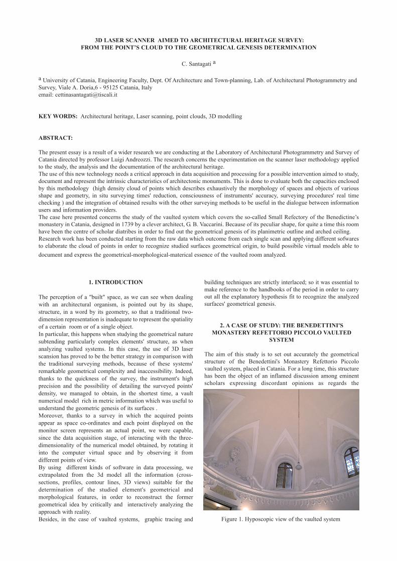
The aim of this study is to set out accurately the geometricalstructure of the Benedettini's Monastery Refettorio Piccolovaulted system, placed in Catania. For a long time, this structurehas been the object of an inflamed discussion among eminentscholars expressing discordant opinions as regards the
Figure 1. Hyposcopic view of the vaulted system
geometrical nature of the plan, of the vaulted surface andlunettes intrados.The Benedettini's Monastery was re-built by arch. AntoninoAmato immediately after 1693 earthquake that razed to theground most of the city's buildings. In 1739 arch. G. B. Vaccarinitook the place of arch. F. Battaglia who had had someincomprehensions with the client monks. Vaccarini planned andrealised the monastery north side that includes the RefettorioPiccolo, the Refettorio Grande and the Antirefettorio. Just forthese refectories, he designed two oval plan rooms covered by adomed vault and lighted by lunettes which start from the vault'sspringer (Fichera 1934; Giarrizzo 1990).We can enter the Refettorio Piccolo room through two entrancesplaced along the major axis whose dimension is of 15.80m(equal to 80 palmi, unit of measurement of the period), while theminor axis is of 13.50 m (60 palmi) and the maximum heightreferred to the keystone is about 13.10 m.
2.1 Data acquisition and processing
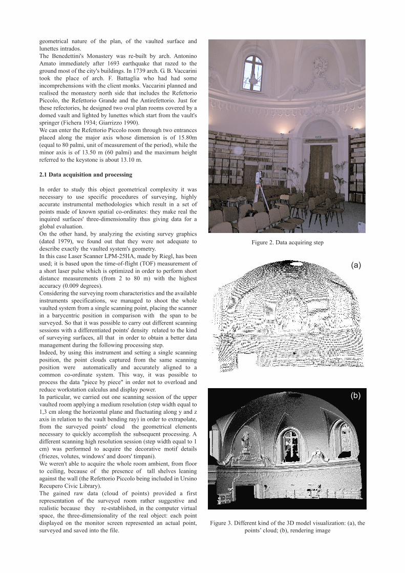
In order to study this object geometrical complexity it wasnecessary to use specific procedures of surveying, highlyaccurate instrumental methodologies which result in a set ofpoints made of known spatial co-ordinates: they make real theinquired surfaces' three-dimensionality thus giving data for aglobal evaluation.On the other hand, by analyzing the existing survey graphics(dated 1979), we found out that they were not adequate todescribe exactly the vaulted system's geometry. In this case Laser Scanner LPM-25HA, made by Riegl, has beenused; it is based upon the time-of-flight (TOF) measurement ofa short laser pulse which is optimized in order to perform shortdistance measurements (from 2 to 80 m) with the highestaccuracy (0.009 degrees).Considering the surveying room characteristics and the availableinstruments specifications, we managed to shoot the wholevaulted system from a single scanning point, placing the scannerin a barycentric position in comparison with the span to besurveyed. So that it was possible to carry out different scanningsessions with a differentiated points' density related to the kindof surveying surfaces, all that in order to obtain a better datamanagement during the following processing step. Indeed, by using this instrument and setting a single scanningposition, the point clouds captured from the same scanningposition were automatically and accurately aligned to acommon co-ordinate system. This way, it was possible toprocess the data "piece by piece" in order not to overload andreduce workstation calculus and display power. In particular, we carried out one scanning session of the uppervaulted room applying a medium resolution (step width equal to1,3 cm along the horizontal plane and fluctuating along y and zaxis in relation to the vault bending ray) in order to extrapolate,from the surveyed points' cloud the geometrical elementsnecessary to quickly accomplish the subsequent processing. Adifferent scanning high resolution session (step width equal to 1cm) was performed to acquire the decorative motif details(friezes, volutes, windows' and doors' timpani). We weren't able to acquire the whole room ambient, from floorto ceiling, because of the presence of tall shelves leaningagainst the wall (the Refettorio Piccolo being included in UrsinoRecupero Civic Library).The gained raw data (cloud of points) provided a firstrepresentation of the surveyed room rather suggestive andrealistic because they re-established, in the computer virtualspace, the three-dimensionality of the real object: each pointdisplayed on the monitor screen represented an actual point,surveyed and saved into the file.
Figure 2. Data acquiring step
Figure 3. Different kind of the 3D model visualization: (a), thepoints’ cloud; (b), rendering image
(a)
(b)
Through subsequent steps raw data were checked according tothe points distance and intensity, cleaned and filtered in order toreduce noise and remove invalid points.
2.2 3D virtual model analysis
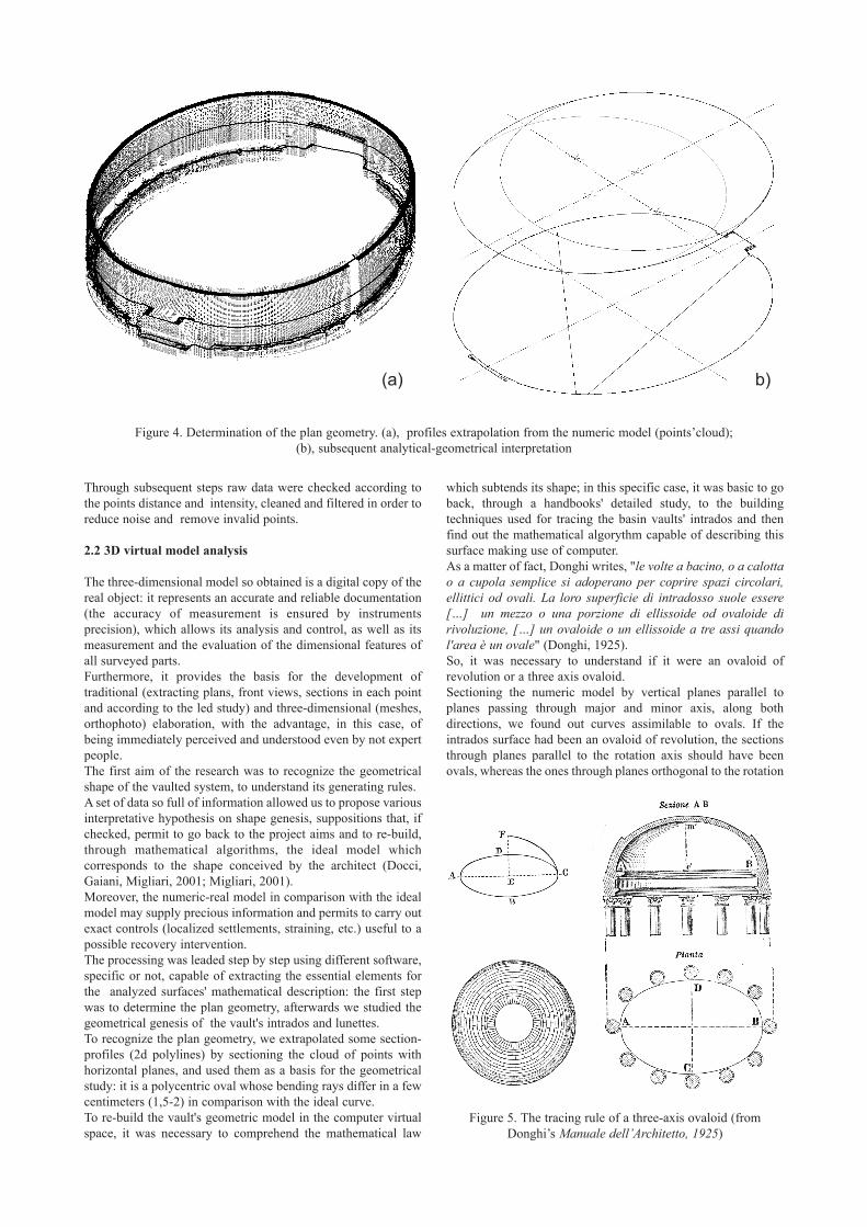
The three-dimensional model so obtained is a digital copy of thereal object: it represents an accurate and reliable documentation(the accuracy of measurement is ensured by instrumentsprecision), which allows its analysis and control, as well as itsmeasurement and the evaluation of the dimensional features ofall surveyed parts.Furthermore, it provides the basis for the development oftraditional (extracting plans, front views, sections in each pointand according to the led study) and three-dimensional (meshes,orthophoto) elaboration, with the advantage, in this case, ofbeing immediately perceived and understood even by not expertpeople. The first aim of the research was to recognize the geometricalshape of the vaulted system, to understand its generating rules.A set of data so full of information allowed us to propose variousinterpretative hypothesis on shape genesis, suppositions that, ifchecked, permit to go back to the project aims and to re-build,through mathematical algorithms, the ideal model whichcorresponds to the shape conceived by the architect (Docci,Gaiani, Migliari, 2001; Migliari, 2001). Moreover, the numeric-real model in comparison with the idealmodel may supply precious information and permits to carry outexact controls (localized settlements, straining, etc.) useful to apossible recovery intervention.The processing was leaded step by step using different software,specific or not, capable of extracting the essential elements forthe analyzed surfaces' mathematical description: the first stepwas to determine the plan geometry, afterwards we studied thegeometrical genesis of the vault's intrados and lunettes. To recognize the plan geometry, we extrapolated some section-profiles (2d polylines) by sectioning the cloud of points withhorizontal planes, and used them as a basis for the geometricalstudy: it is a polycentric oval whose bending rays differ in a fewcentimeters (1,5-2) in comparison with the ideal curve. To re-build the vault's geometric model in the computer virtualspace, it was necessary to comprehend the mathematical law
which subtends its shape; in this specific case, it was basic to goback, through a handbooks' detailed study, to the buildingtechniques used for tracing the basin vaults' intrados and thenfind out the mathematical algorythm capable of describing thissurface making use of computer. As a matter of fact, Donghi writes, "le volte a bacino, o a calottao a cupola semplice si adoperano per coprire spazi circolari,ellittici od ovali. La loro superficie di intradosso suole essere[…] un mezzo o una porzione di ellissoide od ovaloide dirivoluzione, […] un ovaloide o un ellissoide a tre assi quandol'area è un ovale" (Donghi, 1925). So, it was necessary to understand if it were an ovaloid ofrevolution or a three axis ovaloid.Sectioning the numeric model by vertical planes parallel toplanes passing through major and minor axis, along bothdirections, we found out curves assimilable to ovals. If theintrados surface had been an ovaloid of revolution, the sectionsthrough planes parallel to the rotation axis should have beenovals, whereas the ones through planes orthogonal to the rotation
Figure 4. Determination of the plan geometry. (a), profiles extrapolation from the numeric model (points’cloud); (b), subsequent analytical-geometrical interpretation
Figure 5. The tracing rule of a three-axis ovaloid (fromDonghi’s Manuale dell’Architetto, 1925)
(a) (b)
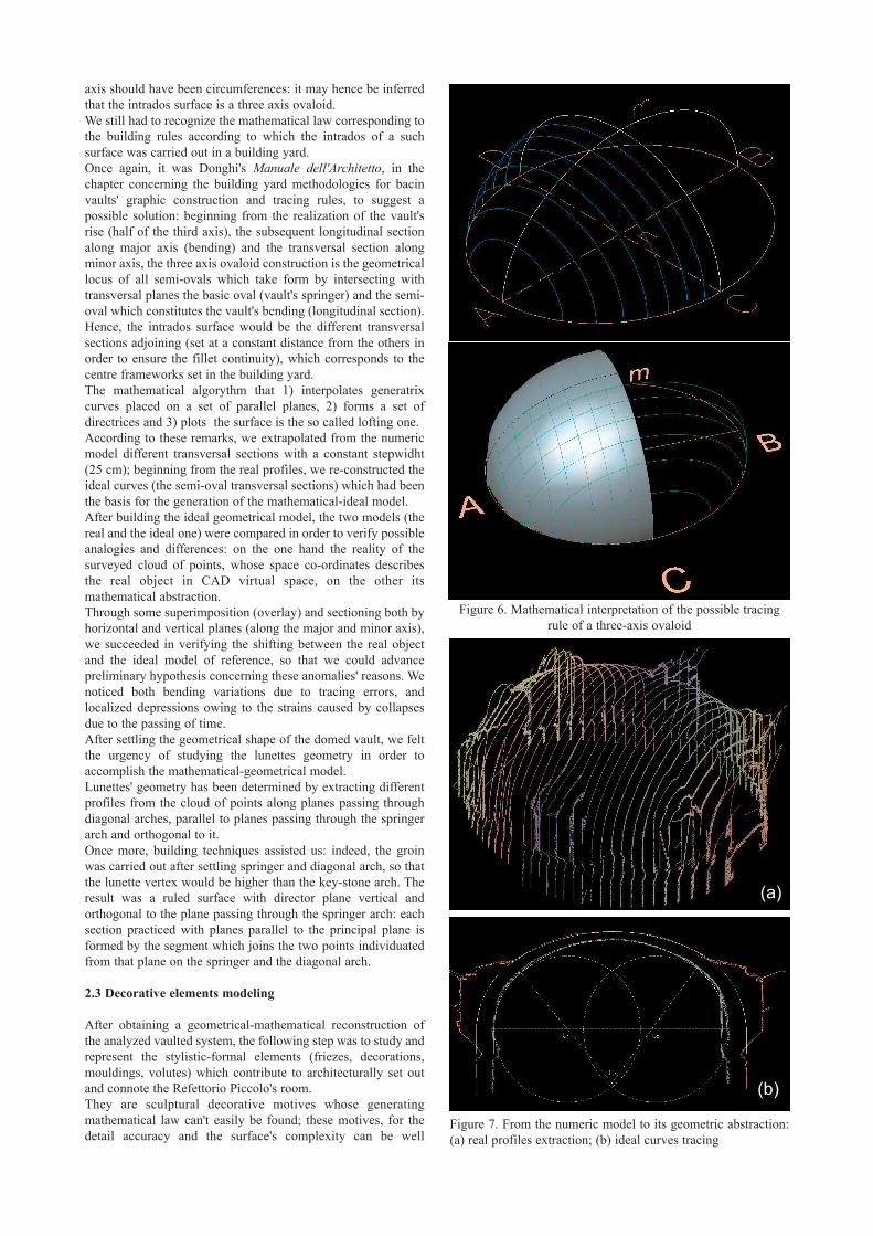
axis should have been circumferences: it may hence be inferredthat the intrados surface is a three axis ovaloid.We still had to recognize the mathematical law corresponding tothe building rules according to which the intrados of a suchsurface was carried out in a building yard.Once again, it was Donghi's Manuale dell'Architetto, in thechapter concerning the building yard methodologies for bacinvaults' graphic construction and tracing rules, to suggest apossible solution: beginning from the realization of the vault'srise (half of the third axis), the subsequent longitudinal sectionalong major axis (bending) and the transversal section alongminor axis, the three axis ovaloid construction is the geometricallocus of all semi-ovals which take form by intersecting withtransversal planes the basic oval (vault's springer) and the semi-oval which constitutes the vault's bending (longitudinal section).Hence, the intrados surface would be the different transversalsections adjoining (set at a constant distance from the others inorder to ensure the fillet continuity), which corresponds to thecentre frameworks set in the building yard.The mathematical algorythm that 1) interpolates generatrixcurves placed on a set of parallel planes, 2) forms a set ofdirectrices and 3) plots the surface is the so called lofting one. According to these remarks, we extrapolated from the numericmodel different transversal sections with a constant stepwidht(25 cm); beginning from the real profiles, we re-constructed theideal curves (the semi-oval transversal sections) which had beenthe basis for the generation of the mathematical-ideal model. After building the ideal geometrical model, the two models (thereal and the ideal one) were compared in order to verify possibleanalogies and differences: on the one hand the reality of thesurveyed cloud of points, whose space co-ordinates describesthe real object in CAD virtual space, on the other itsmathematical abstraction.Through some superimposition (overlay) and sectioning both byhorizontal and vertical planes (along the major and minor axis),we succeeded in verifying the shifting between the real objectand the ideal model of reference, so that we could advancepreliminary hypothesis concerning these anomalies' reasons. Wenoticed both bending variations due to tracing errors, andlocalized depressions owing to the strains caused by collapsesdue to the passing of time.After settling the geometrical shape of the domed vault, we feltthe urgency of studying the lunettes geometry in order toaccomplish the mathematical-geometrical model.Lunettes' geometry has been determined by extracting differentprofiles from the cloud of points along planes passing throughdiagonal arches, parallel to planes passing through the springerarch and orthogonal to it. Once more, building techniques assisted us: indeed, the groinwas carried out after settling springer and diagonal arch, so thatthe lunette vertex would be higher than the key-stone arch. Theresult was a ruled surface with director plane vertical andorthogonal to the plane passing through the springer arch: eachsection practiced with planes parallel to the principal plane isformed by the segment which joins the two points individuatedfrom that plane on the springer and the diagonal arch.
2.3 Decorative elements modeling
After obtaining a geometrical-mathematical reconstruction ofthe analyzed vaulted system, the following step was to study andrepresent the stylistic-formal elements (friezes, decorations,mouldings, volutes) which contribute to architecturally set outand connote the Refettorio Piccolo's room. They are sculptural decorative motives whose generatingmathematical law can't easily be found; these motives, for thedetail accuracy and the surface's complexity can be well
Figure 7. From the numeric model to its geometric abstraction:(a) real profiles extraction; (b) ideal curves tracing
Figure 6. Mathematical interpretation of the possible tracingrule of a three-axis ovaloid
(a)
(b)
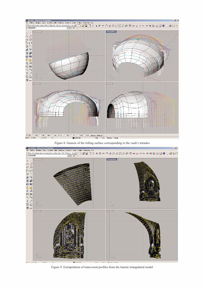
Figure 8. Genesis of the lofting surface corresponding to the vault’s intrados
Figure 9. Extrapolation of transversal profiles from the lunette triangulated model
approximated and graphically represented by using meshsurfaces (triangle one). In this way creating a triangle for eachadjacent trio of points the effect is to generate a coherent visualsurface beginning from a discreet point cloud model. In this step, data has been elaborated using JRC Reconstructorsoftware by Inn. tec. srl. Setting pre-processing and triangulating parameters (such asmesh triangle dimension, number and density) according todrawing surfaces features, it was possible to obtain a goodsculptural elements' representation and documentation,simplifying surfaces without losing decorative and plasticdetails. The holes due to missing data (the pronounced sculpturesoverhung hided the visibility of some object's portion) could befilled with additional scanning to complete the surveyed model.However, where possible, they were filled through properalgorithms which automatically created triangles in the shadowareas. The method was useful to explore the vaulted system spatiality,choosing different points of view and the best kind of mesh'svisualization (wireframe, flat or textured), according to theanalysis to be carried out.The acquisition of material, chromatic and degraded data wasobtained through the projection of the photographic images on
respective point clouds, collimating several well distributed andvisible equivalent points and the successive application of theprojected images on the continuous mesh model, in order to takethe best advantage from the high resolution of photos.
3. CONCLUSIONS
The research developed up to now has permitted to use laserscanning and the subsequent 3d digital model in a critical andoptimized manner. The result has been: on one hand thepossibility of a documentation exclusively aimed to the accuracyof measurement and to the punctual reproduction of the studiedobject, on the other one the opportunity to formulate differenthypothesis on the shape genesis in order to simulate and torecognize the project idea (Migliari, 2001). Therefore the study will be prosecuted towards the definitionand realization of possible virtual models apt to document andconvey the geometrical-morphological essence and the formaloutline of the inquired vaulted space.In fact, through the synthetical view given by a digital 3D modelan immediate approach to the object is assured so as to makeeasier both its communication and understanding even to not-expert people.
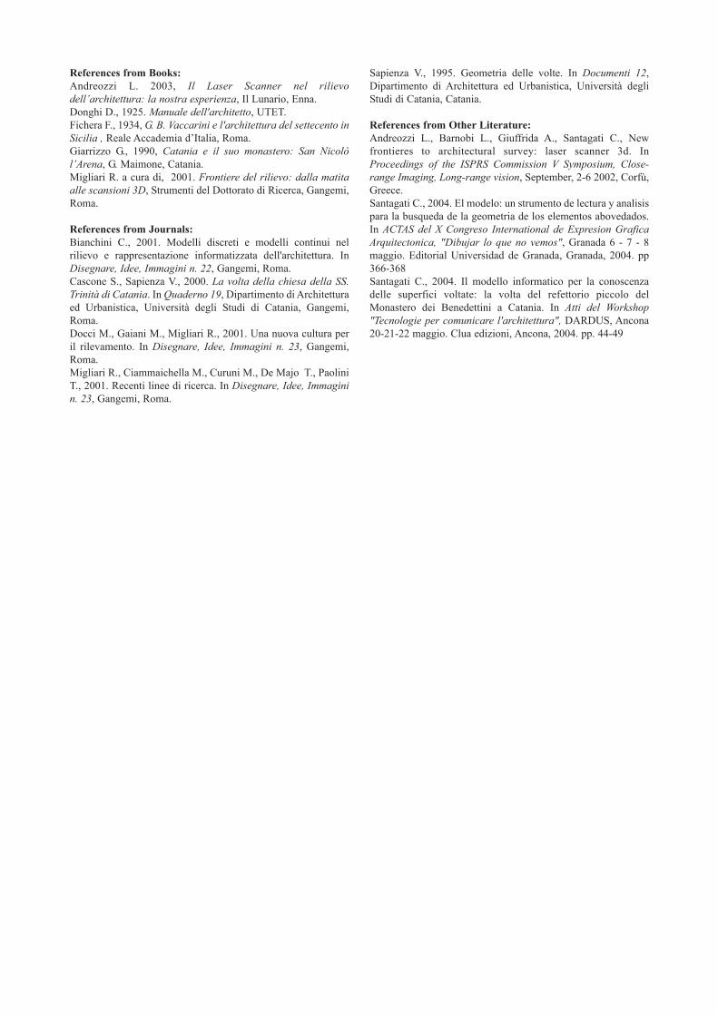
Figure 11. Decorative motif detail. The suggestive representation by means of point’s cloud (b) compared with the photographic image
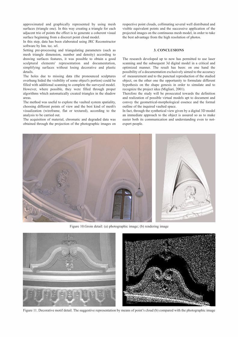
Figure 10.Groin detail: (a) photographic image; (b) rendering image

Figure 16. Decorative motif map shading model Figure 17. Decorative motif textured model
Figure 14. Decorative motif wireframe model Figure 15. Decorative motif map shading model
Figure 12. Decorative motif cloud of points Figure 13. Decorative motif map shading model
References from Books:Andreozzi L. 2003, Il Laser Scanner nel rilievodell’architettura: la nostra esperienza, Il Lunario, Enna.Donghi D., 1925. Manuale dell'architetto, UTET.Fichera F., 1934, G. B. Vaccarini e l'architettura del settecento inSicilia , Reale Accademia d’Italia, Roma.Giarrizzo G., 1990, Catania e il suo monastero: San Nicolòl’Arena, G. Maimone, Catania.Migliari R. a cura di, 2001. Frontiere del rilievo: dalla matitaalle scansioni 3D, Strumenti del Dottorato di Ricerca, Gangemi,Roma.
References from Journals:Bianchini C., 2001. Modelli discreti e modelli continui nelrilievo e rappresentazione informatizzata dell'architettura. InDisegnare, Idee, Immagini n. 22, Gangemi, Roma.Cascone S., Sapienza V., 2000. La volta della chiesa della SS.Trinità di Catania. In Quaderno 19, Dipartimento di Architetturaed Urbanistica, Università degli Studi di Catania, Gangemi,Roma.Docci M., Gaiani M., Migliari R., 2001. Una nuova cultura peril rilevamento. In Disegnare, Idee, Immagini n. 23, Gangemi,Roma.Migliari R., Ciammaichella M., Curuni M., De Majo T., PaoliniT., 2001. Recenti linee di ricerca. In Disegnare, Idee, Immaginin. 23, Gangemi, Roma.
Sapienza V., 1995. Geometria delle volte. In Documenti 12,Dipartimento di Architettura ed Urbanistica, Università degliStudi di Catania, Catania.
References from Other Literature:Andreozzi L., Barnobi L., Giuffrida A., Santagati C., Newfrontieres to architectural survey: laser scanner 3d. InProceedings of the ISPRS Commission V Symposium, Close-range Imaging, Long-range vision, September, 2-6 2002, Corfù,Greece.Santagati C., 2004. El modelo: un strumento de lectura y analisispara la busqueda de la geometria de los elementos abovedados.In ACTAS del X Congreso International de Expresion GraficaArquitectonica, "Dibujar lo que no vemos", Granada 6 - 7 - 8maggio. Editorial Universidad de Granada, Granada, 2004. pp366-368Santagati C., 2004. Il modello informatico per la conoscenzadelle superfici voltate: la volta del refettorio piccolo delMonastero dei Benedettini a Catania. In Atti del Workshop"Tecnologie per comunicare l'architettura", DARDUS, Ancona20-21-22 maggio. Clua edizioni, Ancona, 2004. pp. 44-49