interoperability between inspire, gmes, and geoss: what
TRANSCRIPT

Interoperability between
INSPIRE, GMES, and GEOSS:
What has been learned?
Stefano Nativi
CNR-IIA and EuroSIF

INSPIRE Plenary Meeting– Edinburgh, 27 Jun 2011 GIGA
S
Final
Boundary conditions [GIGAS]Characteristics GMES INSPIRE GEOSS
Policy owner European Commission
(DG ENTR), assisted by
GMES Steering Board
European Commission (DG
ENV), assisted by
INSPIRE CT
GEO Member States,
European Commission,
assisted by the GEO
Executive Committee
Paymaster EC, ESA EU Member States
FP7 (INFSO, RTD)
CIP (INFSO)
GEO Member States,
Participating orgs,
FP7, GMES,INSPIRE
Distance to decision
maker
Long Short Medium
Stakeholder potential to
influence initiative
Through activities
organized by projects
and fora, GMES
Advisory Council,
(Future Partners
Board)
Direct participation Participation in GEO Tasks
Indirectly, via Participating
Organisations (e.g. OGC,
IEEE, DE)

INSPIRE Plenary Meeting– Edinburgh, 27 Jun 2011
Introduction
• There exists a liaison group among GMES, INSPIRE and
GEOSS for interoperability [promoted by GIGAS]
• Fostered the use of and maintained a technology watch and
comparative analysis
• Sustained a communication platform, interoperability
workshops (CEN TC287, OGC), and the GEO SIF European
Team
• Exploit and nurture the knowledge base, the network, and
sustain shaping activities (CEN TC287, OGC)
• Coordination of EU programmes and projects
• Establish a permanent testing infrastructure

INSPIRE Plenary Meeting– Edinburgh, 27 Jun 2011
Introduction• EC/FP7 projects dealing with interoperability requirements from INSPIRE,
GMES, and GEOSS
– FP7 GIGAS
– FP7 EuroGEOSS
– FP7 GEO-WOW
• GEOSS IP3 and AIP (phases 2, 3, and 4)
– Including pilots stemming from GMES and INSPIRE activities
• GEO ADC and SIF workshops and meetings
– SIF white paper on interoperability gaps and EuroSIF discussions
• CEN TC 287 Workshops
– TR 15449 – SDI reference model
• OGC Domain Working Groups and interoperability workshops
– e.g. MeteoOcean, Hydrology, Coverage, etc.
– OGC best practice –e.g. GIGAS gap analysis deliverable

INSPIRE Plenary Meeting– Edinburgh, 27 Jun 2011
Interoperability Types
• Inter-disciplinary
• Cross-disciplinary
• Multi-disciplinary
• Technological
• Semantic
• Organizational
• Local
• Regional
• Global
• CC
• C

INSPIRE Plenary Meeting– Edinburgh, 27 Jun 2011
The Interoperability Space
0
5
10
15
20
25
30
35
40
Disciplinary
Cross-disciplinary
Multi-disciplinary
Semantic
Technological
Organizational
INSPIRE
GMES
GEOSS

INSPIRE Plenary Meeting– Edinburgh, 27 Jun 2011
Present Interoperability Levels
1. Distributed Data interoperability (DISCIPLINARY infrastructures on the WEB)– Build on Distributed Capacity provision functionalities
2. Geospatial Data interoperability (CROSS-DISCIPLINARY infrastructures
applying INSPIRE and using GMES services)– Geospatial resources core functionalities
3. Earth Observation interoperability (MULTI-DISCIPLINARY infrastructures
applying GEOSS approach)– CoP/SBA resources core functionalities
Distributed Computing Distributed Computing Distributed Computing Distributed Computing Infrastructure (s)
Geospatial Information Geospatial Information Geospatial Information Geospatial Information Infrastructure
MultiMultiMultiMulti----disciplinary disciplinary disciplinary disciplinary Infrastructure
Domain
Semantics

INSPIRE Plenary Meeting– Edinburgh, 27 Jun 2011
Interoperability Gaps
• Interoperability gaps and challenges recognized –GEO
ADC workshops, SIF analysis, etc.
– Support semantic interoperability• Inter-disciplinary, cross-disciplinary, multi-disciplinary
• Data Model composability
– Support Interoperability standards heterogeneity• Adopt international standards and Recognize community standards
– Support complex resources –not only data and
services• Environmental models, workflows, vocabularies, sensors, documents, etc.
– Support advanced functionalities• Discovery, evaluation, access, use

INSPIRE Plenary Meeting– Edinburgh, 27 Jun 2011
Technical Interoperability gaps [GIGAS]
• OGC /ISO developed standards through a bottom-up
consensus process, based on a relatively weak architectural
oversight
• There is a tendency towards proliferation of minor
incompatibilities
• Examples
– OWS common metadata don’t map to ISO 19119 service metadata
structure or its content
– Remote sensing and fluid-earth communities primarily use a field
oriented view (Coverage). While, GI community mostly follows the
'GIS' traditional feature oriented view
– A third approach has emerged the Sensor-enabled view

INSPIRE Plenary Meeting– Edinburgh, 27 Jun 2011
Flexibility needs [OGC]
• The GI community is a very broad-based community
– works in many different operational environments
– Uses both
• Tightly coupled systems dedicated to well defined functions
• Loosely based services that know nothing about the client
• Multi and Cross-disciplinarity requires to support many
different/topic specification profiles
[source OGC CSW specification]

INSPIRE Plenary Meeting– Edinburgh, 27 Jun 2011
Important Lessons/Challenges• Adopt the SoS approach (GEOSS) applying SOA (INSPIRE)
– Implement a “system of systems”
• Build on existing and future information systems
• Supplementing but not supplanting systems mandates and governance
arrangements
• Lower the user entry-level barrier (extend the SOA approach)
– Advance interoperability
• Mediate and Interconnect international standard and disciplinary-standard capacities
• Develop semantic Interoperability in addition to technical interoperability
• Address environmental models and processing chainings
• Integrate Web 2.0 resources
• Improve sustainability• Augment flexibility and scalability

INSPIRE Plenary Meeting– Edinburgh, 27 Jun 2011
Extend the Service-oriented approach
• Good for enterprise (controlled an limited)
environments
• Not appropriate for complex (broad and
heterogeneous) infrastructures/communities
• Main shortcomings:
– Scalability and Flexibility (interfaces heterogeneity)
– Semantic interoperability is missing (only technical interop.
is supported)
– User friendliness (thought for machines)
– High entry level barrier (thought for IT experts)
INSPIRE Plenary Meeting– Edinburgh, 27 Jun 2011
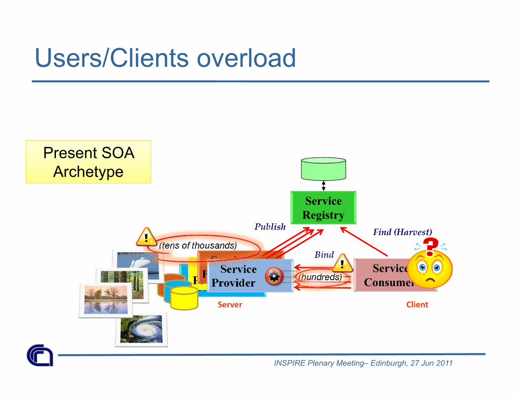
Users/Clients overload
(tens of thousands)
Service
Provider
Service
Provider
Service
ProviderService
Provider
Server
Service
RegistryPublish
Service
Consumer
Client
Find (Harvest)
Bind
Present SOA
Archetype
(hundreds)

INSPIRE Plenary Meeting– Edinburgh, 27 Jun 2011
Service
Consumer
Service
Provider
Service
Provider
Service
Provider
The Broker/Mediator component
Service
Provider
Server
Service
Consumer
Client
Service
RegistryPublish Find
Service
Broker(s) Mediator
Ha
rvest
(2-3)
(tens of thousands)
(hundreds)
A more
sustainable
approach
A Brokered-SOA proved to be
more sustainable
(i.e. flexible and scalable)
Tecnological &
Semantic mediation
and adaptations.
Quality control

INSPIRE Plenary Meeting– Edinburgh, 27 Jun 2011
Requirements for Multidisciplinary
Interoperability [EuroGEOSS, GEO-WOW]
• The EuroGEOSS recognized and discusses 15 main requirements for
enabling multidisciplinary interoperability
Req. DescriptionGR.1-3 Catalogues acts as brokers and support both distributed queries and harvestingGR.4 Catalogue(s) supports queries on location, time, SBA, keywordGR.5 Catalogue(s) supports discovery of data, services, and other resourcesGR.6 Support of interoperability shared practices (special interoperability arrangements)GR.7 Support for GeoRSSGR.8 Catalogue(s) supports ontology-based queriesGR.9 Support (Availability) of Transactional Data Access ServicesGR.10 Support (Availability) of OGC Web Processing ServiceGR.11 Creation of a GEOSS Data-COREGR.12 Resource discovery by “Data Access and Use Conditions”GR.13 Support semantic discovery (including GEOSS EO Observables Vocabulary)GR.14 Develop and deploy services and technologies for facilitating effective and seamless
multidisciplinary data accessGR.15 Support convergence on standards: in a first phase this also includes the development of
necessary mediation components to bridge the existing and heterogeneous community
standards


BACK-UP SLIDES

INSPIRE Plenary Meeting– Edinburgh, 27 Jun 2011
Introduction
• GEOSS (Global Earth Observation System of Systems)
– 10-Year Implementation Plan running from 2005 to 2015
– Better decision making on 9 Societal Benefit Areas by making existing Earth
Observations resources easily accessible
• INSPIRE Directive: establishing an Infrastructure for Spatial Information in the
European Community
– Legislative instrument for the purposes of Community environmental policies
– Builds upon National SDIs operated and maintained by European Member States
• GMES (Global Monitoring for Environment and Security)
– Joint initiative of the European Commission and European Space Agency
– 3 components: Space Component, In-Situ Component, Service component on Marine,
Atmosphere, Land, Emergency, Security at pre-operational stage