introduction - barron county, wisconsin - www ...55b35465-9825-4c7f... · web viewre/max realty...
TRANSCRIPT

Barron County Land Information PlanDecember 2015
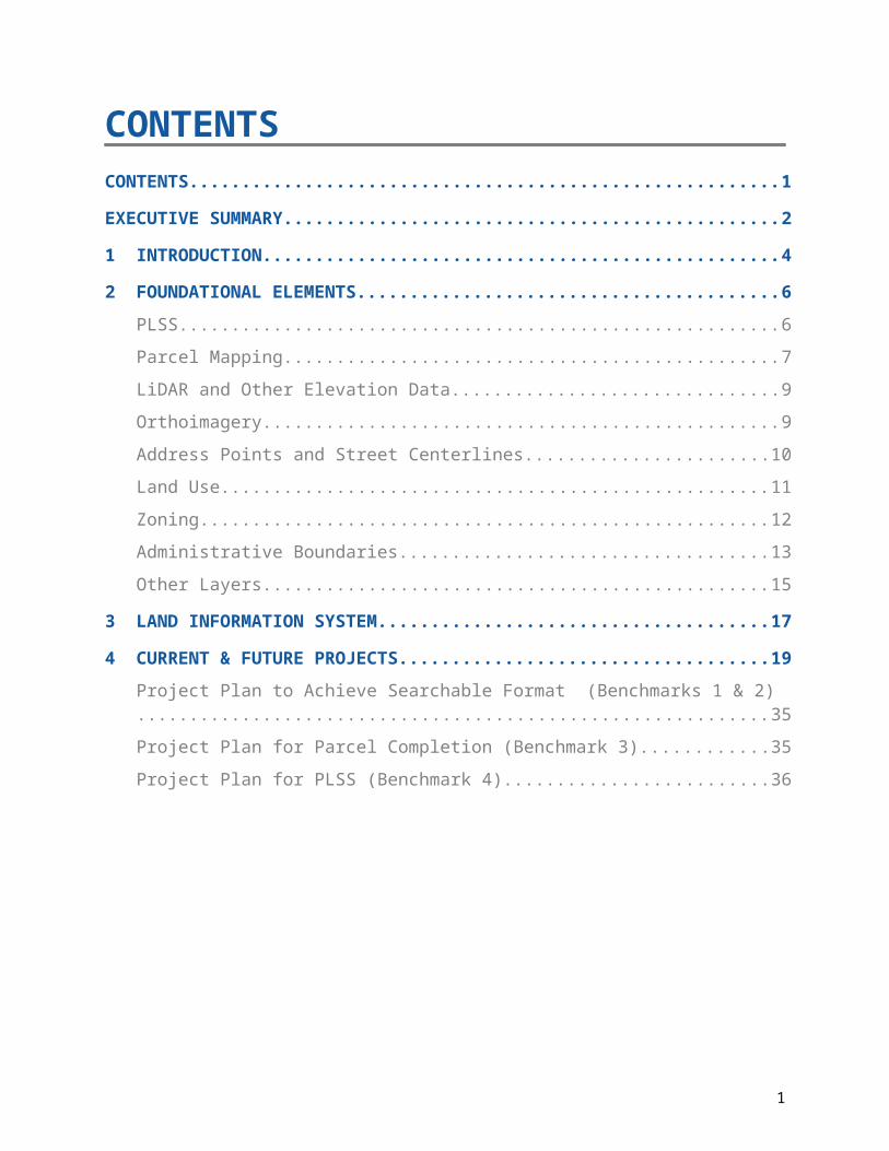
CONTENTSCONTENTS.......................................................................................................................1
EXECUTIVE SUMMARY...................................................................................................2
1 INTRODUCTION.........................................................................................................4
2 FOUNDATIONAL ELEMENTS...................................................................................6PLSS...........................................................................................................................6
Parcel Mapping...........................................................................................................7
LiDAR and Other Elevation Data................................................................................9
Orthoimagery..............................................................................................................9
Address Points and Street Centerlines.....................................................................10
Land Use...................................................................................................................11
Zoning.......................................................................................................................12
Administrative Boundaries........................................................................................13
Other Layers.............................................................................................................15
3 LAND INFORMATION SYSTEM..............................................................................17
4 CURRENT & FUTURE PROJECTS.........................................................................19Project Plan to Achieve Searchable Format (Benchmarks 1 & 2)............................35
Project Plan for Parcel Completion (Benchmark 3)...................................................35
Project Plan for PLSS (Benchmark 4).......................................................................36
1

EXECUTIVE SUMMARY
About this Document. This document is a land information plan for Barron County prepared by the land information officer (LIO) and the land information council. By Wisconsin statute, “a countywide plan for land records modernization” is required for participation in the Wisconsin Land Information Program (WLIP). The purpose of this document is twofold: 1) to meet WLIP funding eligibility requirements necessary for receiving grants and retaining fees for land information, and 2) to plan for county land records modernization in order to improve the efficiency of government and provide improved government services to businesses and county residents.
WLIP Background. The WLIP, administered by the Wisconsin Department of Administration, is funded by document recording fees collected by register of deeds at the county-level. In 2014, Barron County received $9,208 in WLIP grants and retained a total of $68,056 in local register of deeds document recording fees for land information. Beginning in 2016, WLIP Strategic Initiative grants are projected to increase the county land information budget by $50k per year.
This plan lays out how funds from grants and retained fees will be prioritized. However, as county budgets are determined on an annual basis with county board approval, this plan provides estimated figures that are subject to change and are designed to serve planning purposes only.
Land Information in Barron County. Land information is central to county operations, as many essential services rely on accurate and up-to-date geospatial data and land records. A countywide land information system supports economic development, emergency planning and response, and a host of other citizen services. The Barron County land information system integrates and enables efficient access to information that describes the physical characteristics of land as well as the property boundaries and rights attributable to landowners.
Mission of the Land Information Office. In the next three years, Barron County’s Land Information Office strives to complete and keep current all Foundational Elements and to continue to support, develop, and facilitate the following: its webmapping site, gains in governmental efficiencies by broadening the utilization of GIS, improvements in parcel mapping accuracy, and responsiveness to meeting the land records needs of residents and businesses.
Land Information Office Projects. To realize this mission, in the next three years, the county land information office will focus on the following projects:
1. Digitizing Zoning records
2. Connect tax/assessment web portal to GIS
3. GIS data storage
4. Register of Deeds back scanning
5. Rural address inventory
6. Historic orthoimagery
7. Updating hardware & software for fieldwork
8. Highway Department inventory software
9. Create impervious surface database in shoreline areas
10. Lakeside structure photos
11. LIDAR Survey
12. New orthophotography2

13. Update forest trail layer
14. Add EVAAL layer to GIS
The remainder of this document provides more details on Barron County and the WLIP, summarizes current and future land information projects, and reviews the county’s status in completion and maintenance of the WLIP map data layers known as Foundational Elements.
3

1 INTRODUCTIONIn 1989, a public funding mechanism was created whereby a portion of county Register of Deeds document recording fees collected from real estate transactions would be devoted to land information through a new program called the Wisconsin Land Information Program (WLIP). The purpose of the land information plan is to meet WLIP requirements and aid in county planning for land records modernization.
The WLIP and the Land Information Plan RequirementIn order to participate in the WLIP, counties must meet certain requirements:
Update the county’s land information plan at least every three years Meet with the county land information council to review expenditures,
policies, and priorities of the land information office at least once per year Report on expenditure activities each year Submit detailed applications for WLIP grants Complete the annual WLIP survey Subscribe to DOA’s land information listserv Meet a June 30, 2017 deadline to post certain types of parcel information
online
Any grants received and fees retained for land information through the WLIP must be used for projects which are consistent with the county land information plan.
Act 20 and the Statewide Parcel Map InitiativeA major development for the WLIP occurred in 2013 through the state budget bill, known as Act 20. It directed the Department of Administration (DOA) to create a statewide digital parcel map in coordination with counties.
Act 20 also provided more revenue for WLIP grants, specifically for the improvement of local parcel datasets. The WLIP is dedicated to helping counties meet the goals of Act 20 and has proposed that funding be made available to counties in the form of Strategic Initiative grants to be prioritized for the purposes of parcel dataset improvement. For Strategic Initiative grant eligibility, counties will be required to apply WLIP funding toward achieving certain statewide objectives, specified in the form of “benchmarks.” Benchmarks for parcel data—standards or achievement levels on data quality or completeness—are determined through a participatory planning process and will be detailed in future WLIP grant applications.
County land information plans were initially updated every five years. However, as a result of Act 20, counties must update and submit their plans to DOA for approval every three years. Thus, the minimum planning horizon for these documents is three years. The plan may incorporate a planning horizon that is longer if the needs and priorities of the participants warrant.
County Land Information System History and ContextSince the establishment of the Wisconsin Land Information Program in 1989, Barron County has completed or nearly completed all the Foundational Elements as shown later in this plan. Barron County continues to expand the amount and variety of land records data available via the internet. An internal GIS application is used by numerous county departments as well. The county Sheriff department dispatch center uses an integrated mapping system which is maintained by county staff. In addition to data created by the county, existing GIS data produced by the DNR, regional planning, and other entities is incorporated as available/desired. To date, data-sharing agreements have allowed the county to overcome any issues regarding exchange of GIS data. The County Technology Department has, and continues to, support efforts to share land records data among users and integrate new software and other information. End users, both internal and external, provide the county with feedback regarding timeliness and accuracy of the data. Data is constantly critiqued by users and improved as possible. Goals and objectives are periodically revised according to this feedback. Many county departments have embraced land records technology and rely on it daily, therefore providing personal incentive to maintain the relevancy of the data.
4
LAND INFORMATIONAny physical, legal, economic or environmental information or characteristics concerning land, water, groundwater, subsurface resources or air in this state.
‘Land information’ includes information relating to topography, soil, soil erosion, geology, minerals, vegetation, land cover, wildlife, associated natural resources, land ownership, land use, land use controls and restrictions, jurisdictional boundaries, tax assessment, land value, land survey records and references, geodetic control networks, aerial photographs, maps, planimetric data, remote sensing data, historic and prehistoric sites and economic projections.
– Wis. Stats. section 16.967(1)(b)

Plan Participants and Contact Information This plan was prepared by the county LIO, the Land Information Council, and others as listed below.
5
County Land Information Council and Plan Workgroup
Name Title Affiliation Email Phone*Mark Netterlund County Surveyor/Land
Information OfficerBarron County [email protected] 715-537-6824
*Vonnie Ritchie Treasurer Barron County [email protected] 715-537-6284
*Patricia Haas Real Property Lister Barron County [email protected] 715-537-6313
*Stanley Buchanan County Board Member Barron County [email protected] 715-243-6465
*Rhonda Sukys Land Information Office Representative
Barron County [email protected] 715-537-6827
*Jon Hile Realtor Re/Max Realty [email protected] 715-671-8270
*Barry Kuenkel Public Safety Officer Cumberland Fire Dept [email protected] 715-822-4352
*Margo Katterhagen Register of Deeds Barron County [email protected] 715-537-6213
*David Gifford Land Services Director Barron County [email protected] 715-537-6378
*Jeff French County Administrator Barron County [email protected] 715-537-6840
Kim Russell-Collins Administrative Specialist Barron County [email protected] 715-537-6375
* Land Information Council Members designated by asterisk
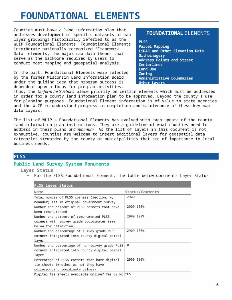
2 FOUNDATIONAL ELEMENTSCounties must have a land information plan that addresses development of specific datasets or map layer groupings historically referred to as the WLIP Foundational Elements. Foundational Elements incorporate nationally-recognized “Framework Data” elements, the major map data themes that serve as the backbone required by users to conduct most mapping and geospatial analysis.
In the past, Foundational Elements were selected by the former Wisconsin Land Information Board under the guiding idea that program success is dependent upon a focus for program activities. Thus, the Uniform Instructions place priority on certain elements which must be addressed in order for a county land information plan to be approved. Beyond the county’s use for planning purposes, Foundational Element information is of value to state agencies and the WLIP to understand progress in completion and maintenance of these key map data layers.
The list of WLIP’s Foundational Elements has evolved with each update of the county land information plan instructions. They are a guideline of what counties need to address in their plans at a minimum. As the list of layers in this document is not exhaustive, counties are welcome to insert additional layers for geospatial data categories stewarded by the county or municipalities that are of importance to local business needs.
PLSS Public Land Survey System MonumentsLayer Status
For the PLSS Foundational Element, the table below documents Layer Status
PLSS Layer Status
Name Status/CommentsTotal number of PLSS corners (section, ¼, meander) set in original government survey
2909
Number and percent of PLSS corners that have been remonumented 2909 100%
Number and percent of remonumented PLSS corners with survey grade coordinates (see below for definition)
2909 100%
Number and percentage of survey grade PLSS corners integrated into county digital parcel layer
2909 100%
Number and percentage of non-survey grade PLSS corners integrated into county digital parcel layer
0
Percentage of PLSS corners that have digital tie sheets (whether or not they have corresponding coordinate values)
2909 100%
Digital tie sheets available online? Yes or No YES
Approximate number of PLSS corners believed to physically exist based on filed tie-sheets or surveys, but do not have coordinate values
0
Approximate number of PLSS corners believed to be lost or obliterated
0
Total number of PLSS corners along each bordering county 243
Number and percent of PLSS corners remonumented along each county boundary
243 100%
Number and percent of remonumented PLSS corners along each county boundary with survey grade coordinates
243 100%
Does your county collaborate with or plan to collaborate with YES
6
FOUNDATIONAL ELEMENTSPLSSParcel MappingLiDAR and Other Elevation DataOrthoimageryAddress Points and Street CenterlinesLand UseZoningAdministrative BoundariesOther Layers
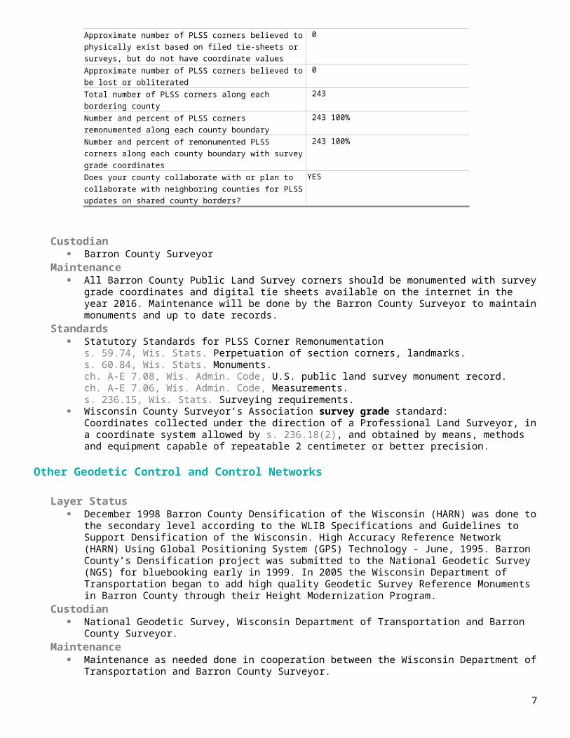
neighboring counties for PLSS updates on shared county borders?
Custodian Barron County Surveyor
Maintenance All Barron County Public Land Survey corners should be monumented with survey grade coordinates and digital
tie sheets available on the internet in the year 2016. Maintenance will be done by the Barron County Surveyor to maintain monuments and up to date records.
Standards Statutory Standards for PLSS Corner Remonumentation
s. 59.74, Wis. Stats. Perpetuation of section corners, landmarks.s. 60.84, Wis. Stats. Monuments.ch. A-E 7.08, Wis. Admin. Code, U.S. public land survey monument record.ch. A-E 7.06, Wis. Admin. Code, Measurements.s. 236.15, Wis. Stats. Surveying requirements.
Wisconsin County Surveyor’s Association survey grade standard:Coordinates collected under the direction of a Professional Land Surveyor, in a coordinate system allowed by s. 236.18(2), and obtained by means, methods and equipment capable of repeatable 2 centimeter or better precision.
Other Geodetic Control and Control Networks
Layer Status December 1998 Barron County Densification of the Wisconsin (HARN) was done to the secondary level according
to the WLIB Specifications and Guidelines to Support Densification of the Wisconsin. High Accuracy Reference Network (HARN) Using Global Positioning System (GPS) Technology - June, 1995. Barron County’s Densification project was submitted to the National Geodetic Survey (NGS) for bluebooking early in 1999. In 2005 the Wisconsin Department of Transportation began to add high quality Geodetic Survey Reference Monuments in Barron County through their Height Modernization Program.
Custodian National Geodetic Survey, Wisconsin Department of Transportation and Barron County Surveyor.
Maintenance Maintenance as needed done in cooperation between the Wisconsin Department of Transportation and Barron
County Surveyor. Standards
National Geodetic Survey and Wisconsin Department of Transportation.
Parcel MappingParcel GeometriesLayer Status
Complete. 100% of parcel data available in ESRI geodatabase and/or shapefile format. Coordinate system: Barron County WISCRS NAD83(2011) (Wisconsin Coordinate Reference System). Parcel polygons may be directly integrated with tax/assessment data via a parcel number attribute. Barron County does not use or plan to implement the Esri Parcel Fabric Data Model and/or Esri’s Local
Government Information Model.Custodian
Barron County Land Information Office.Maintenance
Daily, as necessary.Standards and Documentation
Data DictionaryFile layouts for assessment/tax database extracts are available.
7

Assessment/Tax Roll DataLayer Status
GCS Software, Inc Property Assessment and Taxation System software is used by Barron County to prepare assessment and tax roll data and tax bills. No outside vendor assistance is utilized.
Custodian Barron County Real Property Lister.
Maintenance Daily, as necessary.
Standards s. 73.03(2a), Wis. Stats. Department of Revenue (DOR) – Powers and duties defined.
Department of Revenue Property Assessment Manual – Chapter 5 and DOR format standard requested by DOR for assessment/tax roll data
s. 59.72(2)(a), Wis. Stats. Presence of all nine “Act 20” attributes (zoning data stored separately) s. 59.72(2)(a), Wis. Stats. Crosswalk of attributes
Act 20 Attributes Required by s. 59.72(2)(a)
Field Name(s) in County Land Info System
Notes on Data or Exceptions to DOR Standard
Assessed value of land LandValueAssessed value of improvements ImprovementValue
Total assessed value TotalValue
Class of property, as specified in s. 70.32 (2)(a) Class/Code
Estimated fair market value FairMarketValue
Total property taxGross/NetPropertyTaxDue
Any zoning information maintained by the county N/A Zoning information is not required in DOR schema
Any property address information maintained by the county PropertyAddress
Any acreage information maintained by the county Acres
Non-Assessment/Tax Information Tied to Parcelse.g., permits, easements, non-metallic mining, brownfields, restrictive covenants
Layer Status N/A
Custodian
Maintenance
Standards
ROD Real Estate Document Indexing and ImagingStatus
Grantor/Grantee Index. Complete. Paper-based indexing ceased in 1999 with conversion to digital indexing. Digital conversion and indexing of older documents is ongoing. Fidlar Software utilized for searching, indexing and retrieval.
8
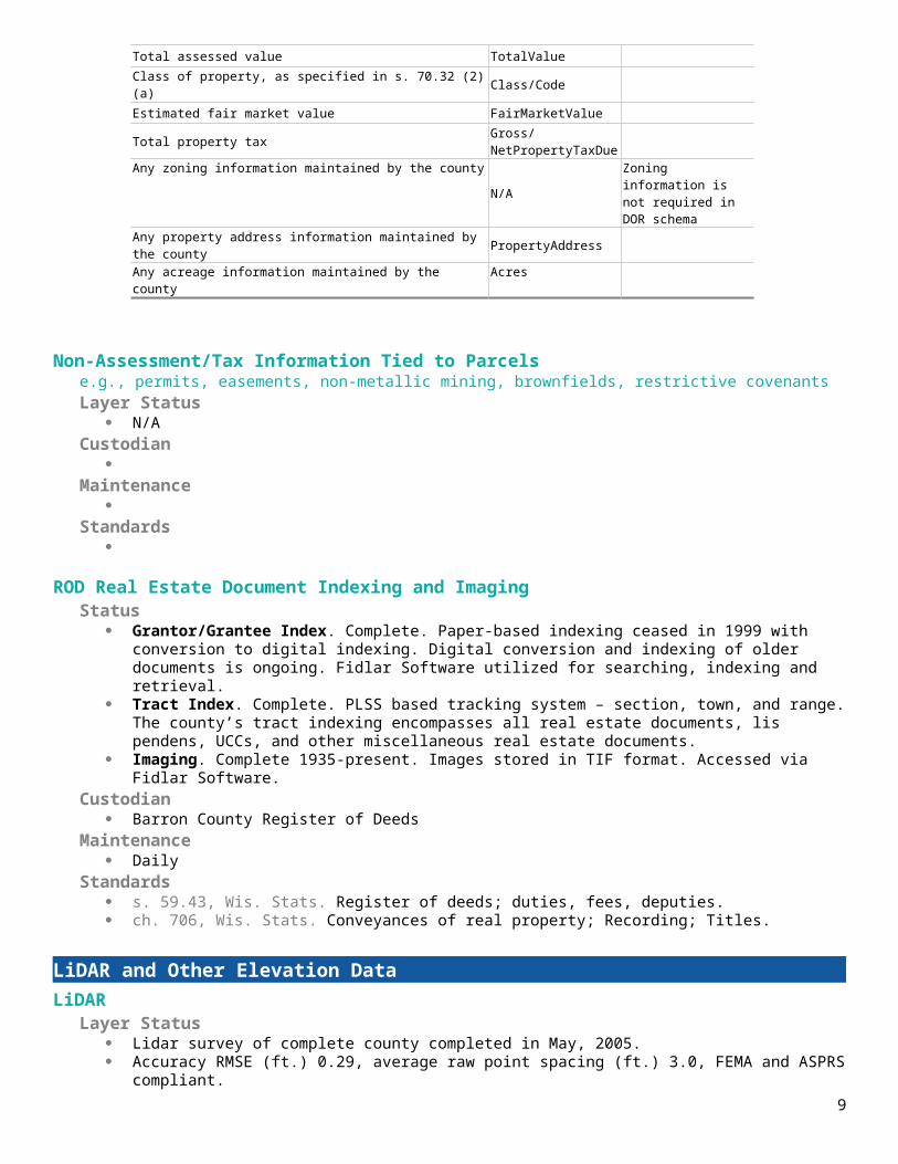
Tract Index. Complete. PLSS based tracking system – section, town, and range. The county’s tract indexing encompasses all real estate documents, lis pendens, UCCs, and other miscellaneous real estate documents.
Imaging. Complete 1935-present. Images stored in TIF format. Accessed via Fidlar Software.Custodian
Barron County Register of DeedsMaintenance
DailyStandards
s. 59.43, Wis. Stats. Register of deeds; duties, fees, deputies. ch. 706, Wis. Stats. Conveyances of real property; Recording; Titles.
LiDAR and Other Elevation DataLiDARLayer Status
Lidar survey of complete county completed in May, 2005. Accuracy RMSE (ft.) 0.29, average raw point spacing (ft.) 3.0, FEMA and ASPRS compliant.
Custodian Barron County Land Information.
Maintenance As need and funds allow.
Standards FEMA and ASPRS compliant.
LiDAR Derivatives
Layer Status Digital Terrain Model, Digital Elevation Model and 2’ contours.
Custodian Barron County Land Information.
Maintenance As need and funds allow.
Standards FEMA and ASPRS compliant.
Other Types of Elevation Data Layer Status
N/A Custodian
Maintenance
Standards
OrthoimageryOrthoimageryLayer Status
Complete, 2015. High Resolution (6” pixel), color. Participated in WROC 2015 Next planned flight 2018+/-.
Custodian Barron County Land Information.
9

Maintenance Updated every 3-4 years +/-.
Standards ASPRS 1”=100’ Class 2 RMSE 2.0’+/-.
Historic OrthoimageryLayer Status
High Resolution (6” pixel) color: 2012 and 2008; black and white: 2005.Custodian
Barron County Land InformationMaintenance
N/A.Standards
National Map Accuracy Standards for 1”=100’.
Other Types of Imagery e.g., oblique, infra-red, etc.
Layer Status Paper/mylar maps: 1939, 1951, 1961 and 1979.
Custodian Barron County Soil & Water Conservation Department.
Maintenance N/A.
Standards N/A.
Address Points and Street CenterlinesAddress Point Data Layer Status
Complete; needs verification. Building point address layer has been developed. Points are located on main structure where determinable.
Site addresses are stored in Property Assessment and Taxation System. Rural address assignment information is stored in a shared Access database. Original address assignment (911 implementation) maps scanned. Current address maps available via County website. Rural addresses assigned by Barron County Zoning Department.
Custodian Barron County Land Information, Real Property Lister, Zoning Department, city/village officials.
Maintenance Daily, as necessary.
Standards Barron County Ordinance 1-95: Uniform system of street identification and property numbering.
Building FootprintsLayer Status
None available. Future possible shoreland planimetrics to determine impervious surface.Custodian
Maintenance
Standards
10

Other Types of Address Informatione.g., address ranges
Layer Status Address ranges, complete; stored in MSAG (Access database) and also present in road centerline shapefile.
Custodian Barron County Land Information, Sheriff’s Department.
Maintenance Daily, as necessary.
Standards Layer attributes created to integrate with Sheriff’s Department dispatch mapping software system. MSAG format determined by 911 communications provider. Barron County Ordinance 1-95: Uniform system of street identification and property numbering.
Street CenterlinesLayer Status
Complete. Custodian
Barron County Land Information, Zoning Department.Maintenance
Daily, as necessary. Standards
Layer attributes created to integrate with Sheriff’s Department dispatch mapping software system. Barron County Ordinance 1-95: Uniform system of street identification and property numbering.
Rights of WayLayer Status
Complete. Highway plans scanned and indexed. Available via GIS website survey document search. Transportation Plats recorded at Register of Deeds office
Custodian Barron County Land information, Highway Department, Register of Deeds.
Maintenance Daily, as necessary.
Standards N/A.
Trailse.g., recreational trails
Layer Status Complete: ATV, biking, skiing, hiking, forest trails, snowmobile.
Custodian Barron County Land Information, Sheriff’s Department, Parks & Recreation, Forestry.
Maintenance Daily, as necessary.
Standards N/A.
Land UseCurrent Land UseLayer Status
N/A. None created by county. May utilize state-produced land cover data.Custodian
11
Maintenance
Standards
Future Land UseLayer Status
Completed in 2010 for Barron County Comprehensive Plan.Custodian
Barron County Zoning Department, Land Information.Maintenance
None anticipated.Standards
s. 66.1001, Wis. Stats. Comprehensive planning.Future land use map was created through Barron County’s comprehensive planning process. Future land use mapping for Barron County is a compilation and standardization of comprehensive plans adopted by municipalities and the county.
ZoningCounty General Zoning Layer Status
Complete for unincorporated areas administered by the Barron County Zoning Department. Digital representation of official (paper) zoning district map.
Custodian Barron County Zoning Department, Land Information.
Maintenance Monthly, as necessary.
Standards Will include s. 59.72(2)(a), Wis. Stats “Act 20” attributes Barron County Land Use Ordinance.
County Special Purpose Zoning e.g., shoreland, farmland preservation, floodplain, and airport protection
Layer Status Shoreland zoning area, complete. Farmland preservation plan area, complete. Airport height limitation zoning, complete. Dam hydraulic shadow area, in progress. Designated freeway conversion area, complete. FEMA floodplain, complete, 2009-2010. Custody of FEMA.
Custodian Barron County Land Information, Zoning Department (except floodplain).
Maintenance As necessary.
Standards Barron County Land Use Ordinance. Chapter NR115 Wisconsin’s Shoreland Protection Program Chapter 91 Farmland Preservation FEMA standards
Municipal Zoning Information Maintained by the Countye.g., town, city and village, shoreland, floodplain, airport protection, extra-territorial, temporary zoning for annexed territory, and/or zoning pursuant to a cooperative plan
Layer Status Extraterritorial zoning area, complete.
12
Extraterritorial subdivision area, complete.Custodian
Barron County Land Information, Zoning Department.Maintenance
As necessary; annexations.Standards
s. 62.23(7a), Wis. Stats Extraterritorial Zoning
Administrative BoundariesCivil Division Boundaries
e.g., towns, city, villages, etc.Layer Status
Complete. Custodian
Barron County Land Information.Maintenance
As necessary; annexations or detachments.Standards
N/A.
School DistrictsLayer Status
Complete. School district code contained in assessment database extract, joined with parcel polygons via parcel number
attribute. Custodian
Barron County Land Information, Real Property Lister.Maintenance
None anticipated; as necessary.Standards
School district codes determined by state.
Election Boundariese.g., voting districts, precincts, wards, voting places, etc.
Layer Status County Supervisory districts, complete. Wards, complete. State districts (Assembly/Senate), complete. Aldermanic districts, complete. Polling places, complete.
Custodian Barron County Land Information, County Clerk.
Maintenance As necessary; annexations, redistricting.
Standards Layer attributes created to integrate with Statewide Voter Registration System and for C-BAS participation.
Utility Districtse.g., water, sanitary, electric, etc.
Layer Status Rural sanitary districts available. Layer(s) can be created via query of district codes from assessment database
extract and join with parcel polygons via parcel number attribute. Custodian
Barron County Land Information, Real Property Lister, municipal officials.
13

Maintenance None anticipated; as necessary.
Standards N/A.
Public Safetye.g., fire/police districts, emergency service districts, 911 call center service areas, healthcare facilities
Layer Status Emergency service zone, complete. Fire district, complete. Ambulance district, complete. First Responder area, complete. JAWs area, complete. Responder locations, complete. DNR fire response area, complete. Medical facility locations, complete. Emergency siren locations, complete. All layers countywide; 911 call center area is entire county.
Custodian Barron County Emergency Management, Sheriff’s Department, Land Information.
Maintenance As necessary.
Standards Layer attributes created to integrate with Sheriff’s Department dispatch mapping software system.
Lake DistrictsLayer Status
Lake districts, complete. Standalone GIS layer as well as ability to create via query of district codes from assessment database extract and join with parcel polygons via parcel number attribute.
Custodian Barron County Land Information, Real Property Lister, Soil & Water Conservation, municipal officials, district
officials.Maintenance
As necessary.Standards
N/A.
Native American LandsLayer Status
Complete. Standalone layer for Maple Plain Reservation. Also available via query of Federal Lands (assessment code X1) from assessment database extract and join with parcel polygons via parcel number attribute.
Custodian Barron County Land Information, Real Property Lister, municipal assessor.
Maintenance As necessary.
Standards Department of Revenue Property Assessment Manual – Chapter 5 and DOR format standard requested by DOR
for assessment/tax roll data
Other Administrative Districtse.g., county forest land, parks, etc.
Layer Status County forest compartments, complete. County forest stands, complete.
14

County forest trails & gates, complete. Compartment trail maps available via county website. Parks, complete.
Custodian Barron County Land Information, Parks & Recreation, Forestry.
Maintenance As necessary.
Standards Barron County Forest Ordinance, Forest Comprehensive Land Use Plan
Other LayersHydrography Maintained by County or Value-Added
e.g., hydrography maintained separately from DNR or value-added, such as adjusted to orthosLayer Status
Surface water, complete. Originally from 2005 orthophotos; attributes added, layer edited to include hydro within shoreland zoning jurisdiction.
Custodian Barron County Land Information.
Maintenance None anticipated.
Standards N/A.
Cell Phone TowersLayer Status
Complete for areas administered by Barron County Zoning Department.Custodian
Barron County Land Information, Zoning Department.Maintenance
As necessary.Standards
N/A.
Bridges and CulvertsLayer Status
Bridges, complete. Currently no culvert data.
Custodian Barron County Land Information, Highway Department.
Maintenance As necessary.
Standards Numbering determined Wisconsin Department of Transportation.
Othere.g., pipelines, railroads, non-metallic mining, sinkholes, manure storage facilities, etc.
Layer Status Railroads, complete. Non-metallic mining permitted areas, complete. Manure storage facilities, complete. Airports, complete. Cemetery, complete. Church, complete.
Custodian Barron County Land Information, Zoning Department, Soil & Water Conservation Department.
15

Maintenance As necessary.
Standards Chapter NR135 Nonmetallic Mining Reclamation Barron County Chapter 18 Animal Manure Storage Facilities
16

3 LAND INFORMATION SYSTEMThe WLIP seeks to enable land information systems that are both modernized and integrated. Integration entails the coordination of land records to ensure that land information can be shared, distributed, and used within and between government at all levels, the private sector, and citizens.
One integration requirement is listed under s. 16.967(7)(a)(1), Wis. Stats., which states that counties may apply for grants for:
The design, development, and implementation of a land information system that contains and integrates, at a minimum, property and ownership records with boundary information,including a parcel identifier referenced to the U.S. public land survey; tax and assessment information; soil surveys, if available; wetlands identified by the department of natural resources; a modern geodetic reference system; current zoning restrictions; and restrictive covenants.
This chapter describes the design of the county land information system, with focus on how data related to land features and data describing land rights are integrated and made publicly available.
County Parcel Data Workflow Diagram
17
LAND INFORMATION SYSTEMAn orderly method of organizing and managing land information and land records
– Wis. Stats. section 16.967(1)(c)

18
Figure 1. Barron County Parcel + Tax Roll + Zoning Workflow
DOAAssembles
Statewide Parcel Layer from Data
Tax Bills
Treasurer
Imports 1st installment payments from municipalities to tax system
Collects 2nd installments & delinquent taxes
Calculates tax settlements Send settlement reports/payments
to state & taxing districts Updates lottery credit & mailing
addresses Tax deed process; sell parcels; record
tax deeds GCS software utilized GCS web portal available to public
(real-time data)
Zoning Administrator
Review land divisions; record approved CSMs
Review rezoning requests
Issue land use permits; provide to municipality and assessor
Permis on web portal GCS software utilized
Real Property Lister
Maintain parcel ownership records
Coordinate assessment process Review proposed land divisions. Process land divisions by
creating new parcels in tax database
Coordinate tax calculations and print tax bills
GCS software utilized
Surveyor
Review land divisions (CSMs)
Maintain PLSS and other geodetic control
Survey county property Maintain catalog of
survey documents for county
GIS Specialist/Land Info Technician
Maintain parcel geometries; integrate land divisions and new survey data
Maintain county zoning GIS layer
Provide mapping updates to GIS website vendor
Submit parcel polygons, tax roll data, and zoning information to DOA
ESRI ArcMap 10.3.1 utilized
Public
Propose land divisions Propose rezonings Order survey maps of
property Record land division
documents Pays taxes Requests
assessment/tax info Views tax bills online
Register of Deeds
Records real estate docs Process real estate transfer
returns Index/scan documents into
Fidlar software
Municipalities/Local Assessors
Receive work roll & land divisions from county
Update property values & provide to county
Certify assessed values and tax levies Receive tax bills/files from county Collects & exports 1st installment tax
payments to county Approve land divisions (selected munic) Record land-related documents
(annexations, vacations, etc)
State
DOR – Provide manufacturing assessment, equalized assessment values, property tax credits. Receive Statement of Assessment from countyReceive tax settlement reports & payments from county
DNR – Managed Forest Lands Values

Technology Architecture and Database Design
Metadata and Data Dictionary PracticesMetadata is generated via ArcCatalog using FGCD schema. Fields are not manually populated at this time. There are no office policies related to metadata.
Municipal Data Integration ProcessNo GIS datasets are integrated into the county system. Municipal assessment and tax data are integrated via imports into the GCS Property Assessment and Tax database. The county is notified of city and village address changes/additions and updates are made by county staff.
Public Access and Website Information
Type of WebsiteSoftware or App
3rd Party or Contractor URL
Update Frequency/ Cycle
GIS webmapping site Wgxtreme Applied Data Consultants
http://barroncowi.wgxtreme or link at http://www.barroncountywi.gov
Monthly
ROD TapestryLaredo
FidlarFidlar
http://www.landrecords.nethttp://www.fidlar.com
Daily
Treasurer/RPL Land Records Web Portal GCS http://www.co.barron.wi.us/gcsWebPortal/search.aspxl
Daily
Zoning Wgxtreme Applied Data Consultants
http://barroncowi.wgxtreme or link at http://www.barroncountywi.gov
Monthly
Survey Documents including PLSS tie sheets
Wgxtreme Applied Data Consultants
http://barroncowi.wgxtreme or link at http://www.barroncountywi.gov
Daily
Data Sharing
Data Availability to PublicData is available to the public on the above county websites. There is no fee for viewing data on the county websites except for the Register of Deeds website. Specific GIS data sets are available on CD/DVD or by ftp for a fee. Barron County complies with Wisconsin’s Open Records Law.
Data Sharing Restrictions Agencies entering into a data sharing agreement with Barron County agree to not release/sell such data to third parties. No other restrictions.
Government-to-Government Data SharingBarron County has data sharing agreements with several governmental agencies and non-profit corporations. Barron County provides data to these governmental agencies and non-profit corporations at no cost. Currently 34 agencies have a data sharing agreements with Barron County.
Training and EducationCounty staff is available to discuss user needs and land information data queries in person, by phone, or email. Use of GIS website and county internal GIS program technical support available via county staff. GIS website training is available for county staff and local officials. Plan to continue using educational grant funds to improve staff skills for modernizing land records.
19

4 CURRENT & FUTURE PROJECTS
Project: Digitizing Zoning Records
Project Description/GoalAll permits and basic public hearing information will be scanned and indexed to parcel numbers. Parcel files are organized by Towns and scanning of unzoned Towns was completed first, starting in October of 2012. Zoned towns are being scanned in order, smallest to largest. All documents will be available via the GIS website for public access.
Business DriversIncrease efficiency of Zoning Department with scanned permitsPlumbers, septage haulers and landowners can access sanitary information more easily.Land use permits available to public.Basic hearing information available to the public.
Objectives/Measure of SuccessPermits/documents 100% scanned and available via the GIS website.
Project TimeframesProject to be completed in the year 2016-2017
Responsible Parties Barron County Zoning Office, LTE
Estimated Budget Information Limited Term Employee: 1560 hours X $16.00 = $24,960.
20

Connect Treasurer Web Portal to GIS Mapping
Project Description/GoalConnect parcel information on Treasurer Web Portal which is hosted by GCS Software to a map view on county GIS website hosted by Applied Data Consultants.
Business DriversIncrease value of website by linking to county map data.
Objectives/Measure of SuccessAttaching a current GIS map view to Treasurer parcel information.
Project TimeframesProject to be completed in the year 2016.
Responsible Parties Treasurer, Land Information Office, GCS Software and Applied Data Consultants GIS Service.
Estimated Budget Information $2000
21

GIS Data Storage
Project Description/GoalThe goal of the project is to provide highly reliable and redundant data storage for our Land Information data. Purchase and install a Dell Equallogic PS6100X storage area network (SAN).
Business DriversProvide reliable GIS dataSecure valuable GIS data
Objectives/Measure of SuccessObject is to maintain valuable data on a highly reliable storage system. Measure of success based on minimal unexpected data downtime.
Project TimeframesEarly in the year 2016.
Responsible Parties Barron County Technology Department.
Estimated Budget Information $25,000.
22

Register of Deeds Back Scanning
Project Description/GoalDocuments to be scanned, redact social security numbers and light indexed back to 1935. Documents will be available online.
Business DriversState of Wisconsin requests documents scanned, redacted, light indexed, and online back to 1935. With documents online, more efficiency for users.
Objectives/Measure of SuccessCurrently documents are scanned back to 1935; redacted back to 1964 and light indexed to 1994. With this project complete, all these would be completed back to 1935.
Project TimeframesProject partially done in year 2015.
Responsible Parties Register of Deeds with help from a Contractor.
Estimated Budget Information 158 volumes to Redact: $8,700354 volumes to Back Index using the Crowd Force process: $78,300Total $87,000
23
Project: Rural Address Inventory
Project Description/GoalVerify rural address locations by comparing addresses in the field with address layer.
Business DriversEmergency services providers, USPS, utility companies
Objectives/Measure of SuccessTo ensure rural property addresses are in the proper order to assist emergency service providers, U.S. Mail, utilities and the public.To ensure rural address signs are properly posted.Educate the public regarding the importance of rural addresses and sign placement.
Project TimeframesTBD
Responsible Parties Land Services Department, LTE
Estimated Budget Information Limited Term Employee: 1560 hours X $16.00 = $24,960.Educational component $2500
24

Historic Orthoimagery
Project Description/GoalCreate one or more Historic Orthoimagery layers to be added to the county GIS layers.
Business DriversAdding 1968 orthoimagery will allow County to assess extent of pre-existing structures, which is necessary for accurate permitting based on 2015 changes to Shoreland Zoning laws.Research of historical data would be more useful when it can be combined with current data in a GIS system. Land use planners, Zoning, Historians, Surveyors and more.
Objectives/Measure of SuccessFinal product received by county placed on county GIS website for use.
Project TimeframesTBD
Responsible Parties Land Information Office with the help of a contractor.
Estimated Budget Information Per Layer: $25,000 for contractorMore than one could be done.
25

Update Hardware & Software for Fieldwork
Project Description/GoalThe goal of the project is to upgrade and purchase tablets and needed software to assist employees in fieldwork, such as inspections, mining evaluation and conservation work
Business DriversImproved efficiency in the field through updated technology
Objectives/Measure of SuccessMaintain accurate and up to date inventory of Highway Dept. assets.
Project TimeframesEarly in the year 2016.
Responsible Parties Barron County Technology and Land Services Departments.
Estimated Budget Information $1400.
26

Highway Dept Inventory Software
Project Description/GoalThe goal of the project is to purchase software to maintain Highway Dept. assets such as signs, culverts and driveway locations
Business Drivers Provide reliable GIS data
Objectives/Measure of SuccessMaintain accurate and up to date inventory of Highway Dept. assets.
Project TimeframesTBD
Responsible Parties Barron County Technology and Highway Departments.
Estimated Budget Information $12,000.
27

Project: Create Impervious Surface Database
Project Description/GoalCreate a database of impervious surfaces on shoreline properties Countywide.
Business DriversIncrease efficiency of Zoning Department Adding impervious surface layer will allow County to assess properties, which is necessary for accurate permitting based on 2015 changes to Shoreland Zoning laws.
Objectives/Measure of SuccessAdd impervious surface layer to GIS website
Project TimeframesTBD
Responsible Parties Land Services Department, LTE
Estimated Budget Information $15,000
28

Project: Lakeside Structure Photos
Project Description/GoalPhotograph shoreline structures to create a geo-referenced database.
Business DriversIncrease efficiency of Zoning Department. Adding layer will allow County to evaluate properties, which is necessary for accurate permitting based on 2015 changes to Shoreland Zoning laws. Assist SWCD in indentifying areas of invasive species infestation.
Objectives/Measure of SuccessLayer added to GIS website
Project TimeframesTBD
Responsible Parties Land Services Department, LTE
Estimated Budget Information Limited Term Employee: 1560 hours X $16.00 = $24,960.
29
LIDAR Survey
Project Description/Goal Lidar Survey flown and create a Digital Terrain Model and contours.
Business DriversLidar data is used by many government and private agencies. Barron County had a Lidar Survey completed in 2005. Some terrain has changed since then due to construction projects, mining and erosion. The U.S. Geological Survey considers Lidar data 10+ years old in need to be updated. There may be a possibility to have a cost share on this project with the U.S. Geological Survey.
Objectives/Measure of SuccessLidar Survey, Digital Terrain Model and contours completed and added to the county GIS system.
Project TimeframesTBD
Responsible Parties Land Information Office with the help of a contractor.
Estimated Budget Information Total county wide project: $250,000 May find cost sharing partners for this project such as U.S. Geological Survey.
30

New Orthophotography
Project Description/GoalAcquire new 6” resolution color digital orthophotography.
Business DriversKeep orthophotography current on county website for business, public and governmental use. Share with other government agencies.
Objectives/Measure of SuccessFinal product received by county meeting ASPRS Class II standards and placed on county GIS website for use.
Project TimeframesFlown spring of 2017 or 2018, receive final deliverables summer 2017-18.
Responsible Parties Land Information Office with the help of a contractor.
Estimated Budget Information Contractor expense: $90,000
31

Project: Update Forest Trail Layer
Project Description/GoalGPS New county forest trails and add to GIS layers
Business DriversBenefit public and emergency service providers by providing more accurate location information.
Objectives/Measure of SuccessUpdated trails added to GIS layer
Project TimeframesTBD
Responsible Parties Land Services Department, LTE
Estimated Budget Information Limited Term Employee: 200 hours X $16.00 = $3200.
32

Project: EVAAL
Project Description/GoalPartner with Wisconsin DNR to create an Erosion Vulnerability Assessment of Agricultural Lands layer for the GIS website.
Business DriversIncrease efficiency of Soil & Water Conservation division in their quest to assist landowners with conservation projects.
Objectives/Measure of SuccessLayer available on GIS website
Project TimeframesTBD
Responsible Parties County Conservationist, WDNR
Estimated Budget Information $3000
33

Proposed Land Information Projects Estimated Budget Information
Project Item Unit Cost Cost Total Project Cost1. Digitizing Zoning records a. LTE 1560 hrs x $16/ph 24,960 $24,960
2. Connect Treasurer web portal to GIS
a. ADC/GCS $2000 2,000 $2000
3. GIS Data Storage a. BC Tech Dept $25,000 25,000 $25,000
4. ROD Scanning a. Redact 158 volumes $8700 8700 $8700
b. Back index 354 volumes
$78,300 78,300 $78,300
Sub-Total $87,000
5. Rural Address Inventory a. LTE 1560 hrs x $16/ph 24,960 $24,960
b. Educational campaign
$2500 $2500 $2500
Sub-Total $27,460
6. Historic Orthoimagery a. Outside vendor $25,000 25,000 $25,000
7. Update hardware/software for fieldwork
a. BC Tech $1400 1400 $1400
8. Software for Highway inventory of structural assets
a. Outside vendor $12,000 12,000 $12,000
9. Impervious surface database a. Outside vendor $15,000 15,000 $15,000
10. Lakeside structure photo database
a. LTE 1560 hrs x $16/ph 24,960 $24,960
11. LIDAR Survey a. Outside vendor $250,000 250,000 $250,000
12. Orthophotography a. Outside vendor $90,000 90,000 $90,000
13. Update Forest Trail Layer a. LTE 200 hrs x $16/ph 3200 $3200
14. EVAAL a. WDNR $3000 3,000 $3000
GRAND TOTAL $590,980
Note. These estimates are provided for planning purposes only. Budget is subject to change.
34

Project Plan to Achieve Searchable Format (Benchmarks 1 & 2)Project Description/GoalHow searchable format will be met
Barron County plans to meet the searchable format for both Benchmark 1 and 2 by March 31, 2016. We have approached the property assessment/tax software company to develop an extract with the required schema. Alternately, county staff will populate tables using existing extracts.
Business DriversThe Project Plan to Achieve Searchable Format for Benchmarks 1 & 2 is a requirement for Strategic Initiative grant eligibility.
Objectives/Measure of SuccessThe objective is to meet the searchable format for Benchmarks 1 & 2 (Parcel and Zoning Data Submission, Extended Parcel Attribute Set Submission) by March 31, 2016.
Project TimeframesEnd date 3/31/16.
Responsible Parties Land Services and Technology department staff.
Estimated Budget Information N/A. Have not been notified of any expected charges from software company. County staff time accounted for in existing budgets.
Project Plan for Parcel Completion (Benchmark 3)Project Description/Goal
Current status of parcel data Parcel data in the Barron County is 100% complete.
Goals Maintain current parcel mapping.
Planned approach Update parcel mapping as land divisions occur.
Business DriversThe Project Plan for Parcel Completion is a requirement for Strategic Initiative grant eligibility.
Current parcel mapping should be available for county staff, municipalities, the public, real estate professionals, and any other users of this data.
Objectives/Measure of SuccessThe objective is to meet Benchmark 3 (Completion of County Parcel Fabric) by March 31, 2016.
Project TimeframesThis project will be complete as of the March 31, 2016 submittal to the state. Parcel data is maintained current.
Responsible Parties GIS Specialist, Land Info Technician, Real Property Lister.
35

Estimated Budget Information N/A. County staff time accounted for in existing budgets.
Project Plan for PLSS (Benchmark 4)Project Description/Goal
Planned approach County Surveyor has restored, monumented, established survey-grade coordinates and placed
digital tie sheet on line for all PLSS corners effective 4/8/2016. Current status
There are 2909 PLSS corners in Barron County. All these corners have Survey-Grade coordinates. Survey-grade – Coordinates collected under the direction of a professional land surveyor,
in a coordinate system allowed by s. 236.18(2), and obtained by means, methods and equipment capable of repeatable 2 centimeter or better precision
Goals Continue corner maintenance to ensure corner monuments in place.
Missing corner notes N/A
County boundary collaboration County line PLSS corner information is shared with 8 adjoining counties. Restoration projects on
county line have been done jointly with adjoining county.
Business DriversThe Project Plan for PLSS is a requirement for Strategic Initiative grant eligibility. Used as a base layer for county mapping creating more accurate GIS System.Accurately maintain true corner location.
Objectives/Measure of SuccessThe objective is to meet Benchmark 4 (Completion and Integration of PLSS) completed April 8, 2016.
Project TimeframesCompleted April 8, 2016.
Responsible Parties County Surveyor.
Estimated Budget Information N/A. County staff time accounted for in existing budgets.
12/11/20152/10/20164/8/2016
36