introduction - measure
TRANSCRIPT

IM AGE GOES HERE
THE BUSINES S C A SE FOR
Drones in Energy Operations
01MEASURE.COM
A ME A SUR E W HITE PA PER FOR ENTER PR ISE
Drones for Wind Turbine InspectionsHow to use drones to reduce hazardous man-hours and optimize energy production in wind farm operations.

02MEASURE.COM
A Measure White Paper Drones for Wind Turbine Inspections
The commercial adoption of drones is growing quickly, and the wind industry is no exception. Drones provide a practical solution for the inspection of wind turbines, as well as associated infrastructure such as feeder poles, collector lines, and electrical substations. Drones support business efforts to avoid hazardous man-hours; reduce costs for maintenance, inspections, and repairs; and minimize downtime.
Measure’s vast experience using drones includes providing actionable inspection data on 5000 MW of turbines in the US, Canada, and Puerto Rico; covering blades from leading OEMs including GE, Vestas, Siemens, Mitsubishi, and others. Measure has conducted inspections for a variety of asset managers, including Pattern Energy and BP. Measure has also trained hundreds of pilots on how to safely operate drones around energy infrastructure.
Drones offer not only cost and operational efficiencies for business, but also a great opportunity for workforce development. Operating drones around energy infrastructure is a highly skilled job, and Measure believes strongly in in-depth training and real-world experience. The safety standards followed by our pilots and our principles for conducting flights in a safe, legal, and efficient manner is one of the many reasons why power companies select us as their preferred drone services vendor.
There are also opportunities for experts in advanced data analytics, drone engineering, and in burgeoning areas such as AI and Machine Learning. Looking into the future, well beyond the scope of this paper, drones will operate fully autonomously, with no pilot in sight. Federal regulations, such as restrictions on flying drones beyond the visual line of sight (BVLOS), currently limit these types of operations, but those technologies are being developed today. The use of drones will continue to advance; you can get started by incorporating drones into your operations and taking advantage of the many cost, safety, and efficiency benefits available to you today.
Introduction

03MEASURE.COM
A Measure White Paper Drones for Wind Turbine Inspections
01 The Benefits of Drones 04
02 Data Collection - How It Works 07
03 Data Analysis & Delivery 10
04 Drone Program Basics 14
00 Appendix
A. Insource vs. Outsource Decision Guide 21
B. Components of an Air Operations Manual 22
C. Common Commercial Drone Platform 24
D. Measure Ground Control Overview 25
TA BLE OF CONTENT S

The Benefits of DronesHow Can Drones Optimize Wind Farm Operations?
04MEASURE.COM
A Measure White Paper Drones for Wind Turbine Inspections
THE BENEFIT S OF DRONES01

05MEASURE.COM
A Measure White Paper Drones for Wind Turbine Inspections
Drones provide safe, efficient inspections and data collection for businesses across the energy industry. Trained pilots and experienced data analysts use drone technology to drastically reduce inspection time, save labor costs and reduce hazardous man-hours, while providing higher quality data that enables companies to maximize energy production.
Using drones for wind turbine inspections both opens up new possibilities and replaces existing work. Without drones, inspections are typically completed manually by climbing or using long-range photography. Clearly, manual inspections involving climbing introduce hazards that are avoided with drones. Ground-based data collection can be slow and typically lacks the detail and flexibility that a drone can provide.
Due to the many benefits, using drones for turbine inspections is becoming more and more common. Let’s take a closer look at how drones can help optimize your wind farm.
Better Data
Drones can capture high-resolution imagery, which can be processed and analyzed to provide actionable inspection results. While capturing one-off images can certainly be useful (to investigate the effect of a lightning strike, for example), larger scale inspections of wind farms is where drone data really shines.
Drone data is detailed. Drones can deliver clear, precise imagery of the entire blade, with up to 40 mega pixels for ultra-high resolution. When using technologies like LiDAR, you can also get detailed measurements of any defects.
Drone data is analyzed. Data passes through automated processing and classification, followed by a manual data quality check and an expert engineering review of the most significant issues detected. This three-step process ensures that all defects have been properly identified, classified, and annotated so they are ready to inform your maintenance and repair decisions.
Drone data is easy to use. Analyzed drone data is uploaded to an online portal, which allows managers to view defects and sort data (by severity level, for example) to meet their needs. A pdf report of defects can be produced at the touch of a button.
Drone data is organized and stored. Once your inspection data is uploaded to the portal, it will be stored securely and available for future reference. Track changes over time or compare across multiple sites.
THE BENEFIT S OF DRONES01
Drone imagery showing transverse crack

06MEASURE.COM
A Measure White Paper Drones for Wind Turbine Inspections
Improved Operations
The more detailed and accurate data delivered by a drone inspection can enable companies to proactively identify more defects, which could lead to better energy production, less downtime, and reduced repair costs.
0
20000
40000
60000
80000
100000
120000
Reduce Efficiency Losses. A Class 5 defect can cause $10,000 or more of annual revenue losses, avoidable with early detection.
Reduce Catastrophic Failure Rate. Preventative maintenance can reduce turbine failure rate by over 5X annually.
Reduce Repair Costs. Twenty percent of defects increase in severity within 18 months, resulting in up to $6,000 in additional repair costs.
Safety & Efficiency
Keeping ‘boots on the ground’ is one of the most obvious benefits of drones. Crews can get a close-up view of a potential defect without climbing. If you have a drone on-site, you can conduct spot checks on short notice and with minimal setup time, which is perfect for post-storm assessments.
Drones also conduct scheduled turbine inspections more quickly than manual methods. A drone can inspect 100% of a blade in about 10 minutes. A full inspection of all three blades will require approximately 40 minutes total. With drones, you can avoid hazardous man-hours and minimize downtime for inspections without sacrificing data quality.
Total Turbine Blade Inspection Time:
40 min Per Turbine (3 blades)
Full Site Evaluation
Drones can also inspect the overall functioning of your wind farm, including comprehensive inspections of the on-site electrical system.
Pole Inspection. An RGB and thermal inspection identifies defects on each component of the structure. Drones catch defects that ground-based inspections might miss and deliver data through an easy-to-use online portal.
Substation Inspection. A visual and thermal inspection using a drone safely identifies defects without de-energizing the system.
To learn more about using drones in energy transmission, visit:
www.measure.com/transmission-and-distribution
THE BENEFIT S OF DRONES01
Costs avoided with preventative drone inspections for a typical 100 turbine farm
Increased repair costs
Downtime from failure
Productivity loss

Data Collection - How It WorksLet’s Look at How Drones are Used to Inspect Turbine Blades
07MEASURE.COM
A Measure White Paper Drones for Wind Turbine Inspections
DATA COLLEC TION - HOW IT WOR K S02
08MEASURE.COM
A Measure White Paper Drones for Wind Turbine Inspections
There are several methods of drone data collection used for wind farms today, and technology continues to advance. To keep it simple, we’ll look at two broad categories of data collection: manual and automated.
Manual Flight
With manual data collection, the pilot is in complete control of the drone, directing it at all times. In order to do a complete blade inspection, you’ll want a highly skilled operator who can safely capture consistent and clear images of every part of the blade. He or she will need to carefully capture images in a pre-determined order and frequency so that the images can be organized and processed for analysis. The pilot will need to check camera settings and control speed and location to avoid blur. When Measure conducts manual inspections, our professional pilots diligently collect about 100 images per blade for analysis.
Measure Processes and Analyzes:
300 Photos per Turbine
Manual data collection is well-suited to spot checks, such as investigating potential lightning damage after a storm or confirming a completed repair. The data collection process is simpler, and there is not a large set of data that needs to be analyzed. Wind farms will often keep a drone on-site for this type of data collection.
One benefit of manual data collection is equipment cost, particularly if you are only using the equipment for spot checks. While you will still need a quality, professional-grade drone and sensor (RGB camera), the total equipment cost will likely be less than what would be required for automated flight.
Automated Flight
Measure’s latest solution for wind turbine inspections uses automated drones, LiDAR technology, and high-resolution cameras to capture consistent, high quality data.
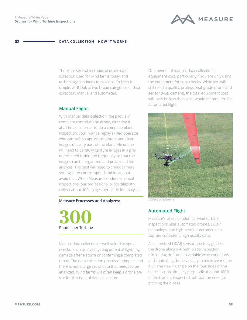
A customized LiDAR sensor precisely guides the drone along a 4-path blade inspection, eliminating drift due to variable wind conditions and controlling drone velocity to minimize motion blur. The viewing angle on the four sides of the blade is approximately perpendicular, and 100% of the blade is inspected, without the need for pitching the blades.
DATA COLLEC TION - HOW IT WOR K S02
LiDAR-guided drone

09MEASURE.COM
A Measure White Paper Drones for Wind Turbine Inspections
DATA COLLEC TION - HOW IT WOR K S02
A specialized flight plan is built based on a pre-developed pseudo 3D model of the wind turbine to be inspected. Once loaded with the 3D flight plan, the drone is ready to perform fully automated, and precisely repeatable, turbine blade inspections. The pilot only needs to setup the equipment, adjust the camera setting for the cloud-cover conditions, and start the inspection.
Inspection data can be captured with one of two different drone and payload options, providing varying levels of image resolution:
1. High resolution – a 20 mega pixel camera equipped on DJI M210 drone – This platform is typically used for routine O&M inspections.
2. Ultra-high resolution – a 47 mega pixel camera equipped on DJI M600 drone – This platform is typically used for warranty or insurance claim adjustment inspections.
Each inspection flight path has an area of interest -- leading edge, trailing edge or side (suction or pressure side). Images are always framed such that the area of interest is visible over the entire image height and as much of the blade is shown as possible, given the prescribed observation distance. Each path is composed of the same number of images and they are placed at the exact same altitude. This creates a virtual walk around the blade and enables cracks located near the trailing edge to be assessed from both sides of the blade.
Sample 3D model and flight path development
Sample high-resolution imagery

Data Analysis & DeliveryHow collected data is transformed into user-friendly inspection results.
010MEASURE.COM
A Measure White Paper Drones for Wind Turbine Inspections
DATA A N A LYSIS & DELI V ERY03

011MEASURE.COM
A Measure White Paper Drones for Wind Turbine Inspections
The analysis of turbine inspection data is typically outsourced to a data engineering expert, such as Measure. To make good use of your inspection data, you will need a well developed processing and analysis system, as well as a user-friendly platform for data delivery and storage.
Processing & Analysis
With each turbine inspection typically having about 300 images, and with wind farms typically having dozens, or even hundreds, of turbines, there are usually thousands of images that need to be processed and analyzed after each inspection.
Measure uses a four-step process to ensure that the large amount of raw imagery is translated into a quality inspection report:
1. Organizing and sorting data. This starts with capturing the data in a pre-determined, systematic way. Then, Measure applies a patent-pending method of automatically sorting and organizing large sets of turbine inspection images to make data processing more efficient.
2. Automated data processing. The organized data set is processed via advanced computing techniques using pattern recognition and artificial intelligence. Defects are automatically detected and categorized into pre-defined severity levels.
3. Data engineer review. An experienced data analyst will take a second pass through the data, looking for any false positives or false negatives and to conduct an overall quality check. Any errors will be fed back into the system to better train the automated processing model.
4. Blade expert review. As a final step, a blade expert reviews the damage classifications and adds well-informed commentary on the condition of defects and possible remedies.
Severity Description
1 None or minor cosmetic damage; no follow-up required
2 Moderate cosmetic damage or early wear; suggest re-inspection in 1 yr
3 Minor structural damage or advanced wear; suggest re-inspection in 6 months
4 Moderate structural damage; suggest repair at next maintenance cycle and re-inspection in 3 months
5 Major structural damage; recommend turbine stop and immediate repair
Classification system for defect severity level
Data Delivery
Data should be delivered through an easy-to-use report as well as an online portal that allows you to view, sort, track, and store your inspection results.
Your inspection deliverable should include:
• High-resolution imagery, located to each blade
• All defects classified by type and severity level
• User-friendly report of all defects
• Online portal to store and sort inspection data
When using a LiDAR system, you can also obtain spatial information about the blade. By merging the spatial meta data with the images, and adding automated blade edge detection and image brightness correction, it is possible to determine the position of a defect (within 10 cm) on the blade and its dimensions (within 5mm).
DATA A N A LYSIS & DELI V ERY03

012MEASURE.COM
A Measure White Paper Drones for Wind Turbine Inspections
Key defect measurements delivered when using a LiDAR system include:
• Distance from the root
• X-Y measurement of the defect
• Distance from the leading edge
Once the final data set is securely stored in an online web portal, it is easy for the asset manager to download customizable pdf or xls reports, as well as to look through the history of inspection results and perform portfolio analytics.
DATA A N A LYSIS & DELI V ERY03
Sample defect classification, type, and size delivered via online portal

013MEASURE.COM
A Measure White Paper Drones for Wind Turbine Inspections
DATA A N A LYSIS & DELI V ERY03
Because drones have proven themselves in the wind energy industry, they are being used more and more often, which means more and more data. Today, focus is on advancements in artificial intelligence (AI) and machine learning (ML) for data analysis. Measure’s data collection and analysis processes were developed with machine learning in mind, allowing us to build one of the largest turbine datasets available, with consistent labeling in a similar data type.
We were incredibly excited to work with AES, a Fortune 500 energy company, and Google to employ Google’s AutoML Vision technology to automatically identify defects and improve the speed of data analysis.
The ProcessMeasure provided raw data sets and annotated inspection imagery from hundreds of past AES turbine inspections, which were used to train Google’s Machine Learning/Computer Vision models. Measure’s expert data analysts worked with Google to validate and refine the model through each stage of development. Measure provides on-going expertise regarding turbine defect identification and classification to continuously advance the model’s results.
The BenefitsCombining Measure’s data set and wind turbine expertise with Google’s Auto ML has sped up the machine learning development process significantly. With machine learning, images with and without defects are identified, classified, and sorted automatically, vastly reducing the number of images requiring manual review and cutting the time between data collection and inspection
results delivery. As the ML algorithm becomes more and more refined, Measure’s experts will need to review fewer and fewer images, until we only need to examine a few images with specified defects in order to recommend the best course of action.
The ability to process and analyze data more quickly will both bring down costs and speed up data delivery time. AI enabled by machine learning is the key to getting timely inspection insights while reducing errors.
SIDEBAR: A Word About AI and Machine Learning

Drone Program BasicsWhat’s in an Enterprise Drone Program?
014MEASURE.COM
A Measure White Paper Drones for Wind Turbine Inspections
DRONE PROGR A M BA SICS04
015MEASURE.COM
A Measure White Paper Drones for Wind Turbine Inspections
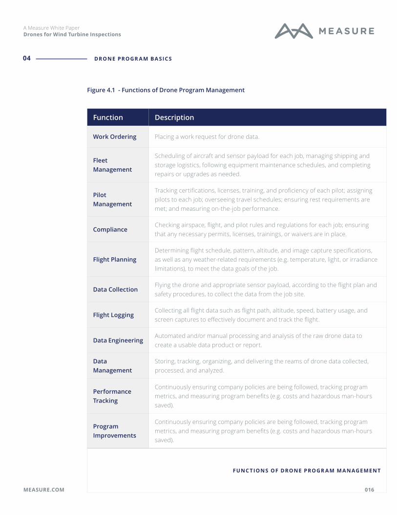
Once you’ve made the decision to add drones to your operations, it’s time to think practically about the setup and execution of your drone program. Managing a corporate drone program requires the coordination, oversight, and execution of a wide range of tasks and functions, as shown in Figure 4.1. How many of these functions your organization takes on will depend on the complexity of your operation and decisions regarding in-sourcing or out-sourcing. A helpful in-sourcing vs. out-sourcing decision guide is provided in Appendix A.
In Measure’s experience working in the wind industry, wind farm inspections are typically out-sourced to a third-party, while simple spot checks are conducted in-house by staff using basic drone equipment.
Inspections Spot checks
High equipment costs Low equipment costs
Infrequent (annual) More frequent
Planned in advance On demand
Complex data Basic data
Drone Program Manager
Most companies will begin by designating an internal manager to lead the program and oversee its many moving parts. Typically this would be one person from a central location - a Drone Program Manager. For particularly complex or global programs, companies might need several people to manage operations in their region or for a certain type of operation (e.g. disaster response). Regardless of how you are structured, you will need a Grand Central Station, of sorts, to manage your company’s drone operations.
The Drone Program Manager is responsible for ensuring all the functions of the program are running smoothly, whether accomplished in-house or contracted out. He or she will work with a team that might include in-house or contract pilots, trainers, drone engineers, and data analysts, among others. He or she may be ordering and/or tracking jobs; ensuring compliance with safety, regulatory, and company policies; managing equipment; and measuring program success. With so many people and functions to oversee, a program management software designed specifically for this purpose is crucial. Measure and Fortune 500 energy company, AES, use Measure Ground Control, a comprehensive software platform built based on real-world experience, to help run their complex drone programs.
Air Operations Manual
An Air Operations Manual is the foundational document of a professional drone program. It shapes the operational and safety culture of the organization. Each Air Operations Manual will be unique depending on the attributes of your organization, but should always address the following subjects (more details outlined inAppendix B).
• Authority & Control of Flights
• Regulatory Compliance Guidelines
• Training Standards
• Flight & Mission Planning Procedures
• Crew Resource Management
• Equipment Maintenance & Repair
• Mishap Reporting
DRONE PROGR A M BA SICS04
016MEASURE.COM
A Measure White Paper Drones for Wind Turbine Inspections
DRONE PROGR A M BA SICS04
Function Description
Work Ordering Placing a work request for drone data.
Fleet Management
Scheduling of aircraft and sensor payload for each job, managing shipping and storage logistics, following equipment maintenance schedules, and completing repairs or upgrades as needed.
Pilot Management
Tracking certifications, licenses, training, and proficiency of each pilot; assigning pilots to each job; overseeing travel schedules; ensuring rest requirements are met; and measuring on-the-job performance.
ComplianceChecking airspace, flight, and pilot rules and regulations for each job; ensuring that any necessary permits, licenses, trainings, or waivers are in place.
Flight PlanningDetermining flight schedule, pattern, altitude, and image capture specifications, as well as any weather-related requirements (e.g. temperature, light, or irradiance limitations), to meet the data goals of the job.
Data CollectionFlying the drone and appropriate sensor payload, according to the flight plan and safety procedures, to collect the data from the job site.
Flight LoggingCollecting all flight data such as flight path, altitude, speed, battery usage, and screen captures to effectively document and track the flight.
Data EngineeringAutomated and/or manual processing and analysis of the raw drone data to create a usable data product or report.
Data Management
Storing, tracking, organizing, and delivering the reams of drone data collected, processed, and analyzed.
Performance Tracking
Continuously ensuring company policies are being followed, tracking program metrics, and measuring program benefits (e.g. costs and hazardous man-hours saved).
Program Improvements
Continuously ensuring company policies are being followed, tracking program metrics, and measuring program benefits (e.g. costs and hazardous man-hours saved).
FUNC TIONS OF DRONE PROGR A M M A N AGEMENT
Figure 4.1 - Functions of Drone Program Management

017MEASURE.COM
A Measure White Paper Drones for Wind Turbine Inspections
Pilots & Pilot Training
An obvious part of any drone program is pilots. In-house pilots may be dedicated to the drone program, or they may combine drone operations with other job responsibilities. Often in the case of turbine asset management, select team members obtain their pilot license for regular spot checks, while third-party pilots are called in for larger inspections.
The FAA requires any sUAV operator to have a Part 107 certification before flying for any commercial purpose. However, that is only the first step. Measure recommends a training program that includes basic introductory training, along with training specific to the type of equipment the pilot will use and the application in which he will use it.
Introductory Training. Introductory training should cover the core principles of your organization’s program, such as maintenance guidelines, crew rest requirements, drug and alcohol policy, safety procedures, regulatory compliance, and more.
Drone-Specific Training. Drone pilots should receive hands-on training for the specific drone equipment they will be using, such as the DJI Inspire 2 or Phantom 4 Pro. This type of training sets a baseline for safe operation of aircraft and ensuring that pilots can adequately take manual control of the aircraft at any time to avoid hazardous situations.
Application-Specific Training. Pilots should be trained in the flight techniques specific to the industry application, such as standards and methods for flying on wind farms and capturing quality imagery of blade defects.
Drones and Sensors
The next obvious part of any drone program is, of course, the drones. When choosing the right equipment for a job, there are a number of factors to consider: type of operations, data requirements, security requirements, and cost. Common drone platforms are shown in Appendix C.
Drone aircraft come in two major physical configurations: multi-rotor and fixed-wing. Multi-rotor drones are well-suited to wind turbine inspections due to their maneuverability and ease of use, while fixed-wind drones are better suited to collect data over a broad area, such as for utility-scale solar inspections and in agriculture.
In the multi-rotor drone marketplace, DJI dominates with over 70% market share. DJI products offer quality and reliability at an
DRONE PROGR A M BA SICS04
Pilot training

018MEASURE.COM
A Measure White Paper Drones for Wind Turbine Inspections
affordable price, and they cover a wide range of applications and levels of sophistication.
For in-house drone programs, standardizing on one drone airframe will simplify aircraft maintenance and repair. DJI’s market dominance and expansive equipment selection makes it an attractive choice. DJI has come under a certain amount of scrutiny for data handling practices. These can be mitigated by using a feature called “Local Data Mode” available in select flight control applications, such as Measure Ground Control.
Just as important as the drone is the sensor payload. A high-resolution camera is key to capturing quality inspection images. As noted in a previous section, Measure offers two levels of resolution for wind inspections:
1. High resolution – a 20 mega pixel camera equipped on DJI M210 drone – This platform is typically used for routine O&M inspections.
2. Ultra-high resolution – a 47 mega pixel camera equipped on DJI M600 drone – This platform is typically used for warranty or insurance claim adjustment inspections.
The higher resolution, the higher the cost. When combining high resolution cameras with LiDAR equipment and a drone robust enough to carry the weight, the complete drone and payload package can exceed $50,000. Plus, you will need advanced knowledge to care for this type of equipment. This is one of the reasons why asset managers tend to outsource turbine inspections.
When conducting a simple spot check, a basic professional drone, such as the DJI Mavic Pro and RGB sensor (included) should suffice.
Program Management Software
As discussed previously, managing a drone program is a complex operation, covering many functions (see Fig 4.1). Looking across the drone software market, you will find a plethora of products targeted at one or a few of these functions. For example, there are popular software products focused only on flight logging or only on equipment management.
However, using a single software solution for as many functions as possible - work ordering, resource management, flight planning and tracking, data capture, program reporting, and compliance - will help you streamline your operations and manage your program more efficiently. You’ll also have the program oversight that most corporations need to ensure consistently safe and compliant execution of all aspects of their drone program.
Measure was searching for a comprehensive software platform to manage its own extensive drone operations. Unable to find a platform that met all of its needs, Measure built one, based on the experience of managing thousands of
DRONE PROGR A M BA SICS04
Pilots learning drone maintenance procedures

019MEASURE.COM
A Measure White Paper Drones for Wind Turbine Inspections
flights across myriad applications. That product is Measure Ground Control. A basic overview of Ground Control is provided in Appendix D.
Drone Data Software
Drone data is uploaded into various software platforms for processing, analysis, and visualization. Different software platforms are best suited for different types of applications and data needs. For example, the software used to process and analyze turbine inspection data will likely be different from what is used for inspections of electric lines and poles or for substations.
Since data processing and analysis of turbine inspections is typically out-sourced to a third party, you only need to worry about the usability of the final data product and how to best integrate the inspection results into your operations.
Always keep in mind who the stakeholders of your program are and who will need access to the data. Data that is difficult for asset managers or O&M teams to use is not likely to maximize your return on investment. Make sure that the processing and analysis of your drone data results in a data deliverable that can drive better decisions for your business operations.
DRONE PROGR A M BA SICS04
Measure Ground Control Flight Application: LAANC airspace authorization

020MEASURE.COM
A Measure White Paper Drones for Wind Turbine Inspections
In this paper, we have reviewed the benefits of drones for wind farm inspections. We have covered the processes involved with data collection, analysis, and delivery; and we have introduced the components of a drone program. Drones can make a significant improvement in your wind farm operations, and we hope that you will take advantage of this new technology today.
If you are looking to add drones to your wind farm operations, Measure can help. Measure offers a range of products and services, from complete inspection services to pilot training and a la carte data analysis. Contact us for more information on:
• Turnkey Drone Operations
• Drone Program Software
• Drone Data Analysis
• Hands-on Pilot Training
• Advisory Services
When you’re ready to get started or want to take your existing program to the next level, drop us a line at https://www.measure.com/contact.
Conclusion

021MEASURE.COM
A Measure White Paper Drones for Wind Turbine Inspections
A PPENDI X A : INSOURCE VS . OUT SOURCE DECISION GUIDEA
Insource vs. Outsource Decision Guide
Insource Outsource
Pilot skills required Low . . . . . . . . . . . . . . . High
In-house data engineering skills & software
Available . . . . . . . . . . . . . . . Not Available
Hardware costs Low . . . . . . . . . . . . . . . High
Program execution costs (software, insurance, management)
Low . . . . . . . . . . . . . . . High
Risk tolerance High . . . . . . . . . . . . . . . Low
Data complexityLow (e.g. visual pictures only)
. . . . . . . . . . . . . . .High (hundreds of
images, thermal analysis, etc)
Inspected asset valueLow (e.g. bare earth)
. . . . . . . . . . . . . . .High (e.g. wind
turbines, cell towers)
Mission risk conditionsLow (e.g. empty site)
. . . . . . . . . . . . . . .High (hazardous
environment)
Flight locationsSpecific sites with on-site staff
. . . . . . . . . . . . . . .Disperse, unknown,
or unstaffed locations
Flight frequency High (daily, weekly) . . . . . . . . . . . . . . .Low (monthly,
annually)
Flight predictabilityLow (on-demand, reactive)
. . . . . . . . . . . . . . .High (planned in
advance)
INSOURCE VS . OUT SOURCE DECISION GUIDE

022MEASURE.COM
A Measure White Paper Drones for Wind Turbine Inspections
A PPENDI X B: COMPONENT S OF A N A IR OPER ATIONS M A NUA LB
Subject Purpose Considerations
Authority & Control of Flights
Establish who has authority to approve flight operations under what circumstances
Who can put in a request for drone operations?
How are operations reviewed and approved?
What authorities do the approver and the pilot-in-command have?
Regulatory Compliance Guidelines
Unequivocally state that all applicable rules and regulations must be followed
What federal, state, and local regulations affect your operations?
What is the process for requesting regulatory waivers?
What other regulatory guidelines (e.g. FCC) may apply?
Training Standards
Stipulate pilot training requirements by mission type and ensure only qualified pilots are flying
What training is required for each of your mission types?
How often must training be renewed?
Do training requirements differ between employee and contract pilots?
Flight & Mission Planning Procedures
Ensure consistently successful aerial data collection and safe flight outcomes
What are your data collection requirements?
What is the type, location, and timing of the mission?
How are you managing your equipment and pilots?
A IR OPER ATIONS M A NUA L
Components of an Air Operations Manual

023MEASURE.COM
A Measure White Paper Drones for Wind Turbine Inspections
A PPENDI X B CONT ’ D: COMPONENT S OF A N A IR OPER ATIONS M A NUA LB
Continued:Components of an Air Operations Manual
Subject Purpose Considerations
Crew Resource Management
Reduce and mitigate errors related to human factors in in-field flight operations
What are your crew rest requirements?
How do factors like weather or stress impact pilot scheduling?
How are crew errors or infractions addressed?
Equipment Maintenance and Repair
Reduce safety hazards, downtime, and data quality issues due to malfunctioning equipment
Who will be responsible for drone maintenance and repair?
What are your pre-and post- flight maintenance procedures?
How will you track equipment usage over time?
Mishap Reporting
Determine policies and procedures for when accidents happen
What severity of accident warrants a report?
Who needs to be informed when an accident happens?
What information needs to be collected at the scene and by whom?
Who will be responsible for filing a mishap report?
A IR OPER ATIONS M A NUA L

024MEASURE.COM
A Measure White Paper Drones for Wind Turbine Inspections
Drone Make & Model
Style Specs Best For Notes
DJI Mavic Pro Multirotor
Max Flight Time: 27 min
Wind Resistance: 10 m/s
Basic operations
Good for tactical situational awareness for emergency response, small-scale mapping, and basic image capture. Excellent portability, low price point, and ease of use.
DJI Inspire 2 Multirotor
Max Flight Time: 27 min
Wind Resistance: 10 m/s
All purpose
The workhorse in the industry; rugged and field-tested. Excellent all-purpose drone.
DJI M210 Multirotor
Max Flight Time: 38 min
Wind Resistance: 12 m/s
All purposeDual gimbal payload allows for simultaneous thermal and RGB data collection.
DJI M600 Multirotor
Max Flight Time: 40 min
Wind Resistance: 8 m/s
Heavier payloads
This larger airframe accepts more advanced camera equipment, such as used in cinematography
senseFly eBee
Fixed-wing
Max Flight Time: 50 min
Wind Resistance: 12 m/s
Flights over large areas
Lacks maneuverability of multirotors, but has superior endurance. Best choice for large-scale mapping missions in mining, solar, agriculture, and large construction sites.
DRONE EQUIPMENT 2 019
A PPENDI X C: COMMON COMMERCI A L DRONE H A R DWA R EC

025MEASURE.COM
A Measure White Paper Drones for Wind Turbine Inspections
A PPENDI X D: ME A SUR E GROUND CONTROL FE ATUR ESD
M A N AGE PEOPLE & EQUIPMENT
• Keep tabs on the activities, certifications, and training of your team
• Setup user profiles with location, credentials, experience, and status
• Control user permission with pre-defined roles
• Manage all equipment with automatic usage tracking and maintenance recommendations
• Store equipment details, create kits, and disable or quarantine equipment as needed
• Get reports of pilot and equipment activity
SCHEDULE & PL A N FLIGHT S
• Create and schedule missions, and manage the program calendar
• Assign pilots, equipment, and other resources to missions
• Automate task assignments
• Check airspace
• Design and upload flight plans
• Set company-wide flight parameters
FLY & COLLEC T DATA
• Check weather and airspace conditions
• Request LAANC authorization
• Retrieve and apply DJI Geo Unlock
• Fly with GPS-aided manual control or automated grid and waypoint patterns
• Use active track modes spotlight, POI, trace, orbit, and profile
• Automatically upload flight logs, screen captures, and completed checklists
• Block DJI data sharing with local data mode
TR ACK & REPORT AC TI V IT Y
• Access automatically uploaded flight logs, including flight playback and screen captures
• Review pre- and post- flight checklists
• Create and export reports and flight data
• View dashboards of program metrics
A N A LY ZE & S TORE DATA
• Store unlimited flight logs, imagery, video, and upladed files
• Add inspection results and review mission and portfolio-level summaries
• Upload completed data products to missions
• Access integrated visualization tools to view inspection data

Thank You