introduction of sentinel asia - a web-gis platform for ... · 1 kenpei kojika ([email protected])....
TRANSCRIPT

1
Kenpei Kojika ([email protected])Asian Disaster Reduction Center (ADRC)
ITU/ESCAP Disaster Communications Workshop, 12–15 December 2006, Bangkok, Thailand
Introduction of Sentinel Asia - a Web-GIS Platform for Disaster Management -

22
Background• APRSAF-11, Nov 2004, Australia, agreed that a
coordinated rapid-response pilot project should be developed for effective disaster reduction in Asia-Pacific region
• APRSAF technical WS: “Disaster Reduction through Effective Space Technology Utilization in the Asia Pacific Region”, held in May 2005, Malaysia, discussed the pilot project plan
• APRSAF-12, Oct 2005, Japan, approved the plan and initiated the pilot project
• The 1st Joint Project Team Meeting, Feb 2006, Vietnam, discussed the project implementation plan and JPT membership.
(APRSAF: Asia-Pacific Regional Space Agency Forum)

33
Sentinel AsiaSentinel Asia
APRSAF*Space Community
Satellite ImageContent
Promotion of Utilization
Capacity Building
Web-GISData / Meta Data Management
Information Sharing Platform
Content
Digital Asia
Digital Earth / Web-GISCommunity
Digital MapSocial / Economic DataSatellite Image
Disaster Reduction Community
Disaster Information
Content
Utilization (User)
ADRC**Member Countries
Framework
UN / ESCAP UN / OOSAASEAN AIT etc.
International Community
International Cooperation
** Asian Disaster Reduction Center
Joint Project Team (JPT)Join Project Team consists of total 51
organizations including 44
agencies from 18
countries and 7
international organizations as of July 2006.
Voluntary and best-efforts-basis initiative by participating organizations and cooperation among APRSAF, ADRC, Digital Asia and international organizations
* Asian Disaster Reduction Center
* Asian-Pacific RegionalSpace Agency Forum

44
Main Activities- Emergency observation in case of major
disasters by ALOS and other available resources for ADRC members and JPT space agencies
- Wildfire monitoring by MODIS
- Flood monitoring by TRMM and AMSER-E
- Capacity-building for utilization of satellite images for disaster management
Accept emergency observation from October 24, 2006

55
Overall Flow

66
Users of Sentinel Asia
ADRC• Disaster Information
Keio Univ. (Digital Earth Server)
• A Millionth Digital Map covering Entire Asia
• LANDSAT Images covering Entire Asia• Social・Economic Data ( eg. Population Distribution Map)
Space AgencyResearch and Trainig Nodes
• Satellite Images before and after Disaster
• Satellite Images for GIS and FTP• Analized Images with Value-added
On-site Disaster OrganizationInvestigating Delegation
• On-the-spot Digital Camera Images• Ground Truth Data• Fine Regional Digital Maps
・Disasters in the Asia-Pacific region and so on
List of Disasters
・Satellite Image is overlaid on Map by Web-GIS
Overlaid Images
• Images of Stricken Area• Ground Truth Data
Digital Camera Images
・Original Satellite Images for FTP
FTP Images
The Public
• To Grasp a State of Disasters
Disaster OrganizationsADRC Member
• Policy and Decision Making
User Nodes Research/Training Nodes
Space Agency
• Analysis• Prosessing by own GIS
Data ProviderDisaster-related Informationprovided by Sentinel Asia User
Data Interface
77
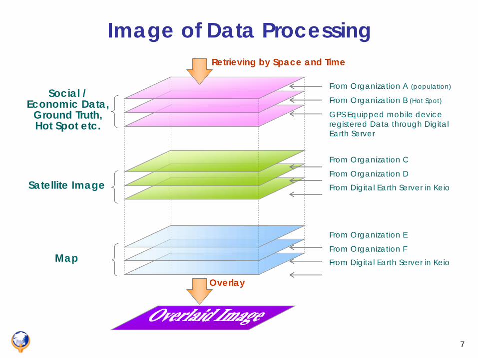
Overlay
From Organization E
From Organization F
From Organization C
From Organization D
From Digital Earth Server in Keio
From Organization A (population)
GPS Equipped mobile device registered Data through Digital Earth Server
From Organization B (Hot Spot)Social /
Economic Data, Ground Truth, Hot Spot etc.
Satellite Image
Map From Digital Earth Server in Keio
Retrieving by Space and Time
Image of Data Processing

88
ADRC(Asian Disaster Reduction Center)
Asia Disaster Management Agencies(ADRC member countries and JPT space agencies)
JAXA
Request
Information Desk
Satellite observation planning DisasterDisaster!!
Disaster Observation by ALOS
GIS service with Satellite Image(for Public)
InternetAccess
ADRC’s Disaster Information
Remote-Sensing by JAXA
Making use of a Web-GIS platform developed by “Digital Asia” project(lead by Keio Univ.)
Integrated Disaster Information
Satellite Raw Data and Images(for registered users)
Operation Flow of ALOS Observation

99
http://dmss.tksc.jaxa.jp/sentinel/index.php
1010
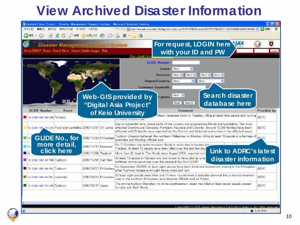
View Archived Disaster Information
For request, LOGIN here with your ID and PW
GLIDE No., for more detail, click here
Web-GIS provided by “Digital Asia Project”
of Keio University
Link to ADRC’s latest disaster information
Search disaster database here

1111
Detail Information of a Disaster
Satellite images
Locations of satellite images and site photos
Site photos

1212
Satellite Disaster Image
1313
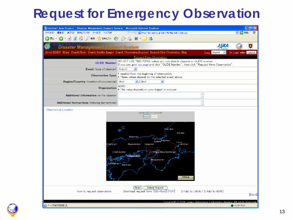
Request for Emergency Observation

1414
Provisions for Emergency ObservationADRC counterpart organizations and space agencies of JPT are eligible to request for the emergency observation by ALOS (ID and PW required)
Apply to any kind of large-scale natural disasters
The result is provided free-of-charge and no commercial use is allowed for provided observation data and images

1515
Limitations of Sentinel AsiaBest-effort based system: request may not be accepted and the quality of the result is not guaranteed
It may take time from request to data dissemination due to the position of the satellite and weather condition
Remote sensing technology may be necessary for accurate damage estimation
Archived data are not always available when the damage estimation requires
1616
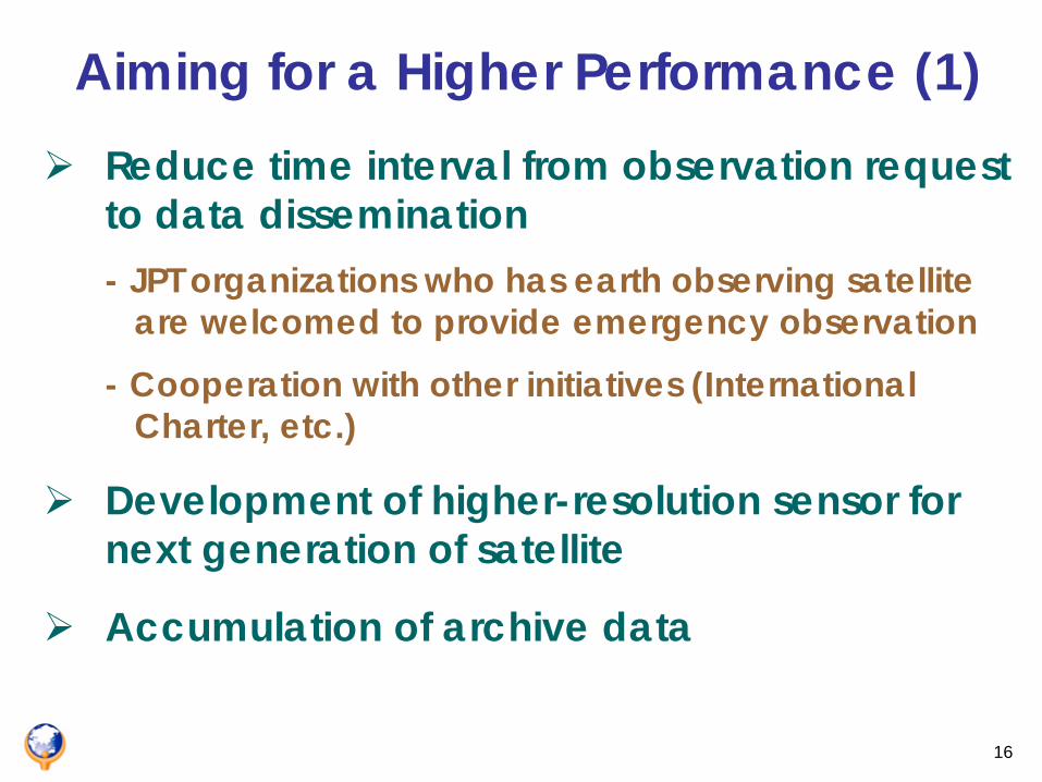
Aiming for a Higher Performance (1)Reduce time interval from observation request to data dissemination- JPT organizations who has earth observing satellite
are welcomed to provide emergency observation
- Cooperation with other initiatives (International Charter, etc.)
Development of higher-resolution sensor for next generation of satellite
Accumulation of archive data

1717
Aiming for a Higher Performance (2)Development of remote sensing technology and damage estimation algorism- To provide different kinds of information to satisfy
various requirement of disaster management
Combination with information communication technology to improve Internet environment- To utilize WINDS (Wideband Internetworking Engineering
Test and Demonstration Satellite) from 2008

1818
Joining International Charter
ADRC
1919
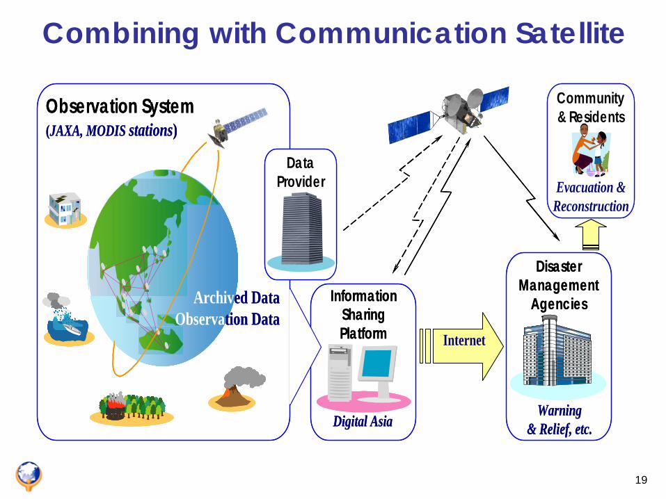
Combining with Communication Satellite
Observation System
Digital Asia
InformationSharingPlatform Internet
DataProvider
DisasterManagement
Agencies
Warning& Relief, etc.
(JAXA, MODIS stations)
Community& Residents
Evacuation &Reconstruction
Archived DataObservation Data
Observation System
Digital Asia
InformationSharingPlatform Internet
DataProvider
DataProvider
DisasterManagement
Agencies
Warning& Relief, etc.
(JAXA, MODIS stations)
Community& Residents
Evacuation &Reconstruction
Community& Residents
Evacuation &Reconstruction
Archived DataObservation Data

2020
SUMMARYSentinel-Asia was a internet-based Web-GIS platform providing disaster information in the Asia-Pacific region under cooperation among APRSAF, ADRC, Digital Asia and international organizations based on best-efforts and voluntary initiatives
Accepts emergency disaster observation by ALOS at present after a large-scale disaster and the wildfire and flood monitoring will function soon
It could be a useful tool for disaster management especially when it is combined with local GIS, social and economic information
Utilization of communication satellite is expect to speed or enable real time disaster information exchange between the data providers and the end users

2121
Thank you for your attention