introductions to heritage assets - oppida · 2012-05-03 · historic places helping people to...
TRANSCRIPT

Oppida
On 1st April 2015 the Historic Buildings and Monuments Commission for England changed its common name from English Heritage to Historic England. We are now re-branding all our documents. Although this document refers to English Heritage, it is still the Commission's current advice and guidance and will in due course be re-branded as Historic England.
Please see our website for up to date contact information, and further
advice.
We welcome feedback to help improve this document, which will be periodically revised. Please email comments to [email protected]
We are the government's expert advisory service for England's historic environment. We give constructive advice to local authorities, owners and the public. We champion historic places helping people to understand, value and care for them, now and for the future.
HistoricEngland.org.uk/advice

Introductions to Heritage Assets
Oppida
May 2011
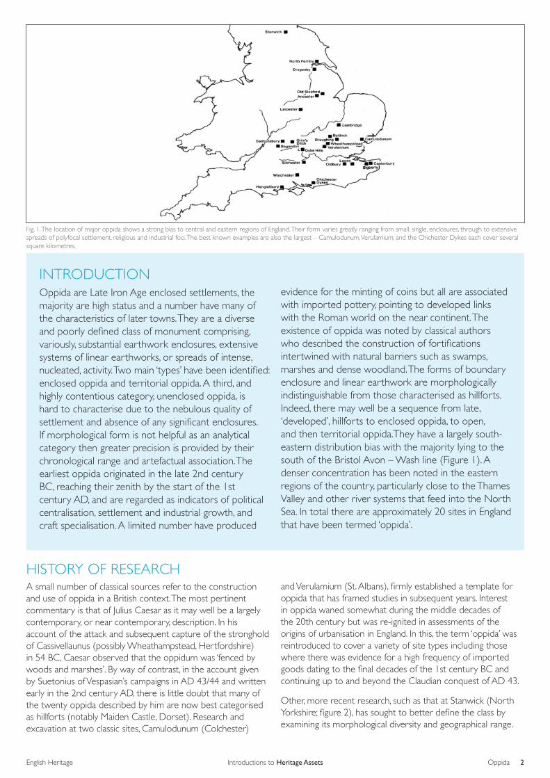
Fig. 1. The location of major oppida shows a strong bias to central and eastern regions of England. Their form varies greatly ranging from small, single, enclosures, through to extensive spreads of polyfocal settlement, religious and industrial foci. The best known examples are also the largest – Camulodunum, Verulamium, and the Chichester Dykes each cover several square kilometres.
2Introductions to Heritage AssetsEnglish Heritage Oppida
INTRODUCTIONOppida are Late Iron Age enclosed settlements, the majority are high status and a number have many of the characteristics of later towns. They are a diverse and poorly defined class of monument comprising, variously, substantial earthwork enclosures, extensive systems of linear earthworks, or spreads of intense, nucleated, activity. Two main ‘types’ have been identified: enclosed oppida and territorial oppida. A third, and highly contentious category, unenclosed oppida, is hard to characterise due to the nebulous quality of settlement and absence of any significant enclosures. If morphological form is not helpful as an analytical category then greater precision is provided by their chronological range and artefactual association. The earliest oppida originated in the late 2nd century BC, reaching their zenith by the start of the 1st century AD, and are regarded as indicators of political centralisation, settlement and industrial growth, and craft specialisation. A limited number have produced
evidence for the minting of coins but all are associated with imported pottery, pointing to developed links with the Roman world on the near continent. The existence of oppida was noted by classical authors who described the construction of fortifications intertwined with natural barriers such as swamps, marshes and dense woodland. The forms of boundary enclosure and linear earthwork are morphologically indistinguishable from those characterised as hillforts. Indeed, there may well be a sequence from late, ‘developed’, hillforts to enclosed oppida, to open, and then territorial oppida.They have a largely south-eastern distribution bias with the majority lying to the south of the Bristol Avon – Wash line (Figure 1). A denser concentration has been noted in the eastern regions of the country, particularly close to the Thames Valley and other river systems that feed into the North Sea. In total there are approximately 20 sites in England that have been termed ‘oppida’.
HISTORY OF RESEARCH A small number of classical sources refer to the construction and use of oppida in a British context. The most pertinent commentary is that of Julius Caesar as it may well be a largely contemporary, or near contemporary, description. In his account of the attack and subsequent capture of the stronghold of Cassivellaunus (possibly Wheathampstead, Hertfordshire) in 54 BC, Caesar observed that the oppidum was ‘fenced by woods and marshes’. By way of contrast, in the account given by Suetonius of Vespasian’s campaigns in AD 43/44 and written early in the 2nd century AD, there is little doubt that many of the twenty oppida described by him are now best categorised as hillforts (notably Maiden Castle, Dorset). Research and excavation at two classic sites, Camulodunum (Colchester)
and Verulamium (St. Albans), firmly established a template for oppida that has framed studies in subsequent years. Interest in oppida waned somewhat during the middle decades of the 20th century but was re-ignited in assessments of the origins of urbanisation in England. In this, the term ‘oppida’ was reintroduced to cover a variety of site types including those where there was evidence for a high frequency of imported goods dating to the final decades of the 1st century BC and continuing up to and beyond the Claudian conquest of AD 43.
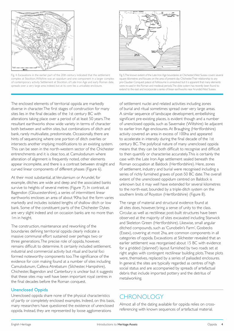
Other, more recent research, such as that at Stanwick (North Yorkshire; figure 2), has sought to better define the class by examining its morphological diversity and geographical range.

3OppidaIntroductions to Heritage AssetsEnglish Heritage
Fig. 2. The northernmost properly attested oppida in England is found at Stanwick, North Yorkshire. The site is much more compact in layout than some of the larger examples but it is, nonetheless, an impressive site defined by extensive and well-defined earthwork boundaries.
Fig. 3. The enclosed oppidum at Dyke Hills, Oxfordshire, stands in marked contrast to the larger, polyfocal, examples found in the eastern counties of England. It covers an area of about 45 hectares and occupies an important landscape setting, at the confluence of two major river networks, the Thames and the Thame.
DESCRIPTIONThe term ‘Oppida’ has been used to describe so many obviously different types of site that a number of authors have cast doubt upon its utility. Nonetheless, it is apparent that a majority of those called ‘oppida’ often comprise a set of morphological, artefactual and chronological characteristics that are combined in varying degrees of completeness.
Enclosed OppidaThe primary components, especially noted in earlier enclosed oppida as well as larger and later, territorial oppida, are extensive systems of linear ditch. In the former, these are defined by relatively discrete but extensive enclosures such as that at Wheathampstead, on the River Lea (Hertfordshire). This enclosure lies in a low, riverside, location and enclosed an area of close on to 40ha, thus much larger than the vast majority of earlier developed hillforts. Indeed, all enclosed oppida cover areas in excess of 10ha, but there is considerable variety: Dyke Hills (Oxfordshire) is 46ha in area (Figure 3), whilst Loose (Kent) encloses approximately 12 ha. The enclosure boundaries mimic those of hillforts but often on a much larger scale with strong, deeply incised, V-shaped ditches. They can be found in all topographical locations, hilltops, valley sides, with river valleys being preferred locations. It is noticeable, however, that these enclosures are often incomplete, and utilised marked natural barriers such as rivers, streams or prominent topographical boundaries; a very small number indeed, such as Salmonsbury (Gloucestershire), re-use the sites of earlier hillforts.
Many of the enclosed oppida are located in areas that are well suited to exploit links in local and extra-regional communications and trade networks. The Late Iron Age entrepôt at Hengistbury Head (Dorset) is bounded by a massive double bank and ditch that isolates a very prominent headland at the mouth of the River Avon as it flows into the English Channel. This headland is a highly visible landmark and the range of material found here, including a substantial number and wide variety of imported goods, underscored its role as an important trade and proto-urban centre at the end of the Iron Age.
Territorial OppidaThe scale of enclosed oppida is dwarfed by that apparent in those referred to as ‘territorial’. On occasion, though, the two are found in close association: Bigbury enclosure and Canterbury in Kent; and Wheathampstead and Verulamium; while at least two earlier enclosures underlie the Late Iron Age levels at Stockton (Wiltshire), part of the Nadder-Wylye Ridge oppidum (Figure 4). It is probable that the smaller, enclosed elements pre-dated the creation of the larger ‘territorial’ units. The principal defining characteristic of these is the widespread system of related linear earthworks, many of which extend for considerable distances. The Nadder-Wylye Ridge territorial oppidum occupies a prominent ridge-top location above the valley of the river Wylye. Here, four major foci covering an area of at least 90ha are enclosed within a linear ditch that extends for 16km. Often, though, these sites are found in low-lying positions and many enclose substantial tracts of river valley systems, indeed, all territorial oppida are intimately associated with riverine networks. Perhaps the best known and most heavily investigated example is Camulodunum (Essex). Here, the dyke system encloses a massive area of land between the Roman River and the Colne but there are additional stretches of boundary that extend for several kilometres to the north. At least 31 sq km is enclosed and although fieldwork has revealed the complexity of layout, the sequence of enclosure is not at all clear. The dykes at Chichester encompass at least 150 sq km at their fullest but may well have extended further to the east, bounded by the River Arun and thus incorporated much of the coastal plain of West Sussex with a suspected focus on Selsey Bill (Figure 5).
The evidence from territorial oppida suggests that these were significant places before they were embellished by the ditch systems. Camulodunum exemplifies this and was the setting for an earlier, widely dispersed, complex that included open and enclosed and possibly ‘high status’ settlement, as well as industrial, burial and ritual foci. The extent of pre-oppida activity at Verulamium is not well known but it certainly included smaller enclosed and open elements, such as Prae Wood, which were subsumed within a much greater entity.
Introductions to Heritage AssetsEnglish Heritage 4Oppida
Fig. 4. Excavations in the earlier part of the 20th century indicated that the settlement complex at Stockton, Wiltshire was an oppidum and one component in a larger complex of contemporary activity. Settlement at Stockton, of Late Iron Age and early Roman date, spreads over a very large area indeed, but at its core lies a univallate enclosure.
Fig. 5. The known extent of the Late Iron Age boundaries at Chichester, West Sussex covers several square kilometres and focuses on the area of present-day Chichester. Their relationship to any pre-Claudian Conquest palace at Fishbourne is unresolved but it is apparent that many elements were re-used in the Roman and medieval periods. The dyke system has recently been found to extend to the east and incorporate a series of linear earthworks near Arundel, West Sussex.
The enclosed elements of territorial oppida are markedly diverse in character. The first stages of construction for many sites lies in the final decades of the 1st century BC with alterations taking place over a period of at least 50 years. The resultant earthworks show wide variety in terms of character both between and within sites, but combinations of ditch and bank, rarely multivallate, predominate. Occasionally, there are hints of sequencing where one portion of ditch overlies or intersects another implying modifications to an existing system. This can be seen in the north-western sector of the Chichester entrenchments and it is clear, too, at Camulodunum where alteration of alignment is frequently noted, other elements appear incomplete, and there is a contrast between straight and curved linear components of different phases (Figure 6).
At their most substantial, at Verulamium or Arundel, for example, ditches are wide and deep and the associated banks survive to heights of several metres (Figure 7). In contrast, at Bagendon (Gloucestershire), a series of intermittent linear earthworks encloses an area of about 90ha but the form varies markedly and includes isolated lengths of shallow ditch or low bank. Some of the constituent parts of the Chichester Dykes are very slight indeed and on occasion banks are no more than 1m in height.
The construction, maintenance and reworking of the boundaries defining territorial oppida clearly indicate a massive communal effort sustained over perhaps two or three generations. The precise role of oppida, however, remains difficult to determine. It certainly included settlement, industrial and commercial activity but ritual and burial foci formed noteworthy components too. The significance of the evidence for coin making found at a number of sites including Camulodunum, Calleva Atrebatum (Silchester, Hampshire), Chichester, Bagendon and Canterbury is unclear but it suggests that these sites may well have been important royal centres in the final decades before the Roman conquest.
Unenclosed OppidaUnenclosed oppida share none of the physical characteristics of partly or completely enclosed examples. Indeed, on this basis, many researchers have questioned the existence of unenclosed oppida. Instead, they are represented by loose agglomerations
of settlement nuclei and related activities including zones of burial and ritual sometimes spread over very large areas. A similar sequence of landscape development, embellishing significant pre-existing places, is evident though and a number of unenclosed oppida, such as Savernake (Wiltshire) lie adjacent to earlier Iron Age enclosures. At Braughing (Hertfordshire) activity covered an area in excess of 100ha and appeared to accelerate in intensity during the final decade of the 1st century BC. The polyfocal nature of many unenclosed oppida means that they can be both difficult to recognise and difficult to then quantify or characterise accurately. This is certainly the case with the Late Iron Age settlement sealed beneath the Roman occupation at Baldock (Hertfordshire). Here, zones of settlement, industry and burial were recognised including a series of richly furnished graves of post-50 BC date. The overall extent of the unenclosed oppidum centred on Baldock is unknown but it may well have extended for several kilometres to the north-east, bounded by a triple-ditch system on the southern limits of Royston (Hertfordshire) (Figure 8).
The range of material and structural evidence found at all sites does, however, bring a sense of unity to the class. Circular, as well as rectilinear, post-built structures have been observed at the majority of sites excavated including Stanwick and Skeleton Green (Hertfordshire). Likewise, small angular ditched compounds, such as ‘Cunobelin’s Farm’, Gosbecks (Essex), covering at most 2ha, are common components in all categories of oppida. Excavations at Silchester revealed that an earlier settlement was reorganised about 15 BC with evidence for a gridded (‘planned’) layout furnished by two roads set at right angles with contingent rectilinear building plots. These plots were, themselves, replaced by a series of palisaded enclosures. In general, the sites are typically regarded as centres of high social status and are accompanied by spreads of artefactual debris that include imported pottery and the detritus of metalworking.
CHRONOLOGY Almost all of the dating available for oppida relies on cross-referencing with known sequences of artefactual material.

Introductions to Heritage AssetsEnglish Heritage 5Oppida
Fig. 6. Camulodunum, Colchester, Essex is, perhaps, the best-known of the large territorial oppida – it is certainly the most extensively investigated and is routinely referred to as ‘the oldest town in England’. The earliest major boundaries were probably constructed here in the final quarter of the 1st century BC and the complex included settlement, industrial, as well as ritual and burial foci.
Fig. 7. The War Ditches, Arundel, West Sussex were long thought to be of medieval date but recent work indicates that they are of Late Iron Age date and enclose close on to 23 square kms. Within the enclosed area there are a number of enclosed settlements shown by excavation to have been established in the decades between the Caesarean campaigns and those of Claudius (mid 1st century BC to mid 1st century AD).
In particular, the pottery found in a variety of contexts, on all sites, is demonstrative of contact with Roman markets on mainland Europe and is dominated by imported Gallo-Belgic wares and Arretine vessels which can be closely dated on typological grounds. Further chronological information is provided by stratigraphic relationships. In a number of cases, for example, at Winchester and Colchester, sites are succeeded by early Roman towns.
On the basis of present evidence, it appears that a number of sites, including Braughing, Silchester and Gussage (Dorset), emerged during the late 2nd/early 1st century BC and many continued in use through to the end of the 1st century AD. This apparent continuity undoubtedly masks important changes in the physical character of the sites and shifts in the spatial setting of activities within them. This is evident at Wheathampstead enclosed oppidum, where significant decline, apparent by about 10 BC, was complemented by the development of Verulamium territorial oppidum 8km to the south-west. Further changes of emphasis which are perhaps more subtle in character can be detected at Winchester. Here, intensive occupation dating from the late 2nd century BC to the 1st century AD appeared to be continuous, but it would seem that the nucleus of the settlement shifted towards the river Itchen sometime during the first half of the 1st century AD.
ASSOCIATIONS There are frequent stratigraphical and spatial associations between oppida and a wide range of pre-existing and later structures. Perhaps the most commonly observed association is between oppida and earlier, later prehistoric enclosures. The unenclosed oppidum at Braughing is contiguous with Gatesbury
Camp hillfort and at least two small hillfort enclosures were subsumed within Stockton complex, part of the Nadder-Wylye Ridge territorial oppidum. At Hamshill Ditches, part of the same oppidum, two well preserved banjo enclosures have been incorporated within the earthworks. Here, too, earlier coaxial fields could be traced but this is a very rare observation.
Earlier settlement, dating to about 25 BC was uncovered at Silchester and in other places, such as Dyke Hills (Oxfordshire) aerial photographs reveal traces of underlying, and more widespread, open settlement. A small number of oppida make use of refurbished hillfort boundaries such as Salmonsbury Camp (Gloucestershire), Bigbury Camp (Kent) and, possibly, Wallbury Camp (Essex).
Both Verulamium and Camulodunum were immediately superseded by the establishment of early Roman towns and a similar relationship is evident at Baldock too. Roman period activity is present at Stanwick, and it may well be that it remained a place of authority until a church was founded there sometime in the 8th century AD.
FURTHER READING Undoubtedly the best introduction to oppida and the general contextual background can be found in Barry Cunliffe Iron Age Communities in Britain (4th edition, 2005). A number of other recent publications similarly provide detail and background information on oppida, including John Creighton, Coins and Power in Late Iron Age Britain (2000). More detailed, and often site specific, information is available in a number specialist publications but none of these is recent in date. Two publications stand out though. Firstly, Barry Cunliffe and Trevor Rowley, Oppida in Barbarian Europe (1976) in which the first full inventory of oppida in Britain was presented and, secondly, John Collis, Oppida, Earliest Towns North of the Alps (1984) setting British sites in their wider European context.

Introductions to Heritage AssetsEnglish Heritage 6Oppida
Fig. 8. The triple linear ditch system at Therfield Heath, Hertfordshire, can be seen as three, narrow, parallel lines running from top to bottom to right of centre. These are likely to be the north-eastern boundary of a large unenclosed oppidum centred on Baldock several kilometres to the south-west.
CREDITSAuthor: Dave McOmish
Cover: The War Ditches, Arundel, West Sussex (as Figure 7).
Figures 1-2, 6: © Martin Millett Figure 3: © Barry Cunliffe Figure 4: © RCHME Figure 5: © Owen Bedwin Figure 7: © English Heritage Figure 8: © Google Earth
If you would like this document in a different format, please contact our Customer Services department:
Telephone: 0870 333 1181
Fax: 01793 414926
Textphone: 01793 414878
E-mail: [email protected]