inuenza a h5n1 and h7n9 in china: a spatial risk analysis...zoonotic avian influenza virus (aiv) of...
TRANSCRIPT

2/12/2019 Influenza A H5N1 and H7N9 in China: A spatial risk analysis
https://journals.plos.org/plosone/article?id=10.1371/journal.pone.0174980 1/19
bstractackground
oonotic avian influenza poses a major risk to China, and other parts of the world. H5N1 has remained endemic in China andlobally for nearly two decades, and in 2013, a novel zoonotic influenza A subtype H7N9 emerged in China. This study aimed to
improve upon our current understanding of the spreading mechanisms of H7N9 and H5N1 by generating spatial risk profiles forach of the two virus subtypes across mainland China.
ethods and findings
In this study, we (i) developed a refined data set of H5N1 and H7N9 locations with consideration of animal/animal environment caseata, as well as spatial accuracy and precision; (ii) used this data set along with environmental variables to build speciesistribution models (SDMs) for each virus subtype in high resolution spatial units of 1km cells using Maxent; (iii) developed a riskodelling framework which integrated the results from the SDMs with human and chicken population variables, which was done touantify the risk of zoonotic transmission; and (iv) identified areas at high risk of H5N1 and H7N9 transmission. We produced higherforming SDMs (6 of 8 models with AUC > 0.9) for both H5N1 and H7N9. In all our SDMs, H7N9 consistently showed higher AUCesults compared to H5N1, suggesting H7N9 suitability could be better explained by environmental variables. For both subtypes,igh risk areas were primarily located in south-eastern China, with H5N1 distributions found to be more diffuse and extending more
inland compared to H7N9.
onclusions
e provide projections of our risk models to public health policy makers so that specific high risk areas can be targeted for controleasures. We recommend comparing H5N1 and H7N9 prevalence rates and survivability in the natural environment to betternderstand the role of animal and environmental transmission in human infections.
Citation: Bui CM, Gardner L, MacIntyre R, Sarkar S (2017) Influenza A H5N1 and H7N9 in China: A spatial risk analysis.PLoS ONE 12(4): e0174980. https://doi.org/10.1371/journal.pone.0174980
Editor: Gui-Quan Sun, Shanxi University, CHINA
Received: December 19, 2016; Accepted: March 19, 2017; Published: April 4, 2017
Copyright: © 2017 Bui et al. This is an open access article distributed under the terms of the Creative Commons AttributionLicense, which permits unrestricted use, distribution, and reproduction in any medium, provided the original author andsource are credited.
Data Availability: All relevant data are within the paper and its Supporting Information files.
Funding: The authors received no specific funding for this work. This study is part of CB's PhD thesis. CB's PhD scholarshipwas partially (from March 2015 to June 2016) funded by the National Health and Medical Research Council, project grantnumber APP1082524 (https://www.nhmrc.gov.au/) which was received by PhD supervisors: LG and RM. The funders had norole in study design, data collection and analysis, decision to publish, or preparation of the manuscript.
Competing interests: The authors have declared that no competing interests exist.
Introduction zoonotic avian influenza virus (AIV) of subtype H5N1 emerged in humans in Hong Kong in 1997. The virus has since spreadcross Asia, Africa and Europe, and has infected over 854 humans and caused over 450 deaths [1]. In 2013 a new subtype H7N9merged in humans in China and the human case count by December 2016 was over 795, with over 314 deaths [2]. Differences in
ublished: April 4, 2017 https://doi.org/10.1371/journal.pone.0174980
In�uenza A H5N1 and H7N9 in China: A spatial risk analysisChau Minh Bui , Lauren Gardner, Raina MacIntyre, Sahotra Sarkar
Correction27 Apr 2017: Bui CM, Gardner L, MacIntyre CR, Sarkar S (2017) Correction: Influenza A H5N1 and H7N9 in China: A spatialrisk analysis. PLOS ONE 12(4): e0176903. https://doi.org/10.1371/journal.pone.0176903 | View correction
2

2/12/2019 Influenza A H5N1 and H7N9 in China: A spatial risk analysis
https://journals.plos.org/plosone/article?id=10.1371/journal.pone.0174980 2/19
he epidemiology of H7N9 and H5N1 have previously been described: human H5N1 cases report higher severity of disease [3] andigher levels of contact with sick or dead birds [4]; H7N9 is asymptomatic in birds [5] and found at lower prevalence rates in poultry
6]; and the spatial distribution of H5N1 within a comparable time frame is considerably greater than that of H7N9 [3]. This studyimed to improve upon our current understanding of the spreading mechanisms behind H7N9 and H5N1, provide a geographic riskrofile for each of the two virus subtypes across all of mainland China, and highlight the regions at greatest risk of experiencing AIV
ransmission.
Implementing effective AIV control measures in China to prevent spread among domestic poultry population, and transmission toumans, is a recognized challenge. Currently, there is growing government support for implementing fundamental changes in
raditional poultry farming and marketing systems (such as centralised slaughtering of poultry, promotion of frozen poultry products,nd increasing consumer awareness of disease risks) [7–9]. Implementing new province-wide regulation to poultry production andarketing systems is costly and logistically challenging. In contrast, implementing control measures in smaller, targeted areasllows for a more effective use of resources, easier management of adverse ramifications, and more specific assessments of
interventions. A motivation for this study was to produce accurate risk assessment profiles at a spatially disaggregate scale, in ordero identify the set of regions which should be targeted for control.
In this study we used species distribution models (SDMs) to develop geographic risk profiles for H5N1 and H7N9. SDMs areodels which quantify the relationship between species distribution data (a set of locations representing sites where a species haseen found), and a set of environmental covariates. SDMs can aid our understanding of virus spatial distributions, help to identifyisk factors of disease occurrence, and reveal specific areas at highest risk of transmission which can be targeted for surveillancend control efforts. Examples of SDM algorithms include: Maxent, generalized linear models (GLMs), generalised additive modelsGAMs), random forests or boosted regression trees (BRTs) [10]. SDMs are most commonly used in the fields of biogeography,onservation biology and ecology to identify environmental conditions which relate to species occurrence, estimate current speciesistribution and predict species distributions in new areas or under new environmental conditions [10,11]. In recent years, SDMsave been increasingly used in the public health context [12,13], particularly with respect to infectious diseases that involve vectorpecies such as mosquito-borne diseases [14,15] and tick-borne diseases [16]; these diseases are markedly influenced by subtlehanges in climatic conditions which determine vector distribution. In this study we created SDMs using Maxent for both H5N1 and7N9.
small set of previous studies have used SDMs to identify the set of high risk areas to target for control for both H5N1 [17–23] and7N9 [24–30]. However, SDMs alone can only provide estimates of the probability of virus presence. In order to estimate the risk ofisease transmission, a measure of interaction between animal and human hosts should additionally be considered. Thus, the riskssessment framework proposed in this study combined results from the generated SDMs with additional animal and humanariables to capture such interaction. The risk methodology proposed in this work is similar to that described in Sarkar et al. [16]nd Moffett et al. [15], which was developed for chagas disease and malaria, respectively. Similar to those works, we computed theelative risk of H5N1 or H7N9 human infection, defined as the risk in one cell compared to other cells in our study area. Within theontext of AIVs, we found only four studies which have used a formal risk assessment method to build spatial risk maps. Spatialulti-criteria decision analysis (MCDA) methods were used in Stevens et al. [31] to develop risk maps for H5N1 in Asia, however
he study only used imprecise coordinate data to validate their model. Paul et al. [32] improved on this risk model by applying theame methodology with improved coordinate data to develop H5N1 risk maps for Thailand and Cambodia. Hill et al. [33] developed risk assessment framework to assess the risk of species jump, rather than risk of human infection. Li et al. [30] built SDMs
individually for H5N1 and H7N9 using BRT methods and overlaid these with areas which have high genetic re-assortment potentialareas with high density of important animal hosts such as poultry, swine and wild birds) to identify areas where novel AIVs are
likely to arise. These models were of low resolution (county level), and did not take into account location data precision andccuracy [30]. To our knowledge, no previous studies have applied a risk assessment framework to individually identify areas ofigh H5N1 and H7N9 risk, which conceptually differentiates the probability of virus presence in the environment regardless of being
in or outside a host (i.e. SDM outputs) and combines it with a measure of zoonotic transmission efficiency (i.e. animal and humanopulation densities) at the high level of spatial disaggregation provided in this work.
In this study we explicitly considered spatial precision and accuracy of coordinate data, and considered locations of positive virusetections in bird or bird-environments as positive virus locations. Producing SDMs using large spatial units can be affected byodifiable areal unit problems (MAUP) [34], while using centroid coordinates as location approximations can compromise the
alidity of a study [35]. Most previous H7N9 SDMs used aggregated data and low resolution spatial units, e.g. county-levelnalyses [26,27,30]–while few analysed data at high (e.g. approximately 1km ) resolutions [25,29]. Most SDM studies which built5N1 models for China [18,36–39] used coordinate data from the World Organization for Animal Health (OIE), for which theccuracy of the case locations are not described [40]. Only Martin et al. [37] took accuracy of coordinate data into account.urthermore, most H7N9 studies used only locations of positive human cases to define whether a location was infected [24–7,29,30]. Gilbert et al. [28] was the only H7N9 study to additionally consider locations of positive virus detections in bird or bird-nvironments as positive virus locations.
In summary, this study contributes to the literature by (i) collating a data set using case coordinates with a high level of accuracyhat includes positive virus detections from humans, animals and animal environments; (ii) generating high-resolutionapproximately 1km cells) SDMs for both H5N1 and H7N9, and (iii) performing high resolution risk analyses for both virusubtypes. The outcomes of this analyses were used to identify the areas at high risk for H5N1 and H7N9 transmission (both thosehich have previously reported cases and those which have not yet reported cases), which should be targeted for controleasures.
aterials and methodstudy area
2
2
2/12/2019 Influenza A H5N1 and H7N9 in China: A spatial risk analysis
https://journals.plos.org/plosone/article?id=10.1371/journal.pone.0174980 3/19
he whole of Mainland China was selected as the study area. Mainland China is defined as all regions under the direct jurisdictionf the People's Republic of China (PRC), excluding Hong Kong and Taiwan. All autochthonous H7N9 cases have so far been
isolated from Mainland China, whereas Hong Kong and Taiwan have not yet reported autochthonous human or animal H7N9 cases.
he study area is approximately 9,596,960 km , and is extremely diverse in terms of physical and human geography. Generally, theastern and southern half of China consists of fertile, low-lying land and is more amenable to agricultural activity and humanabitation, whereas the western and northern half of China largely consists of uninhabitable desserts, mountains and high plateaus,hich are much less amenable to any anthropogenic activity.
ll analyses were conducted in an unprojected, geographic coordinate system WGS84 (World Geodetic Survey 1984) using apatial resolution of approximately 1km (0.0083 decimal degrees)–the study area is made up of 40 046 238 of these individualells.
ata
isease occurrence data was collected from the EMPES-i georeferenced disease data repository compiled by the Food andgricultural Organization (FAO) (http://empres-i.fao.org/eipws3g/, last accessed 21 September 2015). The Chinese Ministry ofgriculture avian influenza surveillance reports (www.syj.moa.gov.cn, last accessed September 2015) and official H7N9 Worldrganization of Animal Health (OIE) reports (www.oie.int, last accessed September 2015) were also used to extract the names of
locations (e.g. LBMs, poultry farms, parks or wetlands) reported to have a positive sample of H5N1 or H7N9.
axent is designed to use only coordinate data which accurately reflect the true location of the case or outbreak. Hence, toaintain the integrity of our Maxent SDMs, we separated our disease occurrence data into two data sets: case records where the
oordinates provided were associated with an acceptable level of accuracy and precision of at least 2 decimal places (to reflect apatial resolution of approximately 1km ) were assigned to an “exact” data set; whereas case records with low or unknown locationuality and low precision were assigned to an “unexact” data set.
MPRES-i records included information on the locality, and an evaluation of the quality of location coordinates. All records wherehe precision of coordinates were labelled either administrative region centroids, or unknown were classified as “unexact”–onlyecords where the precision of coordinates were specifically assigned “exact” were included in our “exact” data set.
or ministry and OIE records, latitude and longitude coordinate data were retrieved through searching location names in Chinesend English (using Baidu and Google mapping services, respectively). Coordinate data was assigned “exact” only when locationames matched registered and georeferenced market (or farm/park) locations on Baidu and Google. Locations were matched byame, and address details when available (street name, district name, county name, city and province). Some location namesrovided by reports did not specify a distinctive name (only details such as district, county and province were provided)–these
locations were not included in our exact data set.
verall, we obtained coordinates for 267 H5N1 records, and 1289 H7N9 records. We obtained “exact” coordinates for 52 H5N1ecords and 69 H7N9 records, and we have provided these data sets in a downloadable excel format (S1 and S2 Files). Weummarised our H5N1 and H7N9 exact data sets by year of outbreak or human case onset, type of host the virus was isolated frome.g. human, animal or environmental sample), and locality type (e.g. market, farm, village). These are listed in S1 and S2 Tables,nd plotted in S1 and S2 Figs. We refer to each record as a ‘case’ throughout this paper.
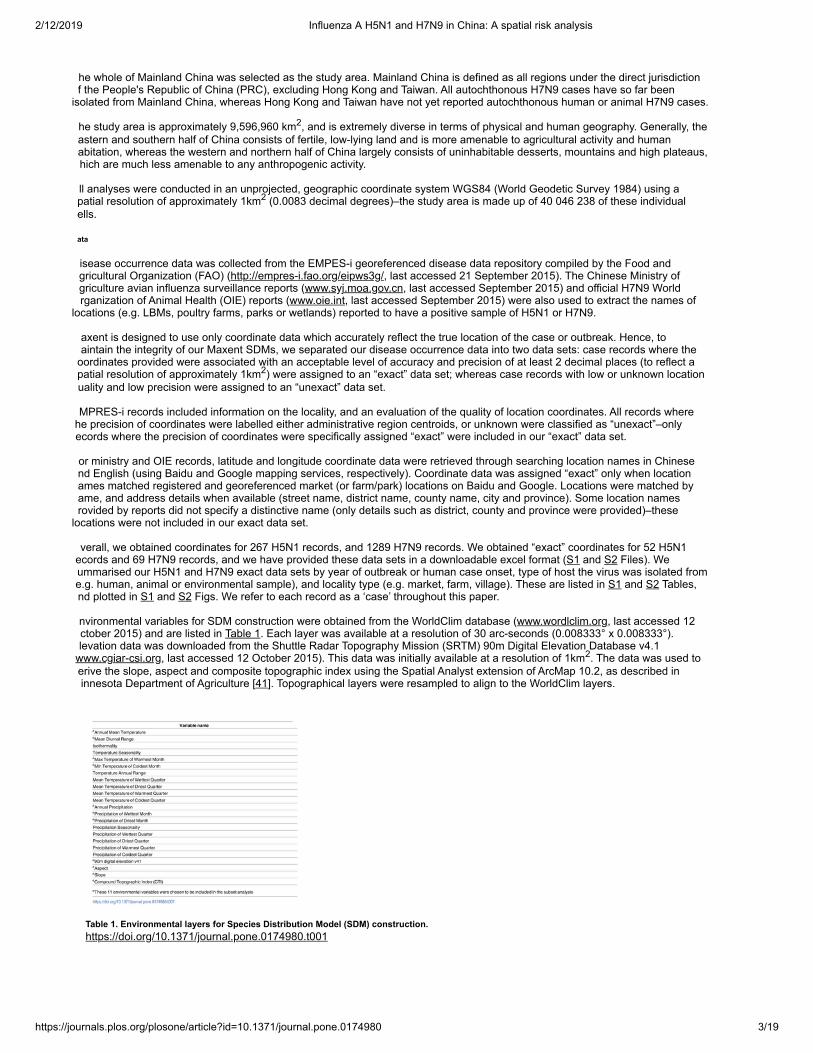
nvironmental variables for SDM construction were obtained from the WorldClim database (www.wordlclim.org, last accessed 12ctober 2015) and are listed in Table 1. Each layer was available at a resolution of 30 arc-seconds (0.008333° x 0.008333°).levation data was downloaded from the Shuttle Radar Topography Mission (SRTM) 90m Digital Elevation Database v4.1
www.cgiar-csi.org, last accessed 12 October 2015). This data was initially available at a resolution of 1km . The data was used toerive the slope, aspect and composite topographic index using the Spatial Analyst extension of ArcMap 10.2, as described ininnesota Department of Agriculture [41]. Topographical layers were resampled to align to the WorldClim layers.
Table 1. Environmental layers for Species Distribution Model (SDM) construction.https://doi.org/10.1371/journal.pone.0174980.t001
2
2
2
2
2/12/2019 Influenza A H5N1 and H7N9 in China: A spatial risk analysis
https://journals.plos.org/plosone/article?id=10.1371/journal.pone.0174980 4/19
e obtained human population data from the LandScan (2014) High Resolution global Population Data Set (copyrighted by UT-attelle, LLC, operator of Oak Ridge National Laboratory under Contract No. DE-AC05-00OR22725 with the United Statesepartment of Energy), available from (http://web.ornl.gov/sci/landscan/), last accessed October 2015. This data was originallyvailable in a resolution of 30 arc-seconds and was resampled to align to the extent of WorldClim layers. Values at each cellepresent the average or ambient human population distribution.
omestic chicken population data were obtained from Livestock Geo-Wiki (http://www.livestock.geo-wiki.org/, last accessedctober 2015), and details on data set construction were provided in Robinson et al. [42]. The authors provided separate domestichicken population rasters: (i) for chickens occupying intensive production systems (typically high density poultry holdings locatedearby urban areas) and (ii) for chickens in extensive production systems (typically low density poultry farms which have locationsmenable to prediction based on agricultural/land properties). Data was provided at a resolution of 1km and was resampled tolign to the extent of WorldClim layers. Values for each cell represented the number of birds per km . A summary of the data arerovided in S3 Table.
BM data were requested from authors of previously published SDMs [27,30]. Base maps of Chinese administrative regionsprimary and secondary) were obtained from the GADM database of Global Administrative Areas (http://www.gadm.org/, lastccessed October 2015).
pecies distribution model construction
he Maxent software package (version 3.3.3k, available from https://www.cs.princeton.edu/~schapire/maxent/) [43] was used toonstruct 8 SDMs. Maxent software [43] is primarily used in ecological sciences to model species distributions although thelgorithm has previously been used in regional and global studies of avian influenza [17,18,20,22,23,25]. Maxent uses a machine
learning algorithm to produce an estimate of the ecological suitability of a species using a set of environmental layers and a set ofccurate case coordinates [43]. It does this by fitting a probability distribution to a set of cells in a study region—it finds therobability distribution of maximum entropy (i.e. the most spread out distribution) subject to a set of environmental constraints thatepresent the species distribution [43]. For each cell in the study area, a relative environmental suitability for species presence isalculated (referred to as suitability values). Maxent consistently produces relatively accurate results, even when only small sampleizes are available (generally considered as n <100) [44–46]. A major advantage of Maxent is that it only requires presence data,aking this method more advantageous over other genetic algorithms and regression methods. Instead of prediction of presencer absence, Maxent estimates the relative environmental suitability for presence of a species, which also allow for finer estimates.dditionally, most publically available epidemiological data consist of records of human infections and animal outbreaks ascertained
rom passive surveillance, whilst systematic active surveillance using formal random sampling methodologies are not routinelyerformed with regards to AIVs—and details of negative cases or outbreaks (i.e. ‘controls’) are not made publically available.
ll environmental layers for model construction are listed in Table 1. The environmental data was included because climate factorsre known to influence AIV occurrence. Examples include modulating survival of AIV in the environment, and modifying animal hostehaviour (e.g. seasonal migration of ducks and geese) or human behaviour, or host susceptibility to infection. Observationaltudies and spatial-temporal analyses have shown AIV infections display seasonality patterns in humans and animals [47,48], solarycles for example have been associated with pandemic influenza activity [49] and animal transmission studies of human influenzairuses have shown that changes in temperature and humidity affect transmission potential and virus binding [50]. Previous studiesave also shown decreasing or increasing relative humidity influences virus stability (discussed in [50]). Ambient temperature can
impact virus transmission due to physiological changes in the hosts which increase susceptibility to infections [51], for example, inild bird species which carry LPAI AIVs transmission can increase dramatically during migratory seasons, as birds congregate in
large numbers in water bodies, and their immunity levels are likely to be low due to the physical exertion required during migration.In addition, during breeding seasons the number of immunological naïve birds increases substantially around this time, thusincreasing the amounts of AIV shed in the population [52].
emperature and precipitation can influence survivability of AIVs in the environment: H5N1 can remain infectious for 1 day at 37°C, days at 24°C and 8 weeks at 4°C in dry and wet faeces, and laboratory experiments have shown H7N9 virus stability changesith varying temperatures [53]. Also, weather variations may influence human activities—for example more people go to thearkets on a sunny day, which may increase virus transmission [54].
opographical variables (elevation, slope, aspect and composite topographic index) were also used for model construction.opographical variables, particularly elevation and slope, are commonly used in ENMs, and have been included in previous AIVodels [55]. The reasons for their inclusion were (i) they are widely available for most countries, and (ii) in some studies, they haveeen found to contribute significantly to AIV occurrence, possibly as a surrogate indicator for some unknown variable related to AIVisk [56]. Elevation is thought to relate to land coverage—for example, areas of high elevation are dominated by forests, whilst flatreas (such as plains, deltas and coastal regions) are most likely be used for agriculture or urban development [56]. Slope andspect may similarly influence AIV distribution through vegetation and land coverage. CTI is a measure for the tendency of water toool, and may indicate areas suitable for rice cropping or duck farming which have been associated with H5N1 occurrence in Asia
57]. A discussion of CTI’s influence on H5N1 transmission in Vietnam is provided in Saksena et al. [58]. Aspect values indicate theompass direction which slope faces, and can be derived from slope values [21,59].
variety of landcover and satellite data sets exist, and have been used in previous SDM models [20,22,23,25,60]. The reasoningehind their use is similar to the reasoning behind use of climate variables (they are able to capture seasonality and thus waterfowligration patterns). For our model, landcover variables and satellite data were not used as our SDMs should already account for
landcover and seasonality as they were created using precipitation, temperature and topological variables.
axent was run using Auto features. The test:training ratio was set to 40:60 as recommended by Phillips and Dudík [43]. Logisticutput formats were selected as recommended in Phillips and Dudík [43]. In logistic output formats, each cell is assigned arobability (a value between 0 and 1) which can be interpreted as the estimate of the probability of species presence or as relativeuitability. No thresholds were selected. Prevalence was set to 0.5 (default value) as we were unable to obtain reliable H5N1 and
™
22
2/12/2019 Influenza A H5N1 and H7N9 in China: A spatial risk analysis
https://journals.plos.org/plosone/article?id=10.1371/journal.pone.0174980 5/19
7N9 prevalence or detection rates for all of mainland China at high resolution. For H7N9, there is more uncertainty aroundrevalence rates as this virus is asymptomatic in birds [3]. For each study, 100 models were created and relevant outputs wereveraged.
or each virus subtype we created 4 different Maxent models which varied by number of variables and study area (modelarameter settings remained the same): Models 1–2 were built using the full set of environmental variables and the full study area;odels 3–4 were built using a subset of variables and the full study area; models 5–6 were built using the full set of variables and a
ubset of the study area; models 7–8 were built using a subset of variables and a subset of the study area.
or models 3,4,7 and 8, which included a subset of the environmental variables, 11 of the 23 environmental variables were finallyhosen to be included in the subset (similar to Sarkar et al. [16]): Annual mean temperature, mean diurnal range, maximumemperature of warmest month, minimum temperature of coldest month, annual precipitation, precipitation of wettest month,recipitation of driest month, plus the four topological variables (see Table 1).
or models 5–8, which were created using only a subset of the original geographic study area, we selected only primarydministrative regions (provinces, municipalities, autonomous regions) which had at least one H5N1 or H7N9 case (see S3 Fig),ith the following exceptions: (i) the provinces of Shaanxi, Sichuan and the Chongqing municipality don’t contain any H5N1 and7N9 cases from our exact data set however we include these provinces as they are geographically contiguous with selectedrovinces; (ii) Xinjiang Uygur autonomous region covers an expansive area, however contained only one H7N9 case and wasence excluded from the analysis. In total, 22 of 31 primary administrative regions were selected as the subset study area.
e evaluated each of the 8 models based on the receiver operating characteristic (ROC) and area under the curve (AUC) values.he ROC plot is a plot of sensitivity and 1–specificity [61]. In Maxent, sensitivity refers to how correctly the model has predictedresence, and specificity corresponds to a measure of correctly predicted absences. A model with good fit will produce a ROCurve which maximises sensitivity for low values for 1 –specificity or false positive rate. The AUC quantifies the significance of theOC, with AUC values of 0.5 indicating the model is no better than random, and a value of 1.0 indicating perfect fit. For eachodel, we averaged the testing and training AUC, and standard deviation of testing AUC, over 100 replicates.
verfitting can be an issue with maximum entropy methods, particularly when data is sparse, and can result in distributionslustering around the case data. The Maxent software has a relaxation component (regularization) which is designed to counteractorrelations. Overfitting is more likely to occur when large numbers of environmental layers are used due to correlations betweenariables. A sign of overfitting is when a model performs very well (i.e. has high AUC results on the training data set), howevererforms poorly for unseen data (i.e. for the test data set). We adopt the same methodology as Sarkar et al. [16] to test whetherodels built with the full set of environmental variables (n = 23), were suffering from overfitting. First, the difference between testnd training AUC scores was calculated for each set of 100 replicate models. Normality was tested using the Shapiro test and asot all data were normally distributed, the non-parametric Mann-Whitney-Wilcoxon test was used to decide whether the distributionf AUC differences of models with using all variables (n = 23), compared to models with fewer variables (n = 11), were identical. Alltatistical computations were performed using R.
he way environmental factors drive AIV occurrence differs according to region [22,23]. Having such a large study area (i.e. thehole of mainland China) means there is a large selection of background points, and as there are only a sparse number of diseaseases this may influence reliability of predictions [62–64]. If case data only fall into a subset of the study area, Phillips [63]ecommends a solution is to only draw background points from this subset to improve model performance. Models 5–8 wereeveloped using a subset of the original study area of mainland China, and compared to models 1–4 in terms of differences inistributions, AUC and overfitting.
isk model construction
DMs alone can only provide estimates of the probability of virus presence. In order to estimate the likelihood of zoonoticransmission, a measure of transmission efficiency must be accounted for. As described in Hill et al. [33], for zoonotic transmissiono take place, a susceptible human must be within range of an infected animal (or an animal environment contaminated by highiral shedding). The level of opportunity for human exposure from the virus is proportional to the product of the number of infectednimals and the number of susceptible humans [65]. To estimate the risk of circulating viruses to cause human infection, the SDMutputs for H5N1 and H7N9 are combined with human and animal population density. We use domestic chickens as theepresentative animal host, as these animals make up the highest proportion of China’s poultry sector [66], are the most commonly
identified animal host of H5N1 and H7N9 [67], and virus shedding occurs at a higher rate in chickens compared to other avianpecies [5].
e modify a formal risk assessment methodology described in Sarkar et al. [16]. Risk models were constructed for each virusubtype independently, whereby a value between 0 and 1 was computed for each cell representing the relative risk of a human
infection of H5N1 or H7N9 compared to other cells. These models combine ecological factors with demographic and agriculturalactors known to modulate AIV transmission, and disregard variations of risk from human interventions such as those described inhe introduction (animal biosecurity, vaccination, LBM closures etc).
or each virus subtype, we use a simple multiplicative model for computing the risk, r , for each cell k in the study area as shown inq (1).
(1)
his equation provides a measure of the risk posed to humans in cell k in regards to the likelihood of becoming infected with H5N1r H7N9. The variable, p , is the estimated prevalence of H5N1 or H7N9 in cell k (relative to other cells in the landscape) from theaxent output. The variables, h , and c , represent human and chicken population, respectively, in cell k. Computed r values were
k
kk k k

2/12/2019 Influenza A H5N1 and H7N9 in China: A spatial risk analysis
https://journals.plos.org/plosone/article?id=10.1371/journal.pone.0174980 6/19
ormalised, as shown in Eq (2), by dividing by the highest value computed over all cells, k, in the study area. The final result, R , ishe relative risk of a human infection of H5N1 or H7N9 posed to each cell:
(2)
log transformation was used for the human population density and intensive and extensive chicken population density variables,ue to their highly skewed nature. Intensive and extensive chicken population densities were summed, and treated as a singleariable, c , in the model. Both human and chicken population densities were normalized to the highest value over all cells, k, in thetudy area. A frequency histogram showing the distribution of each variable for the set of exact case locations for each virusubtype is provided in S4 Fig.
ased on the exact case data (S4 Fig) the majority of cases for both H5N1 and H7N9 fell in regions with medium human densitynd medium poultry densities, and less cases fell in low and high density regions. For chicken density this is possibly because5N1 is more likely to occur in chicken farms with poor hygiene and biosecurity practices, regardless of the size or density of the
arm. There is extreme variation in terms of biosecurity, hygiene and farming practices among chicken farms in Asia—and suchariation is difficult to account for using the chicken density data sets that are currently available [55]. Stevens et al. [31] addressedhis limitation by assuming a quadratic relationship between H5N1 risk and chicken density, with the highest risk areas being thoseith a medium density of chickens (between 500–5000 heads/km ). Their reasoning was based on a review of the literature [55],hich found that most large commercial chicken farms (where chicken densities can be very high) often implement appropriateiosecurity regulations and are expected to have little risk of H5N1 occurrence. In contrast, medium-sized poultry farmsrepresenting semi-commercial and backyard producers) are often the ones that are unregulated and have less stringent infectionontrol. Subsistence farmers with very small flock densities are considered to have negligible risk due to insufficient hosts to sustainn outbreak. For human density the explanation is less obvious. One possibility is to do with the changing food consumptionractices, which are more evident in urban areas—a literature review of food consumption practices in China found that people areoving away from the traditional practice of purchasing fresh market produce and preparing meals at home, to now eating outsidef the home (e.g. in restaurants) and eating processed foods [68]. Hence, we assume that transmission risk is lower in low humanensity areas and extremely high human density areas. There are however, no large scale surveys of consumer preferencepecifically for frozen or live poultry in China.
iven these observed relationships between the exact case locations and respective spatial variables, the human and chickenensity variables were reclassified to a scale of 0 to 1 based on a simple Gaussian fuzzy membership function prior to being used
in the risk function. This transformation is illustrated in Eq 3.
(3)
et x be the transformed (log and normalized) human or chicken population variable in cell k, and let the parameter, c, representhe ideal membership for the set and any values where x = c is assigned the value of 1. As x values move away from the midpoint,heir membership to the set gradually decreases. When x values are too distant from the ideal definition, they are no longeronsidered to be in the set and are assigned zeroes. The parameter,σ, represents the spread or width of the Gaussian function (Eq). Values of c and σ were selected for each variable based on the distribution (i.e. mean and standard deviation) of each variables
in the set of locations where exact H5N1 and H7N9 cases lie. For H5N1 we used c = 0.532 and σ = 0.183 for chicken density, and c 0.619 and σ = 0.198 for human density. For H7N9 we used c = 0.601 and σ = 0.103 for chicken density, and c = 0.689 and σ =.146 for human density. All spatial analyses were performed in ArcMap 10.2 [41].
esultspecies distribution models
ased on model evaluation results (summarised in Table 2 and Fig 1), we chose SDMs 3 and 4 (see Fig 2) to be included in ourisk model. Final SDMs 3 and 4 are shown in Fig 2, and the remaining models are shown in S5–S7 Figs. Prediction capacity wasigh for 6 of 8 models (AUC > 0.90). H7N9 SDM models (SDM 2,4,6 and 8) consistently performed better than H5N1 in terms ofUC. SDM models 1–2, suffered from overfitting based on Mann-Whitney-Wilcoxon tests (P-values turned out to be less than theignificance level, hence the null hypothesis is rejected and AUC differences are non-identical). However overfitting was not an
issue for SDMs 5–6. Reducing the study area (SDMs 5–8) did not make considerable differences in terms of suitability distributionsee S6 and S7 Figs), or AUC results (see Table 2). The term “suitability distribution” refers to the distribution of these suitabilityalues in geographic space. For each subtype, the suitability for occurrence is displayed on a continuous scale from 0 (leastuitable) to 1 (highly suitable). On visual appraisal, all 4 H5N1 suitability distributions were similar to each other; likewise, all 47N9 suitability distributions were similar. H5N1 suitability distribution was distinctly more geographically diffuse across south-astern China, whereas H7N9 suitability distribution was clustered densely around distinct areas (Zhejiang and Guangdongrovinces). For H5N1, 5.8% (3 of 52) exact cases fell into low suitability areas (p <0.25), and for H7N9, 8.7% (6 of 69) exact cases
ell into the low suitability areas (p <0.25).
k
k
2
kk

2/12/2019 Influenza A H5N1 and H7N9 in China: A spatial risk analysis
https://journals.plos.org/plosone/article?id=10.1371/journal.pone.0174980 7/19
Fig 1. Species Distribution Model (SDMs) evaluation results.Top left panel shows boxplots of the area under the curve (AUC) for test data. The top right panel shows boxplots of AUC fortraining data. The bottom left panel shows boxplots of standard deviation of test data. The bottom right panel shows boxplotsof test and training AUC differences.https://doi.org/10.1371/journal.pone.0174980.g001
Fig 2. Species Distribution Models (SDMs) built using Maxent.The first panel shows H5N1 (SDM 3) and the second panel shows H7N9 (SDM 4). Suitability values for each cell(approximately 1km ) are represented on a continuous scale of low (light grey) to high (dark grey). SDMs were built usingMaxent software version 3.3.3k (available from https://www.cs.princeton.edu/~schapire/maxent/). SDMs were developedusing environmental variables, created using data from: the WorldClim database (www.wordlclim.org), the Shuttle RadarTopography Mission (SRTM) 90m Digital Elevation Database v4.1 (www.cgiar-csi.org). Data sources used to obtain the caselocations to build SDMs include: the Food and Agricultural Organization (FAO) (http://empres-i.fao.org/eipws3g/), the ChineseMinistry of Agriculture Avian Influenza Surveillance Reports (www.syj.moa.gov.cn), the World Organization of Animal Health(OIE) reports (www.oie.int). Base maps were obtained from the GADM database of Global Administrative Areas(http://www.gadm.org/). Maps were built using ArcMap 10.2.https://doi.org/10.1371/journal.pone.0174980.g002
Table 2. Species Distribution Model (SDM) evaluation results.https://doi.org/10.1371/journal.pone.0174980.t002
isk analysis
2

2/12/2019 Influenza A H5N1 and H7N9 in China: A spatial risk analysis
https://journals.plos.org/plosone/article?id=10.1371/journal.pone.0174980 8/19
aps representing the results from this risk analysis are presented in Fig 3. For each subtype, the estimated relative risk of humaninfection, for each cell (approximately 1km ) is represented on a continuous scale from 0 (least risk) to 1 (highest risk) indicated bylevel of grey shading. H5N1 high risk areas were more diffusely spread around the south-eastern quarter of China, primarily in
reas surrounding the Yangtze River delta. H5N1 high risk areas extended towards the Sichuan Basin, Jianghan Plain, riveregions of Tibet, and Qinghai lake, as well as plains in Inner Mongolia, Shaanxi, Hebei and Henan. H7N9 high risk areas were moreoncentrated to the south-eastern coast line starting from Shandong and extended south towards Guangxi, encompassing nearlyll of Jiangsu and Shanghai, and plains in Zhejiang, Anhui, Jiangxi, Hunan and Hubei, and Guangdong provinces.
Fig 3. Risk models.The first panel shows H5N1 and the second panel shows H7N9. Final relative risk values for each cell (approximately 1km )are represented on a continuous scale of low (light grey) to high (dark grey). Data sources used to develop risk modelsinclude: species distribution models (SDMs) 3 and 4 which were produced in this study, domestic chicken population dataobtained from Livestock Geo-Wiki (http://www.livestock.geo-wiki.org/), human population data from the LandScan (2014)High Resolution global Population Data Set (http://web.ornl.gov/sci/landscan/). Base maps were obtained from the GADMdatabase of Global Administrative Areas (http://www.gadm.org/). Maps were built using ArcMap 10.2.https://doi.org/10.1371/journal.pone.0174980.g003
or each subtype, to validate the performance of our risk model, we extracted normalised relative risk values R at exact caselocations and observed where these points fell on a risk scale of low (0.0 > R ≥ 0.25), low-medium (0.25 > R ≥ 0.50), medium-
igh (0.5 > R ≥ 0.75) and high (0.75 > R ≥ 1.0). In Fig 4, for each subtype, we display the number of exact cases which fell intoach of the four categories. The left chart shows categorisation of H5N1 exact case locations corresponding to the H5N1 riskodel. The right chart shows categorisation of H7N9 exact case locations corresponding to the H7N9 risk model. For exact H5N1
ases, 7.7% (4/52) of points fell in the low risk category, 30.8% (16/52) of points fell in the low-medium risk category, 36.5% (19/52)f points fell in the medium-high risk category and 25.0% (13/52) of points fell in the high risk category. For exact H7N9 cases,.82% (6/68) of points fell in the low risk category, 13.2% (9/68) of points fell in the low-medium risk category, 44.1% (30/68) ofoints fell in the medium-high risk category and 33.8% (23/68) of points fell in the high risk category. Based on these results, the7N9 risk model fitted more to our data set than H5N1. Human population data from LandScan (2014) for China had the smallest
aster extent, hence our final risk analysis models were clipped to match this extent. One exact H7N9 case did not fall within thisxtent and hence was excluded from validation tests.
Fig 4. Risk model validation.Charts show the number of exact case locations which fell into a low risk area (0.0 > R ≥ 0.25), low-medium risk area (0.25 >R ≥ 0.50), medium-high risk area (0.5 > R ≥ 0.75) and high risk area (0.75 > R ≥ 1.0). The left chart shows categorisation ofH5N1 exact case locations corresponding to the H5N1 risk model. The right chart shows categorisation of H7N9 exact caselocations corresponding to the H7N9 risk model.https://doi.org/10.1371/journal.pone.0174980.g004
2
2
™
kk k
k k
™
kk k k

2/12/2019 Influenza A H5N1 and H7N9 in China: A spatial risk analysis
https://journals.plos.org/plosone/article?id=10.1371/journal.pone.0174980 9/19
e additionally validated our risk model using unexact locations of H5N1 and H7N9 cases, however as we don't know the exactlocation for the unexact cases, we recorded the maximum R within a 5km radius of each unexact case (see S8 Fig). For H5N1,
0.9% (45/215) of points fell in the low risk category, 13.4% (29/215) of points fell in the low-medium risk category, 37.2% (80/215)f points fell in the medium-high risk category and 28.3% (61/215) of points fell in the high risk category. For H7N9 15.3%187/1221) of points fell in the low risk category, 21.5% (262/1221) of points fell in the low-medium risk category, 39.7% (485/1221)f points fell in the medium-high risk category and 23.5% (287/1221) of points fell in the high risk category.
inal relative risk values, R were aggregated across all secondary administrative areas (prefectures, municipalities, cities) touantify the relative risk posed to a particular area. The mean value per area was taken as the aggregated relative risk value. Highisk areas were considered as those with a mean > 0.5 and are highlighted in Fig 5. For H5N1, these areas included: Foshan,hongshan, Dongguan, Zhanjiang (Guangdong); Beihai (Guangxi); Ezhou, Wuhan (Hubei); Nanchang (Jiangxi); Nanjing (Jiangsu);efei (Anhui); Xiangtan (Hunan); and Haikou (Hainan). For H7N9, these areas included: Shanghai municipality, Jiaxing, Zhoushan
Zhejiang); Foshan, Zhongshan, Shantou, Dongguan (Guangdong); Changzhou, Nantong, Suzhou, Wuxi, Taizhou, Zenjiang,angzhou, Nanjing (Jiangsu), Ma’anshan, Wuhu, Tongling, Chaohu (Anhui); Beihai (Guangxi); Ezhou (Hubei); and NanchangJiangxi).
Fig 5. High risk areas.The first panel shows H5N1 and the second panel shows H7N9. Final relative risk values for each cell (approximately 1km )are represented on a continuous scale of low (light grey) to high (dark grey). High risk areas (1) represent secondaryadministrative areas (prefectures, municipalities, cities) areas with a mean-aggregated relative risk value (> 0.5), and high riskareas (2) are those areas which have not yet reported a case. Data sources used to develop risk models include: speciesdistribution models (SDMs) 3 and 4 which were produced in this study, domestic chicken population data obtained fromLivestock Geo-Wiki (http://www.livestock.geo-wiki.org/), human population data from the LandScan (2014) High Resolutionglobal Population Data Set (http://web.ornl.gov/sci/landscan/). Base maps of Chinese administrative regions were obtainedfrom the GADM database of Global Administrative Areas (http://www.gadm.org/). Maps were built using ArcMap 10.2.https://doi.org/10.1371/journal.pone.0174980.g005
e also highlighted high risk areas which have not yet reported a H5N1 or H7N9 case (High risk areas (1) in Fig 5). An area isonsidered to have a H5N1 or H7N9 case if an exact or unexact case fell within the area. For H5N1 these included: Dongguang,oshan and Zhongshan (Guangdong); Beihai (Guangxi); and Haikou (Hainan). For H7N9 these included: Beihai (Guangxi) andhoushan (Zhejiang). The computed risk map can also be downloaded from S3 and S4 Files in ASCII format.
In previous SDMs, LBM density showed strong associations with H7N9 [27,28,30] and H5N1 [30]. LBMs are locations where AIVransmission can be especially amplified due to the mixing of chickens from different farms, overcrowding, and stressful (and thusimmunosuppressive) poultry housing conditions. Inclusion of this variable into the risk analysis would account for the highransmission intensity seen in LBM environments.
e were able to collect LBM data (from [27,30], previously purchased from a commercial mapping provider www.autonavi.com),owever data collection methods were not available for scrutiny. Due to uncertainties regarding reliability and validity of this dataet, we did not incorporate a LBM variable into the formal risk model. Instead, we presented our risk models overlayed with LBMata aggregated to secondary administrative areas (see Fig 6). LBM data was only available for 43 (of 344) prefectures,unicipalities and cities within 10 (of 31) provinces in China. Only 10 (of 52) H5N1 exact points and 45 (of 69) H7N9 exact points
ell into these regions. Secondary administrative areas with highest LBM counts included Jiaxing (Zhejiang), Beijing, GuangzhouGuangdong) and Shanghai.
k
k’
2
™

2/12/2019 Influenza A H5N1 and H7N9 in China: A spatial risk analysis
https://journals.plos.org/plosone/article?id=10.1371/journal.pone.0174980 10/19
Fig 6. Risk models overlayed with live bird market density.The first panel shows H5N1 and the second panel shows H7N9. Final relative risk values for each cell (approximately 1km )are represented on a continuous scale of low (light grey) to high (dark grey). Different sized circles represent the live birdmarket density per secondary administrative areas (prefectures, municipalities, cities), however data were only available for43 (of 344) of these areas. Data sources used to develop risk models include: species distribution models (SDMs) 3 and 4which were produced in this study, domestic chicken population data obtained from Livestock Geo-Wiki(http://www.livestock.geo-wiki.org/), human population data from the LandScan (2014) High Resolution global PopulationData Set (http://web.ornl.gov/sci/landscan/). Live bird market data were requested from authors of previously published SDMs[27,30]. Base maps of Chinese administrative regions were obtained from the GADM database of Global Administrative Areas(http://www.gadm.org/). Maps were built using ArcMap 10.2.https://doi.org/10.1371/journal.pone.0174980.g006
iscussionIn this study, we (i) developed a refined data set of H5N1 and H7N9 locations with consideration of animal/animal environment case
ata as well as spatial accuracy and precision of coordinates; (ii) used this data set along with environmental variables in Maxent touild SDMs for each subtype in high resolution spatial units of 1km cells; (iii) developed a risk analysis framework, which
integrated Maxent models with human and chicken population density to estimate the geographic risk of zoonotic transmission of5N1 and H7N9; and (iv) identified areas of China at high risk of H5N1 and H7N9 transmission differentiated into two groups, those
hat have and have not yet reported cases.
rom our risk models, areas at high risk of both H5N1 and H7N9 transmission were identified along the south-eastern coast startingrom Shandong province and extended south towards Guangxi province. These areas include traditional rice-duck farming areas ofuzhou and Hangzhou city (Zhejiang), and communities around Taihu lake and Qiantang river [28], traditional rice-duck farmingystems create an ideal environment for AIV dissemination because of the mixing of semi-domestic and wild duck hosts which arehe traditional carriers of AIVs [8]. Duck farming systems exist widely in villages in coastal southern areas [37,69] and are knownigh risk areas for AIV transmission [28,70,71]. Inland, both H5N1 and H7N9 risk models demonstrate high risk in areasurrounding the Yangtze River delta, including its major tributaries such as Dongting Lake and Poyang Lake. These are migratoryird resting sites, and are also known high risk areas for AIV transmission [8]. Our risk models appropriately do not estimate highisk in large expanses of uninhabitable regions that cannot support maintenance of virus (e.g. expansive deserts in Inner Mongolia,ibet and Xinjiang autonomous regions as identified in Fang et al. [71]).
he final H5N1 and H7N9 risk models differed in terms of their respective geographic profiles, and in terms of performance. Foroth subtypes, high risk areas of transmission were identified in mainly south-eastern China, with H5N1 distribution extending more
inland into Jiangxi province. These results were consistent with Li et al. [72] (the only other study to build H5N1 and H7N9 modelssing comparable means). Both H5N1 and H7N9 risk models showed reasonable predictive capacity, with the majority of exactoints falling into high and medium-high risk areas (61.5% for H5N1 and 77.9% for H7N9). However fewer points fell into high riskategories (25% for H5N1 and 33.8% for H7N9). The predictive capacity for the H5N1 risk model was lower for the H7N9 model,
likely due to the influence of the p value (i.e. the suitability value).
espite potential sampling biases, and a relatively small number of case data, we produced high performing SDMs (6 of 8 modelsith AUC > 0.9) which are similar to previous H5N1 [31,37] and H7N9 SDMs [24–30]. In all our SDMs, H7N9 consistently showedigher AUC results compared to H5N1, suggesting H7N9 suitability models could be better explained by seasonality and landoverage. This could be associated with the differences in H7N9 and H5N1 temporal distributions: H7N9 exhibits high seasonalitycases consistent peaking around January to February), whereas H5N1 exhibits a more sporadic distribution pattern [3].
he seasonal pattern of H7N9 is thought to be correlated to increases in poultry stock and sales during Chinese New Yearestivities [73] however, this would not be implicit to only one AIV subtype. Alternatively, there is also a likely difference in theompleteness of our H5N1 and H7N9 case datasets. For H5N1, most exact records were drawn from unknown location types (17f 52) whereas for H7N9, most (54 of 69) exact H7N9 cases were obtained from LBMs where most H7N9 zoonotic transmission
akes place. Our exact H7N9 cases were mostly concentrated in Guangdong (20 of 29) and Zhejiang (11 of 69) whereas H5N1
2
™
2
k

2/12/2019 Influenza A H5N1 and H7N9 in China: A spatial risk analysis
https://journals.plos.org/plosone/article?id=10.1371/journal.pone.0174980 11/19
ases are more evenly spread across the 17 primary administrative areas. Our H5N1 exact records were evenly distributedemporally with most cases (30 of 52) being drawn from 2004 and 2014, however we would expect to find more H5N1 cases in theears before widescale vaccination campaigns in poultry from 2004 to 2008. The time lag between the emergence of H5N1 and7N9 means that H7N9 case reporting and identification is likely to be more complete, due to advances in AIV control andurveillance capabilities and technologies over the years.
here is likely increased transmission intensity within LBMs, hence LBM density would be an important parameter to include in ourisk model. However, we were unable to ascertain how collection of LBM locations was performed and whether sampling biasontributed significantly to higher LBM densities in Jiaxing (Zhejiang), Beijing, Guangzhou (Guangdong) and Shanghai. From aimple visual appraisal, areas of high risk of H5N1 and H7N9 fell into areas where there are high numbers of LBM with thexception of Beijing. Isolations of H5N1 and H7N9 have been infrequent in Beijing, it is likely that the high density of LBMs found in
his region is possibly due to data collection being more easily performed in the major cities (however we were unable to ascertainow the data collection was performed).
ur risk model aimed to identify specific geographic areas of high risk—however there are other modelling methodologies whichxplicitly model disease spread within populations. A commonly used example is the dynamical epidemic SIR model, which usesrdinary differential equations to forecast how host populations transition through biologically relevant disease states (e.g.usceptible, Infectious, Recovered) over a time period [65]. In contrast to our study, these models are able to provide an indicationf whether the disease is capable of sustaining itself in a human population (indicated when a computed basic reproduction numberR ) >1), and also evaluate effectiveness of public health interventions. However many of these studies don’t distinguish theiffering risks inherent in different geographic areas at particularly high resolutions [74–78]. Typically, only spatial resolutions at theountry or province level are used.
In Li et al. [77], the authors aggregated their model into two spatial regions which encapsulated multiple provinces e.g. the southernegion included Guangdong, Fujian and Hunan provinces, and the eastern region included Jiangsu, Zhejiang, Shanghai and Anhuirovinces. They estimated the transmission potential of H7N9 among chicken flocks and found differences between the two regions
—in the eastern region, initial chicken host susceptibility decreased over time, but in the southern region susceptibility remainedtable. In our study, we showed that most medium-high and high risk regions for H7N9 were primarily in eastern provinces (6/24),ompared to the southern provinces (16/24), with a few medium-high and high risk regions identified inland (n = 2). We foundelative risk values were overall higher in eastern provinces (mean R of Jiangsu, Zhejiang, Shanghai and Anhui provinces rangedrom 0.24 to 0.72) compared to southern provinces (mean R of Guangdong, Fujian and Hunan provinces ranged from 0.11 to.23). Future works could attempt to integrate both dynamical models with spatial risk models to take into account both diseaseynamics and inherent geographic heterogeneity.
ovel methods which use the SIR framework to quantify the spatial pattern transitions of disease spread are currently being studieddescribed in detail in [79,80]). For example, Li [79] describes the phenomenon of patch invasion, which can be determined usingusceptible-infectious host dynamics, and like the R , can indicate whether a disease will maintain itself in isolated geographicistributions as opposed to spreading into other geographic regions. Further development of such methodologies would be useful
o consider in future spatial models of epidemics.
his study is subject to certain limitations, which are discussed in detail below.
1. A bias for AIV reporting may occur because areas of high human density often have more resources to implement active and passive surveillance of AIV.Thus, our models may have overestimated the risk posed to areas with high human density. This may also partially explain why our SDMs and risk models,which include a human population variable, are highly similar. Likewise, there is a known paucity of AIV surveillance in more uninhabitable areas of northernand western China—hence our SDMs may have underestimated risk in these areas. Herrick et al. [59] solely identify the entire north-eastern corner to havehigh AIV suitability, albeit their study focused only on AIV in wild bird hosts.
2. The range of possible virus hosts for AIVs is uncertain; e.g., H5N1 has occasionally been identified in wild ducks, geese and swans, while H7N9 has not yetbeen identified in wild birds. In this study we did not conduct separate analyses by host type due to limitations in available data, i.e., this would result in too fewcases (see S1 and S2 Tables for breakdowns of animal host). Therefore, our study did not take into consideration the differences in habitat suitability for thewide range of AIV host species (e.g. domestic poultry, domestic ducks, wild ducks and geese, humans and other potential carriers of AIV), nor the differencesin virus shedding and transmission in different host species [5].
3. There are limitations inherent in resampling and manipulation of the chicken and human density data sources. As described in Feng et al. [81], logtransformation of original data precludes our ability to make inferences regarding the original data.
4. Species distribution models inherently only predict probable presence or absence, and do not predict species abundance. Abundance of H5N1 and H7N9 inavian populations is considered to be extremely low as determined in a previous meta-analysis of H5N1 and H7N9 surveillance studies [6]. In incidental hosts(i.e. human populations) and the environment, prevalence is expected to be much lower. As such, our risk models may have over-estimated actual risk.
5. Our analysis only accounted for the risk of autochthonous AIV transmission. Risk of infection can also occur through human travel and poultry trading.
6. Limitations inherent in this risk assessment methods are similar to those described for MCDA [32,82], which include (i) overweighing variables fromcorrelations between different environmental variables, and correlations between environmental and population variables, and (ii) subjectivity in the selectionof variables, formulation of risk equation and selection of fuzzy membership functions and parameters.
7. Our risk analysis implied that domestic chickens are the sole animal population responsible for AIV transmission even though both H5N1 and H7N9 have beenrecognised in various other avian and mammalian species. Our rationale for focusing on chickens is described in the methods section above. We chose toexclude duck density because in some China-only models, duck density had either not been used as a distinct variable [27,30], or when used, was notdeemed an important contributor [28]. While it is likely that domestic duck density also contributes to the spread of H5N1, limited disease occurrence data(outbreak data rather than active surveillance data) makes it difficult to accurately model its impact [37].
8. This analysis did not consider certain transmission dynamics which are important in the disease cycle. Transmission efficiency is modulated by the degree andstrength of contact between poultry and humans, as well as the inherent (i.e. genetic) efficiency of the virus to attach and replicate in humans. The level ofanimal handling, personal protection (e.g. masks, gloves), or biosecurity measures are currently not collected on a large scale; thus accounting for such
0
kk
0

2/12/2019 Influenza A H5N1 and H7N9 in China: A spatial risk analysis
https://journals.plos.org/plosone/article?id=10.1371/journal.pone.0174980 12/19
transmission dynamics was beyond the scope of this paper. In addition, while there are certain genetic mutations known to promote attachment and replicationto human cells, computationally incorporating these genetic influences into our risk model was also beyond the scope of this study.
9. Our study did not take into account the wide range of competing AIV subtypes, nor did it differentiate between strains within a subtype.
onclusion5N1 and H7N9 subtypes have persisted in animal hosts and continue to cause human infections since their emergence in China.dditionally, novel zoonotic AIVs (such as H10N8 and H5N6) have also emerged in mainland China, and human infections from
hese subtypes have so far been restricted to China. Furthermore, surveillance of poultry reveals there are many new reassortantIVs being discovered [83,84]. Hence, zoonotic avian influenza poses a major risk to China.
s outlined previously in the introduction, the motivation for this study was to identify specific areas to target and trial controleasures which cannot be implemented on a large scale due to cost or public disapproval. Quantifiable reductions of H7N9 human
ases and AIV environmental samples have already been demonstrated following closure of LBMs in cities in GuangzhouGuangdong); Shanghai; Hangzhou, Huzhou (Zhejiang); and Nanjing (Jiangsu) [85–90]. Peiris et al. [91] provide an extensiveiscussion of practical measures that can be made (temporary LBM rest days, removing live poultry from holdings overnight,eparating aquatic poultry from gallinaceous poultry, centralised slaughtering of poultry), we recommend implementing theseontrol measures in the high risk secondary administrative areas identified in our H5N1 and H7N9 risk models: Foshan,hongshan, Shantou, Dongguan, Zhanjiang (Guangdong); Beihai (Guangxi); Wuhan, Ezhou (Hubei); Nanchang (Jiangxi);a’anshan, Wuhu, Tongling, Chaohu, Hefei (Anhui); Xiangtan (Hunan); Jiaxing, Zhoushan (Zhejiang); Changzhou, Nantong,uzhou, Wuxi, Taizhou, Zenjiang, Yangzhou (Jiangsu); and Haikou (Hainan). The results from the risk models provide high
esolution risk projections, which allow appreciable discrimination of higher risk areas within these regions (available for download:3 and S4 Files) to further target implementation of control measures.
DMs are advantageous over simple mapping techniques, as they provide a spatially continuous estimate of disease presence,nd are able to identify areas at risk of transmission where cases have not previously been recognised. A reliable risk model caneduce the need for expensive, large-scale surveillance programs to identify high risk areas. Our study finds differences in theeographic distribution and performance of H5N1 and H7N9 SDMs suggesting there may be intrinsic differences in how the novel7N9 survives in the environment. We suggest future research focus on comparing H5N1 and H7N9 prevalence rates andurvivability in the natural environment to develop a better understanding of environmental transmission in human infection.
upporting information1 Fig. Exact H5N1 cases: spatial distribution in China.irst panel indicates distribution by year, middle panel indicates distribution by type of host, last panel indicates type of location.hinese provinces are outlined in grey. Data sources used to obtain the case locations include: the Food and Agriculturalrganization (FAO) (http://empres-i.fao.org/eipws3g/), the Chinese Ministry of Agriculture Avian Influenza Surveillance Reports
www.syj.moa.gov.cn), the World Organization of Animal Health (OIE) reports (www.oie.int). Base maps were obtained from theADM database of Global Administrative Areas (http://www.gadm.org/). Maps were built using ArcMap 10.2.ttps://doi.org/10.1371/journal.pone.0174980.s001TIF)
2 Fig. Exact H7N9 cases: spatial distribution in China.irst panel indicates distribution by year, middle panel indicates distribution by type of host, last panel indicates type of location.hinese provinces are outlined in grey. Data sources used to obtain the case locations include: the Food and Agriculturalrganization (FAO) (http://empres-i.fao.org/eipws3g/), the Chinese Ministry of Agriculture Avian Influenza Surveillance Reports
www.syj.moa.gov.cn), the World Organization of Animal Health (OIE) reports (www.oie.int). Base maps were obtained from theADM database of Global Administrative Areas (http://www.gadm.org/). Maps were built using ArcMap 10.2.ttps://doi.org/10.1371/journal.pone.0174980.s002TIF)
3 Fig. Sub-selection of provinces for species distribution models 5–8.ap showing the 22 (of 31) primary administrative regions (provinces, municipalities, autonomous regions) selected as the studyrea in constructing SDM 5–8 (in grey). Base maps were obtained from the GADM database of Global Administrative Areashttp://www.gadm.org/). Maps were built using ArcMap 10.2.ttps://doi.org/10.1371/journal.pone.0174980.s003TIF)
4 Fig. Risk analysis variables.op row c values at cells enclosing H5N1 and H7N9 exact points; bottom row h values at cells enclosing H5N1 and H7N9 exactoints.ttps://doi.org/10.1371/journal.pone.0174980.s004TIF)
5 Fig. Species distribution models 1–2.he first panel shows H5N1 (SDM 1) and the second panel shows H7N9 (SDM 2). Suitability values for each cell (approximatelykm ) are represented on a continuous scale of low (light grey) to high (dark grey). SDMs were built using Maxent software version.3.3k (available from https://www.cs.princeton.edu/~schapire/maxent/). SDMs were developed using environmental variables,reated using data from: the WorldClim database (www.wordlclim.org), the Shuttle Radar Topography Mission (SRTM) 90m Digitallevation Database v4.1 (www.cgiar-csi.org). Data sources used to obtain the case locations to build SDMs include: the Food andgricultural Organization (FAO) (http://empres-i.fao.org/eipws3g/), the Chinese Ministry of Agriculture Avian Influenza Surveillanceeports (www.syj.moa.gov.cn), the World Organization of Animal Health (OIE) reports (www.oie.int). Base maps were obtained
rom the GADM database of Global Administrative Areas (http://www.gadm.org/). Maps were built using ArcMap 10.2.
k k
2

2/12/2019 Influenza A H5N1 and H7N9 in China: A spatial risk analysis
https://journals.plos.org/plosone/article?id=10.1371/journal.pone.0174980 13/19
ttps://doi.org/10.1371/journal.pone.0174980.s005TIF)
6 Fig. Species distribution models 5–6.he first panel shows H5N1 (SDM 5) and the second panel shows H7N9 (SDM 6). Suitability values for each cell (approximatelykm ) are represented on a continuous scale of low (light grey) to high (dark grey). SDMs were built using Maxent software version.3.3k (available from https://www.cs.princeton.edu/~schapire/maxent/). SDMs were developed using environmental variables,reated using data from: the WorldClim database (www.wordlclim.org), the Shuttle Radar Topography Mission (SRTM) 90m Digitallevation Database v4.1 (www.cgiar-csi.org). Data sources used to obtain the case locations to build SDMs include: the Food andgricultural Organization (FAO) (http://empres-i.fao.org/eipws3g/), the Chinese Ministry of Agriculture Avian Influenza Surveillanceeports (www.syj.moa.gov.cn), the World Organization of Animal Health (OIE) reports (www.oie.int). Base maps were obtained
rom the GADM database of Global Administrative Areas (http://www.gadm.org/). Maps were built using ArcMap 10.2.ttps://doi.org/10.1371/journal.pone.0174980.s006TIF)
7 Fig. Species distribution models 7–8.he first panel shows H5N1 (SDM 7) and the second panel shows H7N9 (SDM 8). Suitability values for each cell (approximatelykm ) are represented on a continuous scale of low (light grey) to high (dark grey). SDMs were built using Maxent software version.3.3k (available from https://www.cs.princeton.edu/~schapire/maxent/). SDMs were developed using environmental variables,reated using data from: the WorldClim database (www.wordlclim.org), the Shuttle Radar Topography Mission (SRTM) 90m Digitallevation Database v4.1 (www.cgiar-csi.org). Data sources used to obtain the case locations to build SDMs include: the Food andgricultural Organization (FAO) (http://empres-i.fao.org/eipws3g/), the Chinese Ministry of Agriculture Avian Influenza Surveillanceeports (www.syj.moa.gov.cn), the World Organization of Animal Health (OIE) reports (www.oie.int). Base maps were obtained
rom the GADM database of Global Administrative Areas (http://www.gadm.org/). Maps were built using ArcMap 10.2.ttps://doi.org/10.1371/journal.pone.0174980.s007TIF)
8 Fig. Risk model validation for all cases using aggregated relative risk values.umber of all (unexact and exact) points per risk category (low 0.0–0.25; low-medium 0.25–0.50; medium-high 0.50–0.75; high.75–1.00). For each point, the maximum 1km cell relative risk value within approximately 5km radius was taken as the aggregatedelative risk value.ttps://doi.org/10.1371/journal.pone.0174980.s008TIF)
1 Table. Summary of H5N1 exact locations.ttps://doi.org/10.1371/journal.pone.0174980.s009DOCX)
2 Table. Summary of H7N9 exact locations.ttps://doi.org/10.1371/journal.pone.0174980.s010DOCX)
3 Table. Summary of variables used in risk analysis.ttps://doi.org/10.1371/journal.pone.0174980.s011DOCX)
1 File. Data set of exact H5N1 case locations.ach entry represents a case location which we considered an ‘exact’ case location. For each entry, we provide the source of
information, and information associated with the case e.g. latitude and longitude coordinates, date associated with poultry outbreakr human case, the host species associated with the sample.ttps://doi.org/10.1371/journal.pone.0174980.s012CSV)
2 File. Data set of exact H7N9 case locations.ach entry represents a case location which we considered an ‘exact’ case location. For each entry, we provide the source of
information, and information associated with the case e.g. latitude and longitude coordinates, date associated with poultry outbreakr human case, the host species associated with the sample.ttps://doi.org/10.1371/journal.pone.0174980.s013CSV)
3 File. H5N1 risk assessment map.inal computed H5N1 relative risk values for each cell (approximately 1km ) in China in ASCII format.ttps://doi.org/10.1371/journal.pone.0174980.s014ZIP)
4 File. H7N9 risk assessment map.inal computed H7N9 relative risk values for each cell (approximately 1km ) in China in ASCII format.ttps://doi.org/10.1371/journal.pone.0174980.s015ZIP)
cknowledgments
2
2
2
2

2/12/2019 Influenza A H5N1 and H7N9 in China: A spatial risk analysis
https://journals.plos.org/plosone/article?id=10.1371/journal.pone.0174980 14/19
1.
2.
3.
View Article PubMed/NCBI Google Scholar
4.
View Article PubMed/NCBI Google Scholar
5.
View Article PubMed/NCBI Google Scholar
6.
View Article Google Scholar
7.View Article Google Scholar
8.View Article PubMed/NCBI Google Scholar
9.
View Article PubMed/NCBI Google Scholar
10.View Article Google Scholar
11.
View Article Google Scholar
12.
View Article PubMed/NCBI Google Scholar
e acknowledge the National Health and Medical Research Council (NHMRC), project grant number APP1082524. The contentsf the published material are solely the responsibility of the individual authors and do not reflect the views of the NHMRC.
uthor ContributionsConceptualization: RM.
Data curation: CMB LG SS.
Formal analysis: CMB LG SS.
Funding acquisition: RM.
Investigation: CMB LG SS.
Methodology: CMB LG SS.
Project administration: RM.
Resources: RM.
Software: CMB LG SS.
Supervision: RM.
Validation: CMB LG SS.
Visualization: CMB LG SS.
Writing – original draft: CMB.
Writing – review & editing: CMB RM LG SS.
eferencesWorld Health Organization (WHO) (2016) Cumulative number of confirmed human cases of avian influenza A(H5N1) reported to WHO (19 July 2016).
Food and Agricultural Organisation of the United Nations (FAO) (2016) H7N9 situation update—20 July 2016.
Bui C, Bethmont A, Chughtai AA, Gardner L, Sarkar S, Hassan S, et al. (2016) A Systematic Review of the Comparative Epidemiology of Avian andHuman Influenza A H5N1 and H7N9—Lessons and Unanswered Questions. Transbound Emerg Dis 63: 602–620. pmid:25644240
Bethmont A, Bui CM, Gardner L, Sarkar S, Chughtai AA, Macintyre CR (2016) Quantified degree of poultry exposure differs for human cases of avianinfluenza H5N1 and H7N9. Epidemiol Infect 144: 2633–2640. pmid:27267621
Pantin-Jackwood MJ, Miller PJ, Spackman E, Swayne DE, Susta L, Costa-Hurtado M, et al. (2014) Role of Poultry in the Spread of Novel H7N9 InfluenzaVirus in China. J Virol 88: 5381–5390. pmid:24574407
Bui C, Rahman B, Heywood AE, MacIntyre CR (2016) A Meta-Analysis of the Prevalence of Influenza A H5N1 and H7N9 Infection in Birds. TransboundEmerg Dis: n/a–n/a.
Fournié G, Pfeiffer DU (2014) Can closure of live poultry markets halt the spread of H7N9? The Lancet 383: 496–497.
Sims L, Jeggo M (2014) Avian influenza from an ecohealth perspective. Ecohealth 11: 4–14. pmid:24763945
Peiris JSM, Cowling BJ, Wu JT, Feng L, Guan Y, Yu H, et al. (2016) Interventions to reduce zoonotic and pandemic risks from avian influenza in Asia. TheLancet Infectious Diseases 16: 252–258. pmid:26654122
Elith J, Phillips SJ, Hastie T, Dudík M, Chee YE, Yates CJ (2011) A statistical explanation of MaxEnt for ecologists. Diversity and Distributions 17: 43–57.
Golding N, Purse BV, Warton D (2016) Fast and flexible Bayesian species distribution modelling using Gaussian processes. Methods in Ecology andEvolution 7: 598–608.
Wardrop NA, Geary M, Osborne PE, Atkinson PM (2014) Interpreting predictive maps of disease: highlighting the pitfalls of distribution models inepidemiology. Geospatial health 9: 237. pmid:25545941

2/12/2019 Influenza A H5N1 and H7N9 in China: A spatial risk analysis
https://journals.plos.org/plosone/article?id=10.1371/journal.pone.0174980 15/19
13.
View Article PubMed/NCBI Google Scholar
14.
View Article Google Scholar
15.
View Article PubMed/NCBI Google Scholar
16.
View Article Google Scholar
17.View Article Google Scholar
18.
View Article PubMed/NCBI Google Scholar
19.
View Article PubMed/NCBI Google Scholar
20.
View Article PubMed/NCBI Google Scholar
21.
View Article Google Scholar
22.
View Article PubMed/NCBI Google Scholar
23.
View Article PubMed/NCBI Google Scholar
24.
View Article PubMed/NCBI Google Scholar
25.View Article PubMed/NCBI Google Scholar
26.
View Article PubMed/NCBI Google Scholar
27.
View Article Google Scholar
28.
View Article PubMed/NCBI Google Scholar
Escobar LE, Craft ME (2016) Advances and Limitations of Disease Biogeography Using Ecological Niche Modeling. Front Microbiol 7: 1174.pmid:27547199
Gardner LM, Fajardo D, Waller ST, Wang O, Sarkar S (2012) A Predictive Spatial Model to Quantify the Risk of Air-Travel-Associated Dengue Importationinto the United States and Europe. Journal of Tropical Medicine 2012.
Moffett A, Shackelford N, Sarkar S (2007) Malaria in Africa: Vector Species' Niche Models and Relative Risk Maps (Malaria in Africa). PLoS ONE 2: e824.pmid:17786196
Sarkar S, Strutz SE, Frank DM, Rivaldi CL, Sissel B, Sánchez—Cordero V, et al. (2010) Chagas Disease Risk in Texas. PLoS Neglected TropicalDiseases 4.
Moriguchi S, Onuma M, Goka K (2013) Potential risk map for avian influenza A virus invading Japan. Diversity and Distributions 19: 78–85.
Li XH, Tian HD, Heiner M, Li DM (2011) Global Occurrence and Spread of Highly Pathogenic Avian Influenza Virus of the Subtype H5N1. Avian Diseases55: 21–28. pmid:21500631
Cappelle J, Gaidet N, Iverson SA, Takekawa JY, Newman SH, Fofana B, et al. (2011) Characterizing the interface between wild ducks and poultry toevaluate the potential of transmission of avian pathogens. Int J Health Geogr 10: 60. pmid:22085837
Bodbyl-Roels S, Peterson AT, Xiao X (2011) Comparative analysis of remotely-sensed data products via ecological niche modeling of avian influenza caseoccurrences in Middle Eastern poultry. Int J Health Geogr 10: 21. pmid:21443769
Si Y, Wang T, Skidmore A, De Boer W, Li L, Prins H (2010) Environmental factors influencing the spread of the highly pathogenic avian influenza H5N1virus in wild birds in Europe. Ecology and Society 15: 26.
Williams RA, Peterson AT (2009) Ecology and geography of avian influenza (HPAI H5N1) transmission in the Middle East and northeastern Africa. Int JHealth Geogr 8: 47. pmid:19619336
Williams RAJ, Fasina FO, Peterson AT (2008) Predictable ecology and geography of avian influenza (H5N1) transmission in Nigeria and West Africa.Transactions of The Royal Society of Tropical Medicine and Hygiene 102: 471–479. pmid:18343470
Qiu J, Li R, Xu X, Hong X, Xia X, Yu C (2014) Spatiotemporal pattern and risk factors of the reported novel avian-origin influenza A(H7N9) cases in China.Preventive Veterinary Medicine 115: 229–237. pmid:24767171
Zhu G, Peterson AT (2014) Potential geographic distribution of the novel avian-origin influenza A (H7N9) virus. PLoS One 9: e93390. pmid:24690878
Fuller T, Havers F, Xu C, Fang LQ, Cao WC, Shu Y, et al. (2014) Identifying areas with a high risk of human infection with the avian influenza A (H7N9)virus in East Asia. Journal of Infection 69: 174–181. pmid:24642206
Fang L-Q, Li X-L, Liu K, Li Y-J, Yao H-W, Liang S, et al. (2013) Mapping Spread and Risk of Avian Influenza A (H7N9) in China. Sci Rep 3: Article No.2722.
Gilbert M, Golding N, Zhou H, Wint GR, Robinson TP, Tatem AJ, et al. (2014) Predicting the risk of avian influenza A H7N9 infection in live-poultry marketsacross Asia. Nat Commun 5: 4116. pmid:24937647

2/12/2019 Influenza A H5N1 and H7N9 in China: A spatial risk analysis
https://journals.plos.org/plosone/article?id=10.1371/journal.pone.0174980 16/19
29.
View Article Google Scholar
30.
View Article PubMed/NCBI Google Scholar
31.
View Article PubMed/NCBI Google Scholar
32.
View Article PubMed/NCBI Google Scholar
33.
View Article PubMed/NCBI Google Scholar
34.
35.
36.
View Article Google Scholar
37.
View Article PubMed/NCBI Google Scholar
38.
View Article PubMed/NCBI Google Scholar
39.
40.
41.
42.
View Article PubMed/NCBI Google Scholar
43.View Article Google Scholar
44.
View Article Google Scholar
45.
View Article Google Scholar
46.
View Article Google Scholar
47.View Article Google Scholar
Xu M, Cao C, Li Q, Jia P, Zhao J (2016) Ecological Niche Modeling of Risk Factors for H7N9 Human Infection in China. Int J Environ Res Public Health13.
Li XL, Yang Y, Sun Y, Chen WJ, Sun RX, Liu K, et al. (2015) Risk Distribution of Human Infections with Avian Influenza H7N9 and H5N1 virus in China.Sci Rep 5: 18610. pmid:26691585
Stevens KB, Gilbert M, Pfeiffer DU (2013) Modeling habitat suitability for occurrence of highly pathogenic avian influenza virus H5N1 in domestic poultry inAsia: A spatial multicriteria decision analysis approach. Spatial and Spatio-temporal Epidemiology 4: 1–14. pmid:23481249
Paul MC, Goutard FL, Roulleau F, Holl D, Thanapongtharm W, Roger FL, et al. (2016) Quantitative assessment of a spatial multicriteria model for highlypathogenic avian influenza H5N1 in Thailand, and application in Cambodia. Sci Rep 6: 31096. pmid:27489997
Hill AA, Dewe T, Kosmider R, Von Dobschuetz S, Munoz O, Hanna A, et al. (2015) Modelling the species jump: towards assessing the risk of humaninfection from novel avian influenzas. R Soc Open Sci 2: 150173. pmid:26473042
Fortin M-J, Fortin M-J (2005) Spatial analysis: a guide for ecologists; Dale MRT, editor. New York Cambridge, U.K. New York: Cambridge University Press.
Foote KE, Huebner DJ (2014) Error, Accuracy, and Precision. The Geographer's Craft Project, Department of Geography, The University of Colorado atBoulder.
Tian H, Zhou S, Dong L, Van Boeckel TP, Pei Y, Wu Q, et al. (2015) Climate change suggests a shift of H5N1 risk in migratory birds. Ecological Modelling306: 6–15.
Martin V, Pfeiffer DU, Zhou X, Xiao X, Prosser DJ, Guo F, et al. (2011) Spatial distribution and risk factors of highly pathogenic avian influenza (HPAI)H5N1 in China. PLoS Pathog 7: e1001308. pmid:21408202
Fang L-Q, de Vlas SJ, Liang S, Looman CWN, Gong P, Xu B, et al. (2008) Environmental Factors Contributing to the Spread of H5N1 Avian Influenza inMainland China (Avian Influenza). PLoS ONE 3: e2268. pmid:18509468
Zhang P, Atkinson PM (2016) Modelling the risk of highly pathogenic avian influenza H5N1 in wild birds and poultry of china. In: Xie Y, Bian F, editors. 3rdInternational Conference on Geo-Informatics in Resource Management and Sustainable Ecosystem, GRMSE 2015: Springer Verlag. pp. 707–721.
World Organization of Animal Health (OIE) (2016) OIE reports.
Minnesota Department of Agriculture (2010) Workshop Exercises for “Digital Terrain Analysis with LiDAR for Clean Water Implementation”.
Robinson TP, Wint GR, Conchedda G, Van Boeckel TP, Ercoli V, Palamara E, et al. (2014) Mapping the global distribution of livestock. PLoS One 9:e96084. pmid:24875496
Phillips SJ, Dudík M (2008) Modeling of species distributions with Maxent: new extensions and a comprehensive evaluation. Ecography 31: 161–175.
Wisz MS, Hijmans RJ, Li J, Peterson AT, Graham CH, Guisan A, et al. (2008) Effects of sample size on the performance of species distribution models.Diversity and Distributions 14: 763–773.
Pearson RG, Raxworthy CJ, Nakamura M, Townsend Peterson A (2006) ORIGINAL ARTICLE: Predicting species distributions from small numbers ofoccurrence records: a test case using cryptic geckos in Madagascar. Journal of Biogeography 34: 102–117.
Bean WT, Stafford R, Brashares JS (2012) The effects of small sample size and sample bias on threshold selection and accuracy assessment of speciesdistribution models. Ecography 35: 250–258.
Tuncer N, Martcheva M (2013) Modeling Seasonality in Avian Influenza H5n1. Journal of Biological Systems 21: 1340004.

2/12/2019 Influenza A H5N1 and H7N9 in China: A spatial risk analysis
https://journals.plos.org/plosone/article?id=10.1371/journal.pone.0174980 17/19
48.
View Article PubMed/NCBI Google Scholar
49.View Article PubMed/NCBI Google Scholar
50.View Article PubMed/NCBI Google Scholar
51.
View Article PubMed/NCBI Google Scholar
52.
View Article Google Scholar
53.
View Article PubMed/NCBI Google Scholar
54.
View Article PubMed/NCBI Google Scholar
55.
View Article PubMed/NCBI Google Scholar
56.
View Article Google Scholar
57.View Article PubMed/NCBI Google Scholar
58.
View Article PubMed/NCBI Google Scholar
59.
View Article PubMed/NCBI Google Scholar
60.
View Article PubMed/NCBI Google Scholar
61.
View Article Google Scholar
62.
View Article Google Scholar
63.
View Article Google Scholar
64.
View Article Google Scholar
Zhang Y, Feng C, Ma C, Yang P, Tang S, Lau A, et al. (2015) The impact of temperature and humidity measures on influenza A (H7N9) outbreaks-evidence from China. Int J Infect Dis 30: 122–124. pmid:25462179
Hayes DP (2010) Influenza pandemics, solar activity cycles, and vitamin D. Med Hypotheses 74: 831–834. pmid:20056531
Lowen AC, Steel J (2014) Roles of humidity and temperature in shaping influenza seasonality. J Virol 88: 7692–7695. pmid:24789791
Dowell SF, Ho MS (2004) Seasonality of infectious diseases and severe acute respiratory syndrome—what we don't know can hurt us. The LancetInfectious Diseases 4: 704–708. pmid:15522683
Ferenczi M, Beckmann C, Warner S, Loyn R, O'Riley K, Wang X, et al. (2016) Avian influenza infection dynamics under variable climatic conditions, viralprevalence is rainfall driven in waterfowl from temperate, south-east Australia. Veterinary Research 47.
Zou S, Guo J, Gao R, Dong L, Zhou J, Zhang Y, et al. (2013) Inactivation of the novel avian influenza A (H7N9) virus under physical conditions orchemical agents treatment. Virol J 10: 289. pmid:24034697
Hu W, Zhang W, Huang X, Clements A, Mengersen K, Tong S (2015) Weather variability and influenza A (H7N9) transmission in Shanghai, China: ABayesian spatial analysis. Environmental Research 136: 405–412. pmid:25460662
Gilbert M, Pfeiffer DU (2012) Risk factor modelling of the spatio-temporal patterns of highly pathogenic avian influenza (HPAIV) H5N1: a review. Spatialand Spatio-Temporal Epidemiology 3: 173–183. pmid:22749203
Gilbert M, Xiao X, Pfeiffer DU, Epprecht M, Boles S, Czarnecki C, et al. (2008) Mapping H5N1 highly pathogenic avian influenza risk in Southeast Asia.Proceedings of the National Academy of Sciences 105: 4769–4774.
Gilbert M, Xiao X, Chaitaweesub P, Kalpravidh W, Premashthira S, Boles S, et al. (2007) Avian influenza, domestic ducks and rice agriculture in Thailand.Agric Ecosyst Environ 119: 409–415. pmid:18418464
Saksena S, Fox J, Epprecht M, Tran CC, Nong DH, Spencer JH, et al. (2015) Evidence for the Convergence Model: The Emergence of Highly PathogenicAvian Influenza (H5N1) in Viet Nam. PLoS One 10: e0138138. pmid:26398118
Herrick KA, Huettmann F, Lindgren MA (2013) A global model of avian influenza prediction in wild birds: the importance of northern regions. Vet Res 44:42. pmid:23763792
Williams R, Xiao X, Peterson A (2011) Continent-wide association of H5N1 outbreaks in wild and domestic birds in Europe. Geospatial Health 5: 247–253.pmid:21590675
Fielding AH, Bell JF (2002) A review of methods for the assessment of prediction errors in conservation presence/absence models. EnvironmentalConservation 24: 38–49.
Acevedo P, Jiménez-Valverde A, Lobo JM, Real R (2012) Delimiting the geographical background in species distribution modelling. Journal ofBiogeography 39: 1383–1390.
Phillips SJ (2008) Transferability, sample selection bias and background data in presence-only modelling: a response to Peterson et al. (2007). Ecography31: 272–278.
Merow C, Smith MJ, Silander JA (2013) A practical guide to MaxEnt for modeling species’ distributions: what it does, and why inputs and settings matter.Ecography 36: 1058–1069.

2/12/2019 Influenza A H5N1 and H7N9 in China: A spatial risk analysis
https://journals.plos.org/plosone/article?id=10.1371/journal.pone.0174980 18/19
65.
66.
67.
68.
69.
View Article PubMed/NCBI Google Scholar
70.
View Article PubMed/NCBI Google Scholar
71.
View Article PubMed/NCBI Google Scholar
72.
View Article Google Scholar
73.
View Article Google Scholar
74.View Article PubMed/NCBI Google Scholar
75.
View Article PubMed/NCBI Google Scholar
76.
View Article PubMed/NCBI Google Scholar
77.
View Article PubMed/NCBI Google Scholar
78.
View Article PubMed/NCBI Google Scholar
79.View Article Google Scholar
80.
View Article PubMed/NCBI Google Scholar
81.
View Article PubMed/NCBI Google Scholar
82.
View Article PubMed/NCBI Google Scholar
Anderson RM (1991) Infectious diseases of humans: dynamics and control; May RM, editor: Oxford New York: Oxford University Press.
Bingsheng K, Yijun H (2007) Poultry sector in China: structural changes during the past decade and future trends (Research Center for Rural Economy(RCRE), Ministry of Agriculture, China).
Food and Agriculture Organisation of the United Nations (2016) EMPRES-i Global Animal Disease Information System.
Zhou ZY, Liu H, Cao L, Tian WM, Wang JM (2014) Food consumption in China: The revolution continues. 1–189 p.
Shortridge KF (1982) Avian influenza A viruses of southern China and Hong Kong: ecological aspects and implications for man. Bull World Health Organ60: 129–135. pmid:6979416
Martin V, Zhou X, Marshall E, Jia B, Fusheng G, FrancoDixon MA, et al. (2011) Risk-based surveillance for avian influenza control along poultry marketchains in South China: The value of social network analysis. Preventive Veterinary Medicine 102: 196–205. pmid:21925753
Fang LQ, de Vlas SJ, Liang S, Looman CW, Gong P, Xu B, et al. (2008) Environmental factors contributing to the spread of H5N1 avian influenza inmainland China. PLoS One 3: e2268. pmid:18509468
Li J, Rao Y, Sun Q, Wu X, Jin J, Bi Y, et al. (2015) Identification of climate factors related to human infection with avian influenza A H7N9 and H5N1viruses in China. Scientific Reports 5.
Magalhaes RJS, Zhou X, Jia B, Guo F, Pfeiffer DU, Martin V (2012) Live Poultry Trade in Southern China Provinces and HPAIV H5N1 Infection in Humansand Poultry: The Role of Chinese New Year Festivities. PLoS One 7: Article No. e49712.
Iwami S, Takeuchi Y, Liu X (2007) Avian-human influenza epidemic model. Math Biosci 207: 1–25. pmid:17010999
Chong K, Wang X, Liu S, Cai J, Su X, Zee B, et al. (2016) Interpreting the transmissibility of the avian influenza A(H7N9) infection from 2013 to 2015 inZhejiang Province, China. Epidemiology and Infection 144: 1584–1591. pmid:26645357
Hsieh YH, Wu J, Fang J, Yang Y, Lou J (2014) Quantification of bird-to-bird and bird-to-human infections during 2013 novel H7N9 avian influenzaoutbreak in China. PLoS One 9: e111834. pmid:25479054
Li R, Bai Y, Heaney A, Kandula S, Cai J, Zhao X, et al. (2017) Inference and forecast of H7N9 Influenza in China, 2013 to 2015. Eurosurveillance 22:30462. pmid:28230525
Liu Z, Fang CT (2015) A modeling study of human infections with avian influenza A H7N9 virus in mainland China. Int J Infect Dis 41: 73–78.pmid:26585941
Li L (2015) Patch invasion in a spatial epidemic model. Applied Mathematics and Computation 258: 342–349.
Sun GQ, Jusup M, Jin Z, Wang Y, Wang Z (2016) Pattern transitions in spatial epidemics: Mechanisms and emergent properties. Phys Life Rev 19: 43–73. pmid:27567502
Feng C, Wang H, Lu N, Chen T, He H, Lu Y, et al. (2014) Log-transformation and its implications for data analysis. Shanghai Arch Psychiatry 26: 105–109.pmid:25092958
Stevens KB, Pfeiffer DU (2011) Spatial modelling of disease using data- and knowledge-driven approaches. Spatial and Spatio-temporal Epidemiology 2:125–133. pmid:22748172
2/12/2019 Influenza A H5N1 and H7N9 in China: A spatial risk analysis
https://journals.plos.org/plosone/article?id=10.1371/journal.pone.0174980 19/19
83.
View Article PubMed/NCBI Google Scholar
84.
View Article PubMed/NCBI Google Scholar
85.
View Article Google Scholar
86.
View Article PubMed/NCBI Google Scholar
87.
View Article PubMed/NCBI Google Scholar
88.
View Article PubMed/NCBI Google Scholar
89.
View Article PubMed/NCBI Google Scholar
90.
View Article PubMed/NCBI Google Scholar
91.
View Article Google Scholar
Yu Y, Wang X, Jin T, Wang H, Si W, Yang H, et al. (2015) Newly Emergent Highly Pathogenic H5N9 Subtype Avian Influenza A Virus. J Virol 89: 8806–8815. pmid:26085150
Lam TT, Zhou B, Wang J, Chai Y, Shen Y, Chen X, et al. (2015) Dissemination, divergence and establishment of H7N9 influenza viruses in China. Nature522: 102–105. pmid:25762140
Yu H, Wu JT, Cowling BJ, Liao Q, Fang VJ, Zhou S, et al. (2014) Effect of closure of live poultry markets on poultry-to-person transmission of avianinfluenza A H7N9 virus: an ecological study. The Lancet 383: 541–548.
Wang X, Liu S, Mao H, Yu Z, Chen E, Chai C (2015) Surveillance of Avian H7N9 Virus in Various Environments of Zhejiang Province, China before andafter Live Poultry Markets Were Closed in 2013–2014. PLoS One 10: e0135718. pmid:26308215
Wu P, Jiang H, Wu JT, Chen E, He J, Zhou H, et al. (2014) Poultry market closures and human infection with influenza A(H7N9) virus, China, 2013–14.Emerg Infect Dis 20: 1891–1894. pmid:25340354
He Y, Liu P, Tang S, Chen Y, Pei E, Zhao B, et al. (2014) Live poultry market closure and control of avian influenza A(H7N9), Shanghai, China. EmergingInfectious Diseases 20: 1565–1566. pmid:25148432
Yuan J, Lau EHY, Li K, Leung YHC, Yang Z, Xie C, et al. (2015) Effect of live poultry market closure on avian influenza A(H7N9) virus activity inGuangzhou, China, 2014. Emerging Infectious Diseases 21: 1784–1793. pmid:26402310
Lu J, Liu WD, Xia R, Dai QG, Bao CJ, Tang FY, et al. (2016) Effects of closing and reopening live poultry markets on the epidemic of human infection withavian influenza A virus. Journal of Biomedical Research 30: 112–119. pmid:28276666
Peiris JSM, Cowling BJ, Wu JT, Feng L, Guan Y, Yu H, et al. (2015) Interventions to reduce zoonotic and pandemic risks from avian influenza in Asia. TheLancet Infectious Diseases.