invasive weed control project: year two - your.kingcounty.gov · scot's broom class b 3.87...
TRANSCRIPT

Middle Fork Snoqualmie Invasive Weed Control Project:
Year Two
Final Report December 2006
Prepared by the Mountains to Sound Greenway Trust

Middle Fork Snoqualmie Invasive Weed Control Project: Year 2 – Final Report 2006
Page 2
Project Funding Year two of this project was supported by grants and other contributions from King County (Noxious Weed Program & Small Change Grant), US Forest Service RAC, US Department of Agriculture, Washington State Department of Agriculture, Washington State Department of Natural Resources, Center for Invasive Plant Management, The Mountaineers Foundation, the National Fish and Wildlife Foundation, National Forest Foundation, Mountains to Sound Greenway Trust, Patagonia and Practice Partner.
Middle Fork Snoqualmie Invasive Weed Control Project: Year 2 – Final Report 2006
Page 3
Table of Contents
Introduction……………………………………………………………………………... 4 Methods ………………………………………………………………………..……...… 4 Study Area ……………………….………………………………………………........… 5 Survey Results………………………………………………………………………...…. 6 Weed Control Projects……………………………………………………………..…… 8 Next Steps……………………………………………………...…………...…….……… 9 Appendix A: Priority Areas of Concern ………………………………..…….……… 11 Appendix B: Weed Distribution Maps………………………………..……………… 13
Appendix C: Weeds Not Surveyed …….…………………………..………………… 17

Middle Fork Snoqualmie Invasive Weed Control Project: Year 2 – Final Report 2006
Page 4
Figure 1. Knotweed found on the bank of the Middle Fork Snoqualmie River
Introduction In 2005, a collaborative effort to survey and control invasive weeds in the Middle Fork Snoqualmie River Valley was initiated to address the growing threat of spreading weeds in the valley and the surrounding Alpine Lakes Wilderness. Spearheaded by the Middle Fork Outdoor Recreation Coalition’s president Mark Boyar, the Mountains to Sound Greenway Trust (Greenway Trust), the US Forest Service (USFS), Washington State Department of Natural Resources (WADNR), King County, and the Cascade Land Conservancy (CLC) initiated survey and control of noxious weeds in the valley. Based on the success of efforts in 2005, the project was expanded in 2006. This has included extensive surveying and invasive weed control projects in the middle and upper Middle Fork Snoqualmie Valley as well as significant efforts along the lower river corridor and the surrounding natural lands. This report highlights findings and achievements in 2006. Survey Methods The format of the survey and the amount of information collected was slightly modified in 2006. As with the previous survey, weeds ranked on the King County noxious weed list and whose infestations were thought to be controllable in the valley, either through manual, mechanical or chemical means were the focus. Also included in the survey were weeds thought to be newly introduced to or not previously reported in the valley. Based on the 2005 survey results, many weeds found to be particularly pervasive and unlikely to be controlled in the valley were eliminated from this year’s survey. Survey data was collected using the King County Noxious Weed Program’s protocol. All weed infestations were documented by entering data organized by programmable categories directly into a Mobile Mapper Global Positioning System (GPS) unit and subsequently downloaded. The categories applied to each weed documented were:
• Infestation location described by GPS UTM coordinates
• An estimate of the infestation size • Percent cover of the weed • Growth stage • Proximity to bodies of water
Questionable plants discovered during the survey were collected and verified by the USFS botanist in North Bend.
Weed infestations were documented by surveyors traveling on foot, by truck, and by raft. The Greenway Trust completed the majority of the survey work with significant support from the King County Noxious Weed Program, which helped staff the river surveys and provided mapping and technical support services. The road survey focused on the immediate corridor (approximately 10 feet on either side of the road) unless excessive soil disturbance or noticeable weed infestations beyond those boundaries required further investigation. Disturbed areas such as quarries, cut banks, logging landings, camping sites, pullouts, trailheads, and parking lots were carefully examined. Sensitive habitat adjacent to
Middle Fork Snoqualmie Invasive Weed Control Project: Year 2 – Final Report 2006
Page 5
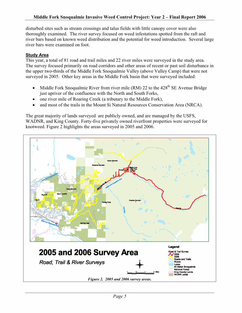
disturbed sites such as stream crossings and talus fields with little canopy cover were also thoroughly examined. The river survey focused on weed infestations spotted from the raft and river bars based on known weed distribution and the potential for weed introduction. Several large river bars were examined on foot. Study Area This year, a total of 81 road and trail miles and 22 river miles were surveyed in the study area. The survey focused primarily on road corridors and other areas of recent or past soil disturbance in the upper two-thirds of the Middle Fork Snoqualmie Valley (above Valley Camp) that were not surveyed in 2005. Other key areas in the Middle Fork basin that were surveyed included:
• Middle Fork Snoqualmie River from river mile (RM) 22 to the 428th SE Avenue Bridge just upriver of the confluence with the North and South Forks,
• one river mile of Roaring Creek (a tributary to the Middle Fork), • and most of the trails in the Mount Si Natural Resources Conservation Area (NRCA).
The great majority of lands surveyed are publicly owned, and are managed by the USFS, WADNR, and King County. Forty-five privately owned riverfront properties were surveyed for knotweed. Figure 2 highlights the areas surveyed in 2005 and 2006.
Figure 2. 2005 and 2006 survey areas.

Middle Fork Snoqualmie Invasive Weed Control Project: Year 2 – Final Report 2006
Page 6
Survey Results Nearly 40 acres of invasive weed infestations were identified in 2006. Himalayan and evergreen blackberry (Rubus discolor and Rubus laciniatus) found along road corridors continue to account for the largest percentage of the weed population. Likely introduced years ago, blackberries are persistent along active as well as closed roads. More than 11 acres of Bohemian knotweed were identified during the river survey. The knotweed infestations are centered between river miles 4.5 and the confluence and along Roaring Creek. However, isolated pockets were identified further up valley (outside of the river corridor). Other weeds of note include Scot’s broom (Cytisus scoparius) and English holly (Ilex aquifolium). Scot’s broom continues to be found sporadically throughout the valley. And, English holly was pervasive along the trails in the Mount Si NRCA and identified much further up valley. New additions not previously noted in the valley included relatively small infestations of the state-listed class B weeds yellow hawkweed (Hieracium caespitosum) and spotted knapweed (Centaurea biebersteinii) and pockets of English ivy (Hedera helix), a class C weed. A summary of the weeds identified, their state or county classification, and the total area identified in 2005 and 2006 are outlined in Table 1. Figure 3 identifies the locations of these weed populations. A list of priority areas of concern and additional maps can be found in the appendix.
Common Name Classification 2006 Total Net
Area (Acres) 2005 Total Net
Area (Acres)
Total Net Area 2005 + 2006 (Acres)
Himalayan & Evergreen Blackberry
Weeds of Concern 25.51 27.15 52.66
Bohemian Knotweed Class B 11.54 0.30 11.84 Scot's Broom Class B 3.87 2.52 6.39 Reed Canary Grass Class C 0.43 15.53 15.96 English Holly Weeds of Concern 0.42 Not Found 0.42 English Ivy Class C 0.27 0.00 0.27 Butterfly Bush Class C 0.20 1.13 1.33 Tansy Ragwort Class B 0.19 0.92 1.11 Yellow Hawkweed Class B 0.15 0.00 0.15 Canada Thistle Class C 0.04 1.01 1.05
Hedge Bindweed Weeds of Concern
0.03 0.40 0.43 Common Tansy Class C 0.01 0.40 0.41 Yellow Archangel Class C 0.01 Not Found 0.01 Yellow Flag Iris Class C 0.01 Not Found 0.01 European Mountain Ash Not Classified <.01 0.10 0.10 Spotted Knapweed Class B <.01 0.00 <.01 Totals 37.05 27.45 64.50
Table 1. Weeds identified and their coverage in the Middle Fork Snoqualmie Valley.

Middle Fork Snoqualmie Invasive Weed Control Project: Year 2 – Final Report 2006
Page 7
Figure 3. 2006 survey findings.

Middle Fork Snoqualmie Invasive Weed Control Project: Year 2 – Final Report 2006
Page 8
Figure 4. Volunteers removing blackberry.
Figure 5. KC staff pulling Scot’s broom.
Weed Control Projects Following up on survey findings, volunteers, conservation corps crews and agency and Greenway Trust staff completed extensive control projects throughout the Middle Fork of the Snoqualmie Valley. Highlights in 2006 include:
• A combined Greenway Trust/WADNR Washington Conservation Corps (WCC) & EarthCorps crew completed invasive control efforts along 14 miles of the main Middle Fork Road from the Dutch Miller Gap trailhead to its junction with the CCC Road. Over eight days, this included clearing Scot’s broom, Himalayan blackberry, reed canary grass, tansy ragwort, morning glory and many other weeds encroaching up valley. (The upper seven miles of the Middle Fork Road were identified as a priority as they will be decommissioned in 2007.)
• The King County Noxious Weed program, working with King County WCC and EarthCorps crews, controlled infestations of knotweed on the Middle Fork Snoqualmie and Roaring Creek. Over 18.5 days, the crews chemically injected over 11 acres of knotweed.
• The Greenway Trust completed 12 volunteer days, with 159 volunteers contributing 935 hours removing Himalayan and evergreen blackberry, Scot’s broom, tansy ragwort, English ivy, butterfly bush, etc. Projects took place on WADNR, USFS and King County lands.
• The Cascade Land Conservancy completed an additional four volunteer events, involving 36 volunteers who contributed 216 hours pulling blackberry and herb Robert on USFS and King County lands.
• King County Parks continued Scot’s broom removal at Tanner Landing and tansy ragwort control at the Three Forks Natural Area. Twenty-three volunteers contributed 100 hours at various events removing these weeds and King County staff completed another nearly 200 hours of weed control.
• The Greenway Trust restoration specialist injected three isolated knotweed patches up valley (two on WADNR lands on the Middle Fork Road and one on USFS land at the CCC/Middle Fork Road junction) and chemically treated butterfly bush at the CCC/Middle Fork Road junction.
Figure 6 highlights key weed control areas in the middle and upper sections of the Middle Fork Valley. Control efforts in the lower valley (including knotweed injection, tansy ragwort control, and Scot’s broom and English ivy control) are not shown on this map.

Middle Fork Snoqualmie Invasive Weed Control Project: Year 2 – Final Report 2006
Page 9
Figure 6. Control locations in middle/ upper Middle Fork Snoqualmie Valley (lower valley locations not shown).
Next Steps Three key steps are necessary to ensure the long-term success of this project. They include:
Continued Weed Control While significant progress has been made on weed control efforts, much work remains. In addition to controlling the weeds noted above, the few and relatively small infestations of butterfly bush, English ivy, yellow flag iris, yellow archangel, hedge bindweed, bittersweet nightshade, and poison hemlock make them priorities for control. These weeds are pervasive in urban parks and landscapes and their potential to become widespread and significantly alter native plant communities is well known. Strategies to control larger infestations of English holly, blackberry and Scot’s broom will be developed on a case by case basis (i.e. based on proximity to high value natural resources, risk of spreading, etc.). Volunteers, conservation corps crews and staff will continue to implement these control efforts in the coming years. (Volunteer projects are already scheduled for the first six months of 2007.) And, a mix of manual, mechanical and chemical means will continue to be incorporated into this weed control effort.

Middle Fork Snoqualmie Invasive Weed Control Project: Year 2 – Final Report 2006
Page 10
Completion of the Survey To date, approximately 80% of the existing Middle Fork Snoqualmie Valley road system, most of the river and a number of the trails have been surveyed. We must complete surveys in the most impacted areas of the valley (i.e. the remaining roads and sections of the river) to provide a more complete picture of the extent of weeds in the basin. Trails and off-trail areas will be surveyed on a case-by-case basis, depending on their proximity to known weed populations and the likelihood that infestations will spread into them. Monitoring Monitoring of the current weed control work will be an important component in the coming years. The identified high priority class B state-listed weeds (including yellow hawkweed, spotted knapweed and Bohemian knotweed) were largely treated and/or controlled in 2006. However, this represents only one year of control and seeds and root fragments are generally viable for several years. Revisiting these and other controlled sites annually to assess the success of the control and re-treating where necessary will be critical. Additionally, nearly every pull-out and spur road junction with the Middle Fork Road from the Bessemer Road to Valley Camp had one or more noxious weeds present that appeared to have been introduced directly from dumped yard waste. The most commonly introduced weeds found in old refuse piles were hedge bindweed, English ivy, and yellow archangel. These sites will require consistent monitoring.
The Greenway Trust, Cascade Land Conservancy, King County, Washington DNR and the US Forest Service will continue to seek support and funding to implement these next steps.

Middle Fork Snoqualmie Invasive Weed Control Project: Year 2 – Final Report 2006
Page 11
Appendix A Priority Areas of Concern

Middle Fork Snoqualmie Invasive Weed Control Project: Year 2 – Final Report 2006
Page 12
Priority Areas of Concern The following list highlights those areas identified during the survey that are of higher importance for control. They include areas infested with weeds that have a major impact on the riparian corridor (knotweed), state and county listed class B weeds (yellow hawkweed & spotted knapweed) and those weeds with generally limited distribution in the Middle Fork that are of concern (English ivy, yellow archangel, yellow flag iris, butterfly bush, poison hemlock). Sites are listed from up valley down.
• Middle Fork River bars and banks downstream of River Bend kayak put-in, including the Pratt River bar and the adjacent spur. The primary weed of concern is butterfly bush.
• Bessemer Road switchback near long spur at approximately four miles. The primary weed of concern is Bohemian knotweed.
• Pull-out on Middle Fork Road approximately one mile east of concrete bridge. The primary weed of concern is yellow archangel and yellow flag iris.
• Heavily impacted river front beach on WADNR property approximately 0.5 miles west of the concrete bridge. Primary weeds of concern were spotted knapweed and Scot’s broom.
• King County property known as the Gillis property. The primary weed of concern is yellow flag iris.
• All spur road junctions, pullouts, parking lots, and other sites of dumping activity along the Middle Fork Road from Valley Camp to the concrete bridge. Primary weeds of concern are bittersweet nightshade, hedge bindweed, English ivy, and yellow archangel.
• Spur road of Middle Fork Road (Forest Service Road 56) adjacent to Mailbox Peak trailhead. Primary weeds of concern are English ivy and yellow archangel.
• The Roaring Creek stream corridor and the Middle Fork Snoqualmie River course downstream of the confluence with Roaring Creek. The primary weed of concern is knotweed.
• The CCC Road junction with its longest spur road. The primary weed of concern is yellow hawkweed.
• Mt. Teneriffe Road switchback at approximately two miles. The primary weed of concern is butterfly bush.
• Boulder Garden Trail and the adjacent talus rocks. The primary weeds of concern are butterfly bush and Scot’s broom.
• Mt. Si trailhead and the first 0.5 miles of the trail. Primary weeds of concern are Bohemian knotweed and English ivy.
• Little Si trailhead and the first 0.2 miles of the trail. Primary weeds of concern are butterfly bush and poison hemlock
• The lower 4.5 miles of the Middle Fork Snoqualmie River. Survey efforts identified nearly 12 acres infested with knotweed in the riparian corridor.

Middle Fork Snoqualmie Invasive Weed Control Project: Year 2 – Final Report 2006
Page 13
Appendix B Weed Distribution Maps

Middle Fork Snoqualmie Invasive Weed Control Project: Year 2 – Final Report 2006
Page 14

Middle Fork Snoqualmie Invasive Weed Control Project: Year 2 – Final Report 2006
Page 15

Middle Fork Snoqualmie Invasive Weed Control Project: Year 2 – Final Report 2006
Page 16

Middle Fork Snoqualmie Invasive Weed Control Project: Year 2 – Final Report 2006
Page 17
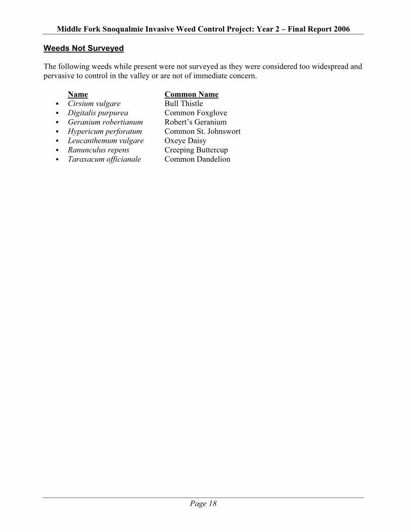
Appendix C Weeds Not Surveyed
Middle Fork Snoqualmie Invasive Weed Control Project: Year 2 – Final Report 2006
Page 18
Weeds Not Surveyed The following weeds while present were not surveyed as they were considered too widespread and pervasive to control in the valley or are not of immediate concern. Name Common Name
Cirsium vulgare Bull Thistle Digitalis purpurea Common Foxglove Geranium robertianum Robert’s Geranium Hypericum perforatum Common St. Johnswort Leucanthemum vulgare Oxeye Daisy Ranunculus repens Creeping Buttercup Taraxacum officianale Common Dandelion