inverleigh structure plan 2019 - goldenplains.vic.gov.au
TRANSCRIPT

INVERLEIGHSTRUCTURE PLAN2019

LIST OF FIGURES
Figure 1: Regional Context Plan
Figure 2: Inverleigh Planning Area, Population Data by Community Profile .id
Figure 3: Population growth from 2011 to 2017, Inverleigh Planning Area, Estimated Resident Population
Figure 4: Population Forecast Scenarios for Inverleigh
Figure 5: Age Structure, Service Age Groups, Inverleigh Planning Area and Victoria, 2016
Figure 6: Household Type, Inverleigh Planning Area, 2016
Figure 7: Number of Dwellings and Average Household Size, Inverleigh Planning Area, from .id Consultants
Figure 8: Potential Growth Areas
Figure 9: Inverleigh Feasibility Plan showing broiler farm
Figure 10: Inverleigh Heritage Precinct
ATTACHMENTS
Attachment A: Inverleigh Framework Plan, 2019
Attachment B: Inverleigh Structure Plan – Settlement Boundary
Attachment C: Inverleigh Structure Plan – Township Gateways and Approach
Attachment D: Inverleigh Structure Plan – Zoning and Land Use
Attachment E: Inverleigh Structure Plan – Neighbourhood and Character
Attachment F: Inverleigh Structure Plan – Heritage Plan
Attachment G: Inverleigh Structure Plan – Landscape and Open Space Plan
Attachment H: Inverleigh Structure Plan – Drainage Plan
Attachment I: Inverleigh Structure Plan – Infrastructure and Services Plan
Attachment J: Inverleigh Structure Plan – Movement and Access
Attachment K: Development Feasibility Study, 2018
Attachment L: Strategic Bushfire Risk Assessment, 2018
Attachment M: Current provisions of Clause 11.03-6L
2

3
INVERLEIGH STRUCTURE PLAN 2019 1 EXECUTIVE SUMMARY................................................................................................................................
1.1 INVERLEIGH SNAPSHOT ....................................................................................................................................
1.2 HowtheStructurePlaninfluencesthePlanningScheme.................................................................................
2. INVERLEIGH STRUCTURE PLAN 2019 .........................................................................................................
2.1 WhatisaStructurePlan?...................................................................................................................................
2.2 UseofaStructurePlan.......................................................................................................................................
2.3 HowhastheStructurePlanbeenprepared?......................................................................................................
2.4 TheInverleighStructurePlan2019....................................................................................................................
3. POLICY CONTEXT .......................................................................................................................................
3.1 TheStatePlanningPolicyFramework................................................................................................................
3.2 TheRegionalPlanningPolicyFramework–G21..................................................................................................
3.3 TheMunicipalStrategicStatement....................................................................................................................
3.4 TheInverleighStructurePlanReview2005........................................................................................................
3.5 TheLowDensityResidentialZoneLocalPlanningPolicy.....................................................................................
3.6 TheDomesticWastewaterManagementPlan2015..........................................................................................
3.7 InverleighFloodStudy2018...............................................................................................................................
3.8 StatePlanningPolicyClause13.02–Bushfire.....................................................................................................
3.9 GoldenPlainsRuralLandUseStrategy................................................................................................................
3.10 GheringhapIndustrialPrecinctandBannockburnBusinessPark........................................................................
3.11 GoldenPlainsRecreationStrategy......................................................................................................................
3.12 GoldenPlainsPathsandTrailsStrategy...............................................................................................................
3.13 InverleighCommunityPlan2013.......................................................................................................................
4. STAKEHOLDER ENGAGEMENT AND CONTRIBUTIONS .................................................................................
4.1 Community...........................................................................................................................................................
5. UNDERSTANDING THE PLACE ....................................................................................................................
5.1 Population–PastandPresent............................................................................................................................
5.2 Population-Future................................................................................................................................................
5.3 Infrastructure.............................................................................................................................................................
5.4 EnvironmentalRisks..........................................................................................................................................
5.5 Residential...............................................................................................................................................
5.6 NaturalEnvironmentandOpenSpace...............................................................................................................
5.7 CommunityFacilities.........................................................................................................................................
5
6
8
9
9
9
9
9
10
11
11
11
12
14
14
15
15
16
16
17
17
17
18
18
24
24
25
29
33
37
40
43
4
5.8 CulturalandBuiltHeritage...............................................................................................................................
5.9 CommercialandIndustrial...............................................................................................................................
5.10 Agriculture........................................................................................................................................................
5.11 DeveloperContributions..................................................................................................................................
6. THE VISION AND PRINCIPLES .................................................................................................................... 6.1 Vision................................................................................................................................................................6.2 Principles,Objectives&StrategiesforInverleigh...............................................................................................
7. IMPLEMENTATION ....................................................................................................................................7.1 CouncilActions.................................................................................................................................................7.2 DeveloperResponsibilities...............................................................................................................................
8. WAY FORWARD........................................................................................................................................
44
45
46
46
484849
585859
69

5
1. EXECUTIVE SUMMARYInverleighisrecognisedforitsvillagecharmandroleasameetingandstoppingplace,givenitsgatewaylocationbetweenGeelongandtheWesternDistrict.
Thehistorictownshipcoreislargelypreservedduetofloodingandlimitedlandcapability.
Inrecentyears,theareanorthoftheLeighRiverhasgrownasapopularalternativeforfamiliesseekingacountrylifestyleinawelcomingcommunity.Pressureforgrowthanddevelopmentwillcontinueandwithoutarevisedplan,decisionswouldberequiredtobemadeinisolation,withoutregardtothebigpictureorasetofprinciplesandobjectiveswhichreflectcurrentcommunitysentiment.
ThecommunitywantstoretainthevaluesandcharacterthatmakeInverleighpopular.Strategically,GoldenPlainsShirerecognisesInverleighasatownshipof‘districtcommercialandretailneedstoservicethesurroundingarea’.TheGoldenPlainsPlanningSchemedirectsthatresidentialdevelopmentbesupportedwithintheboundariesofexistingtownships.
Thisplanwillfacilitatemoderateresidentialgrowthofacontemporaryruralresidentialscale,withstrongdirectionthroughtheplanningschemetosustaintheessenceofInverleighasitcontinuestoprovideforandwelcomenewresidentsandbusinessestothetownship.ThisplanisconsistentwiththesustainablelevelofgrowththetownhasexperiencedsincetheInverleighStructurePlanof2005.

6
1.1 Inverleigh Snapshot
Inverleighisasmallsettlement,locatedapproximately30kmwestofGeelongand15kmsouth-westofBannockburn.Thetownischaracterisedbyheritagebuildings,strikingescarpmentsanditsriversetting.Thetowncentreisfocusedalongatraditionalmainstreet,whichaccommodatesavarietyofsmallcommercial,communityandeducationalfacilities.SituatedattheconfluenceoftheLeighandBarwonrivers,partsofthetowncentrearesubjecttofloodevents.
Lowdensityresidentialgrowthhasoccurredpredominantlytothenorthofthetowncentreonelevatedlandgenerallyunencumberedbythefloodingconstraintsexperiencedinandaroundthetowncentre.
Inverleighhasexperiencedgreaterthananticipatedgrowthinrecenttimes,attributableto:theGeelongRingRoadenablingbetteraccesstotheGeelongregionandMelbourne;thelowdensityresidentialhousingandthecountrytown‘village’appealderivedfromtheheritage;scaleandenvironmentalaspectsofthetown.
WhilethepopularityofInverleighhasgrown,withyoungfamiliesattractedtothelowdensityresidentiallifestyle,residentialgrowthisconstrainedbythelackofsewerageandsusceptibilitytofloodinginmanyareas.
Figure 1: Regional Context Plan
1.1.1 Regional roleInverleighisasatellitetownshipoftheregionalcentreofGeelong.ManyresidentscommutetoGeelongorbeyondforworkandhighereducation.Inverleighprovidesalowscaleretail,serviceandcommunityroletoitsresidentsandsurroundingruralcommunity,andoffersasmalltownlifestylealternativetothenearbytownsofBannockburnandGeelongwhichsupportthetownbyprovidinghigherorderretailandcommunityservices.
Shelford - Bannockburn Rd
Rokewood - Shelford Rd
Inverleigh - Shelford Rd
Inve
rleig
h - W
inch
else
a
Rd
Steiglitz Rd
Geelong - Ballan Rd
Geelong - Bacchus M
arsh Rd
Corio -
Wau
rn P
onds R d
To Ballarat
ToMelbourne
To WesternRegion
To WesternRegion
ToQueenscliff
ToTorquay
Hamilton Hwy
Hamilton Hwy
Midland Hw
y
Midland Hwy
Princes Hwy
Bellarine Hwy
Prince
s Fw
y
Princes Fwy
Surfc
oast
Hw
y
Shelford
Lethbridge
Bannockburn
Teesdale
Batesford
Lara
Geelong
Leopold
Moriac
Waurn Ponds
Winchelsea
Inverleigh
Avalon
26 July 2018
Regional Context Plan1:65000
0 1000 2000 3000 4000 m
1:130000at A1 at A3Level 2, 6 Riverside Quay Southbank, VIC 3006
t 9695 3025 e [email protected]
INVERLEIGH STRUCTURE PLANGolden Plains Shire Council
7
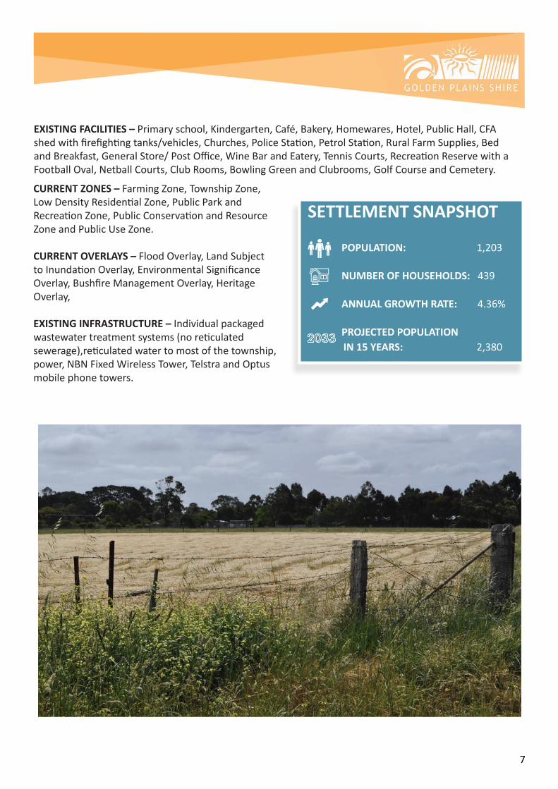
EXISTING FACILITIES –Primaryschool,Kindergarten,Café,Bakery,Homewares,Hotel,PublicHall,CFAshedwithfirefightingtanks/vehicles,Churches,PoliceStation,PetrolStation,RuralFarmSupplies,BedandBreakfast,GeneralStore/PostOffice,WineBarandEatery,TennisCourts,RecreationReservewithaFootballOval,NetballCourts,ClubRooms,BowlingGreenandClubrooms,GolfCourseandCemetery.
CURRENT ZONES – FarmingZone,TownshipZone,LowDensityResidentialZone,PublicParkandRecreationZone,PublicConservationandResourceZoneandPublicUseZone.
CURRENT OVERLAYS – FloodOverlay,LandSubjecttoInundationOverlay,EnvironmentalSignificanceOverlay,BushfireManagementOverlay,HeritageOverlay,
EXISTING INFRASTRUCTURE – Individualpackagedwastewatertreatmentsystems(noreticulatedsewerage),reticulatedwatertomostofthetownship,power,NBNFixedWirelessTower,TelstraandOptusmobilephonetowers.
SETTLEMENT SNAPSHOT POPULATION: 1,203
NUMBER OF HOUSEHOLDS: 439
ANNUAL GROWTH RATE: 4.36%
PROJECTED POPULATION IN 15 YEARS: 2,380
8
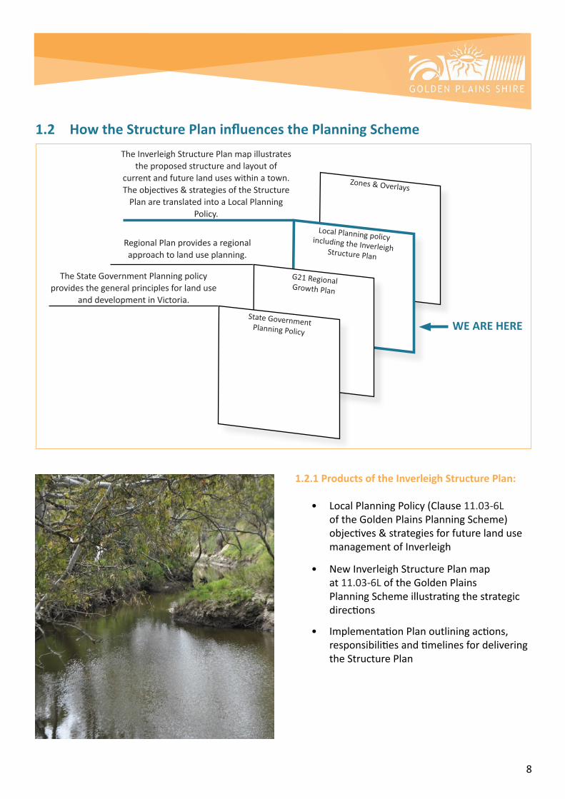
1.2.1 Products of the Inverleigh Structure Plan:
• LocalPlanningPolicy(Clause11.03-6L oftheGoldenPlainsPlanningScheme) objectives&strategiesforfuturelanduse managementofInverleigh
• NewInverleighStructurePlanmap at 11.03-6LoftheGoldenPlains PlanningSchemeillustratingthestrategic directions • ImplementationPlanoutliningactions, responsibilitiesandtimelinesfordelivering the Structure Plan
TheInverleighStructurePlanmapillustratestheproposedstructureandlayoutof
currentandfuturelanduseswithinatown.Theobjectives&strategiesoftheStructurePlanaretranslatedintoaLocalPlanning
Policy.
RegionalPlanprovidesaregionalapproachtolanduseplanning.
TheStateGovernmentPlanningpolicyprovidesthegeneralprinciplesforlanduse
anddevelopmentinVictoria.
1.2 How the Structure Plan influences the Planning Scheme
WE ARE HERE

9
2. INVERLEIGH STRUCTURE PLAN 2019
2.1 What is a Structure Plan?
AStructurePlanexpressesthedesiredoutlookforthefutureofatown,includingitsspatialarrangement,thevarietyofuses,thescaleandformofdevelopmentaswellastheinfrastructurerequiredtosupportwhatisenvisaged.
2.2 Use of a Structure Plan
ThisStructurePlanwillreplacethecurrentInverleighStructurePlan2005withintheGoldenPlainsPlanningSchemeandwillguidedecisionsonproposalstorezone,developandpursuelandusechangesinthetownship.
2.3 How has the Structure Plan been prepared?
Theplanconsidered:
• Relevantexistingplans,policiesandstrategies;
• Inputandfindingsfromcommunityandstakeholders;
• Analysisofnewpopulationstatistics,findingsoftheDomesticWastewaterManagementPlan2015andlatestfloodmappingandfindingsfromtheInverleighFloodStudy2018;
• Changesinlanduse,settlementpatterns,communityandtourismactivities,events,recreationandcommercialprecincts;
• Movementoffreight,vehicles,pedestrians,cyclistsandhorseriders;
• Thenatural,culturalandheritagefeaturesofthetown;and
• Arangeofprinciplesanddirectionstobalancepressuresforgrowthwhilstretainingtheintrinsicqualitiesofthetown.
2.4 The Inverleigh Structure Plan 2019
TheInverleighStructurePlan2019hasbeeninformedbytheInverleighStructurePlanof2005. Purposefully,thetownshipgrowthboundaryisretained,asaremanyfeaturesincludingthegreenlinksandinterfacetreatmentsbetweenresidentiallanduseandtheInverleighFloraReserve,theGolfCourseandfarmingareas.

10
NewdirectionsoftheStructurePlan2018derivefrom:
• Communityfeedback;• ChangestoStateZoningprovisions;• ChangestoLocalPlanningpolicy;• Populationgrowth;• TheDomesticWastewaterManagementPlan2015;and• TheInverleighFloodStudy2018.
Inverleighhasexperiencedafasterrateofgrowththanwhatwasanticipatedandforecastinthe2005InverleighStructurePlan.Thisgrowthiscoupledwithincreasingpressurefromdevelopersforrezoning,particularlyinthenorthofthetown,aswellassomeinterestinthesouthwestofthetown,earmarkedforfutureresidential.
Councilneedstobewellinformedandreadytorespondtothegrowthpressuresandproposalstorezone,developandpursuelandusechanges.Thenewstructureplanbuildsontheoutcomesofthe2005StructurePlanandprovidesdirectionstoguidelandusedecisionsinInverleighforthenext10-15years.
ThevisionforInverleighhasbeenrevisedtorepresentthesenseofplaceandaspirationsofthecommunity,whilstretainingthecorevaluesthatrundeepthroughthetown’shistory.
Asetofprinciplestodistinguishthesevaluesandinterpretthevisionhavebeendeveloped.ThesewillinformlandusedecisionsforInverleighintothefuture.
3. POLICY CONTEXT TheroleandfunctionofInverleighisguidedbyapolicycontextthatincludesthefollowing:
• G21RegionalGrowthPlan(GeelongRegionalAlliance,2013)• MunicipalStrategicStatement• RuralLanduseStrategy• Clause13.02Bushfire• DomesticWastewaterManagementPlan

11
3.1 The State Planning Policy Framework
StatePlanningPolicystatesthatplanningistoanticipateandrespondtotheneedsofexistingandfuturecommunitiesthroughprovisionofzonedandservicedlandforhousing,employment,recreationandopenspace,commercialandcommunityfacilitiesandinfrastructure.
Planningistofacilitatesustainabledevelopmentthattakesfulladvantageofexistingsettlementpatternsandinvestmentintransport,utility,social,communityandcommercialinfrastructureandservices.Stateplanningsupportsanetworkofsettlementstoprovideforgrowthinpopulationwithinamunicipalandregionalcontext.
3.2 The Regional Planning Policy Framework – G21
InverleighisidentifiedinTheGeelongRegionPlanasa‘Town’ofbetween500-2000persons.Theplanacknowledgesthatsomesmalltownshavethepotentialforgrowththatwouldnotcreateademandforextraservicesorinfrastructureanddescribesthisasanefficientuseofresources.
Further,theplanstatesthattheeconomichealthoftheregionisaboutmaintainingviabletownshipsaswellasdealingwithgrowth.Inthisregard,smallerruraltownshipsshouldallowforlimitedlowdensityresidentialdevelopment.
3.3 The Municipal Strategic Statement
Inverleighisidentifiedasa‘Districtcommercialandretailcentre’withintheGoldenPlainsShireCommercialandRetailHierarchyFrameworkatTable1ofClause02.03-7oftheGoldenPlainsPlanningScheme.
SettlementpolicyforGoldenPlainsShireisarticulatedatClause11.01-1LoftheSchemewhereitstates:
There is pressure for subdivision and development outside existing townships, particularly for subdivision and hobby farm development close to Geelong and Ballarat. Residential developmet is not supported outside existing township boundaries.
Futureuseanddevelopmentofurbancentresandsmalltownswilllargelycentreonthetraditionalcharacterandformofthesetowns.Themaintenanceofacleardistinctionbetweenurbanandruralareasisessentialtocontinuedagricultureandefficienttownshipdevelopmentandmaximisingtheuseofinfrastructure.
PolicydirectionforInverleighisprovidedatClause11.03-6LoftheGoldenPlainsPlanningScheme.TheobjectivesandstrategiesoutlinedinthispolicyarebasedonthefindingsoftheInverleighStructurePlan2005.

12
3.4 The Inverleigh Structure Plan Review 2005
TheInverleighStructurePlan2005(ISP2005)wasincludedintheGoldenPlainsPlanningSchemethroughAmendmentC37.Whilstthegrowthratehasbeenfasterthananticipated,theISP2005hasensuredorderlyandrespectfulresidentialandcommercialdevelopmentwhilstprotectingandenhancingtheenvironmentalandheritageassetsofthetown.
Key outcomes include:
• ApplicationoftheHeritageoverlaytotheInverleightowncentre;• RezoningandresidentialgrowthinaccordancewiththeISP2005;• ProvidingfirebreaksbetweentheGolfCourseandresidentialdevelopment;• Newandupgradedrecreationalandcommunityfacilities;• Newbusinessandcommercialenterprises;• Provisionofcaravan,trailer,busandtruckparkinginthemainstreet;and• ContinuationoftrailsalongtheLeighRiver.

13
Outstanding outcomes:
South West Area – Low Density Residential Area
ThesouthwestareaofInverleighearmarkedforLowDensityResidentialZoneandFutureLowDensityResidentialZoneremainsintheFarmingZoneandhasnotyetbeenrezoned.CouncilhasundertakenaFeasibilityStudyintotheareatoanalysethedevelopmentconstraintsandprovideguidancefordecisionmakerswhenconsideringfuturerezoningandsubsequentsubdivisiondevelopmentproposalsinthisarea.Findingsincludethepreparationofaplanillustratingtheopportunitiesandconstraintsofthesiteandasetofprinciplestoclarifytheintentionsandexpectationsforthesite.TheDevelopmentFeasibilityStudyPackageisnowaresourceavailableforlandownersinthisareaandisprovidedatAttachmentK.Futuredevelopmentofthisareawillbeowner/developerled.
Rural Activity/ Rural Industry Area
DevelopmentoftheRuralActivity/Industryareashasnotprogressedatthisstage.Thisisagainamarketdriveninitiativerequiringprivatesectorinvestment.TheprovisionsoftheFarmingZonenowenableamorediversearrayofactivitiestobeconductedwithinthezoneandapplicationscanbemadeunderthecurrentFarmingzoningforsuchuses.
Regionally,GoldenPlainsShirehasidentifiedandpreparedtheGheringhapStructurePlanasastrategicemploymentarea.Notwithstandingthis,thereremainspotentialfortheareaonthecorneroftheHamiltonHighwayandMahersRoad,westofInverleightobeusedanddevelopedforRuralbasedIndustry.ThegatewaypositionontheHamiltonHighwayandtheproximitytoarailwaysidingarefactorswhichmakethisareastrategicallysuitedtoruralindustryservicingthelocalandwiderfamingregion. Light Industrial Development
LightindustrialdevelopmentanduseofthelandbetweentheRecreationReserveandtheSchoolWoodlotonRailwayStreet,hasnotoccurred,astherehavebeennofirmproposals.Thesiteiscurrentlyusedforthelaydownofmaterialsassociatedwithmaintainingfreightinfrastructure.Inthefuturethesiteremainssuitableforlightindustrytoservicetherailinfrastructureorcommunitywithoptionsforlandscapesupplies,tradeservices,storageorparking.
Extension of the Township Zone
TheextensionoftheTownshipZonesouthofVictoriaParkhasnotoccurredasthedevelopmentofthisareawouldrequiretheinstallationofaseweragesystemwhichremainsunfeasibleatthistime.

14
3.5 The Low Density Residential Zone Local Planning Policy
SignificantchangestoCouncil’sLowDensityResidentialZonepolicywereintroducedtotheGoldenPlainsPlanningSchemeinNovember2013byAmendmentC64.
ThenewpolicyprovidesguidancetoapplicantsonwhatCouncilconsidersimportantwhenconsideringsubdivisioninthelowdensityresidentialzone.Ratherthanstipulatingaminimumlotsizeof1.0ha,Councilnowconsiderslotssmallerthan1.0haif:
• Alandcapabilityassessmentdemonstratesthatthesoilcharacteristicscansupportresidential developmentandthesubsequenteffluentdisposaloutputs;
• Thesubdivisionisdemonstratedtorespondandfitcomfortablywithintheestablishedcharacterof thearea(applicableindevelopedlowdensityresidentialareas,ratherthangreenfieldsites).
Thepolicyreflectscommunityattitudesofresidentsconcernedthatthevaluedcharacteroftheirestablishedlowdensityresidentialareawouldbedamagedbysmalllotsubdivisions.
ThenewlocalplanningpolicyalignswiththeminimumlotsizeprovidedintheStatePlanningPolicyzoneprovisionsandarticulatesthelocalenvironmentalandcharacterfactorsforconsiderationandimportancetoCouncilandthecommunity.
3.6 The Domestic Wastewater Management Plan 2015
TheDomesticWastewaterManagementPlan(DWMP),July2015wasdevelopedtoprovideanunderstandingofthebestapproachtomanageeffluentdisposalthroughoutGoldenPlainsShire.Thedocumenthasaparticularfocusonthesmallun-seweredtownsincludingInverleighthatareexperiencingincreasedpressureforadditionalresidentialdevelopment.
Essentially,theDWMP2015foundthatforGreenfielddevelopment(changingfarmingtoresidential),theminimumlotsizeforsubdivisioninun-seweredareascouldbeaslowas4,000sqm.Likewise,forinfilldevelopment,occurringonexistingsmalllotsandlotscreatedthroughre-subdivisionatleast4,000sqmisrequired.
ThisisconsistentwiththeminimumlotsizestipulatedintheStatePlanningprovisionsforresidentiallandinun-seweredareas,wheretheLowDensityResidentialZoneapplies.
TheISP2005anticipatedthatseweragemaybedeveloped,howeverfurtherinvestigationhasindicatedthatsewerageisnotfeasibleintheforeseeablefuture.
ThesituationregardingsewerageatInverleighhaschangedverylittlesince2005,exceptthatthereisnowperhapsmorepressureforahigherdensityofdevelopmentandlessappetitefromwaterauthoritiesandstategovernmenttofundreticulatedsewerage.TheDWMPsuggests“thatthefeasibilityofsewerageforInverleighshouldberevisited,withafocusonalternativenon-traditionalmeansofcollecting,naturaltreatmentanddisposalorreuse.Howeverthereisaneedtofirstbuildsufficientevidencetodemonstratethatthisisthebestoptionforthetown.

15
Itisalsorecommendedthatstormwaterqualitymonitoringisundertakenandanengagement/educationprogramisestablishedforresidentstopromotebestpracticeonsitewastewatermanagement.”
Itisrelevanttothisplan,thattheconstraintsoffloodingandlackofsewerageinthetowncombinetolimitdevelopmentofthecoretownshipandthesefactorshavesignificantlycontributedtothetownshipretainingthevillagescaleofdevelopmentandcharacter.Inverleighissomewhatprotectedfromurbanisationbythelackofsewerageandfloodconstraints.Withoutstatefundingandawillingnessbywaterauthoritiesandthecommunity,asewerageschemeisunlikelytobepursued,unlesswaterqualityandassociatedhealthimplicationsarise.Continuedwaterqualitymonitoringisrequiredtoaudittheimpactsofwastewatermanagementinthetownship.
TheISP2005identifieslandnorthofHopesPlainsRoadforthepossiblelocationofaSewerageTreatmentPlant.WhilstnotincludedonthenewStructurePlan,thesuggestedlocationremainsrelevantforfutureplanning.
3.7 Inverleigh Flood Study 2018
CouncilcommencedpreparationoftheInverleighFloodStudyinDecember2016.Thiswastimelyasitensuredthemostup-to-datefloodmappingcouldbeusedtoinformtheInverleighStructurePlan,whichhasbeenpreparedconcurrently.ThestudywaspreparedinconsultationwiththeDepartmentofEnvironment,Land,Water&Planning,theCorangamiteCatchmentManagementAuthority(CCMA,WaterTechnologyconsultantsandtheInverleighcommunity.
TheStudyprovidesadetailedassessmentoftheInverleightownshipfloodplainandidentifieswherefloodingmayimpactuponresidents,propertiesandinfrastructure.Thestudyprovideshighqualityup-to-datefloodmappingthatpredictsfloodingheightsandidentifieshighriskareasforfloodwarningandevacuation.Thestudyrecommendsfurtherdetailedassessmentoftwomitigationoptionswhichwouldreducefloodingthroughthetownship.TheMunicipalFloodEmergencyPlan(MFEPwillalsobeupdatedwithfloodintelligencefromthisstudy.
ThefloodmappingproducedbytheInverleighFloodStudy2018hasbeenincorporatedintotheInverleighStructurePlan2019.
3.8 State Planning Policy Clause 13.02 – Bushfire
AStrategicBushfireRiskAssessmentforInverleighhasbeenpreparedbyGoldenPlainsShireinresponsetotheStatePlanningPolicyatClause13.02relatingtoBushfire.
TheRiskAssessmentconsideredsix(6areasforpotentialresidentialgrowthasprovidedinthedraftInverleighStructurePlandated2018.Followingassessmentofthebushfireriskateachofthesesites,thereportconcludedthattheproposalsforresidentialgrowthinInverleighareappropriatefromabushfireriskperspective,providedthemeasuresidentifiedintheAssessmentaretakentominimisetherisktoresidentsandemergencyservices.

16
3.9 Golden Plains Rural Land Use Strategy
InJanuary2008,CounciladoptedtheGoldenPlainsRuralLandUseStrategy,toguidefuturelanduseanddevelopmentacrosstheShire’sruralareas.ThestrategyrespondedtotheintroductionofanewsuiteofRuralZonesbytheVictorianStateGovernment.
ObjectivesoftheRuralStrategythatarerelevanttotheInverleighStructurePlaninclude:
• Supportandpromoteproductiveandsustainableagricultureandruralenterprises;
• Provideforplannedruralresidentialandrurallivingdevelopmentwhereitsupportstheexisting settlementstructure,doesnotimpactonproductiveagriculturallandusesandprovidesfor enhancedenvironmentaloutcomes;
• Strengthentheeconomic,socialandcommunitywellbeingoftheShire’stownsandsettlements;
• Provideforvalueaddingruralindustries,includingintensiveanimalindustries,wheretheycan besitedsoastoavoidconflictsandimpactsontownsandsettlements,residentialuses,other agriculturalusesandidentifiedenvironmentalvalues;
• Workwithlandowners,communitygroupsandrelevantagenciestoimprovethenaturalresource base,thewaterqualityandquantityinriversandstreamsandtheprotectionoftheShire’s environmentalassets;
• Strengthentheruraltourismeconomybyencouragingusesanddevelopmentsthatsupportthe Shire’stouristproductwithoutcompromisingthelandscapeandenvironmentalvalues;
• MaintainthequalityoftheShire’srurallandscapesandthenon-urbanbreaksbetweentownsand settlements.
3.10 Gheringhap Industrial Precinct and Bannockburn Business Park
TheGheringhapStructurePlan2013waspreparedwithinputfromthecommunityandcatersforeconomicgrowth.DevelopmentofthestructureplanhasrespondedtothecharacteristicsandtheuniquenaturalenvironmentofGheringhap.Inparticular,thestructureplanseekstoretaintheruralatmosphere,whilstallowingforappropriateeconomicgrowth.TheGheringhapStructurePlan’semploymentareaencouragesincreasedinvestmentandprovisionofnewemploymentopportunitiesintheareathatwillmakeapositivecontributiontothelong-termeconomicviabilityofGheringhapandtheregion.
TheStructurePlanpresentsavisionandplanningframeworkfortheintegrateddevelopmentofanemploymentareawhichwillencourageinvestmentinGheringhap.TheplanhasrelevancetotheInverleighStructurePlanasitencouragesindustrytolocateinthisGheringhapregion.TheBannockburnBusinessParkprovidesaregionaloptionforhigherorderserviceandindustrytolocateinthelocality.

17
3.11 Golden Plains Recreation Strategy
TheRecreationStrategy2015-2019outlinesGoldenPlainsShire’skeydirectionsandprioritiesforrecreationprovisionintheShireandtheactionitwilltakeduringtheperiod2015to2019toimplementthesedirectionsandpriorities.
InregardstorecreationprojectsinInverleigh,significantworkshavebeenundertakentoupgradefacilitiesattheInverleighRecreationReserveandfundingwillcontinuetobesoughtforfuturework.LongtermplanningwouldseethetenniscourtsrelocatedtotheRecreationReserve,howeverthecostintheshorttermisprohibitive.
OtherinitiativesidentifiedintheRecreationPlanincludeawalkingtrailfromtheInverleighGolfCoursetoTeesdale(alreadyusedbyhorses)andcontinuedmaintenanceanddevelopmentofthewalkingtracksalongthe river.
3.12 Golden Plains Paths and Trails Strategy
ThegoalofthePathsandTrailsStrategyistoprovidestrategicdirectionwhenassessingwhethertorepair,upgrade,orconstructapathortrailwithintheShireoverafive(5)yearperiod.Areportwasproducedtoprioritisepathdevelopmentbasedonarangeofobjectivesseekingaconnectedcommunityandequitabledistributionofpathsandtrailsacrossthemunicipality.WithintheboundsofwhatCouncilandthecommunityhavecapacitytodeliver,maintainandmanage.
3.13 Inverleigh Community Plan 2013
Theprioritiesidentifiedincommunityplansareimportantastheyareakeyreferencepointinstrategicplansandareusedtodetermineprioritiesforexternalfundingandtheneedforspecificprojectsandprograms.TheoverallvisionoutlinedisthatInverleighmustmaintainitscountryidentityandnotoverdevelop.
TheprioritiesidentifiedintheInverleighCommunityPlanhavebeendevelopedbyitscommunityandincludedevelopingandenhancingtheriverenvironsandwalkingtrackandcelebratinghistoricandnaturalassets.

18
4. STAKEHOLDER ENGAGEMENT AND CONTRIBUTIONS
4.1 Community
CouncilcommencedcommunityengagementinMarch2017withacommunitysurvey.TwoworkshopsfollowedandtwolisteningpostsessionswheretheStrategicPlanningTeammetwithresidentstodiscussfuturelanduseplanningforInverleigh.
Morethan120surveyresponseswerereceivedwhichrepresentsaround10%oftheInverleighcommunity.Keyfindingsfromthesurveyfoundapositivesenseofcommunity,countrylifestyle,proximitytolargetownsandtheruralambianceasbeinghighlyvalued.Areasforimprovementincludedroads,rateofdevelopmentandgrowthaswellastheprovisionofservicesincludingpublictransport.Thesurveyidentifiedthereisnosingularpreferredoptionwithinthecommunityforfuturegrowth.
Thesurveyaskedthefollowingfivequestions,responsestothecommunitysurveyaresummarisedbelow.
The survey asked the following 5 questions:
What do you like about living in Inverleigh?
What do you dislike about living in Inverleigh?
Where do you work?
How long have you lived in Inverleigh?
Preferred option for future growth?
123Responses

19
Questions 1 and 2: What do you like/dislike about living in Inverleigh?
SenseofCommunity
CountryLifestyle
Nothing
Roads
Smalltowninproximitytolargertowns
Increasedevelopment
LackofServices
LackofPublicTransport
LimitedCommercial
Rates
RuralAmbiance
Environment
LargerLots
Facilities
Liveability
Likes Dislikes
54
44
32
30
23
17
14
12
27
27
15
15
10
8
6

20
Question 3: Where do you work?
Question 4: How long have you lived in Inverleigh?
0-10years 11+years
40%
60%
63%Geelong
17% Other
9%Melbourne
8%Bannockburn
3%SurfCoast
Inverleigh
Bannockburn
Teesdale toMelbourne
Murgheboluc
Geelong

21
Question 5: Preferred option for future growth
Presenting the balance of community response to question on growth:no growth v growth
Nodevelopment(37%)GreenfieldDevelopment(20%)
InfillDevelopment(16%)CombinationofInfillandGreenfieldDevelopment(27%)
27%
20%
37%
16%

22
Councilheldacommunityworkshopon26October2017toprovideresultsofthecommunitysurvey,stakeholderengagementandthelatest2016censusfindings(whichwerereleasedbetweenJuneandOctober2017).Therewasastrongturnoutwithrobustandhealthydiscussionamongstthecommunityonkeystructureplanningissues.Theworkshopfindingsdemonstratedthatwhilethereisamixofviewsonparticularissues,thereisalsowidespreadsupportforthefollowing:
• Retainingthevillagecharacter,withitshistoricandnaturalenvironmentswhicharecornerstonesof thetown’scharmandappeal;• OngoingdependencyonhigherorderserviceswithinBannockburnandGeelongsoastopreserve Inverleigh’svillagescaleandcharacter;and
• Supportforthecontinuationofboutiquescalecommercialdevelopmentandre-useofexisting buildingsinthemainstreet.
Brainstormingaroundthefollowingkeystructureplanningissueswasundertaken,whichcontributedtothevision,principlesanddirectionsoftheStructurePlan:
• Vision;• LandUse(residential,commercial,openspace,industryandcommunity);• Physicalattributes;and• Movement–connections-accessibility.
Examplesoftheworkshopbrainstormingactivitiesareshownbelow.

23
CouncilheldtwolisteningpostsinInverleighon16and23June2018topresentthedraftInverleighStructurePlan.Thisprovidedanopportunityforone-on-onediscussionsbetweenCouncilplannersandaround70peoplefromthecommunity.Detailedandvaluablefeedbackwasreceivedincludingsevenwrittensubmissions.
Insummary,CouncilcontinuedtohearclearmessagesaboutInverleigh,includinghowthecountrytown/villagecharacterischerishedbythecommunityandissomethingtoberetained.Onthematteroflotsizes,therewereconflictingviews.Someresidentswanttosubdividebecausetheydon’twanttomanagelargelotsizes,otherswanttoretainthe1haminimumlotsize.Proposalsforruralandserviceindustry,commercial,recreationandsuggestionsforhorse/bridlepathswerealsoprovidedbythecommunityatthelisteningpostsandinthewrittensubmissions.
24
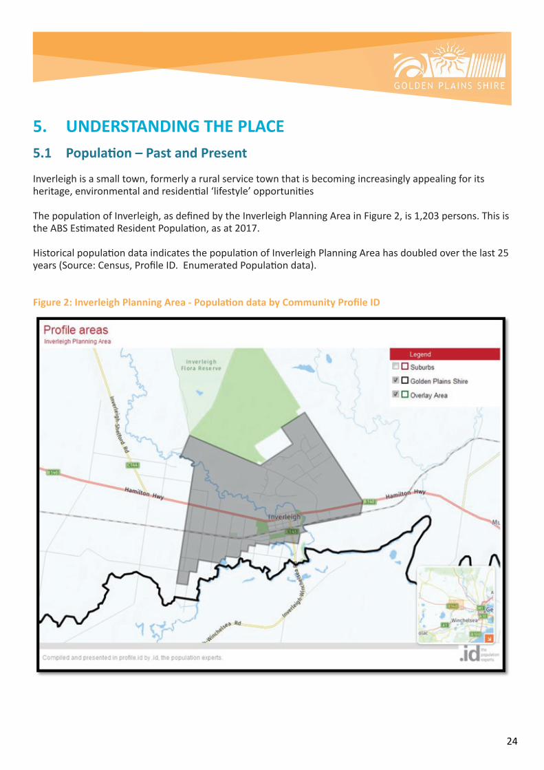
5. UNDERSTANDING THE PLACE5.1 Population – Past and Present
Inverleighisasmalltown,formerlyaruralservicetownthatisbecomingincreasinglyappealingforitsheritage,environmentalandresidential‘lifestyle’opportunities
ThepopulationofInverleigh,asdefinedbytheInverleighPlanningAreainFigure2,is1,203persons.ThisistheABSEstimatedResidentPopulation,asat2017.
HistoricalpopulationdataindicatesthepopulationofInverleighPlanningAreahasdoubledoverthelast25years(Source:Census,ProfileID.EnumeratedPopulationdata).
Figure 2: Inverleigh Planning Area - Population data by Community Profile ID

25
Thetown’scloseproximitytoGeelong,andtheGeelongRingRoad,alongwiththeappealoflowdensityresidential‘lifestyle’opportunities,arelikelytobethekeydriversoffuturegrowthinInverleigh.CensusdatatellsusthatmigrationtotownsinthesoutheastoftheShirecomesfromGreaterGeelongandWyndham.
TheimplicationsoftheGeelongRingRoadandthetown’sgrowingpopularityhasbeenevidentwiththepopulationofInverleighgrowingby225people(23.8%)from2011to2016.Thisrepresentsanaverageannualpopulationchangeof4.36%overtheperiod.(Profile.idUsualResidentPopulation,AustralianBureauofStatistics,Census2011and2016).
FurtherinsightintotheInverleighPlanningArea’spatternofpopulationgrowthisprovidedbytheEstimatedResidentialPopulation2011-2017asitisanannualmeasure–seeFigure3.Between2011and2012therewasahighgrowthrateof7.63%,facilitatedbyavailabilityofadditionalresidentiallots.Sincethen,between2012and2017,averageannualpopulationgrowthhasreducedtoamoreconservativegrowthrateof2.88%perannum,reflectingthelimitedsupplyofresidentiallotsavailableduringthattimeperiod.
Figure 3: Population Growth from 2011 to 2017, Inverleigh Planning Area, Estimated Resident Population
5.2 Population - FutureWiththepopulationofInverleighcalculatedat1,203personsin2017,anumberofscenarioscanbeusedtoforecastpopulationchangeto2033,basedonvariousrecordedpopulationgrowthratesinInverleighreferredtoabove.SeeFigure4.
Conservative:Aconservativeestimatedgrowthrateof2.88%perannum,wouldseethepopulationgrowto 1,895 by 2033(basedontheEstimatedResidentPopulationgrowthrate2012-17).
Moderate: Amoderateestimatedgrowthrateof4.36%perannum,wouldseethepopulationgrowto2,380 persons by 2033(basedontheUsualResidentPopulation’saverageannualgrowthrate2011-2016).
Source:AustralianBureauofStatistics,RegionalPopulationGrowth,Australia(3218.0).Compiledandpresentedinprofile.idby.id,thepopulationexperts)
EstimatedResidentPopulation,InverleighPlanningArea,2011-2017
1300
1200
1100
1000
900
800
9701,044
1,0801,114 1,145
1,180 1,203
2011 201220132014201520162017

26
High: Ahighgrowthscenario,wouldseethepopulationgrowto 3,900 by 2033(basedonthehighestannualEstimatedResidentPopulationgrowthraterecordedinthe2011-17period-7.63%in2011-12).
Populationforecastingconsultants,.idConsultingrecommendusingtheUsualResidentPopulationgrowthrate.Thisrepresentsthemoderatescenarioof4.36%growthperyear.Thisscenarioforecasts2,380personsby2033,whichnearlydoublesthecurrentpopulationofInverleigh.Itrepresentsanincreaseof 1,177 persons and 431 houses, based on an average household size of 2.73 persons(2016Profile.id).ThenewStructurePlanaimstoprovideforthisscenario’scontinuedgradualgrowthofthetown.
Figure 4: Population Forecast Scenarios for Inverleigh
Aprojectedpopulationof2,380personsin15years’timeequatestoanadditional1,177personsand431houses,basedonanaveragehouseholdsizeof2.73persons.
5.2.1 Age Structure
ThemedianageofthepopulationintheInverleighPlanningAreais39years.TheInverleighPlanningArea,hasayoungerageprofilethanRegionalVictoria,withyoungfamiliesevident.In2016,26.6%ofthepopulationwasagedbetween0and17(RegionalVictoria21.9%)and16.4%wereaged60yearsandover(RegionalVictoria27.3%).Withinthis,‘babiesandpre-schoolers’were7.8%ofthepopulation(comparedwithRegionalVictoria5.8%)and‘Primaryschoolers’10.9%(RegionalVictoria8.7%).Thelargestserviceagegroupwas‘ParentsandHomebuilders’(aged35-49years)with286personsrepresentingnearlyaquarterofthetown’spopulation.SeeFigure5.
Scenario Average Annual
growth rate 2017-33
2017 2033 Change Av. persons per year
Dwellings av. hh size 2.73 (rounded)
Growth rates based on recorded Inverleigh Rates
Conservative 2.88 1,203 1,895 692 43 255 EstimatedResidentPopulationgrowthrate2012-17
Moderate 4.36 1,203 2,380 1,177 74 431 UsualResidentPopulation2011-16
High 7.63 1,203 3,900 2,697 169 990 EstimatedResidentPopulation2011-12
Inverleigh Planning Area - Population forecast scenarios
Projected: 2,380 persons by the Year 2033

27
Figure 5: Age Structure – Service Age Groups, Inverleigh Planning Area and Victoria, 2016
Lookingatthefiveyearsprior,thebiggestchangehasbeeninthenumberof‘ParentsandHomebuilders’(35-49years)(59additional)and‘BabiesandPre-schoolers’aged0-4years(42additional).Anothergrowinggroupisthe‘OlderworkersandPre-retirees’(50-59)with42additionalpersons.
Overthelongertermbetween2006and2016,therehavebeenincreasingnumbersinallserviceagegroupsexcept‘SecondarySchoolers’aged12to17andtheelderlyaged85andover.Thenumberof‘SecondarySchoolers’hasremainedsteadyaround90personswhilethenumberof85yearsandoverhasbeenlessthan10since2006.
5.2.2 Households
Householdtypeisoneofthemostimportantdemographicindicators,revealingthearea’sresidentialroleandfunctionand,incombinationwithageprofiles,provideskeyinsightsintothelevelofdemandforservicesandfacilities.In2016,therewasahigherthanRegionalVictorianaverageofcoupleswithchildrenhouseholdsintheInverleighPlanningArea(45%comparedwithRegionalVictoria25%).Whencombinedwiththe7%oneparentfamilies(RegionalVictoria10%)aroundhalfofthehouseholdshavechildren.Coupleswithoutchildrenareanotherkeydemographicrepresenting28%ofhouseholdsandlonepersonhouseholds17%.SeeFigure6.
In2016,householdswithchildren(couplesorsingleparent)werepredominantlyyoungfamilies:57%hadyoungchildrenonly(under15years),30%hadolderchildrenonly(aged15yearsandover)and13%mixedagechildren.
Tertiary education and independence (18 to 24)

28
Figure 6: Household Type, Inverleigh Planning Area, 2016
Thenumberofhouseholdshasincreasedby108between2006-2016.Analysisofthischangeindicatestheproportionofcoupleswithchildren,coupleswithoutchildrenandoneparentfamilieshasremainedstablewhilethenumberoflonepersonhouseholdshasincreasedslightlybyaround4%.
Themostcommonhouseholdtypemovingintothetownship2006-2016wascoupleswithchildren,increasingby47householdsor36%.Thenumberofcoupleswithoutchildrenhouseholdsincreasedby30andthenumberoflonepersonhouseholdsby31.Therewaslittlechangeinotherhouseholdtypes.
5.2.3 Housing
Therewere439dwellingsinInverleighPlanningAreain2016(Censuscount),locatedinTownshipZone,LowDensityResidentialZoneandFarmingZone.ExistinglotsintheTownshipZonerangeinsizefromaround200sqmto4200sqm.LotsintheLowDensityResidentialZonerangeinsizefrom8,225sqmto27000sqm(2.7ha)andarelocatedpredominantlytothenorthofthetowncentre.ThemajorityofdwellingsintheFarmingZonearelocatedtothewestoftheInverleightowncentre.
Between2006and2016anadditional116privatedwellingswererecorded.Ofthese,therehasbeenasignificantincreaseintheproportionof4bedroomhouseswithanadditional74fourbedroomhousesbuilt.Anadditional10twobedroomhouseswerebuiltand12threebedroomhouses.Sevenhouseswerebuiltwith5ormorebedrooms.
Figure7highlightsthatwhilethenumberoffourbedroomhousesisincreasingtheoverallhouseholdsizeisdecreasing.AnalysisofhouseholddatainInverleighshowsthattherewere16.1%oflonepersonhouseholdsand32.5%oflargerhouseholds(thosewith4personsormore)in2016.

29
Figure 7: Number of Dwellings and Average Household Size, Inverleigh Planning Area, from .id Consultants
Based on the moderate population growth scenario outlined above, an additional 430 dwellings are expected to be constructed through to 2033, an average of 27 houses per year.
5.3 Infrastructure5.3.1 Water and Sewerage
BarwonWateristheresponsiblewaterauthorityforInverleigh.
Inverleighisnotcurrentlyprovidedwithreticulatedsewerage.Therearenoplanstosewerthetownshipintheshorttomediumterm.Undercurrentregulatoryarrangements,asewerageschemewouldlikelyneedtobefullyfundedbyresidentsandcouldcostinthevicinityof$15million.
PotablewaterisavailableinInverleighandisfedfrombothTeesdaleandBannockburn.
BarwonWateradvisesthatgenerallytheareatothenorthoftheriverhasbetteraccesstowatersupplythantheareatothesouthoftheriver,asthemainfeedforInverleighcomesviaTeesdale.Developmenttothenorthoftherivercouldbeservicedbyextensionofthereticulationmain(DN200mm)fromthewatermainlocatedinCommonRoad.ThismaininCommonRoadcurrentlyextendssouthtoapproximatelyFaulknerRoadbeforereducinginsize.
Theareatothesouthoftheriverisconstrainedbythesinglewatermain(DN150mm)crossingtheriveratDundasStreet.ThisisnotlikelytocauseissuesduringtheperiodoftheStructurePlan2018,butdevelopmentofthe‘FutureInvestigationAreas’maytriggertherequirementtoconstructanadditionalrivercrossing.Thelocationofthatcrossingwouldrequirecarefulconsideration.WatersupplytotheareasouthoftherivercurrentlystopsatCemeteryRoad.Therearealsosomeprivatelinesintothisarea.
ItisunlikelythattheinfrastructurefeedingInverleighwillrequireaugmentationpriortothedevelopmentofthe‘FutureInvestigationAreas’.FutureupgradesplannedforInverleighinthelongtermincludeupgradestotheBannockburn-TeesdaleFeederMain,theBakersLaneTank(atTeesdale),BakersLanePumpStation(atTeesdale)andtheTeesdale-InverleighFeederMain.
BarwonWateradvisethatthereislittleimpactonBarwonWater’sinfrastructureplanningasaresultofthechangestotheInverleighStructurePlan.BarwonWatercanreadilyaccommodatetheincreaseddensity.Atalaterdate,additionalupgradesmayberequiredtofacilitatethe‘FutureInvestigationAreas’asdescribedabove.
TherequirementsforCouncilandpropertieswithinaBushfireManagementOverlayareoutsidetheresponsibilityofBarwonWater.InterventionsintheBushfireManagementOverlayareproposedtobecompletelyindependentoftheBarwonWaternetwork.BarwonwateradvisesCounciltoensurethatanalternativewatersupplyisprovidedtopropertieswithinaBushfireManagementOverlayasrequiredbyClause53.02thatissufficienttosupportfirefightingoperationsshouldtheybeneeded.ThealternativewatersupplywillbeindependentoftheBarwonWaternetworkandwillconsistofwatertanksonindividualpropertiesandanumberofstrategicallyplacedlargertanksonpublicland.ThealternativesupplyisrequiredasBarwonWaterisnotresponsibleforprovidinganadequatewatersupplyforfirefightinginitsmains.NoseparatefireflowcomponentisdesignedintoBarwonWater’smains.
Year 2017 2011 2006 2001 1996 1991Dwellings 439 358 323 282 264 236
Household size
2.73 2.75 2.89 2.87 2.97 2.81

30
5.3.2 Movement
a) Vehicular
InverleighislocatedontheHamiltonHighway,asignificanttransportroutebetweenGeelongandthewesterndistrict.
CommonthemeswhichemergedfromthesurveyincludedtheconditionoftheHamiltonHighwayandthelackofovertakinglanesontheHamiltonHighway.
Inresponse,VicRoadsadvisedthattherearepresentlynoduplicationplansfortheHamiltonHighwayandthatthemajorcatalystsforanyroadupgrades/maintenancetendtobesafetyandfreightefficiency.
DecisionmakingwithregardtoroadsintheregionisnowconsideredaspartofabroadercollaborationbetweenPublicTransportVictoria(PTV)andVicRoads,knownasTransportforVictoria(TFV).InrelationtocorridorworksbetweenGeelongandInverleigh,VicRoadswouldadviseTFVoftheneedforworksandthiswouldbeconsideredinaccordancewiththehierarchyofstrategiesundertheNetworkDevelopmentPlan-CountryRoadsStrategy–IndividualCorridorStrategies.
TransportforVictoriaadvisedthatinregardstoroads,theintersectionoftheHamiltonHighwayandCommonRoadrequiresanupgrade.FurtherdevelopmentoflandalongCommonRoadmustincludeanupgradeofthisintersectiontocaterforitsincreasingcatchment.
Similarly,theintersectionoftheHamiltonHighwayandHopesPlainsRoadhasbeenidentifiedbyTransportforVictoriaasrequiringanupgradewhichwillberequiredasdevelopmentoccursadjacenttoHopesPlainsRoad.
TransportforVictoriahasidentifiedconcernsregardingtheproposedrezoningoflandsouthofHamiltonHighwayandnorthoftheraillinethatisidentifiedasFutureInverstigationArea.VicRoadswouldseektolimitthenumberofaccesspointsontotheHamiltonHighwayfromboththislandandnorthoftheHamiltonHighway,andrequireanaccessmanagementplanfortheultimateaccessarrangementstakingintoaccounttheproposedformofsubdivision.
IncreasingthedensityofdevelopmentnorthoftheLeighRiverwillrequireanupgradeorathirdroadlinkovertheLeighRiver,essentiallyanupgradeoftheTeesdaleRoadandTwinBridges,particularlyasthetwinbridgesonlyhavea5tonnecapacityandtheCFArequirebridgestohavecapacityfor15tonnevehicles.Otherusersincludingfarmerswouldalsobenefitfromhavingtheloadlimitupgraded.FurtherdevelopmentalongCommonRoadwillrequireanupgradeorreplacementoftheTwinBridgestocopewithfloodeventsandtherequiredtonnagecapacityforfiretrucks.
LightingattheCommonRoad/HamiltonHighwayhasbeenidentifiedasakeysafetyconcernfrombothresidentsandVicRoads.Thiswouldneedtobeaddressedbydevelopersaspartofanyfuturesubdivisions.
31
b) Rail
AraillinerunsparalleltotheHamiltonHighwaythroughthesouthernaspectofthetownship.Therearenumerousrailcrossingswherelocalstreetsintersectwiththerailline.TheMaroonatoGheringhapraillineisthemainroutetoAdelaidefromMelbourneandGeelong.Originallyitwasalsoapassengerservice,buttodayisafreightlineonly.
VicTrackadvisethatthefollowingshouldbeconsideredwhenassessingchangeofuseanddevelopmentadjacenttotherailcorridor:
• Nonewlevelcrossingsacrosstherailcorridor;• Ensurewaterretardationanddrainageisdirectedawayfromtherailcorridor;• Ensurelandisfencedbeforesubdivisionworkscommence;• Shareduserpathsfornewsubdivisionsshouldoccuroutsideofthecorridor;• Impactoffreightandpassengerrailnoise.
c) Non-vehicular
Non-vehicularmovementisalifestylefeatureandkeycomponentofthefunctionalityofInverleigh.Walking,cyclingandhorse-ridingarepopularactivemodesofmovementandcontributetotheliveabilityofthetownship.Thelowkeynatureofroadsandwideroadreservesencouragesharedaccesswithvehicularandnon-vehiculartraffic.Trailsaroundtheriverenvironsandconnectionsfromthenorthofthetownintothe‘oldtown’areahavebeendevelopedthroughcommunityandCouncilinitiatives,includingtheFederationFootbridgeovertheLeighRiverconnectingCommonRoadtothetowncentre.
MaintainingstrongpedestrianandcyclelinkswiththetowncentreisparamountasdevelopmentincreasesalongCommonRoad.Schoolchildrenneeddirectaccessroutestotheschoolandrecreationfacilities.
Awebofproposedpedestrianpaths,togetherwithabridlepathandtownshiploopisenvisagedfortheconnectivityofnon-vehicularmodesofmovementthroughoutthetownship.
The Movement and Access Plan identifiesthearterialroadbeingtheHamiltonHighwayandkeyaccessroadsincludingtheInverleigh–WinchelseaRoad,Inverleigh-ShelfordRoad,CommonRoad,FaulknerRoadandpartofHopesPlainsRoad.
AnotherkeyaccessroadisthecircuitaroundEastStreet,NapierStreet,Inverleigh-WinchelseaRoadandtheHighway.AlargerkeyvehicularcircuitfollowstheInverleigh-WinchelseaRoad,McCallumRoadandRailwayStreet,backtotheHamiltonHighway.
GreenlinksareastrongfeatureoftheInverleighStructurePlanandlinkthemainstreettotheriverenvironsinalldirections.Connectivitythroughthenewresidentialareasispurposefullydesignedtoincludegreenlinksbetweenexistingandnewresidentialareasaswellastotheriver,connectingtothetownshipcore.Thisprovidesnon-vehicularaccessforchildrentoridetoschoolandtherecreationreserveaswellopenspaceslinkedtotheriverenvirons.
AcontinuousbridlepathandtownshiplooptrailisidentifiedtofollowtheriverenvironsandconnectRiverRoadthroughthewestern‘FutureInvestigationArea’whendeveloped.

32
AproposedpedestrianaccessisalsoidentifiedalongtheHamiltonHighwaylinkingHopesPlainsRoadtothe town centre.
5.3.3 Energy
CapacityforelectricitysupplyisprovidedbyPowercor.Mostdevelopmentprojectsrequireextensionoraugmentationofelectricalassets.Costsareapplicablefortheseworks.
ThereisnogassupplytoInverleighandnoplansforextensionofgassupplytothetownship.
SolarandwindfarmfacilitiesareproposedsouthofInverleighwithintheSurfCoastShire.
5.3.4 Communications
InverleighhasanoperationalNBNFixedWirelessToweraswellasTelstraandOptusmobilephonetowers.

33
5.4 Environmental Risks
5.4.1 Flooding
InverleighislocatedattheconfluenceoftheBarwonandLeighriversandhasexperiencedextensivefloodinginitshistorywhichhashinderedfurtherdevelopmentandpresentsarisktoanumberofheritagevaluesinthetown.
TheInverleighFloodStudywasrecentlyundertakenin2018andprovidesadetailedassessmentoftheInverleightownshipfloodplainwherefloodingmayimpactuponresidents,propertiesandinfrastructure.Thestudyprovidesanimprovedunderstandingoffloodbehaviourthroughthestudyarea.
Floodmodelingdemonstratesthatduringasignificantfloodevent,anumberofeventsarelikelytooccurdependingonthestatusoftwoupstreamcatchmentsassociatedwiththeBarwon&LeighRivers.
Usingthehydraulicmodellingresults,twomitigationoptionswereinvestigated,costedandmodelledtoassesstheimpactonflooding.ThemitigationoptionsmodelledshowedasignificantreductioninfloodriskformanyfloodpronepropertiesinInverleigh.TheInverleighFloodStudyrecommendsthatadetailedfloodmitigationstudybeconsidered.
AreviewoftheexistingplanningschemewasundertakenandLandSubjecttoInundationOverlay(LSIOandFloodOverlay(FO)mapshavebeenproduced.TheupdatedfloodmappinghasbeenincorporatedintotheInverleighStructurePlan2019.

34
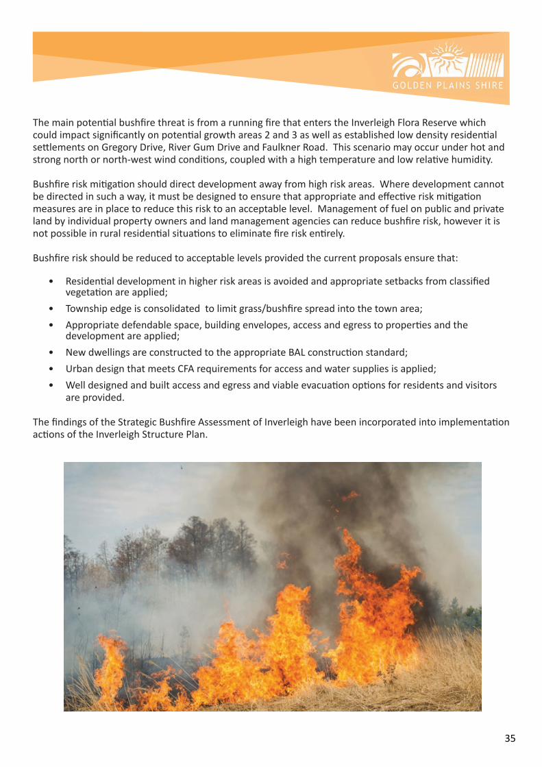
5.4.2 Bushfire
TheBushfireManagementOverlayappliestotheInverleighFloraReserve,theInverleighGolfCourseandextendsapproximately150metresintoprivatelandalongCommonRoadoppositetheInverleighFloraReserveandalsotheadjoiningparcelonHopesPlainsRoad.Thepurposeofthisoverlayistoprotectlifeandpropertyfrombushfireimpactbyapplyinganumberofdevelopmentcontrols.Itisimplementedinareaswherethebushfireriskishighduetohazardousbushfirecharacteristicssuchassteepslopesandforests.TheBushfireManagementOverlayidentifiesareaswherethebushfirehazardwarrantsbushfireprotectionmeasurestobeimplemented.Developmentshouldonlybepermittedwheretherisktolifeandpropertyfrombushfirecanbereducedtoanacceptablelevel.
AStrategicBushfireRiskAssessment(SeeAttachmentL)forInverleighhasbeenundertakentoinformtheInverleighStructurePlan.TheAssessmenthasconsideredthepotentialriskofbushfireimpactonthetownshipofInverleighandthepotentialgrowthareasidentified.Thepotentialresidentialgrowthareasareidentifiedinfigure8below.
Highfiredangerdayswithhightemperaturesandlowhumiditywithstrong,hotnorthornorthwesterlywindsfollowedbyastrong,coolerwesttosouthwestwindchangepresentthegreatestbushfirethreattothetownship.
Beingarurallandscape,thepotentialforignitionishigh.Theimpactofanyfireeventwillbedeterminedbyfuelloads,weather,preparednessandtheabilityofresourcestocombatafire.
Largefiresonhighfiredangerdaysrunningintothetownshipafteralongbuild-upthroughthesurroundinglandscapehavethepotentialtohavesignificantimpactonthetown.Smalllocalisedfiresignitingwithincloseproximitytothetownmaystillimpactthetownbutthesefirescanbeexpectedtobeeasiertobringundercontrolandexperiencefewerlosses.Thecentreoftownshouldprovidesuitablerefugeinallbutthemostextremefireconditions.
Figure 8 : Potential Growth Areas
35
ThemainpotentialbushfirethreatisfromarunningfirethatenterstheInverleighFloraReservewhichcouldimpactsignificantlyonpotentialgrowthareas2and3aswellasestablishedlowdensityresidentialsettlementsonGregoryDrive,RiverGumDriveandFaulknerRoad.Thisscenariomayoccurunderhotandstrongnorthornorth-westwindconditions,coupledwithahightemperatureandlowrelativehumidity.
Bushfireriskmitigationshoulddirectdevelopmentawayfromhighriskareas.Wheredevelopmentcannotbedirectedinsuchaway,itmustbedesignedtoensurethatappropriateandeffectiveriskmitigationmeasuresareinplacetoreducethisrisktoanacceptablelevel.Managementoffuelonpublicandprivatelandbyindividualpropertyownersandlandmanagementagenciescanreducebushfirerisk,howeveritisnotpossibleinruralresidentialsituationstoeliminatefireriskentirely.
Bushfireriskshouldbereducedtoacceptablelevelsprovidedthecurrentproposalsensurethat:
• Residentialdevelopmentinhigherriskareasisavoidedandappropriatesetbacksfromclassified vegetationareapplied;• Townshipedgeisconsolidatedtolimitgrass/bushfirespreadintothetownarea;• Appropriatedefendablespace,buildingenvelopes,accessandegresstopropertiesandthe developmentareapplied;• NewdwellingsareconstructedtotheappropriateBALconstructionstandard;• UrbandesignthatmeetsCFArequirementsforaccessandwatersuppliesisapplied;• Welldesignedandbuiltaccessandegressandviableevacuationoptionsforresidentsandvisitors areprovided.
ThefindingsoftheStrategicBushfireAssessmentofInverleighhavebeenincorporatedintoimplementationactionsoftheInverleighStructurePlan.

36
5.4.3 Erosion
Stateplanningpolicyseekstoprotectareaspronetoerosion,landsliporotherlanddegradationprocesses.
TheareawiththehighestlandslipriskinInverleighistheescarpmentarea,whichistoremainundeveloped.ThePublicParkandRecreationZoneshouldbeappliedtoareashavingpropensityforlandslipanderosion.Riskscanbefurthermitigatedthroughcontrolsappliedatsubdivisionstage.
HighwaterandfloodeventsinInverleighcanhaveimpactsontheriverbanksandcancausesevereerosionaroundtheriverenvironsincludingthewashingawayofpathsandtrails.
Likewise,stormwaterhasthepotentialtocreateerosionoftheriverbankifnotappropriatelymanagedaspartofthesubdivisiondesign,constructionandmaintenance.
5.4.4 Loss of biodiversity
StatePlanningpolicyseekstoassisttheprotectionandconservationofVictoria’sbiodiversityandconsidertheimpactsoflanduseanddevelopmentonthesevalues.TheStructurePlanhasbeenconsideredinrelationtoprotectingandconservingbiodiversity.
TheLeighandBarwonRiversprovidevaluableenvironmentalcorridorsthatneedtobeprotectedfromdevelopmentandpollutionassociatedwithstormwaterandsepticseepage.Theextensivefloodwayandfloodplainassistintheprotectionoftheseriverenvirons,asdoestheEnvironmentSignificanceOverlay2–WatercourseProtection.
Stateplanningpolicyseekstoprotectlandscapesandsignificantopenspacesthatcontributetothecharacter,identityandsustainableenvironments.TheStructurePlanprovidesforadditionalopenspacealongtheLeighRiveraspartoffutureresidentialdevelopmentoftheadjoiningland.AppropriatezoningtoPublicParkandRecreationZoneshouldbeappliedtotheseareas.
TheInverleighFloraReserve andGolfCourseshouldcontinuetobeprotectedboththroughplanningcontrols,includingbuffersandfiremanagementcontrols.Linksfromtheseareatothe‘oldtown’shouldbeprovidedintheformofgreencorridorsandpedestrianaccesstrails.
TheStructurePlanreinforcestheGreenBio-linkbetweentheInverleighFloraReserveandtheLeighRiver,designedtoprovidelandscapeamenitythroughtheresidentialareasandprovidealinkforthetransferofwildlifebetweentheCommon,thetownshipandtheLeighandBarwonRivers.
AdditionalGreenlinks,areindicatedontheStructurePlantoprovideconnectionsfromestablishedresidentialareasinthenorthtotheInverleighFloraReserveandfromtheFloraReservethroughproposedresidentialareas,southtotheLeighRiverandalongtheriverintothetownshipareaaswellasthroughthetownanddowntotheBarwonRiver.
Nativevegetationthroughnewresidentialareasshouldberetained,protectedandmaintainedbothforlandscapeamenityandprotectionofbiodiversity.

37
5.5 Residential
5.5.1 Settlement
TheInverleightowncentreadherestoaconventionalgridlayoutcontainingmainlyrectangularlotswithatleastoneroadfrontage.TheTownshipZoneappliesinthiscoretownshipareaorthe‘oldtownship’areandstraddlestheHamiltonHighway.AlargerproportionofthetownislocatedsouthofHighStreet,westoftheBarwonRiverandsouthoftheLeighRiver.TheTownshipZoneprovidesforresidentialdevelopmentandarangeofcommercial,industrialandotherusesinsmalltowns.Communityusescanalsobelocatedinthiszone.
Thetownshiporvillagehaslargelybeenconstrainedduetoanumberoffactors,includingflooding,lackofsewerageandtherailwayline,twoblockssouthandrunningparalleltotheHamiltonHighwaythroughthetown.Inthesouthwest,residentialgrowthofthetownshiphasbeenconstrainedbyanestablishedbroilerfarm,whichhasrecentlyceasedoperation.Aperiodoftwoyearsappliesbeforeexistinguserightsareextinguishedonthisproperty.
Figure 9: Inverleigh Feasibility Plan showing the broiler farm
Inte
nsiv
e Ag
ricul
ture
Intensive Agriculture
Intensive Agriculture
Inte
nsiv
e Ag
ricul
ture
1km from
Town Core
1km from Town Core
Town Core
Town Core
Legend
Land uses
Considerations/Opportunities
Movement
Site Features
Flood Region Boundary (1 AEP)
Native Vegetation Clusters (Unsurveyed)
Site Boundary
Rivers
Water Courses
1M Contour Intervals
Existing Building
Broiler Farm Building
Escarpment/Crests
Intensive Agriculture
Public Uses (as labeled)
Rail Infrastructure
Public Park and Recreation
Public Conservation & Resource
Potential Future Public Conservation & Resource Within Constrained Land
Sensitive Interface
Limited East West Connectivity
Constrained Key Access Roads into site from Hamilton Hwy
Township/Residential
Town Core
Low Density Residential
Consolidated LandownershipProperty Boundary
Highway
Sealed Road
Unsealed Road
Railway
Paper Roads (unconstructed)
Level Railway Crossing
Bridge Railway Crossing
Town Core 1km Catchment
Buffer to Intensive Agricultural Use
20 April 2018INVERLEIGH FEASIBILITY PLAN
Level 2, 6 Riverside Quay Southbank, VIC 3006 t 9695 3025 f 9695 3001
Opportunities and Constraints Plan Golden Planes Shire
Level 2, 6 Riverside Quay Southbank, VIC 3006 t 9695 3025 f 9695 3001
N
5000
100 200 5000
at A31: at A1 1: 10000Sheet of 11
Inverleigh Recreation
Reserve
Victoria ParkCemeteryCemetery RdCemetery Rd
Terr
ier R
d
Terr
ier R
d
Fulle
r Rd
Gib
son
Rd
McC
allu
m R
d
Rive
rvie
w R
d
Phill
ips
Rd
McCallum Rd
Park St
Mercer St
Napier St
Railway St
River RdGal
lagh
er R
d
Days Rd
Morgan Rd
Mah
ers
Rd
Mah
ers
Rd
Broiler Farm
Inverleigh PrimarySchool
SchoolWoodlot
Leigh River
FormerInverleigh
Train Station

38
SincetheISP2005,significantpolicychangehasoccurredwithregardtotheLowDensityResidentialZone.Thepolicyof1hectareminimumlotsizehasbeenreplacedwithaminimumlotsizeof4000m2or0.4hectare.ThisisconsistentwithStatePlanningpolicytomakemoreefficientuseofresidentialzonedlandandthefindingsofCouncil’sDomesticWastewaterManagementPlan2015,whichincludedthattheappropriateminimumlotsizeforun-seweredresidentialdevelopmentintheShireis0.4hectares.
TheimplicationsofthepolicychangeforInverleighwillbetoremovethestipulatedminimumlotsizeof1-2hectaresfromtheInverleighStructurePlan.TheeffectwillbethatforareaszonedLowDensityResidentialZone,theminimumlotsizewilldefaulttotheStatePlanningminimumlotsizeof0.4ha.
TheresultofthischangeonthesettlementpatternofInverleighwillmostlikelybeevidentinGreenfielddevelopmentareasthatwilldevelopatahigherdensitythanhasoccurredthroughtheexistinglowdensityresidentialareatothenorthofthetown.AvarietyofplanningtoolshavebeenusedandwillcontinuetobeappliedtothelowdensityresidentialareasofInverleigh,suchasprotectionandretentionofmaturetrees,andtheapplicationoftheDesignandDevelopmentOverlaySchedule5toensurethecharacterismaintainedandthereisasenseofspacebetweenbuildingsrequiredthroughbuildingsetbacks.
Furthermore,landscapeandtopographicfeaturesandthevisualandhistoric/culturalcharacteristicsshouldbeusedtoguidethepatternofstreetsandpublicspacesandincorporatedintoviewswhereappropriate.AnumberofcovenantsapplytoexistinglowdensityresidentialsubdivisionsthroughoutthenorthernpartofInverleighwhichwillrestrictsubdivisionpotentialandinfilldevelopmentoftheselots.
5.5.2 Supply and demand
StatePlanningPolicyrequiresCounciltoensureasufficientsupplyofurbanlandisavailableforresidential,commercial,retail,industrial,recreational,institutionalandothercommunityuses.
Planningisrequiredtoensurethereissufficientlandavailabletomeetforecastdemandandtoplantoaccommodateprojectedpopulationgrowthoveratleasta15yearperiodprovidingcleardirectiononlocationswheregrowthshouldoccur.Thesamepolicyalsorequiresthatlowdensityresidentialdevelopmentisconsideredinrelationtoitsimpactonfuturehigherdensitydevelopment.Asanun-seweredsmalltown,Inverleighisrestrictedtolowdensitydevelopment.
FromtheoutsetofundertakingthenewInverleighStructurePlan,CouncilhighlightedthatitwasconsideringhowtoefficientlymanagepopulationgrowthwithintheexistinggrowthboundaryfromtheISP2005.ItwasalsoindicatedthatthenewStructurePlanwouldincorporatefindingsoftheInverleighFloodStudy.
Onthematterofsupply,theremainingunzonedlandidentifiedforpotentialfutureresidentialdevelopmentinthenorthofthetownequatestoaround350ha.Anestimatedlowdensityresidentiallotyieldof525lotsiscalculatedbasedon40%ofthelandbeingusedforroadsandopenspaceandtheminimumlotsizeof0.4ha.
Withanexpecteddemandforatleast430newhouses,thelandidentifiedforfuturelowdensityresidentialgrowthinthenorthofInverleighwillcaterfortheanticipatedpopulationandhousinggrowthoverthenext
39
20years(calculatedusing27newhousesperannum).Subdivisionintolargerlots(inexcessof0.4hectares)duetofactorssuchaslandcapabilityorenvironmentalconstraints,wouldchangethesupplyfigures.
Additionallandhasbeenidentifiedinthesouthwestofthetownshipasa‘FutureInvestigationArea’.ThelandiszonedFarmingbutisfragmentedintolotssizedbetween2-4hectares.Thisfragmentationputsthesiteatriskofad-hocdevelopmentandpotentiallymakesthecoordinationofinfrastructuredeliveryandupgradesproblematic.ConsiderationofalternativezonesforthislandhasbeenundertakenaswellasaDevelopmentFeasibilityStudy,providedinAttachmentK,thisstudylookedatvariouslotsizescenariosforthearea,andfoundthatselectinganalternativezoneishinderedbyanumberoffactorsincluding:
• thedifficultlyforlandowners/developerstofundnecessaryinfrastructureeffectivelydiscouraging residentialintensification;
• therisktoCouncilofhavingtofundthecostofinfrastructureprovisiontothearea;
• thelikelyad-hocresidentialintensificationofthesiteandthedifficultlyapportioningcostof developmentwiththisapproach.
Duetothelargenumberofseparatelandowners,infrastructureandenvironmentalconstraints,therailwaylineandassociatedcrossings,thelandislessconducivetodevelopmentintheshorttomediumterm. DirectlysouthofthetownshipandwrappingaroundtheInverleighRecreationReserve,theextensionofthetownisidentifiedintheformofthelowdensityresidentiallotpattern.OpportunityforthiswascreatedwiththeclosureoftheexistingbroilerfarminMcCallumRoad.WhentheexistinguserightsofthisbroilerfarmexpireinMay2020,thelandcanberezonedtofacilitatesubdivisiondownto0.4ha,effectivelyhedgingthetownonthewesttoincorporatetheRecreationReserveandVictoriaPark.Potentialyieldfromthisrezoningiscalculatedataround22lots,whichislessthan1yearsupplyandprovidesanalternativeproducttotheresidentialdevelopmentinthenorth,thisareacandeliverbenefitstothewholeofInverleighwithresidentialgrowthincloseproximitytothetowncentreandpotentialforimprovedinterfacetreatmentsandconnectivitywiththerecreationreserveandVictoriaPark.

40
5.6 Natural Environment and Open Space
Inverleighisabundantwithnaturalfeaturesincludingtheriverenvirons,theInverleighFloraReserve,rurallandscapes,remnantnativevegetation,includingmanyoldMannagumsandRiverRedgums.Thesecreateadistinctivenaturalenvironmentthathasbeenrespectedwithinthelandusedevelopmentofthetownandutilisedwithinthetown’sopenspaces.
ThetownsitswithintheenvironmentallysensitivefloodplainoftheLeighandBarwonRivers.TheescarpmentonthenorthernsideoftheLeighRiverprovidesadramaticbackdroptothetown.TheLeighRiverinparticularprovidesopportunitiestoexperiencenaturewithinashortwalkofthetowncentre.Recreationalareasalongtheriverandlandcareactivitiesreinforcetheimportanceofthiswaterway.
TheLandSubjecttoInundationOverlayandFloodOverlayapplytoextensiveareasoftheInverleightownshipassociatedwiththeconfluenceoftheLeighandBarwonRiversaroundthetownship.Growthdirectlyaroundthetownshipisrestrictedbythefloodrisksinthetownship.TheInverleighFloodStudy2018wasrecentlycompletedandrevisesthemappingofthefloodoverlays.ThenewflooddatahasbeenutilisedinthepreparationoftheInverleighStructurePlan2019.
ThePublicConservationandResourceZone(PCRZandEnvironmentalSignificanceOverlay,Schedule2appliestotheLeighandBarwonRiverareasandaimstoprotectandconservethenaturalenvironmentandnaturalprocessesfortheirhistoric,scientific,landscape,habitatorculturalvalues.Thepurposeisalsotoprovidefacilitieswhichassistinpubliceducationandinterpretationofthenaturalenvironmentwithminimaldegradationofthenaturalenvironmentornaturalprocesses(GoldenPlainsPlanningScheme.
ProtectionoftheLeighandBarwonRiversforbiodiversityandopenspaceisreinforcedintheStructurePlan,LandscapeandOpenSpacePlanaswellasthevisionandprinciples(SeeAttachmentG.Theprotectionoftheviabilityandfunctionofexistingnaturalecosystemsisaprioritywhenconsideringtheinterfaceoftheseareaswithresidentialdevelopment.
ParksVictoriamanagestheInverleighFloraReserve.TheReserve,whichislocatednorthwestofthetownisaccessibletothepublicthroughaseriesoftrailsandsupportsextensivenativefloraandfauna.TheReserveiszonedPCRZ.AsmallpartofCrownlandhasbeendevelopedastheInverleighGolfCourse,whichstillcontainssubstantialindigenousvegetation.TheGolfCourseisgovernedbyaCommitteeofManagementandiszonedPublicUseZone7torecognisepubliclanduseforpublicutilityandcommunityservicesandfacilities.TheFloraReserveandGolfCoursecontinuetobeprotectedthroughtheStructurePlanwithinterfaceandbushfiremanagementtreatmentstomanagetheinterfacewithadjoiningareasproposedforlowdensityresidentialdevelopment.
ToconnecttheFloraReservewiththeLeighRiver,aGreenLinkbetweenthetwolocationswasestablishedusingopenspacecontributions.TheGreenLinkistoberetainedasapedestrianlinkandadditionallinksareidentifiedintheFutureInvestigationAreasouthofCommonRoad,forbothpedestrianaccessaswellasthemovementofwildlifebetweentheFloraReserve,theLeighandBarwonriversandthetownshipofInverleigh.

41
Inverleigh Bio-link Proposal
Abio-link(linearlinksforbiodiversity)ofasuitablewidthistobeprovidedaspartoftheproposedfuturerezoninganddevelopmentoflandinCommonRoad.Thelocationandwidthofthebio-linkshouldbedeterminedaspartoftherezoningandsubdivisionstages.Thebio-linkshouldbedesignedtocaterforthevarietyoffaunaintheareaaswellastheoverallecologicalfunctioningofthereserveandriversystems.Apreferredapproachisfortwolinearlinks.Onebeingamultipurpose,greenlinearlinkinthemiddleareaoftheFutureInvestigationAreaonCommonRoadprovidingforpedestrian,emergencyandwildlifeaccess.Theotherasasingleuseecologicalbio-linkonthewesternboundary.Bothlinksshouldincludevehicleaccessformaintenancepurposes,mowingandburning.Thiswillberequiredforthefirstfewyearsduringestablishmentandforongoingfireprotectionmeasures.
AperformancebasedapproachdependentonthepurposeofthelinkshoulddeterminethewidthoftheBio-link.AnappropriatewidthshouldbedeterminedatrezoningstageinconsultationwiththeDepartmentofEnvironment,Land,WaterandPlanningandParksVictoria.

42
TheInverleighStructurePlanprovidesforanetworkofwelldistributedandconnectedopenspacescateringforabroadrangeofusesthatincludesopenspaceandnaturereserves,suchastheFloraReserve,GolfCourse,localparksincludingLawson’sParkandVictoriaParkwithinthetowncentre,activeopenspaceinproximitytotheprimaryschoolandtowncentreaswellasarangeoflinearparksandtrails,mostlyalongwaterways,butalsolinkedtovegetationcorridorsandroadreserves.LawsonsPark,VictoriaParkandtheRecreationReservearezonedPublicParkandRecreationalZonetorecognisetheseareasaspublicrecreationandopenspaces.
AkeyfeatureoftheInverleighStructurePlanistolinkopenspacestopedestrianandcyclepathsandalsotoprovideconnectedbridletrailsforhorseriding,whichcanbesharedwithpedestrianandcyclepathsalso.Asthetowncontinuestogrow,itisimportanttoconsiderhowtoembednaturalplayspaceandconnectivityintosubdivisiondesign,withoutreliance on the car.
AnewCommunityPlaySpaceprovidingformulti-agegroupshasreceivedfundingandwillbebuiltadjacenttotheexistingtoiletfacilitiesandskateparkonthesouthernsideofbridge,closetothetownandadjacenttotheLeighRiver.
Largeplayfacilitiesintownandintegratedwithcommunityfacilitiesisthepreferredmodelforformalplayfacilitiesratherthanpocketparksinsubdivisions.ThisreinforcesthevisionforInverleighasameetingplace.Informalnaturalspacesshouldbeintegratedintosubdivisiondesignproviding‘incidentalplay’opportunitiesandwildnaturepocketstogetherwithsafetravelroutessothatchildrenareencouragedtowalkandcycleindependentlytoschoolandrecreationfacilities.
Futureactiveopenspacesshouldbeco-locatedandsharedandintegratedwithcommunityfacilitieswherepossible.AllocationoffutureopenspacehasbeenidentifiedadjacenttotheexistingRecreationReserve.LowDensityResidentiallandusearoundthisshouldbedesignedtomaximisepassivesurveillanceofthispublicopenspacearea.
AvenuetreesalongtheHamiltonHighwayandindividualtreesinthemainstreetprovideastrongsenseofarrivalandidentity.
43
5.7 Community Facilities
ExpansionoftheRecreationReserveisprovidedforwithintheStructurePlan.Currentlythelandisusedforfootball,cricket,netballandlawnbowlswithassociatedclubrooms.AsecondovalhasbeenprovidedsincethelastStructurePlan.Additionalfacilitieswhichmayberequiredinthefutureincludenewtenniscourtsco-locatedontheRecreationReserveandasoccerpitch.
LandtothewestoftheRecreationreserveisidentifiedshouldadditionallandberequired.ThelandisprivatelyownedandshouldbeconsideredforPublicOpenSpaceaspartoftheexpansionoftheresidentialareawestofthetownshipthroughtoPhillipsRoad.FutureresidentialdevelopmentshouldintegrateandincorporatetheRecreationReserveaswellaslinkwiththeexistingtownship.
TherelocationofthetenniscourtsfromthesiteadjacenttothePrimarySchooltotheRecreationReservewillprovidegrowingspacefortheschoolandconsolidatesportingactivitiesandclubsprovidingopportunitiesforsharingoffacilities.Therelocationishamperedbythecostofprovidingnewtenniscourtsandalackoffundingopportunitiesfortennisfacilities.
VictoriaParkprovidesforarangeofalternativecommunityrecreationuses,suchasequestrian,dogrelated,informalplayandotherusesthatfalloutsideofthefootball,cricket,netballtypesportswhichareprovidedforattheRecreationReserve.ThecommunitywouldliketoseeVictoriaParkretainedinitsentiretyforpublicopenspace.Thereareplanstoredeveloptheclubroomsandcontinuetomakethespaceavailableforcommunitygroups,eventsandequestrianrelatedactivities.
LawsonsParkhasplayequipmentandisusedformarkets.ThepublictoiletsarelocatedonthesouthernsideoftheHamiltonHighwayandaccessisprovidedunderthebridgefromLawsonsPark.AcommunityinitiativehasbeensuccessfulinobtainingfundingfortheadditionofnewplayequipmentintheopenspaceonthesouthernsideoftheHamiltonHighwayandbridgeincloserproximitytothepublictoilets.ThisissupportedintheStructurePlan.
Inverleighhassubstantialopenspace;comprisedofamixoffreeholdandcrownland,alongtheLeighRivercorridortothejunctionwiththeBarwonRivertothesouthofthetown.Thesereservesprovidespaceforrecreation(e.g.walking,biking,horseriding)andalsoservetoconserveimportantriverinehabitat.CampingisallowedaroundtheBarwonandLeighRiverjunctionwhereCouncilismaintainingalowimpactapproachtomanagingthisuse.Considerablecommunityrevegetationalongtherivershasimprovedtheamenityandconservationvalueofthesereserves.
TherearenoplansforrelocationoftheInverleighPrimarySchoolfromitscurrentsite.Theschoolisrelativelyconstrainedintermsofenablinggrowth.TheInverleighPrimarySchoolhasbeenworkingwithCouncilandtheadjoiningchurchtouseneighbouringlandforexpansionoftheschoolgrounds.Variousoptionscouldbeconsideredforthefutureofthesiteincludingadditionalportables.AdditionallandwouldbeavailablewiththerelocationofthetenniscourtstotheInverleighRecreationReserve.TheSchoolWoodlot,locatedonMcCallumRoadandRailwayStreet,inthesouthofthetownshipisownedbytheDepartmentofEducationandprovidesopportunityforexpansionoftheschool,ifrequired.Alloptionsrequireconsiderationoftheschoolsetting,siteconstraints,schoolprogramsandoperationsaswellaspotentialjointusearrangements.
EarlychildhoodservicesprovideforafouryearoldkindergartenprogramandalimitedOccasionalCareserviceatthekindergartenfacilityontheInverleigh-WinchelseaRoad.Alongtermoptionistoco-locatewiththePrimarySchool.

44
Anyfuturecommunitybasedfacilitiesshouldbelocatedandintegratedintotheexisting‘oldtownshiparea’.Co-locationandintegrationwithexistingcommunityfacilitiesshouldbeencouraged,althoughfloodimplicationsandthelackofreticulatedseweragemustbeconsidered.
5.8 Cultural and Built Heritage
ThestrongvillagecharacteroftheInverleightownshipiscreatedthroughthedistinctnaturalfeaturesofthetownincludingtheriversandculturalfeaturesincludingthemanyhistoricbuildings,particularlyinthemainstreetandtowncentrewhichformpartofaheritageprecinctprotectedthroughaHeritageOverlayintheplanningscheme.
TherearealsoseveralsitesofAboriginalculturalsignificancewhichhavebeenidentifiedalongtheriversandthroughthetown.TheWadawurrungistheRegisteredAboriginalParty.Areasofculturalheritagesensitivityaremappedandsubdivisionorcertaintypesofdevelopmentinthismappedarearequiresappropriateinvestigationandmanagementplans.
AreasretainedforAboriginalculturalandpost-contactheritageformanimportantpartofthetowncharacterandstronglycontributetotheappeal,culturalvaluesandappearanceofthetown.AppropriatetransitionsandbuffersshouldbeprovidedbetweenareasofsignificantAboriginalculturalheritagevalueandurbanlanduses.
Togetherwiththeenvironmentalqualities,theculturalandbuiltheritageprovidearich,organicandhistoricidentitywhichcontributetoInverleigh’sstrongsenseofplace.AHeritagePlanisprovidedatAttachmentF.
Figure10belowshoestheHeritagePrecinctwhichisprotectedthroughtheGoldenPlainsPlanningScheme.
Figure 10: Inverleigh Heritage Precinct Map
Growthofthetownshipoverthelast20yearshasbeenpredominantlynorthoftheLeighRiveralongCommonRoadwherethesettlementpatternhasbeenofaruralresidentialcharacterwithfamilysizedhousesandlargegardens.TheLowDensityResidentialZoneappliestotheseareaswherethereisanabsenceofreticulatedsewerage.
45
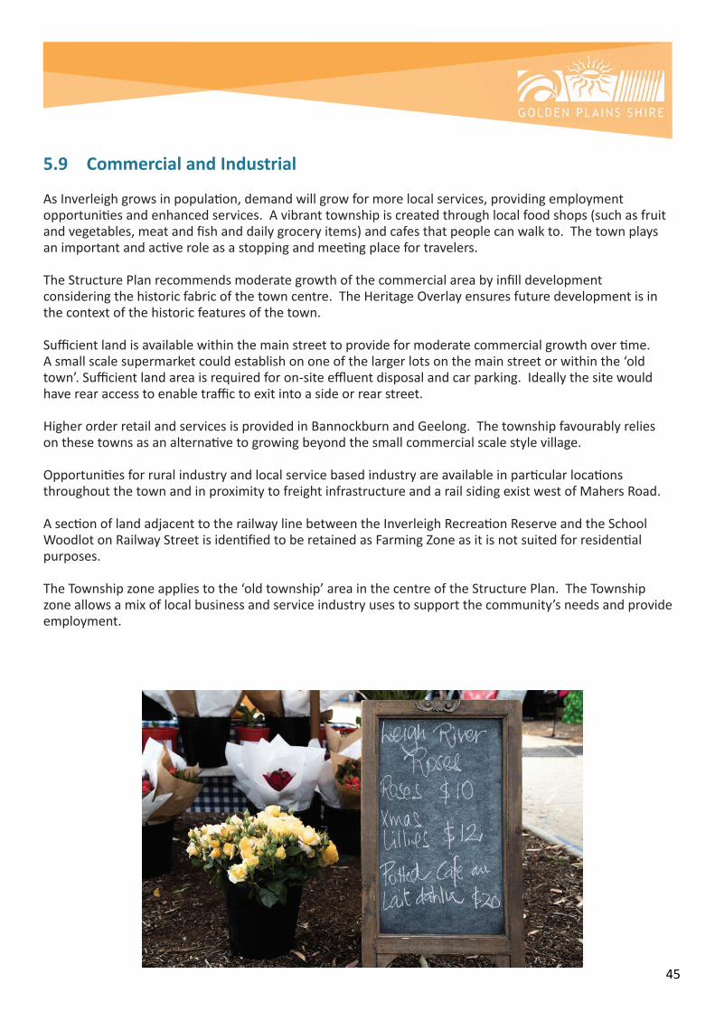
5.9 Commercial and Industrial
AsInverleighgrowsinpopulation,demandwillgrowformorelocalservices,providingemploymentopportunitiesandenhancedservices.Avibranttownshipiscreatedthroughlocalfoodshops(suchasfruitandvegetables,meatandfishanddailygroceryitems)andcafesthatpeoplecanwalkto.Thetownplaysanimportantandactiveroleasastoppingandmeetingplacefortravelers.
TheStructurePlanrecommendsmoderategrowthofthecommercialareabyinfilldevelopmentconsideringthehistoricfabricofthetowncentre.TheHeritageOverlayensuresfuturedevelopmentisinthecontextofthehistoricfeaturesofthetown.
Sufficientlandisavailablewithinthemainstreettoprovideformoderatecommercialgrowthovertime.Asmallscalesupermarketcouldestablishononeofthelargerlotsonthemainstreetorwithinthe‘oldtown’.Sufficientlandareaisrequiredforon-siteeffluentdisposalandcarparking.Ideallythesitewouldhaverearaccesstoenabletraffictoexitintoasideorrearstreet.
HigherorderretailandservicesisprovidedinBannockburnandGeelong.Thetownshipfavourablyreliesonthesetownsasanalternativetogrowingbeyondthesmallcommercialscalestylevillage.
OpportunitiesforruralindustryandlocalservicebasedindustryareavailableinparticularlocationsthroughoutthetownandinproximitytofreightinfrastructureandarailsidingexistwestofMahersRoad.
AsectionoflandadjacenttotherailwaylinebetweentheInverleighRecreationReserveandtheSchoolWoodlotonRailwayStreetisidentifiedtoberetainedasFarmingZoneasitisnotsuitedforresidentialpurposes.
TheTownshipzoneappliestothe‘oldtownship’areainthecentreoftheStructurePlan.TheTownshipzoneallowsamixoflocalbusinessandserviceindustryusestosupportthecommunity’sneedsandprovideemployment.

46
5.10 Agriculture
Inverleighisavillageinaruralsettingandisrecognisedasthegatewaytothewesterndistrict.Thetownshipcatersforthewiderruralcommunityandhasstrongruralcharacteristicsandvaluesstemmingfromitshistoricroleasaruralservicetownship.Thisroleisexpectedtocontinueandbesupportedintothefuture.
Agriculturalusesexistingwithinandaroundthetownship,includingextensiveanimalhusbandry,cropraising,horticulture,livestockfarmingandshearingservices,playanimportantroleinInverleigh’seconomy,withatotalof540Agriculturalbusinessesbothwithinthetownshipanditssurrounds.
TheFarmingZoneappliestolandsurroundingthetownshipandalsoappliestoareaswithinthetownshipboundary.Thiszonereflectsthehistoricfarminguseoftheland.ProtectionofInverleigh’sagriculturalbaseandindustriesintothefutureistobesupportedthroughappropriatebuffersandinterfacetreatmentswiththetownshipandresidentialdevelopmentontheedges.
TheobjectiveoftheFarmingZoneistouseandretainlandforagricultureandaminimumsubdivisionsizeof100hectaresapplies(GoldenPlainsPlanningScheme).TypicallylandzonedFarmingZonearoundInverleighisusedforcroppingandgrazing.ThisalsoappliestoareaswithinthetownshipboundarytothenorthoftheHamiltonHighway.AreaszonedFarmingtothesouthoftheHamiltonHighwayandwithinthetownshipboundaryaremorefragmentedandarecharacteristicallyrurallivingsizedallotmentsofmostly4hainagridpattern.ConsiderationofalternativezonesforthisareawaspartoftheDevelopmentFeasibilityStudyPackage–InvestigationAreaintheTownshipofInverleigh,October2017(SeeAttachmentK).TheFarmingZonehere,servesas‘holdingzone’untilconsiderationcanbegiventoresidentialproposalswithsufficientevidenceoffeasibilityandsuitabilityforthissiteareprovidedbylandowners.
5.11 Developer Contributions
Thecoordinatedandtimelydeliveryofcriticalinfrastructureiskeytothesuccessfulcontinuedgrowthofthetownship.Involvingagenciesandserviceprovidersearlyandthroughouttheprocesswillhelpresolveanyissuesthatcouldimpactondelivery.
Theprovisionofinfrastructuretoservicelandisgenerallyconsideredatrezoningandagainatplanningpermitstage.Agreementsbetweendevelopersand/oragenciesarerequiredatrezoningstagetoensurethattheinfrastructureitemsaresatisfactorilyaddressedasdevelopmentproceeds.AnInfrastructureContributionsPlan(ICP)oraSection173Agreementarepotentialmechanismsforcollectinginfrastructurecontributionsinrelationtothedevelopmentofland.TheICPsystemisbasedonstandardlevysthatarepresetwithparticulardevelopmentsettingsandlandusesinordertofundtheprovisionofessentialinfrastructuretosupportgrowingcommunities.ALandContributionModelisexpectedtobedevelopedforregionalgrowthareasandstrategicdevelopmentareasasaStateGovernmentinitiative.Thismayprovidetheappropriatetoolforcollectionofinfrastructurecontributions.IntheabsenceofanICP,agreementswillneedtobesecuredtoensurethecoordinatedandtimelydeliveryofinfrastructure.
Asuccessfulandvibrantcommunityrequiresarangeofcommunity,transportandotherinfrastructureandservicestoallowallmemberstoactivelyparticipateinemployment,shopping,andsocial,recreationandotheractivities.Ideally,afullrangeofserviceswouldbeprovidedlocally,butifthesearenotlocal,theyshouldbereadilyaccessiblewithintheregionofnearbytowns.

47
Continuedmoderategrowthofthetownwillgeneratearequirementforawiderangeoflocalinfrastructureincludingintersectiontreatments,upgradeofthetwinbridges,expansionofthekindergartenservice,ovals,potentialrelocationofthetenniscourtsandextensionofthetrailsandopenspacenetwork.AkeypartofplanningthisinfrastructureandservicesrequirescollaborationandformalisedagreementsbetweenCouncil,developersandrelevantagencies.
List of infrastructure upgrades required for the continued growth of the township:• Intersectionupgradesandstreetlightingupgradesat: -HopesPlainsRoad/HamiltonHighway -CommonRoad/HamiltonHighway• AccessManagementPlanfortheFutureInvestigationAreatothesatisfactionofVicRoads;• Upgradeorreplacementoftwinbridgestoaminimum15tonnecapacitybridgeoralternativeaccessforemergencyvehiclestocrosstheLeighRiverforaccesstoCommonRoad;•PotentialforasatelliteCFAshedforfirefightingvehiclesduringfireseason;•Staticwatersupplyof2x55,000litrewaterstorageforfirefightingpurposes;• PedestrianlinkalongtheHamiltonHighwaylinkingHopesPlainsRoadtothetowncentre;• Bridlepaths;• Greenlinksandpedestrianlinks;• Bio-linkfromInverleighFloraReservetoLeighRiver;• Relocationoftenniscourtstorecreationreserve;• Gatewaytreatments;• Bushapproachestoentrances;• BushfiremanagementaspertheStrategicBushfireRiskAssessmentforInverleigh.
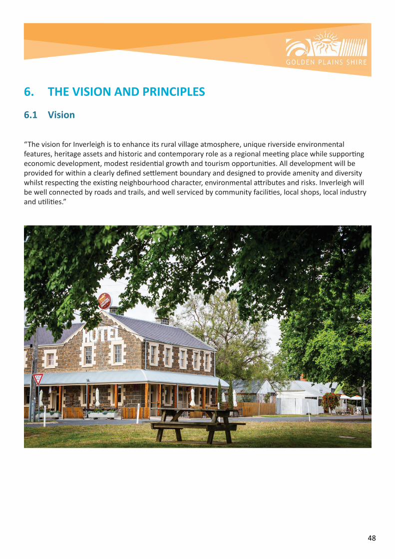
48
6. THE VISION AND PRINCIPLES
6.1 Vision
“ThevisionforInverleighistoenhanceitsruralvillageatmosphere,uniqueriversideenvironmentalfeatures,heritageassetsandhistoricandcontemporaryroleasaregionalmeetingplacewhilesupportingeconomicdevelopment,modestresidentialgrowthandtourismopportunities.Alldevelopmentwillbeprovidedforwithinaclearlydefinedsettlementboundaryanddesignedtoprovideamenityanddiversitywhilstrespectingtheexistingneighbourhoodcharacter,environmentalattributesandrisks.Inverleighwillbewellconnectedbyroadsandtrails,andwellservicedbycommunityfacilities,localshops,localindustryandutilities.”

49
Principles Objectives Strategies
(a) An enduring settlement boundaryThenaturalfeaturesoftherivers,the InverleighFloraReserveandvegetationalongwithphysicalfeaturessuchasroads,willformanenduringsettlementboundaryaroundInverleigh.
(b) Planned and orderly growthInverleigh’sgrowthwillbecarefullyplannedtoensurethatappropriateinfrastructureandamenityisprovidedasrequiredandtoavoidunplannedrezoningandpotentialad-hocsubdivision.
•TomaintainInverleigh’svillageatmospherewithmoderategrowthwithinthetownshipboundary.
•ToholisticallyplanforgrowthovertimethatwillmakeapositivecontributiontoInverleigh’sliveabilityandcharacterincludingthenaturalenvironment,anditspublicrealm.
•Toretainthetown’scentrecoreasthemaincommercialandretailprecinct.
•ToenhancethetownshipgatewaysandstreetscapeswhichwillservetodefinetheentriestoInverleighandsenseofplace.
•Containresidentialgrowthwithintheexistingdefinedtownshipboundary.
•Ensureareassuitabletoaccommodateintensificationaredesignedtoincorporateandprotectthesenseofspaceandimportantnaturalfeaturessuchastopography,viewlines,remnantvegetation,roadsidevegetationandwatercourses.
•EncouragecommercialdevelopmenttobeconsolidatedwithintheexistingtowncentreofInverleighthroughinfilldevelopment.Thisextendstocommunityandsocialfacilities.
•Promotetheredevelopmentofunderutilisedsitesandwherepossible,theretrofittingofexistingbuildingstoprovideforcommercialorofficeuses.
•Ensureaclearseparationbetweenurbandevelopmentandfarmingactivitesisretained.
•Protecttheenvironmentalandlandscapefeaturesandviews,includingtheBarwonandLeighriverenvirons.
SETTLEMENT FORM
See:Attachment BInverleigh Structure Plan - Settlement Boundary
See:Attachment DInverleigh Structure Plan - Zoning and Land Use
50
Principles Objectives Strategies
(a) Admired heritage featuresInverleigh’sculturalheritage,heritageprecinctandotherheritagesites(includingLulloteHomestead)willbepreservedandenhancedwithheritagefeatureshighlightedtoencouragetourismandplacemaking.
•Retainthevillageatmosphereandroleofthetowncentreasameetingplace.
•Provideformoderategrowthwithinthetownboundariesthatrespectstheenvironmental,historicandruralcontextofthetownship.
•PreserveandenhanceInverleigh’sculturalheritage,heritageprecinctandotherheritagesites(includingLulloteHomestead)andhighlightheritagefeaturesfortourismandplacemaking
•Improvetheattractivenessandamenityofthetown centre.
•Supportstreetscapeimprovements.
•Retainlowbuildingheightsthroughoutthetownship.
•Maintainandencourageasenseofspaciousnesswithadominanceoflandscapeoverbuiltforminlowdensityresidentialareas.
•Ensureanynewdevelopmentinthemainstreetcomplementsthecharacterofthetowncentrecore,inparticularinregardstoitsheritageplaces,predominantlysingle-storeyshops,consistentstreetsetbacks,materialsandroofforms.
•Conserveandenhancethoseelementsthatcontributetotheenvironmentalsignificance,heritagevaluesandcountrylifestylecharacterofthearea.
BUILT ENVIRONMENT, HERITAGE & CHARACTER
See:Attachment FInverleigh Structure Plan - Heritage Plan
51
Principles Objectives Strategies
(a) Residential development that responds to the landscapeResidentialdevelopmentwillcontinuetoincorporatetheexistinglandscapeasadesignobjectivethroughmaximisingtheretentionoflandscapefeaturessuchastrees,ridgelinesandwaterwaysandusinglargerlotswherenecessarytoachievethisoutcome.
(b) Town improvement through growthNewresidentialdevelopmentwillallowforimprovedvehicleaccess,sharedpathconnections,additionalpublicopenspaceandimprovedcommunityandrecreationfacilities. (c) A bushfire ready communityResidentialneighbourhoodswillbeappropriatelydesignedinresponsetoidentifiedbushfirebuffers,throughbuildingdesignandlocation,aswellastheprovisionofmultipleroadaccessopportunities.
•Containresidentialgrowthwithintheexistingdefinedtownshipboundary.
•Ensureclearlydefinedanddefendableboundariesandavoidareasofhighbushfireriskandflooding
•PlanfornewresidentialdevelopmentwhichrespondsandcontributestotheoverallcharacterofInverleigh.
Potentialamenity,environmentandbushfirerisksassociatedwithinterfacesofnewresidentialareaswiththeruraledgeofthetownshipandwithbiolinks,riversandescarpmentsshouldbeidentifiedaspartofresidentialdevelopmentatrezoningandsubdivisionstages.
•Bufferstoagriculturalpracticesthatmaycontributeodour,noiseanddustimpacts;
•Bufferstoagriculturalpracticesthatmayusechemicalssuchaspesticidesandweedkillers;
•Protectionoflivestockandnativefaunaspeciesfromdomesticandferalanimals;
*Protectionoftheviabilityandfunctionofexistingnaturalecosystems
•PlanfornewresidentialdevelopmenttoprovideadiverserangeoflotsizeswhichreflectsthecountrylifestylecharacterofInverleighandrespondstositeconditions.
•Encouragelowdensityhousingtypesgenerallyintheformofdetachedhousing.
•Provisionbemadeforgeneroussetbacksfromfrontandsideboundariestoprovidetheopportunityforsubstantiallandscapingwherebushfireriskislow.
•Encouragenewdwellingstobesetbackfromallboundariesasufficientdistancetoaccommodateadequatelandscapingandtomaintainthesenseofspaciousness.
•Protectkeyviewsandvistastotheruralsurroundsandencouragetheretentionoftreesandplantingofnewcanopytrees,wherebushfireriskislow.
•Supportrezoninglandwithinthetownshipboundarythatisunencumberedbyfloodingtofacilitateresidentialdevelopmentthatincorporatessubdivisionanddevelopmentdesignwhich:
RESIDENTIAL DEVELOPMENT
See:Attachment A:Inverleigh Framework Plan

52
Principles Objectives Strategies
o Hasregardtothelandform, environment,visualand historicalsensitivitiesofthe site;
o Proposeslotsizesand developmentoutcomes thatareinaccordancewithdomesticwastewater managementrequirements
o inaccordancewiththe InverleighStrategicBushfire AssessmentaswellasCFA requirements
o Deliverslowscaleand sensitivebuiltforminthe contextoftheenvironmental andhistoricassets;
o Providesforaccessin accordancewiththe MovementNetwork(Roads andPaths)Planaspartof theInverleighStructurePlan 2019.
• Directfuturegrowthofthetownshipawayfromdesignatedfloodplains.
• Encourageresidentialdevelopmentinsuitableareasclosetothetowncentreorareaswithgoodaccesstothe town centre.
• Residentialneighbourhoodswillbeappropriatelydesignedinresponsetoidentifiedbushfirebuffersandmitigationmeasuresaswellastheprovisionofmultipleroadaccessopportunities.
RESIDENTIAL DEVELOPMENT (CONTINUED)
See:Attachment E:Inverleigh Structure Plan - Neighbourhood and Character
See:Attachment J:Inverleigh Structure Plan - Movement and Access
53
Principles Objectives Strategies
•Potentialamenity,environmentandbushfirerisksassociatedwithinterfacesofnewresidentialareaswiththeruraledgeofthetownshipandwithbiolinks,riversandescarpmentsshouldbeidentifiedaspartofresidentialdevelopmentatrezoningandsubdivisionstages.
oBufferstoagriculturalpracticesthatmaycontributeodour,noiseanddustimpacts;
oBufferstoagriculturalpracticesthatmayusechemicalssuchaspesticidesandweedkillers;
oProtectionoflivestockandnativefaunaspeciesfromdomesticandferalanimals;
oAssessmentoffuelloads(agricultural,grasslands,biolinksandstreamside)andvegetation,slopeandprevailingwinddirectionsindesignofresidentialareas;
oCreationoffirebreaksandfuelreductionandminimizationusingappropriateplantingandmanagementguidelines.
RESIDENTIAL DEVELOPMENT (CONTINUED)
See:Attachment E:Inverleigh Structure Plan - Neighbourhood and Character
See:Attachment J:Inverleigh Structure Plan - Movement and Access

54
Principles Objectives Strategies
(a) A river townTheBarwonRiverandLeighRiverarefundamentalelementsofInverleighandwillcontinuetobecelebratedandusedasasettingforeventsandleisure.AstheInverleighpopulationincreasesandthetownbecomesbigger,theriversmustbeprotectedandwherepossibleplacedinpublicownership.
(b) Utilised open spaceNewandimprovedconnectionsandrelationshipstoopenspacewillbeprovidedtoensurethewholecommunityhasaccess.
•Providefornewandimprovedconnectionsandrelationshipstoopenspacetoensureaccessforthewholecommunity.
•ThenaturallandscapeofInverleighwillbeadefiningfeatureofthetownbothatitscentreandinthesurroundingneighbourhood.
•ThelargecanopytreesthatlinetheHamiltonHighwayandarescatteredthroughthetownareavaluedfeaturewhichvisuallydefinethetownandmustberetainedandenhanced.
•ContinuetoprotectandenhancetheBarwonandLeighRiversasfundamentalelementsofInverleighandusetheirsettingsforthecontinueddevelopmentofanopenspacenetwork.
•AsInverleighgrows,continuetoincludetheriverenvironsinpublicownership.
•Ensureappropriatelandmanagementofthefloodwayandfloodplainthroughthe town.=
•Planforthecreationofanopenspacesystemwhichprioritisesconnectionsofpeopletoopenspacesandplacesasdevelopmentoccursovertime.
•Asrezoningandsubdivisionoccurs,requirepublicopenspacetobeprovidedalongtheLeighRiveranddevelopalinearpedestrianaccesstoconnectwithexistingpedestrianaccessalongtheriverandintothe town centre.
•Usebuildingenvelopestoprotectvegetationonlotsthatcontainsignificanttrees.
•Requireenvironmentalenhancementofthewaterwaysthroughweedremovalandrestorationofthenaturalriverenvirons.
•Requirenewdevelopmentabuttingtheriverenvironstosetasidelandtoenhancethecorridorandassistindeliveringtheopenspacenetworkandconnections.
OPEN SPACE & NATURAL ENVIRONMENT
See:Attachment G:Inverleigh Structure Plan - Landscape and Open Space Plan

55
Principles Objectives Strategies
(a) Timely delivery of roadsTheexistingroadnetworkinfrastructureandroadreservationwillbeutilisedandupgradedasrequiredwhennewdevelopmentoccurs
(b) Strong Connections into and around townPedestrian,cyclingandhorse-ridingtrailsareafeatureofthetown.Connectionsfromnewandexistingresidentialareasintothetowncentre,keyamenities(suchastheschoolandrecreationreserve)andlandscapefeaturesincludingtheriversandtheInverleighFloraReserve willbeprovidedthroughdevelopment.Thisconnectivityaimstoencourageresidentstouseactivetransportationforweeklytasksandforleisure.
•Asafeandconnectednetworkofroadsandbridgeswithinandaroundthetownandtowiderregionalnetworks.
•Aconnnectednetworkofenvironsforhorseridingandleisure.
•Residentialneighbourhoodsappropriatelydesignedinresponsetobushfireriskthroughsubdivisiondesignandprovisionofappropriatebuffersandmultipleaccessandegressopportunities.
•Torecogniseandsupportthecontributionofpedestrian/cyclelinksandbridlepathstomakeavibrantandactivatedpublicrealmandruraltownship character.
•ToencourageimprovedaccesstopublictransportfromandtoInverleigh.
•Requirerezoningandsubdivisionstorespondtostrategicbushfireriskassessment.
•Createapathnetworkthatfacilitateswalkingandcyclingtothetowncentre,primaryschool,recreationreserve,openspaceandotherkeydestinationswithinthe town.
•Requirenewdevelopmenttocontinuetoenhancepedestrianandcyclinglinksexternaltotheirdevelopmentstoensurestrongconnectivitytothetowncentreandkeydestinationsisachieved.
•Createabridlepathnetworkthatfacilitateshorse-ridingaroundthetownandthroughtheriverenvironsandotherkeydestinationssuchasVictoriaPark.
•SupportimprovementstobusservicesandtimetablingtoensureregularservicesareprovidedtoandfromInverleigh.
•PlanforthepotentialforapassengerrailtoandfromInverleigh.
MOVEMENT AND ACCESS
See:Attachment J:Inverleigh Structure Plan - Movement and Access

56
Principles Objectives Strategies
(a) Services that facilitate growthImprovementstowater,gas,sewer,powerandtelecommunicationserviceswillbeadvocatedfortoensurefuturedemandsare.Thepotentiallocationandprovisionofalong-termseweragetreatmentplantmaybeinvestigatedinthefuture.
(b) Enhanced community facilitiesImproveandenhancecommunityfacilitiestoensuresufficientcapacityisavailableforthewholecommunity.
(c) Lifestyle neighbourhoodsInverleighwillremainun-seweredintheshorttomediumtermandwillcontinueitslow-densitystyleresidentialgrowthattheminimumlotsizetoensureamoderatelandsupplyaccommodatesfornewresidents,whilstprotectingthecharacterofexistingneighbourhoods.
(d) A sensitive approach to drainageDuetoitslocationatthejunctionoftworiversInverleighhasalwaysbeensubjecttosubstantialcomplexdrainageconditions.Developmentinareassubjecttoinundationwillbeavoided.
•OrderlyprovisionofservicestomeettheneedsofInverleighandtomeettherequirementsofthefuturecommunity
•Toensurefutureplanninghasregardtopotentialforhigherorderinfrastructuresuchasreticulatedsewerage
•Toensurestormwaterrunoffismanagedappropriately
•ToensurecommunityfacilitiesareavailablewithinInverleighandthesurroundingregiontosupportagrowingcommunity
•ToequitablyandfairlysharethecostofinfrastructurethatbenefitsInverleigh
•Supportdevelopmentwithinthedefinedsettlementboundarythatcanefficientlyaccessservices(i.ethatisinalogicalsequenceofdevelopment)havingregardtoproximitytoexistingservicesandsubjecttootherdevelopmentpre-conditions.
•Planforthepotentiallocationofaseweragetreatmentfacilityanditsassociatedbuffer
•EncouragecollaborationwithBarwonWaterforreticulatedsewerageopportunitiesinthefuture.
•Planforstrategicimprovementstocommunityfacilitiestoensuretheyarefitforpurpose,multi-functionalandcanadapttochanges
•Requirelandownerstoenterintoanagreementregardingsharedcostsofroadandbridgeinfrastructureincludingsharedpathswhereanexustotheproposeddevelopmentcanbedemonstrated.
INFRASTRUCTURE & SERVICES

57
Principles Objectives Strategies
(e) An equitable funding arrangementEssentialinfrastructurewillbeequitablyfundedthroughcleardevelopmentcontributionarrangementsanddeliveredintime.
INFRASTRUCTURE & SERVICES (CONTINUED)
See:Attachment E:Inverleigh Structure Plan - Neighbourhood and Character
See:Attachment H:Inverleigh Structure Plan - Drainage Plan
See:Attachment I:Inverleigh Structure Plan - Infrastructure and Services Plan

58
Principles Objectives Strategies
(a) A place to visitTourismplaysavitalroleintheongoingviabilityofexistingandnewcommercialoperationswithinthesettlement.Inverleigh’shistoricroleasameetingplacewillbeusedasthebasisforpromotingvisitationtotheregion,supportedbymodest-scale,sensitivelydesignedand,appropriatelylocatedtouristattractionsandinfrastructurethatisconsistentwiththeexistingcharacterofthesettlement.Oneoftheseattractionswillbeabridletrailloopalongriversandaroundthetown.
(b) A broadened retail offeringNewandappropriateretailofferingsinthetowncentrewillbeencouragedandsupportedincludingthepotentialdevelopmentofasupermarket.
(c) Opportunities for employmentAppropriatelandwillbeset-asideforpotentialemploymentincludingserviceindustryusesnearofthetowncentreandruralindustryusesalongthewesternapproachtothetown.
(d) Protect agricultureInverleigh’sagriculturalindustrieswillbeprotectedintothefuturebyappropriatebuffersandinterfacetreatmentswhenconsideringresidentialdevelopmentandothersensitiveuses.
•Toencouragecommercial,retailandtourisminthetownshipandencouragelinearinfillofthecommercialtowncentre.
•Toencourageeconomicactivityinthetownshipthatenhancesthetowncentre’sroleasacommunityfocusandmeetingplace.
•Toencouragelocaljobswherepossible.
•Supporttouristbasedactivitiesandaccommodation.
•ToencouragefutureserviceandindustrialusesthatmightseektoestablishinInverleightotheareaonthewesternsideofMahersRoad.
•ToprotecttheruralcharacterandruralenterpriseswithinandaroundInverleigh
•Supporttheestablishmentofservicerelatedindustriessuchasplumbers,buildersandtradestomeetlocalneeds.
•EncouragetourismdevelopmentsdesignedtosensitivelyrespondtoInverleigh’sruralandriversettingandheritagecharacter.
•Supportandencouragetheestablishmentofadditionalspecialityshopssuchasgrocers,foodco-operativesorasmallsupermarket.
•Supportnewcommercialusesandre-developmentofexistingpremisesonbothsidesofHighStreet,particularlybetweenEastStreetandtheInverleigh-WinchelseaRoad.
•SupportnewdevelopmentwhichmakesapositivecontributiontoInverleigh’sfuturebyensuringitbuildsuponthevariousassetsandcharacterelementsthatdefinethetowncharacter.
•Ensuredevelopmentadjacenttothetownshipboundarydoesnotimpactonagriculturalindustries
ECONOMIC DEVELOPMENT & TOURISM
See:Attachment C:Inverleigh Structure Plan - Township Gateways and Approach

59
7. IMPLEMENTATIONToimplementtheInverleighStructurePlan,thefollowingprocesshasbeenidentified:
COUNCIL ACTIONS:
Planning Scheme Implementation
ToensurethereisstrongpolicyguidanceforfuturedevelopmentwithinInverleighinaccordancewiththecurrentInverleighStructurePlan,itisrecommendedthatthekeydeliverablesfromtheInverleighStructurePlanbeincludedintheLocalPlanningPolicyoftheGoldenPlainsPlanningScheme.Thisinvolvesthefollowingactions:
Council Action Timeframe
RemovingthecurrentpolicyfromClause11.03-6LandreplacingitwiththeObjectivesandStrategiesoftheInverleighStructurePlan2019
2019
ReplacingtheformerInverleighStructurePlan(2005)withthenewStructurePlanMap(2019)at11.03-6LoftheGoldenPlainsPlanningScheme.
2019
AssessingapplicationsforrezoninganddevelopmentagainsttheLocalPolicyProvisionsunderClause11.03-6L
OngoingforthelifeoftheStructurePlan
DevelopamanagementPlanfortheLeighRiver. 2020-2021

60
Developer Responsibilities:
AkeypartofthesuccessfulimplementationoftheStructurePlaniscollaborationbetweenCouncil,developers,thecommunityandtherelevantagencies.
ActionswhichdevelopersarerequiredtodeliverwhendevelopinginInverleighare:
• ContinuingtoprovideaDevelopersContributionasperSection18oftheSubdivisionAct1988to encouragethepresenceofhighqualitynaturalopenspaceandrecreationfacilitiestosupportagrowingcommunityinInverleigh;
• Contributingcommunityanddevelopmentinfrastructure,eitherbyaSection173agreementatrezoning,orthroughaDevelopmentContributionsPlan
• ContinuingthetraditionalcharacterandformofInverleighasasmallruraltownship,and retainthefeatureswhichmakeitadesirablelocation,including:nativevegetation,heritage features,riverenvirons,andscaleofdevelopment;
• UpholdingthesafetyoftheInverleighCommunitythroughadheringtothefindingsoftheInverleigh FloodStudy(2018)andtheStrategicBushfireAssessment forInverleightoensureenvironmentalrisksareminimisedinfuturedevelopments;
• DesigningproposalsinresponsetotheInverleighStructurePlan,includingtheprinciples,objectivesandstrategiesoutlinedintheplan.
TheareasidentifiedforpotentialfuturedevelopmentinInverleighareshownbelow.Note:ThenumberingofPotentialGrowthAreasdoesnotindicatestaging.
About this Document: This map has been created for the purpose of showing basic locality information over Golden Plains Shire Council. Cadastral information has been provided by Land Victoria and may not accurately reflect true title status and/or boundary definition.
Disclaimer: This map is a representation of the information currently held by Golden Plains Shire Council. While every effort has been made to ensure the accuracy of the product, Council accepts no responsibility for any errors or omissions.0
THE COMMON - FLORA AND FAUNA RESERVE
INVERLEIGH GOLF COURSE
HAMILTON HIGHWAY POTENTIALGROWTH AREA 4
N
POTENTIALGROWTH AREA 1
POTENTIALGROWTH AREA 2
POTENTIALGROWTH AREA 6
POTENTIALGROWTH AREA 3
HOPES PLAINS ROAD
MAH
ERS
ROAD
COMMON ROAD
POTENTIALGROWTH AREA 5
LEGENDPotentialGrowthArea
RoadHamiltonHighwayShireBoundary
Flora&FaunaReserveInverleighGolfCourse

61
For Potential Growth Areas 1 & 2:
Developer responsibilities
• BeforeCouncilwillconsideranyrezoningoflandbetweenHopesPlainsRoadandCommonRoad, anagreementmustbemadedeterminingthefundingarrangementsbylandowners/developersfortheconstructionandsealingofHopesPlainsRoad; • ConstructionandsealingofHopesPlainsRoad–anyrezoningbetweenHopesPlainsRoadandCommonRoad,mustcontributetothecostofconstructingandsealingHopesPlainsRoad;
• Prepareatrafficimpactassessmenttodeterminetheroadinfrastructureupgradesrequiredtobefundedbydevelopers.
• UpgradesattheHamiltonHighwayandHopesPlainsRoadintersectiontosupportincreased development,whichanydevelopmentinthisareawillneedtoprovide,includingprovisionof streetlighting;
• ProvidepedestrianpathsandGreenlinksasshownintheMovementandAccessPlan,SeeAttachmentJ; • Plantingofavegetated‘BushApproach’tothetownshipalongtheHamiltonHighwayasperthe Structure Plan
• ProvisionofpedestrianaccessalongtheHamiltonHighwaylinkingHopesPlainsroadtotheInverleightowncentreaspertheStructurePlan.
About this Document: This map has been created for the purpose of showing basic locality information over Golden Plains Shire Council. Cadastral information has been provided by Land Victoria and may not accurately reflect true title status and/or boundary definition.
Disclaimer: This map is a representation of the information currently held by Golden Plains Shire Council. While every effort has been made to ensure the accuracy of the product, Council accepts no responsibility for any errors or omissions.0
POTENTIALGROWTH AREA 1
POTENTIALGROWTH AREA 2
THE COMMON - FLORA AND FAUNA RESERVE HOPES PLAINS ROAD
INVERLEIGH GOLF COURSE
HAMILTON HIGHWAY
N
LEGENDPotentialGrowthArea
RoadHamiltonHighwayShireBoundary
Flora&FaunaReserveInverleighGolfCourse

62
Planning and design bushfire responses required:
•Stagedevelopmenttominimisebushfireriskthroughexpansionadjacenttoexistingdeveloped land.
•EnsurefullyconstructedaccessontoHopesPlainsRoadandCommonRoadtoallowappropriateaccessintheeventtheareaisthreatenedbyfire;
•Ensurewell-constructedandlaidoutaccess/egressisprovidedwithminimum7metresealedroads;
•UndertakeimprovementstotheCommonRoad/HamiltonHighwayintersectiontoimproveroadusersafety; •UtiliseHopesPlainsRoadasaperimeterroadtoprovideprotectiontoresidentialdevelopmentfromthegrasslandtotheeast.
•ProvideaperimeterroadadjoiningtheInverleighGolfCourseandInverleighFloraandFaunaReservewithaminimumwidthof6mtoallowaccessbyfirefighting/emergencyvehicles.
•Provideaminimumseparationof33mfromthewoodlandareawithintheInverleighGolfCourseandInverleighFloraandFaunaReservetoachieveabushfireattacklevelratingofBAL12.5fordwellings.Theseparationshouldbeprovidedasdefendablespace(asdefinedunderClause53.02oftheGoldenPlainsPlanningScheme)withinthefuturelotswithinthedevelopmentareaandmayincludetheadjoiningperimeterroad.
•Anindependentstaticwatersupplyof10,000litresforfirefightingpurposesshouldbeprovidedonindividualpropertieswithintheBushfireManagementOverlayasrequiredunderClause53.02oftheGoldenPlainsPlanningScheme.
•Provideaseparationof19mfromthegrasslandtotheeasttoachieveabushfireattacklevelratingofBAL12.5fordwellings.WherepossiblethisshouldbeachievedbymanagedgardenswiththesetbackareaofthedwellingsfromHopesPlainsRoad.
•Ensureanypublicopenspacecreatedaspartofthedevelopmentisabletobeappropriatelyaccessedtoallowmanagementforfire.
•EnsurethatanalternativewatersupplyisprovidedtopropertieswithinaBushfireManagementOverlayasrequiredbyClause53.02thatissufficienttosupportfirefightingoperationsshouldtheybeneeded.ThealternativewatersupplywillbeindependentoftheBarwonWaternetworkandwillconsistofwatertanksonindividualpropertiesandanumberofstrategicallyplacedlargertanksonpublicland.ThealternativesupplyisrequiredasBarwonWaterisnotresponsibleforprovidinganadequatewatersupplyforfirefightinginitsmains.NoseparatefireflowcomponentisdesignedintoBarwonWater’smains

63
LEGEND
About this Document: This map has been created for the purpose of showing basic locality information over Golden Plains Shire Council. Cadastral information has been provided by Land Victoria and may not accurately reflect true title status and/or boundary definition.
Disclaimer: This map is a representation of the information currently held by Golden Plains Shire Council. While every effort has been made to ensure the accuracy of the product, Council accepts no responsibility for any errors or omissions.0
THE COMMON - FLORA AND FAUNA RESERVE
INVERLEIGH GOLF COURSE
HAMILTON HIGHWAY
POTENTIALGROWTH AREA 3 COMMON ROAD
N
PotentialGrowthArea
RoadHamiltonHighwayShireBoundary
Flora&FaunaReserveInverleighGolfCourse
For Potential Growth Area 3 (Future Investigation Area):
Developer Responsibilities
• ThecontributiontowardstheupgradeorreplacementoftheTwinBridgestoatonnecapacity sufficienttosupportaccessbyemergencyvehicles,mustberesolvedpriortothelandbeingconsideredforrezoning;
• UpgradeoftheintersectionofCommonRoadandtheHamiltonHighwayontheeasternsideoftheInverleightownship;
• ImprovementofthestreetlightingattheintersectionofCommonRoadandtheHamiltonHighway toincreasesafety;
• Provisionofa60metrewideBio-linktobeestablishedasapartofthefuturerezoninganddevelopmentoflandinCommonRoadforthepurposeofwildlifecorridorfromtheFloraReservetotheLeighRiver.ThelocationoftheGreenlinkshouldalignwithexistingvegetationandbeofsufficientwidthtoaccommodateincreasedplantingtoallowwildlifetotravelfromtheFloraReservetotheLeighRiveraswellasprovideforpedestrianandmaintenance/emergencyvehicleaccessandalsobewideenoughfortheedgestobemownandmaintainedinafire-riskreducedstate,withoutcompromisingthesustainabilityofthelinkasawildlifecorridor;
• ProvideforpedestrianpathsandadditionalGreenlinksasshownintheMovementandAccessPlan, SeeAttachmentJ.

64
Development subject to further consideration of:
• Multipleaccessandegressarrangements,includinganaccess&egresspointthatdoesnotrequireinterfacewiththeInverleighFloraReserve.
• Bushfireimpactsonthepurpose&functionofthebio-link,streamsideareasandopenspacelinkagesidentifiedfordevelopmentinthisarea.
• TheappropriatelanduseandzoneforlandbetweentheescarpmentandLeighRiver.
• Analysis&guidancefortheproposedbio-link,greenlinks&streamsiderehabilitation.
Planning and design bushfire responses required:
• Stagedevelopmenttominimisebushfireriskthroughexpansionadjacenttoexisting developedland;
• Ensurewell-constructedandlaidoutaccess/egressisprovidedwithminimum7metresealedroadsandfullyconstructedegresstoCommonRoad;
• UpgradetheTwinBridgesontheTeesdale-InverleighRoadto15tonneminimumstandardformaintenance/emergencyservicevehicleaccess;
• UndertakeimprovementstotheCommonRoad/HamiltonHighwayintersectiontoimproveroadusersafety
• UtiliseCommonRoadasaperimeterroadtoprovideprotectiontoresidentialdevelopmentfromtheInverleighFloraReserve.
• Provideaseparationof33mfromthewoodlandareawithintheInverleighGolfCourseandInverleighFloraReservetoachieveabushfireattacklevelratingofBAL12.5fordwellings.Theseparationshouldbeprovidedasdefendablespace(asdefinedunderClause53.02oftheGoldenPlainsPlanningScheme)withinthefuturelotswithinthedevelopmentareaandmayincludeCommonRoadasaperimeterroad.
• Anindependentstaticwatersupplyof10,000litresforfirefightingpurposesshouldbeprovidedonindividualpropertieswithintheBushfireManagementOverlayasrequiredunderClause53.02ofGoldenPlainsPlanningScheme.
• UtiliseTeesdale-InverleighRoadasaperimeterroadtoprovideprotectionfromthegrasslandtothe
west.

65
• Provideaseparationof19mfromthegrasslandtothewestandsouthtoachieveabushfireattacklevelratingofBAL12.5fordwellings.TheformofseparationalongtheLeighRiveranditsescarpmentwilldependonthenatureoffuturedevelopment.AlargerseparationmayberequiredtoachieveabushfireattacklevelofBAL12.5iftheescarpmentweretoformpartofunmanagedopenspace.
• Ensureanypublicopenspacecreatedaspartofthedevelopmentisabletobeappropriatelyaccessedtoallowmanagementforfire.
• EnsurethatanalternativewatersupplyisprovidedtopropertieswithinaBushfireManagementOverlayasrequiredbyClause53.02thatissufficienttosupportfirefightingoperationsshouldtheybeneeded.ThealternativewatersupplywillbeindependentoftheBarwonWaternetworkandwillconsistofwatertanksonindividualpropertiesandanumberofstrategicallyplacedlargertanksonpublicland.ThealternativesupplyisrequiredasBarwonWaterisnotresponsibleforprovidinganadequatewatersupplyforfirefightinginitsmains.NoseparatefireflowcomponentisdesignedintoBarwonWater’smains

66
For Potential Growth Area 6 (Future Investigation Area)
Developer responsibilities• UpgradestowatersupplyinfrastructuretothesatisfactionofBarwonWater;
• PrepareanaccessmanagementplantothesatisfactionofVicRoads;
• Plantingofavegetated‘BushApproach’alongtheHamiltonHighway;
• Provisionofpedestrianpaths,Greenlinks,andbridlepathstoprovideatownshiploopasshownontheInverleighStructurePlan;
• FuturedevelopmentoftheareabedesignedinresponsetothePrinciplesandaspirationsidentifiedintheDevelopmentFeasibilityStudyPackage–InvestigationAreaintheTownshipofInverleigh,October2017;SeeAttachmentK
• Forproposalsadjacenttotherailcorridorensure: -Expansionofthepublicopenspacewestoftherecreationreserveshouldbeconsideredas partoftheexpansionoftheresidentialareawestofthetownshipthroughtoPhillipsRoad -Providepedestrianpaths/bridlepathsandgreenlinksasshownintheMovementand Accessplan.
-Nonewlevelcrossingsacrosstherailcorridor:-Ensurewaterretardationanddrainageisdirectedawayfromtherailcorridor;-Ensurelandisfencedbeforesubdivisionworkscommence:-Shareduserpathsfornewsubdivisionsshouldoccuroutsideofthecorridor;-Impactoffreightandpassengerrailnoise.
Provisionandfundingarrangementsforwater,power,roads,intersectionupgrades,newlevelcrossingsacrosstherailcorridor,waterretardationanddrainage,fencing,streetlighting,pedestrian,sharedandbridlepaths.
About this Document: This map has been created for the purpose of showing basic locality information over Golden Plains Shire Council. Cadastral information has been provided by Land Victoria and may not accurately reflect true title status and/or boundary definition.
Disclaimer: This map is a representation of the information currently held by Golden Plains Shire Council. While every effort has been made to ensure the accuracy of the product, Council accepts no responsibility for any errors or omissions.0
THE COMMON - FLORA AND FAUNA RESERVE
INVERLEIGH GOLF COURSE
HAMILTON HIGHWAY
POTENTIALGROWTH AREA 6
MAH
ERS
ROAD
N
LEGENDPotentialGrowthArea
RoadHamiltonHighwayShireBoundary
Flora&FaunaReserveInverleighGolfCourse

67
Planning and design bushfire responses required:
• Stagedevelopmenttominimisebushfireriskthroughexpansionadjacenttoexisting developedland;
• Ensurewell-constructedandlaidoutaccess/egressisprovidedwithminimum7metresealedroadsandfullyconstructedegresstotheHamiltonHighway;
•MahersRoadandBourkeRoadtothewestformthecriticalgrassfireinterfacefortheInverleighTownshipandareperimeterroadsfortheprotectionofdevelopmentboththepotentialgrowthareaandthewidertownship.
•Provideseparationof19mfromthegrasslandisrequiredtoachieveabushfireattacklevelratingofBAL12.5fordwellings.Wherepossiblethisshouldbeachievedbymanagedgardenswiththesetbackareaofthedwellings.
• Ensureanypublicopenspacecreatedaspartofthedevelopmentisabletobeappropriatelyaccessedtoallowmanagementforfire.
Township Growth Area (Potential Growth Area 5)
About this Document: This map has been created for the purpose of showing basic locality information over Golden Plains Shire Council. Cadastral information has been provided by Land Victoria and may not accurately reflect true title status and/or boundary definition.
Disclaimer: This map is a representation of the information currently held by Golden Plains Shire Council. While every effort has been made to ensure the accuracy of the product, Council accepts no responsibility for any errors or omissions.0
THE COMMON - FLORA AND FAUNA RESERVE
INVERLEIGH GOLF COURSE
HAMILTON HIGHWAY
POTENTIALGROWTH AREA 5
N
LEGENDPotentialGrowthArea
RoadHamiltonHighwayShireBoundary
Flora&FaunaReserveInverleighGolfCourse

68
Developer responsibilities
•Provisionandfundingarrangementsforwater,power,roads,intersectionupgrades,newlevelcrossingsacrosstherailcorridor,waterretardationanddrainage,fencing,streetlighting,pedestrian,sharedandbridlepaths.
•PreparationofanaccessmanagementplantothesatisfactionofVicRoads
•ExpansionofthepublicopenspacewestoftherecreationreserveaspartoftheexpansionoftheresidentialareawestofthetownshipthroughtoPhillipsRoad.
•FuturedevelopmentoftheareabedesignedinresponsetotheprinciplesandaspirationsidentifiedintheDevelopmentFeasibilityStudyPackage–InvestigationAreaintheTownshipofInverleigh,October2017.
•Provisionofan‘AvenueApproach’alongtheHamiltonHighwayinaccordancewiththeInverleighStructurePlanandTownshipGatewaysandApproachPlan.
•Forproposalsadjacenttotherailcorridorensure:
-Nonewlevelcrossingsacrosstherailcorridor:
-Ensurewaterretardationanddrainageisdirectedawayfromtherailcorridor;
-Ensurelandisfencedbeforesubdivisionworkscommence:
-Shareduserpathsfornewsubdivisionsshouldoccuroutsideofthecorridor;
-Impactoffreightandpassengerrailnoise.
Planning and design bushfire response required:
• Ensurewell-constructedandlaidoutaccess/egressisprovidedwithminimum7metresealedroads andfullyconstructedegresstotheHamiltonHighway.
•UtilisetheHamiltonHighway,unnamedroadsouthofHopePlainsRoad(subjecttobiodiversityconsiderations)andtheroadparalleltothesouthsideoftherailwaylineasaperimeterroadstoprovideprotectiontoresidentialdevelopmentfromgrasslandareastothenorth,eastandsouth.
•Provideseparationof19mfromthegrasslandisrequiredtoachieveabushfireattacklevelratingofBAL12.5fordwellings.Wherepossiblethisshouldbeachievedbymanagedgardenswiththesetbackareaofthedwellings.
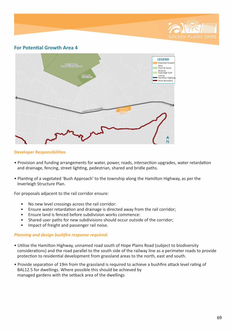
69
For Potential Growth Area 4
Developer Responsibilities
•Provisionandfundingarrangementsforwater,power,roads,intersectionupgrades,waterretardationanddrainage,fencing,streetlighting,pedestrian,sharedandbridlepaths.
•Plantingofavegetated‘BushApproach’tothetownshipalongtheHamiltonHighway,aspertheInverleighStructurePlan.
Forproposalsadjacenttotherailcorridorensure:
• Nonewlevelcrossingsacrosstherailcorridor:• Ensurewaterretardationanddrainageisdirectedawayfromtherailcorridor;• Ensurelandisfencedbeforesubdivisionworkscommence:• Shareduserpathsfornewsubdivisionsshouldoccuroutsideofthecorridor;• Impactoffreightandpassengerrailnoise.
Planning and design bushfire response required:
•UtilisetheHamiltonHighway,unnamedroadsouthofHopePlainsRoad(subjecttobiodiversity considerations)andtheroadparalleltothesouthsideoftherailwaylineasaperimeterroadstoprovideprotectiontoresidentialdevelopmentfromgrasslandareastothenorth,eastandsouth. •Provideseparationof19mfromthegrasslandisrequiredtoachieveabushfireattacklevelratingofBAL12.5fordwellings.Wherepossiblethisshouldbeachievedbymanagedgardenswiththesetbackareaofthedwellings
About this Document: This map has been created for the purpose of showing basic locality information over Golden Plains Shire Council. Cadastral information has been provided by Land Victoria and may not accurately reflect true title status and/or boundary definition.
Disclaimer: This map is a representation of the information currently held by Golden Plains Shire Council. While every effort has been made to ensure the accuracy of the product, Council accepts no responsibility for any errors or omissions.0
THE COMMON - FLORA AND FAUNA RESERVE
INVERLEIGH GOLF COURSE
HAMILTON HIGHWAY POTENTIALGROWTH AREA 4
N
LEGENDPotentialGrowthArea
HamiltonHighwayShireBoundary
Flora&FaunaReserveInverleighGolfCourse

70
8. WAY FORWARD
ToensurethereisstrongpolicyguidanceforfuturedevelopmentwithinInverleigh,thekeydeliverablesfromtheInverleighStructurePlanwillundergoaformalamendmentprocessinordertobeincludedintheLocalPolicyoftheGoldenPlainsPlanningScheme.
TheStructurePlanwillbecomeareferencedocumentoftheGoldenPlainsPlanningSchemethatwillguidetheassessmentoffutureproposalsinInverleigh,inordertomaintainthevillagecharmandrurallandscapesasthetowncontinuestogrowatamoderatepace.

71
ATTACHMENTS
Attachment A:InverleighFrameworkPlan,2019
Attachment B:InverleighStructurePlan–SettlementBoundary
Attachment C:InverleighStructurePlan–TownshipGatewaysandApproach
Attachment D:InverleighStructurePlan–ZoningandLandUse
Attachment E:InverleighStructurePlan–NeighbourhoodandCharacter
Attachment F:InverleighStructurePlan–HeritagePlan
Attachment G:InverleighStructurePlan–LandscapeandOpenSpacePlan
Attachment H:InverleighStructurePlan–DrainagePlan
Attachment I:InverleighStructurePlan–InfrastructureandServicesPlan
Attachment J:InverleighStructurePlan–MovementandAccess
Attachment K:DevelopmentFeasibilityStudy,2018
Attachment L:StrategicBushfireRiskAssessment,2018
Attachment M:CurrentprovisionsofClause11.03-6L