investigation into the contact between the maltese … of the investigation into the contact between...
TRANSCRIPT

Report No 157
Navigation (Marine Casualty) Regulations
Report of the investigation into
the contact between the Maltese flag bulk cargo vessel
Amarantos
and the wharf at
Wallaroo in South Australia
on 10 April 2000
Issued by the
Australian Transport Safety Bureau
December 2000

ISBN 0 642 20034 3
Investigations into marine casualties occurring within the Commonwealth's jurisdiction areconducted under the provisions of the Navigation (Marine Casualty) Regulations, madepursuant to subsections 425 (1) (ea) and 425 (1AAA) of the Navigation Act 1912. TheRegulations provide discretionary powers to the Inspector to investigate incidents as defined bythe Regulations. Where an investigation is undertaken, the Inspector must submit a report tothe Executive Director of the Australian Transport Safety Bureau (ATSB).
It is ATSB policy to publish such reports in full as an educational tool to increase awareness ofthe causes of marine incidents so as to improve safety at sea and enhance the protection of themarine enviroment.
To increase the value of the safety material presented in this report, readers are encouraged tocopy or reprint the material, in part or in whole, for further distribution, but shouldacknowledge the source. Additional copies of the report can be obtained from:
Inspector of Marine AccidentsAustralian Transport Safety BureauPO Box 967Civic Square 2608 ACT
Phone: 02 6274 60881800 621372
Fax: 02 6274 6699Email: [email protected] address: www.atsb.gov.au
ii

iii
Contents
Summary . . . . . . . . . . . . . . . . . . . . . . . . . . . . . . . . . . . . . . . . . . . . . . . . . . . . . . . . . . . . . . . . .1
Sources of information . . . . . . . . . . . . . . . . . . . . . . . . . . . . . . . . . . . . . . . . . . . . . . . . . . . . . .3
Acknowledgment . . . . . . . . . . . . . . . . . . . . . . . . . . . . . . . . . . . . . . . . . . . . . . . . . . . . . . . .3
Narrative . . . . . . . . . . . . . . . . . . . . . . . . . . . . . . . . . . . . . . . . . . . . . . . . . . . . . . . . . . . . . . . . .5
Amarantos . . . . . . . . . . . . . . . . . . . . . . . . . . . . . . . . . . . . . . . . . . . . . . . . . . . . . . . . . . . . .5
Wallaroo . . . . . . . . . . . . . . . . . . . . . . . . . . . . . . . . . . . . . . . . . . . . . . . . . . . . . . . . . . . . . .5
The incident . . . . . . . . . . . . . . . . . . . . . . . . . . . . . . . . . . . . . . . . . . . . . . . . . . . . . . . . . . . .6
Comment and Analysis . . . . . . . . . . . . . . . . . . . . . . . . . . . . . . . . . . . . . . . . . . . . . . . . . . . . .11
Evidence . . . . . . . . . . . . . . . . . . . . . . . . . . . . . . . . . . . . . . . . . . . . . . . . . . . . . . . . . . . . .11
Amarantos . . . . . . . . . . . . . . . . . . . . . . . . . . . . . . . . . . . . . . . . . . . . . . . . . . . . . . . . . . . .11
Other evidence . . . . . . . . . . . . . . . . . . . . . . . . . . . . . . . . . . . . . . . . . . . . . . . . . . . . . . . . .12
The pilotage . . . . . . . . . . . . . . . . . . . . . . . . . . . . . . . . . . . . . . . . . . . . . . . . . . . . . . . . . . .13
Timing of events . . . . . . . . . . . . . . . . . . . . . . . . . . . . . . . . . . . . . . . . . . . . . . . . . . . . . . .14
Ship’s speed . . . . . . . . . . . . . . . . . . . . . . . . . . . . . . . . . . . . . . . . . . . . . . . . . . . . . . . . . . .14
Ship’s impulsion and manoeuvring . . . . . . . . . . . . . . . . . . . . . . . . . . . . . . . . . . . . . . . . . .15
Simulation . . . . . . . . . . . . . . . . . . . . . . . . . . . . . . . . . . . . . . . . . . . . . . . . . . . . . . . . . . . .17
Tugs . . . . . . . . . . . . . . . . . . . . . . . . . . . . . . . . . . . . . . . . . . . . . . . . . . . . . . . . . . . . . . . . .19
Propeller efficiency . . . . . . . . . . . . . . . . . . . . . . . . . . . . . . . . . . . . . . . . . . . . . . . . . . . . .20
Pilotage organisation . . . . . . . . . . . . . . . . . . . . . . . . . . . . . . . . . . . . . . . . . . . . . . . . . . . .22
The Pilot - experience, fatigue and medical condition . . . . . . . . . . . . . . . . . . . . . . . . . . . .22
Ship size Wallaroo . . . . . . . . . . . . . . . . . . . . . . . . . . . . . . . . . . . . . . . . . . . . . . . . . . . . . .22
Procedures . . . . . . . . . . . . . . . . . . . . . . . . . . . . . . . . . . . . . . . . . . . . . . . . . . . . . . . . . . . .24
Bridge organisation . . . . . . . . . . . . . . . . . . . . . . . . . . . . . . . . . . . . . . . . . . . . . . . . . . . . .25
Conclusions . . . . . . . . . . . . . . . . . . . . . . . . . . . . . . . . . . . . . . . . . . . . . . . . . . . . . . . . . . . . . .27
Submissions . . . . . . . . . . . . . . . . . . . . . . . . . . . . . . . . . . . . . . . . . . . . . . . . . . . . . . . . . . . . . .29
Details of ship . . . . . . . . . . . . . . . . . . . . . . . . . . . . . . . . . . . . . . . . . . . . . . . . . . . . . . . . . . . .33
Figures
1. Amarantos . . . . . . . . . . . . . . . . . . . . . . . . . . . . . . . . . . . . . . . . . . . . . . . . . . . . . . . . . . . . .iv
2. Port of Wallaroo and Amarantos’s approximate track . . . . . . . . . . . . . . . . . . . . . . . . . . . . .4
3. Wallaroo jetty and grain loader damage . . . . . . . . . . . . . . . . . . . . . . . . . . . . . . . . . . . . . .10
4. Pilot’s perspective from port bridge wing . . . . . . . . . . . . . . . . . . . . . . . . . . . . . . . . . . . . .17
5. Propeller immersion . . . . . . . . . . . . . . . . . . . . . . . . . . . . . . . . . . . . . . . . . . . . . . . . . . . . .21
6. Amarantos events and causal factor chart . . . . . . . . . . . . . . . . . . . . . . . . . . . . . . . . . . . . .30
iii

iv
FIG
UR
E 1
Am
aran
tos

SummaryOn the morning of 10 April 2000 the 64 957tonne, Maltese flag, panamax bulk carrierAmarantos was inbound to the port ofWallaroo at the eastern side of the SpencerGulf, South Australia. The vessel was inballast and intending to load 20 000 tonnesof wheat for export to Iraq.
The main engine was prepared for thearrival stand-by and tested astern at 0510;the chief engineer was conducting enginemanoeuvring from the control room.
A Ports Corp South Australia pilot boardedthe vessel outside the Wallaroo entrancechannel. At 0612, after the pilot had madehis way to the bridge, a pilot/masterinformation exchange took place. The pilottook charge of the navigation and broughtthe ship on to an easterly heading to enterthe port south of the shipping channel.
At 0645, Amarantos was met by the twoharbour tugs, Kalanbi and Ungarra, south ofthe number 11 channel beacons. Kalanbi,the marginally smaller of the two tugs was‘made fast’ to the ship’s bow and Ungarra tothe stern.
Amarantos continued a ‘normal’ approach tothe Wallaroo jetty and, at 0708, the master
of the vessel noted the ship’s speed at 3 knots ahead with the ship approximately500 m north-east of the berth. The pilot wasturning the ship, at this time, onto asoutherly heading to approach the berthnearly at right angles. Off the berth heintended using the tugs and the effect of thetransverse thrust of the propeller with theengine going astern, to berth ‘port-side-to’.
Despite putting the engine astern and thetugs attempting to turn Amarantos, the shipmaintained a nearly steady course. Initiallythis did not concern the pilot, but with thebow 30 m from the wharf, he ordered allpersonnel to be cleared from the jetty, ascontact seemed inevitable.
At a time logged by the ship’s crew as 0720,Amarantos made contact with the Wallaroojetty causing substantial damage to the jettydeck timbers, piles, and the grain loader andits supporting superstructure mounted on thejetty. The vessel struck the jetty almost atright angles and continued on into the jettyfor a distance of 3.5–4 m. The shipsustained only minor non-structural damagein the incident.
Amarantos moved clear of the jettyimmediately after the contact, and wassubsequently berthed by the pilot alongsidethe number 2 north berth with all linesashore at 0820.
1

2

3
Sources ofinformationThe master and crew of Amarantos
The pilot
The master of the tug Kalanbi
The master of the tug Ungarra
The Wallaroo wharf supervisor
Ports Corp South Australia
The Australian Maritime College
The Australian Maritime Safety Authority
Transport South Australia
Bureau of Meteorology
Dr Jeff Brock, Consultant Adviser AviationMedicine, Director General Defence HealthService
Dr Stan Gottschalk, Australian MaritimeCollege
Wartsila NSD, Sydney
AcknowledgmentCover photograph of Amarantos supplied bythe Advertiser newspaper, Adelaide
The investigation was conducted with thehelp of, and on behalf of, Malta MaritimeAuthority, under the provisions of IMOresolution A.849(20), ‘Code for theInvestigation of Marine Casualties andIncidents’.
The Australian Transport Safety Bureau isgrateful for the assistance provided by thestaff at the Australian Maritime College’sship simulator unit which was used toreconstructed the incident in the analysis.

4
0612
xx 06
36x
x06
4506
54
0703
x x
0708
x x
0717
0720
Amar
anto
s’s
appr
oxim
ate
track
Qld
WA
SA
Vic
Lo
cati
on
of
inci
den
t
NS
W
AC
T
Tas
NT
FIG
UR
E 2
Po
rt o
f Wal
laro
o &
Am
aran
tos’
s ap
pro
xim
ate
trac
k

Narrative
AmarantosAmarantos (fig. 1) is a Maltese flagpanamax bulk carrier of 64 957 deadweighttonnes at its summer draught of 13.3285 m.The vessel is owned by Amarantos ShippingCo. Ltd of Valletta, Malta, and the registeredagents are Dileship Marine Corporation ofPiraeus, Greece. It is classed with Lloyd’sRegister as a 100A1 bulk carrierstrengthened for heavy cargoes, with
LMC1 and UMS2 notations.
Amarantos was built in 1980 by MitsubishiHeavy Industries Ltd in Kobe, Japan. Theship has an overall length of 224.00 m, amoulded breadth of 31.80 m and a mouldeddepth of 18.35 m. The vessel is powered bya 6-cylinder Sulzer 6RND76M single acting,direct reversing, 2-stroke diesel engine, of10 592 kW. The main engine drives a singlefixed-pitch right hand propeller giving aservice speed of 14.75 knots.
The vessel is of standard bulk carrier designwith seven cargo holds that are locatedforward of the accommodationsuperstructure. Amarantos’s bow-to-bridgedistance is 182.80 m. The top of theforecastle bulwark overhangs the mostforward part of the bulbous bow by approxi-mately 4.8 m. The top of the forecastlebulwark is 23.3 m above the keel.
Amarantos has a crew of 23, with a masterand three mates, chief and four engineers,boatswain and six deck ratings, three engineroom ratings and four catering staff. The
mates maintain a traditional ‘4 on, 8 off’,watchkeeping routine.
At the time of the incident, the master ofAmarantos held a Greek Master Class 1certificate of competency and had 26 yearsexperience as master. He had been on thevessel for a total of 15 months including theprevious 5 months on the current crew‘swing’.
The Ports Corp South Australia pilot onboard Amarantos at the time of the incidentheld pilot’s licences for the South Australianports of Wallaroo, Port Pirie, Port Giles,Thevenard, Port Lincoln, and Adelaide. Hehad 31 years experience as a marine pilotand had served as harbour master atWallaroo for 2 years, from 1976 to 1978.
Wallaroo Wallaroo is located on the eastern side ofthe Spencer Gulf on the Yorke Peninsulaapproximately 80 miles3 north-west ofAdelaide (fig. 2). The port of Wallaroo’smain function is to service the wheatfarming industry in the local area byhandling the export of grain and the importof farming phosphates. The shippingfacilities in the port consist mainly of a jettyand a grain loader, with its associatedconveyors and storage silos.
The Wallaroo jetty is owned by Ports CorpSouth Australia and was built in 1957/58. Itis 867 m in length and has three ship berthson each side numbered 1, 2 and 3 north andsouth. The jetty runs west-north-west fromthe shore into Wallaroo Bay. A grainconveyor and ship loader, owned by SouthAustralian Co-operative Bulk Handling,forms a superstructure on much of the jetty
5
1 Notation assigned when machinery is constructed and installed under Lloyd’s Special Survey in accordance with Lloyd’s rules.
2 Notation denotes ship may be operated with the machinery spaces unattended.3 Miles referred as Nautical miles = 1 852 metres.

and extends to a point 195 m from jettyhead. The grain conveyor takes grain fromsilos on the shore to the south of the jetty, tothe grain loader located adjacent to thenumber 2 north berth.
The gain loader consists of an elevated mainconveyor house and five slewing loadingbooms. The main conveyor house ismounted on a steel superstructure 11.5 mabove the jetty and the loading booms arespaced at 22 m intervals along the mainconveyor house. Grain is fed out from themain conveyor belt into the slewing loadingbooms, and then into the ship’s holds. Eachboom conveyor has an enclosed controlposition adjacent to main conveyor houseand a central control station is located ontop of the main conveyor house on the spanbetween the third and fourth loading booms.When not in use, the loading booms are‘stowed’ alongside the main conveyor house.
The port of Wallaroo has a shipping channelapproximately 6 790 m long which ismarked by beacons. The channel runs froma 300 m swinging basin north-west of thejetty head in a north-south direction west ofnumber 12 beacon for a distance of about 1 500 m. It then turns to an alignment of267°/087° at number 6 beacon through anarc of 1 400 m with a radius of turn of about1 100 m. The distance from the number 6beacon to the channel entrance beacon isabout 3 890 m (2.1 miles). The channel andswinging basin, centred, have a depth of 8.5 m below datum. The depth of water atnumber 2 north berth is 9.5 m.
Pilotage is compulsory for the port ofWallaroo.
Vessels in ballast generally enter the portsouth of the channel and approach the jettyfrom east of the channel across the ‘flats’.Those vessels berthing on the north side of
the jetty secure the tug or tugs near number11 beacon and turn in an arc to approach thejetty almost at right angles for the last200–400 m. This approach crosses the 8 mdepth contour into depths marginally below8 m between 400 m and 250 m off the berth.
The conventional twin-screw tug Kalanbi ispermanently stationed at Wallaroo. Kalanbihas a nominal bollard pull of 11.5 tonnes.The master of Kalanbi, at the time of theincident, had 20 years experience as a tugmaster and had a long and intimateknowledge of the port.
When berthing ‘handy size’ bulk carriers ofless than 200 m in length, Kalanbi is used asthe sole tug, often in conjunction with theship’s anchor. For panamax size vessels of220 m and over, or vessels with a beamgreater than 30 m, two tugs are used. Anadditional tug is sent from another port. Thetug, which is usually used in Wallaroo, if anextra tug is required, is Ungarra from PortPirie. Ungarra has a nominal bollard pull of13 tonnes and is also a conventional twin-screw tug. The master on Ungarra, at thetime of the incident, had 27 yearsexperience on tugs, 17 years as master.
Ports Corp South Australia have standardoperating procedures for all ships whichdetail a minimum number of essentialpersonnel being present on the wharf duringberthing operations.
The incident
19 March - 0600 10 April
Amarantos departed Nantong, China, on 19 March 2000, after 3 weeks in a shiprepair yard including 6 days in dry dock.The vessel was bound for Wallaroo in SouthAustralia to load a part cargo of 20 000 tonnesof wheat for export to Iraq. The voyagesouth had been uneventful and Amarantosarrived at the anchorage off Port Wallaroo in
6

the evening of 6 April. Amarantos was dueto berth on the morning of 10 April.
In the late afternoon of 9 April, the pilotrostered to berth Amarantos left his home inAdelaide to travel to Wallaroo. He arrived athis motel, a few minutes from the Wallaroojetty, in the early evening. He had a mealand then went to bed at about 2130.
At 2300 on 9 April, the tug Ungarra sailedfrom Port Pirie. Ungarra was to assist theWallaroo-based tug Kalanbi with theberthing of Amarantos.
Amarantos remained at the anchorage until0500 on 10 April. It then weighed anchorand proceeded to the pilot boarding ground.The main engine was tested astern at 0510.Main engine manoeuvring was beingeffected from the control room console asthe chief engineer felt that this practice wasmore economical on starting air than usingthe automated bridge control system. Twosteering pumps were in operation inpreparation for the pilotage.
The pilot rose at 0445 and boarded the pilotlaunch at 0530. The launch then proceededout to the pilot boarding ground to meetAmarantos. The crew of Kalanbi preparedthe tug for the berthing operation andrendezvoused with Ungarra, which hadarrived off the jetty, at about 0500.
At 0540, Amarantos was on an easterlycourse in a position north-west of theWallaroo shipping channel entrance beaconsand slowing down to take the pilot. Therewas a small choppy sea running and a north-easterly breeze, which was estimated at 5knots. The pilot ladder was rigged on theport side. After the pilot launch camealongside the launch coxswain realised theship would need to turn hard to port tocreate a ‘lee’ for the pilot to board.
10 April 0612 to 0820
A lee was made on a northerly heading andthe pilot finally embarked. The pilot arrivedon the bridge at about 0612 and afterbringing the vessel around to complete theturn towards the entrance beacons, heordered ‘full ahead’ and altered course tobring the ship south of the entrance channel.A master/pilot information exchange tookplace. The pilot described his plannedpassage to the berth including the courses tobe followed and the proposed disposition ofthe tugs. The plan was to berth the vesselport-side-to the number 2 north berthalongside the grain loader at the Wallaroojetty.
The master indicated to the pilot that themain engine was ready for manoeuvring andthat the ship’s crew had prepared an anchorfor ‘letting go’. By this time the first matewas stationed on the forecastle. The masterstated that at this time the pilot was handeda pilot information card. The master did notindicate to the pilot that the main enginewas being manoeuvred from the controlroom.
The pilot kept Amarantos on an easterlycourse parallel and to the south of theshipping channel, at ‘full ahead’, until 0625.He then ordered ‘half ahead’, then ‘slowahead’ at 0627, ‘dead slow ahead’ at 0632and finally ‘engine stop’ at 0636. The vesselwas passing south of number 7 channelbeacon at this time.
At about 0645, Amarantos met the tugsUngarra and Kalanbi as the ship passedsouth of number 11 beacon. The tugsobserved the ship approaching slowly.Kalanbi, the forward tug, allowed the ship tooverhaul it and then took a mooring ropefrom Amarantos’s centre bow lead toconnect the tow to its main deck towing
7

hook. Ungarra took a line from the centrelead at the stern of the ship and connectedthe tow to its main towing hook. Both ropessupplied by the ship were in good conditionand did not inhibit the operation of the tugs.
At about the time the tugs were made fast tothe vessel, the mooring gang arrived at thejetty. The wharf supervisor (wharfinger),who had been in a hut on the jetty since0530, came out and organised the forwardand aft mooring crews. The mooring crewsstood by as the ship manoeuvred off theberth with the wharfinger ready to call thedistance to the berth for the pilot. Thewharfinger stood at an angle to theapproaching ship to allow him a betterperspective.
At 0654, the pilot ordered ‘dead slow ahead’and then ‘engine stop’ at 0703. About thistime the pilot ordered starboard helm to startswinging the ship towards the berth. Theship was now approximately 1200 m north-east of the berth.
As the ship turned towards the berth,Kalanbi ran ahead with just enough weighton the rope to keep it clear of the water.Ungarra ran parallel to the ship’s portquarter, again with the tow rope clear of thewater.
At 0708 the pilot again ordered ‘dead slowahead’. The master stated that he had seenthe vessel’s speed indicated on the globalpositioning system (GPS) on the bridge as 3 knots ahead at this time. The vesselcontinued to swing and by this time was ona southerly heading and approaching thejetty almost at right angles.
The pilot ordered ‘engine stop’ at 0710, andthe ship continued to drift in to the berth.The ship’s movement book and the masterindicated that the pilot also ordered ‘deadslow astern’ at 0710, however, the pilot was
adamant that he did not order ‘dead slowastern’ at this time.
At 0715 the pilot ordered ‘slow astern’. Hefelt the approach to the berth was goingnormally at this stage. The wharfinger wasreporting the estimated distance betweenAmarantos’s stem and the jetty by VHFradio and, at this time, he indicated to thepilot that the ship was 200 m off the berth.The pilot was on the port bridge wing,looking at the main engine tachometer. Thepilot’s recollection was that when he rang‘slow astern’ (at about 0715) he noticed thatthe main engine did not start astern for aperiod he estimated at 15-20 seconds. Hecalled ‘no engines’ to the officer in thewheelhouse and ordered ‘half astern’. Thepilot then saw the tachometer move toindicate that the main engine had startedastern. The crew noted the time of thisengine movement as 0717. After he had seenthe engine start astern, the pilot still felt thatthe berthing would proceed to a satisfactoryconclusion.
When the vessel was 150 m off, and still atright angles to the berth, the pilot realisedthat the ‘half astern’ movement was havinglittle effect on the ship’s speed. He ordered‘full astern’ and also full power on both tugsto swing the ship. The ship’s staff logged thetime at 0718.
The tugmaster on Kalanbi applied fullpower at the pilot’s command with the tug atright angles to the starboard bow by thistime. Ungarra was forward of the ship’s portquarter and the tugmaster also applied fullpower and rudder to bring his tug around tobe 90° to the ship’s stern.
Amarantos’s mate, stationed on theforecastle head, was also keeping contactwith the master by UHF radio, reporting theship’s distance from the jetty. The masterstated that he passed this information on to
8

the pilot on at least two occasions but thepilot did not recall any distances beingrelayed by the master at this time.
The ship continued to close on the jetty,with the combined power of the tugs makinglittle progress in swinging the vessel. Thepilot considered dropping an anchor at thisstage but felt that it was too late to have anyappreciable effect. With the ship now 70 mfrom the jetty, the master took the initiativeand rang the chief engineer to order‘emergency full astern’ revolutions.
The chief engineer promptly operated themain engine ‘load program bypass’ switchand increased the speed setting lever. Themain engine was quickly brought to 105 rpm astern with the ship about 30 m offthe jetty. The pilot glanced at the mainengine tachometer at this time and notedthat it was in the ‘3 o’clock’ position(approximately 105 rpm astern). Thewharfinger continued counting down thedistance as the ship closed the jetty andwhen he told the pilot ‘you are going to hit’,the pilot told him to ‘clear the jetty’.
At a time recorded as 0720 by the ship’screw, Amarantos made contact with theWallaroo jetty and grain loader. The jettyand the grain loader superstructure weredamaged substantially by the impact.
With the main engine still running at 105 rpm astern, Amarantos started to moveastern almost immediately after the contact.The pilot remained calm and ordered main‘engine stop’ at 0721. The two tugscontinued to swing the ship alongside thejetty and after a ‘dead slow astern’movement at 0724 and ‘engine stop’ at0726, the pilot boat ran the first mooringline at 0728. The pilot continued to berth theship and, after several more brief enginemovements, Amarantos was alongside thenumber 2 and 3 north berths with the tugsbeing let go at 0800 and mooring completedat 0820.
When he was leaving the bridge, the pilotasked the master to sign the usual PortsCorp pilotage certificate; this request wasfollowed by some discussion between themaster and pilot regarding the cause of theincident. The master wrote a comment onthe bottom of the pilotage certificate:
Due to bad operation manoeuvring of thepilot.…the vessel touched the loading wharf andcaused damage to the elevator and wharf.
The pilot stated that when he was leavingthe ship, the second mate approached himand asked him to sign the pilot card. He saidthat this was the first time that he had seenthis document.
9

10
FIGURE 3Wallaroo jetty and grain loader damage

11
Comment andanalysis
Evidence
Site examination
Amarantos made contact with the jetty about291 m from its western end, between pylons2 and 3 supporting the grain loader mainconveyor house (fig. 3). Contact was at apoint where there were no fenders to protectthe berth. Either side of the point of impact,there are substantial horizontal fenders. Theangle of contact was 90° or within 15° ofthe perpendicular on a heading between195° and 210°.
First contact appeared to have been madebetween the bulwark at the stem of the shipand the number 2 grain loading boom,which was housed alongside the second lastspan of the main conveyor house. Thiscontact was followed almost simultaneouslyby the ship’s bulbous bow on the landtie anddecking timbers of the jetty itself. AsAmarantos’s forward momentum continued,the loading boom was forced into the mainconveyor house, resulting in a 2–3 m lateraldeformation of the house and its supportingsteel superstructure. The bulbous bow alsocontinued to travel into the wooden jetty,breaking up the deck timbers for a distanceof 3.5–4 m.
Despite significant damage to the jetty andgrain elevator, Amarantos was found to havesustained only minor damage. There wasscratched paint around the stem at, and justbelow, forecastle head level (about 18 m abovethe water line) and on the upper part of thebulbous bow, between the 8.4 m and 9.2 mdraught marks (4–5 m above the waterline).The handrail at the top forecastle bulwark
was also damaged with one end left lying onthe forecastle deck.
The ship’s arrival draughts were stated to be4.25 m forward and 6.7 m aft giving adisplacement of 29,850 tonnes. The eyewit-nesses indicated that the ship seemed to stopand gain sternway almost immediately afterthe impact. This is consistent with the factthat those on the bridge or in the engineroom felt no impact, and there was arelatively small degree of penetration of thejetty, given the displacement of the vessel.
AmarantosThe evidence relating to the incident isalmost entirely based on the subjectiveaccounts of eyewitnesses. There is a lack ofdirect objective evidence and reliabledocumentation to substantiate the evidencegiven at interview by the pilot, master, firstmate, second mate, chief engineer andhelmsman.
Amarantos was equipped with a courserecorder. This was operational, but had notbeen switched on since leaving Nantong andwas not running on arrival Wallaroo. Theengine control room was also equipped withan alarm logger, but this had not beenoperational for some time and was notrepaired at the refit in Nantong. If available,the alarm logger may have provided corrob-orative evidence based on the record of anyalarm condition during the incident. Theship was not equipped with an automaticengine movement recorder.
Engine movements were recorded manuallyboth on the bridge and in the engine room inpurpose-printed ‘bell books’, movementtimes being recorded to the nearest minuterather than half minute or less. The bridgeclock was checked against the engine roomclock by the investigators. The two clockswere within 6 seconds of each other at thetime they were checked.
There was inconsistency in the way enginemovements were recorded in the bridge bellbook from port to port. Examination of both‘bell books’ showed a lack of consistency inthe way the movements were recorded overa number of passages under pilotage. Someentries were overwritten including sometimes recorded during the passage intoWallaroo.
Comparing the two bell books between 0500and 0730 on 10 April, there is a significantmismatch of times up to 0654, after whichthe times largely coincide. No time ofimpact was recorded by the engine room, asnone was felt. The time of impact in thebridge movement book appears to have beeninserted at some time after 0721, putting indoubt this ship’s record. In the engine roombell book the ‘dead slow astern’ movementat 0710 was written on the same line as the‘slow astern’ movement whereas generally,though not exclusively, each movement timewas recorded on a separate line.
Further, the bridge ‘bell book’ did notrecord the time of passing the channelbeacons, nor were these marked on theship’s chart of the port approaches(Admiralty chart Aus 777 inset of portWallaroo on a scale of 1:35000). Thus, itwas not possible to check engine movementsagainst positions and arrive at someindependent assessment of the ship’s speedat various critical times.
The inspector cannot rely on the bridge bellbook as an accurate and contemporaneousrecord of the ship’s movements.
After interviewing the chief engineer andpilot, investigators performed a test on themain engine to establish the time required tostart the main engine astern after aheadrunning. After the usual systempreparations, ‘control room control’ wasselected on the manoeuvring console in the
engine control room. The engine telegraphin the control room was then moved from‘slow ahead’ to ‘stop’ and then ‘slowastern’. This process was repeated severaltimes with the engine being ‘ready’ forstarting astern each time after a delay of 4–5 seconds. This type of main engineutilises a ‘lost motion’ camshaft system toachieve astern running. The 4–5 secondsdelay is the time required for the camshaftto be rotated into the astern running positionusing engine oil pressure.
Following the incident all the personnel onthe bridge were subject to a test by analcohol breathalyser by the South AustralianPolice Service. All those tested returned a‘nil’ reading.
Other evidence Other eyewitnesses including the wharfsupervisor, the tug masters and the pilotlaunch coxswain provided accounts of theincident. Once again, there is no objectivesource of data. The investigation relies uponthe limited times noted by the individualsinvolved.
No relevant times were recorded except thetime the tugs took the ship’s rope and that ofthe impact.
There is no weather observing station atWallaroo. The Bureau of Meteorologyestimated the wind direction and speed asbetween 060° and 090° at 5 knots. Thisestimation was based on observations for0600–0730 at Maitland and Kadina andanalysis of the synoptic weather, includinglow level; atmospheric wind and stabilityinformation. The estimation is alsoconsistent with the wind estimated by thewharf supervisor and the tug masters.
Given the absence of objective data much ofthe analysis is based on the time of 0717
12

when the ship was estimated by thewharfinger to be 200 m from the jetty. Insubmission the pilot questioned the accuracyof the distance. The wharfinger stated thathe stood at an angle to the ship’s approach,rather than end on, to obtain a betterperspective of distance. The wharfinger wasa man of considerable experience and giventhe ship itself was 224 m in length theinspector accepts that the wharfinger’sestimation of the distance was accuratewithin reasonable limits.
After considering the conflicting evidenceavailable to the investigation, it was decidedto recreate the incident on the AustralianMaritime College’s ship simulator. The aimof the simulation was to resolve someanomalies in the various accounts of theincident and to attempt to derive someindependent, objective data.
Figure 6 shows the sequence of events andsome factors involved in the incident.
The pilotage
Planned passage
When the pilot arrived on Aramantos’sbridge at 0612, the pilot showed the mastera folder containing his ‘pro forma’ passageplan for berthing at Wallaroo. This was inaccordance with the operating proceduresdetailed in the Ports Corp South Australia‘Pilotage Port Adelaide Procedures’.
The inward passage takes a ship about 500 m south, and parallel to, the channelbeacons from the Entrance Beacon, tonumber 7 beacon, on an easterly course.Ships take any tug(s) required, in the areasouth of number 11 beacon. A ship is thenturned on a southerly course and makes anapproach to the berth, either nearly at rightangles or at a more oblique angle. This
approach over the port Wallaroo ‘Flats’ is astandard passage and is prescribed in thePorts Corp South Australia document,Pilotage Port Adelaide Procedures, forvessels exceeding the port limits of 200 min overall length or 30 m beam. The pilotageprocedures also require that a minimumunder keel clearance of 0.9 m or 10 per centof draught be maintained, based on aminimum depth of 7.7 m below datum.
On 10 April, the pilot followed this standardprocedure, choosing to approach the berth atright angles and relying on the transversethrust generated by the right hand propellerturning astern to turn the vessel parallel tothe berth. The tugs were to augment andcontrol the transverse thrust of the propeller.As the tug power was limited, there was aneed to complete the turn as close to thejetty as possible, dictated by the windage ofthe ship which would make pushing the shipagainst, or holding the ship off the jetty inany wind, difficult.
The pilot’s estimation of the wind wasnorth-easterly at 10 knots and the windageof the vessel in ballast meant he consciouslytook a route closer to the shore, using the‘finger jetty’ at the eastern end of the mainjetty as a guide. This approach was onlymarginally to the east of the standardapproach. It did mean, however, that theship would have been in water depths of 7.7 m, and 7.3 m below datum as itapproached between 500 m and 200 m fromthe jetty. The predicted tidal height of 0.6 m, gave Amarantos a minimum underkeel clearance of 1.2 m, 0.5 m more than theminimum stipulated in the pilotageprocedures.
The tidal range at Wallaroo on the morningof 10 April was 0.1 m. The port experiencesminimal tidal flow and on 10 April there
13

would have been no tidal effect influencingthe behaviour of the ship.
Timing of eventsIn the absence of reliable records, thefollowing analysis is based on the times ofthree events that were probably accurate towithin one minute:
• 0634 (passing number 7 beacon) This isbased on the pilot’s statement that heroutinely stopped a ship’s engine andallowed the way to carry the ship tonumber 11 beacon to secure any tugs.
• 0717 (the pilot’s order for ‘half astern’)The wharfinger and tug skippers statedthey heard this on the VHF. Thiscoincides with the time the wharfingertold the pilot the ship’s bow was 200 moff the jetty.
• 0720 (the most likely time of impact).This was stated by the wharfinger andship’s staff, and is consistent with theprobable speed of the ship.
Ship’s speedEvidence as to speed and time is critical tothe analysis of this incident.
At 0654, the pilot put the engine to ‘deadslow ahead’ for about 8 minutes. ‘Dead slowahead’ revolutions (35 rpm) give atheoretical speed of 4.5 knots. However, theship was turning towards the berth andwould not have attained this speed in thetime. Some forward moment would havebeen generated. The engine was thenstopped at 0703 for 5 minutes before afurther 2 minutes at ‘dead slow ahead’, at0708.
The master stated that he had noticed on theGPS that the ship was making 3 knotsheadway at 0708. The pilot estimated the
speed at just over 1 knot a couple of minutespast 0710. Neither of these statements canbe accurately verified, however the pilot’sestimation of 1 knot is inconsistent with thedistance the ship had to travel to the jetty,and the times recorded for the subsequentevents. The master’s recollection of the GPSreadout at 3 knots at 0708 seems far morereasonable considering the times supplied byother witnesses for the subsequent events.At the time of the incident globalpositioning ‘selective availability’4 meantthat the GPS speed would probably havebeen accurate to ±0.3 knot.
It is probable that, at about 400 m from thejetty, the ship was making good a speed ofbetween 2.5 knots (77 m/min) and 3 knots(92 m/min). This estimate is based on theapproximate times on which this analysis ispredicated; securing the tugs and the enginemovements ordered between 0654 and 0710.
There are significant inconsistencies in thestatements regarding Amarantos’s speedimmediately before to the impact. The lackof damage to the ship, the fact that noimpact/deceleration was felt on board andthe eyewitness account that the ship seemedto go astern almost as soon as it contactedthe jetty, all indicate a low impact speed.However, the evidence is that the shippenetrated the jetty for a distance of 3–4 m.At one knot (0.514 m/sec) it would havetaken Amarantos six to eight seconds totravel the 3–4 m before coming astern. Atimpact speeds of half a knot or less, the timebetween the initial impact and comingastern would be over 15 seconds.
The inspector concludes that the ship wasmaking more headway than the pilot thoughtwhen 200 m from the jetty. This speed wasless than 3 knots (92 m/min) but more than2 knots (61 m/min).
14
4 Before 1 May 2000 the signal GPS satellites was degraded for non-US military use.
Considering the damaged sustained by thejetty and grain loader structures, the ship’sspeed at impact, was probably in the orderof 0.5 of a knot.
Ship’s impulsion andmanoeuvringThe engine was stopped at 0710 after whichtime no ahead movement was ordered untilcompleting the berthing of the ship after theimpact at 0720.
There is a significant conflict in theevidence regarding the next engine order. At0710, according to the ship’s bell books, theengine was put to ‘dead slow astern’(35 rpm) and ran at this setting until ‘slowahead’ (45 rpm) was rung at 0715. The pilotwas adamant that no astern movement wasordered until 0715, when he ordered ‘slowastern’. Despite the 0710 ‘dead slow astern’entry in the engine room bell book, the chiefengineer also expressed some uncertaintyabout the timing of the first asternmovement.
When the engine was first put astern therewas a delay of 15 to 20 seconds in theengine response. The second mate, the chiefengineer and pilot, confirmed the extent ofthis delay in separate interviews. Theevidence would indicate that this delayoccurred at 0715 when the pilot ordered‘slow astern’.
If the bell books are correct, and there was a‘dead slow astern’ movement at 0710, it isnot logical that the delay in response wouldhave occurred at about 0715. The enginewould have been already running astern forat least three minutes, probably longerdepending on the accuracy of the manualrecording. It also seems improbable that theship would have maintained sufficient way
to impact the jetty if the engine was runningat ‘dead slow astern’ for 5 to 7 minutesbefore 0717, when the bow was reported asbeing 200 m from the jetty. Afterconsidering the evidence, the most logicalconclusion is that the first astern movementwas in fact ‘slow astern’ at 0715 and theengine starting delay occurred at this time.
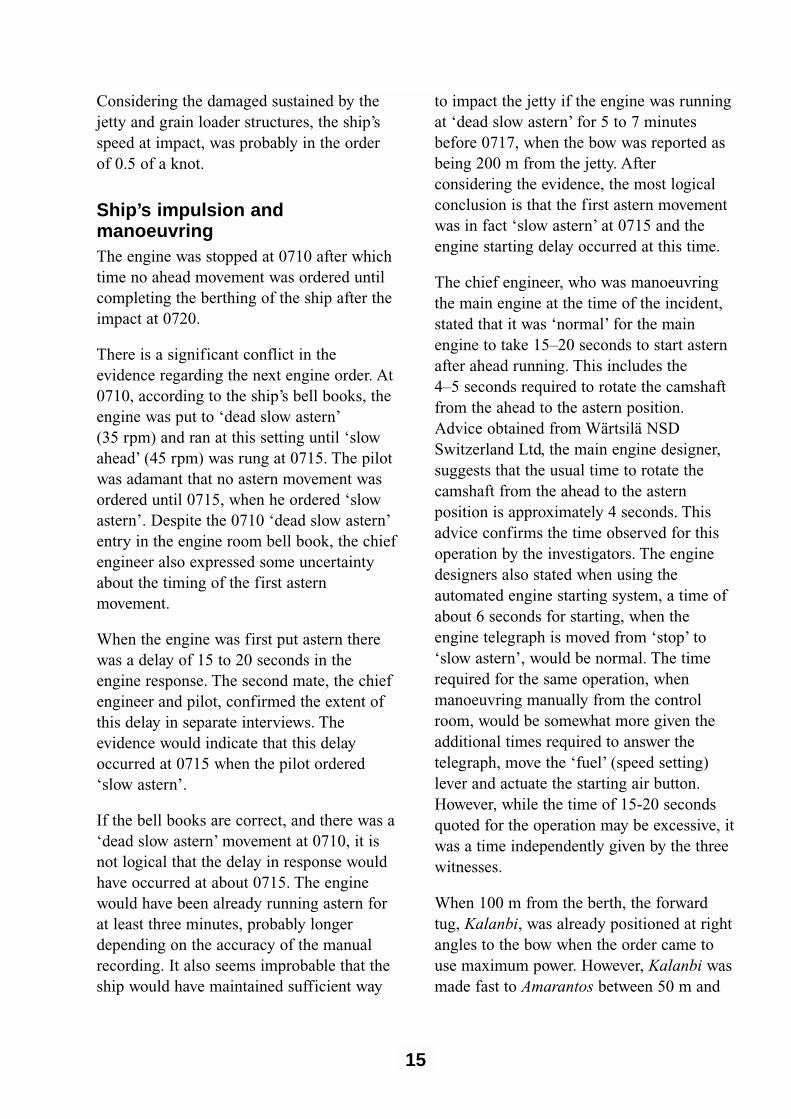
The chief engineer, who was manoeuvringthe main engine at the time of the incident,stated that it was ‘normal’ for the mainengine to take 15–20 seconds to start asternafter ahead running. This includes the 4–5 seconds required to rotate the camshaftfrom the ahead to the astern position.Advice obtained from Wärtsilä NSDSwitzerland Ltd, the main engine designer,suggests that the usual time to rotate thecamshaft from the ahead to the asternposition is approximately 4 seconds. Thisadvice confirms the time observed for thisoperation by the investigators. The enginedesigners also stated when using theautomated engine starting system, a time ofabout 6 seconds for starting, when theengine telegraph is moved from ‘stop’ to‘slow astern’, would be normal. The timerequired for the same operation, whenmanoeuvring manually from the controlroom, would be somewhat more given theadditional times required to answer thetelegraph, move the ‘fuel’ (speed setting)lever and actuate the starting air button.However, while the time of 15-20 secondsquoted for the operation may be excessive, itwas a time independently given by the threewitnesses.
When 100 m from the berth, the forwardtug, Kalanbi, was already positioned at rightangles to the bow when the order came touse maximum power. However, Kalanbi wasmade fast to Amarantos between 50 m and
15

16
60 m forward of the theoretical ‘pivotpoint’5 and would have exerted limitedturning power, even at its full nominalbollard pull of 11 tonnes.
The stern tug, Ungarra, with a nominalbollard pull of 13 tonnes, was steamingparallel to the ship at about 45° forward ofthe quarter. When the order came to pull thestern to port, the tug increased power andthen manoeuvred towards the perpendicular,a standard response. This manoeuvre wouldhave taken some seconds, possibly up to 30 seconds to complete.
The initial force exerted by the stern tugwould have tended to maintain the ship’sheadway. The forward propulsion forceexerted by the tug would have decreased asthe tug manoeuvred towards the perpen-dicular. Being a conventional tug, the tugmaster had to be conscious of the risk ofcapsize or ‘girthing’.6
Both the pilot and the master described howthe ship seemed to ‘slide’ maintaining asteady course despite the fact that there werethree turning forces acting on the ship. Thetwo tugs and the transverse thrust of thepropeller theoretically should havecombined to turn the ship to starboard, whilethe light north-easterly breeze, if it had anyeffect, would have tended to turn the ship toport with minimal effect. Whatever delay, ifany, in the initial engine astern movement,the propeller was seen to be turning asternwhen the bow was about 200 m from thejetty, just under one ship’s length. It is asthough the net effect of the propeller was tooffset the limited tug power and in fact turnthe ship’s bow to port. Rowe (1996) notesthat when the engine is put astern in shallow
water the effect of transverse thrust may beunpredictable and the bow may swing thewrong way. This is due to the dynamics ofthe water being deflected by the propelleroff the seabed.7
The pilot, however, was not concerned thatthe manoeuvre was not immediately goingas anticipated and did not consider itnecessary, either to drop the starboardanchor or to apply full starboard rudder andkicking the engine ahead to start thestarboard turn. He could also have orderedUngarra to move astern and pull. At thistime, 150 m to 100 m from the jetty,Amarantos was probably not travelling morethan two knots. The manoeuvre would havebeen possible for the experienced tugmaster, although it would have taken afurther 30 seconds or so to drive the tug intothis position.
The pilot stated that after he had seen theengine start astern he still felt that theberthing would proceed to a satisfactoryconclusion. He did not become concerneduntil the bow was about 70 m from the jetty.He did not order ‘full astern’ until approxi-mately 0718 and the master, on his owninitiative, ordered ‘emergency full astern’after this.
When asked to explain the incident, hecould only attribute the accident to a delayin the initial engine astern movement ofabout 15-20 seconds.
It is not unknown for an engine to fail tostart on the first attempt when put asternand thus delay the required manoeuvre. It isreasonable to expect that a pilot would
5 Pivot point is that point in the ship’s length will pivot when under a turning force. A ship not making way will pivot at its mid length. When making headway the pivot point is about 25 per cent of the length from the bow. When making stern way the pivot point is about 25 per cent of the ship’s length from the stern.
6 Also known as ‘girding’ and ‘girting’.7 Rowe, R.W., The Shiphandler’s Guide, The Nautical Institute, London, 1996, pg.26.

factor such an eventuality into his plan andallow for an appropriate approach speed.
Manoeuvring a ship in confined waterspresents specific problems. Manoeuvringand controlling ships involve what might beconsidered ‘delayed’ systems.
The control of ships does pose a verypeculiar set of problems. The ship is a ‘slowsystem’ in which feed-back is not availablein a direct and immediate form due to theenormous inertia of the vessel and the fluidnature of its physical environment. Thenavigator must thus take action in antici-pation of what the situation will be at sometime in the future.8
Analysing this incident involves estimatingthe ship’s speed at any particular time. Theship’s log was not operating, although the
GPS was (within the limits of selectiveavailability). The ship was over a mile offthe shore which had few if any marks orbeacons to give some estimation of the rateof closing with the jetty. Amarantos wasapproaching the berth at right angles, givingthe pilot no perspective from which toassess the speed (fig. 4).
SimulationIn the absence of any satisfactory means ofreconciling a number of differences betweenthe ship’s account, and the pilot’srecollection, the pilotage manoeuvre closingthe Wallaroo jetty was simulated at theAustralian Maritime College (AMC) shipsimulator. The simulation was conductedunder the direction of the Manager, ShipSimulation.
17
FIGURE 4 Pilot’s perspective from port bridge wing
8 Bryant, D. De Bievre, et al (1998) The Human Element in Shipping Casualties Phase 11

Exact models of Amarantos and the Port ofWallaroo were not available for thesimulation. A model bulk carrier of similarsize and beam was used to representAmarantos and a model of the port and jettywas built up from basic graphicalcomponents using the simulation software.
The constant factors included in thesimulation were an under keel clearance of1.2 m and astern power on four settings(‘dead slow astern’, 30 per cent; ‘halfastern’, 52 per cent; ‘full astern’, 70 percent; ‘emergency full astern’, 80 per cent).In each simulation the rudder remained inthe midships position.
Twenty runs were recorded. Each run wasstarted with the bow 400 m from the jetty,with the model on a course of 190°, with theengine stopped. Eight runs were made withan initial speed of 3 knots, eight runs withan initial speed of 2.7 knots and four runs at2.8 knots. The critical point, based on theevidence of the wharfinger, was taken asbeing about 200 m from the jetty (0717 on10 April). All twenty simulations allowedthe model to run to this point before asternpower was applied. Thereafter various asternengine movements and tug bollard pulls
were simulated, based on the timing ofmovements recorded in Amarantos’s bellbook.
Eight of the simulations (40 per cent)achieved an impact with the jetty. Twelvesimulations resulted in the ship stopped offthe berth or swinging clear of the berth.
At an initial speed of 3 knots, four impactswere achieved. The time of the impactaveraged at 3 minutes 17 seconds after thebow crossed the 200 m line. The impactspeed varied between 0.2 knots and 0.9 knots. Given the observed damage to thewharf and Amarantos’s displacement thesimulated impact speed of 0.9 knots wasconsidered too high. The critical issueseemed to be the time the model was left at30 per cent astern power. The impacts wereachieved when the engine was run at 30 percent astern for between 45 and 60 seconds(average of 52 seconds). Greater asternpower applied earlier resulted in no impact.
At an initial speed of 2.7 knots a north-easterly wind at 8 knots was introduced. Thetwo impacts achieved in the eight runs took03:45 mins and 03:48 mins respectively,with both impact speeds at 0.2 knots. Onfive of the runs the 30 per cent engine
18
Parameters Amarantos Model
length 224 m 225 m
breadth 31.84 m 32 m
draught 4.25 m F 6.75 m A 3.05 m F 7.0 m A
Engine kW 10 592 kW 6 250 kW
Eng rpm Ahead rpm Astern rpm Ahead rpm Astern rpm (per cent)
Full (Sea) 103 - - -
Full (port) 65 65 82 60 (70 per cent)Half 55 55 73 53 (52 per cent)
Slow 45 45 56 39
Dead Slow 35 35 29 17 (30 per cent)

power was left on for 70 seconds. Bothimpacts came from this group. It was foundthat the prolonged period at lower asternpower could be offset by quicker use of 70 per cent astern power. Two identical runswere made with the only variable being thetug power. With increased tug power used totry and turn the ship an impact wasachieved. The actual effect of the forwardtug was minimal, but the stern tug inincreasing power and manoeuvring towardsthe perpendicular seemed to provide asignificant forward momentum that resultedin an impact. With the ship moving at lessthan one knot or stoped the tugs were ableto turn the ship.
The four runs at an initial speed of 2.8 knots achieved two impacts at 03:30 mins and 03:35 minutes respectivelywith impact speed of 0.5 and 0.3 knots.Allowing the 30 per cent astern power torun for too long (70 seconds) seemed to bethe key.
Acknowledging the limitations of thesimulation, it demonstrated that a number ofpossible factors may have contributed to theincident.
• The speed of the ship at 400 m and 200 m from the jetty was probablyfaster than the pilot estimated.
• The ship was subject to shallow watereffect in that the ship tended tomaintain its heading. Turning momentdid not occur in most runs until theship’s bow was between 60 m and 120 m from the jetty.
• In the still and light wind conditions ofthe day the two tugs were capable ofsafely berthing Amarantos, onlyproviding the ship did not have headwayof more than one knot.
• Even if the first application of sternpower was delayed until 200 m from thejetty, forward motion could probablyhave been arrested by using half andfull stern power.
• Despite a delay of 20 seconds, thesituation was probably recoverable hadmore astern power been used earlier.
• The forward speed of the ship couldhave been affected by the stern tugtowing forward of the beam.
The simulation also suggested that thedifference between impacting the jetty andturning clear, but close as planned, was nomore than ten seconds.
TugsThe tug power available was limited,nominally to 11 and 13 tonnes. It would beunlikely that either Kalanbi or Ungarrawould generate their nominal bollard pullunder such operational conditions. Despitetheir limited power, the computer simulationsuggested that the tugs were able tomanoeuvre the ship, in the conditionsexisting on the day, had Amarantos’sforward speed been less. However, there wasabsolutely no margin for error.
The nominally larger tug, Ungarra waspositioned at the stern. Given that the pilotexpected the ship to be making forward way,with the pivot point well forward of thelongitudinal centre of gravity, the larger tugaft would have been the best disposition forthe tugs given their available power.
The berthing manoeuvre is governed by therequirement to turn the ship sufficientlyclose to the jetty. The general view of thepilots is that the tugs are under-powered toeither push, or hold, a ship against the
19

prevailing wind, when positioned parallel tothe jetty. The tugs have to be augmented bythe ship’s mooring lines when positioningthe ship against a wind off the jetty.
In response to the draft report Amarantos’sowners submitted the following on requiredtug power:
A standard work on tug assistance "Tug use inport" (published by the Nautical Institute in1997) sets out a useful formula for calculatingthe minimum aggregate bollard pull of attendingtugs…. The formula is as follows:
Required bollard pull (tons)=(displacement/100,000 x 60) + 40
For the "AMARANTOS" at a displacement of29,850 m.t. upon arrival at Wallaroo, with draft4.3 metres Forward and 6.75 metres Aft, aminimum safe bollard pull of 58 tons isrecommended…. Therefore, even allowing forthe alleged straightforward approach to the jettyat Wallaroo, the aggregate nominal power of thetwo tugs at 24 tons is clearly inadequate.
The inspector accepts the validity of theformula in the case of Amarantos but notesthat there are many factors which influencethe selection of tugs that are not suggestedby the use of a formula. Industry advice isthat for many ports, the selection of tugs fora given size of ship is done using rule-of-thumb methods and relies on the experienceof the tug operator and the pilots conductingthe pilotage. Factors that dictate tug powerinclude not only the size and displacementof the vessel but the availability of tugs,prevailing weather and tides, the nature ofthe port and pilotage and the expectedtraffic during the pilotage.
Advice was sought from a tug operator in abusy port with a very restricted width offairway and relatively strong winds andtides. He suggested that for a vessel withAmarantos’s displacement, length and beam,it would be usual in his port to use two tugswith an aggregate bollard pull of 120 tons.
He indicated that the minimum bollard pullthat would be used, only with good weatherand tide conditions would be 80 tons.
In the case of Wallaroo, as a relatively openport with little or no traffic and current, themain consideration is the effect of theprevailing wind. An aggregate bollard pullof 58 tons, as suggested by the formula,would be reasonable in most circumstancesand for most of the vessel movementsthrough the port.
Propeller efficiencyAmarantos entered Wallaroo with an aftdraught of 6.75 m. This meant that the ship’spropeller was not fully submerged with thetop 100 to 150 mm of the blades beingexposed at the top of their rotation (fig. 5).The propeller’s efficiency with ahead orastern revolutions would have beendiminished as a result of the partialimmersion and tended to decrease further asthe revolutions increased, particularly astern.
Fixed pitch propellers are designed to bemost efficient when driving ahead at themain engine’s rated speed. In Amarantos’scase, approximately 100 rpm ahead. Whengoing astern, the propeller efficiency isdecreased, particularly if the vessel ismaking forward way. If the relative velocityof the water with respect to the surface ofthe propeller blades is high enough, areas oflow pressure are created on the ‘back’ of theblades (with respect to the direction ofrotation) leading to the formation of‘cavities’ filled with water vapour bubblesie. ‘cavitation’. Propellers running asterngenerally experience cavitation at lowerrelative velocities as a result of the crosssectional shape of the blades, which isoptimised for ahead running. Cavitationleads to a reduction in propeller efficiencyand can be further exacerbated if the blade
20

tips are exposed and air is entrained witheach rotation.
Advice obtained from an expert in shiphydrodynamics stated with regard toAmarantos’s emergency astern movement:
In addition to possible cavitation, the propellerwould certainly have been aerating (which isdraw-down of air to the blades as opposed to thelocal boiling of cavitation). This would alsominimise the efficiency of the propeller at highrpm.
And further:
....the relatively high revolutions combined withthe fact that the propellor had pierced the freesurface make it very likely indeed that propellorperformance would have been degraded due toaeration and possible cavitation.
When the main engine was first put ‘slowastern’ at 0715, Amarantos’s propeller wouldhave been operating with diminishedefficiency as a result of the ship’s forwardway and the partial immersion. As theengine revolutions were built up closing thewharf, the propeller’s efficiency would havecontinued to diminish. At ‘emergency fullastern’, 105 rpm, the propeller was probablycavitating in addition to aerating and theresulting relative efficiency would have beenlow.
Amarantos’s after draught was thus a furtherfactor in the incident and contributed byslowing the vessel’s deceleration in responseto the astern movements approaching thejetty. Had the propeller been fully immersed
21
FIGURE 5 Propeller immersion

it would have operated more efficiently.However this would have reduced theunderkeel clearance resulting in otherlimitations in the ship’s manoeuvrability. Allof these factors need to be carefullyconsidered by the port authority, the pilotsand the masters of ships using the port.
It is likely that the ship’s crew, with theirprevious experience of Amarantos’slightship manoeuvring characteristics, wouldhave been aware of a slow response to asternmovements at the vessel’s Wallaroo arrivaldraughts. However, no information of thisnature was conveyed to the pilot during thepilotage.
Pilotage organisation Seven pilots are based in Adelaide asemployees of Ports Corp South Australia. Inaddition to piloting ships in Port Adelaide,they also provide pilot services to PortGiles, Wallaroo and Ardrossan. Pilotage atthese ports is assigned on a roster basis. Twoother pilots are based at out ports, Port Pirieand Port Lincoln. The pilots operate underprocedural guidelines and in conformity to afatigue management plan introduced inOctober 1999.
Wallaroo is principally a grain export portand hence the volume of grain shipped, andthe number of ships visiting in any perioddepends upon the harvest. The number ofberthing operations* for the financial yearJuly 1999 to 10 April 2000 stood at 52.
In the last 12 months the pilot at Port Pirie,about 95 km to the north by road, undertookthe largest portion of the Wallaroo pilotagewith 25 to 30 per cent of berthingmovements. The other pilots performedbetween 2 and 7 movements each.
The Pilot – experience, fatigueand medical conditionAmarantos’s pilot was stationed in PortAdelaide. He had been the harbour master atWallaroo between 1976 and 1978, but hadbeen based in Port Adelaide since 1982. Hewas experienced and had handled a numberof panamax size vessels in other ports in theAdelaide Port region. In the ten monthsprior to the incident he had berthed threeships at Wallaroo, one of which was theberthing in September 1999 of a panamaxsize vessel at number 2 North berth.
The pilot had worked a 77 hour week from 1 April to 7 April. He completed his duty at0115 on Saturday 7 April. He was then notrequired for duty until 0530 on 10 April, providing a break of about 27 hours. Acute fatigue through rosteredworkload is therefore not considered a factorin this incident.
The pilot, who is nearing retirement age,had been passed fit by a medicalexamination under the South AustralianHarbours and Navigation Act, 1993. He didnot require glasses and the standard medicalexamination includes an eyesight test. Hewas on a course of prescribed medicine andadvice from an expert in transport medicinewas that at the prescribed dosages wouldhave had no adverse effect on the pilot’sperformance.
Ship size Wallaroo Since the beginning of the 1996 financialyear an average of 60 bulk carriers eachyear berthed at Wallaroo. In the financialyear 1999 to the time of the incident a totalof 52 berthing manoeuvres had beenconducted at Wallaroo. Most of these bulk
22*The number of berthing operations exceeds the number of ships as these figures account for re-positioning.

carriers are in a class of ship referred to as‘handy size’. These ships are mostlybetween 150 m and 200 m in length with adeadweight capacity typically between 30 000 and 45 000 tonnes. Handy size bulkcarriers account for 74 per cent of shipsberthing at Wallaroo.
From September 1999, larger bulk carriersknown as ‘panamax’ (maximum size able totransit the Panama Canal) have beenaccepted into the port of Wallaroo to takepart loads of grain. Six such bulk carriershad berthed at Wallaroo, includingAmarantos. These ships are typically over220 m in length with a beam of 30 m ormore. These vessels generally have greaterwindage as a result of their increased lengthand freeboard.
Ports Corp South Australia conductfeasibility and modelling studies whenintroducing larger ships into more restrictedports such as Port Adelaide. The studies areaimed at mitigating the risks involvedhandling these vessels within the portconfines. As Wallaroo is an open port with arelatively straightforward channel for loadedships, such a study was not undertaken byPorts Corp prior to the introduction ofpanamax class vessels. Wallaroo has arelatively old jetty structure and the grainconveyor is close to the edge of the wharf.The inspector considers that a compre-hensive risk assessment would have takeninto account the risk of a ship’s bowcontacting the grain conveyor.
In May 1999 a report on the suitability ofWallaroo for the introduction of panamaxclass vessels was developed by a committee,the Deep Sea Port Investigation Committee.The committee was comprised of Ports Corppilot staff and was formed to investigate theDeep Sea Ports proposal, an initiative by theSouth Australian Co-operative BulkHandling, to deepen some of the South
Australian ports in order to allow for the fullloading of panamax class ships. Thecommittee considered the risks associatedwith the berthing the larger vessels atWallaroo and made a number of recommen-dations in the report relating to the safehandling of these vessels includingrefurbishment of the jetty and its fenderingsystems, mooring-dolphins, navigationalaids and tugs.
With regard to the jetty, the committeerecommended that the jetty structure beupgraded with the construction of six newmooring dolphins and six new berthingdolphins. The berthing dolphins to be ‘ofsuch a design to accommodate a measure ofshearing stress as well as direct impact of apanamax vessel in light ballast condition ofabout 12 000 tonne displacement.’
The report recommends the use of two tugsfor berthing manoeuvres and concludes withregard to the size of the tugs: ‘…two tugs ofthe 25/30 x bollard pull range would be theminimum desired tug assistance for safeberthing operations.’
The Wallaroo Deep Sea Port InvestigationCommittee report was initially submitted toa pilots meeting in June 1999. The formatand content of the report was amended oversucceeding months in 1999 and early 2000.Pilot meeting minutes for July, August, andOctober 1999 and January of 2000 note theprogress of the report with the finalisedreport being received by the Ports CorpDivision Manager, Port Operations, in lateMarch 2000. At the time of the incident, thereport had not been accepted, nor discussed,by Ports Corp South Australia management.
Ports Corp management declined to enterpanamax vessels into Wallaroo for a periodof time in 1999 as a result of some concernsover the strength of the jetty structure. Thereintroduction of the larger vessels into the
23

port was undertaken only after the floatingfender adjacent to number 2 north berth wasreplaced by a more robust fixed fenderingsystem.
Procedures
International Safety Management Code(ISM Code)
Amarantos’s has a current SafetyManagement Certificate, valid to 31 October 2002. The ISM Code requiresthat the vessel has written procedures thatare to be followed by the ship’s staff forcritical operations such as bridge and engineroom watchkeeping, pre-arrival checks andprocedures. In addition to having theseprocedures, for compliance with the ISMCode the vessel must keep a record, often inthe form of a completed checklist, that theseprocedures have been followed each time bythe ship’s staff.
Amarantos’s ‘Bridge Preparation for Arrival’procedure included the preparation of the‘Pilot card’ and delegates this responsibilityto the master. The ‘Engine RoomPreparation for Arrival’ procedure includesthe requirement to test the main engineastern. Both of these ISM Code proceduresinclude a checklist. No evidence that theseprocedures had been followed prior toarriving in Wallaroo, in the form of thecompleted checklists, was presented to theinvestigation in Wallaroo. Some monthslater copies of the completed checklists weresupplied by the owners of the ship inresponse to the draft investigation report.
The bridge procedure manual also makesspecific provisions for when a pilot is onboard. The procedure reads:
RESPONSIBILITY
The Master is ultimately responsible for thesafety of the ship. The Pilot assists withnavigation in confined waters, facilitates port
approach, berthing and departure. The Masterhas the right to take over from the Pilot incircumstances he deems it necessary to do so.
The Master and his team shall be aware of thePilot’s intentions and be in a position to controlhis actions in any stage of the passage…
DESCRIPTION OF PROCEDURES
The Master shall have a brief discussion withthe Pilot. This shall include the Pilot’s plannedroute, his anticipated speeds and ETA’s, whatassistance he expects from the shore and whatcontingencies he may have in mind. For his partthe Master shall advise the Pilot of the handlingcharacteristics of his ship, unusual features andrelevant information. The Pilot Card shall bereadily available (see Attachment).
Attention must be paid by the OOW to thefollowing:
1. Positions are frequently plotted on the chart.
2. The radar is on and properly adjusted and the range is not changed without the Pilot’s knowledge.
3. The Pilot’s orders are correctly understood and carried out.
The junior second mate arrived on thebridge to test the bridge equipment at 0500in preparation for entering Wallaroo. At0500 on 10 April, the main engine was puton stand-by and at 0510 was tested ahead.The ISM Code procedures required theengine to be also tested astern. Although themaster and chief engineer stated that theengine was tested astern, the junior secondmate could not recall if the engine wastested astern and such a movement was notlogged.
There was no record maintained in the ship’sbridge logbook of the state of the ship or theweather at 0500. The master recalled that itwas calm with little wind when the pilotarrived at the ship at about 0540. The pilotand launch coxswain recalled that the windwas from the northeast at about 10 knots. Inthe open anchorage the coxswain found it
24

difficult to lay the launch alongside the pilotladder and so the ship was asked to make alee by turning to port. The master remarkedon this during his interview.
The quality of record keeping on many shipshas deteriorated over recent years. Althoughthere is no absolute requirement to maintainaccurate records of engine movements andthe ship’s position, such records, properlymaintained in pilotage waters, provide theship, and its owners, with a valuable recordon which to base a reconstruction of thepassage.
Bridge organisationThere is conflicting and ambiguousevidence of the pilot/master exchange. Therewas some form of exchange in that the pilotdid show the master his pro-forma passageplan. It is not clear whether the pilotexplained what his intentions were in thefinal approach to the berth.
Also there is no conclusive evidence toreconcile the differing accounts relating tothe pilot card and when it was signed. Whatis evident is that there was little discussionregarding the characteristics of the ship, andno information on the card that the enginewas to be controlled from the engine roomconsole. There was minimal information onthe pilot card.
The pilot had been trained in BridgeResource Management techniques. Hestated that he found them useful but amajority of ships and masters had no idea ofthe concept. The master in turn displayedvirtually no inclination to work with thepilot. Initially the master was in the bridge,with the pilot, second mate and helmsman.The master was listening to the radio andthe Greek election results. When the pilotwent to the bridge wing the master remainedin the bridge, chiefly close to the telegraph,and the evidence is that the radio was turnedoff at this time.
As the ship closed with the jetty, the firstmate on the forecastle head relayedestimates of the distance of the jetty fromthe bow. The master stated that he relayedthese distances to the pilot on two occasionsbut the pilot did not recall that any suchinformation was forthcoming. The pilotcould have requested that the ship’s speed bewatched and read out to him. Instead herelied on his judgement. There was littlemeaningful communication or support otherthan the relay of engine movement and helmorders.
The master’s action of telephoning the chiefengineer to order ‘emergency full astern’probably reduced the extent of the damageto the jetty. However, the evidence is thatthere was no overall effective bridgeteamwork.
25

26
27
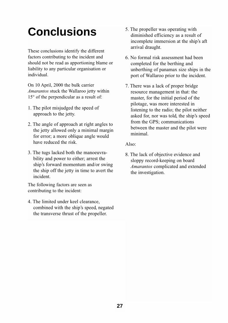
Conclusions These conclusions identify the differentfactors contributing to the incident andshould not be read as apportioning blame orliability to any particular organisation orindividual.
On 10 April, 2000 the bulk carrierAmarantos stuck the Wallaroo jetty within15° of the perpendicular as a result of:
1. The pilot misjudged the speed ofapproach to the jetty.
2. The angle of approach at right angles tothe jetty allowed only a minimal marginfor error; a more oblique angle wouldhave reduced the risk.
3. The tugs lacked both the manoeuvra-bility and power to either; arrest theship’s forward momentum and/or swingthe ship off the jetty in time to avert theincident.
The following factors are seen ascontributing to the incident:
4. The limited under keel clearance,combined with the ship’s speed, negatedthe transverse thrust of the propeller.
5. The propeller was operating withdiminished efficiency as a result ofincomplete immersion at the ship’s aftarrival draught.
6. No formal risk assessment had beencompleted for the berthing andunberthing of panamax size ships in theport of Wallaroo prior to the incident.
7. There was a lack of proper bridgeresource management in that: themaster, for the initial period of thepilotage, was more interested inlistening to the radio; the pilot neitherasked for, nor was told, the ship’s speedfrom the GPS; communicationsbetween the master and the pilot wereminimal.
Also:
8. The lack of objective evidence andsloppy record-keeping on boardAmarantos complicated and extendedthe investigation.

28

SubmissionsUnder sub-regulation 16(3) of theNavigation (Marine Casualty) Regulations,if a report, or part of a report, relates to aperson’s affairs to a material extent, theinspector must, if it is reasonable to do so,give that person a copy of the report or therelevant part of the report. Sub-regulation16(4) provides that such a person mayprovide written comments or informationrelating to the report.
The final draft of the report was sent to thefollowing:
Copies of the draft report were sent to:
The pilot, tug masters and wharfinger. Theowners, master, chief engineer and secondmate of Amarantos. The management ofPorts Corp South Australia. The MaltaMaritime Authority and the AustralianMaritime Safety Authority.
Submissions were received from the ownersand master of Amarantos, the pilot, PortsCorp South Australia and the wharfinger.The draft was amended and submissionsincluded as appropriate.
29
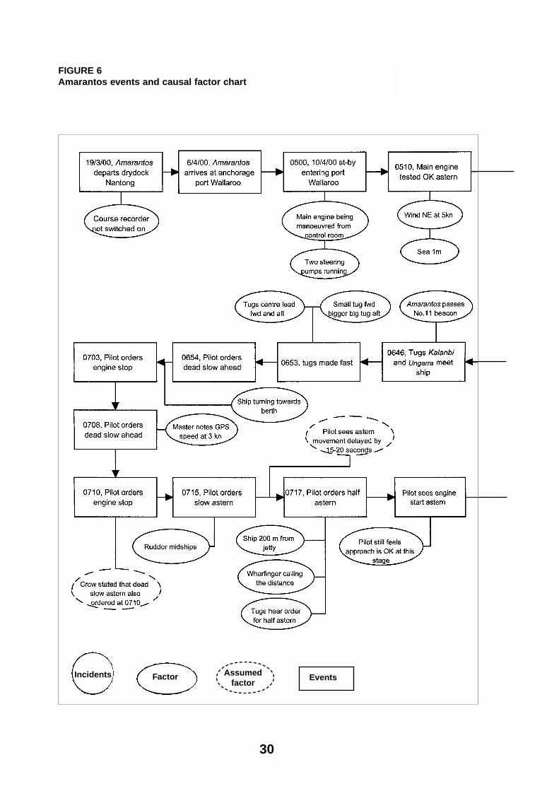
30
FIGURE 6Amarantos events and causal factor chart
Factor Assumed factor
EventsIncidents

31

32

Details of shipName Amarantos (formerly Ikan Beliak-97,
Ocean Pioneer-87 and Ikan Kerisi-86)
IMO No. 7918256
Flag Maltese
Classification Society Lloyds
Vessel type Panamax bulk carrier
Owner Amarantos Shipping Co. Ltd, Valletta, Malta
Year of build 1980
Builder Mitsubishi Heavy Industries Ltd, Kobe, Japan
Gross tonnage 35 650
Summer deadweight 64 957 tonnes
Length overall 224.00 m
Breadth, moulded 31.80 m
Depth 18.35 m
Draught (summer) 13.328 m
Engine Sulzer 6RND76M, 6-cylinder, 2-stroke, single acting
Engine power 10 592 kW
Service speed 14.75 knots
Crew 23 (Greek, Ukrainian, Filipino)
33