isig/web a web-based tool for viewing and editing maps month/2004 gustavo mandolesi – software...
Post on 21-Dec-2015
217 views
TRANSCRIPT

ISIG/WEBA Web-based Tool for
Viewing and Editing Maps
Month/2004
Gustavo Mandolesi – Software Engineer
2
Objective
Present an overview of ISIG/WEB by highlighting its
main functions and benefits within the context of
web-based GIS applications.

3
Contents
Introduction System components Architecture Demonstration Conclusion

4
Introduction

5
What is ISIG/WEB ?
It´s a software prototype for editing maps on the web
Result of a research project named ISIG
• “Inovação em Sistemas de Informações Geográficas”
• GIS Innovation
Sponsored by FUNTTEL
• Fundo para desenvolvimento Tecnológico das
Telecomunicações
• Fund for the Technological Development of
Telecommunications

6
On the Web...
Main features
• Map visualization
• Edition of georeferenced objects on maps
• Edition of map style (symbology)
All over HTTP !

7
Based on Open Standards
Open Geospatial Consortium (OGC) standards
• WMS – Web Map Service
• WFS – Web Feature Service
• SLD – Styled Layer Descriptor
• GML – Geographic Markup Language
World Wide Web Consortium (W3C) standards
• SVG – Scalable Vector Graphics
Java / J2EE
JavaScript

8
System Components

9
User Interface Modules
Map Viewer/Editor
• Visualization of SVG maps
• Thin client
• Web application (browser)
Style Editor
• SLD graphical or textual edition
• Fat client
• Desktop application

10
Service Modules
OGC Servers
• No interface, services only.
• Web Map Server (WMS)
• Web Feature Server (WFS)
XSLT Transformer
• GML + SLD SVG
Geographic Database Server
SERVICES

11
Who´s who
Map Viewer/Editor
• Internet Explorer 5.5
• Adobe SVG Viewer 3.0 (freeware plugin)
• Javascript
• Server-side components (Servlet´s and JSP´s)
Style Editor
• Java Swing (multiplatform)
• Java Web Start technology downloaded via browser
• Uses Apache Batik SVG Toolkit to build map symbols

12
Who´s who
Web Map Server
• deegree WMS 1.1.2
• Official reference implementation for the
OGC WMS 1.1.1 specification
• Java / J2EE
Web Feature Server
• deegree WFS 1.2.3
• Based on OGC WFS 1.0.0
• Java / J2EE
Oracle
WEB WEB
13
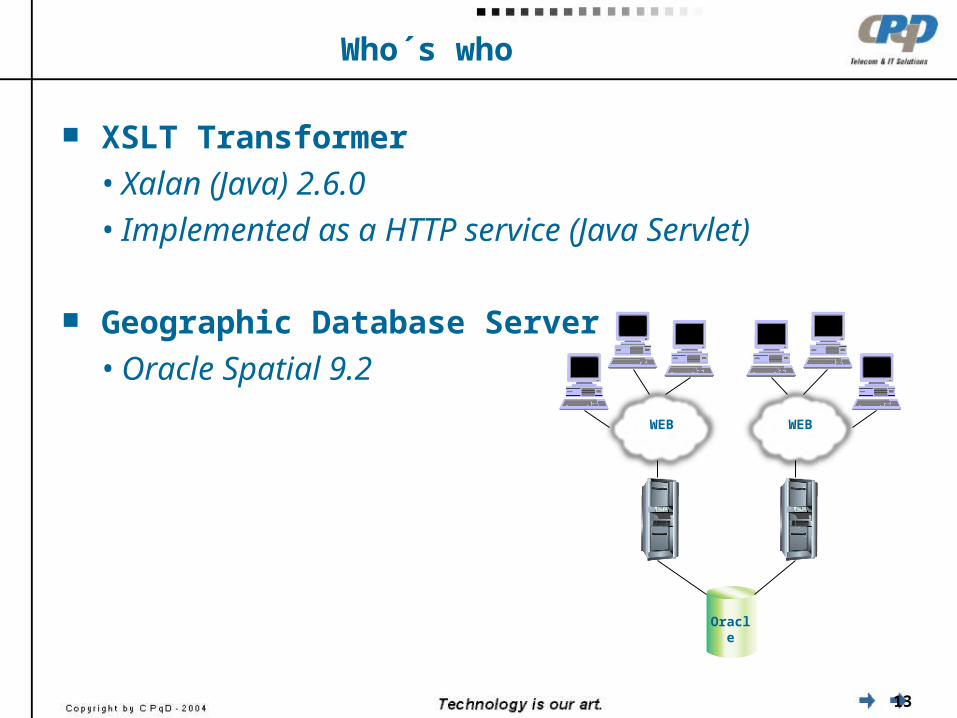
Who´s who
XSLT Transformer
• Xalan (Java) 2.6.0
• Implemented as a HTTP service (Java Servlet)
Geographic Database Server
• Oracle Spatial 9.2
Oracle
WEB WEB

14
Architecture

15
Architecture
OracleOracle
SpatialSpatial
deegreedeegree
WFSWFS
deegreedeegree
WMSWMS
XSLTTransformer
(GML + SLD = SVG)
WFStransactions
SVGmaps
GMLfeatures
Map Viewer/Editor Style Editor
SLD-related services

16
Architecture
Distributed Service-oriented
WEB
WMS
WFS
Web applicationserver
RDBMS
HTTP
HTTPHTTP

17
Architecture
Distributed Service-oriented
WEB
WMS
WFS
Web applicationserver
RDBMS
HTTP
HTTPHTTP

18
Demonstration

19
Conclusion
CPqD CPqD ISIG/WEBISIG/WEB

20
Conclusion
It is possible to edit maps on the web,
using open standards
It is possible to build a reliable internet GIS system
totally Java / J2EE based
SVG can be used sucessfully for rendering maps
with great quality

21
Conclusion
Future work:
• Adaptation of JavaScript code in order to use other
browsers, i.e. Mozilla Firefox 1.0 (Adobe SVG plugin)
• Migrate presentation code in order to use a browser
with native support of SVG.
Currently, Mozilla SVG (beta)
• Use other geographic databases
Data adaptation to use PostgreSQL / PostGIS
• Tests to improve performance of XML data traffic

22
Questions

THANK YOU!
Gustavo [email protected]: +55 (19) 3705.4588
CPqD – Centro dePesquisa e Desenvolvimento
em TelecomunicaçõesRod. Campinas–Mogi-Mirim, km 118,5 – SP340
13086-902 – Campinas – SPBRASIL
www.cpqd.com.br
CPqD Technologies & Systems, Inc.101 NE Third Ave – Suite 1500
Fort Lauderdale, FL 33301, USAwww.cpqdusa.com