issn: geodetic monitoring methods of high … · levels, opportunity to carry out supervision in...
TRANSCRIPT

Journal of Theoretical and Applied Information Technology 15
th November 2016. Vol.93. No.1
© 2005 - 2016 JATIT & LLS. All rights reserved.
ISSN: 1992-8645 www.jatit.org E-ISSN: 1817-3195
24
GEODETIC MONITORING METHODS OF HIGH-RISE
CONSTRUCTIONS DEFORMATIONS WITH MODERN
TECHNOLOGIES APPLICATION
1 M.E.KUTTYKADAMOV,
2 K.B.RYSBEKOV, ,
3 I. MILEV,
4 K.A.YSTYKUL,
5 BEKTUR B.K.
1 PhD Doktor, Kazakh national research technical university of K. Satpayev, Almaty, Kazakhstan
2Assoc. Prof., Kazakh national research technical university of K. Satpayev, Almaty, Kazakhstan
3 PhD Doktor, Prof., Managing Director Technet-rail, Berlin, Germany
4 PhD Doktor, Kazakh national research technical university of K. Satpayev, Almaty, Kazakhstan
5 PhD Doktor, Kazakh national research technical university of K. Satpayev, Almaty, Kazakhstan
E-mail: 1
[email protected] , 2 [email protected] ,
ABSTRACT
In article the analysis of the high-rise buildings and constructions deformation processes geodesic
monitoring method is provided. The purpose of geodetic monitoring consists in surveying technology use
including a processing and comparing algorithm of observations cycles results on the selected clusters and
providing monitoring of the object deformed status on all it surface. The analysis and synthesis of domestic
and foreign experience of high-rise buildings and constructions deformation processes geodesic monitoring
was carried out. Advantage of the geodesic monitoring methods using a surface laser scanning technology
allowing increasing safety in case of high-rise buildings construction and operation is shown.
Keywords: High-Rise Buildings, Surface Laser Scanners, Deformation, Monitoring, Monitoring Methods,
Technology.
1. RELEVANCE
Now in Kazakhstan intensive development of the
city space territory including underground is actively
conducted. At the same time in connection with
increase in the land plots cost a building density
and a tendency of high-rise constructions is
observed. In these conditions there is a need of these
objects' deformation processes observations
considering that they are most sensitive to
environment state changes [3, 11].
All this leads to change of requirements to the
determination accuracy of the buildings and
constructions geometrical sizes and also to errors
definition which arise at designs installation, laying
the buildings and constructions foundation. [3].
At the same time the probability of a soil surface
deformations emergence for large megalopolises
what Almaty becomes the considerable.
Deformations can be caused by both technogenic
and quite natural factors: buildings and constructions
pressure upon soil, large-scale multystoried
construction, intensive development of underground
space (the subway lines, different type’s
communications, etc.), increase of transport streams,
change of ground waters level and so forth.
Especially considering that the southern and
southeast Kazakhstan territory the Almaty district
including, is one of the most earthquake zone in the
CIS (Commonwealth of Independent States). On the
geological basis added with elements of the latest
tectonics and seismic dislocation, distribution of the
largest earthquakes epicenters of the past and
modern seismicity manifestation the purposeful
choice of the areas for geodetic networks creation
for the purpose of soil surface modern movements
studying in various geological tectonic conditions is
carried out.
Intensive development of the city space territory
is conducted. At the same time in connection with
increase in the land plots cost the tendency of high-
rise constructions building is observed. In these
conditions there is a need of supervision of these
objects deformation processes, considering that they
are most sensitive to an environment state changes
[3], [11].
2. ANALYSIS OF EXISTING RESEARCH
Prerequisites for the solution of a problem of
high-rise constructions deformations definition are in
many respects put in the operating standard and
Journal of Theoretical and Applied Information Technology 15
th November 2016. Vol.93. No.1
© 2005 - 2016 JATIT & LLS. All rights reserved.
ISSN: 1992-8645 www.jatit.org E-ISSN: 1817-3195
25
methodical literature according to various
engineering constructions deformations. In this
regard the significant contribution to development of
this geodetic works direction was made by the
famous scientists: I.Yu. Vasyutinsky, V.N. Ganshin,
Yu.P. Gulyaev, B.N. Zhukov, A.K. Zaytsev, A.A.
Carlson, E.B. Klyushin, G.P. Levchuk, G.A.
Shekhovtsov, etc.
Use of modern measurements technologies and
their processing in relation to the considered subject
is reflected in researches A.V. Komissarov, E.M.
Medvedev, A.I. Naumenko, A.V. Seredovich, V.A.
Seredovich.
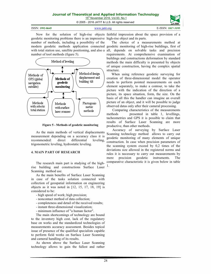
Analyzing a scientists’ research we will consider
the geodetic monitoring methods according to the
figure 5. The direct leveling method with the short
collimating ray application a beam 3 to 25 m long is
most widespread. The main advantages of this
method are: high precision and speed of outreaching
measurements on stations, a wide choice of exact
levels, opportunity to carry out supervision in the
constrained conditions of construction [11, 13].
Excess between points at distance of 5-10 m is
possible to determine with an accuracy of 0,05-0,1
mm and at distance of hundreds of meters - with an
accuracy of 0,5 mm. Marks of deformation points
(deformation control benchmarks) for the entire
supervision period determine rather Borros point or
group of benchmarks. The received results equalize,
estimate the actual accuracy of marks, on differences
of marks in cycles build the schedules of settlements.
In the course of supervision over settlements in each
measurements cycle the control of vertical angle
bench mark stability is carried out [3]. At the same
time for determination of position level stability
there is a number of widespread methods [6, 10], and
the smaller attention is paid to planned stability.
Besides, electronic (digital) levels with special bar
code laths for which coding RAB and BAR codes
[16] are used are successfully applied to supervision
over deformations.
Full leveling process automation is reached due
to reading of counting on a lath, fixing of horizontal
distance to it, and also calculation of excess between
points. Besides the minicomputer which is built in
the device allows to keep data and also to often
conduct their handling and equalization directly in
the field. It is noted that possibilities of digital levels
provide performance improvement for 50% in
comparison with traditional optical-mechanical
devices [1, 2]. In [7, 11] is specified that when
conditions of a construction complicate application
of direct differential leveling, for measurement a
settlement of constructions use trigonometric
leveling by short beams up to 100 m long. At the
same time the corresponding instrument row shall
include exact and high-precision theodolites with
superimposed cylindrical levels or total stations [7].
Besides, for observations the conditions allowing
reducing the vertical refraction influence [11] shall
be chosen. The hydrostatic leveling based on use of
liquid balance laws in communicating vessels is
applied to measurement a points relative vertical
movements under following conditions:
inaccessibility of other methods of movements
accounting; lack of visibility between brands;
impossibility of the person in a workplace
(observance of safe engineering). But if the building
or a construction experiences dynamic loads, then
the method of hydrostatic leveling isn't applied [7].
Instrumentally the method can be provided with
figurative hose levels, stationary hydrostatic or
hydrodynamic systems, for example [15]. However
it should be noted that application of hydraulic
systems is connected with considerable
organizational and technological difficulties
therefore cases of their use are single [17].
Use of total stations by production of land works
is really comprehensive. These devices found the
niche, including, when conducting geodetic
monitoring of engineering objects, at the accounting
of deformation processes. Certainly, it is promoted
by considerable accuracy: angular measurements
reach 0°00’0,5", distances - 0,5 mm + 1 mm/km (1
mm + 1 mm/km in the reflectorless mode).
Mass distribution was gained now by robotic
tacheometers with the servo-drivers providing
automatic rotation around an axis of the tool and
rotation of the telescope. In such devices the
possibility of uninterrupted tracking reflectors at
huge distances is realized. At the same time special
software automatically reads out receptions data of
separate sessions and results possible movements of
the purposes for the concrete time period.
The standard diagram of observations over
engineering objects deformation processes with
robotic tacheometers use agrees to [4, 21] is
provided in a figure 1 and is summarizing to the
following procedures:
- installation of the instrument in the stable place
providing the wide review of an observations object
and not subject to deformation influences.
In case of impossibility of these conditions
observance it is possible to use control station in the
form of reflective prisms concerning which the
tacheometer position is defined by three-point
method;
- fixing of special reflectors in ordinance-datum
of an object;
Journal of Theoretical and Applied Information Technology 15
th November 2016. Vol.93. No.1
© 2005 - 2016 JATIT & LLS. All rights reserved.
ISSN: 1992-8645 www.jatit.org E-ISSN: 1817-3195
26
- periodic observation of reflectors position in a
local coordinate system;
- comparing of observations cycles of spatial
provision of reflectors ordinance-datum.
The main direction of total stations development
is still the further robotizing reducing user functions
to distant monitoring and control of the instrument
operation . Also there is a tendency to equipment the
instruments with GPS systems.
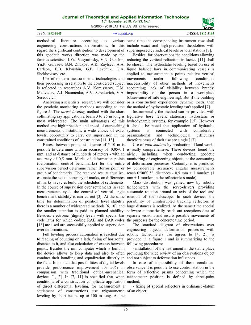
At the same time tacheometers in a combination
with navigation receivers, digital levels and other
instruments, and also the special controlling software
(S) often form special automated geodesic
monitoring systems (a figure 1).
Figure 1 - Monitoring Of The Building With The
Robotic Tacheometer Use
Factors of the global navigation satellite systems
(GNSS) wide use are: a continuity of coordinates
determination, an all-weather capability, efficiency
of coordinates determination, high precision of the
received results, small dimensions and weight of
receivers, small power consumption, simplicity of
operation and rather low cost.
Unlike many alternative methods which are
carried out with a certain interval, various objects
deformations monitoring with application of satellite
methods can be continuous as in real time, and at a
post-processing stage. At the same time possibilities
of these methods are actively used at the accounting
of deformation processes of various engineering
objects.
In relation to high-rise constructions in [9] is
noted that devices of GPS positioning allow to
determine spatial coordinates of points with an
accuracy of 1 cm that for high-rise structures with
possible horizontal movements about several tens
centimeters represent quite high precision. At the
same time the exception of mistakes in case of
measurements can be made in case of a supervision
differential method.
Measurements should be carried out by means of
two groups of receivers: established in controlled
points of an object (rovers) and located in points
with the known coordinates (base stations). The
differential mode basic allows to fix not absolute
coordinates of the rover stations, but their position
referred to basic. It is noted that the accuracy of
phase measurements reaches millimetric accuracy.
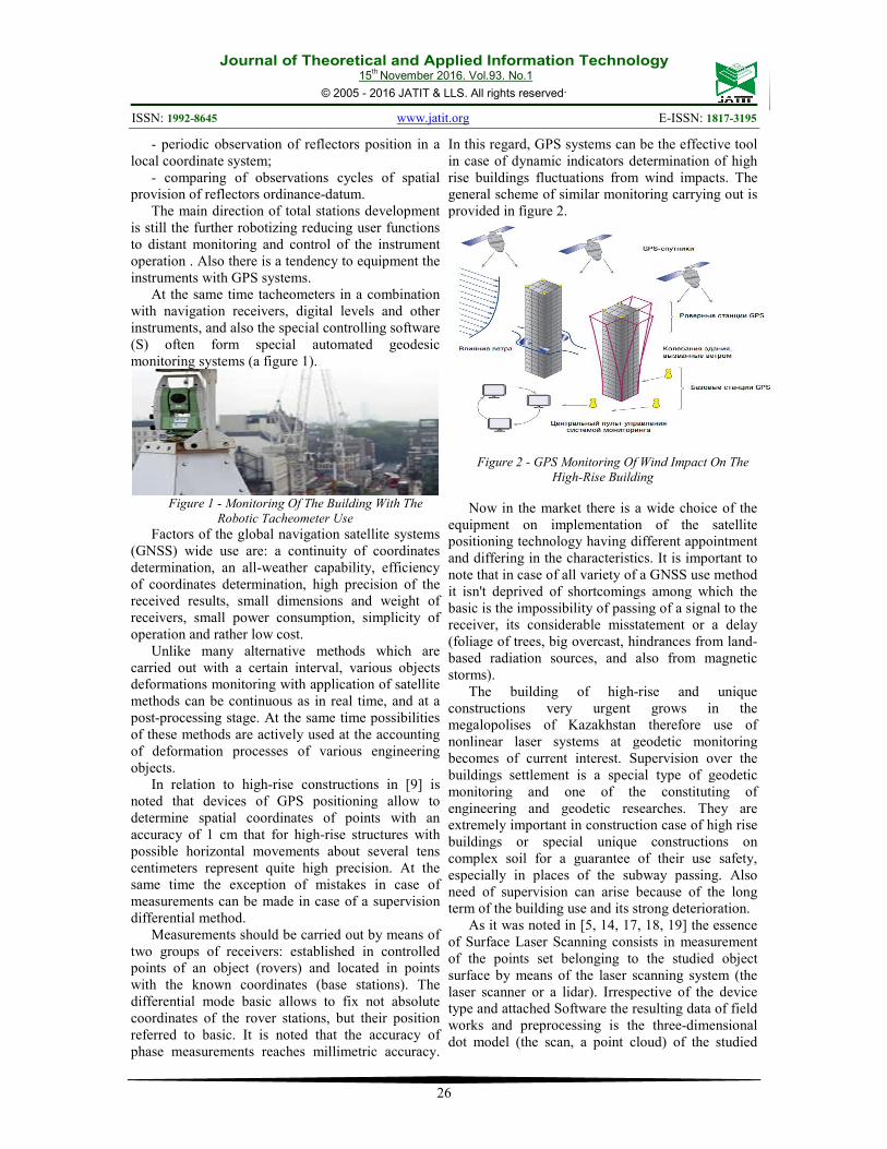
In this regard, GPS systems can be the effective tool
in case of dynamic indicators determination of high
rise buildings fluctuations from wind impacts. The
general scheme of similar monitoring carrying out is
provided in figure 2.
Figure 2 - GPS Monitoring Of Wind Impact On The
High-Rise Building
Now in the market there is a wide choice of the
equipment on implementation of the satellite
positioning technology having different appointment
and differing in the characteristics. It is important to
note that in case of all variety of a GNSS use method
it isn't deprived of shortcomings among which the
basic is the impossibility of passing of a signal to the
receiver, its considerable misstatement or a delay
(foliage of trees, big overcast, hindrances from land-
based radiation sources, and also from magnetic
storms).
The building of high-rise and unique
constructions very urgent grows in the
megalopolises of Kazakhstan therefore use of
nonlinear laser systems at geodetic monitoring
becomes of current interest. Supervision over the
buildings settlement is a special type of geodetic
monitoring and one of the constituting of
engineering and geodetic researches. They are
extremely important in construction case of high rise
buildings or special unique constructions on
complex soil for a guarantee of their use safety,
especially in places of the subway passing. Also
need of supervision can arise because of the long
term of the building use and its strong deterioration.
As it was noted in [5, 14, 17, 18, 19] the essence
of Surface Laser Scanning consists in measurement
of the points set belonging to the studied object
surface by means of the laser scanning system (the
laser scanner or a lidar). Irrespective of the device
type and attached Software the resulting data of field
works and preprocessing is the three-dimensional
dot model (the scan, a point cloud) of the studied

Journal of Theoretical and Applied Information Technology 15
th November 2016. Vol.93. No.1
© 2005 - 2016 JATIT & LLS. All rights reserved.
ISSN: 1992-8645 www.jatit.org E-ISSN: 1817-3195
27
object representing a set of points with the known
coordinates X, Y, Z (figure 3).
Figure 3 - Example Of A Point Cloud Of The Building
Facade
Now surface lidars are provided by the models
wide range differing in technical parameters, the
action principle, overall dimensions and application
methods. At the same time the main features
defining possibilities of the instrument are range of
action and accuracy [14, 19, 20].
In the context of Surface Laser Scanning
application for collecting data about high-rise
objects it is necessary to be guided by an instrument
choice with high range of action and accuracy. The
triangulation scanners realizing an intersection
method of distance measurement to an object have
accuracy from 50 microns to 0,3 mm in case of
action range from tens of centimeters to 25 m.
Traditionally ranges of these devices application are
the mechanical engineering, medicine, etc. [19, 20].
The limited range of action insufficient for Surface
Laser Scanning of high-rise objects excludes
triangulation scanners from further reviewing.
In the course of scanning the direction of a laser
beam distribution and distance to object points is
fixed. The raster image – the scan which pixels
values represent the vector elements with the
following components: the measured distance,
intensity of the reflected signal and the RGB-
component characterizing real color of a point is a
result of the scanner operation. And also gives the
most complete and exact idea of constructive and
technological elements on an object. For the
majority of the Surface Laser Scanning models the
characteristic of real color for each point it turns out
by means of the nonmetric digital camera. The raw
data of laser scanning in the form of "clouds" of
points allow revealing in the automated mode
deviations from the project in real time.
Pulse and phase reflectorless methods of
distances measurement and also method of direct
angular reamer (triangulation method) are put in a
basis of the laser distance meter work used in
scanners.
The difference of the output and input light
waves phases is measured in a phase method for
distance determination. Scanners where the similar
technology is applied can provide data acquisition
productivity to 1 million points a second with an
accuracy of 1 mm, at the same time range of action
reaches about 300 m. Time of a light impulse
passing is measured in a pulse method for
determination of distance. The scanner lets out short
light impulses and measures time for which light
reflected from a subject comes back. Usually such
scanner provides the accuracy of measurements of 3
- 6 mm with a productivity about 100000 points a
second. At the same time distance measured by these
devices can make up to 6 km.
Thus general benefits of a pulse method over a
phase one is high range of action in case of an
impulse rather low capacity, unambiguity of the
received result (the measured range is pro rata to
time of a signal pass). Accuracy of measurements
and performance of works belongs to method
shortcomings smaller in comparison with a phase
method.
Management of the land laser scanner operation
is perhaps direct from the PC (laptop) through a
special cable or wireless connection (Wi-Fi,
Bluetooth).
The comparative analysis of a high-rise
construction deformation geodetic monitoring use
showed advantages and prospects of Surface Laser
Scanning.
3. MAIN OBJECTIVE OF RESEARCH
The purpose of geodetic monitoring is timely
identification of deformations critical sizes,
establishment of their emergence reasons, drawing
up forecasts of deformations development,
development and taking measures for undesirable
processes elimination.
Non-performance of geodetic monitoring or non-
execution of surveyor’s instructions leads to sad
consequences (figure 4).
Figure 4 - Yield Of The Building Foundation
Journal of Theoretical and Applied Information Technology 15
th November 2016. Vol.93. No.1
© 2005 - 2016 JATIT & LLS. All rights reserved.
ISSN: 1992-8645 www.jatit.org E-ISSN: 1817-3195
28
Now for the solution of high-rise objects
geodetic monitoring problems there is an impressive
number of methods, including a possibility of the
modern geodetic methods application connected
with total station use, satellite positioning, and also a
number of tool methods (figure 5).
Figure 5 - Methods of geodetic monitoring
As the main methods of vertical displacements
measurement depending on a accuracy class it is
recommended: direct differential leveling,
trigonometric leveling, hydrostatic leveling.
4. MAIN PART OF RESEARCH
The research main part is studying of the high-
rise building and constructions Surface Laser
Scanning method use.
As the main benefits of Surface Laser Scanning
in case of the tasks solution connected with
collection of geospatial information on engineering
objects as it was noted in [12, 15, 17, 18, 19] is
considered to be:
- high speed of work; high precision;
- noncontact method of data collection;
- completeness and detail of the received results;
- instant three-dimensional visualization;
- minimum influence of "a human factor".
The main shortcomings of technology are bound
to the inventory high cost, lack of the regulatory
base on works and the standardized technologies of
measurements accuracy assessment. Besides topical
issue of presence of the qualified specialists capable
to perform field works on Surface Laser Scanning
and cameral handling of its results.
As shown above the Surface Laser Scanning
technology allows to gain the fullest and rather
faithful impression about the space provision of a
high-rise object and its parts.
The choice of a measurements method at
geodetic monitoring of high-rise buildings, first of
all, depends on solvable tasks and precision
requirements. At comprehensive examination of
buildings and constructions deformation by standard
methods the main difficulty is presented by objects
of unique construction, having the complex spatial
structure.
When using reference geodetic surveying for
creation of three-dimensional model the operator
needs to perform pointed measurements on each
element separately, to make a contour, to take the
picture with the indication of the direction of a
picture, its space situation, form, the size. On the
basis of all this the handler can imagine an overall
picture of an object, and it will be possible to judge
observed datas only after their cameral processing.
Comparing characteristics of the measurements
methods presented in table 1, levellings,
tacheometries and GPS it is possible to claim that
results of Surface Laser Scanning are more
productive, than other methods.
Accuracy of surveying by Surface Laser
Scanning technology method allows to carry out
geodetic monitoring of many elements of unique
construction. In case when precision parameters of
the scanning system exceed by 0,2 times of the
deviations size allowed in the registered norms and
rules it is necessary to carry out measurements by
more precision geodetic instruments. The
comparative characteristic it is given below in table
1.

Journal of Theoretical and Applied Information Technology 15
th November 2016. Vol.93. No.1
© 2005 - 2016 JATIT & LLS. All rights reserved.
ISSN: 1992-8645 www.jatit.org E-ISSN: 1817-3195
29
Table1-Comparative characteristic of measurements methods
Referent criterion Leveling Tachymetry GPS Laser scanning
Standard error (SE)
of location survey, m
in the plan,
0,010
on height,
0,002
in the plan,
0,250
on height
0,020
in the plan,
statics 0,010
kinematics
0,020
on height,
statics 0,010
kinematics
0,020
in the plan,
0,030
on height,
0,030
Terms of field works
performance,
10 hectares /day
10 /15
10/7
10 / 5
10 /1
Terms of office
operations
performance,
days
3 5 5 15
Performers, persons 3 2 1 1
Gauging speed
Single
measurements
(influence of a
human factor)
Single
measurements
(influence of a
human factor)
time:100
nanoseconds
speed: 0.1 m/s
1 000 000
measurements/sec.
(are completely
automated)
Result
Creation of the
topographic
map 1:500
Creation of the
topographic
map 1:500
Creation of
the
topographic
map 1:500
Creation of the
topographic map
1:500 (a 3D
creation possibility
according to the
obtained data)
It was widely assumed that the main works
problem on technical condition monitoring of high-
rise objects with use considered technologies is not
so much surveying process which, in fact, is
completely automated how many its results
processing technique. Yes it is possible to agree with
it, but there are not resolved issues on errors which
come to light in the course of surveying. This is the
scanner installation site, diameter of a laser bunch
which depends on a corner and distance from the
removed object.
5. CONCLUSIONS
Advantage of Surface Laser Scanning in
comparison with traditional methods is shown,
especially when conducting monitoring a high-rise
buildings and constructions condition, the consisting
of possibilities of quick data acquisition with the
subject high density measurements.
In the context of Surface Laser Scanning
application for acquisition about high-rise objects it
is necessary to be guided by the choice of the device
with high range of action and accuracy.
At the same time there are difficulties when
processing results, especially it is shown at a
stitching the images received from different places
of objects scanning. It is caused by differences of
measurement accuracy of various sites of a objects
surface and depends on distance to the scanner and
the scanning angle.
It should be noted, as in case of the building
scanning from the same place because of distinction
in distance from the scanner to the site of a surface
and the scanning angle accuracy will also be various.
In this regard there is a need for development a way
of the place choice of the high-rise building and
construction Surface Laser Scanning, providing its
effectiveness at the greatest possible measurement
accuracy.
Journal of Theoretical and Applied Information Technology 15
th November 2016. Vol.93. No.1
© 2005 - 2016 JATIT & LLS. All rights reserved.
ISSN: 1992-8645 www.jatit.org E-ISSN: 1817-3195
30
To reach a high precision when scanning the
high-rise building it is necessary to define optimum
distance from an object and the angle of scanning
depending on building height.
Having resolved above the stated issues it is
possible to claim that it is possible to apply Surface
Laser Scanning technology to carrying out geodetic
monitoring of deformations of high-rise
constructions at construction and operation of
various, including unique, engineering objects.
REFERENCES
[1] Azarov, B. F. Modern methods of engineering
constructions deformations geodetic
observations / B. F. Azarov// Polzunovsky
messenger - Barnaul, 2011.-№ 1. - Page 19-29.
[2] Afonin D. A. Geodetic control of deformations in
case of a city underground constructions by
an open method: Extended abstract of
Cand. Sci. Dissertation: 25.00.32/ Afonin
Dmitry Andreevich. – SPb, 2013. – 22 pages.
[3] Valkov, VA. Geodetic monitoring of high-rise
constructions using land laser scanning
technology/VA.Valkov,A.A.
Yakovlev//Natural and technical science. –
2015. – No. 2. – Page 58-61.
[4] Nazarov I. A. Taking note on measurements
accuracy by refractorless electronic
tacheometers of laser beam tilt angle and
the reflecting properties of a surface: Edited
volume of MGSU (MISI). - M, 2006..
[5] Valkov VA. Application of land laser scanning
for creation of three-dimensional digital
models of the Shukhovsky tower/VA.
Valkov, M. G. Mustafin, G. V.
Makarov//Notes of Mining institute. –2013.
– volume 204. – Page 58
[6] Ganshin V. N. Measurement of constructions
vertical displacement and the analysis of
registration mark stability / V. N. Ganshin,
A. F. Storozhenko, A. G. Ilyin, etc. - M.:
Nedra. - 1981. - 215 pages.
[7] All-Union standard 24846-2012. Soil.
Measurement methods of buildings and
constructions foundations deformations
[Text]. - enacted 2013 – 07 – 01. – Moscow:
Interstate Council for standardization, metrology
and certification; Moscow: Standartinform,
2014. –18 pages.
[8] Kuttykadamov M. E., Rysbekov K. M. Benefits
of three- dimensional laser scanning in case
of highways certification. Problems of a
subsoil development in the 21st century
through young people's eyes. 10th international
scientific school of young scientists and
specialists. Moscow IPKON RAHN 2013.
[9] Primbektova A., Rysbekov K. B., Kuttykadamov
M.E, Aytkazinova Sh. Implementation of the
laser scanning technologies of geodetic works.
Almaty: Collection of works of the
International scientific and practical conference
"Innovative Technologies and Projects in a
mining and smelting enterprise, Their
Scientific and Personnel Maintenance". – On
March 18-19, 2014, Page 443-445
[10] Korgin A. V. Monitoring of vital constructions
technical condition with use of measurements
modern geodetic methods and the numerical
analysis of finite-element method / A.V.
Korgin, M. A. Zakharchenko, V. A.
Ermakov//Monitoring. Science and safety. -
2011. - No. 3. – Page 58-63.
[11] Levchuk G. P. Applied geodesy. Geodetic
works in case of engineering constructions
researches and construction. The textbook
for higher education institutions / G. P.
Levchuk, V. E. Novak, N. N. Lebedev. -
M.: Nedra. – 1983. – 400 pages.
[12] Seredovich A. V. Use of the RISCAN PRO
software product for registration of scans [An
electronic resource] /
A.V.Seredovich,A.V.Ivanov, O. A.
Dementieva//Interekspo Geo-Siberia. – 2011.
– No. 2.
[13] Gorelov V. A., Nazarov I. A. Features of a
technique of geometrical leveling by short
collimating ray in relation to high-rise
construction: Edited volume of MGSU
(MISI). - M, 2006..
[14] Seredovich,VA. Surface laser scanning [Text]:
Monograph/ V. A. Seredovich [etc.]. –
Novosibirsk: SGGA, 2009. – 261 pages.
[15] Ustavich G. A., Oleynik A. M., Shalygina E. L.
Development of multilevel double hydrodynamic
system//News of higher education institutions.
Geodesy and aerial photography. – 2004. –
№ 1. – Page 40-53.
[16]Shekhovtsov G. A. Modern geodetic methods of
engineering constructions deformations
definition: monograph / G. A. Shekhovtsov, R.
P. Shekhovtsova//. —
Nizhny Novgorod: NNGASU. - 2009. — 156
pages.
[17]3D Scanning Becomes an Everyday Tool
[digital resource]// Technology & more. -
2011. - №2.-pp.15-16.- access mode:

Journal of Theoretical and Applied Information Technology 15
th November 2016. Vol.93. No.1
© 2005 - 2016 JATIT & LLS. All rights reserved.
ISSN: 1992-8645 www.jatit.org E-ISSN: 1817-3195
31
http://www.trimble.com/ technology and
more/i2-2011/
[18] Valkov V.A. Creation of three-dimensional
digital models of high-rise buildings and
facilities based on surface laser scanning /
V.A. Valkov // Scientific reports on resource
issues:Efficiency and Sustainability in the
Mineral Industry. – Freiberg: TU
BergakademieFreiberg, 2013. – V.1. – Part II.
– P. 74-77.
[19] Berenyi A. Surface laser scanning - civil
engineering applications/ A. Berenyi, T. Lovas,
A. Barsi. // International Archives of
Photogrammetry, Remote Sensing and Spatial
Information Sciences, Vol. XXXVIII, Part 5. –
Commission V Symposium. - Newcastle upon
Tyne, UK. - 2010. - pp. 80-85;
[20] Information website of the Autodesc company:
http://www.autodesk. com/products/ recap/
overview
[21] Information website of the Navgeokom
company:http://
www.navgeocom.ru/solutions/monitoring-
deformatsiy/