iv feasibility to develop three dimensional...
TRANSCRIPT

iv
FEASIBILITY TO DEVELOP THREE DIMENSIONAL NATIONAL DIGITAL
CADASTRE DATABASE USING REMOTE SENSING DATA
SITI ZAINUN BINTI MOHAMAD
A thesis submitted in fulfilment of the
requirements for the award of the degree of
Master of Science (Geomatic Engineering)
Faculty of Geoinformation and Real Estate
Universiti Teknologi Malaysia
JUNE 2016

vi
Specially dedicated to Mak and Abah
(Rapiah binti Mat Sam dan Mohamad bin Yaakob)
Ini kali keduakan dan doakan pasti ada untuk kali ketiga….
To my beloved husband
(Mohd Jeffri bin Nurul Huda)
You mean everything to me
To 3Sitiku
Siti Aisyah, Siti Balqis dan Siti Hajjar
Mesti lebih terbaik dari ibu yer….

vii
ACKNOWLEDGEMENT
Alhamdulillah. First and foremost, I wish to express my heartiest
appreciation to my main thesis supervisor, Assoc. Prof. Kamaludin bin Mohd Omar
and my Co-Supervisor Dr. Abdullah Hisam bin Omar for support, enthusiasm and
the valuable guidance throughout the period of supervision, the Department of
Geoinformation staffs, members for the support and Department of Survey and
Mapping Malaysia (DSMM) for providing valuable data used in this study. Special
thanks to DSMM State of Johor in assisting me to complete my study. Also for all
the invaluable excellent guidance, technical support, encouragement, concern and
critics advices and friendship.
Last but surely not least, I am deeply grateful to my lovely family members
especially to my beloved husband Mohd Jeffri bin Nurul Huda for his unlimited
patience, loving inspiration most enthusiastic support during the whole tenure of my
research. My sincere appreciation to my parents Mohamad bin Yaakob and Rapiah
binti Mat Sam for their encouragement, advice and who taught me the value of hard
work.

viii
ABSTRACT
National Digital Cadastre Database (NDCDB) contains 40 million boundary
marks that are based on Geocentric Datum of Malaysia (GDM 2000) for Peninsular
Malaysia and Federal Territories of Malaysia. Currently, the NDCDB is a two-
dimensional (2D) planimetric coordinate database without elevation information.
Enhancement of the existing NDCDB is needed in order to suit the current situation
and demands for real world modelling. One way to deal with this situation is to
upgrade the current database to a three dimensional (3D) Cadastre Database that
provide 3D information about land. The objectives of this research are: i) to
investigate and to examine the feasibility of developing the 3D NDCDB; ii) to
develop a new method for providing height information in cadastre survey and iii) to
evaluate the accuracy of height information generated from Light Detection and
Ranging (LiDAR), Interferometric Synthetic Aperture Radar (IFSAR) and cadastre
survey. Development of the 3D NDCDB involves the introduction of height
information into the existing cadastre boundary marks (CBMs), extracted from
various data sources such as LiDAR for urban areas in Mukim Setapak, Kuala
Lumpur, IFSAR for rural areas in Mukim Simpang Kiri, Batu Pahat, Johor and from
field observation in cadastre survey using the trigonometric levelling technique for
new CBMs at lot 48330, Bandar Johor Bahru. The trigonometric levelling technique
is used to determine the elevation difference between two stations by the triangle
formula. The evaluation of accuracy of height information generated from existing
CBMS is based on Root Mean Square Error (RMSE) and the accuracy of new CBMs
is evaluated with reference to the accumulated error from Cadastre Reference Mark
to CBMs. The results showed that the accuracy of vertical RMSE of generated
height information for existing CBMs is ±11cm for LiDAR and suitable to be
introduced into 3D NDCDB for urban areas. For rural area, the height accuracy is
±0.7m for IFSAR. The accuracy derived for new CBMs is ±8cm and it shows that
trigonometric levelling technique is suitable to produce height information into new
CBMs with several improvement in field data observation practices.
ix
ABSTRAK
Pangkalan data digital kadaster kebangsaan (NDCDB) mengandungi 40 juta
batu sempadan yang merujuk kepada Datum Geosentrik Malaysia bagi
Semenanjung Malaysia dan Wilayah-wilayah Persekutuan di Malaysia. Pada masa
kini, maklumat ini disimpan di dalam pangkalan data koordinat planimetrik dua
dimensi (2D) dan tanpa maklumat ketinggian. Penambahbaikan kepada NDCDB
sedia ada diperlukan bagi memenuhi keperluan masa kini dan permintaan kepada
model sebenar rupa bumi. Salah satu cara bagi menangani keadaan ini adalah
dengan menambahbaik pangkalan data sedia ada kepada pangkalan data tiga
dimensi (3D) kadaster untuk menyediakan maklumat tanah 3D. Objektif kajian ini
adalah: i) untuk menyiasat dan mengkaji kesesuaian membangunkan NDCDB 3D;
ii) untuk membangunkan satu kaedah baru untuk menjana maklumat ketinggian
dalam pengukuran kadaster dan iii) untuk menilai ketepatan maklumat ketinggian
yang dijana daripada pengesanan cahaya dan jarak (LiDAR), citra radar sintetik
interferometri (IFSAR) dan pengukuran kadaster. Pembangunan NDCDB 3D
melibatkan pengenalan maklumat ketinggian ke dalam tanda sempadan kadaster
sedia ada (CBMs) dan ianya diterbitkan daripada pelbagai sumber data seperti
LiDAR bagi kawasan bandar di Mukim Setapak, Kuala Lumpur, IFSAR bagi
kawasan luar bandar di Mukim Simpang Kiri, Batu Pahat, Johor dan juga
pengukuran kadaster di lapangan menggunakan kaedah ukur aras trigonometri bagi
CBMs baru di lot 48330, Bandar Johor Bahru. Kaedah ukur aras trigonometri
digunakan untuk menentukan perbezaan ketinggian di antara dua stesen
menggunakan formula segitiga. Penilaian ketepatan menegak bagi maklumat
ketinggian dihasilkan dari CBMs sedia ada adalah berdasarkan ralat purata punca
kuasa dua (RMSE) dan ketepatan CBMs baru dinilai dengan merujuk kepada ralat
terkumpul daripada Tanda Rujukan Kadaster ke CBMs. Keputusan menunjukkan
ketepatan menegak RMSE dihasilkan oleh maklumat ketinggian untuk CBMs sedia
ada adalah ±11cm bagi LiDAR dan sesuai diperkenalkan ke dalam NDCDB 3D
bagi kawasan bandar. Untuk kawasan luar bandar, ketepatan menegak adalah ±0.7m
bagi IFSAR. Ketepatan yang diperolehi bagi CBMs baru adalah ±8cm dan ia
menunjukkan bahawa kaedah ukur aras trigonometri adalah sesuai digunakan bagi
menghasilkan maklumat ketinggian CBMs baru dengan beberapa penambahbaikan
dalam amalan cerapan data lapangan.

x
TABLE OF CONTENTS
CHAPTER TITLE PAGE
DECLARATION ii
DEDICATION vi
ACKNOWLEDGEMENT vii
ABSTRACT viii
ABSTRAK ix
TABLE OF CONTENTS x
LIST OF TABLES xv
LIST OF FIGURES xvi
LIST OF ABBREVIATION xx
LIST OF APPENDICES xxii
1.0 INTRODUCTION 1
1.1 General Background 1
1.2 Research Motivation 4
1.3 Problem Statement 6
1.4 Research Objective 8
1.5 Significance of Research 8
1.6 Organization of Thesis 10
2.0 LITERATURE REVIEW 11
2.1 Introduction 11
2.2 Overview of Cadastre 11

xi
2.2.1 3D Cadastre 13
2.2.2 Needs for Third-Dimensional Information in
3D Cadastre 14
2.3 Malaysian Cadastre System 14
2.3.1 Cadastre Survey Modernization in Malaysia 15
2.3.2 Reform in Cadastre Survey 17
2.3.3 Use of Global Navigation Satellite System 17
2.3.4 Geocentric Datum of Malaysia 18
2.3.4.1 Malaysian Active GPS System 19
2.3.4.2 Malaysian Primary Geodetic Network
2000 19
2.3.4.3 Malaysian Real-Time Kinematic GNSS
Network 19
2.3.4.4 Development of Cadastre Control
Infrastructure 21
2.3.5 eCadastre 23
2.3.5.1 eCadastre Components 23
2.3.5.2 eCadastre Application Module 26
2.3.5.3 Cadastre Reference Mark as a Datum in
eCadastre 28
2.3.6 Cadastre Database 29
2.4 Height Reference System in Malaysia 31
2.4.1 Height System Components 31
2.4.1.1 The Geoid 32
2.4.1.2 Mean Sea Level 32
2.4.1.3 Ellipsoid 33
2.4.2 Vertical Datum Infrastructure in Peninsular Malaysia 34
2.4.2.1 Tidal Station Network 34
2.4.2.2 Vertical Datum and Levelling Network 35
2.4.2.3 MyGEOID 35
2.5 Height Determination Technique 36
2.5.1 Trigonometric Levelling 37
2.5.2 Global Positioning System 38
2.6 Remote Sensing Technologies 39

xii
2.6.1 LiDAR 40
2.6.2 IFSAR 42
2.6.3 Comparison between LiDAR and IFSAR 43
2.6.4 The Implementation of Remote Sensing Technique
In Cadastre 46
2.7 3D Surfaces Model 46
2.7.1 Raster Surfaces 47
2.7.1.1 Digital Terrain Model 47
2.7.2 Triangulated Irregular Network Surfaces 48
2.8 Interpolation 49
2.9 Geospatial Information Standards Compliance Guideline 50
2.9.1 Metadata 51
2.10 Summary 51
3.0 RESEARCH METHODOLOGY 52
3.1 Introduction 52
3.2 Planning 53
3.2.1 Area of Study 54
3.2.2 Data Sources and Survey Technique 54
3.2.3 Equipment and Software 55
3.3 Data Acquisition 56
3.3.1 Existing Cadastre Boundary Marks 56
3.3.2 New Cadastre Boundary Marks 62
3.3.2.1 Field Data Acquisition 62
3.3.2.2 Observation Record Format 64
3.4 Data Processing 65
3.4.1 Existing Cadastre Boundary Marks 65
3.4.1.1 Importing from an ASCII Text File *.asc
For Creating DTM 66
3.4.1.2 Mosaicking DTM Tiles of LiDAR Data 69
3.4.1.3 Extracting Height Values 72
3.4.1.4 Generation of TIN Surface 74
3.4.2 New Cadastre Boundary Marks 76
3.4.2.1 Adjustment and Culculation of Observed
xiii
Data 76
3.4.2.2 Output Structure of the Data Collection
and NDCDB 79
3.4.2.3 Preparation of 3D Certificate Plan 81
3.5 Vertical Accuracy Assessment 81
3.6 Metadata Template 84
3.7 Visualization 85
3.8 Summary 85
4.0 RESULT AND ANALYSIS 86
4.1 Introduction 86
4.2 Result and Analysis for Existing Cadastre Boundary
Marks 86
4.2.1 3D NDCDB Overlay Analysis and Extraction
For LiDAR and IFSAR 86
4.2.2 3D NDCDB Generation for LiDAR and IFSAR 91
4.2.3 3D NDCDB Visualization for LiDAR and IFSAR 93
4.2.4 Vertical Accuracy Assement of LiDAR and IFSAR 97
4.2.4.1 LiDAR 98
4.2.4.2 IFSAR 101
4.3 Result and Analysis for New Cadastre Boundary
Marks 103
4.3.1 Output Structure 103
4.3.1.1 Output of Data Collection 104
4.3.1.2 Output of DFB 108
4.3.1.3 Output of NDCDB Data Structure 109
4.3.2 3D Certificate Plan 110
4.3.3 Perspective Visualization 112
4.3.4 Accuracy of Height Information Derived
from New Cadastre Survey 113
4.4 Metadata of Stone Layer in NDCDB 118
4.5 Issues in Creating Height Information into NDCDB 118
4.5.1 DFB Data Structure 119
4.5.2 Existing NDCDB Data Structure 119

xiv
4.5.3 General Director Survey and Mapping Circular 120
4.5.4 Enhancing in the Existing eCadastre Application 121
4.6 Summary 121
5.0 CONCLUSION AND RECOMMENDATIONS 122
5.1 Introduction 122
5.2 Conclusions 122
5.2.1 The Feasibility of Developing the 3D NDCDB 123
5.2.2 Development of the New Methods for Generating
Height Information in Cadastre Survey 124
5.2.3 Accuracy Assessment of Height Information
Generated from LiDAR, IFSAR and New
Cadastre Survey 125
5.3 Recommendations 126
REFERENCES 128-136
APPENDICES A-D 137-158
xv
LIST OF TABLES
TABLE NO. TITLE PAGE
Table 2.1 Design Accuracy 21
Table 2.2 eCadastre Application Module 26
Table 2.3 Parameter Defining the Ellipsoids 34
Table 2.4 Comparison of Airborne LiDAR and IFSAR 43
Table 3.1 LiDAR Acquisition Data for Urban Area 56
Table 3.2 LiDAR Acquisition Data for Rural Area 60
Table 4.1 LiDAR-derived DTM against CRMs 99
Table 4.2 IFSAR-derived DTM against CRMs 101
Table 4.3 Height Information of CRMs in the Study Area 104
Table 4.4 The Current File in eTSM and Suggestion of the
Amendment of the Existing Output Files 106
Table 4.5 The Error in the Height Difference 115
Table 4.6 Influence of Air Refraction Coefficient Changes between
Two Points on Height Difference 117
Table 4.7 Suggestion Code of Height Information in Cadastre
Database 119

xvi
LIST OF FIGURES
FIGURES NO. TITLE PAGE
Figure 1.1 The Enhancement of Delivery System to the Public 3
Figure 1.2 MPC Components 4
Figure 2.1 FIG Cadastre Concept 12
Figure 2.2 Conceptual Diagram of MyRTKnet System 20
Figure 2.3 Primary and Secondary Cadastre Control Network 22
Figure 2.4 The Conceptual Model of Cadastre Control Infrastructure
Development 22
Figure 2.5 The Methodology of NDCDB Creating 24
Figure 2.6 eCadastre Application Modules Diagrams 27
Figure 2.7 The Digital Cadastre Database Data Structure 30
Figure 2.8 The New Data Structure of NDCDB 30
Figure 2.9 Various Reference Surface 33
Figure 2.10 Peninsular Malaysia Geoid 2004 36
Figure 2.11 The Historical Development of Heights Determination
Techniques 37
Figure 2.12 Relationship between Topography, Geoid and Ellipsoid 38
Figure 2.13 Illustration of Airborne LiDAR 41
Figure 2.14 Concept of IFSAR Mapping 42
Figure 2.15 TIN Surface 49
Figure 2.16 The Nearest Neighbor Interpolation Algorithm Diagram 50
Figure 3.1 The Methodology Framework 53
Figure 3.2 The Location of Study Areas 54
Figure 3.3 LiDAR as DTM 57

xvii
Figure 3.4 Sheet of LiDAR 58
Figure 3.5 NDCDB Layers Mukim of Setapak, Kuala Lumpur 58
Figure 3.6 Contour and CRMs in Mukim of Setapak, Kuala Lumpur 59
Figure 3.7 IFSAR as DTM and Sheet of IFSAR 60
Figure 3.8 NDCDB Layers Mukim of Simpang Kiri, Batu Pahat 61
Figure 3.9 Contour and CRMs Mukim of Simpang Kiri, Batu Pahat 61
Figure 3.10 CRMs Point in Study Area 63
Figure 3.11 The Traversing in Study Area 64
Figure 3.12 The New Fields Attribute 65
Figure 3.13 The Flow Chart of Generating Height Information from
LiDAR and IFSAR 66
Figure 3.14 The Process of ASCII 3D to Feature Class 67
Figure 3.15 Importing from an ASCII File *.asc Creating DTM 68
Figure 3.16 DTMs from LiDAR and IFSAR Data 69
Figure 3.17 The Mosaicking Process 70
Figure 3.18 The Output of Mosaicking 71
Figure 3.19 Extracted Z Values to Points Process 72
Figure 3.20 Extracted Z Values to Points 73
Figure 3.21 Height Information in CBMs 73
Figure 3.22 TIN Creation using 3D Analysis Tool 74
Figure 3.23 TIN as the Triangles Line that Connected between
the Points 75
Figure 3.24 TIN/DTM 75
Figure 3.25 GRAVSOFT Software Interface 77
Figure 3.26 Converted Process using GRAVSOFT Software 77
Figure 3.27 Trigonometric Levelling Technique to Determine Height
Differences 78
Figure 3.28 Universal Translator Tool 80
Figure 3.29 TIN of New CBMs 80
Figure 3.30 DTM of New CBMs 81
Figure 3.31 The Validation Process 83
Figure 3.32 Metadata Template ISO 19115 84
Figure 4.1 New Information Generated from Overlay Function 87

xviii
Figure 4.2 Overlay Analysis between NDCDB, DTM of LIDAR and
Point Clouds 88
Figure 4.3 Extraction Nearest Point of NDCDB, DTM of LiDAR and
Point Clouds 89
Figure 4.4 Overlay Analysis between NDCDB, DTM of IFSAR and
Point Clouds 90
Figure 4.5 Extraction Nearest Point of NDCDB, DTM of IFSAR and
Point Clouds 90
Figure 4.6 Existing NDCDB Data Structure without Elevation
Information from LiDAR 91
Figure 4.7 Existing NDCDB Data Structure with Elevation
Information from LiDAR 92
Figure 4.8 Existing NDCDB Data Structure without Elevation
Information from IFSAR 92
Figure 4.9 Existing NDCDB Data Structure with Elevation
Information from IFSAR 93
Figure 4.10 3D NDCDB Mukim of Setapak, Kuala Lumpur 94
Figure 4.11 3D NDCDB of Mukim Simpang Kiri, Batu Pahat, Johor 94
Figure 4.12 NDCDB and DTM of LiDAR 95
Figure 4.13 NDCDB and DTM of IFSAR 95
Figure 4.14 NDCDB, DTM of LiDAR and Contour 96
Figure 4.15 NDCDB, DTM of IFSAR and Contour 97
Figure 4.16 CRMs Location in Mukim of Setapak, Kuala Lumpur 98
Figure 4.17 Scatter Plot of the Difference between Orthometric
Heights Derived CRM and LIDAR 99
Figure 4.18 CRMs Location in Mukim of Simpang Kiri, Batu Pahat,
Johor 101
Figure 4.19 Scatter Plot of the Difference between Orthometric
Heights Derived CRM and IFSAR 102
Figure 4.20 Height Information of CRMs 105
Figure 4.21 Height Information of Each Point in Cadastre Survey 105
Figure 4.22 The *.fbk ascii File 107
Figure 4.23 The *.coo ascii File 107
Figure 4.24 The Current Digital Field Book 108

xix
Figure 4.25 The New Digital Field Book 109
Figure 4.26 The Current NDCDB Stone Layer without Height
Information 109
Figure 4.27 The New NDCDB Stone Layer with Height Information 110
Figure 4.28 3D Certificates Plan 111
Figure 4.29 Visualization 3D NDCDB of the Study Area 112
Figure 4.30 The Distances between A and B with Accumulated Errors
Introduced 113
Figure 4.31 Metadata of the Stone layer in NDCDB 118
Figure 4.32 Suggestion Code of Height Information in Stone Layer
in NDCDB 120

xx
LIST OF ABBREVIATION
ARS Active Remote Sensing
BT68 Borneo Triangulation 1968
CALS Computer Assisted Land Survey System
CBMs Cadastre Boundary Marks
CCI Cadastre Control Infrastructure
CCS Coordinated Cadastre System
CDIS Cadastre Data Integrity System
CDMS Cadastre Data Management System
CP Certified Plan
CRM Cadastre Reference Mark
DCDB Digital Cadastre Database
DFB Digital Field Book
DRP Digital Raster Plan
DSMM Department of Surveying and Mapping Malaysia
DTM Digital Terrain Model
eTSM Electronic Total Station
FC Field Communicators
FIG International Federation of Surveyors
GDM2000 Geocentric Datum of Malaysia
GDQA Geospatial Data Quality Assessment
GeoNAMES Geographical Names
GIS Geographical Information System
GNSS Global Navigation Satellite System
GPS Global Positioning System
GRAVSOFT Geodetic Gravity Field Modelling Programs
GRS 80 Geodetic Reference System 1980
IFSAR Interferometric Synthetic Aperture Radar
xxi
IMU Inertial Measurement Units
IT Information Technology
ITRF International Terrestrial Reference Frame
LiDAR Light Detection and Ranging
LIS Land Information Systems
MASS Malaysian Active GPS System
MPC Multipurpose Cadastre
MPGN2000 Malaysian Primary Geodetic Network 2000
MRT 48 Malayan Revised Triangulation
MS 1759 Feature and Attribute Codes
MSL Mean Sea Level
MyGEOID Malaysian Geoid Model
MyRTKnet Malaysian Real-Time Kinematic GNSS Network
NDCDB National Digital Cadastre Database
PMGVD Peninsular Malaysia Geodetic Vertical Datum
PLN Precise Levelling Network
RMSE Root Mean Square Error
RRR Rights, Restrictions and Responsibilities
RTK Real-Time Kinematic
SDI Spatial Data Infrastructure
SPID Image Document Management System
TIN Triangulated Irregular Network
TON Tidal Observation Network
UPI Unique Parcel Identifier
3 D Three-Dimensional
2 D Two-Dimensional
VSS Virtual Survey System
VRS Virtual Reference Station
WGS 84 World Geodetic System 1984

xxii
LIST OF APPENDICES
APPENDIX TITLE PAGE
A LiDAR-derived DTM against CRMs 137
B IFSAR-derived DTM against CRMs 141
C Current Digital Field Book 143
D New Digital Field Book 149

CHAPTER 1
INTRODUCTION
1.1 General Background
Over the past decades, Malaysian cadastre systems have endured drastic
changes from various aspects intechnically, operationally, structurally and
institutionally. The inspirations for these changes are important due to the necessity
for the increasing service provision and competence and the huge demand of the
client (e.g. agencies, private sector, user) and governments. There are two (2) main
organizations controlling the cadastre system in Malaysia. The cadastre survey is the
responsibility of the Department of Surveying and Mapping Malaysia (DSMM) as a
federal agency to further modernize the cadastre system in Peninsular Malaysia. In
addition, DSMM is also accountable for providing, producing and managing the
spatial element comprising the surveying and mapping of the cadastre land parcels
(Zulkifli et al., 2013). Secondly, the Land Office is responsible for non-spatial
component in Land Registration System.
The cadastre survey has been practiced in two-dimensional (2D) and
currently it provides crucial land and property information such as ownerships of the
land parcel for most areas of the nation (Hassan, et al., 2008). Nowadays, the
existing 2D information is unable to accommodate more advanced circumstances for
example in urban areas. The best solution to deal with this situation is to enhance the
existing cadastre system from two-dimensional (2D) to three-dimensional (3D). This
means, with the support of the current technologies, Malaysia could initiate the 3D
Cadastre system since it has good 2D Cadastre framework.
2
In this regard, under this project, DSMM has generated a homogeneous and
accurate National Digital Cadastre Database (NDCDB) by capturing the survey
accurate information of all land parcels on new geocentric datum concept nation,
except for Sabah and Sarawak. The NDCDB is the vital element in the development
of large-scale geospatial database in Malaysia and it also a base-map for the
development of Multipurpose Cadastre (MPC) in Malaysia (Taib, 2012).
In recent years, cadastre systems have been influenced by the introduction of
the web and Cadastre 2014 that have deeply impacted on the geoinformation stage
through the development of the MPC concept (Shamsul Abdul Majid, 2000). The
concept is defined as:
‘A framework that supports continuous, readily available and comprehensive land-
related information at the parcel level (Panel on a Multipurpose Cadastre, 1980)’.
A Multipurpose Cadastre (MPC) is designed to record, store and provides not
only land records information but also a wide variety of parcel-object related
information using large scale base map (Jamil et al., 2014). MPC also has a
capability to support spatially enabled government, private sectors and society and to
expand computer support in the process of visualization, organization and
management of useful land information (Taib, 2012).
The MPC database is established by optimizing various geospatial datasets to
generate large-scale Geographical Information Systems (GIS) base maps. Numerous
countries in the Asia Pacific have taken steps to transform their cadastre system to
become MPC. Singapore is transforming their cadastre system into full 3D Cadastre
in order to overcome their dense on-ground and underground development. Republic
of Korea also has embarked on a pilot project for 3D Cadastre mapping in Seoul and
the development of the 3D National Spatial Data Infrastructure (NSDI) policy (Dong
et al. (2012). Malaysia is presently undertaking a pilot project in one of its Federal
Territories, Putrajaya to provide informative insight on the future direction in
implementing nationwide MPC and new cadastre management in the country. The
fundamental of survey accurate MPC is mainly survey-accurate NDCDB which is

3
populated, adjusted through a process of quality review at every level of its
establishment. As explained by Taib (2012), the survey accurate MPC is one of the
spatially enabled system is used to integrate a system of land information contains
various information like survey-accurate cadastre, man-made features, topography
surface and accurate reference framework. Figure 1.1 shows the MPC components
provide the enhancement of delivery system to the public as well as realization of
connected government.
Figure 1.1: The Enhancement of Delivery System to the Public (Taib, 2012).
In order to implement MPC in Malaysia, the main necessity required to
capture which is MPC core dataset that illustrated in Figure 1.2. One of the vital
components is survey-accurate NDCDB. As quoted by Taib (2012), the manisfesto
of survey accurate NDCDB is to maintain a homogeneous spatial accuracy of
cadastre boundary coordinates to better than 5 centimeters in urban area and better
than 10 centimeters in rural area or less developed area. This demands the
establishment of a survey accurate database at the national level for GIS consumers
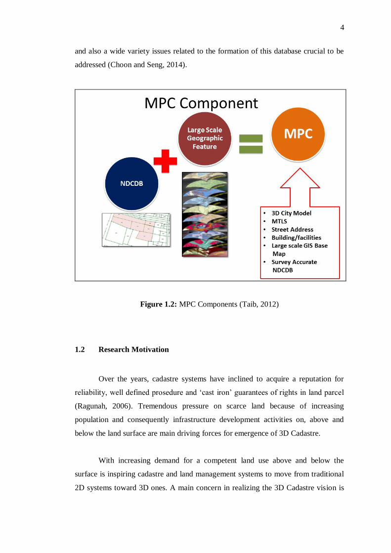
4
and also a wide variety issues related to the formation of this database crucial to be
addressed (Choon and Seng, 2014).
Figure 1.2: MPC Components (Taib, 2012)
1.2 Research Motivation
Over the years, cadastre systems have inclined to acquire a reputation for
reliability, well defined prosedure and ‘cast iron’ guarantees of rights in land parcel
(Ragunah, 2006). Tremendous pressure on scarce land because of increasing
population and consequently infrastructure development activities on, above and
below the land surface are main driving forces for emergence of 3D Cadastre.
With increasing demand for a competent land use above and below the
surface is inspiring cadastre and land management systems to move from traditional
2D systems toward 3D ones. A main concern in realizing the 3D Cadastre vision is

5
the development of competent approaches for the attachment of the 3D to the
existing 2D systems (Filin et al., 2005).
According to the report of Cadastre 2014, feature cadastres will show the
complete legal situations of land, including public rights and restrictions (Kaufmann
and Steudler, 1998). All these rights, restrictions and responsibilities related to land
are often overlapping, therefore, current 2D cadastre systems have revealed
limitations in certain 3D circumstances (Doner and Biyik, 2007). From the
perspective of scientific and technological, the principal challenge in developing a
3D Cadastre lies in collecting, processing and managing the 3D data.
One of the main principles of the development of cadastre system is the fully
3D land parcel information surface. Previous study that has been executed by Stoter
and Gorte (2003), to integrate of 2D data and elevation information in cadastre land
parcel. Moreover, Doner and Biyik (2007) stated that, in 3D Cadastre, surface
models are used to generate elevation surfaces of cadastre land parcels.
Nowadays, with the recent technologies in surveying such as active remote
sensing and Global Positioning System (GPS) enable to be collected the 3D data
with high accuracy. Although it is possible to collect 3D data by means of several
techniques, it entails huge amount of time and budget to resurvey all the data which
is already available today (Doner and Biyik, 2007). In terms of the observational
time is too lengthy, making it a slow, labour-intensive, painstaking and costly
operation, resurveying of 2D parcels may not be practical to locate them in 3D space
and elevation information.
Currently with the emerge of advanced aerial mapping techniques such as
Airborne Light Detection and Ranging (LiDAR) and Interferometric Synthetic
Aperture Radar (IFSAR) data are now widely used for a number of applications,
notably those requiring a Digital Terrain Model (DTM). Thus, it can be more
appropriate to integrate LiDAR or IFSAR data to the current 2D data. Filin et al.,
(2005), Souza and Amorim, (2012) and Morska et al.,( 2013) have performed
previous study on airborne laser technology like LiDAR to 3D Cadastre. In this

6
regard LiDAR that offers direct acquisition of dense and accurate 3D data for
integrating airborne laser scanning data and existing 2D cadastre system.
The primary motivation of this research is to explore and examine a
feasibility development of 3D NDCDB with several data sources. The addition
elevation data into cadastre boundary marks (CBMs) in the NDCDB would produce
a 3D NDCDB. The 3D NDCDB is a mixture of the land parcel boundary and
elevation information into cadastre boundary marks in order to acquire a parcel
surface and it can be integrated with 3D objects like tunnel, cables, pipelines and etc.
Moreover, this can be one way of the solutions to determine parcels in 3D space with
integration of 2D Cadastre data and elevation information.
1.3 Problem Statement
DSMM has initiated the modernization programme of the cadastre survey
system in stages in line with the advancement of current technologies. eCadastre is
the latest venture in empowering the digital cadastre database of DSMM in order to
accelerate the delivery system for land title surveys. It is implemented with new fully
GIS-ready database, namely the NDCDB. At present, NDCDB is contains 40 million
CBMs based on Geocentric Datum of Malaysia 2000 (GDM 2000) for Peninsular
Malaysia and Federal Territories of Malaysia (Taib, 2012). Recently, NDCDB is
adopted a database of two-dimensional, where the information is stored in two-
dimensional planimetric coordinate (North (N), East (E)) without vertical
information (Height (H)). However, in the future, 2D information may no longer
capable to serve the community owing to the high demands for enriching
information from the NDCDB, notably in more complex high-density developments
in urban areas.
According to Hassan et al. (2008), an increasing requirement in using space
on, above or below the ground surface for constructions of real objects notably in big
cities areas (Hassan et al., 2008). The mission of Cadastre 2014 as recommended by
the FIG Commission 7, stated that in the future the cadastre system must not depend
7
on 2D mapping (Choon and Seng, 2013). Enhancement of existing NDCDB is
required to suit the current circumstances. One way to deal with this situation is by
having more 2D Cadastre database which include the 3D information about land
information to NDCDB by using a wide variety of data sources. This research is
carried out to create height information to 2D land parcels and generate the terrain
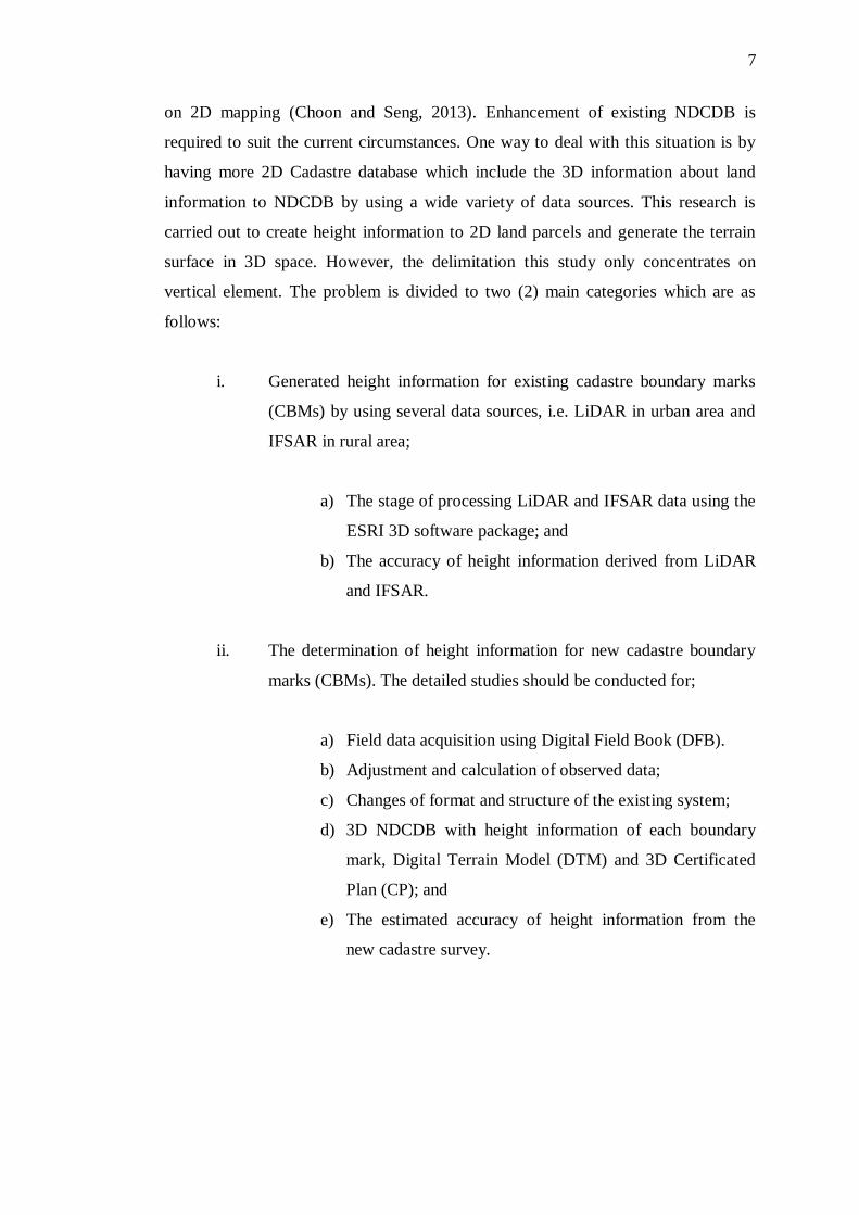
surface in 3D space. However, the delimitation this study only concentrates on
vertical element. The problem is divided to two (2) main categories which are as
follows:
i. Generated height information for existing cadastre boundary marks
(CBMs) by using several data sources, i.e. LiDAR in urban area and
IFSAR in rural area;
a) The stage of processing LiDAR and IFSAR data using the
ESRI 3D software package; and
b) The accuracy of height information derived from LiDAR
and IFSAR.
ii. The determination of height information for new cadastre boundary
marks (CBMs). The detailed studies should be conducted for;
a) Field data acquisition using Digital Field Book (DFB).
b) Adjustment and calculation of observed data;
c) Changes of format and structure of the existing system;
d) 3D NDCDB with height information of each boundary
mark, Digital Terrain Model (DTM) and 3D Certificated
Plan (CP); and
e) The estimated accuracy of height information from the
new cadastre survey.

8
1.4 Research Objective
The aim of this study is to investigate feasibilities development of the 3D
NDCDB with various data sources and assessment the quality of the generated
elevation.
The specific objectives of this research include:
i. To investigate and to examine the feasibility of developing the 3D
NDCDB;
ii. To develop a new method for generating height information in
cadastre survey; and
iii. To evaluate the accuracy of height information generated from
LiDAR, IFSAR and a new cadastre survey.
1.5 Significance of Research
One of the vital principles in the development of a 3D Cadastre system is to
provide land with elevation data. Combination of elevation information and 2D land
parcel enables to locate the cadastre land parcel in 3D space. Currently, NDCDB is
two-dimensional in nature. As mentioned earlier, it does not contain elevation
information within the land parcel area. Solution towards 3D Cadastre is to study
possible solutions in adding a 3D component (N, E, H) in the current situation. This
enhancement will be used as a platform to suit with the Malaysian Cadastre System.
For the future, the NDCDB is capable of storing, visualizing and manipulating
accurate legal records of 3D data.
Elevation information contributes to inform decision making and impact a
wide range of vital activities including mapping and charting, flood risk
determination, transportation, flood mitigation, land use and others. The 3D NDCDB

9
is a paradigm shift for modern cadastre system and a step towards the MPC concept.
It is not only enhancing the government frameworks but also providing more
realistic and useful information for all levels generally (Ajibah, 2014).
The need for height information for approaching urban problems has grown
rapidly. The requirements comprise design and inspection of utilities such as water
mains, tunnels, sewer systems, bridges, railroads, roads and power lines and also for
city planning and development purposes (Mathias, 2001). In the past, the
determination of height information would usually suffice with contour lines.
Currently, the demands with respect to accuracy are far beyond this point. The latest
remote sensing methods have emerged which are capable to react to these demands.
This situation shall trigger a good basis for the integration of height information
from the remote sensing data and 2D cadastre data.
The significances of this study include:
i. Enhancing NDCDB;
ii. The elevation of land surface is used for computation of land
area and volume more efficiently;
iii. Guideline to authorities to form a strategy toward 3D NDCDB;
iv. The height information derived can expand the application of
NDCDB especially for urban area; and
v. In line with recent technology development, such as
Multipurpose Cadastre, Cadastre 2014 and Spatially Enable
Government.

10
1.6 Organization of Thesis
In this research, there are total of five (5) chapters, each overview plays a
vital part in describing the development of 3D NDCDB. The description of each
chapter has designated as follows:
Chapter 1 provides a general overview of the research. It contains the
description of the background study and clarify the general idea of this study. This
chapter comprises background of study, research motivation, problem statement,
aims and research objectives, research question and significance of this research.
Chapter 2 reviews the literature on the basic understanding of the research
before conducting the study. In this chapter, explanation an overview on cadastre,
3D Cadastre, Malaysian Cadastre System, height reference system, height
determination techniques, remote sensing technologies and 3D surface model. In a
literature review, materials that are relevant to the research are obtained from various
sources and have been used as a reference to enhance understanding of the theories
in order to complete this study.
Chapter 3 introduces the flow of work of this study and it is shown in the
form of flow chart. This chapter will involves technical processes to create the 3D
NDCDB. All techniques used are discussed in this chapter. In performing these
processes the researcher has to use ESRI’s 3D software package. There are five (5)
main processes in the methodology, which are data acquisition, data processing, data
analysis, data validation and result and analysis.
Chapter 4 shows the results obtained from this study. This chapter discusses
on accuracy assessment of each result for LiDAR, IFSAR data and new cadastre
survey. Meanwhile, defines the analysis in the form of graphical presentation.
Finally, the results will be analyzed and been discussed.
Chapter 5 concludes the finding of this study. Recommendations are given to
discuss the different point of view might be useful for further development of the
study.

128
REFERENCES
Abu, S. (2005a). Geocentric Datum of Malaysia 2000 (GDM2000) and CCS
Infrastructure. In Seminar and Bengkel Coordinated Cadastral System (CCS)
Melaka 26 – 27 Julai 2005.
Abu, S. (2005b). JUPEM Geodetic Infrastructure for GNSS Application. Geodesy
Section Mapping Division, DSMM.
Acharya, B. R. (2011). Prospects of 3D Cadastre in Nepal Prospects of 3D Cadastre
in Nepal. In 2nd International Workshop on 3D Cadastre, 16-18 November
2011, Delft, The Netherlands (pp. 241–254).
Aguilar, F. J., Mills, J. P., Delgado, J., Aguilar, M. a., Negreiros, J. G., and Pérez, J.
L. (2010). Modelling Vertical Error in LiDAR-Derived Digital Elevation
Models. ISPRS Journal of Photogrammetry and Remote Sensing, 65(1), 103–
110.
Aien A. et al. (2012). Developing and Testing a 3D Cadastral Data Modela Case
Study In Australia. ISPRS Annals of the Photogrammetry, Remote Sensing and
Spatial Information Sciences, Volume I-4, 2012 XXII ISPRS Congress, 25
August – 01 September 2012, Melbourne, Australia.
Ajibah. (2014). The Implementation of 3D Coordinates into Land Parcel Data can
Solve some Complications of 3D Property Situations. Msc. Thesis UTM.
Ali, H., Nordin, A. F., Abu, S., and Hua, C. L. (2006). MyRTKnet: Get set and go !
Coordinates, II(6), 6–13.
Altamimi, Z., Boucher, C., and Sillard, P. (2002). New Trends for the Realization of
the International Terrestrial Feference System. Advances in Space Research, 30
(2), 175–184.

129
Ayeni. B and Kayode J.S (2014). An Evaluation of Digital Elevation Modeling in
GIS and Cartography. Geo-spatial Information Science. Vol. 17, No. 2, 139–
144
Colin Childs (2004). Interpolating in ArcGIS Spatial Analyst. ArcUser July-
September 2004.
Arun P.V. (2013). A Comparative Analysis of Dfferent DEM Interpolation Methods.
The Egyptian Journal of Remote Sensing and Space Sciences (2013) 16, 133–
139.
Ave, H. (2000). Basic Surveying - Theory And Practice (pp. 1–162). Bend, Oregon.
Azman. (2014). Penolong Pengarah Ukur. Seksyen Pengurusan Maklumat dan
Pembangunan Sistem, Bahagian Pangkalan Data Geospatial Negara. Jabatan
Ukur dan Pemetaan Malaysia.
Benhamu, M., & Doytsher, Y. (2001). Research Toward A Multilayer 3-D Cadastre :
Interim Results. In Proceedings of International Workshop on 3D Cadastres,
Registration of Properties in Strata, Delft, The Netherlands, November 2001.
Benhamu, M., & Doytsher, Y. (2003). Toward a Spatial 3D Cadastre in Israel.
Computers, Environment and Urban Systems, 27(4), 359–374.
Caulfield, B. (2014). Total Stations. Belfield Dublin 4: University College Dublin.
Retrieved from ttp://www.tcd.ie/civileng/Staff/Brian.Caulfield
Ceylan, A., Inal, C., and Sanlioglu, I. (2005). Modern Height Determination
Techniques and Comparison of Accuracies Mo. In FIG Working Week 2005
and GSDI-8, Cairo Egypt, 16-21 April 2005 (pp. 1–14).
Che Cob, A. S., Mat Yasin, A. T., and Adimin, M. K. (2011). Application Of Ifsar
Technology In Topographic Mapping: JUPEM’s Experience. In 11th South
East Asian Survey Congress and 13th International Surveyors’ Congress
Innovation towards Sustainability (pp. 1–8).
Choon, T. L., and Seng, L. K. (2013). Towards a Malaysian Multipurpose 3D
Cadastre based on the Land Administration Domain Model (LADM) – An
Empirical Study. In 5th Land Administration Domain Model Workshop, 24-24
September 2013, Kuala Lumpur Malaysia (pp. 109–132).
130
Choon, T. L., and Seng, L. K. (2014). Developing Infrastructure Framework for 3D
Cadastre. In FIG Congress 2014, Engaging the Challenges- Enhancing the
Relevance, 16-21 June 2014, Kuala Lumpur, Malaysia (pp. 1–13).
Cunningham, K. W. (2007). The Use of Lidar for Change Detection and Updating of
the CAMA Database. Journal of Property Tax Assessment and Administration,
4(3), 5–12.
Davis, P. A., Mietz, S. N., Kohl, K. A., Rosiek, M. R., and Gonzales, F. M. (2002).
Evaluation Of Lidar And Photogrammetry for Monitoring Volume Changes In
Riparian Resources Within The Grand Canyon, Arizona. In Pecora 15/ Land
Satellite Information IV/ISPRS Commission I/FIEOS 2002 (Vol. C, pp. 1–5).
Doner, F., and Biyik, C. (2007). Defining 2D Parcels in 3D Space by Using
Elevation Data. In Strategic Integration of Surveying Services, FIG Working
Week 2007, Hog Kong SAR, China, 13-17 May 2007 (pp. 13–17).
Dong, H. J. et al. (2012). Initial Design of an LADM-based 3D Cadastre –Case
Study from Korea.3rd International Workshop on 3D Cadastres: Developments
and Practices, 25-26 October 2012, Shenzhen, China.
Dowman, I. (2004). Integration of LiDAR And IFSAR for Mapping. In ISPRS
Proceedings, XXXV Congress (pp. 1–12). ISPRS.
DSMM. (2005a). Director General Survey and Mapping Secular 10/2005. KPUP
Circular 10/2005, 148(September), 1–17.
DSMM. (2005b). Director General Survey and Mapping Secular 9/2005. KPUP
Circular 9/2005, 148(September), 1–18.
DSMM. (2009a). Director General Survey and Mapping Secular 5/2009. KPUP
Circular 5/2009, 148(Julai).
DSMM. (2009b). Director General Survey and Mapping Secular 6/2009. KPUP
Circular 6/2009, 148(Disember).
DSMM. (2012). Status of Surveying and Mapping in Malaysia. In Nineteenth United
Nations Regional Cartographic Conference for Asia and the Pacific Bangkok,
29 October-1 November 2012 (Vol. 6, pp. 1–13). United Nation.
Featherstone, W. E., and Kuhn, M. (2006). Height Systems and Vertical Datums: A
Review in the Australian context. Journal of Spatial Science, 51(1), 21–41.
FIG. (1995). Statement on the Cadastre. Retrieved from https://www.fig.net
/commission7 /reports/cadastre/ statement on cadastre.html

131
Filin, S., Kulakov, Y., and C Doytsher, Y. (2005). Application of Airborne Laser
Technology to 3D Cadastre. In FIG Working Week 2005 and GSDI-8, Cairo,
Egypt 16-21 April 2005 (pp. 1–13).
Fraczek, W. (2003). Mean Sea Level, GPS and the Geoid. ArcUser, 36–41.
Retrieved from www.esri.com
Gary, J. H., and Ian, P. W. (1990). The Development of a Historical Digital
Cadastral Database. Int. J. Geographical Information Systems, Vol.4(2), 169–
179.
Giannaka, O., Dimopoulou, E., and Georgopoulos, A. (2014). Investigation on the
Contribution of LiDAR data in 3D Cadastre. In Second International
Conference on Remote Sensing and Geoinformation of the Environment
(RSCy2004) (Vol. 9229, pp. 1–11).
Gomes Pereira, L. ., and Janssen, L. L. . (1999). Suitability of Laser Data for DTM
Generation: A Case Study In The Context of Road Planning and Design. ISPRS
Journal of Photogrammetry and Remote Sensing, 54(4), 244–253.
Hassan, M., Yaakop, I. A., Ahmad Nasruddin, M. ., and Abdul Rahman, A. (2008).
An Integrated 3-D Cadastre – Malaysia as an Example. The International
Archives of the Photogrammetry, Remote Sensing and Spatial Information
Sciences, Vol. XXXVI, 121–126.
Hazri.H. (2016). Pengarah Ukur Seksyen Kawalan Kualiti, Bahagian Pangkalan Data
Geospatial Negara. Jabatan Ukur dan Pemetaan Malaysia.
Higgins, M. B. (1999). Heighting with GPS: Possibilities and Limitations. In
Commission 5 of the International Federation of Surveyors (FIG) (pp. 1–10).
Hodgson, M. E., and Bresnahan, P. (2004). Accuracy of Airborne Lidar-Derived
Elevation: Empirical Assessment and Error Budget. Photogrammetric
Engineering & Remote Sensing, 70(3), 331–339.
Höfle, B., and Rutzinger, M. (2011). Topographic Airborne LiDAR in
Geomorphology: A Technological Perspective. Zeitschrift Für
Geomorphologie, Supplementary Issues, 55(2), 1–29.
Hsia, J.-S., and Newton, I. (1999). A Method for the Automated Production of
Digital Terrain Models Using a Combination of Feature Points , Grid Points ,

132
and Filling Back Points. Photogrammetric Engineering & Remote Sensing,
65(6), 713–719.
Jamil, H. (2011). GNSS Heighting and Its Potential Use in Malaysia GNSS
Heighting and Its Potential Use in Malaysia. In FIG Working Week 2011,
Bridging the Gap between Cultures, Marrakech Morocco, 18-22 May 2011 (pp.
1–19).
Jamil, H., Mohamed, A., and Chang, D. (2010). The Malaysia Real-Time Kinematic
GNSS Network (MyRTKnet) in 2010 and Beyond. In FIG Congress 2010,
Facing the Challenges, 11-16 April 2010, Sydney, Australia (pp. 1–15).
Jamil, H., Yunus, M., and Zurairah, N. (2014). Implementing Multipurpose Cadastre
in Malaysia. Coordinates Jun 2014, X(06), 24–28.
Jedlika, K. (2009). Accuracy of Surface Models Acquired from Different Sources —
Important Information for Geomorphological Research. Geomorphologia
Slovaca Et Bohemica, 17–28.
Kaufmann, J., and Steudler, D. (1998). A Vision For A Future. Working Group 1 of
FIG Commission 7, (July), 1–44.
Kenduiywo, B. K., Odera, P. A., and Hunja, E. (2013). Orthometric Height
Determination using GPS to Fast Track Development : a Case study of Nairobi
County, Kenya. In Proceedings of Global Geospatial Conference 2013 (pp. 1–
11), Ethiopia.
Kuzevicova et al. (2014). Spatial Interpolation and Calculation of the Volume an
Irregular Solid. International Journal of Engineering and Applied Sciences.
(Vol.4 pp. 14-21).
Lemmen, C., and Van Oosterom, P. (2003). 3D Cadastres. Computers, Environment
and Urban Systems, 27(4), 337–343.
Letourneau, F. (1998). Different Approaches for the Creation and Exploitation of 3D
Urban Models (Vol. 5, pp. 1–15).
Li, X., Baker, A. B., and Thomas Hutt. (2002). Accuracy of Airborne IFSAR
Mapping. In FIG/ASPRS (pp. 1–11). Ontario, Canada: Intermap Technologies
Corp.
LLiu, X. (2011). Accuracy Assessment of LiDAR Elevation Data using Survey
Marks. Commonwealth Reporting Category C, 1–14.

133
Lohmann, P., Koch, A., and Schaeffer, M. (2000). Approaches to the Filtering of
Laser Scanner Data. In International Archives of Photogrammetry and Remote
Sensing (Vol. XXXIII, pp. 540–547).
Majid, A. D. (1997). Cadastral Reforms In Malaysia. Retrieved from
https://www.fig.net/commission7/ reports/ events/penang97/ penang973.htm
Mohamed, A. (2003). An Investigation Of The Vertical Control Network Of
Peninsular Malaysia Using A Combination Of Levelling, Gravity, GPS And
Tidal Data. Phd. Thesis, UTM.
Mathias J.P.M. Lemmens. (2001). Height Information from Laser-Altimetry for
Urban Areas. In Map India 2001, New Dehli, 7-9 February, pp. 131-135.
Morska, A., Sanecki, J., Klewski, A., Beczkowski, K., Pokonieczny, K., & Stępień,
G. (2013). Zeszyty Naukowe The usage of DEM to create the 3D cadastre.
Scientific Journals, 33(105), 86–90.
Nestorović, Ž., and Delčev, S. (2015). Comparison of Height Differences obtained
by Trigonometric and Spirit Leveling Method. Geonauka, 02(04), 30–37.
Nidal, A. D., and Yangdong, W. (2002). Geospatial Solutions - Active Sensors and
Modern Photogrammetry. Retrieved from http:// www.geospatial-online.com
/geospatialsolutions.
NOAA. (2012). Lidar 101: An Introduction to Lidar Technology , Data and
Applications. NOAA Coastal Services Center (pp. 1–76).
Nordin, A. F. (2003). Institutional Issues On The Implementation Of The
Coordinated Cadastral System For Peninsular Malaysia: A Study On The Legal
And Organisational Aspects. Msc. Thesis UTM.
Omar, A. H. (2004). Development of A Coordinated Cadastral System for
Peninsular Malaysia. Phd. Thesis. Universiti Teknologi Malaysia.
Omar, A. H., Kadir, A. M. A., and Shah, R. M. (2006). Development of Automated
Cadastral Database Selection and Visualization System to Support the
Realization of Modern Cadastre In Malaysia (Vol. IRPA VOTE, pp. 1–142).
FKSG, UTM.
Palmer, T. C., and Shan, J. (2002). A Comparative Study on Urban Visualization
using LIDAR Data in GIS. URISA Journal, Vol. 14(No. 2), 19–25.
134
Panel on a Multipurpose Cadastre. (1980). Need for a Multipurpose Cadastre.
Committee on Geodesy, Assembly of Mathematical and Physical Sciences,
National Research Council. National Academic Press. Washington.
Peng, M., and Shih, T. (2006). Error Assessment in Two Lidar-derived TIN
Datasets. Photogrammetric Engineering & Remote Sensing, Vol. 72(August),
933–947.
Pourali, S., Arrowsmith, C., and Chrisman, N. (2014). Vertical Accuracy
Assessment of LiDAR Ground Points using Minimum Distance Approach. In
Research@Locate 14, Canberra Australia, 7-9 April 2014 (pp. 86–96).
Radhie, M. (2014). Accuracy Assessment of LiDAR Derived Digital Elevation
(DEM) with Different Slope and Different Canopy Density. Bsc. University
Technology Malaysia.
Ragunah, M. (2006). Application of Remote Sensing and GIS in Urban Land
Suitability Modeling at Parcel Level using Multi-criteria Decision Analysis.
The Andhra University, Visakhapatnam.
Schenk, T. (2005). Introduction to Photogrammetry (No. 2070 Neil Ave, Columbus)
(pp. 1–100).
Seng Chai, C. (2006). Towards a 3D Cadastre in Malaysia- An Implementation
Evaluation. Delf University of Technology, Netherlands.
Setan, H., and Othman, R. (2006). Monitoring of Offshore Platform Subsidence
Using Permanent GPS Stations. Journal of Global Positioning Systems, 5(1),
17–21.
Shamsul Abdul Majid. (2000). Benefits and Issues of Developing a Multi-Purpose
Cadastre. In International Archives of Photogrammetry and Remote Sensing.
Vol. XXXIII, Supplement B4, Amsterdam 2000 (Vol. XXXIII, pp. 15–22).
Sim, C. Y. (2012). Investigation of Data Models and Related Requirements Affecting
The Implementation of a Multipurpose Cadastre System in Malaysia.
Msc.Thesis. University of Glasgow.
Souza, G. H. B., and Amorim, A. (2012). LiDAR Data Integration for 3D Cadastre:
Some experiences from Brazil. In FIG Working Week, Knowing to Manage the
Territory, Protect the Environment, Evaluate the Cultural Heritage, Rome Italy,
6-10 May 2012 (pp. 6–10). International Federation of Surveyors.
135
Stoter, J.E., and Gorte, B., (2003), Height in the Cadastre: Integrating Point Heights
and Parcel Boundaries, In Proceedings of the FIG Working Week 2003, April
13-17, Paris, France.
Stoter, J. E. (2004). 3D Cadastre (No. ISBN 90 6132 286 3) (pp. 1–342). Delft,
Netherlands.
Stoter, J. E., and Ploeger, H. D. (2003). Registration of 3D Objects Crossing Parcel
Boundaries. In FIG Working Week 2003, Paris, France, 13-17 April 2003 (pp.
1–16).
Stoter, J., and Gorte, B. (2003). Height in the Cadastre Integrating Point Heights and
Parcel Boundaries. In FIG Working Weeks 2003, Paris, France, 13-17 April
2003 (pp. 1–12).
Sulaiman, N. S., Majid, Z., and Setan, H. (2010). DTM Generation From LiDAR
Data by using Different Filters In Open – Source Software. Journal,
Geoinformation Science, 10(2), 89–109.
Taib, A. K. (2010). Initiatives Toward Digital Malaysia. In National Geospatial
Information Symposium (p. 59). DSMM.
Taib, A. K. (2012). Developing a Multi-purpose Cadastre in Malaysia. In Malaysia
Geospatial Forum 2012, Melaka, 6-7 March 2012 (pp. 1–29).
Teng, C. H. (2009). DCDB 2 NDCDB. In In: International Federation of Surveyors
ed. 2009 FIG Commission 7 Annual Meeting. Kuala Lumpur, Malaysia:
International Federation of Surveyors. (pp. 1–106).
Tomaž, P., Stancic, Z., and Oštir, K. (2000). Data Integration For The DTM
Production. In ISPRS WG VI/3 and IV/3 meeting: Bridging the Gap, Ljubljana,
2-5 February 2000 (pp. 1–7).
Wang, Y., Mercer, B., Tao, V. C., Sharma, J., Crawford, S., and Corporation, I. T.
(2001). Automatic Generation of Bald Earth Digital Elevation Models from
Digital Surface Models Created using Airborne IFSAR. ISPRS 2001 (pp. 1–11).
Wei, M., and Coyne, T. (2008). Integrated Airborne IFSAR Mapping System. In The
International Archives of the Photogrammetry, Remote Sensing and Spatial
Information Sciences, Beijing 2008 (Vol. Vol. XXXVI, pp. 367–372).
Williamson, I. P. (2001). The Evolution of Modern Cadastres (pp. 1–14). Retrieved
from www.geom.unimelb.edu.au/research/SDI_research
136
Xiaopeng Li et al. (2002). Accuracy of Airborne IFSAR Mapping. Intermap
Technologies Corp. Nepean, Ontario, Canada.
Yunus, M., Yusoff, M., and Abdul Halim, Z. N. (2012). Unleashing the Full
Potential of eKadaster on The Cadastral System of Malaysia. In Nineteenth
United Nations Regional Cartographic Conference for Asia and the Pacific
Bangkok, 29 October-1 November 2012 (pp. 1–11).
Yunus, M., Yusoff, M., Jamil, H., Zurairah, N., and Halim, A. (2013). eKadaster : A
Learning Experience for Malaysia Ekadaster : A Learning Experience for
Malaysia. In FIG Pacific Small Island Developing States Symposium, Suva, Fiji
18-20 September 2013 (pp. 18–20).
Zhenglu, Z., Kun, Z., Yong, D., and Changlin, L. (2005). Research On Precise
Trigonometric Leveling In Place of First Order Leveling. Geo-Spatial
Information Science, 8(4), 235–239.
Zhou, X. P., and Sun, M. (2013). Study on Accuracy Measure of Trigonometric
Leveling. Applied Mechanics and Materials, 329, 373–377.
Zulkifli, N. A., Rahman, A. A., and Oosterom, P. Van. (2013). Developing 2D and
3D Cadastral Registration System based on LADM: illustrated with Malaysian
Cases. In 5th Land Administration Domain Model Workshop, 24-24 September
2013, Kuala Lumpur Malaysia (pp. 447–464).