january 2020 - microsoft... · wellbeing strategy. bedford borough health and wellbeing strategy...
TRANSCRIPT

Bedford Borough Local Plan 2030
Adopted version (this document contains the final text which will be typeset in due course)
January 2020

(This page is intentionally blank)

Contents
Chapter
Page
1 Introduction
2 Spatial portrait
3 Vision
4 Objectives
5 Health
6 Strategy
7 Allocations
8 Place making
9 Resources and climate change
10 Housing
11 Economy
12 Plan implementation and infrastructure delivery
13 Monitoring
Appendix 1 Status of development plan policies
Appendix 2 List of strategic policies
Appendix 3 List of all local plan policies
Appendix 4 Affordable housing commuted sum calculation
Appendix 5
Appendix 6
Appendix 7
Glossary
Local Green Spaces
Housing Opportunity Sites

1.0 Introduction
1.1 The purpose of the Local Plan 2030 is to plan for Bedford borough’s growth needs to 2030. Currently the Council’s development plan is
made up of several different documents adopted at different times and covering the plan period to 2021. Those documents are:
Local Plan 2002 (saved policies)
Core Strategy and Rural Issues Plan 2008
Bedford Town Centre Area Action Plan 2008
Allocations and Designations Local Plan 2013
Minerals and Waste Local Plan: Strategic Sites and Policies, 2014
1.2 Most of the policies in the Allocations & Designations Local Plan are still relevant and so will not be replaced in this plan. However the
preparation of the Local Plan 2030 is an opportunity to replace most of the policies in the remaining documents.
1.3 Appendix 1 explains how policies in this plan will affect the status of current development plan policies. Policies that are no longer
needed are also identified, along with reasons for their deletion.
Structure of this document
1.4 Overarching and strategic matters are covered first. These are followed by site allocations and then development management policies.
Later chapters deal with infrastructure requirements and monitoring arrangements. Policies are simply numbered consecutively.
Strategic policies have the suffix ‘S’. Strategic Policies are listed in Appendix 2. Appendix 3 lists all local plan policies.
The evidence base
1.5 The preparation of this local plan is reliant on a robust evidence base. Responses to consultations that have been undertaken during the
issues and options stage of plan preparation have also shaped the Plan. Details of those consultations are found on the Council’s web
site www.bedford.gov.uk/localplan2030

Sustainability appraisal
1.6 A key element of the planning system is the requirement to undertake sustainability appraisal. This is to ensure that the local plan is
compatible with the aims of sustainable development. Sustainability appraisal is carried out as the local plan is prepared and involves
assessing strategic alternatives and policies against social, economic and environmental objectives. Where necessary the plan is
modified in response to the results to ensure that harmful impacts are avoided or mitigated. A sustainability appraisal report setting out
the Council’s work has been published alongside this document.
The National Planning Policy Framework (NPPF)
1.7 The revised NPPF was published just before the Local Plan 2030. The revised NPPF provides transitional arrangements for plans in
their latter stages of preparation and this means the Local Plan 2030 will be examined against the 2012 NPPF. For this reason,
references within the local plan are to the 2012 NPPF.
Reviewing Local Plan 2030
1.8 Due to the changes to national planning policy, in particular the need for the borough to plan for higher housing numbers beyond this
local plan, the Council will undertake an early review of the local plan once adopted. Significant infrastructure proposals such as the
A428 road link between the Black Cat roundabout on the A1 and Caxton Gibbet, the redesign and reconstruction of the A421/A1 junction
itself, the A421 expressway, East/West rail link and potential A1 north/south realignment between the A1/A14 intersection and south of
Biggleswade will bring very significant change and potentially new and better connected development opportunities both within and
beyond the borough.
1.9 The government is currently exploring prospects for strategic growth within the Oxford-Cambridge Arc. The local plan review will provide
the opportunity to reflect those decisions with future housing and employment growth aligned with infrastructure delivery timetables.
Working with nearby authorities either through the duty to cooperate or jointly on cross boundary strategic plans the Council will seek to
deliver sustainable solutions to the challenge of increasing housing delivery.
1.10 The local plan review may also provide the opportunity for the Council to make site allocations in the rural part of the borough if
neighbourhood plans have failed to deliver them in the timescale anticipated (see Policy 4S).

Policy 1 Reviewing the Local Plan 2030
The Council will undertake a review of the Local Plan 2030, which will commence no later than one year after the adoption of the plan. An
updated or replacement plan will be submitted for examination no later than three years after the date of adoption of the plan. In the event that
this submission date is not adhered to, the policies in the Local Plan 2030 which are most important for determining planning applications for
new dwellings will be deemed to be ‘out of date’ in accordance with paragraph 11 d) of the National Planning Policy Framework 2019.
The plan review will secure levels of growth that accord with government policy and any growth deals that have been agreed. The planning
and delivery of strategic growth will be aligned with the delivery of planned infrastructure schemes including the A421 expressway, Black Cat
junction, East West Rail link and potentially the A1 realignment.
The review will also serve to build stronger working relationships with adjoining and nearby authorities and may result in the preparation of a
joint strategic plan based on a wider geography.
Other plans and strategies
1.11 The Local Plan 2030 will align closely with other plans and strategies prepared by the Council and its partners. Key documents are listed
below.
Sustainable Community Strategy 2009 – 2021:
1.12 The Sustainable Community Strategy was produced in 2009 by the Bedford Borough Partnership. Whilst the deregulation Act 2015
removed the duty for local authorities to prepare a Sustainable Community Strategy, the existing Strategy still sets the overall strategic
direction and vision for promoting and improving the economic, social and environmental well-being of the borough. Its preparation was
overseen by the Partnership Board which brought together representatives from Bedford Borough Council, the Police, NHS
Bedfordshire, parish and town councils, schools, voluntary organisations, business and community groups. Those representatives no
longer meet under the umbrella of the Partnership Board but continue to work jointly on a range of strategic and local issues.
1.13 The Strategy sets out the Partnership's vision for the future of Bedford borough and the goals that the Partnership was seeking to
achieve. In a series of aims, it explains what the Partnership planned to do to meet those goals. The goals and aims are still relevant
today; many have direct links to the Local Plan 2030 and can be delivered by the local plan’s policies.

Bedford Borough the Place to Grow: Bedford Borough Corporate Plan 2017-2021
1.14 The Corporate Plan is part of the Council’s adopted Policy Framework and articulates our contribution to the delivery of the Sustainable
Community Strategy.
1.15 The Council’s ambition is that Bedford borough should be a place to grow and the Corporate Plan sets out how the Council will achieve
that. Four goals guide the Council’s approach, each focussed on enhancing Bedford borough as a place where people, communities and
businesses can grow and realise their potential. The Plan recognises that getting this right will require distinctive Council services
tailored to the needs of local people and businesses, but that these must be delivered alongside the things that every local council has to
do. What is different is that we will minimise the time and resources spent on activities that others could do better or for less than us, or
where the activity is no longer needed, so that we can focus on our priorities and shape the future of a thriving borough.
1.16 In order to build a Council fit for purpose both for today and tomorrow, alongside the delivery of the Corporate Plan the Council is
engaged in a transformation programme (Bedford 2020) to change how it works and engages with customers, and to focus resources
where they are most needed. By being clear on its strategic direction, the Council aims to grow its capability to deliver programmes in
partnership with communities and partners, operating as one Council and cutting across organisational boundaries.
Bedford Borough Joint Strategic Needs Assessment
1.17 The Joint Strategic Needs Assessment is a process by which Bedford Borough Council and Clinical Commissioning Groups assess the
current and future health, care and wellbeing needs of the local community to inform decision making. It considers how needs vary for
people at different ages, and may be harder to meet for those in disadvantaged areas or vulnerable groups who experience inequalities,
such as people who find it difficult to access services. It also looks at the wider social, environmental and economic factors that impact
on health and wellbeing - such as access to green space, air quality, housing, community safety and employment.
1.18 Bedford Borough’s Assessment incorporates a Planning section within the Wider Determinants area. This section draws together
evidence of the links between health and planning and the actions explain how we need to work effectively with the Clinical
Commissioning Group and Public Health Colleagues in the preparation of the Local Plan 2030, and to consider how Health Impact
Assessments can help the process of plan making and decision taking.
1.19 The preparation of the Joint Strategic Needs Assessment is the responsibility of the Bedford Borough Health and Wellbeing Board. The
Board was set up in 2011 and has a statutory responsibility to improve integrated working between local health care, social care, public
health and other public service practitioners so that patients and service users experience more joined-up care, particularly when moving

between health and social care. The Health and Wellbeing Board is also responsible for leading locally on reducing health inequalities.
As well as the Joint Strategic Needs Assessment, the Health and Wellbeing Board is responsible for producing a joint Health and
Wellbeing Strategy.
Bedford Borough Health and Wellbeing Strategy 2018-2023
1.20 This strategy outlines the Council’s top priorities for improving the health and wellbeing of all people living in the borough. It reflects the
health and social care needs identified in the Joint Strategic Needs Assessment. The priorities in this strategy have been identified and
agreed in partnership by all the Health and Wellbeing Board member organisations.
1.21 The health of people in Bedford borough has improved over recent years: death rates from cancer, heart disease and stroke have fallen,
and there has been a decline in the number of adults who smoke, which is now lower than the national average. However, there is a
widening gap in life expectancy between the most and least deprived areas and there is still much room for improvement. The Health
and Wellbeing Strategy outlines the council’s priorities for improving the health and wellbeing of Bedford Borough residents, and to
reduce health inequalities. To achieve this, the strategy sets out a life course approach that is ensuring plans are targeted at critical
points through life. However, the health of residents and communities is also shaped by the conditions in which we live, the extent of our
social connections and whether there are stable and supportive work opportunities. These are the wider determinants of health, and to
promote efforts to tackling the wider determinants the strategy includes a priority which will promote strong, safe and healthy
communities. Planning policies and the wider planning system can ensure that considerate design of spaces and places can help to
promote good health; access to goods and services; and alleviate, or in some cases even prevent, poor health thereby having a positive
impact on reducing health inequalities.
Bedford Borough Growth Plan 2018-2022
1.22 The Council’s powers for economic development derive from the general power of competence contained in Section 1 of the Localism
Act 2011. The Growth Plan intends to support and encourage the right conditions to create sustainable private sector jobs and to
stimulate and deliver economic growth across Bedford Borough that enables everyone to fulfil their ambitions and aspirations by putting
in place a range of actions that will further support three key enablers, growing business, enhancing place and developing people.
1.23 This is the borough’s second Growth Plan and its priorities are to create the right conditions to support and grow Bedford’s existing
businesses and attract new investment to the borough. The plan will contribute to delivery of a modern integrated transport network,
through the Transporting Bedford 2020 agenda and England’s Economic Heartland programme while driving the development and
delivery of strategic housing sites as well as the continued regeneration of our town centre through the One Public Estate programme.

The plan will have a direct role to play through schools, youth and adult services and the Bedford Jobs Hub in the provision of
employment and skills related services, tailoring these more towards employability and demand-led skills. The Local Plan 2030 can
support these priorities in a number of ways including through the suite of policies that seeks to retain the best employment sites in the
borough, encourage the re-use of older employment land for uses that provide jobs and explain the context for new strategic
employment proposals that arise in a fast-changing employment market.
Bedford Borough Local Transport Plan 2021
1.24 Bedford borough’s current Local Transport Plan, LTP3, is the first to cover the unitary authority area. Earlier plans were prepared by the
former Bedfordshire County Council and addressed the transport needs and priorities for the county as a whole. LTP3 sets out the
borough’s long term transport strategy and is reviewed on a regular basis to ensure that it continues to reflect the Council’s transport
priorities. It was prepared with input from partners and stakeholders, who the Council will continue to involve in its further development
and in the delivery of LTP3’s Implementation Plan.
1.25 Within LTP3 lie eight supporting strategies. These cover active travel; freight; network management; parking; passenger transport; road
safety; sustainable modes of travel to school and transport asset management.
1.26 The Local Plan 2030 will take account of the priorities within the LTP3 and will, through its transport and other policies, seek to promote
and deliver sustainable travel solutions.
Forest of Marston Vale ‘Forest Plan’
1.27 The Council is a founding partner in the 40-year vision to create the Forest of Marston Vale across 61 square miles between Bedford and
Milton Keynes. Designated by Government in 1991, the Forest of Marston Vale is one of England’s 12 Community Forests, which
together form the country’s largest environmental regeneration initiative. The aim is to achieve environmentally-led regeneration – using
extensive tree planting to transform the landscape, so transforming perceptions of the area, and transforming social and economic
prospects.
1.28 The creation of the Forest of Marston Vale is guided by the ‘Forest Plan’, a non-statutory strategic framework prepared through extensive
consultation and endorsed by a wide range of stakeholders, including local communities and Government. Whilst they are non-statutory
documents, approved Forest Plans are provided national policy support, and are a material consideration used to inform the preparation
of statutory development plans and in determining planning applications for development within the Forest boundary.

The Government's 25 Year Environment Plan (A Green Future: Our 25 Year Plan to Improve the Environment)
1.29 The 25 Year Plan is the Government's commitment to embedding an environmental net gain principle in development, including housing
and infrastructure. This compliments the existing commitment to biodiversity net gain. The plan recognises the role the natural
environment has in underpinning wellbeing and prosperity.
Bedfordshire’s natural environment – its value to us all
1.30 This document is prepared by the Bedfordshire Local Nature Partnership. It highlights some of the successes achieved in protecting and
improving Bedfordshire’s natural environment but also flags continuing pressures and identifies areas where more work may be needed.
Local Nature Partnerships are a Government initiative to create strategic partnerships to drive positive change for the natural
environment, relating the natural environment and its value to social and economic outcomes.
1.31 The Bedfordshire Local Nature Partnership brings together a wide range of partners from the public, private and third sectors actively
engaged in protecting and enhancing Bedfordshire’s natural environment. The Partnership seeks to promote a greater understanding
and appreciation of the natural environment and the services it provides to people who live in, work in or visit the area. It was established
in 2013 and its main purpose is to connect people with nature to get the best outcome for everyone. Three main aims of the Partnership
are to protect and improve Bedfordshire’s natural environment; to grow Bedfordshire’s green economy and to reconnect Bedfordshire’s
people with nature.
1.32 The Partnership is a ‘duty to cooperate partner’ which means that it has been involved in the evolution of the Local Plan 2030 and its
policies from the start. Bedford Borough Council is represented on the partnership’s management steering group. Currently SEMLEP is
working with the government to identify emerging priorities for accelerating local economic distinctiveness and sector growth potential,
linked to the Oxford – Cambridge Arc.
South East Midlands Local Enterprise Partnership (SEMLEP) Economic Plan
1.33 The Partnership’s role is to unlock the full growth potential of the South East Midlands. It does this by bringing together partners from the
public, private, education and not-for-profit sectors to secure infrastructure investment, develop a skilled workforce that meets employers
needs and provide business growth advice and access to finance to support key sectors. The South East Midlands is a high growth
economy occupying a strategic location. The SEMLEP Economic Plan has seven priorities spread over the four themes of growing
business; growing people; growing places and cross-cutting. The Partnership has secured £265m of Local Growth Fund from
Government to support a portfolio of projects that unlock the growth potential of the area, and increase jobs, learner numbers,

employment floorspace and homes. Several projects are in Bedford borough and delivery will be supported by policies in the Local Plan
2030.
1.34 SEMLEP is represented on the board of the Bedfordshire Local Nature Partnership in recognition of the fact that to deliver its economic
ambitions the role of the natural environment needs to be understood and reflected in decision making. This relationship is explained
further in the joint publication ‘It’s the economy, naturally’. Activities such as attracting inward investment and retaining existing
businesses; underpinning the visitor economy; creating healthy and productive communities, managing environmental risks through
greening our businesses, and supporting skills in the green economy are identified as ways that the environment can support economic
growth.

2. Spatial portrait
A prime location; the place to grow
2.1 The borough of Bedford lies mid-way between the M1 and A1 about 30 miles north of the M25. This prime location means that about half
of the UK’s population is within a two hour drive. London is just over half an hour away by train and its five airports are within easy reach
from Bedford by car and public transport. Improving east west transport infrastructure means that the borough is enjoying increasingly
stronger links with centres in the Oxford to Cambridge Arc. Within the Golden Triangle (Figure 1), Bedford borough is already a great
location to live and do business and its future prospects are excellent.
Figure 1 Bedford borough’s strategic location

Our neighbours
2.2 Along with the other two Bedfordshire unitary authorities, Luton and Central Bedfordshire, Bedford borough has historically been on the
western edge of the East of England planning region. With the abolition of regional plans, the borough is now part of the wider south
east grouping of local authorities. Figure 2 below shows Bedford borough and those near neighbours that now make up the South East
Midlands Local Enterprise Partnership (SEMLEP). The SEMLEP area is experiencing significant pressure for growth because of its
favourable location close to London.
Figure 2 The South East Midlands Local Enterprise Partnership area
2.3 In terms of its housing market area the borough is fairly self-contained and as a result of allocations in earlier plans it offers a good range
of strategic employment opportunities. To date near neighbours have not called upon Bedford Borough Council to make provision for
growth beyond our own objectively assessed need. However we are part of the ongoing discussion between the wider south east
authorities about accommodating London’s future growth, and more generally about the advantages associated with planning on a
‘larger than local’ scale. The National Infrastructure Commission’s in depth investigation of the growth potential of the Oxford to
Cambridge Arc has and will continue to inform this discussion. Bedford Borough Council continues to engage positively with surrounding
authorities about meeting future growth needs.
Our local geography
2.4 About 168,000 people live in Bedford borough; two thirds in the main urban area of Bedford and Kempston and one third in the rural area
surrounding it. Bedford and Kempston have grown in recent years and the villages of Biddenham and Elstow now largely sit within an
urban context, though each retains its own distinctive character and sense of identity. Beyond the town some of the larger villages, such
as Clapham, Bromham, Wootton and Shortstown are very close to the urban edge whilst others including Great Barford, Wilstead and
Sharnbrook lie further from it. The borough also offers a patchwork of smaller villages and hamlets (or ‘Ends’ as they are known locally)
and together with the town and larger villages and the growing new settlement of Wixams they form a well-connected network of
settlements offering a wide choice of living environments for the borough’s residents.
Landscape and natural environment
2.5 Geologically the borough is dominated by elevated clay plateaux to the north of the town resulting in a very open and rural landscape
with pockets of Ancient Woodland and long views over rolling countryside. To the west is a distinctive limestone landscape created by
the River Great Ouse which meanders from Turvey in the north west to and beyond the county boundary east of Willington. By contrast,
south and west of the urban area the brick making industry has left land in need of restoration. In part this is being addressed through
development opportunities and the 40 year vision to create the Forest of Marston Vale to transform the area, which after 20 years in the
making has trebled woodland cover.
2.6 The pattern of settlement in the rural part of Bedford borough is a mixture of nucleation and dispersal. In the river valleys, Domesday
manors and their surrounding nucleated settlements tend to lie along the valley side and are formed of rows along streets more often
than clusters. On the northern clay upland there is also a preference for nucleated settlement whereas outside of the valleys the
settlement pattern is more dispersed. Settlements within the borough are often locally distinctive, bearing a close relationship to the
geology, topography and soils on which they sit and their proximity to watercourses.

2.7 Until the late 19th century Bedford borough’s rural industry was mainly small-scale and cottage or farm based; the traditional female
occupations of lace-making and straw-plaiting had no influence on the rural landscape. However the brick industry developed into one of
the most significant and visible aspects of Bedfordshire’s more recent past. By the 18th century, most parishes with suitable clay
deposits could support a brickyard and estate brickyards met the demand for bricks needed to build estate cottages and field drains. At
that time most parishes also had a ‘gravel pit’ for road maintenance. Limestone and sandstone continued to be extracted for the
construction of major buildings such as parish churches, and increasingly for domestic dwellings as the supply of suitable timber
declined.
2.8 More landscape change came in the 20th century. The Land Settlement Association was responsible in the 1930s for the allocation of
cooperative smallholdings, each with its own house, to unemployed workers, resulting in a distinctive pattern of fields and buildings
around the A1 at Chawston and Wyboston. Mechanisation of clay extraction and brick production, along with the amalgamation of many
of the local brickyards, paved the way for the Marston Vale to become a world leader in the industry. An estate village for the workforce
of the London Brick Company was built at Stewartby from the 1920s, and by the 1930s the Stewartby brickworks was the largest in the
world. Large-scale production continued for several decades at Stewartby and Kempston Hardwick, leaving in its wake large areas of
deep worked-out pits.
2.9 Other mineral extraction operations expanded throughout the 20th century, supplying the increasing demands of the construction
industry. Worked-out gravel pits are widespread throughout the Ouse and Ivel valleys, visible at Cople, Willington, Harrold, Odell,
Radwell, Roxton, and Wyboston.
2.10 Today agriculture underpins the rural economy with the quality of agricultural land favourable for arable farming.
2.11 Whilst the quality of these landscapes attracts no national recognition, they are valued and important to local people. Through a well
maintained network of public rights of way, residents and visitors alike are able to enjoy the tranquillity of our local countryside.
2.12 The borough’s natural environment is diverse with a strong green infrastructure supporting assets of local and national importance.
These include eight Sites of Special Scientific Interest, seven Local Nature Reserves, a tier of 130 locally important County Wildlife Sites
and two designated Local Geological Sites. The topography and geology of the borough has influenced the distribution of habitat with
much of the best quality found along the valleys of the Great Ouse and smaller streams on the heavy, poorly drained clays of the north
and west.

2.13 South-west of Kempston the Oxford clay brick pits have established a unique ecology on account of the abundance of small ponds which
support a substantial population of Great Crested Newts and other aquatic life. The grassland at Thurleigh Airfield is one of the largest
continuous areas of this habitat in Bedfordshire.
Green spaces
2.14 The borough boasts a wide range of green spaces for residents and visitors to enjoy, from Bedford’s planned and manicured formal
Victorian parks and Embankment to the more informal country parks and nature reserves. In addition both urban and rural communities
enjoy open spaces at a more local scale. Accessible green spaces of all kinds are valued for their physical and mental health benefits
and also for the part they play in creating successful, balanced and sustainable communities.
2.15 Four of the borough’s parks have been awarded Green Flags. This status reflects the quality of the open space and its management.
The parks currently awarded Green Flags are Addison Howard Park, Bedford Park and Harrold-Odell Country Park for the 10th year
running, and Priory Country Park for the 16th year running.
2.16 Through its Green Space Strategy the Council is keen to make the best of green spaces by improving their multi-functionality. The
network of existing and planned linked spaces provides good accessibility on foot and by bicycle, whilst supporting biodiversity and in
places, making space for flood water. Accessibility is being improved as a result of the Council’s Green Wheel project which focuses on
developing and enhancing the existing network of traffic free paths and quiet routes around the Bedford urban area for use by
pedestrians, cyclists and, where possible, horse riders. Other strategic green infrastructure projects include the Bedford River Valley
Park and the Bedford to Milton Keynes Waterway Park which seeks to join together the River Great Ouse in Bedford and the Grand
Union Canal in Milton Keynes. Both of these projects lie within the Forest of Marston Vale.
Rich in history
2.17 During early prehistory people lived a nomadic hunter-gatherer lifestyle. Through the Neolithic and Bronze Age the change to
agricultural subsistence resulted in the extensive clearance of woodland and the creation of settlement and religious sites focussed on
the Great Ouse Valley, especially around the Bedford area, with more limited activity on the claylands in the north of the borough. In the
Iron Age, settlement density increased and there was a marked expansion onto the higher claylands, with many small enclosures located
at regular intervals along the ridge-tops and spur ends. By the Roman invasion of AD43, settlement comprised of farmsteads and small
settlements with enclosed fields, open grazing and woodland, connected by a network of local tracks and long-distance routeways. The
effect of the Roman occupation was most obviously seen in the development of villas or high-status farmsteads at the centre of large
agricultural estates concentrated along the Great Ouse Valley, surrounded by smaller farmsteads and villages such as at Kempston.
2.18 Evidence for Anglo-Saxon occupation in Bedford borough suggests it was initially confined to the Great Ouse Valley in the form of
farmsteads or small hamlets, with a small defended town established at Bedford. From the early 9th century this settlement pattern was
reorganised into parishes as part of the ‘Midland’ system, with nucleated villages surrounded by common fields divided into strips. Many
of the borough’s nucleated settlements have their origins in this period, such as Turvey and Carlton, and their strip fields partially survive
in small areas as ‘ridge and furrow’. On the northern claylands, parishes are of a much more variable character, with dispersed
settlements such as Bolnhurst or Thurleigh also originating around this time, as well as individual hamlets or ‘ends’. By the end of the
Anglo-Saxon period the town of Bedford was the central burh of the Shire and an important trading and administrative centre with
evidence of a mint and a market. Population growth in the 12th-13th centuries resulted in the creation of further rural settlements towards
the margins of parishes laid over former strip fields, such as at Scald End, Thurleigh or Hobbs Green in Odell.
2.19 Population decline in the mid-14th century due to the Black Death, climatic deterioration and poor harvests, led to the shrinkage or
abandonment of some settlements, such as Chellington, now a scheduled monument, where the former village survives as earthworks.
As a result there was no longer need for such intensive arable exploitation and a process of piecemeal enclosure of former common
fields into separate closes began. In the 18th and 19th centuries, the remaining fields were enclosed through an Act of Parliament. Many
of these distinct, historic field systems and their boundaries survive around settlements today, alongside meadows, open commons and
greens with their origins also rooted in the medieval and post-medieval periods, such as at Fenlake near Bedford and around the ends of
Thurleigh. The enclosure of fields led to the construction of many new farmsteads on consolidated land. The Duke of Bedford introduced
the idea of the model farm to Bedford borough in the mid-19th century, with others following suit, such as at West End Farm Barns,
Kempston.
2.20 From the 18th century, road improvements were carried out by the Turnpike Trusts, enhanced by the construction of a series of
limestone bridges at Oakley, Radwell and Felmersham. Further transport advances were achieved by the creation of the railway network
in the mid-19th century. This led to rapid expansion of Bedford itself with the population of the town growing from around 7000 in 1801 to
35000 in 1901.
2.21 In the early 20th century, Cardington became one of the major British sites involved in the development of airships for the Admiralty when
two massive airship sheds were constructed on site, the first in 1915, and the second in 1928. Today, they form landmark heritage
assets in the borough, being widely visible for some distance as a dramatic visual reminder of the importance of the area in aviation
history.

The R101 at its mooring mast
2.22 Bedford borough has been shaped by thousands of years of human activity. Its historic environment is valued by its residents and
visitors and should be sustained and enhanced to encourage a sense of place, local distinctiveness and economic vibrancy.
Recent growth and change
2.23 Moving into the 21st Century the town and borough continue to grow. The demand for housing has resulted in further recent development
on the edge of the town and larger villages. Regional and sub-regional strategies harnessed the borough’s locational advantages and
resulted in the planning and delivery of strategic scale development in a ‘growth area’ encompassing the urban area and the larger
Marston Vale villages of Wootton and Stewartby. Close working with adjacent Central Bedfordshire Council has led to the creation of
Wixams; a cross-boundary new settlement with potential to accommodate 6,000 new homes focussed on the site of a former World War
II armaments factory. The closure of RAF Cardington in April 2000 presented a further opportunity to masterplan large scale growth
close to the urban area. Figure 3 shows those areas where greatest change arising from new development has taken place in recent
years. In some cases the developments are still in the delivery phase.

Figure 3. Recent residential development around Bedford and Kempston
2.24 Delivery of this growth strategy has been a challenge. The work required to reach a stage where large scale developments could start on
site took longer than anticipated and just as the Council was poised to see a significant increase in housing delivery the 2008 recession
hit hard. However, all planned strategic sites are now complete or under construction and delivery rates have recovered, reaching their
peak in 2016/17 at 1255 dwellings; more than 30% higher than the objectively assessed annual housing need.
2.25 Alongside new employment and housing growth have come improvements in strategic road infrastructure. The first phase of the Bedford
Western Bypass was opened in 2009 with the second phase completed more recently in 2016. The Thameslink Programme has
improved rail journeys to London and beyond whilst plans to electrify the Midland Main Line north of Bedford will further improve travel by
train.
H8 North of Bromham Road1300
H6 Biddenham Loop 1500
H7 Land West of Kempston1250
Fields Road 1080
H13 Stewartby 610 2250
Central Bedfordshire
AD5 H14 Wixams2250
H9 Shortstown 1100
r/o Sheds 592
H10b Norse Rd320
H10a Brickhill500

Economy, employment and education
2.26 Bedford Borough Council invites employers to ‘Invest in Bedford’, and for good reason. Bedford sits at the heart of the Oxford to
Cambridge Arc and this, along with its proximity to London, makes it central for business. World class companies including Unilever,
Fujifilm and Warner Brothers have already recognised the borough’s advantages and have chosen to locate here. With the identification
of high quality sites to attract new investment, excellent (and improving) connectivity, a skilled workforce and most importantly a positive
attitude to growth, we are confident that we can continue to diversify our economy and increasingly become the location of choice for
new and expanding businesses.
2.27 Strategic sites for business growth are located where they have good access to the A421 corridor (see Figure 4). The 2013 Allocations
and Designations Local Plan secured over 85ha of B use class space to accommodate new and growing businesses. The vast majority
of this has excellent links to the strategic road network. Progress has been made on delivering all sites and they create a solid foundation
to support the housing growth identified in this local plan.
Figure 4 Strategic employment locations

2.28 In addition, traditional business parks offer a wide range of employment premises to suit start up and mature businesses. The Bedford
Borough Council’s i-brand suite of innovation, incubation and studio centres also offers high quality flexible environments to support
innovation and creative sectors. The i-lab, i-kan and i-create buildings have been a successful and distinctive addition to the borough’s
offer.
2.29 Different market sectors have different functional economic market areas. The distribution/warehouse sector benefits from the strategic
connections provided by the A421 to both the M1 and A1 and the extent of the functional distribution market is shown in Figure 5. These
connections place Bedford at the heart of the ‘golden triangle’ for large scale logistics activity with almost unique east-west and north-
south connections that provide quick and uncongested access to markets in London, the Midlands and East Anglia. Crucially the strong
east-west connections place Bedford on key routes between the East Coast Ports and the UK‟s major centres of manufacturing and
population. The same east-west connections also help to drive manufacturing and industrial activity. As a result the market reach of this
sector is likely to be similar to that of the distribution sector.
Figure 5 Functional distribution market area
Source GVA, ONS 2015

2.30 By contrast the reach and influence of the office market in Bedford is very narrow. Bedford is over-shadowed by a number of larger
centres which draw in office activity from across the region. The connections and proximity to major centres which act as a driver of the
industrial/logistics markets provide a constraint on the office market. Businesses are able to locate in Cambridge or Milton Keynes (for
example) and still service Bedford or draw on its workforce, as such they have no requirement to decentralise their operations. As a
result the office market within the borough is principally focussed on local demand and servicing, providing space for local small
businesses and professional service operations.
2.31 Over 70% of people who work in the borough also live in the borough. This self-containment rate is high. Those who come from outside
the borough to work here come from immediately surrounding areas. It is also the case that around 70 % of those living in the borough
work here. The 30% who travel to other locations work in surrounding districts and in London, which have a greater economic capacity
than can be serviced by their residents.
2.32 Claimant Count unemployment, which is based on Jobseeker’s Allowance and Universal Credit claimants, stood at 2,545 or 2.4% of the
working age population in October 2017. This compared to rates of 1.9% in England, and 1.3% in the East of England. The broader
International Labour Organisation measure of unemployment, which includes people looking and available for work but who are not
eligible for Jobseeker’s Allowance in Bedford borough was an average of 4,300 or 4.7% of the economically active population for
the period July 2016 - June 2017. This compares to 4.6% in England, and 3.9% in the East of England.
2.33 The borough has persistent unemployment hotspots. At ward level, there are large differences in claimant count unemployment rates,
ranging from under 0.6% in some rural wards to 5.2% in Castle ward (October 2017).
2.34 Over 30% of the borough’s 80,000 strong workforce is educated to degree level which is above regional and national averages. Local
higher education facilities include the University of Bedfordshire (24,000 students), Bedford College (18,000 students) and Cranfield
University (4,800 post graduate students and 20,000 continuing professional development delegates). Looking further beyond the
borough boundary, 50,000 university students study within 30 miles of Bedford. Performance at GCSE and A Level within the borough is
also strong with a number of local schools amongst the best performing in the country.
2.35 This solid education base is a source of home grown talent that adds to the borough’s attractiveness as a place to do business.

Living in Bedford borough
Embracing diversity
2.36 Our population is diverse. Up to 100 different ethnic groups are represented in the borough. More than 1 in 3 people in Bedford and
Kempston are from minority ethnic groups whereas in the rural area the ratio is about 1 in 8 people. Borough-wide, life expectancy is
similar to the average for England as a whole but there remains a large gap between expectancy in the most and least deprived areas.
For women this gap is 7.8 years and for men 8.6 years.
2.37 Whilst Bedford borough ranks only 148 out of 326 local authorities in England for deprivation this masks pockets of high deprivation in
some urban wards (Castle, Cauldwell, Goldington, Kingsbrook and Queens Park). These wards also tend to have a greater proportion of
people from black and minority ethnic groups. Bedford borough’s black and ethnic minority population has increased substantially in
recent years from 19% in the 2001 census to 29% in 2011. Much of the rise was due to migration from the new EU accession countries
as well as from countries such as Afghanistan and Zimbabwe. After World War II there was an enormous demand for bricks and whilst
Bedfordshire had the clay in the Marston Vale it did not have the workers. This resulted in the recruiting of people from Italy, Pakistan,
and India, hence these groups are also represented locally with many second and third generation families now settled in the area.
2.38 Structural changes are taking place in our population. An estimated 58,400 people in Bedford borough are over the age of 50. 28,500 of
these are over 65 and 4,100 are over 85. In line with the national trend our population is getting older. Most notably the 85+ population is
forecast to increase by around 32% by 2021.
The local housing market
2.39 House prices in Bedford borough are higher than the national average and have increased by about 20% over the last five years (to
2017). Affordability is an issue with the average house price costing 8.4 times average earnings. This situation is getting worse. On the
other hand the average private sector rent is lower in Bedford borough than the national average, nevertheless rents have increased
significantly in recent years. The 2011 census showed that 7.7% of households in Bedford borough are overcrowded which again is
slightly lower than the average for England which is 8.7%. Pockets in the inner area of Bedford have high numbers of non-decent homes
(40+%) and in the same areas fuel poverty is an issue. Fuel poverty is also a concern in some of the rural parts of the borough where
population density is low.

A service centre
2.40 The urban area of Bedford and Kempston is the main focus for jobs and services. The River Great Ouse and its picturesque
embankment run through the centre of the town and crossing points offer long views up and down the river corridor.
2.41 Bedford benefits from a relatively compact town centre providing a good range of both high street names and independent shops. In
2014 businesses voted in favour of a third term for the Bedford Business Improvement District (BID). For an additional 2% on their
business rates levy, the BID represents businesses in the town centre, supporting the trading environment and helping to attract new
customers and investment.
2.42 Having received a Royal Charter from King Henry II in 1166 the charter market dates back more than 800 years and generates hustle
and bustle around St Paul’s Square and Harpur Square four times a week. Over time the focus of town centre activity has shifted from
the busy High Street westwards to the pedestrianised area around Silver Street, Midland Road and Harpur Street. The completion in
2017 of Bedford Riverside has been a positive response by the Council to the changing role of town centres brought about by the rising
popularity of internet based shopping. On a former car park, this development makes the most of its riverside location offering cafes,
restaurants and a cinema to provide all round family entertainment whilst flats on the upper floors bring more people and added life and
vibrancy to the town centre. It achieves the ambition of linking the central shopping area with the river corridor and Embankment which
has long been recognised as the jewel in Bedford’s crown.
2.43 Close by are other cultural and leisure attractions that bring visitors to the town. Amongst them are the Corn Exchange and the Harpur
Suite which host visiting artists and events and The Higgins Bedford (Bedford Museum, Bedford Gallery and Cecil Higgins Art Gallery),
the John Bunyan Meeting House and Museum and the Panacea Museum which offer permanent and visiting exhibitions.
2.44 Whilst it might be physically joined to Bedford, Kempston is a community in its own right with a range of easily accessible local retail and
community facilities. The Saxon Centre lies at the centre of the town providing district-scale shopping facilities. With its own town council,
library, swimming pool, schools, health clinics, parks and riverside walks this is a self-contained and popular place to live.
2.45 Within easy reach, Milton Keynes, Cambridge and of course London offer alternative shopping and leisure destinations. The
development of a regional scale complex at Rushden Lakes on the A6 just north of the borough threatens to draw trade from local shops
though Bedford’s ability to attract and retain independently owned retail businesses provides resilience. In Bedford 71% of businesses
are independently owned compared to 33% in Milton Keynes and 46% in Cambridge.

Rural economy and rural life
2.46 Whilst the larger proportion of the borough’s residents live in the urban area a third live in the rural part of the borough, most in one of our
old and often picturesque villages. These range in size offering a wide choice of living environments. Whilst some village facilities such
as shops, post offices and pubs have closed in recent years our rural communities are resilient and parish councils work hard to ensure
residents are engaged in local village life. Where villages are close together they are able to rely on each other’s local facilities. In
particular the larger villages act as service centres and connections to them from smaller settlements are increasingly important as pubs
and shops in these smaller settlements disappear.
2.47 Again, most employment in the borough is found in and around Bedford and Kempston but the rural area is home to a range of smaller
businesses that for one reason or another prefer a rural location. Some have strong links to farming but others have simply taken
advantage of a more tranquil location, often making use of old converted agricultural buildings as a base for their business.
2.48 At the margins of the borough there is a strong connection between rural communities and centres in other administrative areas for
example Rushden to the north west, Ampthill to the south and St. Neots to the east. Conversely Bedford borough has much to offer
people who live elsewhere and our rural attractions are as much of a draw as those in the town, particularly our country parks and
countryside walks.
2.49 Harrold-Odell Country Park and the foot and cycle-ways in the Forest of Marston Vale attract many visitors from within and also outside
the borough. Bromham Mill, the Glenn Miller Museum Clapham, Sharnbrook Mill Theatre, Willington Dovecote and the Cardington
Airship Sheds are but a few of our local attractions. More information is given in the Allocations and Designations Local Plan.

3. Vision
Over the years to 2030:
3.1 As the borough grows and takes advantage of improved east-west connectivity quality of life will continue to improve. Residents and
visitors alike will value Bedford borough for its attractiveness as a place to live and work and for its accessibility.
3.2 Well planned growth avoiding areas of high flood risk will support the creation of strong, safe and sustainable local communities in
environments that facilitate healthy and independent living for all. This will include minimising impacts on biodiversity and creating a
robust network of green infrastructure. Conservation and sustainable use of natural resources will help us adapt to climate change.
3.3 Good design will help to create safer and vibrant neighbourhoods, both in the urban area of Bedford and Kempston and in the
surrounding village communities. The borough’s built heritage and wider historic environment will continue to be respected and valued.
3.4 In Bedford’s town centre the Bedford Riverside development has provided a new focus of activity with restaurants and bars embracing
the riverside environment. The new pedestrian and cycle bridge from St Mary’s Gardens will afford easy access from a new
redevelopment area south of the river which will offer a new experience for those who favour urban living. Less congestion will turn the
High Street into a place to enjoy, a place where niche retailers predominate and people choose to linger. Projects to regenerate key
urban sites will bring a new renaissance to the town in areas such as Ford End Road, the Station Quarter, Midland Road and Greyfriars,
whilst maximising the quality of existing townscape and heritage.
3.5 Wixams and the new housing areas west and north of Bedford as well as at Shortstown will be complete, increasing the attractiveness of
Bedford borough’s housing market.
3.6 Bedford borough will increasingly be a place of choice for new business. As a result the number and range of jobs on offer will improve
and the completion of infrastructure projects, including significant road and rail schemes, in and close to the borough will have a positive
impact on the local economy.
3.7 Whilst the Embankment and formal Victorian parks will continue to be seen as the jewels in Bedford’s crown, sustainable growth will
have delivered valued multifunctional green spaces to complement the existing network of paths and green corridors, creating a robust
green infrastructure network, including biodiversity, across the borough. Country parks north of Brickhill and west of Bedford will have

matured, the Bedford to Milton Keynes Waterway Park will be more than just a line on a map and the green wheel project will enhance
sustainable travel opportunities within and beyond urban limits. Opportunities for active lifestyles will increase.
3.8 The Forest of Marston Vale will continue to grow and mature, transforming the landscape and prospects of this part of the borough. The
Bedford River Valley Park will provide new leisure opportunities and the leisure economy will benefit from increased visitor numbers
drawing on the rich history of the area.
3.9 The borough’s countryside, its intrinsic character and beauty including areas of tranquil retreat will be recognised. Rural communities will
embrace sensitive development that provides and supports much needed housing and employment, rural facilities and services including
public transport. Locally important green spaces and valued local landscapes will be protected and enjoyed by all.

4. Objectives
1. Deliver high quality growth that will facilitate the development of more sustainable and inclusive places for local communities, which
are equipped to respond to the impacts of climate and economic change and offer the opportunity to live more healthy lifestyles.
Where it is viable and sustainable to do so, encourage the re-use of land that has been previously developed.
2. Provide appropriate amounts and types of housing to meet the needs of the borough’s urban and rural communities over the lifetime
of the Plan.
3. Support a stronger local economy delivering economic growth, broadening employment opportunities and attracting and enabling high
value businesses to prosper for the benefit of the borough’s existing and future residents.
4. Create a distinctive, attractive and multi-functional town centre for the future with a particularly strong focus on leisure and visitor
economy activities.
5. Achieve a borough where everybody has appropriate access to high quality health and social care as well as everyday essential
services and community facilities. Where social and cultural wellbeing are supported, enabling all residents to lead healthy and
independent lives.
6. Deliver existing and future infrastructure needs to support growth in both the urban and rural areas of the borough through the
implementation of the Community Infrastructure Levy and other means.
7. Improve the borough’s transport infrastructure in order to support growth in the local economy and to make the borough more
attractive as a place to live and do business. Reduce congestion in the borough, particularly into and around the town centre and by
making journeys by public transport, walking and cycling more attractive to encourage an increase in more sustainable and healthy
modes of transport.
8. Develop a strong and multifunctional urban and rural green infrastructure network through protecting, enhancing, extending and
linking landscapes, woodland, biodiversity sites, heritage sites, green spaces and paths.
9. Support and create a high quality, inclusive and safe built environment which values local landscape and settlement character and
which conserves and enhances the historic environment and is enjoyed by all.
10. Protect and enhance our natural resources including air, soil minerals and water to minimise the impacts of flooding, climate change
and pollution.

5. Health
5.1 Health is influenced by a range of social, economic, and environmental factors. Some of these factors are within the individual’s control,
but many others influence and can constrain the lifestyle choices individuals make.
5.2 Across Bedford borough there are marked differences in physical and mental health, and life expectancy between the most and least
deprived wards. Evidence shows that health inequalities are linked to the ‘wider determinants of health’, which include social and
economic determinants. The wider determinants of health are closely linked to the quality of life of residents. This includes having the
opportunity to earn a living wage and access to local employment opportunities, healthy housing, access to open spaces and an active
lifestyle, access to cultural and community facilities, healthy food and healthcare facilities.
5.3 Development management has the ability to positively influence wellbeing and health, and spatial planning aims to consider and
positively influence the determinants of health. The local plan is important in guiding development of different uses, scale and location
and in striving to ensure that health and wellbeing will not be compromised as a result of new development.
5.4 Efforts to improve health outcomes through the local plan will be maximised by the application of those policies which seek to ensure that
new development takes account of access to services and facilities; enables walking and cycling; provides access to formal and informal
community meeting spaces; sports facilities; reduces the fear of crime and supports the development of education and health facilities;
as well as seeking to protect health through policies that ensure only appropriate developments are granted within close proximity to
populated areas such as policies considering levels of pollution and exposure to hazardous substances.
5.5 Health and wellbeing is therefore an underlying theme for consideration when assessing any application for development. Proposals that
provide improved social, economic and environmental opportunities can also benefit existing communities.
5.6 The links between health, education, community and planning are also highlighted by national planning policy which acknowledges the
role that the planning system can play in facilitating social interaction and creating healthy, inclusive communities. It emphasises the
importance of working with public health partners to understand and take account of the health status and needs of the local population,
including expected future changes, and barriers to improving health and wellbeing.
5.7 The return of public health responsibilities to local authorities through the Health and Social Care Act 2012, and changes to the planning
system through the Localism Act 2011 and the National Planning Policy Framework 2012, have resulted in local government being
required to give greater consideration to local health and wellbeing in formulating policies and making planning decisions.

5.8 The following policy seeks to ensure that development enhances health and wellbeing and does not have a negative effect on it by
ensuring that public health partners are consulted on development proposals. Where proposals for development are likely to have a
significant impact on health and wellbeing of the local population or particular groups within it, a Health Impact Assessment will be
required.
5.9 The Health Impact Assessment should measure the potential health impacts of a development proposal on the wider population. It is a
tool to appraise both positive (e.g. physical, social and mental wellbeing benefits), and negative (e.g. generation of pollution) impacts on
different subgroups of the population that might result from the proposal’s implementation. Health Impact Assessments will add value
and assist decision making in the planning process by maximising the benefits and opportunities from a development to contribute
towards creating healthy communities. Health impact assessment allows any necessary mitigation measures to be identified and can
help to assess the potentially cumulatively significant effect a proposal could have on health infrastructure and/or the demand for
healthcare services. The local plan has itself been the subject of a Health Impact Assessment. The potential need for an Assessment in
relation to a planning application will be raised with applicants through the pre-application process and a guidance note will be provided
which will include further advice in relation to where an HIA is required, what it should contain and the health outcomes the development
should seek to achieve.
Policy 2S – Healthy communities
The Council will support programmes and strategies which aim to reduce health inequalities and promote healthier lifestyles and will:
i. Carry out Health Impact Assessments, which may be incorporated into sustainability appraisals, on all planning policy documents.
ii. Where appropriate require a Health Impact Assessment of all residential and mixed-use sites of 50 homes or more, employment
sites of 5 hectares (gross) or more, retail developments over 500 square metres (Gross Internal Area), or any other sites as
requested by the local planning authority.
iii. Require development to be designed to promote health, safety and active living for all age groups, including healthy living options for
older people, active space for children and adults and encourage physically active lifestyles through the provision of sustainable
modes of transport (e.g. walking and cycling).
iv. Recognise, safeguard and encourage the role of allotments; garden plots within developments; small scale agriculture and farmers
markets in providing access to healthy, affordable locally produced food options.
v. Work jointly with health providers to help deliver and protect a network of health facilities in locations accessible by walking, cycling
and public transport where this will meet an existing deficiency, or support regeneration or new development.


6. Strategy
Sustainable development
6.1 At the centre of the local plan’s strategy is the principle of sustainable development. Sustainable development is at the heart of good
planning and in making the right decisions for this and future generations. The three elements of sustainable development- social,
economic and environmental – need to be considered jointly and not in isolation.
6.2 The local plan has been written to provide the starting point for guiding growth and creating and delivering sustainable development.
This echoes the approach of Government guidance set out in the National Planning Policy Framework. This states that a “presumption
in favour of sustainable development” is a golden thread running through planning. Plans should reflect this presumption and include
policies that explain how this presumption will be applied locally. Policy AD1 in the Allocations and Designations Local Plan sets out
what the presumption means in a Bedford context and how it will be applied.
Spatial strategy
6.3 When considering development proposals the Council will take a positive approach that reflects the presumption in favour of sustainable
development except where it would compromise the key sustainability principles contained within the policies of the local plan and in the
National Planning Policy Framework. It will work proactively with applicants and key partners to seek solutions which mean that
proposals secure development that improves the economic, social and environmental conditions in Bedford borough.
6.4 The development of a spatial strategy is a vital component of the local plan. Achieving more genuinely sustainable development in
delivering growth is the key policy thrust of the Plan. It is important to locate new development so that people can easily access the jobs,
goods and services they want and need, by the most sustainable modes of travel.
6.5 In response to the Council’s vision and objectives a spatial strategy has been developed which seeks to determine the appropriate
distribution of development during the Plan period. The strategy must meet the objectively assessed need for housing identified in the
Strategic Housing Market Assessment update and addendum (August 2018) of 14,550 homes in the period 2015-30. It must also
provide for employment needs and the potential for an additional 6,900 jobs over the same time period. The Plan strategy explains
where homes and jobs will be delivered through new allocations and provides the framework for the determination of planning
applications which come forward on unallocated sites.

6.6 Policy 3S provides the overarching strategic framework for ensuring that the local plan delivers sufficient new development in sustainable
locations to meet identified needs. It supports the overall provision of new homes and jobs to meet the assessed needs of the borough
up to 2030 along with supporting infrastructure and services.
Policy 3S – Spatial strategy
To deliver sustainable development and growth that enhances the vitality of the borough’s urban and rural communities, all new development
will be required to contribute towards achieving the stated objectives and policies of this plan through:
i. Maintaining and enhancing Bedford town centre as the preferred location for retail, leisure, visitor economy and office development.
ii. Establishing vibrant new areas for urban living in Bedford’s urban core on land south of the river, Greyfriars, Bedford station and
Ford End Road.
iii. Building on and expanding the town’s employment base with a focus on strategic locations related to the primary road network in the
context of increasing east-west connectivity through road and rail improvements.
iv. The completion of Wixams new settlement and strategic urban and village extensions to the west of Bedford, at Wootton, Stewartby
and Shortstown.
v. A strategic village expansion utilising brownfield land at Stewartby.
vi. Strategic residential development in key service centres in association with expanded education provision where necessary.
vii. Limited development in rural service centres in line with existing and potential capacity of infrastructure and services.
viii. Safeguarding the intrinsic character of the countryside and the environment and biodiversity within it (to fulfil the requirements of
European directives) through the careful management of development to meet local needs whilst supporting the rural economy.
ix. Delivering the majority of rural growth through neighbourhood plans.
6.7 Existing planning permissions for residential development, together with previously allocated commitments and an allowance for windfall
mean that the local plan needs to allocate growth to provide a minimum 3,169 new dwellings in order to ensure that the objectively
assessed need for housing of 14,550 homes in the period 2015-30 will be met.
6.8 The local plan’s development strategy starts with an examination of the capacity of the urban area to absorb development and then
consideration of land adjoining the urban area. The opportunity provided by the large brownfield site at the former Stewartby brickworks
is then considered before seeking development opportunities in the rural area.
6.9 The Bedford and Kempston urban area is the most accessible location in the borough, where most facilities and services are located and
the existing population is concentrated. Within the urban area much of the remaining undeveloped land is valued as open space,

providing leisure, recreation and amenity land which is an essential and irreplaceable part of the character of the town. Nevertheless a
number of opportunities for regeneration have been identified in the local plan which can contribute to the creation of a vibrant and
modern town whilst preserving established character. The opportunity for extensions to the urban area has also been examined in
locations where they do not impinge on gaps between the current urban edge and nearby settlements. There is significant capacity for
new residential development in the urban area. Not only will this deliver the regeneration of key underused urban sites it will also provide
for the renaissance of sustainable urban living.
6.10 In respect of other uses the Allocations chapter contains policies supporting the development of key sites for high quality retail uses
within Bedford town centre. The borough already has a good supply of available ‘B’ use class employment land and as a result there is
no strategic need to allocate additional employment land at this time.
6.11 A new focus for strategic growth that will extend beyond the period covered by this local plan is the opportunity provided by the large
brownfield site at the former Stewartby brickworks. Re-using previously developed sites is encouraged in Government guidance and is
an effective way of dealing with unsightly or polluted land.
6.12 In order to distinguish between where policies relevant to the countryside and policies relevant to the urban area and other settlements
apply, an urban area boundary and settlement policy areas are defined. The principles followed to determine these boundaries are set
out in the Allocations & Designations Local Plan 2013, chapters 13 and 15.
6.13 The character of the rural parts of the borough is not uniform and is made up of different types of settlement, agricultural land, woodland
and areas of water; it includes a variety of economic activity. It is home to about a third of the borough’s population and maintaining the
viability of rural settlements is an important aim of the local plan. In determining the location of development, the local plan identifies:
6.14 Key service centres, which contain a good range of services and are well connected to larger town centres by regular public transport.
They provide a strong service role for the local community and surrounding area. The following have been designated as key service
centres:
Bromham
Clapham
Great Barford
Sharnbrook
Shortstown
Wilstead
Wixams
Wootton

6.15 Rural services centres, which have fewer facilities and provide a more localised convenience and service role to meet day to day needs
of residents and businesses in the rural areas. The following have been designated as rural service centres:
Carlton
Harrold
Milton Ernest
Oakley
Roxton
Stewartby
Turvey
Willington
6.16 In addition there are numerous small and often dispersed settlements. The level of services and facilities of these settlements varies
significantly with the smallest having no service provision at all.
6.17 The development strategy of the local plan considers that development in the rural parts of the borough should be at a scale that takes
account of existing commitments and infrastructure capacity / potential infrastructure capacity. Growth in the key service centres will
provide primarily new homes but also services for the local community. Growth in the rural service centres will be more limited to help
support local services. Some development may also be appropriate in the smaller settlements if needed and supported by the
community.
Policy 4S – Amount and distribution of housing development
A minimum of 3,169 new dwellings will be allocated and distributed as follows:
i. Bedford urban area: 2,647 dwellings (of which 1,900 dwellings will be delivered by 2030)
ii. Urban extensions: 210 dwellings
iii. Stewartby strategic brownfield allocation: 1,000 dwellings (of which 100 dwellings will be delivered by 2030)
iv. Key service centres: 2,000 dwellings
v. Rural service centres: 260 dwellings
In the settlements listed below, it will be necessary to identify sites to meet the following levels of development, generally in and around
defined Settlement Policy Area boundaries. Other than in Roxton, all sites will be allocated in Neighbourhood Development Plans. In rural
service centres allocations may exceed 50 dwellings where specific local justification is set out in Neighbourhood Plans demonstrating that it

would be appropriate in terms of the scale, structure, form and character of the settlement and the capacity of local infrastructure.
vi. Bromham – 500 homes
vii. Clapham – 500 homes
viii. Great Barford – 500 homes
ix. Sharnbrook – 500 homes
x. Carlton – 25-50 homes
xi. Harrold – 25-50 homes
xii. Milton Ernest – 25-50 homes
xiii. Oakley – 25-50 homes
xiv. Roxton – 25-50 homes (see Policy 27)
xv. Turvey – 25-50 homes
xvi. Willington – 25-50 homes
The Council will support the relevant local council and other representatives from local communities to identify the most appropriate means of
meeting this requirement through their Neighbourhood Development Plans and rural exceptions schemes.
The delivery of housing which meets the requirements of this policy will be monitored annually by the Council to ensure that the housing
requirement is met. The Council reserves the right to identify opportunities to address any shortfall through the development plan process.
With the exception of Roxton in the settlements named above, if a Neighbourhood Development Plan or Neighbourhood Development Order
(Regulation 16) has not been submitted to the Council by October 2020*, the Council will allocate additional sites.
*or 12 months after the date of adoption of the local plan, whichever is the later.
Development in rural areas
6.18 In considering the location of development in rural areas, the distinction between settlements and areas of countryside is established by
defining Settlement Policy Areas. The aim of the local plan is to direct development to within the defined Settlement Policy Area
boundaries and specific site allocations. Within the countryside it is the intention to maintain the existing open nature, prevent the
coalescence of settlements and resist the encroachment of development into the countryside. The countryside is therefore subject to a
more restrictive policy.
Settlement Policy Areas definition
Settlement Policy Areas are defined for villages with a built-up character.
The Settlement Policy Area boundary encloses the main built-up part of the village but excludes subordinate built-up areas that are detached
from the main built-up area, more loosely knit development associated with the village or undeveloped areas surrounding the village. The
principles used to define Settlement Policy Area boundaries are set out in the Allocations and Designations Local Plan. The boundaries are
shown on the Policies Map.
Settlement Policy Areas are not defined where settlements do not have a built-up character, only comprise more loosely knit development or
where the built-up area contains fewer than 40 dwellings as a single grouping.
The following settlements have a Settlement Policy Area:
Bletsoe
Bromham
Cardington
Carlton
Clapham
Colmworth
Cople
Upper Dean
Cotton End
Shortstown
Felmersham
Great Barford
Harrold
Souldrop
Little Staughton
Yelden
Milton Ernest
Oakley
Odell

Pavenham
Swineshead
Podington
Ravensden Church End
Renhold Salph End
Renhold Green End
Riseley
Roxton
Sharnbrook
Stagsden
Stevington
Stewartby
Thurleigh
Turvey
Wilden
Willington
Wilstead
Wixams
Wootton
Wymington
Policy 5S – Development in villages with a Settlement Policy Area
Within Settlement Policy Area boundaries, development or redevelopment will be acceptable in principle provided that it is consistent with the
other policies of the development plan.
6.19 The local plan recognises that the rural areas include a wide range of settlements which vary in size and function. Although many of
them do not have a defined Settlement Policy Area because they do not meet the above definition, some of them nevertheless have a
recognisable built form. These are identified as Small Settlements where they meet the definition set out below. The local plan

considers that some modest development may be appropriate in such locations to help maintain the social and economic viability of
these settlements provided that it is consistent with other policies in the development plan.
6.20 It is recognised that opportunities for development within the built-up areas of Small Settlements are likely to be very limited. The nature
of Small Settlements means that modest development proposals that elsewhere might be supported, would potentially have
unacceptable impacts. For this reason all development proposals will be carefully considered in terms of their impact on the character of
the settlement.
Small Settlements definition
Small Settlements are settlements that do not have a defined Settlement Policy Area but nevertheless do have a definite built form. Small
Settlements comprise a distinct group of buildings and their immediate surroundings that include 30 or more dwellings.
The built form of a Small Settlement excludes:
individual buildings and groups of dispersed or intermittent buildings that are clearly detached from the continuous built form of the
settlement;
gardens, paddocks and other undeveloped land in the curtilage of buildings on the edge of the settlement where the land relates more
to the surrounding countryside than to the built form of the settlement;
agricultural buildings and associated land on the edge of the settlement;
outdoor sports and recreation facilities and other formal open spaces on the edge of the settlement.
The following places are defined as Small Settlements:
Kempston Box End
Kempston Gibraltar Corner
Kempston Wood End
Keysoe including Brook End
Keysoe Row
Pertenhall Wood End
Radwell
Ravensden crossroads
Renhold Church End and Renhold Top End
Sharnbrook Coffle End

Turvey Station End
Wyboston excluding Land Settlement Association Area
Small Settlements may have more than one area of definite built form.
The settlements that qualify as Small Settlements may change during the life of the plan as a result of development.
Policy 6 – Development in Small Settlements
Within the built form of Small Settlements development will be supported where the proposal contributes positively to the character of the
settlement and is appropriate to the structure, form, character and size of the settlement as a whole.
6.21 Places with a scattered development form, comprising no reasonably substantial definable core are considered to form part of the
countryside. Nevertheless, it is important that overly restrictive policies do not prevent the borough’s rural businesses and smaller
communities from thriving. A balance therefore needs to be struck between supporting a thriving rural economy and providing
opportunities for communities to achieve local development aspirations, whilst protecting and where appropriate enhancing the natural
and historic environment, the character and appearance of existing settlements and the surrounding countryside.
6.22 Policy 7 incorporates sufficient flexibility to support the provision of new homes where they will enhance or maintain the vitality of rural
communities and meet identified needs. The policy will prevent isolated homes in the countryside
Policy 7S – Development in the countryside
Development outside defined Settlement Policy Areas and the built form of Small Settlements will be permitted if it is appropriate in the
countryside in accordance with:
i. Policy 65 - Reuse of rural buildings in the countryside
ii. Policy 66 - The replacement and extension of dwellings in the countryside.
iii. Policy 67 - Affordable housing to meet local needs in the rural area.
iv. Policy 68 - Accommodation for rural workers.
v. Neighbourhood Development Plans which have been ‘made’ by Bedford Borough Council.
In addition, exceptionally development proposals will be supported on sites that are well-related to a defined Settlement Policy Area, Small

Settlements or the built form of other settlements where it can be demonstrated that:
vi. It responds to an identified community need; and
vii. There is identifiable community support and it is made or supported by the parish council or, where there is no parish council,
another properly constituted body which fully represents the local community; and
viii. Its scale is appropriate to serve local needs or to support local facilities; and
ix. The development contributes positively to the character of the settlement and the scheme is appropriate to the structure, form,
character and size of the settlement.
x. Where a community building is being provided, users of the proposed development can safely travel to and from it by sustainable
modes and it is viable in the long term, ensuring its retention as a community asset.
All development in the countryside must:
xi. Recognise the intrinsic character and beauty of the countryside; and
xii. Not give rise to other impacts that would adversely affect the use and enjoyment of the countryside by others; and
xiii. Not give rise to other impacts that would have a significant adverse effect on the environment, biodiversity or designated Natura
2000 sites.


7. Allocations
Bedford town centre
7.1 In preparing this local plan the Council has asked the public about the issues facing Bedford town centre. A wide range of comments
have been made and these can be grouped into the following areas.
Increasing the variety of uses in the town centre – retail, leisure, culture, residential, employment, education, community.
Making the most of Bedford’s distinctive strengths – river frontage, independent retailers, heritage assets, markets.
High quality active ground floor uses, such as eating or drinking or specialist retail uses that contributes to making provision for
modern shopping needs.
Improving access – buses, pedestrianisation cycling, walking routes, car parking convenience and availability, and traffic reduction.
Improving visual appearance – heritage, gateways, spaces, buildings, High Street.
Greater policy flexibility.
Business rates / ownership of property issues.
Bedford High Street – halting the decline in retail importance (an increase in cafés, hot food takeaways, pubs and nightclubs).
Narrow pavements and through-traffic make the area unattractive to pedestrians.
7.2 Significant investment in recent years has been aimed at addressing some of these issues. For example:
Riverside Bedford – redevelopment to provide a cinema, hotel, flats, restaurants and bridge over the river.
Bus station – improved facilities for passengers, together with new public toilets, improved car park, new shopfronts and
landscaping.
Castle Quay and The Higgins – new flats, shops, restaurants and museum / art gallery refurbishment.
High Street improvements – Townscape Heritage Initiative programme to facilitate repairs to buildings and reinstatement of
traditional shopfronts, bringing vacant upper floorspace back into productive use.
Car park improvements and new surface car parks at Greyfriars and Prebend Street.
Markets initiative and improvements.
7.3 The local plan’s vision for Bedford town centre, set out in chapter 3, can be summarised as: “recreating the traditional heart of the town
and maximising its townscape and heritage quality, making it a multi-functional destination for people of all ages at all times.” How we

can get there is guided by the following objective: “Create a distinctive, attractive and multi-functional town centre for the future with a
particularly strong focus on leisure and visitor economy activities”.
7.4 Achieving the vision and objective involves action across the Council and a wide variety of other stakeholders beyond the scope of this
local plan. Other initiatives that affect the town centre include:
Public Realm Framework improvements – sets out the Council’s long-term proposals for town centre public realm
improvements, including making the High St, St Paul’s Square and Midland Road more pedestrian friendly.
The One Public Estate (OPE) Transforming Bedfordshire programme – the programme aims to encourage owners of public
sector assets to work together to make better use of their combined assets. The aim of this is to create economic growth;
establish more integrated and customer-focussed services; generate capital receipts; and reduce running costs; identifying
areas in and around Bedford town centre that might be suitable for redevelopment.
Harpur Shopping Centre Investment – a project to increase the retail footprint and re-configuration of existing unit sizes and
layouts to attract larger retailers and improve tenant mix.
The Council has published a masterplan for the sites in and around the town centre. The masterplan contained in two
documents, Bedford Central town masterplan report and Bedford Ford End Road masterplan report, will be taken into account in
determining planning applications.
7.5 These follow on from successfully completed schemes including Bedford High Street’s Townscape Heritage Initiative and the Riverside
Bedford development which has delivered a major waterfront scheme to the town, featuring a seven screen Vue cinema, 58 residential
apartments, Premier Inn hotel, a large river-fronted public square and eight restaurants.
7.6 This section of the local plan is focussed on establishing up-to-date planning policy that responds to the issues facing Bedford town
centre. It sets out a planning policy approach which recognises Bedford town centre as a destination of choice for a wide range of
activities and not just shopping.
7.7 The extent of Bedford town centre is shown on the Policies Map. This encloses the area predominantly occupied by main town centre
uses, which are defined in the Government’s National Planning Policy Framework as: retail, office, leisure and entertainment facilities
(including cinemas, restaurants, drive-through restaurants, bars and pubs, nightclubs, casinos, health and fitness centres, indoor bowling
centres, bingo halls), and arts, culture and visitor economy (including theatres, museums, art galleries, concert halls, events, hotels and

conference facilities). A primary shopping area is also defined on the Policies Map, which encloses the area where retail activity is
concentrated. In accordance with the National Planning Policy Framework and Policy 77S (Hierarchy of town centres) of this plan, the
town centre is the area where main town centre uses are expected to locate as a preference. Retail uses are expected to locate as a
preference within the primary shopping area.
Definition of town centre areas
The extent of Bedford town centre is shown on the Policies Map. This will be the primary focus for developments attracting a large number of
people and for meeting retail, leisure, cultural, office and other needs appropriate to its role as a multi-functional town centre.
The primary shopping area is shown on the Policies Map. This is the area where town centre retail activity is concentrated and will be the
main focus for new retail development (in addition to the potential directions of growth identified in paragraph 7.15 and on the Policies Map).
7.8 Paragraph 11.47 in the Economy chapter of the local plan gives further information about the amount of additional retail floorspace that
can be supported in the borough over the Plan period.
Policy 8 – Key development sites in St Paul’s Square, Bedford
The following sites in Bedford town centre identified on the Policies Map are allocated for development/refurbishment:
i. Bank building site, St Paul’s Square
ii. Shire Hall, St Paul’s Square (if it becomes available)
Key principles of development/refurbishment:
iii. High quality active ground floor uses, such as eating and drinking or specialist retail uses that that contribute to the distinctiveness of
the town centre and integrates well with the surrounding area.
iv. The retention and refurbishment of the Grade II listed Shire Hall building and its reuse for appropriate town centre uses if it becomes
available.
v. Development of the Bank building site must create a signature building to complement the historic and riverside setting.
vi. Pre-determination archaeological evaluation.
vii. Development should protect, preserve or where opportunities arise enhance heritage assets and their setting, including:
- Bedford Conservation Area
- Grade II listed 1-4 St Paul’s Square

- Grade I listed church of St Paul and grade I listed statue of John Howard, and
- Bedford Town Bridge scheduled monument and Bedford Castle scheduled monument.
viii. A site specific flood risk assessment will be required to determine the developable area of the site. New development will be steered
towards areas at least risk of flooding. Development classified as 'more vulnerable' in government guidance will not be permitted in
flood zone 3a. Development must be in accordance with Policy 92.
7.9 Duckmill Lane is within the town centre and therefore has access to the many facilities located there. Close to the river, it falls within
flood zone 2 and will therefore require a site specific flood risk assessment to demonstrate how any flood risk to the site itself and the
surrounding area will be mitigated. Access will be provided from Duckmill Lane.
Policy 9 - Land at Duckmill Lane/Bedesman Lane, Bedford
Land at Duckmill Lane / Bedesman Lane, Bedford will be developed for residential use in the form of apartments. Key principles of
development:
i. A site specific flood risk assessment will be required to determine the developable area of the site. New development will be steered
towards areas at least risk of flooding. Development must be in accordance with Policy 92.
ii. Pre-determination archaeological evaluation.
iii. Development should protect, preserve and where opportunities arise enhance heritage assets and their settings, including:
- Bedford Conservation Area
- Grade I listed church of St. Mary
- Grade II listed 24 St. Mary’s Street and 2-8 Cardington Road.
iv. Assessment of the nature and extent of ground contamination and preparation of a remediation strategy for the site including
methods of disposing of contaminated material, measures to prevent the pollution of surface and ground water, and provisions for
future monitoring, to be approved by the Council.
7.10 The refocussing of the pedestrian access to the station in a southerly direction is the central feature of the station area proposal with the
objective of creating a new area for residential, retail and office use looking towards Midland Road which is in turn a key gateway into the
town. The town centre transport strategy has a particular focus on the public realm in these areas particularly the widening of pavements
in the High Street and St Paul’s Square. As Midland Road meets Greyfriars additional residential development with predominantly retail
development at ground floor level as part of the primary shopping area is proposed. Consideration needs to be given to passenger
volumes and the safe movement of people in and around the station.

Policy 10 – The station area, Ashburnham Road, Bedford
The station area will be developed for residential, office and retail uses. Key principles of development:
i. Submission of a comprehensive planning brief and design code to be agreed with the Local Planning authority as part of the
application process.
ii. The creation of a new mixed use development area including offices, retail, residential and transport interchange.
iii. A new station entrance and public square and the creation of improved linkages to Midland Road.
iv. Re-provision of car and cycle parking including the potential for multi storey parking.
v. Improvements to pedestrian access and public realm in Midland Road.
vi. Provision of revised station access arrangements via Ashburnham Road with appropriate provision for bus, taxi/private hire vehicles,
cycle and pedestrian access and drop-off/pick-up points.
vii. Contributions to town centre wide highway infrastructure improvements.
viii. Development should preserve and where opportunities arise enhance the setting of Bedford Conservation Area.
Policy 11 – Greyfriars, Bedford
Land at Greyfriars will be developed for residential and appropriate town centre uses. Key principles of development:
i. A design code to be agreed with the Local Planning authority as part of the application process.
ii. Residential development with a mixture of retail and other town centre uses limited to the ground floor fronting Midland Road and
Greyfriars to create an active frontage.
iii. Highway improvements to realign Greyfriars and replacement of the roundabout with a signalised junction.
iv. Improved priority/ pedestrian space along Greyfriars that promotes walking and encourages connectivity between key locations
across the town centre, including the bus and train stations.
v. A new residential frontage to Priory Street.
vi. Contributions to town centre wide highway infrastructure improvements where appropriate.
vii. Pre-determination archaeological evaluation
viii. A site specific flood risk assessment will be required to determine the developable area of the site. New development will be steered
towards areas at least risk of flooding. Development must be in accordance with Policy 92.

7.11 The Land at Ford End Road is a substantial development site to the west of the town centre which is currently in a number of
ownerships. As such it is essential that development is guided by a comprehensive development brief which ensures that should some
parcels come forward independently they will not prejudice the overall aims of the brief. At the present time the Eagle Brewery occupies
part of the site and the Plan does not rely on any housing contribution from the site in the period before 2030. The brief must therefore
demonstrate how the early phases of development can coexist alongside the Brewery whilst setting out how a comprehensive vision can
be achieved across the site in the longer term.
7.12 The development of the site will need to maximise the opportunity to create a new neighbourhood which is well connected to the railway
station and the town centre and creates an extension to the town’s high quality riverside environment and brings with it strategic open
space for the enjoyment of new residents and borough residents in general through improved connections and better riverside access.
The masterplan for this site makes reference to the landmark gasholders through the provision of a circular lake and parkland feature.
7.13 Critical to the overall brief which will emerge for the scheme is the fact that the housing concept must both deliver attractive modern
urban living and either improvements to the transport networks or a form of development which will limit the impact on the network. This
will to some degree depend on the outcome of the Council’s Housing Infrastructure Fund bid which seeks to secure funding for a
replacement Ford End Road bridge and the provision of the Prebend Street relief road. In addition, a western access to Bedford Midland
station for the public and operational purposes should be constructed if site constraints permit.
Policy 12 - Land at Ford End Road, Bedford
Land at Ford End Road will be developed for residential, local retail, education and open space uses. Key principles of development:
i. Submission of a comprehensive planning brief and a design code, to be agreed by the Council in partnership with relevant property
owners detailing the distribution of uses taking full account of the noise environment relative to both the railway line and the brewery
and phasing of development.
ii. Mix of types and sizes of dwellings appropriate to its town centre setting.
iii. Retail provision as an extension to the existing Ford End Road Local Centre of a scale to serve the needs of the local community
and new residents in accordance with Policy 81.
iv. Provision of strategic riverside open space linked to a network of open space within the development and measures to retain and
enhance the biodiversity value of the area.
v. Provision of a serviced site for a new two form entry primary school and pre-school, with capacity to accommodate a third form of
entry and provision of additional secondary school capacity to be agreed by the Local Education Authority.
vi. Assessment of the nature and extent of ground contamination and preparation of a remediation strategy for the site including
methods of disposing of contaminated material, measures to prevent the pollution of surface and ground water, and provisions for

future monitoring, to be approved by the Council.
vii. Suitable accesses to adoptable standards for residential development and alternative vehicular access between Havelock Street and
Ford End Road for the retained brewery uses.
viii. Provision of streets through the site linking to existing highways network and improvements to Hurst Grove, Ford End Road and the
Hurst Grove Bromham Road junction.
ix. Provision of bus, pedestrian and cycle routes at appropriate locations throughout the development creating pedestrian and cycle
connections with the Sustrans route 51, the town centre and railway station.
x. Contributions to town centre wide highway infrastructure improvements.
xi. A site specific flood risk assessment will be required to determine the developable area of the site. New development will be steered
towards areas at least risk of flooding. Development classified as 'more vulnerable' in government guidance will not be permitted in
flood zone 3a. Development must be in accordance with Policy 92.
xii. Pre-determination archaeological evaluation and assessment of impact on historic environment, where necessary the recording and
protection of any finds on site through design, layout and mitigation.
7.14 South of the river there are substantial tracts of land currently owned by public bodies including Bedford Borough Council, Network Rail,
and the NHS as well as land in employment use including the current Danfoss employment site and other commercial activities.
Kingsway and the Bedford Bletchley line are important transport routes which run through the area. Like the land at Ford End Road, this
area needs to be guided by a comprehensive brief which would enable development to come forward in phases several of which may
well be outside of the Plan period. The land at Borough Hall is identified separately as it has the potential to take the lead on the south
side of the river providing riverside residential development and car parking to serve the retained council offices and the new residential
development in the area. The location of St. John’s station offers a real opportunity for sustainable travel to and from this part of the
town.
Policy 13 – Land at Borough Hall, Bedford
Land at Borough Hall will be developed for residential and car park use. Key principles of development:
i. A design code to be agreed with the Council as part of the application process.
ii. Retention of the riverside and main Borough Hall buildings for office and other uses.
iii. Redevelopment of the council suite building for residential development with active uses on the ground floor.
iv. Provision of car parking at Prebend Street.
v. Riverfront residential development.
vi. Development opportunities should preserve or where opportunities arise enhance the setting of heritage assets including Bedford

Conservation Area.
vii. A site specific flood risk assessment will be required to determine the developable area of the site. New development will be steered
towards areas at least risk of flooding. Development classified as 'more vulnerable' in government guidance will not be permitted in
flood zone 3a. Development must be in accordance with Policy 92.
Policy 14 – Land south of the river, Bedford
Land south of the river will be developed for residential use and a mix of retail, business and community uses to support the new
neighbourhood. Key principles of development:
i. Submission of a comprehensive planning brief and a design code, to be agreed by the Council in consultation with relevant property
owners detailing the distribution of uses to achieve high quality building design and finishes and a cohesive approach to scale and
massing.
ii. Mixed use development comprising primarily residential use and a mix of retail, business and community uses together with car
parking at Britannia Road
iii. Effective use of land through new build and redevelopment opportunities.
iv. Design approach which delivers larger scale buildings and more continuous frontages on either side of Kingsway in order to create a
greater sense of enclosure, sense of place and to increase the status of the street.
v. Public realm improvements to make Kingsway a more attractive urban boulevard.
vi. Improvements to pedestrian and cycle connections to the rest of the town centre and to St. John’s Station, and contributions to
passenger enhancements at St. John’s Station e.g. real time information and benches.
vii. Contributions to town centre wide highway infrastructure improvements.
viii. Provision of serviced land for a new two form entry primary school and pre-school, with capacity to accommodate a third form of
entry and provision of additional secondary school capacity to be agreed by the Local Education Authority.
ix. Assessment of the nature and extent of ground contamination and preparation of a remediation strategy for the site including
methods of disposing of contaminated material, measures to prevent the pollution of surface and ground water, and provisions for
future monitoring, to be approved by the Council.
x. Consideration of impacts on natural and historic environment to minimise harm and inclusion of mitigation measures where
necessary. Development should protect, preserve and where opportunities arise enhance heritage assets and their setting, including:
- Bedford Conservation Area
- Grade I listed St. Mary’s Church, Grade I listed St. John’s Church, Grade II* listed St. John’s Hospital
- Grade II listed buildings along St. Mary’s Street, Cardington Road and St. John’s Street
- Grade II listed 26 Cauldwell Street.
xi. Pre-determination archaeological evaluation.
xii. A site specific flood risk assessment will be required to determine the developable area of the site. New development will be steered
towards areas at least risk of flooding. Development must be in accordance with Policy 92.
Town centre gateways
7.15 There are limited sites available in and around the town centre for further development, although it is expected that over the period
covered by the local plan, further redevelopment opportunities may occur. These are most likely on the edge of the centre where areas
may be relatively underused, lower density or of lower quality. Potential directions for growth include:
East along Mill Street.
North along Harpur Street
The Broadway / Tavistock Street
West along Midland Road, and
South along St John’s Street.
7.16 These are also the main routes into the town centre and are important gateways as they give many visitors their first impression of the
town centre. These areas give opportunities for redevelopment or refurbishment of buildings that can improve the appearance of the
gateways and provide additional space for appropriate uses.
7.17 Within Mill Street, Harpur Street (north), The Broadway / Tavistock Street, Midland Road (west) and St John’s Street weight will be given
to the following objectives –
Improvements to the public realm.
Retaining active frontages at ground floor level which maintain the vitality of the street.
Reoccupation of upper floors.
Refurbishment and reinstatement of buildings and architectural features which contribute to the character and heritage of Bedford.
Selective redevelopment to provide retail, food and drink, office, community, educational and residential uses as appropriate.
7.18 The Economy chapter of the local plan considers the changes that are occurring in the way people shop and other retail trends. In
response to these changes, it is important to adopt a flexible approach to planning policy. The local plan encourages a broad range of
uses, which include traditional retailing, so that the town centre is reinvigorated and activity increased. Nevertheless it is important to

retain a core of retail activity as the main attraction and purpose of the town centre. By maintaining a consolidated cluster of good quality
shops this will ensure that there is a successful, efficient focus for retailing in the town centre. Surrounding this core, a more mixed area
of shops, cafés, restaurants, service and other uses can be encouraged. This will ensure that vacancies are kept to a minimum,
enhance the attractiveness of the town centre and encourage more people to visit.
7.19 Within the primary shopping area of the town centre, Government guidance in the National Planning Policy Framework requires local
plans to define primary shopping frontages, where there is a high proportion of retail uses; and secondary shopping frontages, where
there are greater opportunities for a diversity of uses. Policy 15 and the Policies Map define a limited area of primary shopping frontage
which will be retained primarily for Class A1 retail uses. In the secondary shopping frontages a range of uses that contribute to the
vitality, viability and diversity of the town centre are encouraged. Uses such as retail, food and drink, office, community and education
are all appropriate, although it is important to avoid a concentration of similar uses which might have a cumulative impact on such things
as environmental quality, amenity or parking, or would increase the risk of anti-social behaviour. Residential use should primarily be
above ground floor level because of the importance of maintaining active frontages at street level.
7.20 Primary and secondary shopping frontages are shown on the Policies Map.
Policy 15 – Town centre uses
Within the primary shopping frontages proposals for new Class A1 retail use will generally be supported. Changes of use from Class A1 to
other uses at ground floor level will not be supported.
Within the secondary shopping frontages a range of uses will be supported provided that:
i. They contribute to the vitality, viability and diversity of the town centre, and;
ii. They avoid the concentration of similar uses whose cumulative impact would be to the detriment of environmental quality, amenity or
parking, or would increase the risk of anti-social behaviour.
Acceptable uses within secondary shopping frontages are likely to include: retail, food and drink, office, community and educational uses
(subject to addressing any harmful impacts).
Residential use will be supported above ground floor level throughout the town centre, provided that the use would have safe and convenient
access and would not inhibit the functioning of the ground floor use.

7.21 In Bedford High Street a high proportion of units are occupied by Class A3, A4, A5 and nightclub uses. This concentration affects the
environmental quality of the area and could increase the risk of anti-social behaviour and disturbance to residents (particularly in the
evenings) as many of these uses remain open until the early hours. Given the central location of the High Street in the town centre, its
visual prominence and historical significance, Policy 16 prevents any further changes of use to class A3, A4, A5 and nightclub uses.
7.22 The historic importance of the High Street means that it contains a large number of attractive and historic buildings. The Council is
committed to improving the High Street environment and has supported the Townscape Heritage Initiative programme to facilitate repairs
to buildings and reinstatement of traditional shop fronts, bringing upper floors back into productive use.
Policy 16 – Bedford High Street
In considering planning applications in Bedford High Street weight will be given to the following objectives:
i. High quality and distinctive shop fronts and signage that has full regard to the architecture and heritage of the buildings.
ii. Refurbishment of buildings which contribute positively to the character and heritage of Bedford.
iii. Reoccupation of upper floors.
iv. Improvements to the public realm.
v. Reducing vehicular traffic.
vi. Retaining active frontages at ground floor level which maintain the vitality of the street.
vii. Avoiding the concentration of similar uses whose cumulative impact would be to the detriment of environmental quality, amenity or
would increase the risk of anti-social behaviour.
Planning permission will not be granted for further changes of use at ground floor level to restaurants and cafés (class A3), drinking
establishments (class A4), hot food takeaways (class A5) or nightclubs.
7.23 The Council will look for opportunities to facilitate further environmental improvements in Bedford High Street which could include
reducing vehicular traffic and allowing the High Street to become more pedestrian and cycle friendly, thus making a more attractive
environment for users.
7.24 The River Great Ouse is a prime environmental asset within the town centre and needs to be better integrated with the main areas of
activity. The recently completed Bedford Riverside leisure and retail development goes some way towards helping achieve this, helping
to draw more people to the town centre. Its public spaces face onto the river and a new footbridge provides access to the south bank
encouraging greater use of St Mary’s Gardens and the area south of the river.

7.25 Further improvements could be made to make the riverside area in the town centre more attractive including:
improving surfacing and landscaping in pedestrian areas
enhancing pedestrian and cycle access
increasing recreational opportunities, particularly for children
introducing a greater level of commercial activity where appropriate.
Policy 17 – Riverside development
For land bordering the River Great Ouse in Bedford town centre weight will be given to the following objectives:
i. Opportunities to create an active frontage to the river.
ii. An increase in commercial use and other uses that increase the vitality of the area
iii. Maintaining the positive character and heritage qualities of development sites.
iv. Upgrade the quality of the public realm in terms of materials, surfacing and landscaping in pedestrian areas.
v. Maintaining and enhancing pedestrian and cycle access to the river and between the centre and the river corridor to ensure
continuity of riverside routes.
Bedford urban development areas
7.26 As the most sustainable location in the borough, the urban area is the preferred location for future development. Bedford, Kempston and
its immediate surrounding area has the highest number of shops, employment opportunities and other services in the borough. Over the
last ten years, major sites such as the Wixams, Great Denham and West of Kempston have been developed, providing a large number
of new homes. The strategy is to continue to focus growth in this area as much as possible. It should be noted that capacity in the
urban area is becoming increasingly constrained due to the large amount of development that has already taken place.
7.27 It is important to consider the impact that the allocation of further sites in the urban area will have on the existing infrastructure and the
need to deliver the necessary infrastructure upgrades to support growth. The following sites will help deliver the housing need for the
borough.

Land at Gold Lane, Biddenham
7.28 Currently agricultural land and in close proximity to the Biddenham conservation area and a number of listed buildings, Land at Gold
Lane Biddenham is in a prominent location which provides the opportunity to achieve a high quality gateway development respecting the
transition between the countryside and the urban area. Due to the topography of the site development will need to be sensitive to the
distant views and potential impacts on local heritage.
Policy 18 - Land at Gold Lane, Biddenham
Land at Gold Lane, Biddenham will be developed for residential use for up to 160 dwellings as well as strategic open space. Key principles of
development:
i. Provision of a masterplan to accompany any planning application to ensure that the development is designed to reflect the site's
important location and to preserve the setting of heritage assets;
ii. Provision of a range of housing types and sizes;
iii. Provision of a bus stop within 400m of the site on Deep Spinney / Gold Lane;
iv. Provision of pedestrian and cycle routes at appropriate locations throughout the development;
v. Provision of a pedestrian crossing on Bromham Road;
vi. Provision of a Transport Assessment detailing the impact on surrounding highways and mitigation measures;
vii. Assessment of impact on landscape and submission of a comprehensive landscape scheme;
viii. Provision of open space to west of site to prevent coalescence with Bromham, retaining existing urban open space and gap
designation;
ix. Development should protect, preserve and where opportunities arise enhance heritage assets and their setting, including:
- Biddenham Conservation Area and listed buildings within, particularly Grade I listed St. James Church, and grade II listed
Manor Hospital;
- Particular consideration should be paid to views of St. James Church;
x. Pre-determination archaeological evaluation;
xi. Contribution to the preservation/enhancement of Biddenham Village Pond and the habitats it provides;
xii. Assessment of the nature and extent of ground contamination and preparation of a remediation strategy for the site including
methods of disposing of contaminated material, measures to prevent the pollution of surface and ground water, and provisions for
future monitoring, to be approved by the Council.

Figure 6 Gold Lane, Biddenham
Land at 329 Bedford Road, Kempston
7.29 The site is a small urban site with good accessibility to local facilities and public transport. Access improvements will be required as part
of any development.
Policy 19 - Land at 329 Bedford Road, Kempston
Land at 329 Bedford Road will be developed for residential use with housing types and sizes appropriate to the site.

Land at Mowbray Road, Bedford
7.30 Located in the south east of the urban area, this site currently provides sports pitches and open space. The development of the site
provides an opportunity to re-provide the sports pitches south of the brook for wider community use and also to provide footbridges for
access. To help maintain the green aspect of the site, buffer planting and landscaping will be required to assimilate development into its
surroundings. A flood risk assessment will be completed to determine and mitigate the effect of any development on the flood plain. A
pre-determination archaeological evaluation will be required to evaluate the significance of the site and suitable provision will be made
for the recording of any findings to contribute to the Historic Environment Record.
Policy 20 - Land at Mowbray Road, Bedford
Land at Mowbray Road will be developed for residential use. Key principles of development:
i. Provision of a range of housing types and sizes;
ii. Provision of a Transport Assessment detailing assessment of impact on surrounding highways and mitigation measures;
iii. Improvements to the cycle path through site;
iv. Pre-determination archaeological evaluation.
v. Consideration of impacts on historic environment to minimise harm and inclusion of mitigation measures where necessary
vi. Re-provision of sports pitches to the south of the brook in the grounds of the old school for community use. Provision will be for 2
adult and 1 junior pitch
vii. Provision of footbridges to the re-located sports pitches to allow access from north and south;
viii. Buffer planting and landscaping to assimilate the development into the surrounding landscape
Land north of Beverley Crescent, Bedford
7.31 Land to the north of Beverley Crescent offers the opportunity for residential use on the former playing fields site with access from King
George Avenue. Access to the site from Beverley Crescent is only suitable for pedestrians and cyclists. The site also offers the
opportunity to extend the existing Great Ouse Primary School should this be required.
Policy 21 - Land north of Beverley Crescent, Bedford
Land to the north of Beverley Crescent, Bedford will be developed for residential and, if required, education use. As part of any development
a development brief shall be prepared which shall refer to the following key principles of development:
i. Provision of a range of housing types and sizes;
ii. Provision of a layout which takes full account of the noise environment in relation to the railway;
iii. Provision of a suitable access to adoptable standards onto Bromham Road via a link from King George Avenue, with pedestrian and
cycle access only from Beverley Crescent;
iv. Pedestrian and cycle routes to be provided throughout the site and linking with existing networks;
v. Provision of a Transport Assessment detailing assessment of impact on surrounding highways and identifying mitigation measures
where required;
vi. Retention of TPO trees and a comprehensive landscape scheme to provide a landscaped buffer to the rear of Beverley Crescent;
vii. Pre-determination archaeological evaluation and assessment of impact on historic environment, where necessary the recording and
protection of any finds on site through design, layout and mitigation.
Bedford urban extensions
Land at Lodge Hill, Bedford
7.32 Land at Lodge Hill, Bedford is allocated for residential development. Planning permission will be permitted for a design and layout that
reflect the topography and landscape character of this setting, along with its siting within close proximity to a major highway junction. The
site provides a transitionary development into the urban area of Bedford.
Policy 22 – Land at Lodge Hill, Bedford
Land identified on Clapham Road, Bedford at Lodge Hill will be developed for residential use. Key principles of development:
i. Provision of a range of housing types and sizes.
ii. A design code to be agreed with the Local Planning authority as part of the application process.
iii. Provision of a high quality development offering a range of building heights to take advantage of the topography of the site.
iv. Measures including a landscaping and tree planting scheme within the site and along site boundaries.
v. Provision of a strategically designed and phased, Sustainable Urban Drainage Scheme to deal with all surface water from the
development and arrangements for future maintenance.
vi. Pre-determination archaeological evaluation.
vii. Development should preserve or where opportunities arise enhance the setting of grade II listed Woodlands Lodge.

Land to the rear of Bromham Road
7.33 Land is allocated for residential development. Planning permission will be permitted for a design and layout that reflect the established
spatial character and landscape character of this location.
Policy 23 – Land to the rear of Bromham Road, Biddenham
Land to the rear of Bromham Road, Biddenham will be developed for residential use to deliver housing. Key principles for development:
i. Provision of a range of housing types and sizes.
ii. Provision of a landscaping and tree planting scheme within the site and along site boundaries to reduce the impact of the
development on wider views and in particular minimise impacts on heritage assets.
iii. Provision of a strategically designed and phased Sustainable Urban Drainage Scheme to deal with all surface water from the
development and arrangements for future maintenance. As part of the site is within the flood zone 2 and 3a, a flood risk assessment
will be required as part of any planning application.
iv. Provision of a pedestrian crossing and an extension to the footpath along the southern side of Bromham Road to provide safe
access to the bus stop.
v. Submission of a biodiversity report with appropriate mitigation and enhancements.
vi. Provision of a heritage statement that addresses the impact of the development on designated and non-designated heritage assets.
vii. Pre-determination archaeological evaluation.
viii. A site specific flood risk assessment will be required to determine the developable area of the site. New development will be steered
towards areas at least risk of flooding. Development classified as 'more vulnerable' in government guidance will not be permitted in
flood zone 3a. Development must be in accordance with Policy 92.

Figure 7 Land to the Rear of Bromham Road, Biddenham
Land at Grazehill, Bedford
7.34 Land at Grazehill is allocated for residential development and an extension the north Brickhill country park. Access will be provided from
the B660 Bedford Road to the north east of the site.
Policy 24 - Land at Grazehill, Bedford
Land at Grazehill will be developed for residential use and a country park. Key principles for development:
i. A design code to be agreed with the local planning authority as part of the application process.
ii. Provision of a range of housing types and sizes.
iii. Provision of a footpath and pedestrian crossing on B660 Bedford Road to provide safe access to bus stops.
Development site boundary
Potential Development Area

iv. Provision of footpath and cycle links to integrate with neighbouring development at Woodlands Park.
v. Transport assessment detailing impact on highways network and mitigation measures.
vi. Consideration of impacts on historic environment to minimise harm and inclusion of mitigation measures where necessary.
vii. Site specific flood risk assessment to determine effects of development on adjacent flood plain and any mitigation measures
required.
viii. Provision of an extension to the north of Brickhill Country Park.
ix. Buffer planting and landscaping to assimilate the development into the surrounding landscape.
x. A site specific flood risk assessment will be required to determine the developable area of the site. New development will be steered
towards areas at least risk of flooding. Development must be in accordance with Policy 92.
Figure 8 Land at Grazehill, Bedford
Development site boundary
Potential Development Area
Country Park

Brownfield site former Stewartby brickworks
7.35 Since the Stewartby brickworks closed in 2008 it has been recognised as representing a substantial re-development opportunity, being a
brownfield site of about 55 hectares which is highly accessible with close links to Stewartby rail station (served by the Bedford to
Bletchley line) and close to the A421. The site represents an important reminder of the heritage of the Marston Vale brickmaking industry
whilst the Government encourages the effective re-use of previously developed (brownfield) land provided that it is not of high
environmental value. The Council wants to make the best use of this opportunity, while accepting that the site contains heritage assets
which development options will need to take into account. Reuse of the site would require remediation works and infrastructure
improvements. Both the Council and Network Rail are committed to working together to agree safety improvements to crossing points
within and adjoining the site.
Policy 25 – Former Stewartby Brickworks
Brownfield land at the former Stewartby Brickworks site will be comprehensively re-developed for a mix of residential, employment and
community uses. As a result of its history this is a complex site and a site-wide development brief must be prepared to guide the detailed
design and land budget before a full or reserved matters planning application is submitted. This is because more work needs to be done
before the development principles of a suitable scheme can be established.
Issues that the development brief should address include:
i. An appropriate and balanced mix of land uses given on and off site constraints and opportunities.
ii. Proposals should seek to ensure that any significant adverse impacts on proposed developments can be mitigated and the efficient
operation of existing adjacent waste management uses would not be prejudiced.
iii. The optimum means of linking east and west development areas on either side of the railway line and related issues associated with
the existing railway infrastructure including the on-site level crossing.
iv. The need for enhancements to the existing railway station environment including accessibility, provision of facilities and security.
v. The protection, and where opportunities arise, enhancement of heritage assets and their settings (such as the kilns and chimneys)
and opportunities to reflect the site’s history within the development.
vi. Contamination. A contamination report will be needed and remediation proposals identified.
vii. Ground conditions and potential for ground heave and implications on building and foundation design.
viii. Noise. A noise report should guide the location and design of uses on the site and establish any required mitigation measures.
ix. The relationship between new development at the former brickworks site and the Stewartby village community.
x. The location of vehicular access into the site, access/movement within the site and traffic impact on the wider network.
xi. Off-site mitigation measures to deal with traffic impact issues.

xii. Green infrastructure in its widest sense, including pedestrian and cycle access within and beyond the site including links to
Stewartby village and wider foot and cycle networks.
xiii. A public transport strategy.
xiv. An appropriate location for a new primary school and pre-school to serve the site.
xv. The impact of proposed development on the wider landscape including the requirement to contribute to the objectives of the Forest
of Marston Vale.
xvi. A building design approach reflecting the local and historic context of the site.
xvii. Provision of a comprehensive heritage interpretation scheme setting out, as a minimum, the history of the brickworks and technical
aspects of the industry of particular interest. This should draw upon all available archive sources.
xviii. A site specific flood risk assessment will be needed and mitigation required for all sources of flood risk, including from the nearby reservoir. Opportunities to reduce surface water run-off and flood risk on and off site should be identified.
This is not intended to be a comprehensive check-list. Other policies in this plan will also be relevant to any planning application and should
be taken into consideration in the preparation of the development brief.
Housing opportunity sites
7.36 In past local plans the Council has identified ‘Opportunity Sites’. These are sites that are in locations suitable for development, usually
the urban area, but where specific technical issues prevent positive allocations being made. The reason for identifying them has been to
promote their availability and invite the development industry to work with us to find ways of addressing the sites’ constraints.
7.37 Through work on the Local Plan 2030 the Council has been able to resolve many of those technical matters and most of the former
opportunity sites are either an allocation in this plan or have planning permission and are counted as commitments. However, a small
number of sites still have delivery problems but if these can be resolve, the sites will provide additional development capacity in the
urban area. More information about opportunity sites is given in Appendix 7.
Policy 26 - Opportunity Sites
Within the urban area a number of opportunity sites have been identified that have redevelopment potential for housing development. These
are described in Appendix 7. The Council will work with land owners and other interests to investigate such opportunities and bring them
forward through the development management process.

New settlement opportunities for the future
7.38 During the preparation of this plan the Council has considered the merits of four new settlement proposals. Whilst none of these has
been allocated in this plan, they may, together with other strategic scale proposals have potential for allocation in future plans. Land
close to the junction of the A421 and the A1 has good accessibility to the strategic road network and proposals centred on Twinwoods
and Thurleigh involve the re-use of previously developed land. Colworth has the potential to deliver a new railway station. Any future
proposals for new settlements should create new places underpinned by a series of inter-related principles based on the Town and
Country Planning Association’s Garden City Principles, adapted for the specific Bedford borough context.
Housing allocations in the rural area
Key service centre allocations
7.39 The following key service centres are preparing neighbourhood plans and will allocate development sites to meet the growth
requirements set out in the local plan strategy Policy 4S:
Bromham, Clapham, Great Barford, Sharnbrook.
Rural service centre allocations
7.40 The following rural service centres are preparing neighbourhood plans and will allocate development sites to meet the growth
requirements set out in the local plan strategy Policy 4S:
Carlton, Harrold, Milton Ernest, Oakley, Turvey and Willington.
Roxton parish is undertaking the preparation of a neighbourhood plan but will not be allocating development sites.
Policy 27 - Land north of School Lane, Roxton
Land north of School Lane is allocated for housing development. Key development principles include:
i. Provision of a range of housing types and sizes.
ii. Development should protect, preserve and where opportunities arise enhance heritage assets and their setting, including:
- Roxton Conservation Area
- Grade II* listed St Mary Magdalen Church
- Grade II listed College Farmhouse, grade II listed 14 High Street and grade II listed Church Farmhouse, Roxton.
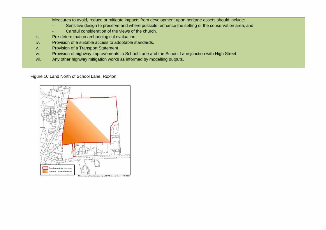
Measures to avoid, reduce or mitigate impacts from development upon heritage assets should include:
- Sensitive design to preserve and where possible, enhance the setting of the conservation area; and
- Careful consideration of the views of the church.
iii. Pre-determination archaeological evaluation.
iv. Provision of a suitable access to adoptable standards.
v. Provision of a Transport Statement.
vi. Provision of highway improvements to School Lane and the School Lane junction with High Street.
vii. Any other highway mitigation works as informed by modelling outputs.
Figure 10 Land North of School Lane, Roxton
Development site boundary
Potential Development Area

8. Place making
8.1 Our quality of living is affected to a great extent by our surroundings. This can also influence levels of crime, health, inclusion, community
cohesion and wellbeing. Development should add to what is locally distinctive or help to create a new sense of place where this is needed.
This local plan seeks to ensure that development creates attractive places, enhancing heritage assets, townscape characteristics and
local distinctiveness.
Policy 28S – Place making
Development will be expected to contribute to good place-making. This will be achieved by requiring development proposals:
i. To be of a high quality in terms of design and to promote local distinctiveness, and
ii. To have a positive relationship with the surrounding area, integrating well with and complementing the character of the area in
which the development is located, and
iii. To contribute to provision of green infrastructure, and
iv. To enhance the landscape, and
v. To take a proactive approach to sustaining and where appropriate enhancing the historic environment, and
vi. To avoid adverse impacts on biodiversity and geodiversity assets including, but not limited to, the Natura 2000 sites outside
Bedford borough listed in the Habitats Regulations Assessment (Appendix 1) and
vii. To respond to the unique character and importance of the River Great Ouse and its setting, and
viii. To include appropriate landscaping, and
ix. To contribute to the creation of the Forest of Marston Vale (when within or close to the Forest of Marston Vale area).
Design quality and principles
8.2 Government guidance in the National Planning Policy Framework identifies good design as a key aspect of sustainable development and
explains that it is indivisible from good planning. Good design helps to create distinctive places where people feel welcome and want to
live, work and relax. It includes both how a place looks and how it works, and supports the health and wellbeing of everyone affected by a
development. Successful place-making requires an understanding and respect for the area’s unique built, natural, cultural and socio-
economic context.

8.3 Good design ensures that buildings can be easily accessed by everybody and incorporates the specific needs of wheelchair users and
people with young children. Good design also has a role to play in planning out crime and enhancing community safety. Functional needs,
such as bin storage, car and cycle parking should be designed in from the start.
8.4 The Council produces a range of guidance documents that relate to and inform different aspects of design in the borough. These include:
Sustainable Drainage System SPD 2018
Parking Standards for Sustainable Communities SPD 2014
Open Space SPD 2013
A Strategy for Bedford High Street 2010
Climate Change and Pollution SPD 2008
Shopfronts and Advertisements in Conservation Areas SPD 2005
Mobility Housing SPD 2002
Achieving Quality in Residential Layouts SPG 1997
Residential Extensions, New Dwellings and Small Infill Developments SPG 2000
8.5 Further documents include Elstow Conservation Area Appraisal, Bedford Conservation Area Appraisal, Bedford Conservation Area
Maintenance and Repair Guide (see also paragraph 8.55) and various development briefs for specific sites.
8.6 Developers should have regard to these, and any future reviews or guidance documents when considering development in the borough.
8.7 The Council is committed to achieving high quality design in all new development and where appropriate, will work with developers to
prepare development briefs and design guidance for major development sites allocated in this local plan. These will set out the principles
of design with which new development will be expected to comply. Updated design guidance to guide the development of small
residential sites, infill development and extensions will also be produced, together with new guidance for the design of shopfronts.
Preparation of new and updated design guidance will appear in the Local Development Scheme.
8.8 Policy 29 is primarily concerned with development and its users but it should be read in conjunction with Policies 30-33 (Impact of
development – design impacts, access impacts, disturbance and pollution and infrastructure impacts).
Policy 29 – Design quality and principles
All new development should:
i. Be of the highest design quality and contribute positively to the area’s character and identity, and
ii. Respect the context within which it will sit and the opportunities to enhance the character and quality of the area and local
distinctiveness, and
iii. Protect and where appropriate, enhance heritage assets and their settings and successfully integrate with the historic environment
and character, and
iv. Have particular regard to the environment and biodiversity within it and ensure there are no significant effects on Natura 2000
sites (notably Portholme (SAC), The Ouse Washes (SAC/ SPA, Ramsar), Eversden and Wimpole Woods (SAC), Upper River
Nene Gravel Pits (SPA/Ramsar)) designated species or habitats, and
v. Promote accessibility and permeability for all by creating safe and welcoming places that connect with each other, and
vi. Promote a sense of place to include attractive streets squares and other public spaces with a defined sense of enclosure, with
multifunctional green spaces and corridors, and
vii. Incorporate measures to promote community safety ensuring that private and public amenity spaces are clearly defined and are
designed to be inclusive, useable safe and enjoyable, and
viii. Integrate functional needs such as refuse / recycling storage and collection points, car and cycle parking.
Proposals meeting the following criteria will be expected to be guided by a design code to be agreed with the local planning authority as
part of the application process:
i. Proposals for residential developments of 200 dwellings or more.
ii. Proposals for residential developments of 50 dwellings or more in areas with a historic urban form or where the landscape
interface with the built form is of importance.
iii. Other large scale developments.
The need for a design code should be discussed with the Council pre-application.
The impact of development
8.9 A key role of the planning system is to ensure that new development has a positive relationship with its surrounding area and that
adequate levels of amenity will be enjoyed by future occupiers or users of the proposed development. Careful design, layout, orientation
and landscaping are essential to ensure that proposals have a positive impact on others. Particular considerations include:
design and layout, including how the development relates to the surrounding area;
traffic generated by the development (including freight), access arrangements and parking;
noise, odour, obtrusive light and other emissions;

the impact on the existing tranquillity of the site and surrounding area;
overlooking, crime and community safety; waste storage and collection;
capacity of existing infrastructure, such as utilities, schools, health and community facilities.
8.10 Policies 30, 31, 32, and 33 set out the criteria that will be used to ensure that a proposal has a positive impact upon amenity.
Policy 30 – The impact of development - design impacts
Development proposals should take account of the principles of good design. Planning applications should give particular attention to all of
the following considerations:
i. The relationship of the development with the context in which it is placed, including overdevelopment; the contribution buildings
will make to the townscape and landscape qualities of the area; and where appropriate, the extent to which local distinctiveness is
reinforced or created.
ii. The quality of the development in terms of scale, density, massing, height, materials and layout, including the provision of private
space where appropriate.
iii. The quality of the public spaces created by new buildings in terms of public safety, hard and soft landscaping, and how buildings
interact with public space.
Developers will be required to implement or contribute towards measures to mitigate adverse impacts. Planning permission will not be
granted where proposals fail to improve the character and quality of an area.
Policy 31 – The impact of development - access impacts
Development proposals should not have any significant adverse impact on access to the public highway. Planning applications should
give particular attention to all of the following considerations:
i. Highway capacity, parking provision, safety or general disturbance to the area.
ii. The extent to which the development is served by, and makes provision for access by public transport, cyclists and pedestrians.
iii. The suitability of access arrangements to and within the development for all members of the community, including: pedestrians,
cyclists and people with disabilities.
iv. The suitability of access arrangements to and within the development for service and emergency vehicles.
Developers will be required to implement or contribute towards measures to mitigate adverse impacts.
Policy 32 – The impact of development - disturbance and pollution impacts
Development proposals should ensure that they minimise and take account of the effects of pollution and disturbance. Planning
applications should give particular attention to all of the following considerations:
i. Noise, vibration, smell, harmful emissions, impact on water quality, light glare or other disturbance or pollution which is likely to be
generated by the development.
ii. The existing tranquillity of the area.
iii. The suitability of the existing environment in relation to nuisance or pollution in the vicinity of the site.
iv. Factors which might give rise to disturbance to neighbours and the surrounding community, including overlooking, crime and
community safety concerns.
v. Arrangements for dealing with waste (including recyclable materials) storage and collection.
vi. The impact of development on locally, nationally and internationally important habitats (including Natura 2000 sites) as a result of
changes in ground water and surface water.
Developers will be required to implement or contribute towards measures to mitigate adverse impacts.
Policy 33 – The impact of development - infrastructure impacts
Development proposals should ensure that they do not have a harmful impact (including cumulative impact with other development) on the
adequacy of existing infrastructure, for example on utilities, schools, health and community facilities.
Developers will be required to implement or contribute towards measures to mitigate adverse impacts.
Advertisements
8.11 Government guidance in the National Planning Policy Framework recognises that poorly placed advertisements can have a negative
impact on the appearance of the built and natural environment. The Council will publish updated design guidance on advertisements.
Policy 34 is concerned with ensuring that advertisements do not have a harmful impact on amenity or public safety.

Policy 34 – Advertisements
Where planning permission or advertisement consent is required, or consideration is being given to a Discontinuance Notice,
advertisements should have a positive visual impact on a building or on its surroundings. Proposals will be considered against the
following factors:
i. Impact on the amenity of the surrounding area, particularly on heritage assets and their settings.
ii. Impact on public safety, particularly on the operation of highways.
The cumulative impact of advertisements on these factors will be a material consideration and conditions may be imposed where
necessary.
Green infrastructure
8.12 Green infrastructure refers to the network of natural and semi natural spaces and includes spaces such as parks, playing fields,
woodlands, allotments and street trees. These spaces can be in the urban and rural areas and also include water bodies. Green
infrastructure is important as it can not only deliver environmental benefits but also benefits for humans in the form of access to open
space. A wide range of research has been produced which shows the benefit of green infrastructure and its positive impact on the health
of the community and the natural environment. Green infrastructure can also enhance and conserve the historic environment by improving
the setting of heritage assets, improve access to it and help contribute to the sense of place and a tangible link with local history.
8.13 Within Bedfordshire, Green Infrastructure Plans have been produced in order to identify the opportunities for the protection and
enhancement of green infrastructure. The Bedford Borough Green Infrastructure Plan (2009) identifies the following 5 key themes of green
infrastructure:
Landscape
Historic environment
Biodiversity
Accessible green space
Access routes

8.14 The Plan identifies a strategic green infrastructure network which is divided into six separate Opportunity Zones. Policy AD24 ‘Green
Infrastructure Opportunity Zones’ in the Allocations and Designations Local Plan 2013 gives further detail about the zones and the
priorities for the protection and enhancement of green infrastructure within them. Policy AD24 will remain part of the development plan.
8.15 Strategic green infrastructure projects within the borough are the Forest of Marston Vale, Bedford River Valley Park and the Bedford to
Milton Keynes Waterway Park. Policies relating to the Bedford River Valley Park and the Bedford to Milton Keynes Waterway Park are
included in the Allocations and Designations Local Plan 2013 and are saved. A policy relating to the Forest of Marston Vale also appears
in the same plan but is replaced by Policy 36S below to update the wording on the implementation of the policy. This update is needed
because references to developer contributions are no longer relevant. Bedford Borough Council now has a Community Infrastructure
Levy and the Forest of Marston Vale is included in the list of projects that the Levy can be used for (the Regulation 123 list).
8.16 The requirement for new open spaces for sport and recreation alongside new development is included in the Allocations and Designations
Local Plan 2013 Policy AD28 and these standards will continue to apply.
8.17 A new policy regarding access to the countryside (public rights of way) is included in this plan Chapter 12 - Infrastructure.
8.18 Policies relating to the remaining three green infrastructure themes of landscape, the historic environment and biodiversity are below.
These replace policies in the 2002 local plan which pre-date the National Planning Policy Framework. The overarching Green
Infrastructure Policy replaces the 2008 Core Strategy and Rural Issues Plan policy which was adopted before much of the borough-wide
green infrastructure planning had been commissioned.
Policy 35S – Green Infrastructure
The existing green infrastructure in the borough shall be protected, enhanced and managed for the future benefit of the environment,
people and the economy.
Development shall provide a net gain in green infrastructure, while seeking to provide a high quality multi-functional green infrastructure
network in accordance with the Bedford Green Infrastructure Plan.
The Council will work with developers and other partners to deliver the three strategic green infrastructure projects: the Forest of Marston
Vale, the Bedford River Valley Park and the Bedford to Milton Keynes Waterway Park.

Forest of Marston Vale
8.19 The Council is a founding partner in the 40 year vision to create the Forest of Marston Vale across 61 square miles between Bedford and
Milton Keynes, as one of England’s Community Forests, which together form the country’s largest environmental regeneration initiative.
The National Planning Policy Framework provides specific support for community forests such as the Forest of Marston Vale, noting that
Forest Plans may be a material consideration in preparing development plans and in deciding planning applications.
8.20 The Forest of Marston Vale is one of the 12 Community Forests in England designated by Government as part of a national programme to
regenerate degraded landscapes near large urban populations through tree planting. It was established in 1991 to use trees and
woodlands to transform 61 square miles (approximately 16,000 hectares) between Bedford and Milton Keynes, repairing a landscape
scarred by decades of clay extraction, brickmaking and landfill. Working with local communities, government and businesses, the 40-year
vision is to deliver environmental regeneration that brings forward social and economic regeneration of the area, whilst providing major
landscape, recreation, biodiversity, and quality of life benefits.
8.21 The primary aim, set by government in 1991, is to increase tree cover from 3% to 30% by 2031, requiring the planting of around 4,000
hectares of new woodland. Approximately 50% of the Forest of Marston Vale area lies within Bedford borough, suggesting that 2,000
hectares of new woodland needs to be planted in the borough by 2031. In the last 21 years, there has been an increase of woodland
cover from 3.6% to 10.6% over the whole forest area, which equates to 1141 ha of new tree woodland. Overall tree cover within the
Forest has now increased to 15.4%.
8.22 Through delivering this major increase in woodland cover and landscape change, a wide range of associated benefits and objectives will
be delivered. The new well-wooded landscape will transform perceptions of the once-degraded area, encouraging inward investment and
economic prosperity, providing an attractive location in which to live and work and a revitalised area which local communities can be proud
of having helped to create through extensive community engagement. Recreation and leisure opportunities will be increased through the
creation of new accessible woodlands, other green infrastructure and access routes. Increased woodland cover will help mitigate the
impacts of climate change by providing a local, sustainable source of biomass for use as fuel, as well as through carbon sequestration by
the many millions of trees planted. With around 4,000 hectares of new woodland, plus other environmental improvements, the area will
deliver significant biodiversity benefits, creating a landscape richer in wildlife, as well as this new well-wooded landscape stimulating the
development of a woodland economy and associated job creation.
8.23 The creation of the Forest of Marston Vale is guided by the Forest Plan, a non-statutory plan produced through very extensive
consultation. The Forest Plan is the key reference for creating the Forest of Marston Vale, setting out the vision, objectives and broad
proposals for the 61 square mile area. The Forest of Marston Vale Trust is the independent registered charity dedicated to the
environmental regeneration and delivery of green infrastructure throughout the Marston Vale, in accordance with the Forest Plan.

8.24 In order to help the delivery of the 30% forest cover, developments within the Forest of Marston Vale will be expected to provide new tree
cover on the development site. This can be in the form of woodland in a major development site, through to individual trees and
hedgerows on smaller sites. A supplementary planning document will be produced in order to provide guidance on how to achieve the
policy requirements. New design guidance for development within the Forest of Marston Vale will be produced jointly with Central
Bedfordshire Council, forming a common Supplementary Planning Document, used by both Councils to inform development within the
Forest area.
Policy 36S – Forest of Marston Vale
Bedford Borough Council will continue to support the creation of the Forest of Marston Vale to deliver the environmentally led regeneration
of the area. Development proposals within the Forest of Marston Vale area will be required to:
i. Demonstrate how they will deliver 30% tree cover across their development site. This can be achieved through a combination of
new planting of trees, woodlands and hedgerows within development sites and
ii. Contribute to the environmentally led regeneration of the Forest of Marston Vale, in line with the aims of the Forest Plan and
iii. Demonstrate how their proposals reflect relevant design guidance (supplementary planning document) for development within the
Forest of Marston Vale.
Landscape
8.25 The landscape in Bedford borough has been influenced by a combination of human and physical influences. These landscapes, both
man-made and natural, are what make the area distinctive and there is a pressing need to conserve and enhance many of the features of
important landscape settings, as well as recognising the importance of views and vistas of these.
8.26 Some landscapes, particularly historic landscapes are more sensitive to change than others. Development can have an impact on the
landscape and can affect its character and quality. The degree to which development will become a significant or defining feature in the
landscape, including the skyline, and the likelihood of it becoming a feature in particular views is a key consideration in determining
planning applications.
8.27 A Landscape Character Assessment is a method of understanding what the landscape is like, how it came to be like that and how it may
change in the future. It also describes and classifies the recognisable and consistent pattern of elements that makes one landscape
different from another. Character is what makes each part of the landscape distinct and gives each area its particular sense of place. The
landscape character approach considers that all landscapes are valuable and seeks to protect their essential character. The purpose of a

Landscape Character Assessment is to help ensure that change does not undermine whatever is characteristic or valued about a
particular place, and ensure that ways of improving the character of a place can be considered.
8.28 A Landscape Character Assessment of Bedford borough was prepared in 2014. It identifies six landscape types within the borough:
Clay Farmland
Wooded Wolds
Limestone Valleys
Clay Valleys
Clay Vales
Wooded Greensand Ridge
8.29 The landscape types are further sub-divided into local landscape character areas, 13 in total. These are discrete geographic areas that
possess the common characteristics described for the landscape type and each character area has a distinct and recognisable local
identity. For each local landscape character area a detailed description of the landscape character is given that identifies the key
landscape features and visual sensitivities. In addition, guidelines for management and future development are produced as broad
principles to manage and direct landscape change, for example in order to protect the highest quality and most sensitive landscapes from
adverse change and to encourage positive change in weak or degraded landscapes.
8.30 In order to take account of local landscape considerations in the determination of development proposals, additional settlement specific
Landscape Sensitivity Studies were undertaken based on the 2014 Landscape Character Assessment. These Landscape Sensitivity
Studies draw on information in the Landscape Character Assessment and highlight the key landscape and visual sensitivities for the
settlement.
8.31 A Landscape Sensitivity Study has been produced for the Key Service Centres (Group 1) listed in paragraph 6.14, the Rural Service
centres (Group 2) listed in paragraph 6.15 and the edge of the urban area.
Policy 37 – Landscape character
Development proposals will protect and enhance the key landscape features and visual sensitivities of the landscape character areas
identified in the Bedford Borough Landscape Character Assessment May 2014 (or as subsequently amended).
Proposals will be required to:

i. Where appropriate incorporate and implement the landscape management guidelines and development guidelines laid out in the
BBLCA, and
ii. Protect and enhance the character and qualities of the local landscape through appropriate design and management, and
iii. Make provision for the retention and enhancement of features of landscape importance, and
iv. Safeguard and where possible, enhance key views and vistas, and
v. Protect the landscape setting and contribute to maintaining the individual and distinct character, and separate identities of
settlements by preventing coalescence, and
vi. Where appropriate, provide landscape mitigation.
Landscaping in new development
8.32 Landscaping is important not only for its visual qualities, but it can also help with climate regulation, biodiversity and the general mental
wellbeing associated with being outdoors in a green space. Published research identifies the benefits of green environments and
landscaping in the workplace, hospitals, the streetscape and residential areas. As part of the master planning of developments,
landscaping should be considered from the outset. The type and location of landscaping proposed is important to ensure the future
survival of the landscaping and to avoid future maintenance problems.
8.33 A supplementary planning document will be produced to provide guidance on the types of trees for inclusion as part of landscaping,
installation and future maintenance that is suitable for particular types of development.
Policy 38 – Landscaping in new development
Where appropriate, development shall provide landscaping on site or where more suitable, landscaping shall be provided off site and the
proposed scheme shall meet all of the following criteria:
i. Existing landscape features shall be recorded in a detailed site survey in accordance with the principles of the relevant industry
guidance and best practice.
ii. Existing features of landscape or nature conservation value should be incorporated into the landscaping scheme.
iii. The proposed landscaping scheme should consider the character of the site, site constraints, function, diversity of existing and
proposed landscaping, soil type, ecological value and resilience based on the location of the site.
iv. New tree planting as part of a proposed landscaping scheme will be selected, planted and established in accordance with current
best practice guidance within the relevant British Standard and shall have regard to guidance in the Council’s Trees and
Development SPD

v. Provision of the planting of hedgerows, shrub planting and other soft landscaping to include specimen trees with a mature height
of 15-20 metres within both hard and soft landscaped areas.
vi. The proposed landscaping shall make a positive contribution to the streetscape and integrate with the built development and
where applicable, adjoining developments.
vii. Trees within adoptable areas shall be incorporated as part of the infrastructure planning and design stage in accordance with
current best practice and shall have regard to the Council’s guidance in the Trees and Development SPD ensuring sustainability
and longevity.
viii. The proposed landscaping should not lead to significant effects on the Natura 2000 sites of Portholme (SAC) and the Ouse
Washes (SAC/SPA/Ramsar), as a result of surface run-off into the River Great Ouse.
Retention of trees
8.34 The aim is to retain and where possible increase overall tree canopy cover in the borough to meet a number of challenges we will face in
the future, namely the impact of climate change, ecological threats on the health of our existing native and non-native trees and increasing
pollution.
8.35 This means preserving and increasing our mature tree stock which plays the most important role in factors such as carbon storage,
particulate pollution absorption, storm water retention, neighbourhood improvement, ecological value, urban heat island effect, natural
health improvement zones, traffic calming and amenity. Many of these benefits can now be valued through natural capital accounting
which is the process of calculating the monetary value of natural capital such as trees, soils, minerals, water bodies and air.
8.36 The borough has a number of woodland sites, some of which are ancient woodland and contain historic hedgerows. Several of the sites
are recognised as being of national importance and are identified as Sites of Special Scientific Interest (SSSI), and sites of local
importance such as County Wildlife Sites (CWS). Individual trees and also small groups of trees can also have a positive impact on the
environment for both the natural environment and for human health related benefits of being near and being able to see trees.
8.37 Ancient trees have been mapped by the Woodland Trust, however their records do not provide an exhaustive list. Veteran trees also have
an important purpose providing habitat for a range of wildlife especially fungi and invertebrates.
8.38 Under the Town and Country Planning Act 1990, the Council has the power to serve Tree Preservation Orders where appropriate to
ensure the treed landscape is protected.

8.39 Developers should provide a detailed tree survey as part of a planning application. This should be carried out in accordance with the
relevant British Standard and the Council’s Tree Supplementary Planning Document (SPD), including an assessment of ancient and
veteran trees. Where trees are proposed to be removed, it should be demonstrated in the planning application the reasons for the removal
and any proposals for replacement trees. Where appropriate, replacement trees or mitigation measures will be sought through the
imposition of planning conditions.
8.40 Development proposals should ensure that proposed building works will not encroach into tree exclusion zones and that retained trees are
protected during construction in accordance with the relevant British Standard. These measures should be outlined in the planning
application.
Policy 39 – Retention of trees
In considering proposals for development all of the following criteria will apply:
i. Applicants shall consider opportunities to retain trees of high amenity and environmental value taking into consideration both their
individual merit and their contribution as part of a group or broader landscape feature. Existing trees on and immediately adjacent
the development site shall be recorded following guidance in the relevant British Standard.
ii. Development applications shall provide details as to how the retained trees, hedges and hedge banks will be protected prior to,
during and after construction.
iii. No building, hard surfacing drainage or underground works will be permitted that does not accord with the principles of the
relevant British Standard unless, exceptionally, the Council is satisfied that such works can be accommodated without harm to the
trees concerned or there are overriding reasons for development to proceed.
iv. Planning permission will be refused for development resulting in the loss or deterioration of ancient woodland and the loss of aged
or veteran trees found outside ancient woodland (including from indirect impacts such as increased visitor pressure), unless the
need for, and benefits of, the development in that location clearly outweigh the loss.
v. The Council will protect existing trees through the making of Tree Preservation Orders where appropriate.
Hedgerows
8.41 Hedgerows are a familiar feature in the countryside and are also used extensively in the urban area along property boundaries. They are
useful in providing windbreaks, privacy between dwellings and for providing habitats for many different species, particularly for bird nesting
and butterflies. Hedgerows can also prevent soil loss, regulate water supply, reduce flooding and act as carbon storage.
8.42 The Hedgerows Regulations 1997 are applicable to particular types of hedges and there are set procedures outlined in the regulations to
follow to ensure their protection. While there are separate regulations, hedgerows still provide a valuable resource in the countryside as
well as providing a feature in the landscape and should be considered as part of the development of a site. This is recognised in their
inclusion as a habitat of ‘principal importance’ to biodiversity under Section 41 of the Natural Environment and Rural Communities Act
2006.
8.43 As part of a planning application, the landscaping scheme shall provide details of the existing hedgerows on the site, including an
assessment of their health.
Policy 40 - Hedgerows
Any hedgerows should be retained on development sites, unless there are overriding benefits that justify their removal. Where removal is
deemed necessary, details addressing the criteria under the Hedgerow Regulations 1997 (as amended) shall be submitted to demonstrate
the validity for removal and details of the replacement hedgerows. Replacement hedgerows shall be of an equal scale, native and species-
rich and should be provided where possible, elsewhere on the development site.
Where there are gaps in the existing hedgerows on the site, the development should provide for additional hedgerow planting.
Historic environment
8.44 Bedford borough’s historic environment makes a large contribution to the local character and distinctiveness of the borough through its
archaeology, historic landscapes, townscapes, rural settlements, and vernacular building styles and materials.
8.45 The archaeological, architectural, artistic and/or historic interest of individual and groups of heritage assets, the story they tell about past
human activity and their positive contribution to the character of the area is valuable. Policies in the Local Plan provide a framework for
managing change to the historic environment, which sustains and enhances Bedford borough’s unique qualities, sense of place, local
distinctiveness, economic vibrancy, and residents’ well-being.
8.46 The historic environment and its individual heritage assets are a finite resource, in need of protection and sensitive management.
Heritage assets suffering from a lack of maintenance, neglect, vacancy and/or are no longer fit for purpose may be considered ‘at risk’ and
identified on either the local or national register. Where this is the case the Council will work with owners and stakeholders to ensure the
long-term conservation of the asset.

8.47 Informing and managing change to Bedford borough’s historic environment is underpinned by the Historic Environment Record, an
archive, database and mapping resource kept by the Council of all known heritage assets in the borough. It contains both ‘designated’
and ‘non-designated’ heritage assets, and is the main historic environment evidence base. It has over 11,000 entries that include the
following designated heritage assets:
28 conservation areas
Over 1,300 listed buildings
8 registered parks and gardens
69 scheduled monuments
8.48 The borough’s wealth of non-designated heritage assets originates from all periods of the borough’s history. The significance of these
assets can be seen in both a local and regional context. They can be or comprise part of:
The historic landscape, including distinctive settlement patterns such as village ends or smallholdings, earthworks, field systems and
boundaries, trees, woodlands and commons and historic farmsteads such as the model farmstead at Chawston Manor.
Designed landscapes including parkland such as that surrounding Turvey Hall, estates, gardens, public parks like Russell Park,
urban open spaces, churchyards, cemeteries, waterbodies and wetland, and industrial, military, institutional or aviation landscapes
including former Thurleigh Airfield, and their associated buildings and structures.
Historic transportation networks such as the River Ouse Navigation and infrastructure, including prehistoric route ways, medieval
and post-enclosure roads, trackways and green lanes, canals and locks, river bridges and fords, railways and their associated
industries.
The historic county town of Bedford set on the River Ouse, with its complex heritage of street and plot patterns, civic, religious and
town buildings, market places, medieval places and open spaces.
The historic cores of Bedford borough’s urban area settlements and rural villages, with their religious, manorial and market
components and wide variety of vernacular building styles and materials, street and plot patterns.
A site or monument of archaeological interest which has not yet been scheduled or is unsuitable for scheduling but nonetheless is
demonstrably of equivalent significance to a scheduled monument.
Buried or submerged archaeological remains.
Management of Heritage Assets
8.49 As well as helping to make the borough a desirable place to live, visit and work, the historic environment can also play a significant role in
attracting investment into the area.

8.50 Conservation and, where possible, enhancement of heritage assets, must be based on an informed understanding of their significance,
including contributions from setting and to the wider area, and assessment of their potential for increasing understanding of past human
activity for the benefit of present and future generations.
8.51 This understanding is normally the product of a desk-based assessment or heritage statement, and where involving a historic building or
structure, a heritage impact assessment. Where there is the potential for heritage assets of archaeological interest (typically ‘below-
ground archaeological remains’) an archaeological field evaluation can confirm their presence or absence, date and significance.
8.52 Pre-application discussions are strongly encouraged, as this will allow for early identification of historic environment issues, helping
provide guidance on appropriate assessment methods to inform proposals, and towards improving the quality of applications. Alongside
relevant policies and guidance, regard will need to be had to the provisions of legislation relating to designated heritage assets including
the Ancient Monuments and Archaeological Areas Act 1979 and the Planning (Listed Building and Conservation Areas) Act 1990 (or their
successors).
8.53 Applications will be supported where they preserve, and where possible, enhance the significance of heritage assets including through
development/alterations within their setting
Conservation areas
8.54 Bedford borough has 28 conservation areas in 2018 ranging from the urban town centre to rural village settlements.
8.55 A number of the borough’s conservation areas have adopted conservation area appraisals and management plans. These documents
identify the special interest and significance of a conservation area setting-out a management strategy to ensure this interest/significance
is retained and where possible enhanced, and will be used by the Council to guide the development management process. For instance,
spaces between buildings such as village greens or the remnants of historic street patterns, can contribute positively to the character of a
conservation area.
8.56 Planning permission may be required to demolish a building or structure within a conservation area. There is a general presumption in
favour of retaining buildings and structures that make a positive contribution to a conservation area’s character.
Listed buildings
8.57 There are over 1300 listed buildings in Bedford borough.

8.58 Listed building consent is required for any demolition, alterations (interior and/or exterior) or extensions to a listed structure, considered to
affect its special interest or significance. This also extends to any curtilage listed structure such as agricultural barns and stables, or
boundary walls. A listed building’s setting may also contribute to its significance, is not fixed and can change over time as surroundings
evolve. Elements of setting can make a positive or negative contribution to significance.
8.59 In many cases the original use will be the most sympathetic and the potential to restore or continue that use should be fully assessed
before alternatives are considered. Where any change of use, conversion, adaptation or demolition is proposed, their impact on the
significance of the building or structure and its setting will need to be fully assessed.
8.60 Enabling development is development contrary to planning policy but which may be supported due to associated public benefits which
otherwise could not be achieved. The Council may consider a degree of enabling development that will achieve the conservation of a
listed building (or other designated heritage asset) and secure it a viable and sustainable future. This is a rigorous test with extensive
requirements clearly set out in existing national guidance. In such circumstances applicants will normally be required to contribute to the
Council’s costs in assessing such applications.
Registered Parks and Gardens
8.61 Within the borough, there are 8 Registered Parks and Gardens of Special Historic Interest including Bedford Park, Hinwick Hall and the
Arts and Crafts garden at the Three Gables, Biddenham.
8.62 The effect of proposed development/works on a Registered Park or Garden is a material consideration in the planning process.
Scheduled monuments
8.63 Under the Ancient Monuments and Archaeological Areas Act 1979 (as amended), scheduled monuments are nationally important
archaeological sites and monuments afforded legal protection. The Secretary of State has a duty to compile a list or ‘schedule’ of these,
the purpose being to help preserve them so far as possible in the state in which they have come down to us today. Qualifying
monuments have been carefully selected against formal selection criteria and placed on the Schedule. As of 2018, there are fewer than
20,000 scheduled monuments in England, representing a tiny fraction of the nation’s archaeological resource as a whole, with only 69 of
these found in Bedford borough. Where planning permission is granted for works that directly affect a scheduled monument, this does not
remove the need for Scheduled Monument Consent.

Non-designated heritage assets
8.64 These may be buildings, monuments, archaeological sites, places, areas or landscapes which have demonstrable heritage significance.
Those having such significance will be treated as a material consideration in the planning process.
Local list
8.65 The Council will produce a local list. Inclusion of assets will be determined against specific heritage criteria.
Policy 41S - Historic environment and heritage assets
i. Where a proposal would affect a heritage asset the applicant will be required to describe :
a. The significance of the asset including any contribution made by its setting and impacts of the proposal on this significance,
and
b. The justification for the proposal, how it seeks to preserve or enhance the asset/setting or where this is not possible, how it
seeks to minimise the harm.
ii. This description must be in the form of one or a combination of: a desk based assessment; heritage statement; heritage impact
assessment; and/or archaeological field evaluation. Further information will be requested where applicants have failed to provide
assessment proportionate to the significance of the assets affected and sufficient to inform the decision-making process.
iii. Where a proposed development will lead to substantial harm to (or total loss of significance of) a designated heritage asset or non-
designated heritage asset of archaeological interest of demonstrably equivalent significance to a scheduled monument, consent will
be refused unless it can be demonstrated that the substantial harm or total loss is necessary to achieve substantial public benefits
that outweigh that harm or loss, or all of the following apply: a) the nature of the heritage asset prevents all reasonable uses of the
site; and b) no viable use of the heritage asset itself can be found in the medium term through appropriate marketing that will
enable its conservation; and c) conservation by grant-funding or some form of not for profit, charitable or public ownership is
demonstrably not possible; and d) the harm or loss is outweighed by the benefit of bringing the site back into use.
iv. Where a development proposal will lead to less than substantial harm to the significance of a designated heritage asset, this harm
will be weighed against the public benefits of the proposal including, where appropriate, securing its optimum viable use.
v. In considering proposals affecting designated heritage assets or a non-designated heritage asset of archaeological interest of
demonstrably equivalent significance to a scheduled monument, involving their alteration, extension, demolition, change of use
and/or development in their setting, the Council will include in their consideration as appropriate:
a. The asset’s archaeological, architectural, artistic and historic interest and any contribution to its significance from setting
(including the wider historic landscape)
b. scale, form, layout, density, design, quality and type of materials, and architectural detailing

c. boundary treatments and means of enclosure
d. implications of associated car parking, services and other environmental factors
e. effect on streetscape, roofscape and skyline including important views within, into or out of heritage assets
f. impact on open space which contributes positively to the character and/or appearance of heritage assets
g. the positive benefits of the proposal in addressing heritage at risk.
vi. Where heritage assets are included on a Local List and are affected by development proposals the Council will afford weight
proportionate to their heritage significance in the decision-making process to protect and conserve the significance which underpins
their inclusion. Partial or total loss adversely impacting this significance will require clear and convincing justification.
vii. The effect of proposals on the significance of non-designated heritage assets will be taken into account in determining applications
for development. Applications which result in harm or loss of significance to non-designated heritage assets will only be supported if
clear and convincing justification has been demonstrated. In making a decision, the Council will weigh the significance of the
heritage asset affected against the scale of any harm or loss to it.
viii. Where applications are permitted which will result in (total or partial) loss to a heritage asset’s significance (including where
preservation in situ of buried archaeological remains is not necessary or feasible), applicants will be required to arrange for further
assessment of and recording of this significance in advance of, and where required, during development/works. This assessment
and recording must be undertaken by a suitably qualified specialist in accordance with a design brief set by the Council’s Historic
Environment Team. The work might include:
archaeological and/or historic building fieldwork,
post-excavation/recording assessment, analysis, interpretation,
archiving with the local depository, and
presentation to the public of the results and finds in a form to be agreed with the Council.
As a minimum, presentation of the results should be submitted to the Bedford Borough Historic Environment Record and where
appropriate, will be required at the asset itself through on-site interpretation.
Protecting biodiversity and geodiversity
8.66 Biodiversity is the variety of all life living on Earth. It forms the building blocks for the natural environment, underpinning many natural
processes which support our economic and social wellbeing. The decline in biodiversity has been well documented. When the Natural
Environment White Paper (The Natural Choice: securing the value of nature) was published in 2011 it based what was required to halt the
decline on the findings of the report ‘Making Space for Nature’ also known as the Lawton Report. This found that England’s wildlife sites
were fragmented and stated that resilient ecological networks are needed to provide a step change in nature conservation. It summarised
how these networks should be created in four words; more, bigger, better and joined. In recognition of this, national planning policy has

incorporated the importance of protecting and enhancing ecological networks and producing a net gain in biodiversity. This includes
protecting existing sites, alongside taking opportunities to create new sites, linkages and stepping stones for wildlife as part of
developments.
8.67 Alongside biodiversity, geodiversity relates to the variety of physical processes on the earth and the resulting rocks, fossils, minerals,
natural processes, landforms and soils that determine the character of our landscape and environment. There are a variety of geodiversity
sites across the borough from rock exposures to historic bridges which display the region’s geological heritage.
8.68 A biodiversity characterisation study was published for Bedford borough in 2009 as part of the ‘Rebuilding Biodiversity’ opportunity
mapping by the Bedfordshire and Luton Biodiversity Partnership (now the Wildlife Working Group). This report followed on from the
Bedfordshire study published in 2006. The studies identified existing biodiversity assets and used them to map ecological networks at
both the borough and county levels. The studies also summarised the characteristics of each network, including the species and habitats
found there and then looked for opportunities to enhance the network across the landscape. The studies can be found on the
Bedfordshire and Luton Biodiversity Recording and Monitoring Centre’s (BRMC) website.
8.69 There are many features which contribute towards ecological networks. Recognised wildlife sites are a key one as they are hotspots for
biodiversity. Depending on their location within the landscape, they can also provide corridors or stepping stones for wildlife moving
across the wider landscape. Recognised wildlife sites can be divided into statutory sites and non-statutory sites. Statutory sites within
Bedford borough include Sites of Special Scientific Interest (SSSI) and Local Nature Reserves (LNR). There are no National Nature
Reserves, European or internationally designated sites within the borough, although the Upper Nene Valley Gravel Pits Special Protection
Area (SPA) is located to the north within Northamptonshire.
8.70 Natura 2000 sites (or European sites) are a network of sites established under the Birds Directive and the Habitats Directive. The UK is
bound by the terms of these directives and development is to ensure that adverse effects on a European site would be avoided and that
no development would adversely affect the integrity of a European site. Under The Conservation of Habitats and Species Regulations
2017, a Habitats Regulations Assessment is to be carried out by the developer to assess the potential impacts of development on a
European site.
8.71 Sites of Special Scientific Interest (SSSI) are nationally important sites that contain the best examples of the UK’s flora, fauna, geological or
geophysical features. They are designated by Natural England and protected by The Wildlife and Countryside Act 1981 (as amended).
SSSIs can be in public or private ownership, or be owned by non-profit organisations such as wildlife trusts. There are eight SSSI in
Bedford borough covering examples of wetlands, grasslands, woodlands and a geological site. They are:
Yelden Meadows

Felmersham Gravel Pits
Tilwick Meadow
Odell Great Wood
Hanger Wood
Swineshead Wood
Stevington Marsh
Biddenham Pit
8.72 Local Nature Reserves are sites in the control of and are suggested by a local authority, but designated by Natural England. They are of
local importance and have wildlife or geological interest. The sites are publicly accessible and have a management plan in place to
ensure their biodiversity or geodiversity is maintained and the wildlife is not damaged as a result of public access. The Local Nature
Reserves in Bedford borough are:
Fenlake Meadows
Park Wood
Bromham Lake
Hill Rise
Putnoe Wood
Mowsbury Hill
Browns Wood
Harrold Odell Country Park
8.73 Locally important sites are non-statutory and are known in Bedford borough as County Wildlife Sites (CWS), Roadside Nature Reserves
(RNR) and Local Geological Sites (LGS). CWS and LGS are identified by the County Wildlife Site Panel and the Local Geological Site
Panel respectively. For a site to be identified, it must meet set criteria and be agreed by a panel of experts. The assessment of the non-
statutory sites is overseen by the Local Sites Partnership of which Bedford Borough Council is a member. Further details and criteria for
Local Sites can be found on the Bedfordshire and Luton Recording and Monitoring Centre webpage. The Greensand Ridge Nature
Improvement Area stretches over 45 km and has an area of 273 km2 and includes a small area to the south of Wilstead within Bedford
borough. The unique landscape along the ridge is home to a wide range of species and habitats, and is one of the few places in Central
England which supports lowland heathland and acid grassland. Green Infrastructure Zone 5; The Greensand Ridge Fringes covers this
area. Policy AD24 (Allocations and Designations Local Plan Chapter 7) requires the protection, enhancement and creation of green
infrastructure (including biodiversity).

8.74 Not all wildlife habitats and species are found within recognised wildlife sites and many including protected species, are found across the
wider landscape. It is a requirement under Section 41 of the Natural Environment and Rural Communities (NERC) Act, 2006 that local
authorities have regard to the conservation of biodiversity. To assist with this, Section 40 of the same Act contains a list of species and
habitats of ‘principal importance’ for the conservation of biodiversity. This goes beyond the list of species which have European protection
or are protected under the Wildlife and Countryside Act, 1981 (as amended). Within Bedford, there are over 140 species of ‘principal
importance’. The habitats of ‘principal importance’ have been mapped for Bedford borough. While this mapping is not comprehensive, it
provides a useful tool for identifying areas which are important for biodiversity and to help identify gaps and form linkages to enhance
ecological networks. The list of habitats and species of ‘principal importance’ used with the NERC Act was based on the national
Biodiversity Action Plan list. Locally the original Bedfordshire Biodiversity Action Plan was published in 2001 and the targets were updated
in 2007. These have been refreshed by the Wildlife Working Group in 2015 and have been endorsed by the Bedfordshire Local Nature
Partnership. The BRMC collate individual species records and these are available, along with habitats and identified wildlife sites, as part
of the evidence base for planning applications and site management plans.
8.75 National planning policy states that development should deliver a net gain in biodiversity. Bedford Borough Council has been granted a
District Licence as part of the Bedfordshire District Licence Scheme for Great Crested Newts. This enables the Council through its
planning function to authorise activities affecting Great Crested Newts. Developers will be required to pay compensation for their impacts
of the proposed development which will enable management agreements to be put in place with land owners and managers to fund and
maintain newt habitats for the next 25 years which is more effective for newts on sites and on a landscape scale. To achieve this,
biodiversity and geodiversity need to be considered at the earliest stage within a planning proposal. Each proposal should consider what
existing biodiversity or geodiversity assets already exist on or around the site. These assets could include identified wildlife sites,
hedgerows, orchards, watercourses or individual trees. Development proposals should then be designed around these assets and how
they link to wider ecological networks. Where there is a reasonable likelihood that protected species may be affected by a planning
proposal, professional advice must be sought to ensure that protected species are safeguarded through the development process. The
assessment should be carried out be a suitably qualified professional in accordance with industry standards and submitted as part of the
planning application. Other rare and endangered species and habitats should also be considered, including those of ‘principal importance’
or with local Biodiversity Action Plans. Where there are particular species or habitat identified which may be adversely affected by the
proposed development, proposals will be expected to follow the mitigation hierarchy provided by national planning policy. In the mitigation
hierarchy there is a preference for negative impacts to be avoided, however, where this is not possible, mitigation should be used and
then, as a last resort, compensation. Planning applications shall clearly demonstrate how the net increase in biodiversity will be achieved
through the development. Site and species specific surveys are an important part of assessing applications and so must be provided with
a planning proposal.
8.76 The proposals for enhancement of biodiversity will depend on the nature and scale of the development. There are many innovative
systems that can be incorporated into small spaces to increase biodiversity such as green roofs, green walls and sustainable urban

drainage systems. The choice of species included in landscaping schemes can be used to enhance ecological networks, as can the
inclusion of bat and bird boxes as well as hedgehog holes under fences within developments.
Policy 42S – Protecting biodiversity and geodiversity
Planning applications for development are required to assess the impact of the proposal on the biodiversity and geodiversity value of the
site and its surroundings. This should be carried out by a suitably qualified professional in accordance with industry standards.
A proposal which is likely to have an adverse effect on a Site of Special Scientific Interest (SSSI) or Natura 2000 site will not be permitted
unless there are exceptional reasons that outweigh the harm to the site.
Development should be designed to prevent any adverse impact on locally important sites, species and habitats of principal importance
contained within the Natural Environment and Rural Communities (NERC) Act 2006. However in these circumstances where an adverse
impact is unavoidable, the application shall demonstrate how the harm will be reduced through appropriate mitigation.
Where protected species or priority habitats of principal importance are adversely affected, the application will need to demonstrate how
the proposed mitigation will reduce the adverse effects. If adequate mitigation is not possible, the application will need to demonstrate that
the overriding reasons outweigh the impacts on the biodiversity and geodiversity of the borough otherwise the development will be refused.
Developments with potential to have an adverse impact, either alone or in-combination, on the integrity of a European Designated Site will
be assessed in accordance with the requirements of the Habitats Regulations.
Policy 43 – Enhancing biodiversity
Development proposals should provide a net increase in biodiversity through the following:
i. Enhancement of the existing features on the site; or
ii. The creation of additional habitats on the site; or
iii. The linking of existing habitats to create links between ecological networks and where possible, with adjoining features.

River Great Ouse
8.77 The River Great Ouse is an integral feature through Bedford borough. It is a focal point for formal and informal recreation and sport, and
supports a range of biodiversity.
8.78 The Bedford Waterspace Study was commissioned by the Environment Agency and Bedford Borough Council and was published in 2011.
The scope of the study was the river corridor from the limestone Bromham Bridge to Willington Lock. The study was produced to help
inform the future development along the River Great Ouse and highlight Bedford’s potential as a waterway destination.
8.79 Potential improvements to facilities along the river were identified in the Waterspace Study, along with access opportunities to the river
corridor in the form of footpaths and cycle paths. In addition, improvements for river users in and adjoining the river were identified such
as canoe portages and navigational improvements for boats.
8.80 The Environment Agency in conjunction with the Bedford and Milton Keynes Waterway Trust are currently investigating extending the
head of navigation of the river along the western section of the river. This will enable boats and canoes to safely navigate from the town
centre to Kempston Weir.
8.81 The following policy applies to development proposals on or connected to the river, for example moorings or marinas.
Policy 44 – River Great Ouse
Development proposals along and adjoining the River Great Ouse will be required to:
i. Improve access to the River Great Ouse including canoe portage areas and related facilities will be supported as outlined in the
2011 Bedford Waterspace Study (or as amended) where it can be demonstrated that there will be no harmful impact on the
character or environment and
ii. Deliver improvements as relevant to the site and area of the river which have regard to the 2011 Bedford Waterspace Study and
iii. Ensure that new river moorings have pedestrian access and vehicle access to an adopted road, unless it can be demonstrated that
there is an alternative means of access and
iv. Ensure that new marinas have access to an adopted road and car parking is provided in accordance with the Parking Standards for
Sustainable Communities: Design and Good Practice supplementary planning document to accommodate visitors’ and residents’
vehicles and
v. Ensure that any new development or activities do not lead to adverse impacts on Natura 2000 sites downstream of Bedford i.e.
Portholme (SAC) and The Ouse Washes (SAC/SPA/Ramsar) including as a result of increased flooding or because of pollution.

Local Green Space
8.82 The Allocations and Designations Local Plan 2013 affords protection to Village Open Spaces and Urban Open Spaces through policies
AD40 and AD43 respectively. Since these policies were adopted and open space sites identified on the Policies Map, the National
Planning Policy Framework has introduced a new higher tier of protection for open spaces called Local Green Space.
8.83 Local Green Spaces can only be designated in Local Plans or Neighbourhood Plans. In accordance with national policy this designation is
not appropriate for most areas of open space or green areas within the borough. In order to be designated, an open space must meet a
strict set of criteria. The NPPF 2012 explained that the Local Green Space designation will not be appropriate for most green areas or
open space and should be capable of enduring beyond the end of the plan period.
8.84 As part of the preparation of the Local Plan 2030, parish councils and the general public were invited to submit sites for consideration as
Local Green Spaces. The sites were assessed in accordance with the Council’s interpretation of the criteria in the NPPF. Those sites that
are considered to meet the criteria are designated as Local Green Spaces and are shown on the Policies Map.
8.85 Where open spaces that were designated as Village or Urban Open Spaces in the Allocations and Designations Local Plan 2013 were put
forward and met the strict tests associated with the national Local Green Space designation, they are now identified on the Policies Map
as Local Green Spaces and Policy 45 of this plan will apply. Remaining Village and Urban Open Spaces continue to be shown on the
Policies Map and proposals on them will continue to be considered in accordance with local policies AD40 and AD43.
Policy 45 – Local Green Space
Local Green Spaces are designated on the Policies Map and have been determined as demonstrably special to the local communities they
serve. Development proposals which result in the loss of part or all of a Local Green Space or would have a negative impact on the
features that make it locally significant will not be permitted unless very special circumstances can be demonstrated.

9. Resources and climate change
Introduction
9.1 Soil, air and water resources are non-renewable resources and their use needs to be managed carefully to ensure that development is
sustainable. Development is needed to support social and economic growth however it is important to minimise any harmful impacts that
it might cause. This chapter also looks at the challenge of climate change and how we should respond to it.
Use of previously developed land and use of undeveloped land
9.2 The Government’s National Planning Policy Framework encourages the effective use of land by reusing land that has been previously
developed. Not all previously developed land is suitable for building however, for example it may be of high environmental value or be
found in an isolated location. This local plan sets out the strategy for where development should occur. Furthermore, the Council has
published a brownfield land register which lists previously developed land that is considered to be appropriate for residential development.
9.3 The Government’s National Planning Policy Framework states that, where significant development of agricultural land is necessary, local
planning authorities should seek to use poorer quality land in preference to that of higher quality. Agriculture is a major use of land in the
borough and a significant proportion of farmland and other undeveloped land is classified as the ‘best and most versatile’ (i.e. grades 1, 2
and 3a). The Government’s available survey information is not accurate at the level of individual sites and does not always distinguish
between grades 3a and 3b. Therefore the quality of undeveloped sites generally needs to be determined by specific analysis.
Policy 46S – Use of previously developed land and use of undeveloped land
The Council will seek to maximise the delivery of development through the reuse of suitably located previously developed land provided
that it is not of high environmental or biodiversity value.
Where significant development is demonstrated to be necessary on agricultural land, poorer quality land should be used in preference to
the best and most versatile agricultural land (grades 1-3a). Where the site is located on agricultural land outside of existing settlements,
applicants will be required to provide evidence of the grade of agricultural land and, where that land is likely to be grade 3 or higher,
undertake a detailed survey of land quality.
Pollution, disturbance and contaminated land
9.4 The Government’s National Planning Policy Framework expects the planning system to minimise the effect of soil, air, water and noise
pollution on both the natural environment and on existing and proposed development. The control of pollution is a complex process
involving both the Council and other statutory bodies.
9.5 Where development is proposed on or adjoining land which is known, or suspected to contain or cause pollution the Council will require
that all practicable and effective measures to investigate and remediate the site have been undertaken. It is the developer’s responsibility
to ensure that the site is safe for development.
9.6 The amount of artificial lighting clearly distinguishes built-up areas from the countryside. When well-designed, artificial lighting can
improve public safety. However, if the light direction and intensity is poorly designed it can cause light pollution from glare, scatter or
spillage. The Council will consider the impact of any lighting scheme on the character of the area as well as on local residents and
highway users.
9.7 There is one Air Quality Management Area in Bedford, which has been designated where the annual mean level of nitrogen dioxide
exceeds national air quality standards. The main source of nitrogen dioxide is vehicle emissions. Regular monitoring of the nitrogen
dioxide levels occurs and the Council has developed an Air Quality Action Plan.
9.8 Land stability can also be an issue, particularly in relation to minerals and waste proposals. All development should take account of
ground conditions and land instability to ensure that the site is suitable for its new use and will not have any unacceptable adverse
impacts.
9.9 Development proposals which are located close to permitted or allocated mineral and waste sites may require a tract of land within which
no development should take place to ensure that no new incompatible development encroaches upon existing permitted and allocated
mineral and waste management sites. Buffer zones may be landscaped to alleviate noise and improve visual appearance. The size of
the buffer zone required will be determined by the type of operation and particular site circumstances. However, buffer zones would
normally be expected to be set at around 200 metres for mineral working and inert waste disposal, and around 250 metres for waste
management facilities unless appropriate mitigation can be agreed. Where the proposal generates legitimate health concerns the Council
may require a risk assessment to be undertaken as part of the planning process.
9.10 Where new non-waste development involving buildings which would normally be occupied is proposed within close proximity of a water
recycling centre, the application should be accompanied by an odour assessment report, which considers existing odour emissions of the
site at different times of the year and in a range of different weather conditions.

Development proposals which are located in an area where existing uses may generate significant noise or be otherwise disruptive (“bad
neighbour” uses) must demonstrate that the proposed use would be suitable in that location.
Policy 47S – Pollution, disturbance and contaminated land
All development proposals will be required to:
i. Prevent the emission of significant levels of pollutants into the soil, air or water and
ii. Avoid noise giving rise to significant adverse impacts on health and quality of life or, where appropriate, mitigate and reduce its
impact and
iii. Avoid any significant impact of artificial light on local amenity. Details of any external lighting scheme required as part of a new
development should be submitted with the application and
iv. Reduce as far as practicable other potential impacts including from: vibration, dust, mud on the highway, smoke, fumes, gases,
odours, litter, birds or pests and
v. Be appropriate for their location, having regard to the existing noise, air quality, ground stability or pollution environment, including
the proximity of pollutants, hazardous substances and noise generating or disruptive uses and
vi. Remediate and mitigate despoiled, degraded, derelict, contaminated and unstable land so that it is suitable for its proposed use.
All minerals and waste development proposals will be expected to demonstrate that an adequate buffer zone exists between the proposed
development and neighbouring existing or proposed sensitive land uses. The Council will resist development proposals within the buffer
zone that could be adversely affected by the mineral or waste operation or could prejudice the ability of the operator to work the
permission.
Developers are required to submit sufficient information to enable development proposals to be properly assessed.
Minerals and waste restoration policy
9.11 The Minerals and Waste Local Plan: Strategic Sites and Policies, 2014 explains the vision, objectives and strategy for minerals and waste.
It also identifies strategic sites for minerals and waste development.
9.12 The Council is committed to achieving higher standards of restoration of mineral extraction and landfill sites. One way of minimising the
impact of mineral and waste uses is to ensure that they are restored at the earliest opportunity and left in a safe state capable of
sustaining an acceptable after use. On larger sites restoration will be required to be progressive in nature and to take place within a
reasonable timescale so that only a portion of the whole site is disturbed by mineral extraction or waste disposal operations at any one
time. Applicants will normally be required to submit an aftercare scheme for a period of five years following restoration to ensure that the

restoration scheme is maintained until it becomes naturally self-sustaining. In certain cases it may be appropriate to agree a shorter or
longer period, depending on the nature of the restoration scheme.
9.13 Certain forms of mineral and waste developments may attract large number of birds, for example landfill sites or former sites restored to
nature conservation. Proposals for sites which might have an impact on aviation safety will need to be rigorously assessed.
Policy 48 – Minerals and waste restoration policy
All proposals for minerals and waste development (including ancillary development) will, where relevant, be expected to:
i. Include the high quality progressive restoration and aftercare of the site and
ii. Be limited to the duration of the main operation and
iii. Be carried out in a manner which will preserve or improve the long-term quality of soils and land and
iv. Include an assessment of ground stability conditions before and after the completion of all site activities and demonstrate that
there will not be any unacceptable adverse impacts and
v. Include an assessment of the impact on aviation safety and demonstrate that there will not be an unacceptable adverse impact.
Waste
9.14 Government guidance expects local planning authorities when considering planning applications to ensure that sufficient provision is made
for waste management, including adequate storage facilities at residential premises. The handling of waste arising from the construction
and operation of development should maximise reuse/recovery opportunities and minimise off-site disposal. Policy 49 applies to all forms
of development. The policy is intended to ensure that waste management issues are considered at the design stage, and that suitable
measures are incorporated to minimise generation of waste and facilitate recovery of resources from waste. Detailed guidance on these
matters, currently set out in a supplementary planning document, Managing Waste in New Developments, 2006, will be updated.
Policy 49 – Waste
Proposals that are likely to generate significant volumes of waste through the development or operational phases will be required to include
a waste audit as part of the application. This audit should demonstrate that in both construction and operational phases of a proposed
development, waste will be minimised as far as possible and that such waste as is generated will be managed in an appropriate manner in
accordance with the waste hierarchy. In particular, the waste audit should include the following information:
i. The anticipated nature and volumes of waste that the development will generate.
ii. Where appropriate, the steps to be taken to ensure the maximum amount of waste arising from development on previously

developed land is incorporated within the new development.
iii. The steps to be taken to ensure effective segregation of wastes at source including, as appropriate, the provision of waste sorting,
storage, recovery and recycling facilities.
iv. Any other steps to be taken to manage the waste that cannot be incorporated within the new development or that arises once
development is complete.
Water resources
9.15 Groundwater provides a third of the drinking water in England and Wales, and maintains the flow in many rivers. It is crucial that
development does not cause contamination of these sources so that the water is safe for human consumption. The Environment Agency
has identified source protection zones and maintains maps showing the three main zones: inner (zone 1), outer (zone 2) and total/ source
catchment (zone 3) in addition to a range of sub-zones. The main area of source protection zones in the borough is located north-west of
Bedford.
9.16 Certain activities represent an intrinsic hazard to groundwater. A precautionary approach should be taken even where the risk of
contamination is low as the consequences may be serious or irreversible. Anyone considering development proposals within a source
protection zone that could potentially affect groundwater should discuss them with the Environment Agency.
Policy 50S – Water resources
Development must not adversely affect the quality, quantity and flow of both ground and surface water. Development should avoid
designated Source Protection Zones unless it can be demonstrated that there would be no adverse effect from the proposal.
Proposals involving non-mains drainage will only be considered acceptable where it can be demonstrated that it is not feasible to connect
to an existing public sewer and that the proposal would not have a detrimental impact on ground or surface water.
Climate change adaptation and mitigation
9.17 Climate change represents a major challenge to our way of life and, alongside ensuring that development meets today’s needs, comes a
responsibility to future generations. The local plan promotes sustainable development, including using resources efficiently. The Climate
Change Act, 2008 requires the country to reduce its greenhouse gas emissions by at least 80% (from the 1990 baseline) by 2050. The

Planning and Compulsory Purchase Act, 2004 requires local plans to include policies to tackle climate change. This is reflected in the
Government’s National Planning Policy Framework.
9.18 The two main policy responses to climate change are adaptation and mitigation. Adaptation seeks to reduce the risks resulting from
climatic changes, for example, through the provision of flood defences. Mitigation seeks to reduce the causes of climate change, such as
reducing greenhouse gas emissions from development. The Council will seek to secure adaptation and mitigation measures that
conserve and enhance the natural environment, including landscape.
9.19 Development will be expected to address both adaptation and mitigation through water and energy efficiency, appropriate layout, design
and landscaping, and the use of renewable energy. Flooding is addressed in the Infrastructure chapter. Policy 51S sets out the Council’s
strategic response to climate change.
Policy 51S – Climate change strategic approach
The Council will require the development and use of land and buildings to address climate change, adapting to anticipated future changes
and mitigating against further change by reducing greenhouse gas emissions.
Water demand
9.20 Water resources are under pressure across the East of England. The Environment Agency classifies the Anglian Water supply region as
an area of serious water stress. The gap between demand and availability is expected to widen in the future, both as a result of the
changing climate and continued planned growth. Anglian Water forecasts that the water supply zone which includes Bedford borough will
be in deficit from 2026/27. In order to manage this situation, Anglian Water’s Water Resources Management Plan proposes a programme
of water transfers, additional reservoir storage capacity and leak reduction. Lowering water consumption levels is a priority to offset
resource development.
9.21 The Government has introduced an optional new Building Regulation standard that can be required through a local plan policy if it
addresses a clearly evidenced need and its impact on viability has been considered. The Council can then apply the optional requirement
as a planning condition on residential development proposals. This will be overseen by building control bodies (local authorities or
approved inspectors). The optional requirement set out in the Building Regulation restricts water use to 110 litres per person per day
whereas the normal requirement is 125 litres per person per day. Further information on water demand and supply is set out in the
Council’s Water Resources Technical Paper.

Policy 52 – Water demand
All new development will be expected to minimise the use of water. Unless it can be demonstrated that it would make the development
unviable, new residential development will be required to achieve the higher water efficiency standard in the Building Regulations1.
1 As currently set out in Approved Document G: Sanitation, hot water safety and water efficiency, 2015 edition, DCLG October 2015.
Development layout and accessibility
9.22 The local plan can contribute to the efficient use of energy resources through its policies on the location and layout of development. The
development strategy can facilitate the use of sustainable modes of transport, such as walking, cycling and public transport, particularly by
avoiding dispersed development patterns and providing convenient access to local services. Furthermore, by ensuring that larger sites
include a mix of uses and key facilities, the need to travel can be reduced. Taking account of development layout, building orientation,
massing and landscaping can all contribute to minimising energy consumption.
Policy 53 – Development layout and accessibility
All development will be required to take available opportunities to integrate the principles of sustainable design and layout into proposals.
Wherever possible development should:
i. Be located and designed to provide convenient access to local services by foot, cycle and public transport, and
ii. Use design, layout and orientation to maximise natural ventilation, cooling and solar gain, and
iii. Incorporate landscaping and open spaces, including suitable street tree planting.
Energy efficiency
9.23 Government guidance indicates that councils may require compliance with energy standards that exceed the Building Regulations. The
Council considers that new development should reduce greenhouse gas emissions and that setting local requirements for building
sustainability is justified. Further information is set out in the Energy Efficiency Technical Paper.
9.24 Policy 54 applies to both residential and non-residential development, setting a higher requirement for larger residential developments in
recognition of the scope for such developments to incorporate measures that would result in greater levels of energy efficiency. The policy
does not apply to conversions and extensions to existing buildings.
Policy 54 – Energy efficiency
Energy efficient buildings will be required as follows:
i. New residential development of fewer than 10 dwellings is required to achieve a 10% reduction in carbon emissions below the
Building Regulation1 requirement.
ii. New residential development of 10 or more dwellings or on sites larger than 0.3 ha is required to achieve a 19% reduction in
carbon emissions below the Building Regulation1 requirement.
iii. New non-residential developments larger than 500 m2 floorspace are required to achieve a 10% reduction in carbon emissions
below the Building Regulation1 requirement.
These requirements will apply unless it can be demonstrated that they would make the development unviable. These requirements apply to
new buildings and not to extensions or renovations.
1 Currently Approved Document L1A: Conservation of fuel and power in new dwellings, 2013 edition and Approved Document L2A:
Conservation of fuel and power in new buildings other than dwellings, 2013 edition. DCLG March 2014 (as amended).
Renewable energy schemes
9.25 The Government’s National Planning Policy Framework encourages local planning authorities to develop a strategy to promote renewable
and low carbon energy developments, identify broad areas that may be suitable for the location of schemes and ensure that policies
address any adverse impacts. The Council’s Renewable Energy Resources Topic Paper provides evidence in support of the following
policies.
9.26 When considering potentially suitable areas for renewable energy development, Government guidance advises local planning authorities
to take account of the range of technologies that could be accommodated, the requirements of the technology and the potential impacts
on the local environment, including from cumulative impacts. Furthermore, it will be important to set out the factors that will be taken into
account when considering individual proposals in these areas.
District heating
9.27 District heating consists of a network to deliver heat to multiple buildings from a central heat source. Heat is generated in an energy
centre and then pumped through underground pipes to the building, which is usually connected to the network via a heat exchanger,

which replaces individual boilers for space heating and hot water. This is a more efficient method of supplying heat than individual boilers
and consequently, district heating is considered to be a low carbon technology.
9.28 Though there are currently no district heating networks in the borough, Figure 11 shows those areas which are likely to have sufficient
heat demand for the installation of a district heating system to be commercially viable and broadly corresponds to the Bedford / Kempston
urban area. Opportunities may arise elsewhere, for example in connection with the proposed Rookery South energy recovery facility.
Installing a district heating network is a major capital investment and Policy 55 is designed to enable new buildings to connect to a district
heating network should one be developed in future.
Figure 11: District heating potential areas

Policy 55 – Renewable energy - district heating
Figure 11 shows where a district heating network is likely to be feasible in the future. Proposals for new built development in this area will
be required to demonstrate how the layout of the site and design of buildings could accommodate connections to a district heating network
when one is provided. Outside of the area shown on Figure 11 applications shall consider whether there are any specific opportunities
arising as a result of the development to establish a viable district heating network.
Large scale wind energy
9.29 In relation to large scale wind energy, the Council’s methodology for considering broad locations that may have potential for development
is explained in detail in the Council’s Renewable Energy Resources Topic Paper. The methodology starts with the identification of areas
with suitable wind speeds in the borough and then maps the constraints that would make a location unsuitable. These include built-up
areas, roads, rail lines, major overhead transmission lines, heritage assets, nature conservation sites and woodland. The result is shown
on Figure 12 which shows the broad locations which may have potential for large scale wind energy development. Areas within 5km of
airfields are shown as having potential although special consideration should be given to the detailed siting of proposals in consultation
with the relevant bodies, taking account of the height of wind turbines and the characteristics of radar installations. Other detailed
considerations, including landscape and visual impacts, are not mapped but will be taken into account when individual proposals are
considered.
9.30 It is emphasised that these are theoretical locations and do not imply the support of the Council for individual schemes. Any detailed
proposal would require a planning application to be submitted to the Council for consideration. The factors that will be taken into account
when considering such a planning application are set out in Policy 57.
9.31 Government guidance states that when determining planning applications for wind energy development local planning authorities should
only grant planning permission if the site is in an area identified as suitable for wind energy development in a local plan and, following
consultation, it can be demonstrated that the planning impacts identified by affected local communities have been fully addressed. The
increasing size of the largest wind turbines is likely to result in greater landscape and visual impacts over a wider area and will need
particularly careful consideration in the detailed siting of individual turbine proposals if they are to be acceptable.

Figure 12: Broad locations with potential for large scale wind energy development
Large scale solar energy
9.32 In relation to large scale solar energy, the Council’s methodology for considering broad locations that may have potential for development
is explained in detail in the Council’s Renewable Energy Resources Topic Paper. Government guidance states that proposals should
make effective use of previously developed land and, where a proposal requires the use of agricultural land, poorer quality land should be
used in preference to land of a higher quality. The methodology therefore identifies the location of the best and most versatile agricultural
land, where it is known, as an area which is not suitable. Heritage assets have also been identified as unsuitable locations. This leaves

areas of lower quality agricultural land, existing built-up areas and other areas of previously developed land (which are not mapped
because of their small size) as broad locations that may have potential for development for large scale solar energy. The result is shown
on Figure 13. Other detailed considerations, including landscape and visual impacts, are not mapped but will be taken into account when
individual proposals are considered.
9.33 It is emphasised that these are theoretical locations and do not imply the support of the Council for individual schemes. Any detailed
proposal would require a planning application to be submitted to the Council for consideration. The factors that will be taken into account
when considering such a planning application are set out in Policy 57.
Figure 13: Broad locations with potential for large scale solar energy development and constraints

Policy 56 – Renewable energy - broad locations suitable for renewable energy development
Planning permission will be granted for large-scale (>100kW) wind and solar energy development where proposals are within the broad
locations shown on Figures 12 and 13, and where proposals satisfy the requirements of Policy 57 on general impact, together with any
other relevant planning considerations.
9.34 For other potential renewable energy technologies, such as biomass, energy from waste and hydroelectricity, the Council has not
identified broad locations that may be suitable for development. Further explanation is given in the Council’s Renewable Energy
Resources Topic Paper. Policy 57 sets out the factors that will be taken into account when considering any planning application for
renewable and/or low carbon energy generation.
9.35 Government guidance makes clear that the need for renewable energy does not override environmental protections and the planning
concerns of local communities. Sufficient weight should be given to landscape and visual impact concerns and particular planning
considerations that relate to renewable energy technologies. The suitability of specific sites for development needs to be determined on
an individual site basis, taking account of a range of relevant planning considerations. These are set out in Policy 57.
Policy 57 – Renewable energy - general impact
Proposals for development involving the provision of renewable and/or low carbon energy generation, including community energy
projects, will be supported, subject to the acceptability of their wider impacts. As part of such proposals it shall be demonstrated that all of
the following potential impacts (including cumulative impacts) have been fully addressed in consultation with affected local communities.
General impacts
i. Context, visual appearance and landscape character.
ii. Natural features, the natural environment, geology and biodiversity (including Natura 2000 sites).
iii. Cultural features, historical and archaeological features, heritage assets and their settings.
iv. Local land use, social and economic impacts.
v. Surface and ground water.
vi. Traffic and access.
Additional impacts for wind energy schemes
vii. Amenity impacts – disturbance, noise, electromagnetic transmissions, shadow flicker, reflected light.

viii. Safety.
ix. Aviation and defence.
x. Construction, future decommissioning and restoration.
Additional impacts for solar energy schemes
xi. Amenity impacts – disturbance, noise, glint and glare.
xii. Best and most versatile agricultural land.
xiii. Aviation.
xiv. Security measures.
xv. Construction, future decommissioning and restoration.
Additional impacts for biomass and energy from waste schemes
xvi. Amenity impacts – disturbance, noise, vibration, dust, and odour.
xvii. Pollution and air quality.
Applications for renewable energy schemes should be supported by sufficient supporting information to enable the effects of the proposal
to be accurately assessed.
Developers should engage with local communities in order to seek to mitigate impacts, demonstrating that the wider environmental,
economic or social benefits of the scheme outweigh any adverse impacts.

10. Housing
10.1 The Council’s Strategic Housing Market Assessment Update and addendum (August 2018) establishes the full objectively assessed need
for housing in Bedford for the period 2015-30 to be 14.550 dwellings. This includes an objectively assessed need for affordable housing of
4,188 dwellings over the same period equivalent to an average of 279 dwellings per year. This is a significant need which, as the
Strategic Housing Market Assessment shows, means that 30% of households will require affordable housing.
10.2 Affordable housing as defined by the National Planning Policy Framework 2012 comprised social rented, affordable rented and
intermediate housing provided to eligible households whose needs are not met by the market. Eligibility is determined with regard to local
incomes and local house prices. Affordable housing should include provisions to remain at an affordable price for future eligible
households or for the subsidy to be recycled for alternative affordable housing provision.
10.3 In addition to the overall quantum of affordable housing provided the balance between affordable rented and intermediate housing is also
very important. The Strategic Housing Market Assessment analyses income levels in relation to housing costs. On the assumption that all
those who can afford social rent without housing benefit could afford shared ownership and that 35% of household income is assigned to
housing costs there is a requirement for 78% of the affordable housing provided to be affordable rent.
10.4 The Council has undertaken a plan-wide viability study to test the ability of a range of housing scheme types likely to come forward in the
borough to deliver affordable housing at the required levels. The study found that the target of 30% affordable housing with 78%
affordable rent and 22% intermediate tenures is viable for most types of development. However in some locations with certain types of
development there could be challenges in delivering the target. The Local Plan and SHMA were prepared under the NPPF 2012. The
NPPF 2019 changed the definition of affordable housing and in order to bring this plan into line with the updated definition the reference to
intermediate tenures in Policy 58S has been changed to “other forms of affordable housing”. As defined in the NPPF 2019 Annex 2 b) –d)
this includes intermediate rent, rent to buy and affordable home ownership.
10.5 The maximum affordable rent that can be charged is 80% of the market rent. Many households who require Affordable Housing can only
afford a rent at this level with assistance from housing benefit. The Council does not propose a general reduction on this percentage and
benefit regulations change from time to time but consideration will be given to the access to benefit that will be available at the time that an
application is considered.
10.6 In cases where the affordable housing quantum proposed is less than 30% or a tenure split is proposed which provides less than 78% of
the affordable housing as affordable rented accommodation the Council will expect the application to be accompanied by a viability

appraisal which evidences this to the Council’s satisfaction. The verification of viability appraisals will be undertaken by the Council at the
applicant’s cost.
10.7 The SHMA demonstrates that higher initial equity shares have a significant impact on affordability. The Council’s preferred form of low
cost home ownership is shared ownership which should be offered on the basis of a range of initial share purchases from 25% - 80%.
10.8 Affordable housing will be required on sites which exceed 10 dwellings or 0.5 hectares. In all cases, in determining whether the threshold
has been met the Council will take account of the net number of additional dwellings which are to be built.
10.9 Due to the significant need for affordable housing in the borough and the fact that the Plan makes no allocations for villages below the
level of group 2 villages in the settlement hierarchy it is important that where small scale development does come forward in the smaller
settlements affordable housing is provided. The Plan wide viability work confirmed that in general terms there is no barrier in viability
terms to the provision of affordable housing.
10.10 Where a commuted sum is deemed to be acceptable the formula for calculating commuted sums will be as set out in Appendix 4:
Policy 58S - Affordable housing
Sites of 10 or more residential units or 0.5 hectares or more will provide 30% affordable housing with 78% of the dwellings as social or
affordable rented properties and the remainder (22%) as other forms of affordable housing.
Affordable rents will be 80% of open market rents but a lower percentage should be set where this would preclude access to housing
benefit.
Shared ownership should be offered on the basis of a range of initial share purchases from 25% - 80%.
The size mix of the dwellings should reflect the overall nature of the housing scheme proposed, and take account of the needs set out in
the Council’s current Strategic Housing Market Assessment and other current sources of housing needs information.
Where on grounds of viability the total number of affordable dwellings or the affordable housing tenure split is proposed to be other than
that outlined above the application should be accompanied by a viability assessment justifying the quantum and mix of affordable housing.
On sites providing a mix of affordable and market homes the Council will expect the affordable housing to be integrated within the market
housing and affordable housing clusters should not exceed 15 dwellings and should not be readily distinguishable from market housing.

The policy will apply where a planning application could have been submitted for a larger site within the above policy threshold.
Other than in exceptional circumstances, affordable housing provision should be made on site rather than through the payment of
commuted sums in lieu of provision.
Housing mix
10.11 Achieving an appropriate housing mix is an important element in seeking to create sustainable, inclusive and mixed communities. The key
source of evidence for determining housing mix is the Council’s Strategic Housing Market Assessment. It analyses the need for different
sizes and types of dwellings recognising that households of different ages and different compositions will have differing needs. The
Council has also undertaken work to assess the needs of three particular groups; older people, those with learning disabilities and those
with mental health needs. Other Accommodation Strategies may be introduced during the lifetime of the Plan. The housing mix of
individual schemes should be informed by these documents unless design and site constraints dictate otherwise.
10.12 Where affordable housing is provided it should reflect the overall nature of housing scheme proposed. For example, given that it is not
possible to secure family houses on developments of apartments it is important that developments that are predominantly houses do
provide affordable family houses. The affordable housing mix should also reflect the needs expressed through the Council’s process of
managing housing needs including transfers from existing social housing, homeless persons, housing register applicants and those with
special needs.
10.13 The growth in the number of older persons’ households is a key feature in the population and household change which is expected to
occur in the period to 2030. During the Local Plan period over half (50%) of the overall population growth (12,300 persons) is projected to
be aged 65 or over and almost a third is projected to be 75+ (7,800 persons, equivalent to 31%). This is particularly important when
establishing the types of housing required and the need for housing specifically for older people.
10.14 The Government’s reform of Health and Adult Social Care is underpinned by a principle of sustaining people at home for as long as
possible. This was reflected in the recent changes to building regulations relating to adaptations and wheelchair accessible homes that
were published in the 2015 edition of Approved Document M: Volume 1 (Access to and use of dwellings).
10.15 This introduces three categories of dwellings:
Category 1: Visitable dwellings – Mandatory, broadly about accessibility to ALL properties
Category 2: Accessible and adaptable dwellings – Optional, similar to Lifetime Homes

Category 3: Wheelchair user dwellings – Optional, Part M of the Building Regulations distinguishes between wheelchair accessible
(a home readily useable by a wheelchair user at the point of completion) and wheelchair adaptable (a home that can be easily
adapted to meet the needs of a household including wheelchair users) dwellings.
10.16 The Strategic Housing Market Assessment found that, considering the increase in households, two-thirds (11,600 out of 17,300
households) are likely to have household representatives aged 65 or over. This age group represents 63% of the growth over the 15 year
period 2015-30 (8,300 out of 13,200 households) with 39% of the growth during this period having household representatives aged 75+.
Given this context, the evidence supports the need for at least 49% of all dwellings to meet Category 2 requirements, providing that this
does not compromise viability.
10.17 Around 1-in-30 households in England (3.3%) have at least one wheelchair user, although the rate is notably higher for households living
in affordable housing (7.1%). The rates are also higher for older households and, given that the number of older person households is
likely to increase over the period to 2030, the proportion of households needing wheelchair housing in future is also likely to be higher.
The Strategic Housing Market Assessment found that the number of households likely to need wheelchair adapted housing in Bedford is
likely to increase by just over 780 over the period, equivalent to around 6% of the overall Objectively Assessed Need. This comprises 470
households in market housing (5% of the market housing Objectively Assessed Need) and almost 310 households in affordable housing
(7% of the affordable housing Objectively Assessed Need). The evidence therefore supports the need for a proportion of both market and
affordable housing to be accessible for wheelchair users, and the Council should plan for a minimum of 5% of all market housing and 7%
of affordable housing to meet Category 3 requirements. This approach is consistent with the NPPG advice at Paragraph 9 of ID: 63-009-
20190626 updated on 26 June 2019 which states that planning policies for housing can set out the proportion of new dwellings which will
be delivered to the various M4 standards. Part M of the Building Regulations sets a distinction between wheelchair accessible (a home
readily useable by a wheelchair user at the point of completion) and wheelchair adaptable (a home that can be easily adapted to meet the
needs of a household including wheelchair users) dwellings. Wheelchair accessible homes will only be required where the Council is
responsible for nominating a person to live in the dwelling.
10.18 39% of the growth in households during the Plan period is households aged 75 or over. It is likely that many of these households would
also be identified as needing specialist housing for older persons. The analysis of the needs of older people identified a need for up to
1,400 specialist older person housing units for households aged 75 or over, whilst the analysis of disability and mobility housing needs
identifies a need for around 440 wheelchair adapted dwellings for households in the same age group.
10.19 Whilst not all households aged 75 or over needing wheelchair adapted housing will live in specialist older person housing, at any point in
time it is likely that around two-fifths of those living in specialist housing will need wheelchair adapted homes. However, it is important to
recognise that as individual household circumstances change, it is likely that some households will start using a wheelchair whilst living in
specialist housing if their health deteriorates. On this basis, a higher proportion of specialist older person housing units will need to be

wheelchair adapted. The SHMA found that the evidence supports the need for a target for all specialist housing for older people to meet
Category 3 requirements.
10.20 In addition to policies to enable people to remain in their own homes policy should also support the provision of specialist accommodation.
This can take the form of specialist housing (class C3) or care homes (class C2). Care homes are residential developments in which all
the occupiers (or a member of an occupier’s household) are in need of and provided with personal care. Access to care in specialist
housing and the provision of care, including nursing care, in care homes are what enables the provision to be sustainable for older people
as physical and mental capacities diminish. Developers are encouraged to seek pre-application advice to establish whether their proposal
may be classified as classes C2 or C3. The Council’s approach to differentiating between classes C2 and C3 is set out in paragraphs
10.21 and 10.22 below.
10.21 Extra care schemes (class C3) will generally have a more flexible approach offering self-contained homes to residents who may need care
at the time that they take up occupation or may develop a need for care over a period. Many of these extra care (class C3) schemes will
endeavour to maintain a balance between people with relatively high care needs and people with lower needs in order to enable informal
community support.
10.22 Class C2 schemes will generally offer non-self-contained accommodation on a license with the fee paid including both accommodation
and care costs. One of the core criteria for a scheme to be identified as a care scheme (class C2) is that at least one member of every
household resident in the scheme is in need of care and will be contracted to receive and be in receipt of at least two hours care per week.
The Health and Social Care Act 2008 (Regulated Activities) Regulations 2010 and the Care Quality Commission (Registration)
Regulations 2009 define it as follows: " physical assistance given to a person in connection with :
eating and drinking
toileting (including continence management)
washing and bathing
dressing
oral care
the care of skin hair and nails (but not the care provided by a chiropodist or podiatrist)".
10.23 Care and support is also required by people who do not fall in to the older people category but have needs arising from physical
disabilities, learning disabilities and mental health issues. Policy support should be given to larger developments making a contribution to
meeting these needs.
Policy 59S - Housing mix
New housing developments will be expected to provide a mix of dwelling size and type to meet the identified needs of the community
including families with children, older people, people wishing to build their own homes and people with disabilities and special needs in
accordance with the Council’s current Strategic Housing Market Assessment and other current assessments of housing need including the
Older Person’s Accommodation Strategy, the Learning Disabilities Accommodation Strategy, the Mental Health Accommodation Strategy
and evidence in respect of the needs of other specialist groups.
i. All developments of 500 dwellings or more in suitable locations, will be required to include self-contained older persons housing,
and/or supported living accommodation in accordance with the Council’s most up to date statement of need on older person’s
accommodation.
ii. All developments of 100 dwellings or more in suitable locations, will be required to include specialist housing including the needs of
those with a learning disability or mental health need in accordance with the Council’s most up to date statement of need.
iii. On sites of 3 or more dwellings 49% of all new residential development should meet Category 2 (Accessible and Adaptable
dwellings) of approved Document M; Volume 1, and on sites of 20 or more dwellings a minimum of 5% of all market housing and
7% of affordable housing should meet Category 3 requirements.
iv. All specialist housing for older people should meet Category 3 requirements.
v. The Council will support Self Build and Custom Build housing developments.

Specialist housing
Policy 60 - Specialist housing
A proposal for self-contained specialist housing (class 'C3') will be supported where the management of the scheme supports the provision
of care where residents require it either through direct provision or through a third party and it will:
i. Be easily accessible to shops, services, community facilities, public transport and social networks
ii. Appropriate to the needs of the occupiers and
iii. Be integrated with the wider community and
iv. Incorporate a mix of tenures including affordable homes in accordance with Policy 58S Affordable Housing and
v. Facilitate a high quality of life for residents.
Care Homes
A proposal for a new residential institution or replacement or extension of an existing one (class 'C2') will be
supported where:
vi. At least one member of every household resident in the scheme is in need of care and will be contracted to receive and be in
receipt of at least two hours care per week and
vii. It is easily accessible to shops, services, community facilities, public transport and social networks and
viii. Appropriate to the needs of the intended occupiers, staff and visitors and
ix. The design meets or exceeds the standards set by the Care Quality Commission (or successors) regarding the safety and
suitability of premises and
x. The proposal will lead to an improvement in the quality of care provided in particular including the provision of nursing care.
Car ownership amongst supported housing client groups in affordable housing is lower than that for general needs housing. Where it can be
evidenced that car parking at a level lower than the Council’s adopted standards would fully meet the needs of the client group served by the
development consideration will be given to a reduction in the parking requirement. Flood risk will be assessed in accordance with Policy 92,
taking into account the particular considerations for safe access and egress for residents of specialist housing.

Self-build and custom housing
10.24 Self-build projects are defined as those where individuals or associations of individuals, including those in community-led projects, are
directly responsible for the design and construction of their own homes. These may be traditional DIY self-build homes where the
eventual occupiers carry out all or much of the project management; construction and finish or increasingly where the self-builder
commissions all or much of the work employing others to carry out the actual build for them.
10.25 Custom build homes are where developers; builders or industry specialist “homebuilders” work with individuals or associations to deliver
finished or shell homes to a pre-agreed bespoke design standard and quality of finish. The developer may provide a plot, manage the
construction and arrange the finance for the new home as a package. Whilst this is therefore more of a hands-off approach for the final
occupier, the home will still be tailored from initial inception to match an individual’s requirements, within certain agreed parameters.
10.26 In both cases the instigator, funder and commissioner of the work, be they individuals or associations, must be the eventual occupiers of
the new build or renovated home.
10.27 The Government “wants to increase the capacity and diversity of the housebuilding industry to build more high quality new homes faster
and believes expanding the self-build and custom build sector will make an important contribution to this” (SI 2016 No.950).
10.28 Individuals commissioning and building, then occupying, self-build and custom build developments may gain exemption from Community
Infrastructure Levy payments, subject to complying with certain conditions. This exemption the government believes, together with the
energy, drive and potential “sweat value” invested, makes the sector competitive and provides diversity in delivery, both promoting co-
operation with existing volume house-builders and encouraging the growth of specialist custom build suppliers through innovation in
design and manufacture.
10.29 The Self-build & Custom Housebuilding Act 2015 introduced the concept of an individual’s Right to Build and the requirement on Local
Authorities to keep a register of both individuals and associations of individuals who are seeking serviced plots of land in their areas on
which to carry out self-build and custom home build projects.
10.30 Regulations (SI 2016/ 950 & 1027) which came into law on the 31st October 2016 incorporate the changes effected by the Housing &
Planning Act 2016, principally Section 2A which requires Local Authorities to grant sufficient planning permissions for serviced plots to
meet annual register-evidenced demand and imposes a three-year time period for compliance, subject to a possible exemption in
exceptional circumstances. Section 2A is intended to stimulate the sector by providing a ready supply of sites at market prices.
10.31 In addition, the regulations enable local eligibility criteria to be imposed through sub-division of registers and fees to be introduced to cover
maintaining the register and the costs of meeting Section 2A.
The Council’s register
10.32 The Council introduced its register in April 2016 and is monitoring the demand for serviced plots that has followed. A serviced plot is
defined by the Act as a plot that has access to a public highway and ready connections for electricity, water and waste water, or that can
be provided with these in specified circumstances or within a specified period (which will normally be 3 years to reflect a conditional
planning permission). The Council already collects, in addition to the Government’s statutory requirements, information on the local
connection between those registering with Bedford Borough Council and seeking a plot, namely:
Those currently living in the borough
Those working in the borough
Those born (and raised) in the borough
10.33 The Council has the ability to sub-divide its register into two parts, giving priority to those who satisfy this local connection and who provide
the target number for delivering appropriate planning permissions. When doing so it must also have regard armed services personnel and
ex-service personnel (with a time limit applying to the latter) who are exempted from local connection criteria.
The Council’s approach
10.34 The Council is keen to ensure that the self-build sector is supported and encouraged in Bedford by providing opportunities for it to become
an established part of the local housing supply industry. It particularly wishes to encourage self-build and custom housebuilding that can
meet the needs of those who require assistance in becoming established as new owner-occupiers locally or in competing in the owner-
occupied housing sector. Self-build and custom build housing is not an alternative to affordable housing. Where the affordable housing
requirement has been met opportunities to work with the development industry, including in the process of negotiating s106 agreements,
are an important method of promoting self-build and custom build. The Council is also pursuing other means of providing sites through i)
its own land ownership ii) its partnerships with other providers iii) as part of the negotiated housing mix (Policy 59S) iv) on rural exception
sites and v) through Neighbourhood Plans.
Housing density and national space standards
10.35 In March 2015 the Government introduced Technical Housing Standards which set out optional requirements for the gross internal area of
new homes taking account of the likely number of occupants. The suitability of a dwelling in providing the space needed for the expected

occupants is an important matter in seeking to ensure a high quality dwelling stock but the Council has not identified a particular need for
the national standard to become a policy requirement in Bedford borough.
Provision for Gypsies and Travellers and Travelling Showpeople
10.36 The Council has undertaken a Gypsy and Traveller Accommodation Assessment which is based on the Government’s 2015 definition of
Gypsies and Travellers for the purposes of planning. The Gypsy and Traveller Accommodation Assessment identified a need for two
additional Traveller pitches to be delivered in years seven and ten of the period covered by the assessment which runs from 2016. The
study also identified a need for five Travelling Showpeople plots. Provision for the Gypsy and Traveller pitches requirements can be
accommodated on the existing site at Kempston Hardwick and a site at Manton Lane is already allocated to make provision for the
Travelling Showpeople plots.
Policy 61 - Provision of Gypsies and Traveller pitches and Travelling Showpeople plots
Provision will be made for at least 2 permanent Gypsy and Traveller pitches between 2015 and 2030, and at least 5 plots for Travelling
Showpeople between 2015 and 2030.
Policy 62 - Kempston Hardwick Gypsy and Traveller site
Land at Kempston Hardwick will be developed for an additional 2 Gypsy and Traveller pitches.
Key principles of development include:
i. Sufficient space to accommodate a static and touring caravan and hardstanding.
ii. One day room per pitch.
iii. A parking area close to the pitches.
iv. Improvements to the site internal access road to service the pitches.
v. Boundary fencing for each pitch.
Provision for need arising from unknown households
10.37 The Gypsy and Traveller Accommodation Assessment identifies that there is a potential need arising from unknown households. Any
proposals for further Gypsy and Traveller or Travelling Showpeople sites in the borough arising from this potential need will be considered
according to Policy 63 (Proposals for Travellers sites on unallocated land in the countryside).
10.38 In respect of those Gypsies and Travellers or Travelling Showpeople who do not lead a nomadic lifestyle according to the planning
definition, the Council will continue to assess and plan to meet their needs, as part of its wider responsibilities to plan to meet the
accommodation needs of its settled community.
10.39 The national Planning Policy for Traveller Sites requires plans to identify specific sites, or where not possible broad locations, where future
need will be met.
10.40 Many Gypsies and Travellers express a preference for a rural location, which is on the edge of or closely located to a large town or city
consistent with traditional lifestyles and means of employment.
10.41 If sites are delivered as affordable sites, they will count towards the affordable housing requirement of the development. However,
provision could also be private, and sold or leased to Gypsies and Travellers, and tenure issues will be determined through site-specific
negotiations and evidence of local need at the time of delivery.
Proposals for Gypsies, Travellers and Travelling Showpeople Sites on unallocated land outside settlement policy areas
10.42 This policy will be used to assess planning applications for Gypsy and Traveller pitches and Travelling Showpeople plots which come
forward on sites which have not been allocated through the local plan, often referred to as windfall proposals. The Gypsy and Traveller
Accommodation Assessment identified that there is potential for additional need from existing households where such need could not be
adequately assessed. Proposals for additional sites will be assessed using this policy. Applicants will need to demonstrate that they meet
the definitions provided by the Government’s Planning Policy for Travellers Sites.
10.43 Proposals for Gypsy and Traveller caravan sites are predominantly residential uses and will be acceptable within settlement policy areas
where policies in the local plan are met; in particular in terms of the scale and design of development being appropriate to the settlement.
Development outside settlement policy areas is tightly controlled, and applicants seeking planning permission for sites will need to
demonstrate the need for a site in the borough.
10.44 The Government’s Planning Policy for Travellers Sites establishes that the existing level of provision and need for sites, the availability of
alternative accommodation, and the personal circumstances of the applicant are material considerations when considering planning
applications.
10.45 Issues of sustainability apply to Gypsy and Traveller and Travelling Showpeople sites, emphasised by government policy. National
planning guidance also requires that local planning authorities very strictly limit new traveller site development in open countryside that is
away from existing settlements.
10.46 Sites must be sited in locations that provide a safe environment for the occupants including in terms of their general health well-being, and
should avoid locations in the vicinity of dangerous roads, railway lines, water bodies, or power lines unless impacts can be satisfactorily
mitigated. The use of unstable or contaminated land, or hazardous areas will not be permitted unless appropriate mitigation can be
achieved. Sites must also appropriately address flood risk. Caravans and mobile homes intended for permanent use will not be permitted
in areas of a high probability of flood risk or on the functional floodplain or where sites would increase risk of flooding elsewhere.
10.47 Proposals will need to be served by a vehicular access point which adheres to the highway authority’s guidance and standards. There will
also need to be sufficient capacity in the local highway network to accommodate the development.
10.48 Travelling Showpeople sites differ in that they need to provide secure, permanent bases for the storage of equipment when not in use.
Most Showpeople need to live alongside their equipment, so sites must be suitable for both residential and business use, and be capable
of accommodating equipment which is sometimes large. Care needs to be taken that such sites are appropriately designed and located in
order to avoid nuisance to neighbouring uses.
Policy 63 - Proposals for Travellers sites on unallocated land in the countryside
Planning permission for Gypsy, Traveller and Travelling Showpeople sites on unallocated land in the countryside will be granted where:
i. The Council is satisfied that the applicant has adequately demonstrated a clear need for a site in the borough, and the number,
type and tenure of pitches proposed, which cannot be met by a lawful existing or available allocated site; and
ii. Adequate schools, shops and other community facilities are within reasonable travelling distance and preferably can be reached
safely by foot, cycle or public transport; and
iii. The needs of residents of the site can be met appropriately by local facilities and services without placing undue pressure on them;
iv. The number and nature of pitches provided on the site is appropriate to the site size and location, and will address the identified
need;
v. The site would not present unacceptable adverse or detrimental impact on the health, safety and living conditions of the residents
of the site by virtue of its location;

vi. The site, or the cumulative impact of the site, in combination with existing or planned sites, would respect the scale of, and not
dominate, the nearest settled community;
vii. The site, or the cumulative impact of the site in combination with existing or planned sites, would not have an unacceptable adverse
impact on the amenity of surrounding land uses, the countryside and landscape character, village character, historic environment or
biodiversity interests (including on Natura 2000 sites as a result of water pollution), or from traffic generated;
viii. The site location would not have an unacceptable adverse impact on the effectiveness and amenity of existing or proposed public
rights of way;
ix. Sites for Travelling Showpeople must also be suitable for the storage, maintenance and testing of items of mobile equipment.
Flood risk will be assessed in accordance with Policy 92, taking into account the particular considerations for safe access and egress for
residents of travellers’ sites.
Design of Gypsy and Traveller Sites, and Travelling Showpeople Sites
10.49 This policy addresses specific design principles that should be met by all new Gypsy and Traveller sites or Travelling Showpeople sites.
The Government has published specific guidance relating to the design of Gypsy and Traveller pitches (Designing Gypsy and Traveller
Sites – Good Practice Guide) which should be considered when applying for planning permission.
10.50 Gypsy and Traveller caravan sites are predominantly residential uses. Any employment uses would require planning permission, and
could therefore be considered on their merits in the particular location. However, Travelling Showpeople may require space for the
storage and maintenance of large pieces of equipment. The site design and layout should ensure the amenity and safety of residents is
protected by locating non-residential uses away from the residential and communal areas.
10.51 The site design and layout should ensure the safety and security of residents. If external lighting will help achieve this, it should be
designed into the proposal at the outset to ensure it is the minimum required and appropriate for the location. Safe access to, and
movement within, the site for pedestrians, cyclists and vehicles is essential, as well as ensuring access is retained at all times for
emergency vehicles and servicing requirements, including refuse collection.
10.52 Sites must be capable of being serviced by all necessary utilities in order to provide an appropriate residential environment. Foul drainage
to a public sewer should be provided wherever possible. Where foul drainage to a public sewer is not feasible sites will only be permitted
if proposed alternative facilities are considered adequate and would not pose an unacceptable risk to the quality or quantity of ground or
surface water, pollution of local ditches, watercourses or sites of biodiversity importance. Sites must incorporate appropriate measures for

surface water drainage, utilising sustainable drainage systems where practicable.
10.53 Each pitch should be designed to provide appropriate accommodation for a household, and should normally allow for the siting of at least
one trailer / mobile home and a touring caravan and space for car parking. Transit site pitches, providing short term accommodation, are
likely to be smaller, as national design guidance states, each pitch should be capable of accommodating touring caravans, rather than
space for a static caravan.
10.54 Proposals for family sites, such as to accommodate an extended family with a number of caravans, will be required to establish the
number of pitches the site is capable of providing if it were occupied by separate family units, in order that the impacts of a site are fully
considered.
10.55 The number of parking spaces will be considered against car parking standards contained in the development plan, based on the
anticipated number of residents. If appropriate planning conditions will be applied to any planning permission, restricting the parking of
larger vehicles or the number of commercial vehicles.
10.56 Built development in the countryside will be kept to the minimum required in order to minimise harm to the surrounding area. Amenity
blocks, which typically include kitchen and bathroom facilities, will be considered on their merits and must be compatible with the scale of
development and the pitch on which it is to be accommodated. Energy and water efficiency of built development should be considered,
reflecting policies contained elsewhere in the development plan. All private and communal buildings will need to comply with mobility
standards as required by building regulations.
10.57 Proposals for stables will be considered on their merits. Sites will need to include sufficient space to exercise horses or be readily
accessible to local bridleways and other permitted rights of way.
10.58 Improvement or provision of infrastructure may be necessary to make the development acceptable in planning terms.
10.59 It is important to ensure that children have safe access to space for play. This could either be in the form of a designated play space or in
the form of gardens attached to individual pitches.
Policy 64 - Design of Gypsy, Traveller and Travelling Showpeople Sites
Proposals for Gypsies and Traveller sites and Travelling Showpeople sites will be granted planning permission where they are of a good
design layout, have regard to government good practice guidance, and where:
i. The proposal clearly demarcates the site and pitch boundaries using appropriate boundary treatment and landscaping

sympathetic to, and in keeping with, the surrounding area. There should also be clear delineation of public communal areas and
private space, and between residential areas and any non-residential areas;
ii. Site design takes account of the needs of residents, and provides an appropriate pitch layout that ensures security and safety of
residents, and allows ease of movement, whether walking, cycling or driving;
iii. There is safe access for pedestrians, cyclists and vehicles, including for turning and parking, vehicles towing caravans,
emergency vehicles and servicing requirements, including waste collection;
iv. All necessary utilities can be provided on the site including mains water, electricity supply, drainage, sanitation and provision for
the screened storage and collection of refuse, including recyclable materials;
v. The site is not located on contaminated land, unless the land is capable of adequate amelioration prior to occupation;
vi. The proposal would avoid any unacceptable adverse or detrimental impact on the health and living conditions of the residents of
the site or on neighbouring uses, including as a result of excessive noise, dust, fumes, lighting, traffic generation or activity;
vii. Built development in the countryside is kept to the minimum required, in order to minimise harm to the surrounding area. Any
amenity buildings proposed are of an appropriate scale and reasonably related to the size of the pitch, and are of an appropriate
design for the location;
viii. Pitches should be an appropriate scale for the size and number of caravans to be accommodated, without over-crowding or
unnecessary sprawl at an appropriate density;
ix. Either provision of space for play should be made or gardens should be provided.
Other development in the countryside
Reuse of rural buildings in the countryside
10.60 This policy concerns buildings which are redundant, or disused or underused which have not been made vacant for the sole purpose of
complying with the policy criteria. A number of permitted development rights apply to existing buildings in the countryside. These rights lie
outside of the control of the local plan.
10.61 Planning permission will only be granted where buildings are not temporary in nature or the result of a temporary permission. Buildings to
be converted should be structurally sound for the proposed use and proposals which require significant extension, alteration or major
reconstruction will be not acceptable. Structural surveys may be required in order to demonstrate that a building is structurally sound.
Proposals which would involve rebuilding, rather than conversion, will be regarded as new buildings in the countryside and will not be
permitted under this policy. Buildings constructed of temporary or short-life materials, and which are derelict and in an advanced state of
disrepair, are not considered suitable for re-use.

10.62 Exceptionally the Council may permit the reuse of a derelict building if the applicant can demonstrate that dereliction was the result of
severe accidental damage or accidental destruction for example, by fire, in the past two years.
Policy 65 - Reuse of rural buildings in the countryside
The Council will grant planning permission for the conversion of a building in the countryside where it can be demonstrated that the
building is:
i. Redundant or disused and
ii. Not a temporary or mobile structure and has not been demolished or abandoned and
iii. Not in such a state of dereliction or disrepair that significant reconstruction would be required; and
iv. Structurally capable of being converted for the proposed use; and conversion works would not involve major reconstruction or
significant extensions and
v. Where the building is suitable for modern agricultural practice it would not give rise to a further need for another building to fulfil
the function of the building being reused and
vi. Inherently suitable, in terms of its size, design and construction for the intended re use to be achieved without the need for
complete or substantial reconstruction and
vii. The proposal would lead to an enhancement of the immediate setting; and
viii. Any extension or alteration would not increase the impact of the site /use on the surrounding countryside; and
ix. Any curtilage required is not excessive in size and should relate well to the existing building and landscape; and
x. The architectural and historic interest and significance of any designated or non-designated heritage asset will be considered in
accordance with Policy 41S; and
xi. There would be no adverse impact on biodiversity including Natura 2000 sites in accordance with Policy 42S.
The replacement and extension of dwellings in the countryside
10.63 A replacement dwelling should be positioned within its plot where it would result in no material harm, including to the local landscape or
amenity. Further impact considerations are set out in Policies 31-34 relating to the impact of development.
10.64 In relation to extensions to existing buildings, the size and design of the proposal should respect the existing building and not result in the
property becoming more visually intrusive in the countryside. The Council will consider the size of the proposal compared with the existing
building, the size of the resultant building and whether it would be out of scale with its plot. The cumulative impact of incremental
extensions can significantly alter the impact of the original building over time. In considering an application for an extension, account will
be taken of previous extensions to the building.

Policy 66 - The replacement and extension of dwellings in the countryside
Replacement Dwellings
A proposal for the replacement of a dwelling in the countryside will be supported where:
i. It would lead to a clear enhancement of the immediate setting; and
ii. It is within the curtilage of the original building, and
iii. It is positioned within the site where it would result in no adverse impact, including to the local landscape, and
iv. It is of a similar size and scale to the original building.
Extension of dwellings
A proposal for the extension of a dwelling in the countryside will be supported where:
v. The extension reflects the architectural character, size and scale of the original dwelling; and
vi. The proposal has no adverse effect on the character and appearance of the area.
A proposal for the creation or extension of ancillary domestic buildings will be supported where:
vii. It is not used for any other purpose other than the enjoyment of the existing dwelling or as a residential annex to the dwelling and
viii. The design and size of the proposal is in keeping with the existing dwelling and
ix. The proposal has no adverse effect on the character and appearance of the area and /or historic environment in accordance with
Policy 41S.
Affordable housing to meet local needs in the rural area
10.65 Given the significant need for affordable housing in the borough as a whole it is important that affordable housing is brought forward in the
rural area. There are a number of ways in which this can be achieved; firstly through the allocations made in this plan and forthcoming
Neighbourhood Plans and secondly through the operation of Policy 67.
10.66 In addition in order to facilitate the provision of affordable housing specifically for local needs the Council will support rural exception sites.
Such sites can be located in areas where housing development would not normally be encouraged on the basis that development
proposals meet identified need for ‘qualifying persons’. Qualifying persons are those whose housing needs are not met by the market who
live in, or are employed in or have close connections with the relevant village or Parish or an immediately neighbouring parish. Any
proposal for local needs housing will needed to be fully evidenced and the scale and nature of the housing need should be set out in an up

to date survey. An up to date survey is defined as one which is less than five years old on the date of submission of a full or reserved
matters application.
10.67 In cases where the local needs are fully justified, to help facilitate the delivery of the affordable housing the Council will allow up to 40% of
the gross internal area of the dwellings (including garage space) to be used for the provision of market housing or plots suitable for custom
or self-build homes tailored to meet locally generated need.
Policy 67 - Affordable housing to meet local needs in the rural area
Exceptionally, planning permission will be granted for residential development on sites where at least 60% of the gross internal area
(including garages) of the homes proposed provide affordable housing to meet identified local needs. Within the defined area of need and
subject to environmental constraints, sites should be identified in accordance with the following search sequence:
i. Within a settlement with a settlement policy area or within a designated small settlement.
ii. Immediately adjoining a settlement with a settlement policy area or a designated small settlement.
iii. Within or immediately adjoining the built up area of any other settlement not covered above.
Planning permission will only be granted where:
iv. Local housing need is evidenced by an up to date survey and the number, size, design, mix and tenure of the dwellings are
appropriate to meet the identified local need; and,
v. The site meets the locational criteria set out above; and,
vi. The development contributes positively to the character of the settlement, maintains landscape character, does not lead to
coalescence with other settlements and protects and where appropriate enhances the historic environment and,
vii. The proposed site is well related to the built up area of the settlement and the scale of the scheme is appropriate to the structure,
form, character and size of the settlement; and,
viii. The affordable housing proposed is to be owned and managed by the parish council, registered provider, community land trust
or other similar organisation; and,
ix. The affordable housing is provided in perpetuity for qualifying local people.
Where all of the above criteria are met the remainder of the site (up to 40% of the gross internal area including garages) of the homes
proposed may be made available for open market housing or plots suitable for custom or self-build homes tailored to meet locally
generated need.

Accommodation for rural workers
10.68 There may be instances where it is necessary for a new dwelling to be built in the countryside to meet the need for a worker to be
accommodated on site, such as for an agricultural, forestry, horse breeding and training, livery or equivalent use. In general, given that
the borough’s characteristics are such that most agricultural and other countryside-based enterprises are reasonably accessible to
settlements, the Council will require applicants to demonstrate that the need cannot be met through (for example) call out or the provision
of casual overnight accommodation rather than a full time residence. The removal of agricultural ties to dwellings in the countryside will
only be permitted where it can be demonstrated that the business linked to the dwelling has ceased to exist or that the business has
permanently changed its operation so that it no longer requires the linked dwelling.
Policy 68 - Accommodation for rural workers
Planning permission will be granted for rural workers’ dwellings in the countryside where:
i. The dwelling is necessary to sustain the functioning of an established economically viable agriculture, forestry or other rural
enterprise and
ii. Evidence is provided to demonstrate that all alternative accommodation options including the conversion or replacement of
existing buildings in the surrounding locality have been explored and no satisfactory alternative means of providing
accommodation has been identified and
iii. The dwelling is of a size and cost commensurate with the established functional requirement for the enterprise
Where proposals involve new rural enterprises the dwelling should for the first three years take the form of a caravan or other type of
temporary accommodation on the site.
Permission for permanent dwellings will be granted to support existing rural enterprises on well-established units in order to provide
accommodation where there is a demonstrable agricultural justification.
The removal of agricultural occupancy restrictions will be permitted where:
iv. The dwelling is genuinely surplus to the current and foreseeable future needs of the rural enterprise concerned and
v. There is no evidence of a continuing need in the surrounding locality for housing for persons employed or last employed in
agriculture, forestry or other rural enterprise or their relevant dependants and
vi. The dwelling has been widely marketed on terms reflecting its occupancy condition normally for at least 12 months or an
appropriate period as agreed with the local planning authority and no interest in occupation has been indicated.

11. Economy
11.1 The economy of Bedford is diverse and generally vibrant. The borough has a skilled workforce, an above average rate of employment
and high proportion of ‘top level’ occupations. Bedford benefits from good strategic connections to nearby economic centres, such as
Milton Keynes and Luton, yet the labour market is very self-contained with about 70% of the population working within the borough.
Based on Census data, the key employment sectors in Bedford based on comparison with the regional and national average, are
Wholesale and Retail Trade, Education, and Public Administration and Defence. Despite having a skilled workforce, fewer residents are
employed in skilled sectors such as Finance and Insurance Activities, Professional, Scientific and Technical Activities, and Information and
Communication. This suggests that of the 30% of the population who work outside the borough, a higher proportion may be from ‘top
level’ occupations.
11.2 The functional economic and market area within which the borough operates is not singular, with the reach and relationship between
Bedford and other local authority areas stretching from the M25 in the south to Daventry in the north, along the M1 corridor as well as far
east as Cambridge. However, in labour market terms there is much narrower, local focus, with relationships primarily extending into the
neighbouring boroughs, with the exception of some commuting to London. The functional economic market area is defined by a complex
set of business, market and people dynamics.
11.3 An Economy and Employment Land Study was prepared in 2015 to provide background evidence for the Local Plan. Although the
Bedford borough economy as a whole was explored the main focus of the study was current ‘B’ class employment land supply and need
for additional floorspace in the future. Over the Plan period, 63% of jobs growth is predicted to be in the non-“B” class uses sector,
whereas 37% of growth is predicted to arise within the “B” use classes which traditionally require site specific allocations to ensure that
appropriate sites are provided. The study’s estimates have subsequently been updated to reflect latest forecasts and now indicate a
requirement for 6,900 additional jobs in the borough between 2015-2030.
11.4 Information about future sector growth forecasts and other information is set out in the Economy and Employment Topic Paper (Sept
2018).
11.5 Existing and allocated employment sites have been evaluated alongside calculations to the amount of employment land needed to meet
the “B” use class jobs target taking into account likely future losses. The assessment included sensitivity testing to test the impact of
delivery at low occupational and development densities, a lower plot ratio and the impact of a different distribution of employment growth
between the “B” use class sectors.

11.6 The land supply requirement for “B” class uses identified on the basis of the latest EEFM 2017 employment forecasts (EEFM 2018) varies
between 43 ha and 85 ha depending on the assumptions applied. Provision towards meeting that requirement already existing in the form
of outstanding planning permissions and employment land allocations carried forward from the Allocations and Designations Local Plan
2013. These were re-appraised to check that they are still suitable, available and achievable. Overall supply currently amounts to 198 ha
of which 58% (113ha) remain uncommitted.
11.7 The Council’s view is that the current land supply figure of 198 ha, which is much higher than the base requirement and some of the
scenarios tested, would be an appropriate level of provision for the following reasons:
Job growth in the last decade has been lower than envisaged in the Core Strategy and Rural Issues Plan 2008 due to a period of
recession.
The proportion of jobs outside the traditional B1, B2, B8 use classes is significant and whilst employment land requirements reflect
the land requirements from “B” use classes it is recognised that there will be increased pressures for the use of employment sites for
non “B” class employment generating purposes, whatever the policy context.
The government introduced permitted development rights allowing changes of existing offices to residential which has and will
continue to reduce the stock of office floorspace in the borough. Recent legislative changes will allow the loss of small warehousing
and light industrial units for a specified period.
The overall figures do not take into account supply led logistics opportunities arising from Bedford’s position on the north-south/east-
west strategic road network.
To maintain the attractiveness of the borough to potential residents, to sustain growth, and to maintain the status quo in terms of
commuting the borough will need to attract a range of new employment opportunities.
Low occupational and development densities have been a significant feature of recent development.
11.8 Sufficient land will be identified in the period to 2030 to provide for a minimum of 6,900 net additional jobs.
Policy 69S – Amount and distribution of employment development
i. A minimum of 6,900 net additional jobs will be provided to 2030.
ii. The main focus for jobs growth will be the urban area of Bedford and Kempston and on the employment sites that are already
allocated in the development plan.
iii. Applications for ‘B’ use class employment on sites that are not allocated will be determined in accordance with Policy 72S.
Proposals for non B use employment on key employment sites will be determined in accordance with Policy 70.

Employment sites – classification of employment sites
11.9 Those employment sites in the borough that accommodate mainly “B” class employment uses (offices, industrial, warehousing and
distribution) have been reviewed and three key employment sub markets are identified – Bedford Urban Centre, Strategic Road network
and Bedford Rural Area. Existing sites in each of these sub markets have been appraised and are divided into categories for future action.
The amount of employment space, its type and nature, and quality is identified. Strategic issues/challenges and opportunities are also
considered and categorised into 4 groups advising on future action:
Protect and Maintain
Protect and Enhance
Protect and Develop
Monitor and Manage
11.10 Sites classified as “Protect and Maintain” are broadly fit for purpose with a large proportion of floor space (particularly for industrial and
distribution uses) likely to meet ongoing requirements. A significant number of existing employment sites should be protected and
maintained in their current form and function. The Council would support investment and improvement in stock provision over the Plan
period to ensure these key sites continue to meet the needs of businesses and sectors within the borough. This protection of existing
employment sites will require management of the increasing presence of non-B class activities within the sites.
11.11 Sites classified as “Protect and Enhance” will play the primary role in supporting economic development and growth by offering attractive
and available opportunities for the development of additional land and sites to retain and support expansion of existing occupiers, as well
as helping to secure new inward investment. Key growth sectors will include “Research and Development”, “Land Transport”, “Business &
Professional Services” and “Computer Related Activities”. Whilst in general the stock of employment space within the employment sites is
fit for purpose and meets current occupier requirements there are some areas of weaker provision which are unfit for purpose and that
could be redeveloped for employment uses to strengthen the offer that the key employment sites provide.
11.12 Sites classified as “Protect and Develop” are allocated sites that are undeveloped or part developed. These will play a central role in
attracting additional growth and accommodating business expansion and inward investment. These sites can significantly enhance the
portfolio of land and floor space for the borough.
11.13 It would be impractical to show all existing class ‘B’ employment sites in the borough on the Policies Map so the designation is restricted to
the larger sites and clusters of 3 ha in both the urban and rural parts of the borough. The following policies however apply to all sites
irrespective of size. The category of sites is given in the Employment Land Study.
11.14 The following policy for key employment sites relates to sites within the protect and enhance and protect and maintain and protect and
develop categories.

Policy 70 - Key employment sites
The role and function of key employment sites which contribute to the economic function of the borough will be protected and further
extension of employment uses and investment in premises will be supported. The development or redevelopment of land and premises
within these key employment sites for purposes other than business, general industrial and storage and distribution (as defined by Use
Class B1, B2 and B8 of the Town and Country Planning (Use Classes) Order) will only be supported where it can be sufficiently
demonstrated that:
i. The development would be ancillary or complementary to the existing or proposed ‘B class’ activities of the employment area, and
ii. The proposal, cumulatively with other non-B class uses, is proportionate in scale to the overall defined employment area to ensure
that it would not detract from the site’s primary employment purpose, and
iii. There is no unacceptable impact on the operation of the defined wider employment area, and
iv. The proposal would not have an adverse amenity impact.
Non B class uses
11.15 Whilst some non-B class activities can co-exist with B class businesses others will have adverse impacts, such as traffic, parking or
creating “bad neighbour‟ relationships. Sui generis uses similar in character to “B” class uses may be acceptable within employment sites,
provided that they generate employment which is quantitatively and qualitatively comparable to uses within B1- B8 Use Classes and do
not comprise large areas of outdoor storage or retail use which is more appropriately located elsewhere.
11.16 Within business parks and industrial estates proposals for one or two additional complementary uses such as hotel, restaurant, small local
shop that will support larger employment areas may be viewed favourably provided their scale complements and does not detract from the
functioning of the employment area. Trade counters and retailing from employment premises should be restricted in their scale and nature
to be ancillary to the main operation of the B1/B2/B8 business. Planning conditions may be imposed to ensure that the use remains
ancillary.
Proposals on other employment sites
11.17 The “Monitor and Manage” category is applied to sites that may not continue to meet the needs of businesses in the future as they are
likely to reach the end of their functional life within the Plan period. On some sites the business operations do not relate positively to their
surroundings and redevelopment would not benefit the neighbouring activities. A number of urban sites are seeing increased
development of residential properties on neighbouring sites which has eroded the employment character of the wider area. In the future
this may put off occupiers who may feel their operations would create conflicts and cause neighbours to complain. The long term loss of

these sites would not fundamentally undermine the economic performance or potential of the borough, however alternative uses will not
be supported until it can be demonstrated they are no longer fit for purpose.
11.18 The following policy relates to monitor and manage employment sites.
Policy 71 - Other employment sites
Outside key employment sites, the redevelopment of existing “B” class employment sites within the ‘monitor and manage’ category to “B”
class uses or alternative non “B” class employment generating uses will normally be supported subject to compliance with other policies of
this plan and suitable mitigation of harmful impacts.
The redevelopment of “B” class employment land and premises for non-employment uses will be supported provided:
i. The proposal would not prejudice the efficient and effective use of adjacent employment premises, and
ii. It has been sufficiently demonstrated that the site is no longer needed for employment.
Assessment of new employment proposals for “B” use class uses
11.19 Future economic growth in the borough can only be successfully delivered if there is sufficient land available in the right place to allow for
business growth and innovation during the plan period. Since the Economy and Employment Land Study was carried out the Council has
resolved to grant planning permission for a significant 63ha site for B8 and ancillary B1 and B2 uses at Wixams northern expansion area
in addition to the 2013 employment allocations.
11.20 However the Council is keen to support the growth of key business sectors including financial, business and professional services in the
urban core, and manufacturing and advanced technology, food and drink manufacturing and research and development particularly
related to the science/ knowledge based economy in order to encourage the provision of higher skilled jobs. Some of these sectors would
benefit from the availability of modern smaller scale open B1 units of 100-200 sq. m (1,000-2,000 sq.ft) for which land is readily available.
It is therefore not intended to allocate additional sites in the plan specifically for “B” class uses which could divert pressure away from
developing the sites already allocated.
11.21 Bedford borough benefits from good transportation access via the A1 and A421 which provide links to both north-south routes (to London
and Peterborough) as well as east-west routes (to Cambridge and Milton Keynes). Accessibility will be further enhanced following the
delivery of major infrastructure projects including the A1/A421 junction improvements and the Oxford to Cambridge Expressway.

11.22 The Economy and Employment Study recognises that whilst the stock quality in the vicinity of Bedford borough’s strategic road network is
good, there is significant scope for intensification and growth of employment uses. Modern development trends for logistics activity in
particular rely on direct access to the strategic road network that would provide quick and efficient links to destinations. To enable the
Council to respond to new employment opportunities in the vicinity of the strategic road/rail network and in particular the potential of the
Cambridge-Milton Keynes-Oxford knowledge economy (needs currently unforeseen that may arise during the plan period), the local plan
includes a policy against which such proposals will be assessed.
11.23 In addition new and emerging trends may mean that the borough’s current portfolio of sites and buildings may be inadequate. For
example, promoters of recent B8 employment sites in the borough have been seeking approval for units that are considerably larger and
higher than existing units, and not all of the existing sites may be suitable for buildings of this scale. This trend is likely to continue if the
borough is to compete with the offer along the M1.
11.24 In locations close to the strategic road network additional employment development may be appropriate, particularly B8 distribution and
warehousing uses.
11.25 The height and massing of buildings and their impact on the landscape will be a particularly important consideration.
11.26 Policy 72S seeks to provide flexibility so that the local plan can respond to a quickly changing employment market and so that the Council
can respond positively to inward investment opportunities. The focus will however remain on the delivery of allocated employment sites.
11.27 The policy is also intended to address the need for employment development of a strategic scale and so will apply to proposals of 5ha and
above.
11.28 The following criteria will also provide a framework for assessing any additional allocations which may need to be made in the Plan period:
Policy 72S – Additional strategic employment development
Proposals for new “B” use class development on sites of 5 ha and above, not previously allocated for such a use will be supported subject
to meeting all of the following criteria:
i. It has been demonstrated that there is no availability of land to meet the requirements of the business/industrial sector within
existing or allocated employment sites, and
ii. There is a demonstrable demand and need at the proposed location, and
iii. It has been demonstrated that the proposal provides a high quality development that would bring significant economic benefits to
the borough by widening the employment offer in terms of job opportunities and/or skills involved, and

iv. The proposal is adjacent to the strategic transportation network by road or rail; and is well located for borough residents i.e. in
accessible locations by a range of transport modes, and
v. Delivery of additional strategic warehousing and logistics facilities will not result in an over concentration in the market or the
proposed location, and
vi. Appropriate mitigation of any landscape biodiversity (species or habitats) or heritage impact can be achieved in order to provide a
development which respects its surroundings, provides sufficient landscaping/green infrastructure and accords with Policy 41S.
Wyboston Lakes
11.29 The Economy and Employment Land Study recognised that one of the most important current sources of jobs growth is in the non B class
uses – some 55% of employment growth. These include jobs in local services including built leisure and recreational facilities many of
which have no particular locational requirements as long as they are generally close to centres of population and/or a range of other
businesses. These kinds of facilities will generally not require a specific allocation or protection and ‘B’ class employment sites not
identified for protection may be appropriate for these uses.
11.30 In policy terms Wyboston Lakes is in the countryside but it is in close proximity to the A428 and A1 transport corridors as well as the urban
area of St Neots. The site’s location provides an important opportunity for both London, Peterborough north/south connections as well
Cambridge, Milton Keynes east/west connections. The site is partly developed for various recreation, leisure and hotel, conference and
training uses providing a wide range of predominantly non “B” use class employment within a low density landscaped setting. Planning
permission has been granted for larger scale “B1” use business class development close to the A428. This is yet to be delivered.
11.31 Whilst the Council recognises the role of the Wyboston Lakes Complex as a regional centre for leisure, training and conferencing based
facilities, there is opportunity for the development of small scale research and development “B1” use class employment. In respect of B1
office uses it must be demonstrated that the proposed development cannot be accommodated within St Neots town centre, in accordance
with national policy. Similarly, proposals for additional hotel conferencing, ancillary retail, as well as health and leisure uses could be
supported within the wider site, provided that there is evidence that these are needed to support other uses on the site and are of a
suitable design. Wyboston Lakes is relatively close (approximately 15km) to the Eversden and Wimpole Woods SAC and has habitat that
Barbastelle Bats could use as foraging grounds. For this reason it is important that development proposals are accompanied by Habitats
Regulations Assessment and bat survey to assess any impact on the qualifying feature of the SAC.

Policy 73 - Wyboston Lakes
Development at Wyboston Lakes which supports and enhances its role as a regional centre for leisure, training and conferencing will be
supported where:
i. In respect of B1 office proposals, it has been demonstrated that the development proposed cannot be accommodated within St.
Neots town centre or any other town centres within the catchment area, and
ii. Any retail use proposed is of a scale and nature that is ancillary to the primary uses on the site, and
iii. New development includes high quality soft landscaping and planting throughout the site creating buffers and improved visual
amenity, and
iv. New development recognises and retains the existing low density character of this rural location, and
v. It has been demonstrated that there is satisfactory access to the A428 or A1 highways, and
vi. New development contributes toward the delivery of a satisfactory foot/cycle access to St Neots including a crossing of the A428,
and
vii. Where development protects, preserves or where opportunities arise enhances heritage assets and their setting, including listed
buildings within the settlements of Wyboston and Little Barford, and
viii. A Habitats Regulations Assessment and full bat survey show no significant effect on the qualifying feature of the nearby Eversden
and Wimpole Woods SAC.
Employment skills
11.32 It is important for the workforce to have relevant skills for the borough’s future economy. The Bedford Growth Plan 2018-2022 recognises
the importance of initiatives to improve local employment and self-employment prospects. A highly skilled and employable workforce, with
access to training and work opportunities, is essential to support the borough’s growth agenda by helping to attract inward investment and
enabling local businesses to grow.
11.33 The local plan aims to assist delivery of the job opportunities needed to achieve this ambition including education and training
opportunities. The Council will support and promote opportunities for local people and businesses to be involved in the construction and
implementation stages of development proposals. Through targeted recruitment and training, employment plans would improve skills and
access to job opportunities for local people attract and support a skilled labour force.
11.34 To facilitate this, Employment and Skills Plans will be required as part of major development proposals. As part of an employment plan,
developers will set out the type of training and employment opportunities that will be offered as part of a development proposal. The
Council’s Employment and Skills Plan Guidance will provide further guidance for developers.
Policy 74 - Employment skills
Development over 200 dwellings or 5ha of ‘B’ class uses must be accompanied by an Employment and Skills Plan to identify and
implement opportunities for the employment and up-skilling of local people, unless the applicant can demonstrate that they already have an
effective skills policy that achieves the same outcome.
The Employment and Skills Plan should be informed by priorities identified through liaison with the Council, local employment and skills
agencies.
The target outcome of the Employment and Skills Plan will be commensurate with, and assessed against the construction industry
standard benchmarks of the employment / skills outcomes expected from the particular size and type of construction proposed.
Employment Policies and the Rural Economy
11.35 The Council recognises the importance of sustainable economic development to the rural economy and the role of established enterprises
in these rural areas, particularly those which have strong functional links to local agricultural, forestry and other rural activities. Therefore
new employment development that needs to be in the rural area and the extension and intensification of existing employment sites will be
encouraged whilst protecting the character of the countryside and its environmental quality which in itself supports economic growth.
Policy 75 - New employment development in the countryside
New employment development (“B” use class and sui-generis business uses such as builder’s yards) will be supported in the countryside
in the following circumstances:
i. Where it is within a defined employment area; or
ii. For the reuse of land last used for employment purposes within the 'B' use classes, sui generis or for the reuse of existing
buildings; or
iii. For the expansion of an established business within its existing operational site; or
iv. For the diversification of agricultural and provision for other land based rural businesses
In all instances applicants will be required to demonstrate all of the following:
v. If a new building is proposed, there are no existing buildings that could be used for the proposed use;
vi. The proposed use needs to be in the rural area and cannot be located within a Settlement Policy Area or within a designated

Small Settlement;
vii. Open storage is ancillary to employment buildings and is located in well contained and screened areas of the site with an
appropriate height restriction;
viii. The proposal would not generate traffic movement and volume that would lead to unacceptable environmental impacts or
detriment to highway safety objectives;
ix. The proposal would not have a significant and demonstrable harm to the established character of the area and the local amenities
and adjoining land uses and accords with Policy 41S;
x. There would be no adverse impact on biodiversity including Natura 2000 sites in accordance with Policy 42S.
Reuse and replacement of rural buildings in the countryside
11.36 Policy 65 allows for the reuse of rural buildings for other uses, including employment.
Improvement and provision of new visitor accommodation
11.37 The Council’s Visitor Accommodation Review advises that the visitor market in Bedford is growing steadily. Bedford’s strong business
sector makes up a significant proportion of the demand for visitor accommodation. Particular destinations include Colworth Science Park,
Millbrook Proving Ground, PalmerSport, Bedford Autodrome and Cardington Studios. As the borough’s population grows, the demand
from family and friend related visits, and venues for celebrations will also play a role in the growth of the visitor market.
11.38 It is recognised that nationally, there is a growing trend for boutique accommodation, eco-lodges, camping pods, and holiday lodges.
Although the Council’s research shows that there is presently no unmet need for visitor accommodation in the borough, there may be
opportunities to improve the visitor accommodation offer in some locations through the provision of new facilities or improved facilities.
11.39 Key principles to be considered for new visitor accommodation are set out below:
Policy 76 - Improvement and provision of new visitor accommodation
Planning permission will be granted for new visitor-related buildings including hotels, bed and breakfast accommodation and self-catering
facilities where the following criteria have been met:
i. the proposal is located within the urban area, a Key Service Centre, a Rural Service centre or a Small Settlement; or
settlement; or

ii. where the proposal is located within the countryside, it is well related to a defined Settlement Policy Area, a Small Settlement or
the built form of other settlements in accordance with the principles set out in Policy 7S.
In all other locations, development for new visitor facilities will only be supported in exceptional circumstances where it can be
demonstrated that the proposal cannot reasonably be achieved from a location set out in i. or ii. of this policy.
Shopping and town centre uses
Introduction
11.40 Town, district and local centres are at the heart of our community and provide the focus for where people shop, work, live and visit. Town
centres are accessible locations, particularly by public transport, making them suitable for development; particularly town centre uses such
as shops, offices, leisure and entertainment facilities that attract a lot of people.
11.41 Recent years have seen challenges to the role of town centres. These include:
The rise in internet shopping, including ‘click and collect’ shopping.
The trend for non-food chain retailers to concentrate on larger retail centres – in the Bedford context this means Milton Keynes,
Cambridge, Biggleswade and Rushden.
The continued demand by retailers for out of centre locations, increasingly not just bulky goods and DIY retailers.
The increasing demand for cafes, bars and restaurants in town centres as leisure expenditure rises and shopping is seen as a leisure
activity.
11.42 Such challenges will continue to grow over the Plan period and, in order for Bedford to perform strongly, it will need to adapt to and
embrace these challenges. Nevertheless, there remains a role for store-based shopping and for town centres.
11.43 In order to gain a clear understanding of retailing in the borough, the Council commissioned a study in 2015 with an update in 2018. This
looked at Bedford’s position in the wider area, the pattern of retailing in the borough and the need for additional retail floorspace over the
Plan period. The retail study has informed the policies in this local plan.

Hierarchy of town centres
11.44 The town centre hierarchy seeks to direct the right sort and scale of uses to the right type of centre, so that every day needs are met at a
local level and wider needs accommodated in the larger centres. The retail study confirms that Bedford town centre remains the main
focus for retailing in the borough. In order to maintain and enhance its role, it is important that the primary shopping area of Bedford town
centre continues to be the preferred location for new retail development and other main town centre uses.
11.45 Below this level the retail study identifies Kempston (Saxon Centre together with parades on Bedford Road and Bunyan Road) as
performing the role of a district centre. Beneath the level of the district centre the Council has identified a number of local centres which
include a range of small shops of a local nature, serving a small catchment. These local centres include centres within the Bedford urban
area as well as key service centres which are important in serving their surrounding rural areas. Remaining groupings of shops which are
of purely neighbourhood significance are identified as neighbourhood centres. They are not considered to be town centres in retail policy
terms. Further information on the hierarchy of centres is set out in the Shopping Policies Topic Paper. Town centre boundaries are
shown on the Policies Map.
11.46 Wixams new settlement is identified as a potential rural key service centre as, over the course of the Plan period, the planned town centre
is expected to be constructed and, once completed, will serve the settlement and wider rural area. The hierarchy may need to be
reviewed over the course of the period covered by the local plan to take account of any other new centres created as a result of policies in
this plan.
Policy 77S – Hierarchy of town centres
The hierarchy of centres is as follows –
Type of centre
Designated centres
1) Strategic centre Bedford town centre and primary shopping area
2) District centre Kempston
(including the Saxon Centre, Bedford Road and Bunyan Road)
3) Local centres Urban centres
Castle Road, Bedford
Church Lane, Bedford
Ford End Road, Bedford
Midland Road (west), Bedford
Tavistock Street, Bedford
Key service centres
Bromham
Clapham
Great Barford
Sharnbrook
Shortstown
Wilstead
Wixams (proposed new town centre)
Wootton
4) Neighbourhood
centres
Remaining centres (small parades of shops of purely neighbourhood significance which are not town centres
in retail policy terms)
New main town centre uses1 are required to locate in Bedford town centre, Kempston district centre and the local centres. If no suitable
sites are available, edge of centre2 locations should be considered.
Bedford town centre should be the focus for meeting most of this need. Sites allocated for development, together with potential directions
for the growth of the retail area are shown on the Policies Map. Small-scale growth will be encouraged in or on the edge of Kempston
district centre and the local centres.
Development should contribute positively to the vitality and viability of the centre, and should be appropriate to the scale, character and
function of the centre.
1 Main town centre uses: Defined in the National Planning Policy Framework as retail, office, leisure and entertainment facilities (including
cinemas, restaurants, drive-through restaurants, bars and pubs, nightclubs, casinos, health and fitness centres, indoor bowling centres,
bingo halls), and arts, culture and visitor economy development (including theatres, museums, art galleries, concert halls, events, hotels
and conference facilities).
2 Edge of centre: For retail purposes, a location that is well connected and up to 300 metres of the primary shopping area. For all other main

town centre uses, a location within 300 metres of the town centre boundary.
The amount and location of new town centre development
11.47 The retail study has assessed future needs for new retail floorspace in the borough over the Plan period taking account of expected
population growth, competition from other centres, internet shopping and unimplemented planning permissions. The study shows that, if
existing commitments are taken up, by 2024 there will be additional capacity for 11,790 square metres net floorspace for comparison
goods and 2,980 square metres net floorspace for convenience goods. By the end of the Plan period at 2030 this is forecast to increase to
34,210 square metres net floorspace for comparison goods and 4,330 square metres net floorspace for convenience goods. The retail
study advises that the post-2024 quantitative forecasts should be treated as guidelines only. The reliability of expenditure forecasts post-
2024 lessen because of the fluid nature of retail and leisure consumption patterns and the risks associated with long-term forecasting of
economic trends. Therefore, more limited weight should be attached to longer term estimates of need.
11.48 The Council has undertaken an assessment of the need over the Plan period for new commercial leisure facilities (including leisure and
entertainment facilities such as cinemas, restaurants, bars and pubs, nightclubs, casinos, health and fitness centres, indoor bowl centres,
bingo halls, theatres and concert halls). The Commercial Leisure Needs Study concludes that for most commercial leisure categories
there is adequate provision. However, over the Plan-period there may be a requirement for additional restaurants and cafés, and
qualitative changes may result in a need emerging for more health and fitness clubs. However there is uncertainty over the timing of when
any such demand may arise and much of the requirement can be expected to be accommodated through the re-occupation or expansion
of existing premises.
11.49 Government guidance in the National Planning Policy Framework advocates a ‘town centres first’ approach to the location of new retail
and other town centre development. It requires planning policies to promote competitive town centre environments and manage the
growth of centres over the Plan period. The retail study has considered potential development opportunities in and on the edge of Bedford
town centre and as a result of this and work undertaken as part of the One Public Estate Transforming Bedfordshire programme, a
number of sites are identified for development in the Places and Allocations chapter of the local plan. In addition potential directions for
growth of the primary shopping area are identified on the Policies Map. The Council acknowledges that the local plan does not allocate
sufficient town centre or edge of centre sites to meet the needs identified in Policy 77S and accepts that this implies that some
development will occur in accessible out of centre locations that are well-connected to the town centre in accordance with Government
guidance. This is particularly the case for bulky goods retailing which often has specific needs that cannot be easily accommodated in
town centre locations.

Out of centre development
11.50 New retail, office, leisure and entertainment, arts, culture and visitor economy development should locate as a preference within town
centres. Government guidance in the National Planning Policy Framework states that, if sites are not available within town centres,
proposals should consider first whether suitable edge of centre locations are available before considering out of centre locations.
Preference should be given to accessible sites that are well connected to the town centre. Certain main town centre uses may have
particular market and locational requirements which mean that exceptionally they may only be accommodated in specific locations.
11.51 To ensure that out of centre development does not have an adverse impact on town centres, the National Planning Policy Framework
states that proposals for new retail, leisure and office development should consider the impact on town centre vitality and viability, as well
as on existing, committed and planned investment in centres in the catchment area of the proposal. The National Planning Policy
Framework sets a default threshold of 2,500 sq m gross floorspace above which an impact assessment is required and allows local
planning authorities to set a local threshold if appropriate. The retail study advises that for retail proposals in Bedford borough, the default
threshold is too high given that units of around 500 sq m net floor space could meet the requirements for various national retailers and
could therefore cause a significant adverse impact on town centres. A lower threshold for retail development is therefore set in Policy 78.
11.52 Proposals for out of centre retailing will be expected to include details of the nature of the use proposed so as to demonstrate that the
requirements of the sequential test are met. To ensure that a development does not change its character unacceptably in ways that would
create a development that should have been refused on grounds of adverse impact on the vitality and viability of an existing centre, it may
be appropriate to grant planning permission subject to conditions limiting the type of goods to be sold and preventing the development
being subdivided.
Policy 78 – Out of centre development
New retail, leisure and office development is required to locate in Bedford town centre, Kempston district centre and the local centres in
accordance with Policy 77S – Hierarchy of town centres. Any retail and leisure development proposed outside of these centres must be
subject to an impact assessment if it exceeds the following thresholds.
For leisure development the threshold is 2,500 sq m gross floorspace.
For retail development:
i. If the nearest centre to the proposed development is Bedford town centre or Kempston district centre, the threshold is 500 sq m
net floorspace.
ii. If the nearest centre to the proposed development is a local centre, the threshold is 200 sq m net floorspace.

The assessment will relate to the impact on Bedford town centre, Kempston district centre and local centres within the catchment and
demonstrate that development will not have a significant adverse impact on town centre vitality and viability or existing, committed and
planned investment in the centres.
Proposals for new retail development permitted in accordance with this policy will, where necessary, be subject to conditions to ensure that
the development does not subsequently change its character unacceptably. Such conditions may limit the type of goods to be sold and
prevent the development being subdivided.
Local shopping
11.53 Policies for retailing in Bedford town centre are set out in the Allocations chapter of the local plan. This section is concerned with the
remaining levels of the retail hierarchy set out in Policy 77S being district, local and neighbourhood centres. Government guidance in the
National Planning Policy Framework recognises the importance to communities of local shopping facilities which provide for people’s day-
to-day needs. Local plans should promote the retention and development of local shops in local centres and villages.
11.54 The local shopping policies are directed primarily at protecting essential local shopping facilities which meet day-to-day needs. An
essential local shop is one with a small catchment of up to 10 minutes walking time (about half a mile) which sells convenience goods or
‘everyday’ services that are required frequently or on a day-to-day basis and has a floorspace of less than about 1,000 square metres net
floorspace. The following types of shopping facility can be considered locally essential:
Food shops, such as: small supermarkets, butchers, greengrocers.
Newsagents and confectionery shops.
Pharmacies and chemists.
Cafés, restaurants, hot food takeaways and public houses.
11.55 For a local centre to be successful it should include a range of essential local shops, drawn from each of the four types listed above. In
addition, it may include other non-essential local shops and small ‘non-local’ shops. This combination of a range of shops adds to the
attractiveness of the local centre and allows linked trips to be made. The need to retain local centres is important because of the service
they provide. They reduce the need for residents to travel and are particularly important for those with mobility difficulties or who do not
have access to a car. Local shops are also valuable for ‘top-up’ shopping trips for mobile, car-owning households.
11.56 The retail study identifies Kempston (Saxon Centre together with parades on Bedford Road and Bunyan Road) as a district centre. As a
town centre, Kempston district centre is a preferred location for new retail floorspace. The boundaries of the centre, together with primary

and secondary shopping frontages, are shown on the Policies Map. The primary shopping frontage identifies the area where a high
proportion of the units are occupied by class A1 (shops) uses. The aim of Policy 79 is to maintain that high level of occupancy. For
secondary shopping frontages the aim is to ensure that a good range of retail shops is retained so that the overall function of the district
centre is not adversely affected. In particular this should ensure the retention of a range of essential local shops.
Policy 79 – Kempston district centre – new retail development
Proposals for new retail facilities within or on the edge of the primary shopping area of the district centre will be supported if:
i. New development will enhance the appearance of the district centre; and
ii. New development will be of a scale and form which is appropriate to the function of the district centre; and
iii. Satisfactory servicing and car parking facilities can be provided to avoid on-street congestion and to protect highway safety; and
iv. The proposal will be accessible by a choice of means of transport other than the private car.
Policy 80 – Kempston district centre – changes of use
Primary and secondary shopping frontages are shown on the Policies Map. Within the primary shopping frontage changes of use from
Class A1 to other uses at ground floor level will be supported provided that about 60% of the units remain in Class A1 use.
Within the secondary shopping frontages a range of uses will be supported provided that:
i. They contribute to the vitality, viability and diversity of the district centre; and
ii. Alternative essential local shops are available within the centre so that all four different essential local shop types remain
available. If the centre does not currently support all four different essential local shop types, the number of types should not be
reduced further; and
iii. They avoid the concentration of similar uses whose cumulative impact would be to the detriment of environmental quality, amenity
or parking, or would increase the risk of anti-social behaviour.
Acceptable uses within secondary shopping frontages are likely to include: retail, food and drink, office, community and educational uses
(subject to addressing any harmful impacts).
Essential local shops types are:
Type 1 - food shops, such as: small supermarkets, butchers, greengrocers.
Type 2 - newsagents and confectionery shops.
Type 3 - pharmacies and dispensing chemists.
Type 4 - cafes, restaurants, hot food takeaways and public houses.
11.57 Within the urban area, the largest centres are defined as local centres and are identified in Policy 77S. Local centres have a good range of
shops important locally, together with non-retail services and local public facilities. In rural areas, rural key service centres also perform
the role of local centres and are important in serving their surrounding rural areas. Further information about the designation of local
centres is contained in the Shopping Policies Topic Paper. As town centres, they are preferred locations for new retail floorspace. The
boundaries of the centres are shown on the Policies Map. Primary and secondary frontages have not been defined for local centres as
their restricted geographical extent does not warrant it. The aim of Policy 82 is to protect the diversity of uses and ensure that the vitality
and viability of local centres is not affected by changes of use.
Policy 81 – New shops in local centres
Proposals for new shops within or on the edge of existing local centres, or in existing or proposed new residential areas where there is a
local need, will be supported if the proposal is of a scale appropriate to the role and function of the centre and is intended primarily to serve
the needs of the local community.
Policy 82 – Local centres (including rural key service centres) – changes of use
In local centres the Council will only grant planning permission for the change of use of essential local shops to other uses when:
i. Alternative essential local shops are available within the centre so that all four different essential local shop types remain
available. If the centre does not currently support all four different essential local shop types, the number of types should not be
reduced further; and
ii. The applicant can demonstrate to the satisfaction of the Council that the current (or last) use is no longer economically viable
(including in appropriate circumstances financial information); this can best be demonstrated by providing evidence that the
property has been actively marketed; and
iii. The applicant can demonstrate to the satisfaction of the Council that the vitality and viability of the centre would not be adversely
affected; and
iv. The use would avoid the concentration of similar uses whose cumulative impact would be to the detriment of environmental
quality, amenity or parking, or would increase the risk of anti-social behaviour.
Essential local shops types are:

Type 1 - food shops, such as: small supermarkets, butchers, greengrocers.
Type 2 - newsagents and confectionery shops.
Type 3 - pharmacies and dispensing chemists.
Type 4 - cafes, restaurants, hot food takeaways and public houses.
11.58 Neighbourhood centres are smaller centres which have a small catchment serving local needs and are of purely neighbourhood
significance. They are not considered to be town centres in retail policy terms, nevertheless they are important for those who do not have
access to a car or for ‘top-up’ shopping trips. Their significance primarily depends on the presence of essential local shops. Small
groupings of shops which are not large enough to form a centre, together with individual shops may also be important locally. The aim of
Policy 83 therefore is to maintain some essential local shops in neighbourhood centres and in other small groupings of shops.
Policy 83 – Neighbourhood centres and individual shops – changes of use
The Council will only grant planning permission for the change of use of essential local shops within neighbourhood centres or individual
essential local shops to other uses when:
i. There are other essential local shops within 10 minutes walking time (half a mile) providing a similar service; and
ii. The applicant can demonstrate to the satisfaction of the Council that the current (or last) use is no longer economically viable
(including in appropriate circumstances financial information); this can best be demonstrated by providing evidence that the
property has been actively marketed; and
iii. The use would avoid the concentration of similar uses whose cumulative impact would be to the detriment of environmental
quality, amenity or parking, or would increase the risk of anti-social behaviour.
Essential local shops are: food shops, such as: small supermarkets, butchers, greengrocers; newsagents and confectionery shops,
pharmacies and dispensing chemists; cafes, restaurants, hot food takeaways and public houses.
General considerations
11.59 Whilst the emphasis of local shopping policy is on protecting essential local shopping facilities which meet day-to-day needs, non-essential
shops also have a value. Apart from the service they provide, they could potentially be occupied in the future by an essential shop.
Without any protection of the physical unit, it might be converted to a residential or other non-retail use making it less likely to revert to
retail. This does not mean that all non-essential shops should always be preserved. The value of such shop units, in terms of the
opportunity to improve the sustainability of our communities, largely depends on their being located where there is a need for further

essential local shops. This could be in any village or part of the urban area where there is an under-provision of local shopping facilities or
where a centre is small relative to the area it serves. The potential of such premises to fulfil such a role can be assessed using Policy 84.
Policy 84 – All shop units
The Council will only grant planning permission for the change of use of a shop unit within Classes A1 to A5 to a use outside of these
classes when there is evidence that there is no under-provision of shopping facilities in that area, taking account of the potential role and
function of the shop unit or centre in the retail hierarchy.
11.60 In order to avoid any over concentration of unneighbourly facilities, for example restaurants and hot food takeaways, and to maintain
residential amenity close to residential areas, it may be necessary to restrict the opening times of town centre uses.
Policy 85 – Impact of town centre uses
Town centre uses1 will be supported where they will not give rise to a detrimental effect (either individually or cumulatively) on adjacent
uses or the character and amenity of the area through noise, smell, litter, traffic problems or other side effects. The Council will consider
restricting the opening hours of premises where necessary.
This policy applies to town centres, neighbourhood centres and individual shops throughout the borough.
1 Town centre uses: Defined in the National Planning Policy Framework as retail, office, leisure and entertainment facilities (including
cinemas, restaurants, drive-through restaurants, bars and pubs, nightclubs, casinos, health and fitness centres, indoor bowling centres,
bingo halls), and arts, culture and visitor economy development (including theatres, museums, art galleries, concert halls, events, hotels
and conference facilities).

12. Plan implementation and infrastructure delivery
Introduction
12.1 The National Planning Policy Framework (NPPF) requires the Council to identify, plan for and, where possible, help deliver the necessary
infrastructure to support new development over the Plan period. A key aim of the local plan is therefore for new development to deliver
the infrastructure it requires, taking into account the capacity and quality of existing provision. Infrastructure planning to support the Plan
has considered the funding; co-ordination and phasing of infrastructure delivery. Future development in the borough will put pressure on
existing infrastructure, such as schools, green spaces and transport facilities, much of which may already be at, or nearing, capacity. This
infrastructure may require improvement in order to cope with the additional demand.
Implementation
12.2 The Council as Local Planning Authority has a number of powers at its disposal which allows it to seek to ensure that new development
provides the infrastructure it has identified and which the community expects to see supporting growth. These include:
placing conditions on the grant of planning permission requiring certain works to be carried out within certain timeframes
requiring developers and landowners to enter into legal contracts (“Section 106 agreements“) which set out the works to be
undertaken and the agreed “triggers” that signal when these needs are due to be met
the payment of contributions towards the provision of necessary infrastructure including in some cases its maintenance over
time, including payment of the Community Infrastructure Levy, whilst appreciating that larger developments need to spread
costs over the entire construction period, which may include several phases, to remain viable.
seeking infrastructure contributions from central government to strategic regeneration projects such as the Oxford-Cambridge corridor, often through bidding regimes with partner authorities and other local stakeholders particularly SEMLEP.
12.3 The Council has approached the development of this Local Plan pragmatically and realistically in respect of its ability to ensure delivery of
the infrastructure required to support the development proposals the Plan contains, as required by paragraph 173 of the NPPF. In
particular it has undertaken the following measures to ensure that viability considerations have been fully considered in the preparation of
the Plan:
sought through the Call for Sites procedure to ensure that promoters of site proposals have carried out due diligence and
appropriate site investigations to adequately support their proposals and the extent of development they are seeking

undertaken initial sustainability appraisal and site selection analysis of promoted sites to ensure that the most achievable and
deliverable sites have been supported, including encouraging developers to combine sites to share infrastructure costs and
achieve economies of scale where appropriate
commissioned viability consultants to appraise the Plan on a whole plan approach, including in depth analysis of key areas
including new settlement proposals. This viability work undertakes an analysis of all policies in the Plan with cost implications
for development and considers whether the Plan’s infrastructure demands are acceptable and achievable.
Planning for new infrastructure
12.4 The Council has prepared, in consultation with service providers, an Infrastructure Delivery Plan setting out strategic and local
infrastructure needs arising either directly or indirectly from the local plan. This identifies programmed infrastructure provision from both
the public and private sector, in addition to that intended to be delivered through the development process. It identifies (where known)
how and when this infrastructure might be delivered and a broad indication of phasing, costs and funding mechanisms at the local level.
Some but not all of the infrastructure schemes in the Infrastructure Delivery Plan will be identified in the Plan through policies or in the key
principles of site allocations. The Council will continue to work in partnership with infrastructure providers, stakeholders and cross border
partners to identify and deliver the requirements for strategic infrastructure in the borough to meet forecast demands including any
identified infrastructure deficits.
12.5 The information in the Infrastructure Delivery Plan can never be comprehensive because infrastructure requirements will change over the
Plan period and utility providers cannot offer capacity advice until firm proposals for a site come forward. Developers will need to
demonstrate that existing, planned and/or committed infrastructure is sufficient to accommodate new development proposals. This
includes all infrastructure types (physical, social, environmental and digital). For example, that there is adequate electricity; water supply;
surface water drainage; foul drainage and sewage treatment capacity both on and off site to service the development. In some
circumstances this may make it necessary for developers to arrange for appropriate studies to ascertain whether the proposed
development will lead to the overloading of existing local infrastructure. Where this work identifies a potential capacity problem in the local
network developers will be expected to ensure the required local infrastructure improvements are secured.
12.6 Following the introduction of the Community Infrastructure Levy Regulations in 2010 local authorities are empowered to charge a levy on
most types of new development. A charging schedule setting out Community Infrastructure Levy rates was introduced in 2014 and is used
alongside the Planning Obligations Supplementary Planning Document to help fund the provision of infrastructure needed to support
development in the borough and make it acceptable and sustainable. The funding raised is however never likely to provide more than a
small proportion of the overall infrastructure funding required. Contributions secured through the Community Infrastructure Levy from
development across the borough may be pooled with those secured from other sources in order to fund major sub-regional infrastructure.

12.7 The Council is required to pass a prescribed proportion of Community Infrastructure Levy receipts to parish councils where development
takes place in their area. This is 15% unless there is an adopted neighbourhood plan in place prior to planning permission for the
development being granted in which case the proportion is 25%. In preparing Neighbourhood Plans parish councils and neighbourhood
forums should work closely with local authorities, infrastructure providers and other parish councils to identify infrastructure needed to
support development proposed in their plan. This should include how it might be delivered and the impact on viability from infrastructure
requirements. Prioritised infrastructure requirements should be set out in the draft neighbourhood plan for consultation and the prioritised
list in the adopted plan can then appropriately guide use of the parish proportion of Community Infrastructure Levy receipts which is for
local infrastructure priorities. Parish councils always have the option to allow the Council to retain their proportion in order to help deliver a
project that benefits the parish council e.g. a school extension in the local area.
Planning obligations
12.8 Major developments have for many years been delivered by Section 106 planning agreements, which have included local measures
relating to the impact of each particular site, seeking to ensure that these developments made a reasonable and realistic contribution to
offset their impact on local communities. This system has now largely been replaced by a combination of the Community Infrastructure
Levy and Section 106 Agreement funding for major sites and predominately the Community Infrastructure Levy for smaller sites. One of
the main benefits sought through Section 106 agreements, however, is affordable housing which remains outside the Community
Infrastructure Levy. Development should not take place without adequate infrastructure (physical, social, environmental and digital) or
measures being in place to address capacity issues otherwise the proposed level of development will be neither sustainable nor
acceptable. Developments may be phased to reflect the timing of infrastructure provision.
12.9 Guidance on general thresholds for the provision of developer contributions is included in this plan, the Allocations and Designations Local
Plan 2013 and in adopted Supplementary Planning Guidance. Planning Obligations will continue to be sought to secure the provision of
affordable housing in development schemes and to ensure that development proposals provide or fund local improvements to mitigate the
site specific impact of development and/or additional facilities made necessary by the proposal, subject to the three “necessity” tests and
the “pooling” restrictions set out in the Community Infrastructure Levy Regulations and the principles set out in the Council's Planning
Obligations Supplementary Planning Document.
12.10 The Council will continue to collect the Community Infrastructure Levy or any successor tariff scheme which replaces or modifies it, in
order to collectively fund the larger infrastructure requirements needed to support growth across the borough in accordance with a
regularly reviewed Regulation 123 list (or successor mechanism) compiled and publicised in accordance with the regulations. The
Community Infrastructure Levy Charging schedule may be reviewed and modified to support specific proposals contained in the Plan in
order to ensure that whilst development viability remains achievable, necessary Community Infrastructure Levy funded supporting
infrastructure measures may be implemented.

12.11 The infrastructure, facilities and services to which development may contribute through site-specific conditions on permissions, planning
obligations and/or through the Levy include:
Affordable housing
Education facilities
Community/library facilities
Healthcare and social care facilities
Transport infrastructure, improvements and management
Sustainable transport improvements including footways, cycleways and public transport services
Parks and green spaces improvements (including children’s play) changing pavilions, allotments etc.
Indoor sport and leisure facilities
Enhancement of green infrastructure assets, landscape improvements including area of Forest of Marston Vale.
Flood risk management measures
Waste facilities
Public realm provision
Commuted payments for maintenance of green spaces and community facilities provided
Communications infrastructure, CCTV/broadband
Cemetery provision
Other contributions may be sought depending upon the individual characteristics of a development proposal.
Measures to support the historic environment
Fire related infrastructure such as fire hydrants.
The economic viability of development
12.12 This Plan is based on a whole plan viability approach which examines whether it is realistically able to be delivered. The starting point for
this Plan approach is that development of the proposed land allocations in the development strategy can meet all plan policy and
infrastructure requirements in full and be delivered within the Plan period. However, the wider economy and the property market are likely
to vary through the lifetime of the Local Plan. Changes in land values, sale costs and build costs will all have an effect, as will government
policy including the size and nature of support available to fund and secure development in general and infrastructure in particular.
Individual sites may incur unforeseen or abnormal costs in their redevelopment or require additional specific infrastructure requirements
that mean that, on occasion, additional costs arise unexpectedly.

12.13 The Council has in the past experienced instances where outline planning permissions have been granted on the basis proposals were
policy compliant, only to find that developers have returned seeking to lower affordable housing provision or reduce other financial or non-
financial contributions on the basis of viability. In the light of government advice, the Council has had to adopt a flexible approach in
relation to affordable housing and the provision of other infrastructure contributions, as viability has become recognised as a material
consideration in determining proposals. Given that this Plan has been subject to much more stringent viability testing than any previously,
the Council wishes to move to a position where decisions are taken at outline or full planning permission stage in the knowledge of
whether or not full policy compliance can be achieved. Applications seeking development permissions which are not able to achieve full
policy compliance will need to be accompanied by a viability appraisal from the outset. Exceptional circumstances may be recognised
under which the benefits of development outweigh the harm of not providing for infrastructure contributions in full e.g. bringing buildings
back into use, key regeneration schemes and restoring important listed buildings. Guidance will be made available to applicants to set out
the requirements of the viability study, including an agreed format or recognised development industry model clearly setting out evidenced
assumptions which need prior agreement and that the applicant will normally be expected to pay for the Council’s costs in appointing
independent assessors to appraise the viability appraisal.
12.14 The viability evidence that is provided will be rigorously tested by the independent advisors on the basis that all development proposals
shall seek to achieve all of the policy and infrastructure requirements set out in this local plan in a way that ensures provision comes
forward when it is required to support the needs generated by the development. For larger schemes where a proposal is to be phased
over time, or where the opportunity exists to do so the applicant will be asked to agree with the Council a programme or method for re-
evaluating the viability of the scheme to capture changes in circumstances. The Council will require the applicant to agree a deferred
contributions or “claw back” approach to reduce any deficit where improved market conditions allow. This will discourage any concerns
over potential ‘banking’ of consents based on current day viability assumptions with delayed implementation until the market context
improves and encourage earlier build out of permitted schemes.
12.15 The latest information on infrastructure needs is set out in the Infrastructure Delivery Plan.

Policy 86S – Delivering infrastructure
New development will be required to provide, or contribute towards the provision of, measures to directly mitigate its impact on existing
infrastructure, which will be normally secured through the use of site specific planning obligations and/or Community Infrastructure Levy
payments as permitted by regulations.
Development proposals will need to clearly demonstrate that the infrastructure needed in accordance with the Council’s standards, included in
this plan and with reference to Supplementary Planning Documents, can be provided and phased to support the requirements of the proposed
development. The Council will work with developers to seek to ensure that the most appropriate and beneficial solution is achieved.
Transport
12.16 Transport is a means to an end. It is the way in which people move between locations either for work, education, leisure or business. Very
few journeys are made for no purpose, and most people want to travel efficiently and safely to their destination. Starting from the premise
that sustainable growth cannot be fully realised without a range of supporting infrastructure, the following policies and text set out the
context for delivering transport infrastructure.
12.17 Transport and accessibility are fundamental to the delivery of the local plan’s spatial strategy. It is important that new development is
located in the most sustainable locations and accessible by a choice of travel modes, including walking, cycling and public transport. This
will help to reduce the need for people to travel by car, minimise congestion, improve road safety and meet climate change reduction
targets. This also links with the need to improve people’s health by creating more opportunities for people to walk or cycle rather than
using a car.
12.18 The following transport policies have been developed to:
make Bedford accessible to all;
achieve a shift to more sustainable modes of travel including promoting alternative travel choices particularly along congested
travel corridors;
reduce carbon emissions from transport;
protect and enhance and the transport network to facilitate economic growth;
set expectations for development and how it will plan for the transport needs generated; and
improve the efficiency of our transport networks to manage demand, address capacity issues and get more from our existing
infrastructure.
Active travel and accessibility
12.19 Active Travel (walking and cycling) has the potential to achieve major population-wide health benefits and is an ideal form of physical
activity. It is one of the most cost-effective ways of embedding physical activity in people’s lives, to achieve health benefits but can also
produce added benefits such as reduced congestion and improvements to air quality. The evidence is that with the right urban planning
and transport policies, active travel can become a natural choice for much of the population. To ensure that active travel is accessible to
as many people as possible, the form of pedestrian and cycle facilities should reflect the changing demographic structure. Surface
treatments and the design of facilities should reflect the local context and user needs (such as those who are visually impaired) as well as
the journey purpose.
12.20 Policy AD36 (Pedestrian Routes) and Policy AD39 (Cycling) in the Allocations and Designations Local Plan 2013 address the protection,
enhancement and provision of pedestrian and cycle routes.
Public transport
12.21 Public transport is part of the ‘transport package’ for many households, even those where a car is available. People may travel to work on
the train and use their car in the evening or weekends, or use the bus to travel to work in the town centre. According to the 2011 Census,
almost 21% of households in Bedford borough do not have access to a car or van. This may be through choice, or be influenced by
demographic and socio-economic factors. Either way, people still need to move around to access services and public transport, including
bus services, community transport, taxi and rail can provide alternatives to private car use. Public transport services therefore have a dual
role for new and existing communities, to provide fast and direct journeys to key destinations and also to link communities and improve
accessibility.
12.22 Planned population and household growth will require consideration of how road space is managed and used, particularly within the town
centre and around the major arterial routes approaching the built up area. The provision of public transport interchange facilities is
addressed in Policy 87 (Public Transport) below. The potential for small public transport interchanges with associated infrastructure,
including new rail stations to link with public transport routes and facilities shall be addressed in development proposals. New and existing
public transport facilities will need to reflect future technological developments particularly in relation to the provision of information.
Where appropriate, new developments shall provide new public transport routes and infrastructure, or support to existing services so that
people can make informed travel choices.

Policy 87 - Public transport
The Council will require that new developments provide the following:
i. Where appropriate, for new developments which are not currently connected to the public transport network, highway and public
transport infrastructure suitable for including dedicated facilities will be provided from an early stage of occupation of the
development, and
ii. Where there is an existing bus service with hourly or more frequent service levels, or there is potential to improve current services
to such levels, then every dwelling and work place should usually be within 400 metres walking distance of a bus stop, and
iii. Deliver facilities which are capable of reflecting technological requirements (such as real time information or a similar future
technology) in conjunction with the public transport and infrastructure, and
iv. Contribute to the development of off-site interchange facilities directly related to the proposed development.
Sustainability and environmental protection
12.23 Sustainability in transport terms is not only about making development accessible by walking, cycling and public transport, but can take
into account the wider environment and how infrastructure and public spaces are used. It is also about how safe people feel moving from
one place to another and how new innovations such as electric vehicle charging can be incorporated into new and existing development.
The Council is preparing a policy to guide the provision of low emission vehicle infrastructure. Transport and associated facilities within
new developments have to be safe for all users but should also enhance both the built and natural environment.
12.24 The link between transport and emissions is well established, and is documented in the Bedford Borough Joint Strategic Needs
Assessment. As part of the assessment for planning applications, the Council will assess the impact of transport on the wider
environment, particularly in terms of air pollution (through the Air Quality Management Area), noise and disturbance. The Air Quality
Management Area can be found on the Council’s website.
12.25 Similarly, carbon emissions, although not directly related to ill health, have an adverse impact on climate change which may contribute to
extreme weather events. This can have an impact on highway network resilience, for example from flash flooding or extremes of
temperature.
12.26 We expect the way that people travel in the future will change and development will need to cater for new technologies and travel patterns.
Therefore facilities for ultra-low emission vehicles and car clubs should be designed into new development, both for residential and non-
residential developments. This is particularly relevant in high density town centre developments, where land values may prohibit
traditional style housing layouts. Similarly, all developments are to demonstrate conformity with the Bedford Borough Highways Design

Guide and the Parking Standards for Sustainable Communities Supplementary Planning Document to ensure the impact on the new and
external highway network is minimised.
12.27 Freight movements in particular can have a significant effect on communities and the environment. Wherever possible opportunities
should be explored to enable the transportation of bulky materials, such as minerals and waste, by alternative methods so as to reduce
the number of heavy goods vehicles on roads. It is recognised that this is only likely to be economically viable for long distance
transportation.
Policy 88 - Impact of transport on people, places and environment
Planning applications shall demonstrate that the social and environmental impact of traffic from their proposals has been considered, in
terms of all of the following:
i. The impact on the Air Quality Management Area
ii. The impact on resilience of the railway and highway networks
iii. The impact on air quality generally and the control of noise and pollutants
iv. Developing opportunities to enhance sustainable transport facilities
v. The impact of freight movements on the local highway network
vi. The impact of safety, in terms of site access arrangements and general road safety.
Policy 89 - Electric vehicle infrastructure
The Council will maximise the use of sustainable transport in developments, and support low carbon public and personal transport such as
electric cars, bikes and buses.
The Council will require new facilities for low emission vehicles to be integrated into new major development schemes where local centres
or communal facilities are proposed.
Rapid and fast charging points will be located throughout Bedford Borough as well as at key locations in the Bedford and Kempston urban
areas, employment sites, railway stations, major retail and visitor destinations, outside schools, local centres and car parks.
To maximise the use of sustainable modes of transport, new residential developments should be designed to enable charging of plug-in and
other ultra-low emission vehicles in safe, accessible and convenient locations and, where appropriate, provide electric charging points at a
rate of one per dwelling.

Transport and growth - new infrastructure
12.28 New development provides the opportunity to deliver sustainable transport opportunities. The development of sustainable measures is not
always sufficient to mitigate the impact of large scale development, and new infrastructure has a role to play in increasing access to
economic activity. New infrastructure does not necessarily have to be located adjacent to an area of development and to deliver the
measures required, the Council has an approved Community Infrastructure Levy Regulation 123 List to help fund future infrastructure
projects.
12.29 The local plan is set within the context of sustainable growth which will be achieved by a mix of development types, all of which have
specific infrastructure requirements. Running concurrently with the local plan are some strategic infrastructure projects which have
implications for transport and the highway network within the borough. While the Council is not necessarily leading on all these major
projects, it is a key partner either at the delivery or implementation stages, and will be instrumental in integrating these projects into the
existing urban fabric, while at the same time, aiming to reduce congestion. These projects are as follows:
Re-development of Bedford Rail station and additional car parking provision
Development opportunities around Ford End Road and Prebend Street
Wixams railway station
East-West rail scheme (Oxford/Bedford/Cambridge)
Schemes identified in the Bedford Town Centre Strategy (Transporting Bedford 2020)
Marsh Leys Junction improvements
A6/A421 junction improvements
Dualling of the Bedford Western Bypass
Improvements on Highway England’s strategic road network e.g. improvements to the Black Cat roundabout junction.
12.30 The One Public Estate programme is focussed on public organisations working together to make best use of land held within its
ownership, A number of sites are being progressed around the town centre. These sites include land around the railway station, the land
to the west of the town centred on Ford End Road, and land to the south of the town centre (centred round Kingsway). The One Public
Estate programme is an opportunity to develop a coordinated delivery of development in these locations.
12.31 The East-West Rail scheme involves a new strategic railway link connecting East Anglia to Oxford, southern and western England. Part of
the western section from Oxford to Bicester Village has been completed and is in operation. Work on the second phase of the western
section from Bicester Village to Bedford has started and the design work has been refined and a Transport and Works Act Order

application was submitted in 2018. Trains are expected to operate between Oxford and Bedford Midland in 2022 and Milton Keynes to
Aylesbury in 2024. The central section between Bedford to Cambridge is more difficult as the original Varsity railway line has now been
built over and a new corridor needs to be determined. The Council’s preferred option is for East-West Rail to be routed through Bedford
Midland Station. Network Rail has determined that the route will be via Sandy with a preferred route to be announced during 2018.
12.32 The Council has received significant funding from the Department of Transport and SEMLEP to address the congestion in and on the
approaches to Bedford Town Centre. The Transporting Bedford 2020 project has been developed to include public realm improvements
in the High Street, and improvements to roads and junctions in the town centre and into the town centre in order to help reduce congestion
and to improve the environment for pedestrians and cyclists. In addition, improving journey time reliability by the use of technology to link
and integrate signals is a key strand of the strategy. The scheme has a 3 year delivery timeframe and works will be carried out across the
town centre and at key road junctions.
12.33 Policy AD35 (Road Schemes) of the Allocations and Designations Local Plan outlines the improvements to the highway network. This
policy includes the Dallas Road link which is no longer required so the policy is proposed to be replaced by Policy 90S. The improvements
to the St Johns Area Relief Scheme and Ford End Road link are still relevant and the routes are to be safeguarded and incorporated into
the policy below. The safeguarded routes are shown on the Policies Map.
12.34 In addition to these major projects, increased demand for development and movement is expected to lead to pressures elsewhere on the
highway network and the Council will be seeking improvements to the locations listed below.
12.35 A key consideration in transport infrastructure projects will be the need to conserve or where opportunities arise to enhance heritage
assets and their settings, and to consider measures to avoid, reduce or mitigate impacts on the historic environment. An assessment of
the significance of heritage assets directly or indirectly affected and the potential impacts upon this significance is likely to be required to
inform proposals.
Policy 90S - Transport infrastructure and network improvements
The Council will work with its partners, agencies and developers to deliver reduced congestion around the town centre and key strategic
routes while promoting sustainable transport modes, through the consideration and the early provision of:
i. Re-development of Bedford Rail station and additional car parking provision
ii. Development opportunities around Ford End Road and Prebend Street
iii. Wixams railway station
iv. East-West rail scheme (Oxford/Bedford/Cambridge)
v. Schemes identified in the Bedford Town Centre Strategy (Transporting Bedford 2020)

vi. Marsh Leys Junction improvements
vii. A6/A421 junction improvements
viii. Dualling of the Bedford Western Bypass
ix. Improvements on Highway England’s strategic road network e.g. improvements to the Black Cat roundabout junction.
The Council will support the improvements to the St Johns Area and Ford End Road link and the safeguarded routes are shown on the
Policies Map.
Access to the countryside
12.36 Public rights of way include footpaths, bridleways and byways open to all traffic which allow access by foot, cycle and horse riders to
access the countryside. The public rights of way are shown on the Council’s definitive map which is available on the Council’s website.
The borough has 600km of public footpaths, 350km of Public Bridleways and 34 km of Byways Open to All Traffic. The Public Rights of
Way Network complements existing pedestrian and cycle ways in the urban areas and villages. As mentioned in 12.19 above, the
provision, enhancement and protection of existing pedestrian and cycle routes is also addressed by Policies AD36 Pedestrian Routes and
AD39 Cycling in the adopted Allocations and Designations Local Plan 2013.
12.37 The Bedford Borough Rights of Way Improvement Plan sets out the proposed aims, objectives and actions for the use of the borough’s
public rights of way network for the next five years. New developments should provide opportunities for increased health benefits,
community use and enjoyment of the public rights of way network.
12.38 In addition to the public rights of way network, there are permissive paths, which can help to fill in gaps in the network. These can range
from informal paths that have been locally agreed through to a permissive path legal agreement. In the case of a legal agreement, this is
made between the landowner and the local authority and can include clauses such as the time limit of the specific path and who is
responsible for the maintenance of the path. The legal agreement can then lead onto the formal dedication of a public right of way
following the expiration of the initial legal permissive path agreement.
Policy 91 – Access to the countryside
In considering proposals for development all of the following criteria will apply:
i. Safeguarding of existing public rights of way and ensuring the existing routes are incorporated into the proposed development or an
appropriate diversion is provided.

Flood risk and sustainable drainage
12.39 The risk of flooding can come from various sources which include rivers (fluvial flooding) overloaded sewers (sewer flooding), rainfall or
extreme weather events which can cause ground water flooding (where the water table rises) and surface water flooding (where excess
water is unable to soak into the ground or water drainage infrastructure).
12.40 The Council has completed a strategic flood risk assessment (SFRA) level 1, which considers the above sources of flooding and
establishes the flood zones in the borough. Flood zones are categorised by the likelihood of flooding, with flood zone 1 being the least
likely, then flood zone 2 and 3a and finally flood zone 3b, which is known as the functional flood plain – those areas of land in the borough
that are most likely to flood when excessive water cannot be contained by rivers or streams. National guidance sets out what types of
development would be appropriate in each flood zone. It is important to protect the functional flood plain and ensure its capacity to
attenuate periodic flood events is not compromised.
12.41 Areas identified at risk of flooding from other sources will be treated with equal weighting. Development must not increase the risk of
flooding within the development site or in the surrounding area, and should look to manage the risk of flooding responsibly, and explore
the opportunity to reduce overall flood risks, on and off site.
ii. Where diversions to the existing public rights of way are proposed, it should be demonstrated that there are no other alternatives
and that the benefits of the development outweigh the harm resulting from the proposed diversion.
iii. Development should where possible, provide improvements to the public rights of way network including more river crossings
linked to the current Borough of Bedford Rights of Way Improvement Plan.
iv. All new routes should be multiuser routes and dedicated as bridleways with a minimum width of 4 metres.
v. All new rights of way and gates must be designed to be in compliance with the Disability Discrimination Act or relevant act as
amended.
vi. Incorporate new routes to extend the existing public rights of way network which are not fragmented by roads, railways and other
infrastructure.
vii. Ensure that all developments are designed to enable safe crossing of roads, railways and other infrastructure from new and
existing public rights of way.
viii. Public rights of way should retain their existing surface or an improved surface suitable for all users of the rights of way.
.ix. There should be no net loss of public rights of way as a result of any particular development.
New permissive paths are encouraged as they can help to fill in gaps in the public rights of way network.

12.42 Where development is proposed in areas of flood risk, it will need to be demonstrated that it will be resilient and resistant to flooding for
the entire lifetime of the development through appropriate mitigation measures.
12.43 In areas of flood risk the Flood Risk Assessment must demonstrate the occupants of any new dwellings will have access to an area of
safe refuge. Where prior evacuation is the safest option, the refuge should be an area outside of 1% annual exceedance probability flood
event from all sources. Where prior evacuation is not preferred, internal safe refuge must be provided. The Flood Risk Assessment should
provide an evidence base for the Local Authority to determine which option is the safest for that particular proposal. An assessment of the
safety of access and egress routes can be completed with reference to section 13 of the Defra / Environment Agency’s guidance
FD2320/TR2.
12.44 Development proposals will be required to incorporate Sustainable Drainage Systems (SuDS) into the site. These should be considered
at an early stage in the design process and be reflected in the site layout. SuDS can help reduce the burden on traditional water
management systems such as sewers and provide a more natural way for the management of surface water. Specific planning guidance
requirements can be found in the SuDS supplementary planning document.
12.45 The likelihood of flooding is expected to increase in the future due to the increasing effects of climate change. All new development must
take this into account by using the latest on climate change allowances (www.gov.uk).
12.46 The Council will consider whether suitable infrastructure capacity, including sewerage and sewage treatment infrastructure, is present or
can be provided by statutory undertakers to serve the development.
12.47 The Council has worked in partnership with The Environment Agency, Internal Drainage Board, Forest of Marston Vale and the former Mid
Bedfordshire District and Bedfordshire County Councils to put in place the 2002 Marston Vale Surface Waters Plan; a non-statutory
document prepared to respond to the growth agenda by identifying positive strategic solutions for dealing with the potentially adverse
impact of development pressure on water courses and other open water bodies in the Marston Vale. The Plan continues to provide
guidance to land owners and developers on approaches to surface water management where appropriate.
12.48 The Council will consult with the Environment Agency, the Internal Drainage Board and any other suitable consultees as appropriate
where development proposals appear in areas liable to flooding.
Policy 93 - Sustainable drainage systems (SuDS)
All development proposals must incorporate suitable surface water drainage systems appropriate to the nature of the site. Post-
Policy 92 - Flood risk
In considering new development water management and flood risk must be addressed by:
i. Directing development to areas at lowest risk of flooding by applying the sequential test and, where necessary, the exception test,
in line with national policy. Development will not be permitted in flood zone 3b unless defined as ‘water compatible’ in table 2 of
the Planning Practice Guidance. Development will not be permitted in flood zone 3a unless defined as ‘less vulnerable’ or ‘water
compatible’ in table 2 of the Planning Practice Guidance.
ii. Considering all sources of flooding including fluvial, groundwater, surface water, reservoir overspill, infrastructure/sewer failure.
Allowances for climate change must be included in the assessment of flood risk in accordance with latest national guidance.
iii. Demonstrating that suitable infrastructure capacity is present or can be provided to serve the development.
iv. Ensuring proposed development assesses and mitigates its impact on flood risk on and off site and includes measures to reduce
overall flood risk.
v. Where the assessment has identified that the proposed development is at flood risk (from any source) it must be demonstrated
that the development will be safe for its lifetime through appropriate flood resilient and resistant design and include the provision
of safe access and egress to an area of safe refuge.
vi. Demonstrating how the cumulative impact of development on flooding to the immediate and surrounding area, and the Natura
2000 sites Portholme (SAC) and the Ouse Washes (SAC/SPA/Ramsar) downstream, has been addressed and reduced through
the proposed development.
Site specific flood risk assessments will need to be submitted in support of development where:
vii. Development proposals in flood zone 1 exceed 1ha, in accordance with national policy; or
viii. Development proposals are in flood zones 2, 3a or 3b; or
ix. Evidence exists (e.g. in the Strategic Flood Risk Assessment or areas identified by the Lead Local Flood Authority) of areas with a
high risk of flooding or known to be at risk of flooding from other sources, such as surface water.
Where an increase in built footprint is proposed in undefended flood zone 3a or flood zone 3b, a site specific flood risk assessment should
demonstrate that level-for- level and volume-for-volume floodplain compensation can be provided to ensure there is no increase in flood
risk elsewhere.

development run off rates should aim to achieve greenfield equivalents. The fact that a site is previously developed and has an existing
high run-off rate will not constitute justification. Development proposals will need to demonstrate:
i. The discharge location has sufficient capacity to receive the post development flows.
ii. The proposed surface water drainage system has been designed to prevent flooding of internal property and neighbouring for all
rainfall events up to the 1% annual exceedance probability event including the appropriate allowance for climate change.
iii. Sufficient treatment stages have been incorporated to adequately remove pollutants and protect the local water environment,
following the principles of the latest national guidance.
iv. Provisions for safe conveyance and storage of flood waters should the capacity of the proposed drainage system become
exceeded.
v. Adequate arrangements for the management and maintenance of the proposed drainage system for its lifetime have been
provided.
vi. Compliance with national guidance, and that regard has been given to Bedford Borough Council’s SuDS Supplementary Planning
Document, and industry best practice.
vii. Opportunities to improve water quality, amenity and biodiversity benefits have been realised.
Priority should be given to the following order of discharge locations:
To ground via infiltration techniques;
To an above ground water body;
To a surface water sewer.
Broadband
12.49 In March 2015 the government announced its intention to deliver ultrafast broadband (100Mbps) to nearly all UK premises, following its
target of superfast coverage (24Mpbs) to 95% of the UK by the end of 2017.
12.50 There are several distinct advantages to the provision of reliable broadband to properties as noted in national policy, government papers
and studies. A suitable communication infrastructure is essential for sustainable and more equitable economic growth, better connectivity
in rural areas, enhancing the provision of local community facilities and services and allows for the consumption of media and shopping
online.
12.51 The National Planning Policy Framework states “[in] preparing Local Plans, local planning authorities should support the expansion of
electronic communications networks, including telecommunications and high speed broadband” (paragraph 43).

12.52 As part of a joint project with Central Bedfordshire, Luton Borough and Milton Keynes Councils, Bedford Borough Council has committed
to providing superfast broadband in the borough, with a goal of 90% coverage by mid-2016, increasing to 97% coverage between 2016-
2018 and 100% by 2020.
12.53 To facilitate these national and local aspirations, new development will be expected to provide the required industry standard infrastructure
to allow for the installation and maintenance of superfast fibre optic broadband.
12.54 With broadband technology constantly improving and the continued goals of increasing speed, there is also a requirement to allow for the
upgrade of current broadband with minimal disruption to customers.
12.55 The Council also wishes to minimise the risk of a ‘digital divide’ and facilitate the provision of superfast (and future iterations) broadband to
rural areas.
Policy 94 - Broadband
The Council will seek on site infrastructure to support the installation of, and allow the future upgrade and maintenance of, fibre optic
broadband technology.
i. On sites of 10 dwellings and over and on all non-residential sites, all new properties must be served with an appropriate open
access fibre optic infrastructure to enable high speed and reliable broadband connection in accordance with national and local
objectives to increase coverage.
ii. On sites of under 10 dwellings all new properties should be served with an appropriate open access fibre optic infrastructure to
enable high speed and reliable broadband connection unless there is evidence which demonstrates that providing the required
infrastructure is not feasible or economically viable.
iii. Installed infrastructure should allow all premises that form part of the permitted development to access high speed broadband
from day one of occupancy.
Utilities policies
12.56 The development of telecommunications infrastructure is mostly covered under permitted development. National guidance states local
planning authorities should support the expansion of electronic communications infrastructure. Any proposed development will need to
provide evidence it will not cause significant and irremediable interference with other electrical equipment. Radio and telecommunication
masts and sites should be kept to a minimum, and the development of a new site will need to be justified.

Policy 95 - Domestic equipment
Where planning permission is required, the Council will require antennae and associated physical equipment for domestic use to be
erected in positions that minimise visual impact. Where possible, the Council will seek the provision of communal facilities on larger
developments to reduce the visual impact and require the removal of redundant equipment.
Policy 96 - Communications infrastructure
Where planning permission is necessary, the Council will grant planning permission for telecommunication masts and aerials, in line with
national policy, provided that:
i. There is no existing mast, structure or building that can be satisfactorily used for the purpose;
ii. The proposal will replace existing masts or structures, or will facilitate future network development by reducing the need for
additional masts or structures;
iii. If the site is located in a conservation area or within the setting of a listed building, there is no suitable alternative site outside such
areas and the public benefits of the proposal have been demonstrated to outweigh harm to the heritage asset;
iv. Any reasonable fear of a health risk to members of the public has been addressed by the applicant confirming that the apparatus
complies fully with the ICNIRP (International Commission on Non-ionising Radiation Protection) guidelines for limiting exposure to
electromagnetic fields; and
v. The proposal is designed, landscaped and screened to minimise any adverse impact on the appearance and amenity of its
surroundings.
New sports and leisure facilities
12.57 Bedford has a diverse range of sports and leisure facilities. These include indoor and outdoor sports facilities such as football and rugby
club venues, swimming pools, gyms and lawn bowling centres. There are also unique leisure facilities such as motor sports venues and
indoor surfing and skydiving sites. The provision of open space in association with new development is addressed in Policy AD28 of the
Allocations and Designations Local Plan 2013.
12.58 The most appropriate location for new sports and leisure facilities will differ depending on the type of facility proposed. For example, an
equestrian centre is generally located outside of the urban area, whereas a children’s play centre or indoor lawn bowling centre may be
well suited within an urban area where it is most accessible.

12.59 Development such as landscaping, car parking and noise is addressed in other policies in the Local Plan.
Policy 97 – New sports and leisure facilities
Planning permission for new sports/leisure facilities (including indoor and outdoor facilities) will be granted where:
i. It is demonstrated that the location is suitable for the proposed facility and
ii. Provision is made for access for users travelling by foot, cycle and public transport and
iii. There is no adverse effect on the highway network or the amenity of local residents and
iv. Any outdoor lighting is positioned to illuminate the area required and not to cause light spill beyond the site and/or the sports pitch
or leisure facility and
v. It is demonstrated through a robust assessment of existing and future need for indoor/outdoor sports facilities, that the proposed
facility or facilities are meeting an identified need for such facilities and
vi. Any new facilities are constructed to have regard to Sport England/NGB technical design guidance, to ensure new facilities are fit
for purpose.
New community facilities and extensions to community facilities
12.60 Community facilities such as meeting places, village halls, social club venues, sports venues, cultural buildings and places of worship are
an important feature in settlements, particularly rural communities where they are a focal point for meetings and social events.
12.61 It is important that the facilities are located where they are easily accessible by foot from the particular village or community and are close
to public transport routes (where applicable).
12.62 In order to ensure the provision of the most appropriate facility, evidence of need should be provided at the planning application stage
which should involve consultation with the local community. It is acknowledged that some community facilities will serve a wider catchment
than the immediate local area and some needs could be specific to particular users such as faith groups. Where appropriate, the facility
should be designed to facilitate multiple uses. This could include space to deliver community health surgeries, a community library or café
in addition to the traditional uses of a village hall such as meeting and function rooms.
12.63 While some community facilities are provided by developers as part of a legal agreement in association with a new housing development,
the future management and maintenance of the facility needs to be established from the outset to ensure that the facility is viable and will
not rely on public funding for its future operation. The ownership could be through a parish council, trust or non-profit organisation and

details would need to be provided to show how the future maintenance of the facilities will be provided, for example through hire charges
or a commuted sum from a developer.
Policy 98 – New community facilities
New community facilities and extensions to existing facilities will be supported where all of the following requirements are met:
i. The need for the facility or extension has been identified via research and consultation with the local community.
ii. Where appropriate the facility has been designed to facilitate multiple uses.
iii. The site is accessible by pedestrians as well as those traveling by vehicle or public transport (where applicable).
iv. The ownership and future management of the facility is established.
v. It is demonstrated that the future maintenance of the facility is financially secured which does not rely on local authority funding or
developers contributions.
Loss of existing sports and community facilities
12.64 Safeguarding existing leisure and sports facilities is important to ensure that facilities are not lost to other types of development and that
appropriate provision is made for the community to access these facilities. This applies to the loss of indoor and outdoor built facilities and
includes private as well as publicly owned facilities.
12.65 Community facilities include meeting places, village halls, social club venues, sports venues, cultural buildings and places of worship. The
loss of public houses is addressed by the shopping policies in chapter 11.
12.66 Some sports and recreation facilities are covered by the designation of a Village Open Space or an Urban Open Space in the Allocations
and Designations Local Plan. Policy AD40 (Village Open Spaces and Views) and Policy AD43 (Urban Open Spaces and Gaps) outline
that development will not be permitted on such land with this designation unless the reasons for designation would not be compromised or
that there are other reasons that outweigh the need for the site to remain undeveloped.
Policy 99 – Loss of existing sports and community facilities
The loss of existing sports and community facilities will be permitted where either of the following can be demonstrated:
i. Up to date evidence has been provided that demonstrates the facility is surplus to existing and future needs; or
ii. The facility is to be relocated and is of a similar scale to the current facility (i.e. no net loss in floor area), is of an equivalent
standard and able to serve the same community.

In the case of sports facilities, alternative sports facilities may be considered as a replacement if this can be justified with appropriate
evidence of need.

13. Monitoring
13.1 The Local Plan 2030 will influence the way the borough is developed in the coming years. To assess how effective the Plan is in
achieving the vision and objectives, the Council will fulfil its requirement to monitor the policies along with any other saved policies from
other planning documents. It will do this through its monitoring reports, which the Council publishes on its website at reasonable,
practicable intervals, in accordance with regulations.
13.2 The monitoring reports will assess the success of the Plan in meeting its aims and objectives by looking at how the policies are
implemented. Targets and indicators to measure the effects of policies will be completed at regular intervals.
13.3 The collection of data will be from a range of sources. These will include surveys carried out by the Council, for example housing,
employment and retail completion surveys as well as the Strategic Housing Land Availability Assessment. Internal stakeholders will be
consulted on areas the Council has direct knowledge of (such as cycleway improvements, tree preservation orders, historic environment
assets). External and partner stakeholders will be consulted to provide further information on areas that affect development in the
borough but is governed by other agencies (such as progress on the Forest of Marston Vale and town centre footfall figures).
13.4 If monitoring indicates that targets are not being met, consideration will be given on why that might be the case and whether the Local
Plan requires reviewing as a result.
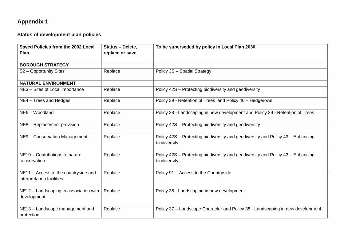
Appendix 1
Status of development plan policies
Saved Policies from the 2002 Local
Plan
Status – Delete,
replace or save
To be superseded by policy in Local Plan 2030
BOROUGH STRATEGY
S2 – Opportunity Sites
Replace Policy 3S – Spatial Strategy
NATURAL ENVIRONMENT
NE3 – Sites of Local importance Replace Policy 42S – Protecting biodiversity and geodiversity
NE4 – Trees and Hedges
Replace Policy 39 - Retention of Trees and Policy 40 – Hedgerows
NE6 – Woodland
Replace Policy 38 - Landscaping in new development and Policy 39 - Retention of Trees
NE8 – Replacement provision
Replace Policy 42S – Protecting biodiversity and geodiversity
NE9 – Conservation Management
Replace Policy 42S – Protecting biodiversity and geodiversity and Policy 43 – Enhancing
biodiversity
NE10 – Contributions to nature
conservation
Replace Policy 42S – Protecting biodiversity and geodiversity and Policy 43 – Enhancing
biodiversity
NE11 – Access to the countryside and
interpretation facilities
Replace Policy 91 – Access to the Countryside
NE12 – Landscaping in association with
development
Replace Policy 38 - Landscaping in new development
NE13 – Landscape management and
protection
Replace Policy 37 – Landscape Character and Policy 38 - Landscaping in new development

Saved Policies from the 2002 Local
Plan
Status – Delete,
replace or save
To be superseded by policy in Local Plan 2030
NE16 – Flooding
Replace Policy 92 – Flood Risk
NE18 – Character of built areas
Replace Policy 29 – Design quality and principles and Policy 35S – Green Infrastructure
NE20 – Landscape and environment
improvement
Replace Policy 37 – Landscape Character and Policy 38 - Landscaping in new development
NE24 – protection and enhancement of
water resources
Replace Policy 50S – Water resources
BUILT ENVIRONMENT
BE1 – Mixed uses
Replace Policy 29 – Design quality and principles
Policy 79 – Kempston district centre – new retail development,
Policy 82 – Local centres (including rural key service centres) – changes of use,
Policy 85 – Impact of town centre uses and
BE2 – Mixed use in opportunity sites
Delete Delete as relates to 2002 Opportunity sites
BE3 – Uses and infrastructure to
promote self-sustaining communities
Replace Policy 28S – Place making, Policy 58S – Affordable Housing, Policy 59S – Housing
Mix, Policy 86S – Delivering Infrastructure
BE4 – Mixed uses in residential areas
Replace Policy 30 – The impact of development – design impacts and Policy 31 – The impact
of development – access impacts
BE7 – Renewable energy – criteria
Replace Policy 55 – Renewable energy – district heating
Policy 56 – Renewable energy – broad locations suitable for renewable energy
development and
Policy 57 – Renewable energy – general impact

Saved Policies from the 2002 Local
Plan
Status – Delete,
replace or save
To be superseded by policy in Local Plan 2030
BE8 – Energy efficiency layouts
Replace Policy 54 – Energy efficiency
BE9 – Protecting the character of
Conservation Areas
Replace Policy 41S – Historic environment and heritage assets
BE11 – Setting of conservation areas
Replace Policy 41S – Historic environment and heritage assets
BE13 – Demolition of conservation
areas
Replace Policy 41S – Historic environment and heritage assets
BE15 – Protecting views and open
spaces
Replace Policy 28S – Place making and Policy 41S – Historic environment and heritage
assets
BE16 – new advertisements/shop fronts
in Conservation Areas
Replace Policy 34 – Advertisements and Policy 41S – Historic environment and heritage
assets
BE18 – Demolition of listed buildings
Replace Policy 41S – Historic environment and heritage assets
BE19 – Alterations to listed buildings
Replace Policy 41S – Historic environment and heritage assets
BE20 – change of use of listed
buildings
Replace Policy 41S – Historic environment and heritage assets
BE21 – Setting of listed buildings
Replace Policy 41S – Historic environment and heritage assets
BE22 – Recording of listed buildings
Replace Policy 41S – Historic environment and heritage assets
BE23 – Archaeology
Replace Policy 41S – Historic environment and heritage assets
BE24 – Archaeology
Replace Policy 41S – Historic environment and heritage assets

Saved Policies from the 2002 Local
Plan
Status – Delete,
replace or save
To be superseded by policy in Local Plan 2030
BE25 – Archaeology
Replace Policy 41S – Historic environment and heritage assets
BE26 – Historic Parks and Gardens
Replace Policy 41S – Historic environment and heritage assets
BE27 – Barn Conversions Replace Policy 65 – Reuse of rural buildings in the countryside
BE28 – New Agricultural Buildings
Replace Policy 65 – Reuse of rural buildings in the countryside
BE29 – High Standard of Design
Replace Policy 28S – Place making and
Policy 29 – Design quality and principles
BE30 – Material considerations in the
control of new development
Replace Policy 29 – Design quality and principles
BE31 – Statement of design principles
Replace Policy 29 – Design quality and principles
BE32 – Development on the edge of
urban areas and villages
Replace Policy 3S – Spatial Strategy
BE34 – Development adjoining main
road and rail routes
Replace Policy 38 - Landscaping in new development
BE35 – Achieving quality in residential
layouts
Replace Policy 29 – Design quality and principles
BE36 – Space about buildings
Replace Policy 30 – The impact of development – design impacts
BE37 – Overdevelopment
Replace Policy 30 – The impact of development – design impacts
BE38 – Landscaping Replace Policy 38 – Landscaping in new development
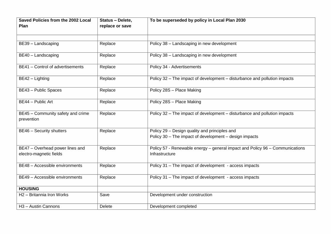
Saved Policies from the 2002 Local
Plan
Status – Delete,
replace or save
To be superseded by policy in Local Plan 2030
BE39 – Landscaping
Replace Policy 38 – Landscaping in new development
BE40 – Landscaping
Replace Policy 38 – Landscaping in new development
BE41 – Control of advertisements
Replace Policy 34 - Advertisements
BE42 – Lighting
Replace Policy 32 – The impact of development – disturbance and pollution impacts
BE43 – Public Spaces Replace Policy 28S – Place Making
BE44 – Public Art
Replace Policy 28S – Place Making
BE45 – Community safety and crime
prevention
Replace Policy 32 – The impact of development – disturbance and pollution impacts
BE46 – Security shutters
Replace Policy 29 – Design quality and principles and
Policy 30 – The impact of development – design impacts
BE47 – Overhead power lines and
electro-magnetic fields
Replace Policy 57 - Renewable energy – general impact and Policy 96 – Communications
Infrastructure
BE48 – Accessible environments
Replace Policy 31 – The impact of development - access impacts
BE49 – Accessible environments
Replace Policy 31 – The impact of development - access impacts
HOUSING
H2 – Britannia Iron Works
Save Development under construction
H3 – Austin Cannons Delete Development completed

Saved Policies from the 2002 Local
Plan
Status – Delete,
replace or save
To be superseded by policy in Local Plan 2030
H5 - College Street Kempston
Delete Development completed
H6 – Biddenham Loop
Save Development under construction
H7 – Land west of Kempston
Save Development under construction
H8 – Land north of Bromham Road,
Biddenham
Save Development under construction
H9 – Land at Shortstown
Save Development under construction
H10A – land north of Brickhill
Delete Development completed
H10b – Land north of Norse Road
Delete Development completed
H11 – Land south of Fields Road,
Wootton
Save Development under construction
H12 – Land north of Fields Road,
Wootton
Save Development under construction
H13 – Land off Rousebury Road,
Stewartby
Save Development under construction
H14 – Elstow Storage Depot
Save Development under construction
H18 – New Road, Great Barford
Delete Development completed.
H23 – Housing in second order villages Save

Saved Policies from the 2002 Local
Plan
Status – Delete,
replace or save
To be superseded by policy in Local Plan 2030
H24 – Residential development in SPA
villages
Replace Policy 5S – Development in villages with a Settlement Policy Area
H26 – Housing in the Open Countryside
Replace Policy 7S – Development in the countryside
H27 – Agricultural Workers Dwellings
Replace Policy 68 – Accommodation for rural workers
H28 – Replacement dwellings in the
open countryside
Replace Policy 66 – The replacement and extension of dwellings in the countryside
H29 – Extensions to dwellings in the
open countryside
Replace Policy 30 – The impact of development – design impacts and Policy 66 – The
replacement and extension of dwellings in the countryside
H34 – Mobility housing
Replace Policy 59S – Housing mix
H37 – Mobile homes Replace Policy 59S – Housing mix
H38 – changes to existing dwellings
and the development of garden land
Replace Policy 30 - The impact of development – design impacts, Policy 31 - The impact of
development – access impacts, Policy 32 - The impact of development – disturbance
and pollution impacts, and Policy 33 - The impact of development – infrastructure
impacts.
H39 – loss of residential stock
Delete No longer needed.
EMPLOYMENT AND TOURISM
E2 – Land south of Cambridge Road
Save Part of site remains to be developed
E5 – Land east of B530
Delete Development completed
E9 – Coronation Brickworks Delete Development completed

Saved Policies from the 2002 Local
Plan
Status – Delete,
replace or save
To be superseded by policy in Local Plan 2030
E10 – Elstow Brickworks
Save Wixams development under construction
E11 – Thurleigh Airfield
Delete Policy 70 – Key Employment Sites
E13 – Redevelopment of employment
sites
Replace Policy 70 – Key employment sites
Policy 71 – Other employment sites
E14 – Working from home Delete No longer needed
E15 – Business uses in residential
areas
Delete No longer needed
E16 – Premises for small businesses
Delete No longer needed
E17 – Business use within SPAs
Replace Policy 5S - Development in villages with a Settlement Policy Area
E18 – Re-use of rural buildings
Replace Policy 65 – Reuse of rural buildings in the countryside
E19 – Loss of employment sites in the
countryside/rural settlements
Replace Policy 70 Key employment sites
Policy 71 – Other employment sites
E20 – Intensification on existing
employment sites
Replace Policy 29 - Development quality and principles
E21 – Farm diversification
Delete No longer needed
E22 – Equestrian development
Replace Policy 30 –The impacts of development –design impacts
Policy 31 –The impacts of development – access impacts
Policy 32 – The impacts of development – disturbance and pollution impacts

Saved Policies from the 2002 Local
Plan
Status – Delete,
replace or save
To be superseded by policy in Local Plan 2030
Policy 33 - The impacts of development – infrastructure impacts
E23 – Encouraging tourism
Replace Policy 76 – Improvement and provision of new visitor facilities
E24 – Provision of signposting
Delete No longer needed
E25 – Tourist accommodation
Replace Policy 76 – Improvement and provision of new visitor accommodation
E26 – Touring caravans
Replace Policy 76 – Improvement and provision of new visitor accommodation
E27 – Static caravans/chalets
Replace Policy 76 – Improvement and provision of new visitor accommodation
SHOPPING
SH7 – New local shopping facilities
Replace Policy 81 – New shops in local centres
SH11 – Farm shops
Delete No longer needed
SH12 – Comparison retail outside
primary and district centre areas
Replace Reference in paragraph 11.47
SH13 – Comparison retail – type of
goods and sub-division
Replace Reference in paragraph 11.47
SH16 – New convenience retail
development
Replace Reference in paragraph 11.47
SH17 – New convenience retail
development
Replace Reference in paragraph 11.47
SH19 – Restaurants and take-aways
Replace Policy 81 – New shops in local centres

Saved Policies from the 2002 Local
Plan
Status – Delete,
replace or save
To be superseded by policy in Local Plan 2030
SH20 – Amusement centres
Replace Policy 85 – Impact of town centre uses
BEDFORD TOWN CENTRE
TC8 – Town centre residential use
Replace Policy 15 – Town centre uses
TRANSPORT
T3 – Strategic routes in the rural area
Delete Policy related to the A421 which has been completed.
T4 – Reducing highway impact
Replace Policy 32 – The impact of development – disturbance and pollution impacts
T6 – Public transport infrastructure
Replace Policy 87– Public transport
Policy 90S – Transport Infrastructure and network improvements
T7 – Developer contributions for public
transport measures
Replace Policy 86S - Delivering Infrastructure
Policy 87 – Public transport
T8 – Rail network
Replace Policy 90S – Transport infrastructure and network improvements
T9 – Rail services
Replace Policy 90S Transport infrastructure and network improvements
T10 – Access to rail stations and
services
Replace Policy 90S - Transport infrastructure and network improvements
T11 – Rail freight links
Delete No longer needed
T12 – River boat services
Delete No longer needed
T15 – Parking
Replace Policy 31 – The impact of development – access impacts
T19 – Coach parking
Delete No longer needed

Saved Policies from the 2002 Local
Plan
Status – Delete,
replace or save
To be superseded by policy in Local Plan 2030
T20 – Safety and traffic calming
Replace Policy 31 – The Impact of development – access impacts
T21 – Accessibility for less mobile
people
Replace Policy 31 – The impact of development – access impacts
LEISURE AND RECREATION
LR1 - New sports and leisure facilities
Replace Policy 97 – New sports and leisure facilities
LR2 – Adverse effects of development
Replace Policy 32 – The impact of development – disturbance and pollution impacts
LR3 – Golf
Replace Policy 97 – New sports and leisure facilities
LR4 – Rowing course
Save Development started.
LR5 – Radwell Lakes
Delete No longer needed
LR6 – Arts venue
Replace Policy 85 – Impact of Town Centre Uses
LR7 – Use of River Great Ouse
Replace Policy 44 – River Great Ouse
LR8 – Riverside Close amenity space
Delete Replaced by Policy AD43
LR9 – Moorings
Replace Policy – River Great Ouse
LR10 – Access to countryside
Replace Policy 91 – Access to the countryside
LR11 – Noise generation
Replace Policy 97 – New sports and leisure facilities
LR12 – Santa Pod Raceway
Replace Policy 97 – New sports and leisure facilities

Saved Policies from the 2002 Local
Plan
Status – Delete,
replace or save
To be superseded by policy in Local Plan 2030
LR13 – Loss of leisure facilities
Replace Policy 99 – Loss of existing sports and community facilities
LR14 – Playing fields and allotments
Replace Policy 99 – Loss of existing sports and community facilities
LR18 – Recreation/community uses
Replace Policy 99 – Loss of existing sports and community facilities
LR19 – Provision of new community
facilities
Replace Policy 98 – New community facilities
UTILITIES AND TELECOMS
U2 – Floodplain
Replace Policy 92 – Flood risk and
Policy 93 – Sustainable drainage systems
U3 – Waste water management
Replace Policy 86S – Delivering infrastructure
U4 – Satellite dishes etc
Replace Policy 95 – Domestic equipment
U5 – Telecommunications equipment Replace Policy 94 – Broadband and
Policy 96 – Communications Infrastructure

Core Strategy and Rural Issues Plan
Policies (2008)
Status – Delete,
replace or save
To be superseded by policy in Local Plan 2030
CP1 – Spatial strategy
Replace Policy 3S – Spatial strategy
CP2 – Sustainable development
principles
Replace Policy 37 – Landscape character
Policy 41S - Historic environment and heritage assets
Policy 42S - Protecting biodiversity and geodiversity
Policy 46S - Use of previously developed land and use of undeveloped land
Policy 51S – Climate change strategic approach
Policy 87 – Public transport
Policy 97 - New sports and leisure facilities
CP3 – The location of development in
the Growth Area
Replace Policy 3S – Spatial Strategy
CP4 – Key service centres in the
Growth Area
Replace Policy 4S – Amount and distribution of housing development
CP5 – Sequential approach to the
allocation of land for residential and
employment Development in the
Growth Area
Replace Policy 3S – Spatial Strategy and
Policy 4S – Amount and distribution of housing development
CP6 – The scale and pace of housing
development in the Growth Area
Replace Policy 4S – Amount and distribution of housing development
CP7 – Meeting housing needs
Replace Policy 4S – Amount and distribution of housing development
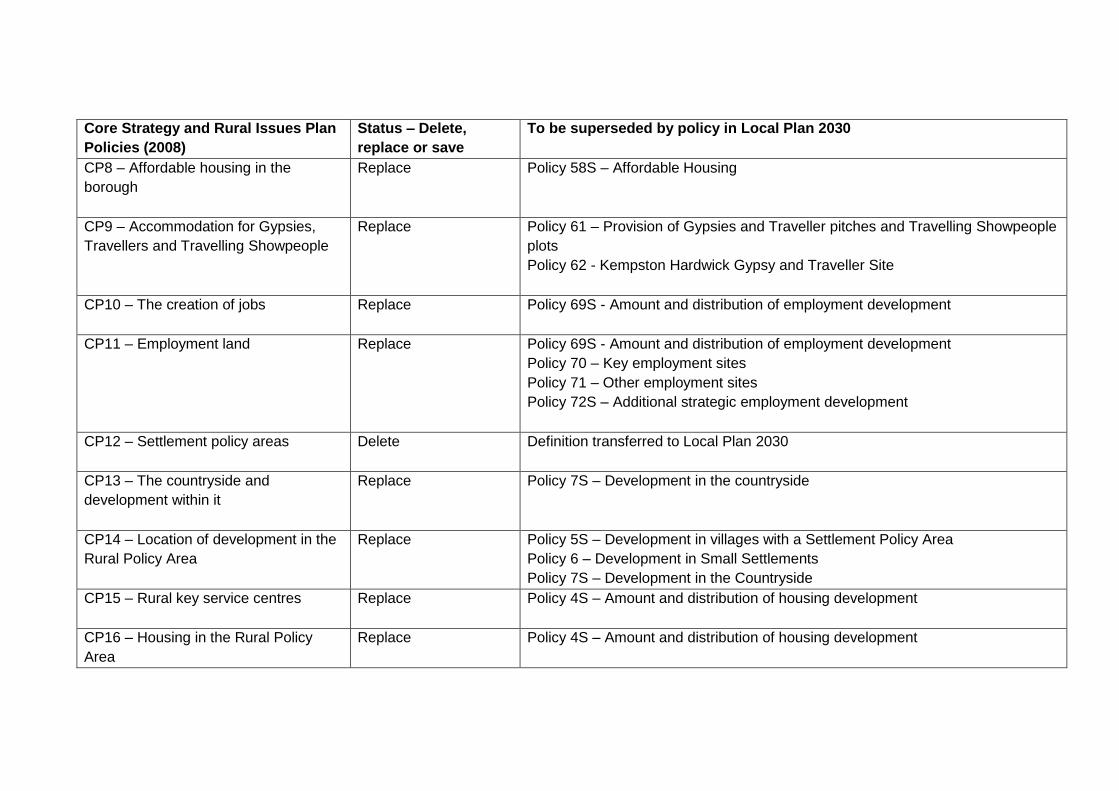
Core Strategy and Rural Issues Plan
Policies (2008)
Status – Delete,
replace or save
To be superseded by policy in Local Plan 2030
CP8 – Affordable housing in the
borough
Replace Policy 58S – Affordable Housing
CP9 – Accommodation for Gypsies,
Travellers and Travelling Showpeople
Replace Policy 61 – Provision of Gypsies and Traveller pitches and Travelling Showpeople
plots
Policy 62 - Kempston Hardwick Gypsy and Traveller Site
CP10 – The creation of jobs
Replace Policy 69S - Amount and distribution of employment development
CP11 – Employment land
Replace Policy 69S - Amount and distribution of employment development
Policy 70 – Key employment sites
Policy 71 – Other employment sites
Policy 72S – Additional strategic employment development
CP12 – Settlement policy areas
Delete Definition transferred to Local Plan 2030
CP13 – The countryside and
development within it
Replace Policy 7S – Development in the countryside
CP14 – Location of development in the
Rural Policy Area
Replace Policy 5S – Development in villages with a Settlement Policy Area
Policy 6 – Development in Small Settlements
Policy 7S – Development in the Countryside
CP15 – Rural key service centres
Replace Policy 4S – Amount and distribution of housing development
CP16 – Housing in the Rural Policy
Area
Replace Policy 4S – Amount and distribution of housing development

Core Strategy and Rural Issues Plan
Policies (2008)
Status – Delete,
replace or save
To be superseded by policy in Local Plan 2030
CP17 – Affordable housing to meet
local needs in the rural area
Replace Policy 67 – Affordable housing to meet local needs in the rural area
CP18 – Sustaining the local economy
and services
Replace Policy 75 – New employment development in the countryside
Policy 82 – Local centres (including rural key service centres) – changes of use
Policy 83 – Neighbourhood centres and individual shops – changes of use
Policy 98 – New community facilities
CP19 – Bedford town centre
Replace Policy 77S – Hierarchy of town centres
CP20 – Retail hierarchy
Replace Policy 77S – Hierarchy of town centres
CP21 – Designing in quality
Replace Policy 29 – Design quality and principles
CP22 – Green infrastructure
Replace Policy 35S – Green Infrastructure
CP23 – Heritage
Replace Policy 41S – Historic Environment & Heritage Assets
CP24 – Landscape protection and
enhancement
Replace Policy 37 – Landscape character
CP25 – Biodiversity
Replace Policy 42S – Protecting biodiversity and geodiversity and Policy 43 – Enhancing
biodiversity
CP26 – Climate change and pollution
Replace Policy 51S – Climate change strategic approach

Core Strategy and Rural Issues Plan
Policies (2008)
Status – Delete,
replace or save
To be superseded by policy in Local Plan 2030
CP27 – Strategic transport
infrastructure
Replace Policy 90S – Transport infrastructure and network improvements
CP28 – Local Transport Plan
Replace Policy 90S – Transport infrastructure and network improvements
CP29 – Accessibility
Replace Policy 90S – Transport infrastructure and network improvements
CP30 – Developer contributions
Replace Policy 86S - Delivering infrastructure
CP31 – Plan monitor and manage
Delete No longer needed
Town Centre Area Action Plan
Policies (2008)
Status – Delete,
replace or save
To be superseded by policy in Local Plan 2030
TC1 Definition of the town centre
Replace Policy 15 – Town Centre Areas
TC2 Improving the retail offer
Replace Policy 15 – Town centre uses
TC3 Primary shopping area and primary
shopping frontages
Replace Policy 15 – Town centre uses
TC4 Secondary shopping frontages
Replace Policy 15 – Town centre uses
TC5 Office development
Replace Policy 15 – Town centre uses

Town Centre Area Action Plan
Policies (2008)
Status – Delete,
replace or save
To be superseded by policy in Local Plan 2030
TC6 Office development sites
Replace Policy 85 – Impact of town centre uses
TC7 New retail quarter Bedford Town
Centre West
Replace Delete as completed
TC8 New retail quarter ~ retail
reinvestment and the High Street
Replace Policy 15 – Town centre uses and
Policy 16 – Bedford High Street
TC9 Cultural quarter ~ Castle Lane
Delete Development completed
TC10 Cultural quarter ~ Cecil Higgins
Art Gallery & Bedford Museum
Delete Development completed
TC11 Riverside quarter Riverside Square
Delete Development completed
TC12 Riverside quarter Shire Hall and
the Bank building site
Replace Policy 16 – Bedford High Street and
Policy 17 – Riverside development
TC13 Station quarter Bedford Station
Replace Policy 10 – The station area, Ashburnham Rd, Bedford
TC14 St Mary's quarter
Replace Policy 17 – Riverside development
TC15 Kingsway quarter
Replace Policy 14 – Land south of the river, Bedford
TC16 Land at Lime Street
Delete No longer needed

Town Centre Area Action Plan
Policies (2008)
Status – Delete,
replace or save
To be superseded by policy in Local Plan 2030
TC17 Progress Ford The Broadway
Delete No longer needed
TC18 Junction/ network improvements
2006-2011
Replace Policy 90S – Transport infrastructure and network improvements
TC19 Network improvements post 2011
Replace Policy 90S – Transport infrastructure and network improvements
TC20 Development related network
improvements
Replace Policy 90S – Transport infrastructure and network improvements
TC21 Walking and cycle routes
Replace Policy 17 – Riverside development
Policy 31 – The impact of development- access impacts
TC22 Pedestrian connections
Replace Policy 17 – Riverside development
Policy 31 – The impact of development- access impacts
TC23 Public transport
interchange/services
Replace Policy 87 – Public transport
TC24 Parking
Replace Policy 31 – The impact of development- access impacts
TC25 Housing mix
Replace Policy 59S – Housing mix
TC26 Living over the shop
Replace Policy 15 –Town centre uses
TC27 Heritage
Replace Policy 41S – Historic environment and heritage assets
TC28 Tourism Replace Policy 79 – Improvement and provision of new visitor accommodation

Town Centre Area Action Plan
Policies (2008)
Status – Delete,
replace or save
To be superseded by policy in Local Plan 2030
TC29 Riverside frontages
Replace Policy 17 - Riverside development
TC30 Riverside development
Replace Policy 17 - Riverside development
TC31 Biodiversity
Replace Policy 42S – Protecting biodiversity and geodiversity and Policy 43 – Enhancing
biodiversity
TC32 Public spaces
Replace Policy 15 – Town Centre uses
TC33 Shop fronts
Replace Policy 29 – Design quality and principles and Policy 34 – Advertisements
TC34 Town centre management
Delete No longer needed
TC35 Town centre amenity
Replace Policy 30 –The impacts of development –design impacts
Policy 31 –The impacts of development – access impacts
Policy 32 – The impacts of development – disturbance and pollution impacts
Policy 33 - The impacts of development – infrastructure impacts
TC36 Redevelopment proposals
Replace Policy 8 – Key development sites in St Paul’s Square, Bedford
TC37 Leisure uses
Replace Policy 15 – Town centre uses
TC38 Compulsory purchase
Delete No longer needed
TC39 Urban design principles
Replace Policy 29 – Design quality and principles

Town Centre Area Action Plan
Policies (2008)
Status – Delete,
replace or save
To be superseded by policy in Local Plan 2030
TC40 Developer contributions
Replace Policy 86S – Delivering infrastructure
TC41 Submission requirements
Delete No longer needed
Allocations and Designations Local
Plan Policies (2013)
Status – Delete,
replace or save
Proposed policy in Local Plan 2030
AD1 Sustainable Development Policy
Save
AD2 Sustainable Design and
Construction
Replace Policy 54 – Energy efficiency
AD3 Land at Hall End Road, Wootton
Save
AD4 Land at Old Ford End Road,
Queens Park, Bedford
Save
AD5 Wixams Northern Expansion
Delete No longer needed (de-allocated, permission granted for employment use)
AD6 Land South of Ford End Road,
Bedford
Replace Policy 12 – Land at Ford End Road, Bedford
AD7 Land East of Eastcotts Road,
Bedford
Save

Allocations and Designations Local
Plan Policies (2013)
Status – Delete,
replace or save
Proposed policy in Local Plan 2030
AD8 Dallas Road, Kempston
Delete No longer needed (de-allocated)
AD9 St Bede’s School, Bedford
Delete Development completed
AD10 Lansdowne Road, Warwick
Avenue and Dynevor Road, Bedford
Save
AD11 Land at Medbury Farm, Elstow
Save
AD12 Land at Bell Farm, Kempston
Save
AD13 Marston Vale Innovation Park
Phase 2, Wootton
Save
AD14 Land at Cardington Cross, Bedford
Delete Development completed
AD15 Manton Lane Reservoir Site,
Bedford
Save
AD16 Land West of Manton Lane,
Bedford
Save
AD17 Land West of the B530, Kempston
Save
AD18 Land North of the A6-A428 Link
Road, Bedford
Save

Allocations and Designations Local
Plan Policies (2013)
Status – Delete,
replace or save
Proposed policy in Local Plan 2030
AD19 Land at Manton Lane, Bedford
Save
AD20 Land at Bedford Road, Great
Barford
Save Under construction
AD21 Land at Chawston Lake, Roxton
Road, Wyboston
Save
AD22 Land North of Ravensden Road,
Salph End, Renhold
Save
AD23 Bedford River Valley Park
Enabling Development
Save
AD24 Green Infrastructure Opportunity
Zones
Save
AD25 Forest of Marston Vale
Replace Policy 36S – Forest of Marston Vale
AD26 Bedford River Valley Park
Save
AD27 Bedford to Milton Keynes
Waterway Park
Save
AD28 Provision of Open Space and Built
Facilities in Association with New
Save

Allocations and Designations Local
Plan Policies (2013)
Status – Delete,
replace or save
Proposed policy in Local Plan 2030
Development
AD29 Kempston District Centre – new
retail facilities
Replace Policy 79 – Kempston district centre – new retail development
AD30 Kempston District Centre –
changes of use
Replace Policy 80 - Kempston District Centre – changes of use
AD31 Local Centres – new retail facilities
Replace Policy 84 – All shop units
AD32 Local Centres and Other Defined
Retail Centres
Replace Policy 82 – Local Centres (including rural key service centres) – changes of use
AD33 Individual Shops and Undefined
Retail Centres
Replace Policy 84 – All shop units
AD34 All Shop Units
Replace Policy 84 – All shop units
AD35 Road Schemes Replace Policy 90S – Transport infrastructure and network improvements
AD36 Pedestrian Routes
Save
AD37 Park and Ride Facilities
Delete
AD38 Commercial Vehicle Parking and
Motorists Facilities
Save
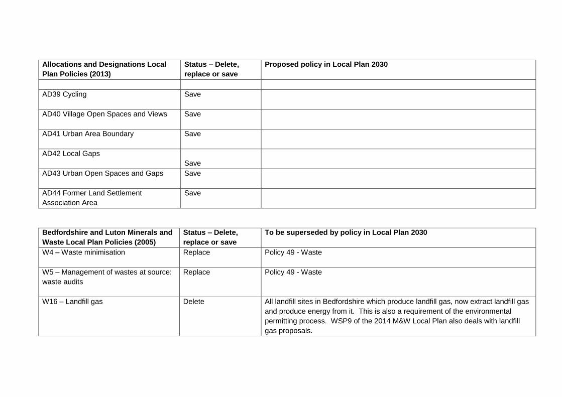
Allocations and Designations Local
Plan Policies (2013)
Status – Delete,
replace or save
Proposed policy in Local Plan 2030
AD39 Cycling
Save
AD40 Village Open Spaces and Views
Save
AD41 Urban Area Boundary
Save
AD42 Local Gaps
Save
AD43 Urban Open Spaces and Gaps
Save
AD44 Former Land Settlement
Association Area
Save
Bedfordshire and Luton Minerals and
Waste Local Plan Policies (2005)
Status – Delete,
replace or save
To be superseded by policy in Local Plan 2030
W4 – Waste minimisation
Replace Policy 49 - Waste
W5 – Management of wastes at source:
waste audits
Replace Policy 49 - Waste
W16 – Landfill gas
Delete All landfill sites in Bedfordshire which produce landfill gas, now extract landfill gas
and produce energy from it. This is also a requirement of the environmental
permitting process. WSP9 of the 2014 M&W Local Plan also deals with landfill
gas proposals.

Bedfordshire and Luton Minerals and
Waste Local Plan Policies (2005)
Status – Delete,
replace or save
To be superseded by policy in Local Plan 2030
W17 – Land raising
Save Also relevant is Policy 48 – Minerals and waste restoration policy
W22 – Safeguarding existing sites
Save
GE1 – Matters to be addressed in
planning applications
Delete
GE2 – Restoration/improvement of
Marston Vale
Replace Policy 36S – Forest of Marston Vale
GE3 – Environmental Improvement of
the Greensand Trust area
Not relevant to Bedford borough
GE4 – Environmental Improvement of
Ivel and Ouse Valleys (The Ivel and
Ouse Countryside Project)
Not relevant to Bedford borough
GE5 – Protection of Green Belt Land
Nor relevant to Bedford borough
GE6 – Protection of Best and Most
Versatile agricultural land
Replace Policy 46S – Use of previously developed land and use of undeveloped land
GE7 – Protection of the Chilterns Area of
Outstanding Natural Beauty (AONB)
Nor relevant to Bedford borough
GE8 – Protection of AGLV Delete No longer needed

Bedfordshire and Luton Minerals and
Waste Local Plan Policies (2005)
Status – Delete,
replace or save
To be superseded by policy in Local Plan 2030
GE9 – Landscape protection and
landscaping
Replace Policy 38 – Landscaping in new development
GE10 – Protection/enhancement of trees
and woodland
Replace Policy 39 – Retention of trees
GE11 – Protection of sites of national
nature conservation importance
Replace Policy 42S – Protecting biodiversity and geodiversity
GE12 – Protection of locally designated
nature conservation sites, regionally
important geological/geomorphological
sites (RIGS) and undesignated sites of
significant conservation interest
Replace Policy 42S – Protecting biodiversity and geodiversity
GE13 – Species of Habitat Protection
and Enhancement
Replace Policy 43 – Enhancing biodiversity
GE14 – Archaeology
Replace Policy 41S – Historic environment and heritage assets
GE15 – Statutorily designated Historic
Buildings and Sites
Replace Policy 41S – Historic environment and heritage assets
GE16 – Local Historic Buildings,
Conservation Areas and Historic
Replace Policy 41S – Historic environment and heritage assets

Bedfordshire and Luton Minerals and
Waste Local Plan Policies (2005)
Status – Delete,
replace or save
To be superseded by policy in Local Plan 2030
Environment Sites
GE17 – Pollution control
Replace Policy 47S – Pollution, disturbance and contaminated land
GE18 – Disturbance
Replace Policy 47S – Pollution, disturbance and contaminated land
GE19 – Flooding
Replace Policy 92 – Flood Risk
GE20 – Water resources
Replace Policy 50S – Water resources
GE21 – Public Rights of Way
Replace Policy 91 – Access to the countryside
GE22 – Transport: alternative means
Replace Policy 30 –The impacts of development –design impacts
Policy 31 –The impacts of development – access impacts
Policy 32 – The impacts of development – disturbance and pollution impacts
Policy 33 - The impacts of development – infrastructure impacts
GE23 – Transport: suitability of local
road network
Replace Policy 88 – Impact of transport on people, places and environment
GE24 – Ancillary minerals and waste
developments
Replace Policy 48 – Minerals and waste restoration policy
GE25 – Buffer zones
Replace Policy 47S – Pollution, disturbance and contaminated land
GE26 – Restoration
Replace Policy 48 – Minerals and waste restoration policy
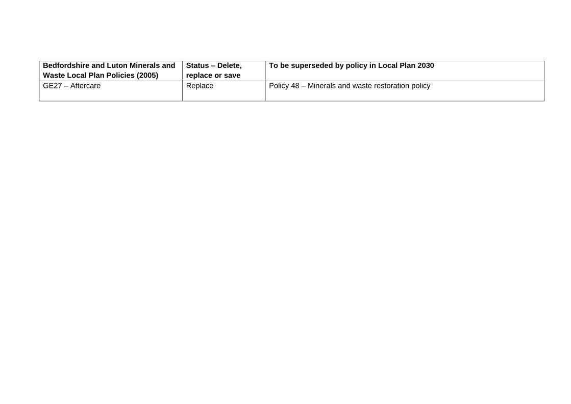
Bedfordshire and Luton Minerals and
Waste Local Plan Policies (2005)
Status – Delete,
replace or save
To be superseded by policy in Local Plan 2030
GE27 – Aftercare
Replace Policy 48 – Minerals and waste restoration policy

Appendix 2
Strategic Policies
The strategic policies of the local plan are distributed throughout this document and can be found within the relevant chapters. In order to distinguish them, they are given an “S” suffix after the policy number. The following table lists the strategic policies.
Policy Strategic policy name Chapter
2S Healthy communities Health
3S Spatial strategy Strategy
4S Amount and distribution of housing development Strategy
5S Development in villages with a Settlement Policy Area Strategy
7S Development in the countryside Strategy
28S Place making Place making
35S Green infrastructure Place making
36S Forest of Marston Vale Place making
41S Historic environment and heritage assets Place making
42S Protecting biodiversity and geodiversity Place making
46S Use of previously developed land and use of undeveloped land Resources and climate change
47S Pollution, disturbance and contaminated land Resources and climate change
50S Water resources Resources and climate change
51S Climate change strategic approach Resources and climate change
58S Affordable housing Places and allocations
59S Housing mix Places and allocations
69S Amount and distribution of employment development Economy
72S Additional strategic employment development Economy
77S Hierarchy of town centres Economy
86S Delivering Infrastructure Plan Implementation and Infrastructure Delivery
90S Transport infrastructure and network improvements Plan Implementation and Infrastructure Delivery

Appendix 3
All local plan policies
Policy number Policy name
1S Reviewing the Local Plan 2030
2S Healthy communities
3S Spatial strategy
4S Amount and distribution of housing development
5S Development in villages with a Settlement Policy Area
6 Development in Small Settlements
7S Development in the countryside
8 Key development sites in St Paul’s Square
9 Land at Duckmill Lane / Bedesman Lane, Bedford
10 The station area, Ashburnham Rd, Bedford
11 Greyfriars, Bedford
12 Land at Ford End Road, Bedford
13 Land at Borough Hall, Bedford
14 Land south of the river, Bedford
15 Town centre uses
16 Bedford High Street
17 Riverside development
18 Land at Gold Lane, Biddenham
19 Land at 329 Bedford Road, Kempston
20 Land at Mowbray Road, Bedford
21 Land north of Beverley Crescent, Bedford
22 Land at Lodge Hill, Bedford
23 Land to the rear of Bromham Road, Biddenham
24 Land at Grazehill, Bedford
25 Former Stewartby Brickworks
26 Opportunity Sites
27 Land north of School Lane, Roxton
28S Place making
29 Design quality and principles
30 The impact of development – design impacts
31 The impact of development – access impacts

Policy number Policy name
32 The impact of development – disturbance and pollution impacts
33 The impact of development – infrastructure impacts
34 Advertisements
35S Green infrastructure
36S Forest of Marston Vale
37 Landscape character
38 Landscaping in new development
39 Retention of trees
40 Hedgerows
41S Historic environment and heritage assets
42S Protecting biodiversity and geodiversity
43 Enhancing biodiversity
44 River Great Ouse
45 Local Green Space
46S Use of previously developed land and use of undeveloped land
47S Pollution, disturbance and contaminated land
48 Minerals and waste restoration policy
49 Waste
50S Water resources
51S Climate change strategic approach
52 Water demand
53 Development layout and accessibility
54 Energy efficiency
55 Renewable energy – district heating
56 Renewable energy – broad locations suitable for renewable energy development
57 Renewable energy – general impact
58S Affordable housing
59S Housing mix
60 Specialist housing
61 Provision of Gypsy and Traveller pitches and Travelling Showpeople plots
62 Kempston Hardwick Gypsy and Traveller site
63 Proposals for Traveller sites on unallocated land in the countryside
64 Design of Gypsy, Traveller and Travelling Showpeople sites
65 Reuse of rural buildings in the countryside
66 The replacement and extension of dwellings in the countryside
67 Affordable housing to meet local needs in the rural area

Policy number Policy name
68 Accommodation for rural workers
69S Amount and distribution of employment development
70 Key employment sites
71 Other employment sites
72S Additional strategic employment development
73 Wyboston Lakes
74 Employment skills
75 New employment development in the countryside
76 Improvement and provision of new visitor accommodation
77S Hierarchy of town centres
78 Out of centre development
79 Kempston district centre – new retail development
80 Kempston district centre – changes of use
81 New shops in local centres
82 Local centres (including rural key service centres) – changes of use
83 Neighbourhood centres and individual shops – changes of use
84 All shop units
85 Impact of town centre uses
86S Delivering infrastructure
87 Public transport
88 Impact of transport on people, places and environment
89 Electric vehicle infrastructure
90S Transport infrastructure and network improvements
91 Access to the countryside
92 Flood risk
93 Sustainable drainage systems (SuDS)
94 Broadband
95 Domestic equipment
96 Communications infrastructure
97 New sports and leisure facilities
98 New community facilities
99 Loss of existing sports and community facilities

Appendix 4
Affordable Housing Commuted Sum Calculation The commuted sum will be based upon the difference between the open market value of the property and the estimated revenues that would have been paid by a Registered Provider for commensurate off-site provision. Sums will be calculated to two decimal places. 1. Calculation of Commensurate Provision
The Council’s affordable housing requirement is 30%. With off-site provision of affordable housing the actual development (which is entirely market housing) equates to 70% of a notional development which does provide affordable housing. The affordable housing requirement for the purposes of determining a commuted sum is therefore assessed as follows: the number of dwellings in the actual scheme x 100 = calculation base for affordable housing requirement
70
2. Dwelling Mix for Affordable Housing:
The assumed dwelling mix for affordable housing will be: For schemes that are predominantly houses: 50% 2 Bedroom Houses (72m2) 50% 3 Bedroom Houses (82m2) For schemes that are predominantly flats: 34% 1 Bedroom Flats (40m2) 66% 2 Bedroom Flats (62m2)
3. Tenure Balance:
The assumed tenure balance for the affordable housing will be:
Affordable Rent 78% Shared Ownership 22%
4. Affordable Housing Revenue Assumptions:
Revenue assumptions for the affordable housing will be:

Affordable Rent: Gross rent 80% of open market rent less management costs 30% Capitalised at 6%.
Shared Ownership: Purchase share 40% of open market value Rent Income 2.75% of unsold equity Rents Capitalised at 6.5%
Worked Example: 1. Example Scheme:
Number of dwellings on site: 14 dwellings Dwelling types: predominantly houses Open market rent – 2 bed house £600 per month Open market rent – 3 bed house £750 per month Open market value – 2 bed house £220,000 Open market value – 3 bed house £300,000
2. Commensurate Provision:
A scheme of 14 dwellings would generate a requirement for 4.2 affordable dwellings on-site but the same scheme would generate a
requirement for 6 affordable dwellings as the basis of the commuted sum calculation. i.e.:
14 (dwellings) x 100 = 20 dwellings x 30% = 6 affordable units required
70
3. Affordable Housing Scheme Mix:
Number of houses for Affordable Rent: 6 (dwellings) x 78% = 4.68 dwellings for Affordable Rent. Of which 50% are 2 bedroom houses and 50% are 3 bedroom houses:

Affordable Rent dwelling mix therefore:
2 bedroom houses for affordable rent: 6 (dwellings) x 78% x 50% (2 bed houses) = 2.34 2BH
3 bedroom houses for affordable rent: 6 (dwellings) x 78% x 50% (3 bed houses) = 2.34 3BH
Number of houses for Shared Ownership: 6 (dwellings) x 22% = 1.32 dwellings for Shared Ownership
Of which 50% are 2 bedroom houses and 50% are 3 bedroom houses: Shared Ownership dwelling mix therefore:
2 bedroom houses for shared ownership 6 (dwellings) x 22% x 50% (2 bed houses) = 0.66 2BH
3 bedroom houses for shared ownership 6 (dwellings) x 22% x 50% (3 bed houses) = 0.66 3BH
4. Total Open Market Value of Market Housing
3 x 2 bedroom houses @ £220,000 £660,000
3 x 3 bedroom houses @ £300,000 £900,000
Total Open Market Value £1,560,000 (A)
5. Revenues From Registered Provider:
Affordable Rent:
2.34 (2 bed houses) x ((£600x80%x12) -30%) (net annual rent) = £ 9,434.88
2.34 (3 bed houses) x ((£750x80%x12) -30%) (net annual rent) = £11,793.60
Total £21,228.48
Capitalised at 6 % = £353,808.00 (B)
Shared Ownership:
a) Shared Ownership Sales Receipts:

0.66 (2 bed houses) x £220,000 x 40% (sales receipts) = £58,080
0.66 (3 bed houses) x £300,000 x 40% (sales receipts) = £79,200
Total shared ownership sales receipts £137,280 (C)
b) Shared Ownership Rents
0.66 (2 bed houses) x £220,000 (value) x 60% (unsold equity) x 2.75% (annual rent) = £2,395.80
0.66 (3 bed houses) x £300,000 (value) x 60% (unsold equity) x 2.75% (annual rent) = £3,267.00
Total shared ownership rents £5,662.80
Capitalised at 6.5 % = £87,120.00 (D)
c) Total Shared Ownership Revenue:
Sales Receipts £137,280.00 (C)
Capitalised Rent £ 87,120.00 (D)
Total Shared Ownership £224,400.00 (E)
Total revenues from Registered Provider:
Affordable Rent £353,808.00 (B)
Shared Ownership £224,400.00 (E)
Revenues from Registered Provider £578,208.00 (F)
6. Commuted Sum Calculation:
(Open Market Value less estimated revenues that would have been paid by a Registered Provider)
Total Open Market Value £1,156,000.00 (A)
Less Revenue from Registered Providers £ 578,208.00 (F)
Total Commuted Sum £577,792.00

Appendix 5
Glossary
Glossary Term Meaning
A1 Shops Shops, retail warehouses, hairdressers, undertakers, travel and ticket agencies, post offices, pet shops, sandwich
bars, showrooms, domestic hire shops, dry cleaners, funeral directors and internet cafes (See Town and Country
Planning (Use Classes) Order).
A2 Financial and Professional
Services
Financial services such as banks and building societies, professional services (other than health and medical
services) including estate and employment agencies. It does not include betting offices or pay day loan shops - these
are now classed as “sui generis” uses cafes (See Town and Country Planning (Use Classes) Order).
A3 Restaurants and Cafes For the sale of food and drink for consumption on the premises - restaurants, snack bars and cafes cafes (See Town
and Country Planning (Use Classes) Order).
A4 Drinking establishments Public houses, wine bars or other drinking establishments (but not night clubs) including drinking establishments with expanded food provision cafes (See Town and Country Planning (Use Classes) Order).
A5 Hot food takeaways For the sale of hot food for consumption off the premises cafes (See Town and Country Planning (Use Classes)
Order).
Air Quality Management Area
(AQMA)
An area where it has been determined that national air quality objectives are not likely to be achieved. An action plan
is prepared to address the issues.
Affordable Housing
This includes housing for social rent, affordable rent and intermediate housing provided to eligible households whose
needs are not met by the open market. Eligibility is determined with regard to local incomes and local house prices.
Allocations Sites specifically identified in the development plan and on the Policies Map for development.
Ancient Woodland Woodland sites which have had a continuous cover of native trees and plants since at least 1600AD.

Glossary Term Meaning
Bedford Borough Planning
Annual Monitoring Reports
Reports that monitor the progress and effectiveness of the policies in the development plan. Information is updated on
a regular basis.
B1 Business Offices (other than those that fall within A2 above), research and development of products and processes, light
industry appropriate in a residential area cafes (See Town and Country Planning (Use Classes) Order).
B2 General Industrial Use for industrial processes other than one falling within class B1above (excluding incineration purposes, chemical
treatment or landfill or hazardous waste) cafes (See Town and Country Planning (Use Classes) Order).
B8 Storage or Distribution. This class includes enclosed and open air storage cafes (See Town and Country Planning (Use Classes) Order).
Bedford and Milton Keynes
Waterway
A proposed new broad beam canal set in a green corridor that will link the Great Ouse in Kempston to the Grand
Union Canal in Milton Keynes, and connect the Fenland waterways to the central waterway network. The project is led
by a Consortium of local authorities including Bedford Borough Council, together with the Environment Agency,
Bedford & Milton Keynes Waterway Trust and others.
Bedford and Milton Keynes
Waterway Trust
A non-profit group established to promote the development of a waterway park to link the Grand Union Canal in Milton
Keynes to the River Great Ouse in Bedford.
Bedford River Valley Park An area to the east of Bedford designated on the Policies Map for a new area of multi-functional greenspace.
Bedford Waterspace Study
A joint study commissioned by Bedford Borough Council and the Environment Agency to produce a framework to
guide future development along the river corridor of the River Great Ouse from Old Bromham Bridge to Willington
Lock.
Bedford High Street
Townscape Heritage Initiative
A scheme to ensure the long term preservation of the Bedford High Street focusing on whole building schemes to
restore traditional shop fronts, bring upper floors back to productive use and carry out structural repairs on buildings.
This initiative was funded by the Heritage Lottery Fund, Bedford Borough Council and Bedford BID and resulted in the
restoration of 16 premises on the High Street.
Bedfordshire and Luton A framework for the delivery of the UK Biodiversity Action Plan for areas in Bedfordshire and Luton. It identifies

Glossary Term Meaning
Biodiversity Action Plan (2001) priorities and establishes a programme for the conservation of local and nationally important biodiversity.
Biodiversity The variety of life on earth or in a specified region or area.
Biomass Wood and other organic matter which is burned for fuel and to obtain energy.
Climate Change Long-term changes in temperature, precipitation, wind and all other aspects of the earth's climate. Often regarded as
a result of human activity and fossil fuel consumption.
Community Infrastructure Levy
(CIL)
A levy which local authorities in England and Wales may charge on most types of new development in their area. CIL
charges relate the amount of charge to the size and character of the development, together with the charging zone
within which it is located. The proceeds of the levy must be spent on infrastructure to support the development of the
area.
Commitment Where planning permission has been granted or there is a resolution to grant planning permission awaiting the
finalisation of a legal agreement. This term can also be used to describe existing development allocations.
Conservation Areas Under the Planning (Listed Buildings and Conservation Areas) Act 1990, local planning authorities are able to
designate as conservation areas any “areas of special architectural or historic interest, the character of which it is
desirable to preserve or enhance”.
Corporate Plan The Council’s plan for 2017-2021 which sets out actions to focus the Council’s work on helping to achieve the
potential of the borough. The plan includes four goals which are to support people, enhance places, create wealth and
empower communities.
Countryside Land outside Settlement Policy Areas and the built form of the defined Small Settlements.
County Wildlife Sites County Wildlife Sites (CWS) are recognised as sites of significant nature conservation interest outside the network of
statutorily protected wildlife areas (e.g. Sites of Special Scientific Interest (SSSIs)). The high wildlife value of many
CWS has developed through land management practices that have allowed wildlife to thrive e.g. traditional and
historical management such as rotational coppicing of woodland, hay cutting or grazing of grasslands. Some CWS are

Glossary Term Meaning
also designated as SSSIs.
Curtilage-listed Structures Those structures considered to have listed status in association with the principal listed building on the site in accordance with section 1(5) of the Planning (Listed Building and Conservation Areas) Act 1990. These will include any object or structure fixed to the building and any freestanding structures which form part of the land within the curtilage and have done so since July 1, 1948.
Discontinuance Notice An action where a local authority serves a notice requiring that the display of a particular advertisement with deemed
consent (which does not require planning permission) be discontinued.
Design Codes A set of specific rules or requirements to guide the physical development of a site or place. The aim of design coding
is to provide clarity as to what constitutes acceptable design quality and thereby provides a level of certainty for
developers and the local community alike that can help to facilitate the delivery of good quality new development.
Designations Areas shown on the Policies Map to which specific policies apply (not allocations). These may be areas where
development is prohibited or restricted.
Development Briefs Adopted by the Borough Council as a detailed statement of its planning policies for a particular site and its aspirations
in terms of uses, layout and design principles.
Development Plan Under the Planning Acts, this is the prime consideration in the determination of planning applications.
Forest of Marston Vale One of twelve community forests established throughout England by the Countryside Commission and Forestry
Authority. These multi-purpose forests on the edge of towns and cities will provide opportunities for recreation,
forestry, education and the creation of wildlife habitats.
Geodiversity The variety of rocks, fossils, minerals, landforms and soils along with the natural processes that shape the landscape.
Green Infrastructure A combination of natural and planned, accessible open spaces and amenity areas including recreation and sports
facilities, pathways and routes, natural and historic sites, canals and water spaces, accessible countryside and other
open areas that create a network and contribute to the character of towns and villages.

Glossary Term Meaning
Green Space Strategy
A document produced by Bedford Borough Council to assist in the future planning, management and investment in
high quality and publicly-accessible green space.
Green Wheel A vision to develop and enhance the existing network of traffic free paths and quiet routes around the Bedford urban
area for use by pedestrians, cyclists and horse riders where possible.
Green Flag An award scheme that recognises well managed parks and green spaces which meet standards for the management
of recreational outdoor space across the UK and the world.
Gypsy and Traveller Pitch A Gypsy and Traveller pitch is the space required to accommodate one household with their caravans, parking and
manoeuvring space and usually a day room.
Health Impact Assessment A tool to measure the potential health impacts of a proposed project or plan on the wider population. This assessment
is to appraise both the positive and negative impacts help to achieve better policies and developments.
Heritage Impact Assessment A document outlining the historic and/or archaeological significance of a building or landscape within its wider setting.
The document also includes an assessment of the proposed development on the setting of the heritage asset and a
mitigation strategy.
Heritage Statement An assessment of the significance of heritage assets and/or their settings affected by a development, and of the
impacts of that development upon them.
Historic Environment Record
An information source maintained by Bedford Borough Council for the whole borough covering historical assets such
as archaeological sites and finds, historic landscapes and historic buildings.
Infrastructure Delivery Plan
A plan outlining the future infrastructure requirements over the lifetime of the local plan to support future development.
Issues and Options The first stage of the local plan process whereby the public is consulted on a number of different spatial options for
the scope and detail of the Plan. Sometimes known as ‘Regulation 18’ consultation.
Joint Strategic Needs A local assessment prepared by the Bedford Borough Health and Wellbeing Board to assess the current and future

Glossary Term Meaning
Assessment
health and social care needs.
Key Service Centres Large villages with a good level of services identified in the Local Plan 2030 as Bromham, Clapham, Great Barford,
Sharnbrook, Shortstown; Wilstead, Wixams and Wootton.
Landscape Character
Assessment
A tool which can be used to understand the important features that make a landscape distinctive.
Landscape Sensitivity Study
Draws together information from the Landscape Character Assessment at a village scale.
Listed Buildings Under the Planning (Listed Buildings and Conservation Areas) Act 1990, the Secretary of State for Culture, Media and
Sport has a statutory duty to compile lists of buildings of special architectural or historic interest. Buildings are graded
I, II* or II to reflect their importance and permission is required for works which may affect their character as buildings
of special architectural or historic interest.
Local Green Space
Areas of special protection designated through a Local Plan or Neighbourhood Plan which meets the criteria set out in
the National Planning Policy Framework and is of particular significance to a local community.
Local Geological Site
A non-statutory designation that is considered worthy of protection for its scientific or education importance and its
landscape value in terms of geology.
Local Nature Reserves Areas of land which are of significant nature conservation value at the local level. A Local Nature Reserve is a
statutory designation.
Local Transport Plan A five-year strategy for the development of local, integrated transport, supported by a programme of transport
improvements. It is used to bid to government for funding transport improvements.
Mixed Use Development A development that promotes the integration and diversity of a number of land uses resulting in benefits such as
reducing the need to travel and deterring criminal activity by generating different activities at different times of the day.
National Infrastructure Provides the Government with expert, impartial advice on major long-term infrastructure challenges.

Glossary Term Meaning
Commission
Natura 2000 A Europe-wide network of sites of international importance for nature conservation established under the European
Community Directive on the Conservation of Natural Habitats and of Wild Fauna and Flora (92/43/EEC 'Habitats
Directive').
Natural Environment White
Paper
A government paper produced in 2011 outlining the government’s vision for the natural environment for the next 50
years and ways in which actions will help to achieve the vision.
National Planning Policy
Framework (NPPF)
National government policy for planning in England and how these are expected to be applied, introduced in 2012 and
updated 2018.
Neighbourhood Development
Order
An order that can grant planning permission for a specified area in a designated Neighbourhood Area. The granting of
an order is determined by the process outlined in the Neighbourhood Planning (General) Regulations 2012.
Neighbourhood Development
Plan
A plan prepared by a Parish Council or Neighbourhood Forum for a particular neighbourhood area (made under the
Planning and Compulsory Purchase Act 2004).
Non-designated Heritage
Assets
These are buildings, monuments, sites, places, areas or landscapes identified as having a degree of significance
meriting consideration in planning decisions but which are not formally designated heritage assets.
Objectively Assessed Need
An assessment of the development needs for housing (both market and affordable); and economic development
(which includes main town centre uses).
One Public Estate Programme
A national government funded programme which aims to encourage owners of public sector assets to make better
use of their land by working together to deliver economic growth, new homes, jobs and savings for the public sector.
Previously Developed Land Land which is or was occupied by a permanent structure, including the curtilage of the developed land (although it
should not be assumed that the whole of the curtilage should be developed) and any associated fixed surface
infrastructure. This excludes: land that is or has been occupied by agricultural or forestry buildings; land that has been
developed for minerals extraction or waste disposal by landfill purposes where provision for restoration has been

Glossary Term Meaning
made through development control procedures; land in built-up areas such as private residential gardens, parks,
recreation grounds and allotments; and land that was previously-developed but where the remains of the permanent
structure or fixed surface structure have blended into the landscape in the process of time.
Policies Map Illustrates policies and proposals in the development plan.
Ramsar sites Sites designated as internationally important wetland habitats under the International Convention on Wetlands of
International Importance (1976) (Ramsar Commission).
Registered Park and Garden
A park or garden included on the Register of Historic Parks and Gardens in England.
Roadside Nature Reserve
Designated roadside verges designated where it is desirable and possible to protect and manage important wildlife
interests.
Renewable Energy Energy derived from sources that are available in an unlimited supply.
Rural Service Centres
Centres which have fewer facilities than Key Service Centres (above) and provide a more localised convenience and
service role to meet day to day needs of residents and businesses in the rural areas. These are defined in the Local
Plan 2030 as Carlton, Harrold, Milton Ernest, Oakley, Roxton, Stewartby, Turvey and Willington.
S106 agreement Section 106 (S106) of the Town and Country Planning Act 1990 allows a local planning authority to enter into a
legally-binding agreement or planning obligation with a landowner or developer in association with the granting
of planning permission. These agreements are a way of delivering or addressing matters that are necessary to make
a development acceptable in planning terms. They are used to support the provision of services and infrastructure,
such as highways, recreational facilities, education, health and affordable housing.
Scheduled Monuments Archaeological sites and monuments of national importance legally protected under the Ancient Monuments and
Archaeological Areas Act 1979 (as amended). These monuments are given legal protection by being placed on the
‘list’ and once on this schedule, Scheduled Monument Consent is needed before any works can be carried out that
would affect the monument.

Glossary Term Meaning
Settlement Policy Areas A line drawn around the main built up part of a village in a local plan document.
Small Settlements Settlements that do not have a defined Settlement Policy Area but have a definite built form. Small Settlements
comprise a distinct group of buildings and their immediate surroundings that include 30 or more dwellings.
SEMLEP The South East Midlands Local Economic Partnership is an organisation which brings together businesses,
universities and colleges, community groups, social enterprises and local government in Aylesbury Vale District,
Bedford Borough, Central Bedfordshire, Cherwell District, Corby Borough, Daventry District, Kettering Borough, Luton
Borough, Milton Keynes, Northampton Borough and South Northants, Wellingborough District and East
Northamptonshire District. Together these partners are working closely with Government to support inward
investment, innovation, economic growth, new enterprise and job creation.
Site Specific Flood Risk
Assessment
An assessment prepared by an applicant at the planning application stage to demonstrate how flood risk from all
sources of flooding to the development site itself and flood risk to others will be managed and taking climate change
into account.
Sites of Special Scientific
Interest (SSSI)
Statutorily notified under the Wildlife and Countryside Act 1981(as amended) as being nationally important sites of
special nature conservation interest. Sites of Special Scientific Interest may include wildlife habitats, geological
features and landforms.
Source Protection Zone Zones defined by the Environment Agency indicating groundwater sources (such as wells, boreholes and springs) for
the public drinking water supply to show where the risk of contamination from any activities may cause pollution in an
area.
Special Area of Conservation
(SAC)
Site of European Importance for nature conservation designated under the Conservation of Natural Habitats and Wild
Flora and Fauna Directive (92/43/EEC).
Special Protection Area Sites that are designated under Article 4 of the European Commission Birds Directive to protect the habitats of rare
and vulnerable birds listed in the European Directive 2009/147/EC.
Strategic Flood Risk Prepared by the local authority, a study to inform the preparation of Local Development Documents, having regard to

Glossary Term Meaning
Assessment (SFRA) catchment-wide flooding issues which affect the area. The SFRA provides the information needed to apply the
sequential approach which will determine the suitability of land for development in a flood risk area.
Strategic Housing Market
Assessment (SHMA)
An assessment which considers the housing market area and projected population in order to identify the housing
need, scale and mix of housing and range of housing tenures.
Sui Generis Uses
Certain uses that do not fall within any use class are considered 'sui generis'. Such uses include: betting
offices/shops, pay day loan shops, theatres, larger houses in multiple occupation, hostels providing no significant
element of care, scrap yards. Petrol filling stations and shops selling and/or displaying motor vehicles. Retail
warehouse clubs, nightclubs, launderettes, taxi businesses and casinos.
Supplementary Planning
Documents (SPD)
Documents which add further detail to the policies in the local plan. They can be used to provide further guidance for
development on a specific site or on particular issues such as design. Supplementary planning documents are
capable of being a material consideration in planning decisions but they are not part of the development plan.
Sustainability Appraisal (SA) A social, economic and environmental appraisal of strategy, policies and proposals that is required for all
Development Plan Documents and Supplementary Planning Documents. To be undertaken jointly with Strategic
Environmental Assessment.
Sustainable Development “Development that meets the needs of the present without compromising the ability of future generations to meet their
own needs.” (World Commission on Environment and Development 1987).
Sustainable Drainage System
(SuDS)
A scheme for delivering a natural approach to managing drainage in developments.
Tranquillity The quality of calm that people experience in places full of the sights and sounds of nature.
Transport Assessment A comprehensive and systematic process that sets out transport issues relating to a proposed development. It
identifies what measures will be required to improve accessibility and safety for all modes of travel, particularly for
alternatives to the car such as walking, cycling and public transport and what measures will need to be taken to deal
with the anticipated transport impacts of the development.

Glossary Term Meaning
Travel Plan A long-term management strategy for an organisation or site that seeks to deliver sustainable transport objectives
through action and is articulated in a document that is regularly reviewed.
Travelling Showpeople Plot A ‘plot’ has been taken to be the space which typically provides for a mixed residential and business use, to enable
on-site accommodation together with space for the secure storage, repair and testing of significant amounts of
equipment. The site is traditionally the ‘winter quarters’ to which Showpeople return at the end of the show season,
however sites may be occupied by some members of the family permanently.
Urban Open Space
Designated areas of open space within the Urban Area boundary which relate to Policy AD43 in the Allocations and
Designations Local Plan 2013.
Viability Appraisal
An assessment of the financial implications of a development, often to determine whether a policy compliant scheme
would result in an acceptable return to the landowner and would therefore go ahead. Informs negotiations on S106
agreements.
Village Open Space
Designated areas of open space within villages which relate to Policy AD40 in the Allocations and Designations Local
Plan 2013.
Vitality and Viability Essential elements in the stability and future prosperity of town centres. They stem not only from a variety of retail
uses but from the range and quality of activities in town centres and their accessibility to people.
Wildlife Corridors Links between habitats, in both the town and countryside which can be utilised by wildlife. Includes tributaries,
footpaths, tree belts, tracks, hedgerows, road verges and railways.
Windfall Sites Sites which have not been specifically identified as available in the Local Plan process. They normally comprise
previously-developed sites that have unexpectedly become available.

Appendix 6
Local Green Spaces
The following Local Green Spaces are designated in this local plan and are shown on the Policies Map.
Parish Site location Site number in assessment document
Biddenham Pavilion playing field 37
Brickhill North Brickhill Country Park 45
Brickhill Waveney Green 40
Bromham Salem Thrift open space 20
Bromham Area behind Red Cedar Rd 19
Bromham Area on Chestnut Avenue/Parkland 21
Clapham Clapham allotments 7
Clapham Millennium playing field 8
Clapham Clapham Park Wood 9
Clapham West of The Glebe 11
Clapham Riverside Gardens 12
Elstow Elstow playing field 171
Elstow Play area off Elstow Rd 158
Elstow Play area Romsey Way 165
Felmersham & Radwell Memorial garden, Hunts Lane 190
Kempston Playing field, off Laurel Walk 66
Kempston Jowitt Avenue play area 64
Odell Land off the High Street 88
Ravensden Ravensden Lower School playing field 17
Riseley Ross Meadows 96
Riseley Playing field 103
Stewartby The Crescent/Stewartby Way 1
Stewartby Recreation ground, Park Crescent 6
Thurleigh Thurleigh Recreation Ground 38
Thurleigh Village garden, High St 39

Appendix 7
Housing Opportunity Sites
INTRODUCTION
Opportunity sites are in locations suitable for development, usually the urban area, where specific technical matters raise deliverability issues
which have deterred the Council from allocating them at this time. However, the principle of development is not at issue and they may prove to be
suitable for development over the period covered by the local plan. The reason for identifying them is to promote their availability and invite the
development industry to work with us to find ways of addressing the sites’ constraints. In some cases the sites require regeneration and currently
appear rundown and under-used.
Any proposals for development should respect the policies of this plan and in particular, Policies 30-34 concerning design and the impact of
development and Policy 41S in relation to archaeology.

1. Dallas Road, Kempston
The site at Dallas Road in Kempston is a brownfield site that
was formerly in employment use. A car-wash remains in the
north-west corner of the site but the remainder has been
vacant for many years and is now cleared of any buildings. It
was allocated in the Allocations and Designations Local Plan
– Policy AD08 for residential development but the noise
environment close to the railway and nearby scrap yard, the
slope of the site and its shape mean it has been difficult to
design an acceptable residential scheme. For this reason the
allocation has not been carried forward to the Local Plan
2030.
A new owner is actively looking at potential design measures
to address the site constraints. Existing schools in the area
have capacity to serve the development.

2. Bedford Blues Rugby Club, Bedford
There may be an opportunity to improve the major leisure
facility at the Rugby Club, Goldington Road, Bedford and at
the same time deliver new housing close to the town centre.
The size of the rugby pitch and stadium capacity does not
meet the standards that would allow promotion of Bedford to
the top division in the rugby league. The Club wishes to
improve its facilities and has sought policy support for some
enabling development on the site. However, at the current
time there is not sufficient certainty that the site is available
for development. More detailed design work will be required
in relation to the impact of development on the adjacent listed
building, conservation area and of noise on nearby residents
on match days. Existing schools in the area have capacity to
serve the development.
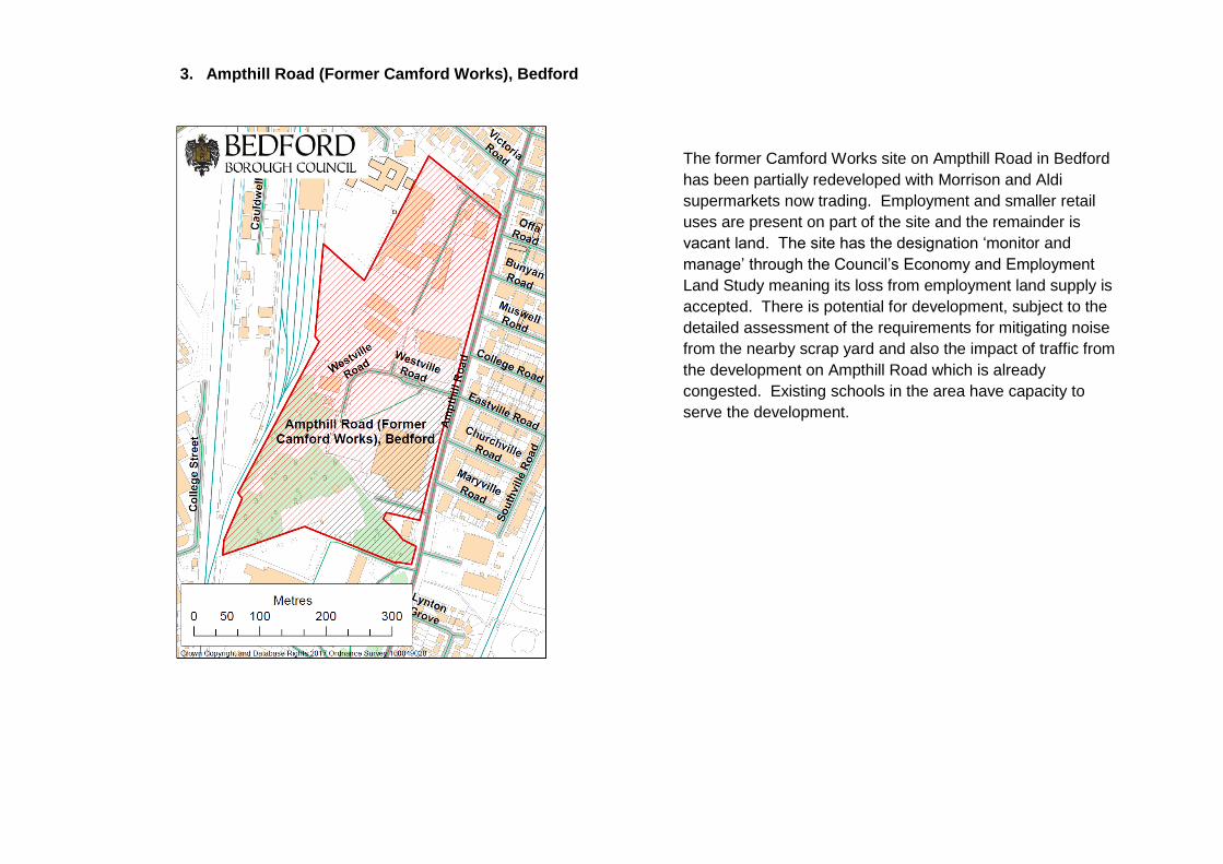
3. Ampthill Road (Former Camford Works), Bedford
The former Camford Works site on Ampthill Road in Bedford
has been partially redeveloped with Morrison and Aldi
supermarkets now trading. Employment and smaller retail
uses are present on part of the site and the remainder is
vacant land. The site has the designation ‘monitor and
manage’ through the Council’s Economy and Employment
Land Study meaning its loss from employment land supply is
accepted. There is potential for development, subject to the
detailed assessment of the requirements for mitigating noise
from the nearby scrap yard and also the impact of traffic from
the development on Ampthill Road which is already
congested. Existing schools in the area have capacity to
serve the development.