jeffares & green (pty) ltd sivest environmental division€¦ · · 2013-08-30compacted bulk...
TRANSCRIPT


Jeffares & Green (Pty) Ltd SiVEST Environmental Division
W:\2863 - Small Geotech Projects (CC)\01 - Grootvlei Desktop Study\05 - Documents & Reports\Geotechnical desktop study.doc
September 2011
BULK STORAGE FUEL OIL TANK AT GROOTVLEI POWER STATION
GEOTECHNICAL DESKTOP STUDY
CONTENTS
1. INTRODUCTION ....................................................................................................... 1
2. APPOINTMENT ......................................................................................................... 1
2.1. Information Available .......................................................................................... 1
3. SITE LOCATION ....................................................................................................... 2
4. PROJECT DESCRIPTION ........................................................................................ 4
5. SITE CONDITIONS ................................................................................................... 4
5.1. Geology................................................................................................................ 4
5.2. Topography and Drainage .................................................................................. 4
5.3. Climate ................................................................................................................. 4
5.4. Subsurface Conditions ....................................................................................... 5
5.4.1. Fill Material ...................................................................................................... 5
5.4.2. Colluvial Soils ................................................................................................. 5
5.4.3. Pedogenic Soils .............................................................................................. 5
5.4.4. Residual Soils ................................................................................................. 5
5.4.5. Weathered Sandstone Bedrock ..................................................................... 5
5.5. Groundwater ........................................................................................................ 5
5.6. Existing Underground Services ......................................................................... 6
6. PRELIMINARY GEOTECHNICAL AND IMPACT ASSESSMENT ............................ 6
7. CONCLUSIONS ........................................................................................................ 7
8. REFERENCES .......................................................................................................... 8
APPENDIX A: GEOLOGY MAP .................................................................................................. 9
APPENDIX B: Environmental Potential Atlas Data, 2001 – Mpumulanga Province ............. 10
APPENDIX C: IMPACT RATING SYSTEM ............................................................................... 11

Jeffares & Green (Pty) Ltd SiVEST Environmental Division
2863/01 Bulk Fuel Oil Tank at Grootvlei Power Station 1 Geotechnical Desktop Study September 2011
BULK STORAGE FUEL OIL TANK AT GROOTVLEI POWER STATION
GEOTECHNICAL DESKTOP STUDY
1. INTRODUCTION This report presents the results of a desktop geotechnical study undertaken for the proposed construction of a bulk fuel oil storage facility at Eksom’s Grootvlei Power Station. It is understood that either one or two bulk storage tanks with a total capacity of 500 m3 are required. Two alternative locations for the storage facility have been identified within the Grootvlei Power Station complex. Preliminary geotechnical information on each site is required as an input into an Environmental Impact Assessment (EIA) for the project, which is being undertaken by SiVEST Environmental Division. The objectives of the investigation are as follows:
• Assess the bedrock geology
• Assess the topographical conditions
• Identify problem soils (expansiveness, collapse potential and subsidence)
• Identify potential fatal flaws based on geotechnical considerations
• Provide a broad-scale assessment of the likely foundation conditions
• Evaluate potential construction constraints
• Assess the impact of the development on the geotechnical environment The information provided in this report is based on published geological maps, published geological and geotechnical information, the interpretation of aerial photography and the review of existing geotechnical reports. Site verification was not undertaken. This information is provided for initial planning proposes only. Further geotechnical investigations will be required for design purposes.
2. APPOINTMENT Jeffares & Green were appointed to undertake the study by SiVEST on 25 August 2011 based on a proposal submitted on 11 May 2011.
2.1. Information Available
The alternative locations were provided by SiVEST in the form of electronic shape files and aerial photograph images. The following sources of information were utilised during the study:
• 1:250 000 scale Geological Map 2628 East Rand published by the Council for Geoscience
• Environmental Potential Atlas Data, 2001 – Mpumulanga Province
• Engineering Geology of South Africa Volume 3 (Brink, 1983)
• Engineering Geology of South Africa Volume 4 (Brink, 1985)
• Various Jeffares & Green Geotechnical Reports on similar geological terrain
• Site photographs provided by SiVEST

Jeffares & Green (Pty) Ltd SiVEST Environmental Division
2863/01 Bulk Fuel Oil Tank at Grootvlei Power Station 2 Geotechnical Desktop Study September 2011
3. SITE LOCATION The Grootvlei Power Station is located in the western-most part of the Mpumulanga Province, as indicated in the Locality Plan, Figure 1. The two alternative locations of the storage facility, designated “Alternative 1” and “Alternative 2”, are indicated in the Site Plans, Figures 2a and 2b. Figure 1: Locality Plan

Jeffares & Green (Pty) Ltd SiVEST Environmental Division
2863/01 Bulk Fuel Oil Tank at Grootvlei Power Station 3 Geotechnical Desktop Study September 2011
Figure 2a: Site Plan – Large Scale
Figure 2b: Site Plan – Small Scale

Jeffares & Green (Pty) Ltd SiVEST Environmental Division
2863/01 Bulk Fuel Oil Tank at Grootvlei Power Station 4 Geotechnical Desktop Study September 2011
4. PROJECT DESCRIPTION As mentioned in Section 1, the project involves the construction a bulk fuel oil storage facility with a capacity of 500 m3. It is understood that either one 500 m3 capacity or two 250 m3 capacity above-ground storage tanks may be constructed. Above-ground storage tanks may be sensitive to foundation movements and settlement or heave movements (particularly differential movements) may be problematic. It is therefore important that sufficient geotechnical information is provided in order to produce a safe and economical foundation design. 5. SITE CONDITIONS The two alternative locations for the storage facility are located approximately 30 m apart within a highly-developed section of the Grootvlei Power Station complex. Given the broad-scale nature of the available data, much of the information provided in this report is valid to both sites. Significant factors which will affect the geotechnical conditions are discussed below.
5.1. Geology
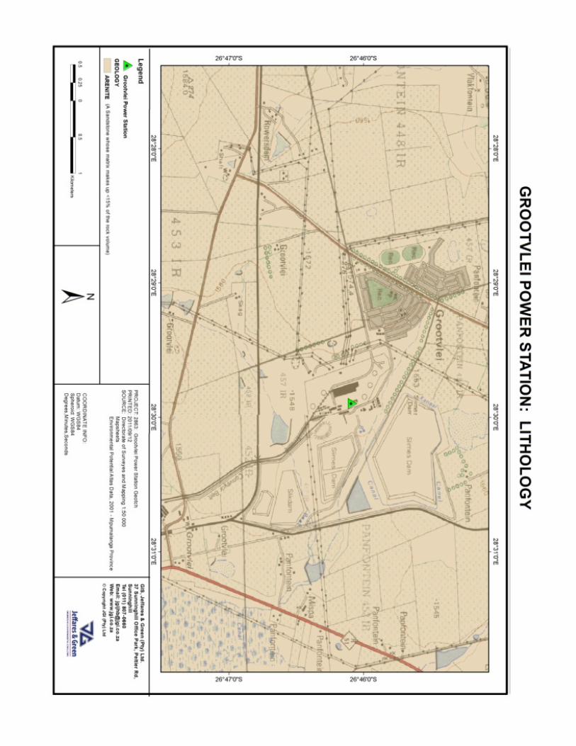
The site is underlain by sedimentary rock units of the Vryheid Formation of the Ecca Group, Karoo Supergroup. The Vryheid Formation is predominantly arenaceous (coarse grained) and consists of sandstones, grits, arkoses, mudrocks and coal seams. The abovementioned rock types are closely intercalated, resulting in a highly variable geotechnical conditions both vertically and horizontally. It is not unusual for a weak lens of mudrock to occur within a competent layer of sandstone, of for a band of rock to disappear horizontally over a short distance. The occurrence of weaker strata within or below competent rock strata may be problematic for the founding of heavy structures. The assumption that the founding conditions will improve with depth does not necessarily apply in the case of the Vryheid Formation. An extract of the 1:250 000 scale Geological Series map 2628 East Rand is attached in Appendix A. A Lithological Map based on the Environmental Potential Atlas Data, 2001, is also included in Appendix B.
5.2. Topography and Drainage
The topographical conditions at the sites are discussed in broad terms and are based on a visual assessment of un-contoured aerial photography, 1:50 000 scale topographic maps and site photographs. As a general rule, development on land with slope gradients of greater that approximately 12 degrees has significant cost implications and impacts on the topography as large scale cut-to-fill platforms and slope stability measures are typically required. The Power Station is located on gently undulating land near the crest of a broad hill and the natural topography is gentle to flat. Earthworks would have been undertaken to create level platforms during construction of the power station and some cut or fill activity may have been undertaken at the sites. There appear to be no natural drainage features in close proximity to the sites.
5.3. Climate
The climatic regime plays a fundamental role in rock weathering and the development of a soil profile. Weinert (1964), through his work on basic igneous rocks in Southern Africa, demonstrated that mechanical disintegration is the predominant mode of rock weathering in

Jeffares & Green (Pty) Ltd SiVEST Environmental Division
2863/01 Bulk Fuel Oil Tank at Grootvlei Power Station 5 Geotechnical Desktop Study September 2011
areas where his climatic “N-value” is greater than 5, while chemical decomposition predominates where the N-value is less than 5. The climatic N-value at the site is approximately 2.8, which implies that chemical decomposition is the dominant mode or rock weathering.
5.4. Subsurface Conditions
The following near-surface materials may be encountered at the sites.
5.4.1. Fill Material
Given the developed nature of the site fill material may be encountered immediately below existing ground level. This material may range from engineered fill to bulk fill and the engineering properties could vary from good (engineered fill) to poor (loosely compacted bulk fill).
5.4.2. Colluvial Soils
Colluvial soils are transported and deposited by non-fluvial processes. Based on information from the Environmental Potential Atlas (2001) the soil depth is expected to be between 450 to 750 mm. The soils are expected to be predominantly sandy in composition and are shown to have clay contents of between 15 and 35%.
5.4.3. Pedogenic Soils
The accumulation of iron oxides and hydrates is a commonly occurring pedogenic phenomenon related to a varying water table. This process takes place between the limits of a fluctuating water table and results in the formation of mottles and hard concretions, often with dark brown or black centres. With time the concretions may coalesce, resulting in an open honeycomb structure (commonly known as honeycomb ferricrete), or a continuous sheet of cemented material, commonly known as hardpan ferricrete. Pedogenic ferricrete is widespread in the area under investigation and the presence of a “plinthic catena”, which is characterised by mottling and iron accumulation, is noted in the Environmental Potential Atlas (2001) data. Care must be taken when founding structures on ferricrete as the hardened horizon may be underlain by much softer or looser material.
5.4.4. Residual Soils
Quartz, which is resistant to chemical weathering, typically comprises more than 50% of Karoo Supergroup sandstones and the resulting residual soils are predominately sandy in composition. However the feldspar component of the rock commonly weathers to clay minerals and the residual soils may be moderately plastic. Although residual soils derived from sandstones of the Vryheid Formation are typically adequate founding materials for lighter structures, loose or soft soil types may have low bearing capacities. Soils with a collapsible fabric have also been documented (Brink, 1983) in the region.
5.4.5. Weathered Sandstone Bedrock
Weathered sandstone rock may be encountered with depth. Although this material will provide a good founding medium for the proposed storage tanks, the depth to weathered rock may make founding the structure on this material unfeasible.
5.5. Groundwater
The site appears to be located on elevated ground, away from drainage features. However the presence of a shallow, perched water table may be encountered on site due to the

Jeffares & Green (Pty) Ltd SiVEST Environmental Division
2863/01 Bulk Fuel Oil Tank at Grootvlei Power Station 6 Geotechnical Desktop Study September 2011
presence of relatively impermeable ferricrete, bedrock, or clayey residual soils. The probability and severity of seepage will depend largely on the extent and effectiveness of the surface drainage system surrounding the sites. Goundwater conditions will fluctuate seasonally and the probability of groundwater seepage into excavations will increase during the wetter summer season.
5.6. Existing Underground Services
No information regarding the presence of underground services was available during the compilation of this report. Both sites are located within a highly-developed section of the Grootvlei Power Station complex and many underground services and other infrastructure are expected to be encountered on or surrounding the sites. It is imperative that the location, type and depth of all underground services and infrastructure in the vicinity of both sites are identified prior to the final site selection and the development of the storage tank facility. It is strongly recommended that construction of the storage tank/s does not take place over, or in close proximity to existing underground infrastructure. The presence of sensitive underground infrastructure may constitute a geotechnical “fatal flaw” at the site in question.
6. PRELIMINARY GEOTECHNICAL AND IMPACT ASSESSMENT From a geotechnical perspective no fatal flaws have been identified that would prevent development of a bulk fuel storage facility at either the Alternative 1 of Alternative 2 locations. Given the close proximity of the two alternative sites, similar geotechnical conditions are expected at each site. The existence of underground services, if present, will be a critical factor in determining the most suitable site from a geotechnical perspective. The design of the storage tank/s and their proposed foundation type had not been finalised at the time this report was compiled. Generic foundation recommendations are therefore provided. Potential constraints that the geotechnical conditions may impose on the construction of the fuel storage facility are provided in the Table 6.1. Possible engineering solutions to mitigate the risks imposed by these conditions are provided.
Table 6.1: Potential Geotechnical Constraints
Possible Geotechnical Constraints Possible Engineering Solutions
Description Probability Magnitude
Soils with low bearing capacity at founding level
Medium Medium Increase founding depth Soil raft construction
Shallow ground water conditions Medium Medium Dewater excavations during construction Install subsoil drainage system
Expansive soils Low Low Remove expansive soils beneath foundations Soil raft construction Raft / stiffened foundations
Highly variable soil conditions (presence of ferricrete layers)
Medium Low Various. Dependent on the properties of the ferricrete and underlying soils
Potential impacts of the project on the soils are provided in Table 6.2. A description of the weighting system and description of terms is attached in Appendix C.

Jeffares & Green (Pty) Ltd SiVEST Environmental Division
2863/01 Bulk Fuel Oil Tank at Grootvlei Power Station 7 Geotechnical Desktop Study September 2011
The development should not impact on the geology, as deep excavations into the bedrock will not be required.
Table 6.2: Impact of the project on the soils Impact Table
Environmental Parameter Soils
Issue/Impact/Environmental Effect/Nature Soil disturbance during foundation excavation and by heavy duty vehicles and construction equipment may destabilise the soil and lead to soil erosion
Extent Site only
Probability Unlikely given flat topography and the presence of existing drainage infrastructure
Reversibility Reversible with implementation of minor mitigation measures
Irreplaceable loss of resources Marginal loss of resources (soil)
Duration Construction period
Cumulative effect Negligible cumulative effects
Intensity / magnitude Low given the developed nature of the site
Significance rating Pre-mitigation impact
rating Post mitigation impact rating
Extent 4 4
Probability 2 1
Reversibility 4 4
Irreplaceable loss of resources 2 1
Duration 1 1
Cumulative effect 1 1
Intensity / magnitude 2 1
Significance rating 28 (Negative low impact) 12 (Negative low impact)
Mitigation measures i) Use of berms and drainage channels to direct water away from the construction area
ii) Limit the exposure time of open foundation excavations and cleared areas to the elements
iii) Rehabilitate disturbed areas as soon as possible after construction
iv) Ensure the correct disposal of spoil, either in a registered landfill site or as fill material in other construction activities
7. CONCLUSIONS The desktop geotechnical study did not identify any fatal flaws that, from a purely geotechnical perspective, would prevent the development of a bulk fuel oil storage facility at either the “Alternative 1” or “Alternative 2” locations. Certain geotechnical constraints may, however, be encountered at either site and these should be taken into account during development planning. Soils with low bearing capacity, shallow ground water conditions, expansive soils or the occurrence of ferricrete layers could be encountered. Examples of conventional engineering solutions to mitigate the risks imposed by these conditions are provided. The development of a bulk fuel oil storage facility at either the Alternative 1 of Alternative 2 locations is considered to have a low impact on the soils at the site. No information regarding the presence of underground services was available during the compilation of this report. Both sites are located within a highly-developed section of the Grootvlei Power Station complex and many underground services and other infrastructure

Jeffares & Green (Pty) Ltd SiVEST Environmental Division
2863/01 Bulk Fuel Oil Tank at Grootvlei Power Station 8 Geotechnical Desktop Study September 2011
are expected. The presence of sensitive underground infrastructure may constitute a geotechnical “fatal flaw” at the site in question. It is recommended that further detailed geotechnical investigations are undertaken at the preferred site to confirm the findings of this study. 8. REFERENCES 1. Brink, A.B.A. (1983). Engineering Geology of Southern Africa Volume 3 – The Karoo
Sequence. Building Publications Pretoria.
2. Brink, A.B.A. (1985). Engineering Geology of Southern Africa Volume 4 – Post-Gondwana Deposits. Building Publications Pretoria.
3. Johnson, M.R., Anhausser, C.R., Thomas, R.J. (1996) The Geology of South Africa. The
Geological Society of South Africa and the Council for Geoscience.
4. Weinert, H. H. (1964) Basic igneous rocks in road construction. Research Report 218, CSIR, Pretoria.

Jeffares & Green (Pty) Ltd SiVEST Environmental Division
2863/01 Bulk Fuel Oil Tank at Grootvlei Power Station 9 Geotechnical Desktop Study September 2011
APPENDIX A: GEOLOGY MAP


Jeffares & Green (Pty) Ltd SiVEST Environmental Division
2863/01 Bulk Fuel Oil Tank at Grootvlei Power Station 10 Geotechnical Desktop Study September 2011
APPENDIX B: Environmental Potential Atlas Data, 2001 – Mpumulanga Province


Jeffares & Green (Pty) Ltd SiVEST Environmental Division
2863/01 Bulk Fuel Oil Tank at Grootvlei Power Station 11 Geotechnical Desktop Study September 2011
APPENDIX C: IMPACT RATING SYSTEM

Table 1: Description of terms
NATURE
Include a brief description of the impact of environmental parameter being assessed in the context of the project. This criterion includes a brief written statement of the environmental aspect being impacted upon by a particular action or activity.
GEOGRAPHICAL EXTENT This is defined as the area over which the impact will be expressed. Typically, the severity and significance of an impact have different scales and as such bracketing ranges are often required. This is often useful during the detailed assessment of a project in terms of further defining the determined. 1 International and National Will affect the entire country 2 Province/region Will affect the entire province or region 3 Local/district Will affect the local area or district 4 Site The impact will only affect the site
PROBABILITY
This describes the chance of occurrence of an impact
1 Unlikely
The chance of the impact occurring is extremely low (Less than a 25% chance of occurrence).
2 Possible
The impact may occur (Between a 25% to 50% chance of occurrence).
3 Probable
The impact will likely occur (Between a 50% to 75% chance of occurrence).
4 Definite
Impact will certainly occur (Greater than a 75% chance of occurrence).
REVERSIBILITY
This describes the degree to which an impact on an environmental parameter can be successfully reversed upon completion of the proposed activity.
1 Irreversible The impact is irreversible and no mitigation measures exist.
2 Barely reversible The impact is unlikely to be reversed even with intense mitigation measures.
3 Partly reversible The impact is partly reversible but more intense mitigation measures are required.
4 Completely reversible The impact is reversible with implementation of minor mitigation measures

IRREPLACEABLE LOSS OF RESOURCES
This describes the degree to which resources will be irreplaceably lost as a result of a proposed activity. 1 No loss of resource. The impact will not result in the loss of any resources. 2 Marginal loss of resource The impact will result in marginal loss of resources. 3 Significant loss of resources The impact will result in significant loss of resources. 4 Complete loss of resources The impact is result in a complete loss of all resources.
DURATION
This describes the duration of the impacts on the environmental parameter. Duration indicates the lifetime of the impact as a result of the proposed activity
1 Short term
The impact and its effects will either disappear with mitigation or will be mitigated through natural process in a span shorter than the construction phase (0 – 1 years), or the impact and its effects will last for the period of a relatively short construction period and a limited recovery time after construction, thereafter it will be entirely negated (0 – 2 years).
2 Medium term
The impact and its effects will continue or last for some time after the construction phase but will be mitigated by direct human action or by natural processes thereafter (2 – 10 years).
3 Long term
The impact and its effects will continue or last for the entire operational life of the development, but will be mitigated by direct human action or by natural processes thereafter (10 – 50 years).
4 Permanent
The only class of impact that will be non-transitory. Mitigation either by man or natural process will not occur in such a way or such a time span that the impact can be considered transient (Indefinite).
CUMULATIVE EFFECT
This describes the cumulative effect of the impacts on the environmental parameter. A cumulative effect/impact is an effect which in itself may not be significant but may become significant if added to other existing or potential impacts emanating from other similar or diverse activities as a result of the project activity in question.
1 Negligible Cumulative Impact The impact would result in negligible to no cumulative effects
2 Low Cumulative Impact The impact would result in insignificant cumulative effects 3 Medium Cumulative impact The impact would result in minor cumulative effects

4 High Cumulative Impact The impact would result in significant cumulative effects
INTENSITY / MAGNITUDE
Describes the severity of an impact
1 Low Impact affects the quality, use and integrity of the system/component in a way that is barely perceptible.
2 Medium
Impact alters the quality, use and integrity of the system/component but system/ component still continues to function in a moderately modified way and maintains general integrity (some impact on integrity).
3 High
Impact affects the continued viability of the system/component and the quality, use, integrity and functionality of the system or component is severely impaired and may temporarily cease. High costs of rehabilitation and remediation.
4 Very high
Impact affects the continued viability of the system/component and the quality, use, integrity and functionality of the system or component permanently ceases and is irreversibly impaired (system collapse). Rehabilitation and remediation often impossible. If possible rehabilitation and remediation often unfeasible due to extremely high costs of rehabilitation and remediation.
SIGNIFICANCE Significance is determined through a synthesis of impact characteristics. Significance is an indication of the importance of the impact in terms of both physical extent and time scale, and therefore indicates the level of mitigation required. This describes the significance of the impact on the environmental parameter. The calculation of the significance of an impact uses the following formula: (Extent + probability + reversibility + irreplaceability + duration + cumulative effect) x magnitude/intensity. The summation of the different criteria will produce a non weighted value. By multiplying this value with the magnitude/intensity, the resultant value acquires a weighted characteristic which can be measured and assigned a significance rating. Points Impact Significance
Rating Description

6 to 28 Negative Low impact The anticipated impact will have negligible negative effects and will require little to no mitigation.
6 to 28 Positive Low impact The anticipated impact will have minor positive effects. 29 to 50 Negative Medium
impact The anticipated impact will have moderate negative effects and will require moderate mitigation measures.
29 to 50 Positive Medium impact
The anticipated impact will have moderate positive effects.
51 to 73 Negative High impact The anticipated impact will have significant effects and will require significant mitigation measures to achieve an acceptable level of impact.
51 to 73 Positive High impact The anticipated impact will have significant positive effects.
74 to 96 Negative Very high impact
The anticipated impact will have highly significant effects and are unlikely to be able to be mitigated adequately. These impacts could be considered "fatal flaws".
74 to 96 Positive Very high impact
The anticipated impact will have highly significant positive effects.
The table below is to be represented in the Impact Assessment section of the report. Table 2: Rating of impacts
IMPACT TABLE FORMAT Environmental Parameter A brief description of the environmental aspect likely to
be affected by the proposed activity e.g. Surface water Issue/Impact/Environmental Effect/Nature
A brief description of the nature of the impact that is likely to affect the environmental aspect as a result of the proposed activity e.g. alteration of aquatic biota The environmental impact that is likely to positively or negatively affect the environment as a result of the proposed activity e.g. oil spill in surface water
Extent A brief description indicating the chances of the impact occurring
Probability A brief description of the ability of the environmental components recovery after a disturbance as a result of the proposed activity
Reversibility A brief description of the environmental aspect likely to be affected by the proposed activity e.g. Surface water
Irreplaceable loss of resources A brief description of the degree in which irreplaceable resources are likely to be lost
Duration A brief description of the amount of time the proposed activity is likely to take to its completion

IMPACT TABLE FORMAT Cumulative effect A brief description of whether the impact will be
exacerbated as a result of the proposed activity Intensity/magnitude A brief description of whether the impact has the ability to
alter the functionality or quality of a system permanently or temporarily
Significance Rating A brief description of the importance of an impact which in turn dictates the level of mitigation required
Pre-mitigation impact rating Post mitigation impact rating
Extent 4 1 Probability 4 1 Reversibility 4 1 Irreplaceable loss 4 1 Duration 4 1 Cumulative effect 4 1 Intensity/magnitude 4 1 Significance rating -96 (high negative) -6 (low negative)
Mitigation measures
Outline/explain the mitigation measures to be undertaken to ameliorate the impacts that are likely to arise from the proposed activity. Describe how the mitigation measures have reduced/enhanced the impact with relevance to the impact criteria used in analyzing the significance. These measures will be detailed in the EMPR.