jlr-21 gps compass 3d dynamic sensor - jrc · jlr-21 gps compass 3d dynamic sensortm ... gyro...
TRANSCRIPT
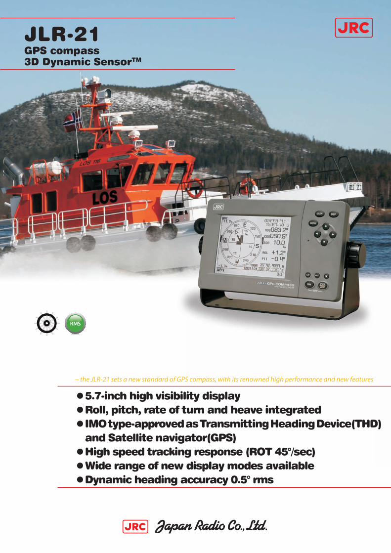
JLR-21GPS compass3D Dynamic SensorTM
●5.7-inch high visibility display●Roll, pitch, rate of turn and heave integrated●IMO type-approved as Transmitting Heading Device(THD) and Satellite navigator(GPS)●High speed tracking response (ROT 45°/sec)●Wide range of new display modes available●Dynamic heading accuracy 0.5° rms
– the JLR-21 sets a new standard of GPS compass, with its renowned high performance and new features
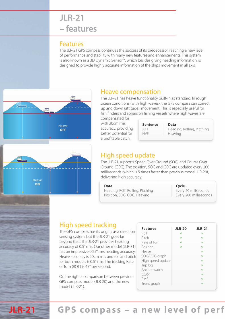
FeaturesRollPitchRate of TurnPositionHeaveSOG/COG graphHigh speed updateTrip logAnchor watchCCRPRMSTrend graph
JLR-20vvvv
JLR-21vvvvvvvvvvvv
JLR-21– features
The JLR-21 GPS compass continues the success of its predecessor, reaching a new level of performance and stability with many new features and enhancements. This system is also known as a 3D Dynamic Sensor™, which besides giving heading information, is designed to provide highly accurate information of the ships movement in all axis.
Features
The GPS compass has its origins as a direction sensing system, but the JLR-21 goes far beyond that. The JLR-21 provides heading accuracy of 0.5° rms. Our other model (JLR-31) has an impressive 0.25° rms heading accuracy. Heave accuracy is 20cm rms and roll and pitch for both models is 0.5° rms. The tracking Rate of Turn (ROT) is 45° per second.
On the right a comparison between previous GPS compass model (JLR-20) and the new model (JLR-21).
High speed tracking
G P S co m p a s s – a n e w l e ve l o f p e r fJLR-21
HeaveOFF
HeaveON
DataHeading, Rolling, PitchingHeaving
SentenceATTHVE
DataHeading, ROT, Rolling, Pitching Position, SOG, COG, Heaving
CycleEvery 20 milisecondsEvery 200 milliseconds
The JLR-21 has heave functionality built-in as standard. In rough ocean conditions (with high waves), the GPS compass can correct up and down (attitude), movement. This is especially useful for fi sh fi nders and sonars on fi shing vessels where high waves are
The JLR-21 supports Speed Over Ground (SOG) and Course Over Ground (COG). The position, SOG and COG are updated every 200 milliseconds (which is 5 times faster than previous model JLR-20), delivering high accuracy.
compensated for with 20cm rms accuracy, providing better potential for a profi table catch.
Heave compensation
High speed update
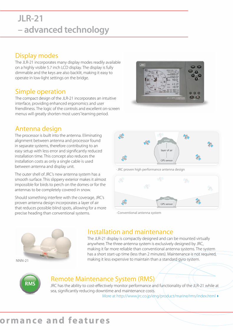
· JRC proven high performance antenna design
· Conventional antenna system
NNN-21
o r m a n ce a n d fe at u re s
JLR-21– advanced technology
The JLR-21 incorporates many display modes readily available on a highly visible 5.7 inch LCD display. The display is fully dimmable and the keys are also backlit, making it easy to operate in low-light settings on the bridge.
The compact design of the JLR-21 incorporates an intuitive interface, providing enhanced ergonomics and user friendliness. The logic of the controls and excellent on-screen menus will greatly shorten most users’ learning period.
The processor is built into the antenna. Eliminating alignment between antenna and processor found in separate systems, therefore contributing to an easy setup with less error and signifi cantly reduced installation time. This concept also reduces the installation costs as only a single cable is used between antenna and display unit.
The outer shell of JRC’s new antenna system has a smooth surface. This slippery exterior makes it almost impossible for birds to perch on the domes or for the antennas to be completely covered in snow.
Should something interfere with the coverage, JRC’s proven antenna design incorporates a layer of air that reduces possible blind spots, allowing for a more precise heading than conventional systems.
Display modes
Simple operation
Antenna design
The JLR-21 display is compactly designed and can be mounted virtually anywhere. The three-antenna system is exclusively designed by JRC, making it far more reliable than conventional antenna systems. The system has a short start-up time (less than 2 minutes). Maintenance is not required, making it less expensive to maintain than a standard gyro system.
Installation and maintenance
JRC has the ability to cost-eff ectively monitor performance and functionality of the JLR-21 while at sea, signifi cantly reducing downtime and maintenance costs.
More at http://www.jrc.co.jp/eng/product/marine/rms/index.html ▸
Remote Maintenance System (RMS)
GPS compassNo
typically 30 secondsHigh speed
GoodNoNo
Gyro compassYes
about 4 hoursMiddle speed
GoodNoYes
for latitude
Magnetic compassYesno
Low speedBadYesYes
for variation, deviation
Periodic maintenanceSettling timeTracking responseAccuracyMagnetic influenceCorrection
Standard in the box∙ Display∙ Antenna∙ Cables∙ Installation parts∙ Spare parts∙ Manual
Cables∙ Power cable display 2 m∙ Serial data cable 3 m∙ Display to antenna2 10 m
Options∙ Serial data cable ∙ Sensor extension cable ∙ Flush mount kit ∙ AC power rectifier ∙ DGPS receiver
CFQ-5374 (3 m)CFQ-7249 (20 m)MPBC43664NBG-320 JLR-4341
Consistent Common Reference Point The cable length may vary depending on sales region.1. 2.
JLR-21– unique functions
Measuring tool Trend graphCCRP and Anchor watchThe GPS compass allows calculation of distance and bearing between any two points, supporting Rhumb Lines (RL) for the short legs and Great Circle (GC) for long distance legs. Also, a trip log function comes standard for distance and heading.
The new trend graph display mode shows a history of roll, pitch and heave and SOG as an easy-to-read graphical view. Selections can be made to show maximum or average results.
The JLR-21 has CCRP1 function incorporated, allowing the transfer of CCRP sentences to other onboard equipment and anchor watch alerts the watch offi cer of possible anchor dragging situations.
Interfaces
JLR-21 and IMO recommendations
The new GPS compass integrates 5 independent working NMEA output ports, which allows for connection to a wide range of onboard navigation equipment, such as radar, plotter, autopilot, sonar or other navigation devices.
Traditionally, the means used to measure the heading of a ship has been a mechanical gyrocompass and/or a traditional magnetic compass. With the adoption of the new installation requirements in SOLAS-V, all passenger ships and all ships from 300 to 500 GT travelling international routes can now install a new technology directional sensor, the Transmitting Heading Device (THD).JRC’s new JLR-21, IMO type-approved as both Transmitting Heading Device (THD) and as Satellite Navigator (GPS), suits for the vessels as SOLAS-V required primary heading sensor or primary GPS.
IMO performance standard Gross TonnageTransmitting Heading Device(THD) From 300GT to less than 500GT
Satellite Navigator(GPS) 20GT or more

AntennaNNN-21 MASS 5,9 kg
Display
built in processorunit
621 mm
450 mm
285 mm561 mm
The maximum cable length between antenna and display is 50 m. Note that extensions should be of a shielded multicore cable to prevent noise or attenuation.
JLR-21– size and mass
NWZ-4701 MASS 2,3 kg
Cutout dimensionsfor flush mounting Height 116 mm Width 220 mm Depth 64 mm
System diagram
NNN-21 (JLR-21) NNN-31 (JLR-31) JLR-4341 (DGPS)
Sensor cable (10 m)
Power cable (2 m)
Serial data cable (3 m)
Power 12V DC (for DGPS receiver)
12V to 24V DC
RadarECDIS/GPS plotterCurrent meterAISRepeateretc.
StandardOption
NBG-320
AC power100/220V AC
268 mm
5.7”
230 mm
142 mm
85 mm
70 mm
162 mm

For further information, contact:
Since 1915
Main Office:
Overseas Branches : Seattle, Amsterdam, Athens, Manila Liaison Offices : Taipei, Jakarta, Singapore, Hanoi,
Hamburg, New York
28EM ISO9001,ISO14001 Certified
●Specifications may be subject to change without notice.
Printed in Japan2011.7 CAT.No.Y3-146(No.514-2-3)D2012.10
Fujisawa bldg. 30-16, Ogikubo 4-chomeSuginami-ku, Tokyo 167-8540, JapanTelephone: +81-3-6832-1816Facsimile: +81-3-6832-1845
Name GPS Compass/GPS NavigatorModel JLR-21IMO approved (THD) vIMO approved (GPS) vSensor
Model NNN-21Receiver Type Multi channel all-in-view (12ch + 1ch SBAS) Frequency 1575.42MHz ± 1MHz(C/A code)Direction accuracy 0.5º rmsRolling accuracy 0.5° rmsPitching accuracy 0.5° rmsHeaving accuracy 20cm rmsDisplay resolution 0.1ºResolution output 0.1º or 0.01º (selectable)Tracking Rate of Turn 45º / secTracking acceleration 1GStart-up time less than 2 minutes (warm start fi x, typically 30 seconds)DGPS input RTCM SC-104 Ver.2.0 Type 1, 2, 9, 16SBAS receiver Built-in(MSAS/WAAS/EGNOS)RAIM function Built-in
Position accuracyGPS : 12m 2drms (C/A code, HDOP≦4, SA OFF)
SBAS : 6m 2drms when SBAS corrected DGPS : 4m 2drms when DGPS corrected (when connected to beacon receiver)
Protection IPX6
Ambient conditions -25 to +55°C (operational)-25 to +70°C (storage)
DisplayModel NWZ-4701Display 5.7-inch LCD, 320 by 240 pixels
Display modes Compass rose, bow heading, navigation, rate of turn (ROT), water/ground speed, trend graph, calculation, GPS status
Direction & nav. data output 1)
IEC61162/NSK(shared) 5 ports (AD-10 output availuable: 2 of 5 ports) IEC61162 output: HDT, THS, ROT, ZDA, GGA, VTG, RMC, GBS, DTM, GSA,
GSV, GNS, MSS, GST, GLL, ALR, ATT, HVECurrent data input 1 port(CUR, VBW)
Alarm contact signal 2 ports (alarm output)1 port (ACK input)
LOG pulse 1 port (off , 200p/NM, 400p/NM)Protection IPX4
Ambient conditions-15 to +55°C (operational)
-25 to +70°C (strage)Power 12 to 24V DC (-10% to +30%)Power consumption 12W (including sensor), 6W (excluding sensor)Vibration/EMC IEC60945 ed4OptionsRectifi er NBG-320Data cable (for serial data) CFQ-5374 (3m), CFQ-5374-15 (15m)Data cable (for contact signal) CFQ-5404 (3m), CFQ-5404-15 (15m)Extention cable (sensor-display) CFQ-7249 (20m), CFQ-7249-10 (10m)Junction box NQE-7720Data cable (for sub display) CFQ-7251 (1.5m Y-cable)Data cable (for JRC Radar) 2) CFQ-5469 (10m)Mount base (for NNN-21) MPBX44117
1) Selectable sentences depend on versions (NMEA 1.5, 2.1, 2.3 Some combinations of output sentence, bit rate, and output intervals may not be possible ATT and HVE sentence can be set from output cycles of 25ms, 100ms, 200ms, 1s, 2s only2) Accepted for JMA-3300/5100/5200/5200MK2/5300/5300MK2 series
JLR-21– specifi cations