kale_the-sinuous-bedrock-channel-of-the-tapi-river,-central-india-its-form-and-processes_2005.pdf
TRANSCRIPT

7/27/2019 Kale_The-sinuous-bedrock-channel-of-the-Tapi-River,-Central-India-Its-form-and-processes_2005.pdf
http://slidepdf.com/reader/full/kalethe-sinuous-bedrock-channel-of-the-tapi-river-central-india-its-form-and-processes2005pdf 1/15
The sinuous bedrock channel of the Tapi River, Central India:
Its form and processes
Vishwas S. KaleT
Department of Geography, University of Pune, Pune 411 007, India
Received 15 September 2003; received in revised form 3 March 2004; accepted 14 February 2005Available online 19 April 2005
Abstract
The Tapi Gorge lies in the monsoon-dominated region of the Indian subcontinent. Because of the seasonality of rainfall and
flows all the fluvial activity in the bedrock gorge is confined to the monsoon season, in general, and during a few high-
magnitude monsoon floods in particular. Field investigations along a 30-km reach of the sinuous bedrock gorge indicate that the
river displays all the morphologic properties of a meandering alluvial channel albeit with a much higher level of energy
expenditure. Considering the perimeter lithology and channel morphology two types of reaches are evident in the field: a
predominantly rocky and relatively straight reach close to the gorge-head, and a longer, sinuous reach of gravel deposition
downstream. Hydraulic modeling of a rainfall-induced dam-failure flood indicates that large-magnitude events that exceed thethreshold of bedrock resistance for a sustained length of time are capable of erosion. It appears that the overall channel and
gorge morphology is adjusted to two types of thresholds. A threshold of boulder-transport, which is associated with large floods
that are competent to entrain boulders but are incapable of bedrock erosion; and another higher threshold that is exceeded by
truly high-energy processes that generate large total energy and exceed the threshold of bedrock resistance. The later threshold
is exceeded only episodically, with fairly long periods of little or no bedrock erosion in between.
Interestingly, meso-scale erosional features such as inner channels and well-developed potholes are nearly absent or
inconspicuous within the gorge section. Whilst this could be partly attributed to the bedrock resistance, it appears that under the
present hydro-geomorphic conditions the dominant fluvial activity is not directed towards the channel bed, but towards the
banks. This is evident from the concentration of erosion on the outer banks and deposition of coarse gravel on the inner banks,
and armoring of the channel bed. The main conclusion of the study is that the bedrock channel is increasing the flow resistance
and energy losses by developing and enhancing the meandering pattern.
D 2005 Elsevier B.V. All rights reserved.
Keywords: Monsoon floods; Bedrock gorge; Meandering pattern; Gravel deposits; Tapi River; India
1. Introduction
In the monsoonal and seasonal tropics the geo-
morphic work is strictly confined to the wet season
0169-555X/$ - see front matter D 2005 Elsevier B.V. All rights reserved.
doi:10.1016/j.geomorph.2005.02.016
T Tel.: +91 20 2560 1248.
E-mail addresses: [email protected],
vs _ [email protected].
Geomorphology 70 (2005) 296–310
www.elsevier.com/locate/geomorph
7/27/2019 Kale_The-sinuous-bedrock-channel-of-the-Tapi-River,-Central-India-Its-form-and-processes_2005.pdf
http://slidepdf.com/reader/full/kalethe-sinuous-bedrock-channel-of-the-tapi-river-central-india-its-form-and-processes2005pdf 2/15
and in the dry season the rivers are predominantly
inactive or dormant (Kale, 2002). Even during the wet
season, the response of the stream channels to high
monsoon flows is essentially determined by the litho-logy of the channel perimeter and channel geometry.
Whilst in alluvial channels the more commonly
occurring moderate flows are effective (Wolman and
Miller, 1960; Gupta, 1995), in bedrock channels
noteworthy fluvial activity is associated only with
high-energy processes t hat occur during infrequent,
large-magnitude floods (Baker, 1977, 1988; Kale and
Hire, 2004). Because of high boundary resistance and
coarse bedload, moderate- and low-magnitude flows
are incapable of transporting the coarse bedload and/or
changing the morphologies of the non-alluvial river channels (Baker and Costa, 1987). Consequently, the
geomorphically effective flows in bedrock-dominated
channels have larger recurrence intervals (Tinkler,
1971; Kale and Hire, 2004).
Given the relatively large recurrence interval of
geomorphically effective flows in seasonally wet
areas, channels incised into bedrock develop mor-
phologies that yield the optimum energy expenditures
of flow (Baker and Kale, 1998). Similar to the alluvial
channels, an adjustment occurs in the channel
morphology, sinuosity, and gradient to energy expen-
diture at a higher level associated with large-magni-
tude f loods. Whereas amazingly high energy
expenditure is achieved along relatively straight and
constricted reaches, a sinuous or meandering channel
pattern reduces energy expenditure and evens out the
loss of power along the flow path (Baker and Kale,
1998).
This paper will consider the morphological and
hydraulic characteristics of the sinuous bedrock
channel of the Tapi River in central India. The main
objectives are to record and explain the longitudinal
variations in the morphologic and sediment charactersof the sinuous bedrock gorge, and to understand the
role of lithology and the variations in the hydraulic
conditions along the bedrock channel.
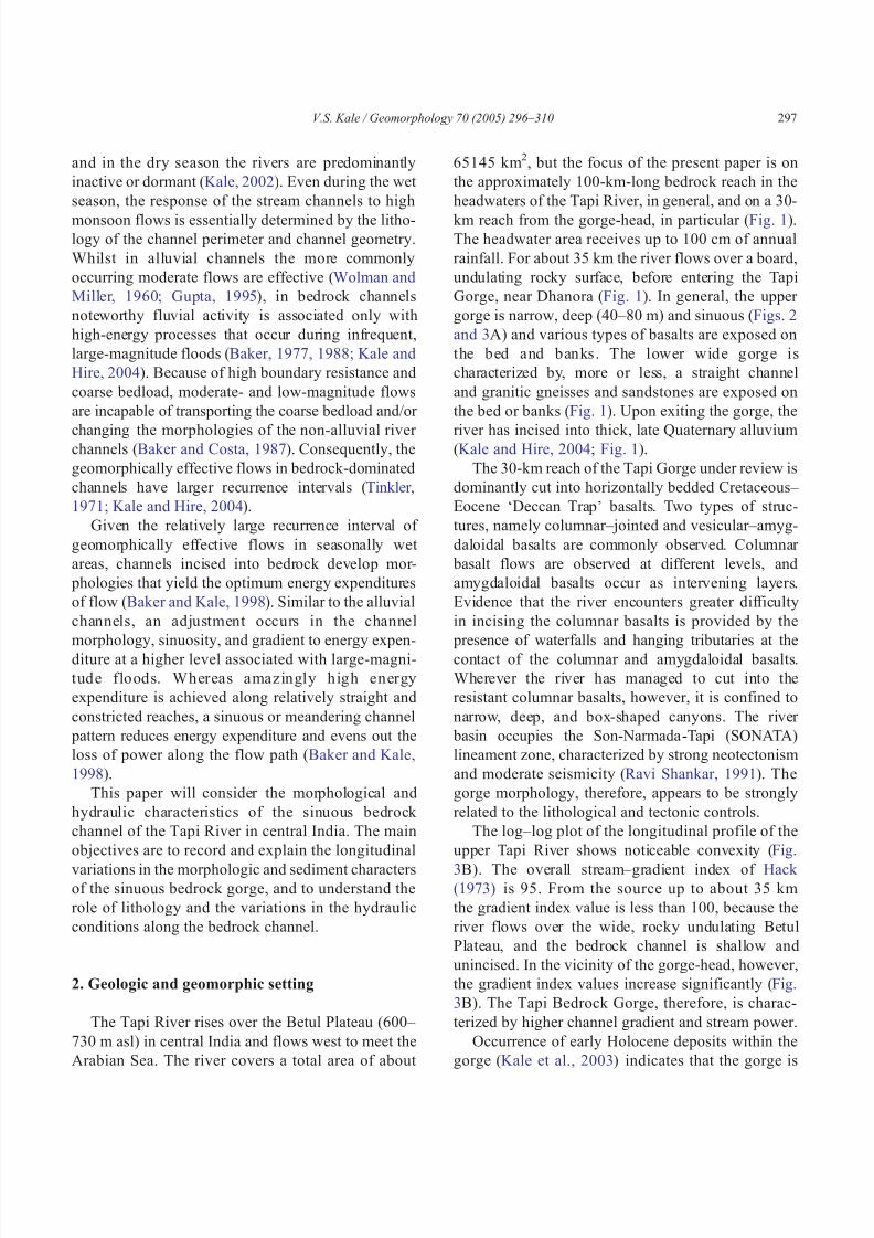
2. Geologic and geomorphic setting
The Tapi River rises over the Betul Plateau (600–
730 m asl) in central India and flows west to meet the
Arabian Sea. The river covers a total area of about
65145 km2, but the focus of the present paper is on
the approximately 100-km-long bedrock reach in the
headwaters of the Tapi River, in general, and on a 30-
km reach from the gorge-head, in particular (Fig. 1).The headwater area receives up to 100 cm of annual
rainfall. For about 35 km the river flows over a board,
undulating rocky surface, before entering the Tapi
Gorge, near Dhanora (Fig. 1). In general, the upper
gorge is narrow, deep (40–80 m) and sinuous (Figs. 2
and 3A) and various types of basalts are exposed on
the bed and banks. The lower wide gorge is
characterized by, more or less, a straight channel
and granitic gneisses and sandstones are exposed on
the bed or banks (Fig. 1). Upon exiting the gorge, the
r iver has incised into t hick, late Quaternary alluvium(Kale and Hire, 2004; Fig. 1).
The 30-km reach of the Tapi Gorge under review is
dominantly cut into horizontally bedded Cretaceous–
Eocene dDeccan TrapT basalts. Two types of struc-
tures, namely columnar–jointed and vesicular–amyg-
daloidal basalts are commonly observed. Columnar
basalt flows are observed at different levels, and
amygdaloidal basalts occur as intervening layers.
Evidence that the river encounters greater difficulty
in incising the columnar basalts is provided by the
presence of waterfalls and hanging tributaries at the
contact of the columnar and amygdaloidal basalts.
Wherever the river has managed to cut into the
resistant columnar basalts, however, it is confined to
narrow, deep, and box-shaped canyons. The river
basin occupies the Son-Narmada-Tapi (SONATA)
lineament zone, characterized by strong neotectonism
and moderate seismicity (Ravi Shankar, 1991). The
gorge morphology, therefore, appears to be strongly
related to the lithological and tectonic controls.
The log–log plot of the longitudinal profile of the
upper Tapi River shows noticeable convexity (Fig.
3B). The overall stream–gradient index of Hack (1973) is 95. From the source up to about 35 km
the gradient index value is less than 100, because the
river flows over the wide, rocky undulating Betul
Plateau, and the bedrock channel is shallow and
unincised. In the vicinity of the gorge-head, however,
the gradient index values increase significantly (Fig.
3B). The Tapi Bedrock Gorge, therefore, is charac-
terized by higher channel gradient and stream power.
Occurrence of early Holocene deposits within the
gorge (Kale et al., 2003) indicates that the gorge is
V.S. Kale / Geomorphology 70 (2005) 296–310 297
7/27/2019 Kale_The-sinuous-bedrock-channel-of-the-Tapi-River,-Central-India-Its-form-and-processes_2005.pdf
http://slidepdf.com/reader/full/kalethe-sinuous-bedrock-channel-of-the-tapi-river-central-india-its-form-and-processes2005pdf 3/15
F i g .
1 .
G e o m o r p h i c m a p o f t h e u p p e r T a p i G o r g e .
V.S. Kale / Geomorphology 70 (2005) 296–310298

7/27/2019 Kale_The-sinuous-bedrock-channel-of-the-Tapi-River,-Central-India-Its-form-and-processes_2005.pdf
http://slidepdf.com/reader/full/kalethe-sinuous-bedrock-channel-of-the-tapi-river-central-india-its-form-and-processes2005pdf 4/15
pre-Holocene in age. The preservation of the deposits
also suggests that probably the overall morphology of
the bedrock gorge has not changed significantly since
early Holocene times.
3. River hydrology
The Tapi River is entirely fed by monsoon rains.
Measurable flows occur only during the monsoon
season (June to October) and for a short time after the
end of the monsoon season. During the long dry
summer season, the channel is virtually dry. Only large
pools contain water. Consequently, all of the fluvial
activity takes place during the 4–5 months of the
monsoon season. During the remaining part of the year
the channel is totally inactive. Because the channel
boundaries are resistant and the channel bed material is
coarse, most of the common monsoon flows are incom-
petent to cause erosion or to move the coarse gravel.
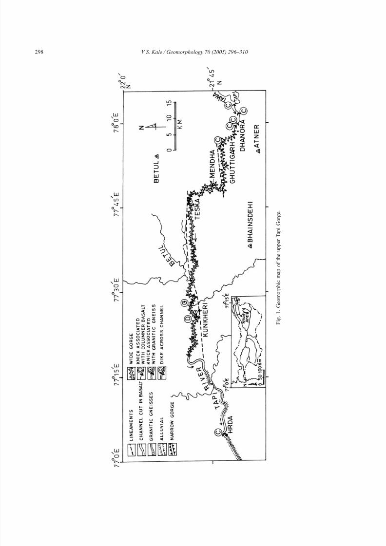
Long continuous gauge data were not available for
any site within the study area. To get some idea about
the intra-seasonal variations in the monsoon dis-charges, daily discharge data for a sample year
(1988–1989) for the Dedtalai gauging station, located
ca. 190 km from the source, are presented in Fig. 4.
This figure shows that the monsoon flow (June to
October) is occasionally interrupted by large-magni-
tude events. These events occur in response to large
amounts of monsoon rainfall in the source region
(Kale et al., 1994). During such events, most of the
geomorphic activity takes place within the gorge. The
discharge pattern suggests that the bedrock gorge is
0 2 km
Goinda
Mendha
Fig. 2. Indian Remote Sensing satellite image (FCC) of the study area (acquired in November, 1996). Data Source: National Remote Sensing
Agency (NRSA), Hyderabad, India.
Fig. 3. (A) Cross-section across the Betual Plateau and the Tapi
Gorge. (B) Longitudinal profile of the upper Tapi River showing
values of Hack’s (1973) stream–gradient index.
V.S. Kale / Geomorphology 70 (2005) 296–310 299
7/27/2019 Kale_The-sinuous-bedrock-channel-of-the-Tapi-River,-Central-India-Its-form-and-processes_2005.pdf
http://slidepdf.com/reader/full/kalethe-sinuous-bedrock-channel-of-the-tapi-river-central-india-its-form-and-processes2005pdf 5/15
subjected to extreme variations in discharge and
energy conditions even during the wet season (Kale
and Hire, 2004).
4. Methodology
The 30-km reach described in this paper forms the
upper part of the Tapi Gorge. The present study is
entirely based on field investigations in the upper
narrow section of the gorge. Observations regarding
channel morphology, erosional and depositional fea-
tures, bed and bank material, and lithology were made
in the field during the non-monsoon season and the
information was recorded on a map. The width and
depth of channel flow were measured at 24 cross-
sections along the 30-km reach of the gorge (Table 1).
The flow depths were estimated on the basis of high
water marks and information provided by the local people.
In July 1991, a rainfall-induced failure of a dam,
located upstream of the Tapi Gorge-head, generated a
flood far larger than possible from extreme amounts of
monsoon rainfall (Kale et al., 1994). This event was
unprecedented in the recent geomorphic history of the
Tapi River. Because the event provided an excellent
opportunity to understand the impact of a rare, high-
magnitude event on bedrock channels, post-flood
studies were undertaken downstream of the dam, and
high water marks and information regarding changes
in the channel morphology were recorded at 33 loca-
tions downstream of the dam (Kale and Gadgil, 1997).
Because the gorge section is ungauged, multiple
cross-section surveys were undertaken at two sites
with the help of an Electronic Distance Measurer
(EDM), and the flood hydraulics were reconstructed
by employing the step-backwater flow model—HEC2
(Hydrologic Engineering Centre, 1982) and the high
water marks (Kale and Gadgil, 1997). The hydraulic
step-backwater routine was used to estimate the
discharge of the common monsoon high flows, one
of the largest monsoon floods that occurred in 1994
and the July 1991 dam-failure flood. The common
high monsoon flow was assumed to be close to ca.
2000 m3 sÀ1 on the basis of information provided by
the local people.
5. Bedrock channel morphology
Fig. 5 shows the geomorphic map of the 30-km
reach under review. The data regarding channel width
and depth, channel characteristics and the average
intermediate diameter of boulders collected at 24
cross-sections are presented in Table 1.
Approximately 13 km downstream of the gorge-
head (knick point) the river flows through a narrow
bedrock gorge with steep to near-vertical walls. The
Fig. 4. Variation in the daily discharge for a sample year (1988–1989) for the Dedtalai gauging station, located ca. 190 km from the source.
Catchment area=3860 km2. Data source: Water Year Book, Central Water Commission, New Delhi.
V.S. Kale / Geomorphology 70 (2005) 296–310300

7/27/2019 Kale_The-sinuous-bedrock-channel-of-the-Tapi-River,-Central-India-Its-form-and-processes_2005.pdf
http://slidepdf.com/reader/full/kalethe-sinuous-bedrock-channel-of-the-tapi-river-central-india-its-form-and-processes2005pdf 6/15
channel width generally varies between 70 and 120 m
(Table 1). Downstream the channel widens and the
width varies between 130 and 275 m (Table 1). Fig. 5
also reveals that steep or precipitous gorge walls are
usually present along the outer banks of the sinuous
channel of the Tapi River.According to the lithology of channel perimeter and
channel morphology two main types of channel cate-
gories—(i) predominantly rocky reach, and (ii) reach of
gravel deposition, could be identified in the field. The
representative cross-sections are shown in Fig. 6.
5.1. Predominantly rocky reach (Reach-1)
This reach occurs close to the gorge-head (cross
sections 1 to 4; Fig. 5) and is characterized by a
relatively steep gradient, narrow channel, and low
sinuosity (Fig. 7). Erosional forms and features
dominate this reach. The gradient is high, about
0.0072. Two major breaks in longitudinal profile,
represented by waterfalls with plunge pools (at cross-
sections 1 and 3), are associated with this reach (Fig.7). The reach contains two large boulder berms
(Table 2). These berms are present downstream of
the waterfalls. The channel is box-shaped in appear-
ance (Fig. 7) with a flat rocky floor and steep rocky
banks (Fig. 6A). Concentrations of coarse gravel also
occur at the inside of the bends, but the extent of
these deposits is limited. Slackwater deposits (SWD)
of varying thickness are sometimes present at
tributary junctions. The channel reach between
cross-sections 2 and 3 (Fig. 7B) is completely
Table 1
Cross-sectional parameters along the upper Tapi River
Cross-section
no.a
Distance from the
gorge-head (km)
Channel floor
width (m)
Flow
depth (m) b
Max. grain
size (cm)
Dominant channel
bed characteristics
Geomorphic features
1 0 144 5.3 58 Bedrock Waterfall, plunge pool
2 0.3 153 7.5 46 Bedrock Boulder berm
3 2.1 79 7.5 88 Bedrock Waterfall, boulder berm
4 4.5 71 4.8 103 Coarse gravel Narrow gorge
5 5.1 120 6 50 Coarse gravel Narrow gorge
6 6.5 86 5.6 86 Coarse gravel Narrow gorge
7 8.3 110 4.5 138 Coarse gravel Narrow gorge,
narrow floodplain
8 9.1 84 9.4 33 Coarse gravel Narrow gorge
9 9.5 100 4.5 110 Bedrock Narrow gorge
10 10.1 180 6.0 76 Coarse gravel Narrow gorge
11 10.6 112 6.3 69 Bedrock Narrow gorge
12 11.1 112 7.0 74 Bedrock Wide gorge
13 12.6 120 7.4 20 Coarse gravel Wide gorge, narrow
flood plain on the right
bank and gravel deposits
on the left bank
14 15.9 140 5.3 41 Bedrock Wide gorge
15 16.4 181 5.3 72 Coarse gravel Right bank cut in
gravel bar
16 16.9 182 6.2 92 Coarse gravel Wide gorge
17 19.6 147 5.0 68 Coarse gravel Wide gorge
18 21.1 131 6.3 73 Coarse gravel Wide gorge
19 22.4 180 5.7 122 Bedrock Wide gorge
20 26.7 164 6.5 48 Coarse gravel Wide gorge
21 28.5 148 5.8 66 Coarse gravel Wide gorge
22 29.7 131 9.0 79 Coarse gravel Wide gorge23 30.3 172 7.5 57 Coarse gravel Wide gorge
24 31.2 272 9.0 61 Coarse gravel Wide gorge
a See Fig. 5 for location of the cross-sections. b On the basis of high level marks.
V.S. Kale / Geomorphology 70 (2005) 296–310 301

7/27/2019 Kale_The-sinuous-bedrock-channel-of-the-Tapi-River,-Central-India-Its-form-and-processes_2005.pdf
http://slidepdf.com/reader/full/kalethe-sinuous-bedrock-channel-of-the-tapi-river-central-india-its-form-and-processes2005pdf 7/15
devoid of any kind of sediments. The almost straight
reach and box-shaped appearance of the channel
(Fig. 6B) suggest that the channel geometry does not
provide any location favouring a decrease in the
stream power per unit area.Although the channel has been carved out by
fluvial erosion, very little evidence exists of intense
bedrock erosion along this study reach. Well-devel-
oped inner channels are conspicuously absent and
the frequency of potholes is remarkably low (Fig.
7B). Apart from the hydraulic and energy conditions,
this could be attributed to the bedrock structure.
The two waterfalls (knick points) are developed
over the resistant columnar basalts. Elsewhere,
whenever columnar basalts form the channel bed,
potholes are poorly developed and inner channels
are absent or inconspicuous (Fig. 7B). Columnar
basalt flows are encountered close the gorge-head.
Therefore, the main gorge and the higher order
tributaries cutting through the columnar basalts arenarrow and deep (Fig. 5). Elsewhere hanging tribu-
taries are common.
In comparison, vesicular–amygdaloidal basalt
flows are relatively more susceptible to weathering
and erosion. Therefore, reaches developed in amyg-
daloidal basalts have hummocky bedrock surfaces and
the channels are relatively wide and shallow.
Although small-scale erosional features, such as flute
marks and grooves, are present meso-scale erosional
features, such as potholes and inner channels, are
Fig. 5. Geomorphic map of the study reach showing the major morphologic features discussed in the text. 1=bedrock reaches; 2=gravel
deposition reaches; 3=steep gorge walls; 4=waterfalls; 5=deeply incised tributaries; 6=unincised tributaries; 7=large point bars; 8=main
settlements; 9=cross-section numbers. The inset map shows the channel gradient estimated for different sections on the basis of 1:50000
topomap.
V.S. Kale / Geomorphology 70 (2005) 296–310302

7/27/2019 Kale_The-sinuous-bedrock-channel-of-the-Tapi-River,-Central-India-Its-form-and-processes_2005.pdf
http://slidepdf.com/reader/full/kalethe-sinuous-bedrock-channel-of-the-tapi-river-central-india-its-form-and-processes2005pdf 8/15
poorly developed. At the gorge-head (cross section 1;
Fig. 5) the resistant columnar basalt flow is underlain
by relatively less-resistant vesicular–amygdaloidal
basalt flow. As a result of differing ero sional
resistance, it appears that the knick point (waterfall)
is receding upstream primarily by erosion and under-
cutting of the less-resistant amygdaloidal basalts.
Columnar basalt flows that occur along the gorge
walls yield large blocks. Consequently, the two large
boulder berms located downstream of the waterfalls
consist of large boulders (Table 2) supplied from the
gorge walls.
5.2. Reach of gravel deposition (Reach-2)
This reach has low channel gradient and thesinuosity is noticeably high (Fig. 2). The gradient
varies between 0.0011 and 0.0026 (Fig. 5). The
gradient decreases with an increase in channel
sinuosity and meander size. Although the gorge is
basically developed in bedrock, coarse gravel covers
the channel bed and occurs in the form of bars, riffles,
and point bars. Bedrock is exposed in patches on the
channel floor, particularly in the vicinity of large
pools or on the concave banks. Sometimes uncon-
solidated cobbly–bouldery gravel deposits form the
bank material (Fig. 6B). These situations represent
incision in gravel deposits.
Fig. 5 illustrates that downstream of the cross-
section 6 the meander bends are generally wide andopen. Only between cross-sections 14 and 17 is the
meander bend relatively tight. The variation in the
channel curvature has influenced the flow and sedi-
ment dynamics. The satellite image, Fig. 2, shows the
path of post-monsoon flow along the sinuous channel
of the Tapi River. The low monsoon f low is
consistently closer to the outer bank but mid-way
(inflection point) between the axes of meander bend.
This represents changes in the bed topography across
the river. The channel is wider and asymmetrical at the
meander bend axis but relatively narrow and sym-metrical between the bends. Scour pools are located
along the outer banks and broad, shallow point bars
wrap around the inner bends. During floods, the flows
are deeper along the concave banks and shallower
along the convex banks. This in turn indicates that the
zone of high velocity and bed shear stress shifts
towards the outer bank along the bend and leads to
higher erosion. Throughout the reach the point bar
deposits are dominated by coarse gravel (cobbles and
boulders). Riffles occur along reaches between the
scour pools. All these features are characteristics of
meandering alluvial channels. This, therefore, sug-
gests that, despite the differences in the channel
boundary resistance and level of energy expenditure,
the meandering alluvial and bedrock channels behave
in a similar manner.
Wherever the gorge walls have receded signifi-
cantly away from the channel banks, low and narrow
floodplains have developed. Such a situation is best
developed at cross-section 13 (Fig. 5). The flood-
waters of the 1994 flood (one of the largest in recent
years) covered the floodplain and deposited pebbles
and cobbles besides fine sand and silt. Betweencross-sections 20 and 24, the meanders are larger, the
gradient is lower, the channel is wider and shallower
(Table 1) and the width of bars is significantly
higher. These are, therefore, reaches of gravel
deposition because of significant loss of energy and
flood power.
Slackwater deposits occur at several places along
the gorge. The deposits are about 1–3 m thick and are
mostly present on the inner banks and at tributary
junctions. Radiocarbon dates indicate that these
Fig. 6. Representative channel cross-sections across—(A) rocky
reach (Reach-1) near Dhanora and (B) gravel depositional reach
(Reach-2) near Ghuttigarh. Based on EDM survey.
V.S. Kale / Geomorphology 70 (2005) 296–310 303

7/27/2019 Kale_The-sinuous-bedrock-channel-of-the-Tapi-River,-Central-India-Its-form-and-processes_2005.pdf
http://slidepdf.com/reader/full/kalethe-sinuous-bedrock-channel-of-the-tapi-river-central-india-its-form-and-processes2005pdf 9/15
deposits were emplaced about 150–400 years ago
(Kale et al., 2003).
6. Flood hydraulics and dynamics
Large monsoon flows through the rocky and
gravel bed reaches were modeled by generating
water–surface profiles for different discharges by
using the step-backwater model (HEC-2; O’Connor
and Webb, 1988). The generated water–surfaces
profiles were compared with various high stage
indicators to infer the discharges. Two sub-reaches
were modeled. Fig. 8 shows the water–surface
profiles generated for a 650-m-long rocky sub-reach
at the gorge-head (cross-sections 1–2; Fig. 5) and
Fig. 9 illustrates the simulated water–surface profiles
for a 800-m sub-reach dominated by coarse gravel at
Fig. 7. (A) A view of the Tapi Gorge cut into the Betual Plateau. The gorge-head is seen in the center, and a gravel bar is present in the lower
left-hand corner of the photograph. (B) The box-shaped, rocky channel of the Tapi River. A major break in the bed profile, represented by a
waterfall (dry) is visible in the lower left-hand corner. The flat channel bed is developed in a resistant columnar basalt flow. Another columnar
basalt flow occurs at the top, above the scour line (SL). Note the absence of meso-scale erosional features or sediments on the rocky channel
bed. The scour line (SL) is developed in weathered amygdaloidal basalt.
V.S. Kale / Geomorphology 70 (2005) 296–310304

7/27/2019 Kale_The-sinuous-bedrock-channel-of-the-Tapi-River,-Central-India-Its-form-and-processes_2005.pdf
http://slidepdf.com/reader/full/kalethe-sinuous-bedrock-channel-of-the-tapi-river-central-india-its-form-and-processes2005pdf 10/15
Ghuttigarh (cross-sections 14–16; Fig. 5; Kale andGadgil, 1997).
The scour line carved by the July 1991 dam-failure
flood (Fig. 7B) corresponds with discharges ranging
between 9000 and 9500 m3 sÀ1, and the top of the
large boulder berm is approximately associated with
discharge close to 2000 m3 sÀ1 (Fig. 8).
Similar reconstruction for the Ghuttigarh reach
shows that the 1991 catastrophic discharge was close
to 10000 m3 sÀ1. The 1994-flood indicators correlate
with about 6000 m3 sÀ1. The slackwater flood
deposits, occurring at lower level, correspond with
discharges between 1000 and 2000 m3 sÀ1 (Fig. 9).
Apart from the water–surface profiles, the HEC-2
step-backwater program was used to derive estimatesof flow width, depth, mean velocity, energy slope,
boundary shear stress, and stream power per unit
boundary area. The longitudinal variations in these
values were studied to understand the distribution of
erosion and deposition dominated areas of the channel.
One important hydraulic feature of the channel that
is apparent is the increase in the hydraulic efficiency
with discharge. Because of narrow and incised nature
of the channel, flows get deeper and faster as the
discharge increases. The increase in discharge and
stage is associated with a decline in the width/depthratio. Consequently, the velocity and the energy per
unit area increases (Kale and Hire, 2004). Large
flows, therefore, are more effective in terms of
sediment transport and channel erosion. This seems
particularly applicable to the rocky reach close to
gor ge-head (Reach-1).
Fig. 8 gives the longitudinal variation in the unit
stream power for the flood from the dam-failure. The
unit stream power values for 2000 m3 sÀ1 were also
computed because this is assumed to be the relatively
Fig. 8. Generated water-surface profiles for different discharges for the bedrock reach near the gorge-head (Reach-1). Inverted triangles
represent the scour line carved by the July 1991 dam-failure flood. Unit stream power at 9500 m2 sÀ1 is shown in the upper part of the figure.
After Kale and Gadgil (1997).
Table 2
Dimension and grain size of boulder berms
Parameters (m) Boulder berm at
cross-section 2
Boulder berm at
cross-section 3Distance from the waterfall 260 70
Length of the berm 258 96
Width of the berm 67 8
Height of the berm 8 3
Mean long axisa 1.19 1.78
Mean intermediate axisa 0.88 1.27
Mean short axisa 0.48 0.83
Location of the berm Confined to
right bank
Linear and close
to mid-channel
a Based on 10 largest boulders.
V.S. Kale / Geomorphology 70 (2005) 296–310 305

7/27/2019 Kale_The-sinuous-bedrock-channel-of-the-Tapi-River,-Central-India-Its-form-and-processes_2005.pdf
http://slidepdf.com/reader/full/kalethe-sinuous-bedrock-channel-of-the-tapi-river-central-india-its-form-and-processes2005pdf 11/15
frequent high monsoon flow. At the Dhanora sub-
reach (Fig. 8) the high monsoon flows have unit
stream power values in the range of 98 and 1700 W
mÀ2 and along the Ghuttigarh sub-reach (Fig. 9) the
values vary between 400 and 1000 W mÀ2. The
longitudinal distribution of the unit stream power
values indicate that the boulder berm (Fig. 8) and
gravel-bedded sections (Fig. 9) are associated with a
decrease in stream power per unit boundary area. In
comparison the rock-floored reaches are characterized
by relatively higher values of unit stream power. This
implies that gravel deposition occurs at all the
locations where a decrease occurs in the stream power
per unit area of the large flows (Wohl, 1992, 1993).If this inference is applied to the entire study reach,
it would suggest that close to the gorge-head (Reach-
1) the channel geometry and hydraulic conditions do
not favour large-scale deposition of gravel and large-
magnitude events are capable of boulder transport.
Downstream (Reach-2) as the sinuosity and channel
size increases and the gradient decreases, however, a
decline occurs in the boundary shear stress and unit
stream power, and widespread gravel deposition is
induced.
6.1. Hydraulic characteristics of the July 1991 flood
from dam-failure
The Chandora Dam is located about 16 km
downstream from the source of the Tapi River. The
catchment area up to the dam site is about 71 km2.
Intense precipitation from low-pressure systems dur-
ing a few days was the major cause of high-magnitude
floods in the area (Kale et al., 1994). Such was the
case in the last week of July 1991. As much as 40% of
the annual total rainfall was received in 1 day. The
very intense rainfall was followed by breaching of the
Chandora Dam (gross storage capacity 18.2Â106 m3)
and the reservoir was drained in less than an hour (according to eyewitness accounts).
In the absence of systematic gauge data or even
estimates of flood discharges, water–surface profiles
were calculated for a series of discharges ranging from
1000 to 15000 m3 sÀ1 by using the HEC-2 step-
backwater program (Hydrologic Engineering Centre,
1982; Kale and Gadgil, 1997). The most reliable
evidence of maximum flood-stage along the canyon is
a scour line carved in weathered amygdaloidal basalt
at Dhanora (Figs. 6A and 8). The hydraulic calcu-
Fig. 9. Water-surface profiles along the gravel dominated reach near Ghuttigarh (Reach-2). Shaded area at the bottom indicates unit steam power
at 10000 m2 sÀ1. After Kale and Gadgil (1997).
V.S. Kale / Geomorphology 70 (2005) 296–310306
7/27/2019 Kale_The-sinuous-bedrock-channel-of-the-Tapi-River,-Central-India-Its-form-and-processes_2005.pdf
http://slidepdf.com/reader/full/kalethe-sinuous-bedrock-channel-of-the-tapi-river-central-india-its-form-and-processes2005pdf 12/15
lations demonstrate that flood discharges between
9000 and 9500 m3 sÀ1 are required to match the high
stage evidence in the form of a scour line near the
gorge-head (Figs. 7A and 8). Sensitivity analysisusing different Manning’s n-values reveals that the
scour line is invariably associated with discharges
between 9000 and 10 000 m3 sÀ1 (Kale and Gadgil,
1997). Hydraulic modeling further indicates that
during peak flooding, energy slopes ranged between
0.0014 and 0.0057, mean channel velocities varied
between 8 and 11 m sÀ1, and calculated flow depths
ranged from 14 to 16 m. During the flood, Froude
numbers were in the subcritical domain, ranging
between 0.50 and 0.86 (Kale and Gadgil, 1997).
Similarly, results of the hydraulic modeling indi-cate that a peak discharge of ca. 10000 m3 sÀ1 is
consist ent with the high water mark at Ghuttigarh
(Fig. 8). The mean velocities in the channel during the
flood peak ranged from 4.4 to 6.6 m sÀ1 and the
Froude numbers varied between 0.36 and 0.55.
Because of the relatively higher form ratio and lower
channel gradient along this sub-reach, the values of
mean velocity and Froude number are lower (Kale and
Gadgil, 1997).
The results indicate that the July 1991 flood was an
exceptional geomorphic and hydrologic event. The
potential of such a large flood flow to modify the
landscape can be evaluated in terms of unit stream
power and boundary shear stress, rather than dis-
charge alone (Baker and Costa, 1987). Calculations
yielded a maximum stream power per unit area of
1300–6300 W mÀ2 for the peak discharge and in
some deep bedrock pools the values would have been
much higher. Such high power per unit area is
sufficient to accomplish a variety of unusual geo-
morphic and hydraulic phenomena (Baker and Costa,
1987; Wohl et al., 1994). Comparison of the threshold
values of coarse sediment transport estimated by usingthe equations developed by Williams (1983) and the
values generated by the step-backwater routine
indicates that the peak flow was capable of boulder
transport. Interestingly, the record-breaking event did
not produce spectacular, dramatic, and widespread
geomorphic impacts (Kale and Gadgil, 1997). About
60 km downstream of the dam, the channel experi-
enced little effect from the flood.
Morphological characteristics of the pre-flood
channel are not known. The present account, there-
fore, is based on the information provided by the local
inhabitants of our study area. A checklist of the effects
of the flood was prepared and investigations were
carried out at 33 cross-sections along t he Tapi River between the dam site and Teska (Fig. 1). The
summary of the results is presented in Table 3.
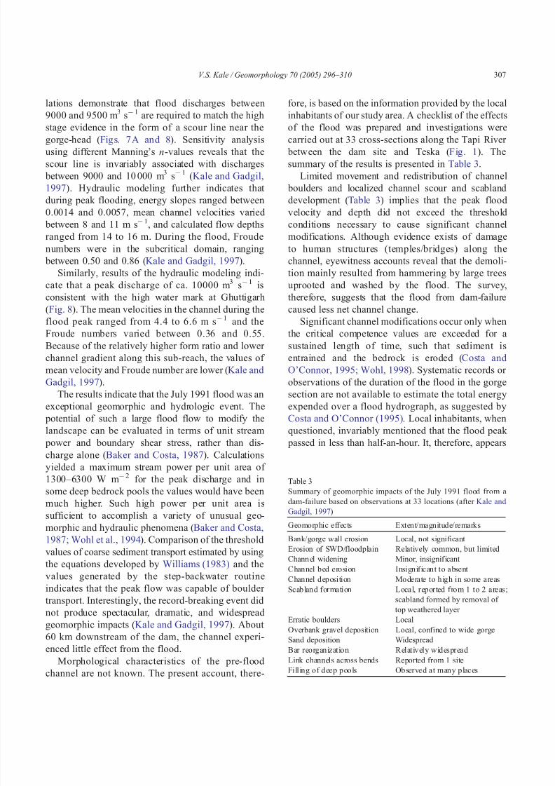
Limited movement and redistribution of channel
boulders and localized channel scour and scabland
development (Table 3) implies that the peak flood
velocity and depth did not exceed the threshold
conditions necessary to cause significant channel
modifications. Although evidence exists of damage
to human structures (temples/bridges) along the
channel, eyewitness accounts reveal that the demoli-
tion mainly resulted from hammering by large treesuprooted and washed by the flood. The survey,
therefore, suggests that the flood from dam-failure
caused less net channel change.
Significant channel modifications occur only when
the critical competence values are exceeded for a
sustained length of time, such that sediment is
entrained and the bedrock is eroded (Costa and
O’Connor, 1995; Wohl, 1998). Systematic records or
observations of the duration of the flood in the gorge
section are not available to estimate the total energy
expended over a flood hydrograph, as suggested by
Costa and O’Connor (1995). Local inhabitants, when
questioned, invariably mentioned that the flood peak
passed in less than half-an-hour. It, therefore, appears
Table 3
Summary of geomorphic impacts of the July 1991 flood from a
dam-failure based on observations at 33 locations (after Kale and
Gadgil, 1997)
Geomorphic effects Extent/magnitude/remarks
Bank/gorge wall erosion Local, not significant
Erosion of SWD/floodplain Relatively common, but limitedChannel widening Minor, insignificant
Channel bed erosion Insignificant to absent
Channel deposition Moderate to high in some areas
Scabland formation Local, reported from 1 to 2 areas;
scabland formed by removal of
top weathered layer
Erratic boulders Local
Overbank gravel deposition Local, confined to wide gorge
Sand deposition Widespread
Bar reorganization Relatively widespread
Link channels across bends Reported from 1 site
Filling of deep pools Observed at many places
V.S. Kale / Geomorphology 70 (2005) 296–310 307

7/27/2019 Kale_The-sinuous-bedrock-channel-of-the-Tapi-River,-Central-India-Its-form-and-processes_2005.pdf
http://slidepdf.com/reader/full/kalethe-sinuous-bedrock-channel-of-the-tapi-river-central-india-its-form-and-processes2005pdf 13/15
that the peak flood was characterized by short
duration and low total energy expenditure. This in
turn implies that the pre-flood bedrock channel
morphology of the Tapi River is largely adjusted inthree dimensions to geomorphically effective flows
that have a much longer return period. Evidently, the
July 1991 flood was not a threshold-passing flood for
bedrock erosion.
7. Discussion and conclusion
All the geomorphic activity is confined to the wet
season because of the seasonality of the flows in
monsoon areas. Along the Tapi Gorge, monsoonflows that exceed the threshold of boulder transport
and bedrock erosion are geomorphically effective.
Reconstruction of flood hydraulics implies that bed-
rock erosion in the resistant columnar basalts is
associated with rare, high-magnitude floods that
generate large values of total energy and exceed the
threshold of bedrock erosion. Even a flood from a
dam-failure that occurred in July 1991 could not
generate such conditions because the total energy was
low. It thus appears that the overall channel morphol-
ogy of the sinuous bedrock channel of the Tapi River
is adjusted to two types of thresholds: a threshold of
boulder-transport, which is associated with high-
magnitude floods that are competent to entrain
boulders but are incapable of bedrock erosion; and
another higher threshold of bedrock erosion, which is
exceeded by truly high-energy processes that generate
large total energy and exceed the threshold of bedrock
resistance. While the former threshold is exceeded
from time to time, the later threshold is exceeded only
episodically, with fairly long periods of no bedrock
erosion in between (Kale and Hire, 2004).
The incised bedrock channel of the Tapi River issinuous in planform. The channel reveals all the
characteristics of alluvial meandering channels. The
outer and the inner bends are characterized, respec-
tively, by scour pools and point bar deposits. The
location of bars, pools, and riffles is controlled by
the hydraulics of the flows. Most coarse gravel bars
are developed at the inside of bends because the
power per unit area declines in these locations
(Kelsey, 1988; Wohl, 1992; Baker and Kale, 1998).
Unlike the alluvial meandering channels, however,
the channel morphology appears to be strongly
related to infrequent large-magnitude floods because
only large floods are likely to be effective in terms
of erosion of the outer banks and transportation of coarse gravel.
An interesting aspect that has emerged during the
course of the present study is that within the bedrock
gorge the present channel is incised into coarse
gravel at some places. For instances, a large cobbly–
bouldery bar has been cut at Ghuttigarh (Fig. 6B),
indicating incision of rock to the present channel bed
level, followed by infilling of N10 m of coarse
gravel, and subsequent removal. Because stream
power is inversely related with channel width (Baker
and Costa, 1987), any increase in width associatedwith lateral erosion (particularly along the concave
banks) decreases the specific energy. The river is
compelled to incise into its own deposits and decrease
the width/depth ratio to maintain its hydraulic
efficiency and geomorphic effectiveness at a level
required to sustain water and sediment flux (Deodhar
and Kale, 1999).
The bedrock reach close to gorge-head (Reach-1),
with waterfalls (knick points), plunge pools, and large
boulder berms, falls in the zone of greatest concen-
tration of energy dissipation (Wohl, 1998). The
absence of inner channels and well-developed pot-
holes in this reach, however, is intriguing. The
channel is developed in horizontally layered bedrock
with differing erosional resistance. Sometimes it flows
over more resistant columnar basalts and sometimes
over less-resistant vesicular–amygdaloidal basalts.
According to some workers, under such situations
incising streams exhibit waterfalls or steep rapids at
the point of greatest incision, rather than inner
channels (Wohl, 1993). This explanation seems
unlikely in the present case, however, because a
well-developed inner channel in columnar basaltsexists several kilometers upstream of the gorge-head.
The meandering channel planform, the erosion
along the outer bends, deposition along the inner
bends and armoring of the channel bed by coarse
gravel imply that vertical incision is not the primary
activity under present hydraulic and gradient con-
ditions. Experimental studies by Shepherd (1972)
have demonstrated that sediment deposition at the
inside of the bends and erosion along the outer banks
is associated with a decrease in channel gradient
V.S. Kale / Geomorphology 70 (2005) 296–310308
7/27/2019 Kale_The-sinuous-bedrock-channel-of-the-Tapi-River,-Central-India-Its-form-and-processes_2005.pdf
http://slidepdf.com/reader/full/kalethe-sinuous-bedrock-channel-of-the-tapi-river-central-india-its-form-and-processes2005pdf 14/15
following intense vertical erosion. It appears that the
present gradient conditions do not favour channel
incision and downcutting. Preservation of early
Holocene flood deposits and thick gravel deposits at some places in Reach-2 supports this inference
because aggradation is unlikely if vertical erosion
and incision is the dominant process.
The tendency to meander and increase the sinu-
osity is a fundamental characteristic of some rivers
that are attempting to increase the flow resistance and
energy loss of high-magnitude events. The develop-
ment of a meandering pattern is one way to reduce the
energy expenditure of extreme discharges that are
competent to erode the channel bed and entrain coarse
gravel (Baker and Kale, 1998).The Tapi River provides an interesting example of
channel response in a high gradient, bedrock system
that is controlled by layered bedrock with differing
erosional resistance and is episodically subjected to
extreme discharges with large expenditure of total
energy.
Acknowledgement
The results presented in this paper are largely
based on studies carried out in connection with aresearch project undertaken by the author and
supported by the Indian Department of Science and
Technology, New Delhi. The author acknowledges
the support received from Pramod Hire and V.R.
Nagarale in the field. The author also thanks Paul
Carling, David Bridgland, and John Vitek for their
constructive and helpful comments.
References
Baker, V.R., 1977. Stream channel response to floods with examples
from central Texas. Geological Society of American Bulletin 88,
1057–1070.
Baker, V.R., 1988. Flood erosion. In: Baker, V.R., Kochel, R.C.,
Patton, P.C. (Eds.), Flood Geomorphology. Wiley, New York,
pp. 81 – 95.
Baker, V.R., Costa, J.E., 1987. Flood power. In: Mayer, L.,
Nash, D. (Eds.), Catastrophic Flooding. Allen and Unwin,
London, pp. 1–21.
Baker, V.R., Kale, V.S., 1998. The role of extreme floods in
shaping bedrock channels. In: Tinkler, K.J., Wohl, E. (Eds.),
Rivers Over Rock: Fluvial Processes in Bedrock Channels,
Monograph vol. 107. American Geophysical Union, Washing-
ton, DC, pp. 153–165.
Costa, J.E., O’Connor, J.E., 1995. Geomorphically effective floods.
In: Costa, J.E., Miller, A.J., Potter, K.W., Wilcock, P. (Eds.),
Natural and Anthropogenic Influences in Fluvial Geomorpho-
logy, Monograph vol. 89. American Geophysical Union,
Washington, DC, pp. 45–56.
Gupta, A., 1995. Magnitude, frequency, and special factors affecting
channel form and processes in the seasonal tropics. In: Costa,
J.E., Miller, A.J., Potter, K.W., Wilcock, P. (Eds.), Natural and
Anthropogenic Influences in Fluvial Geomorphology, Mono-
graph vol. 89. American Geophysical Union, Washington, DC,
pp. 125 – 136.
Deodhar, L.A., Kale, V.S., 1999. Downstream adjustments in
allochthonous rivers: Western Deccan Trap upland region,
India. In: Miller, A.J., Gupta, A. (Eds.), Varieties of Fluvial
Form. Wiley, Chichester, pp. 292 – 315.
Hack, J.T., 1973. Stream-profile analysis and stream-gradient index.U.S. Geological Survey Journal of Research 1, 421–429.
Hydrologic Engineering Centre, 1982. HEC-2 Water surface
profiles user’s manual, U.S. Army Corps of Engineers, Davis.
Kale, V.S., 2002. Fluvial geomorphology of Indian rivers: an
overview. Progress in Physical Geography 26, 400–433.
Kale, V.S., Gadgil, A.S., 1997. Evaluation of the flood hydrology in
the upper Tapi basin. Using Palaeoflood and historical records.
Project report submitted to the Department of Science and
Technology, New Delhi.
Kale, V.S., Hire, P.S., 2004. Effectiveness of large monsoon floods
on the Tapi River, India: role of channel geometry and
hydrologic regime. Geomorphology 57, 275–291.
Kale, V.S., Ely, L.L., Enzel, Y., Baker, V.R., 1994. Geomorphic and
hydrologic aspects of monsoon floods on the Narmada and TapiRivers in central India. Geomorphology 10, 157–168.
Kale, V.S., Mishra, S., Baker, V.R., 2003. Sedimentary records of
palaeofloods in the bedrock gorges of the Tapi and Narmada
rivers, central India. Current Science 84, 1072– 1079.
Kelsey, H.M., 1988. Formation of inner gorges. Catena 15,
433–458.
O’Connor, J.E., Webb, R.H., 1988. Hydraulic modeling for palae-
oflood analysis. In: Baker, V.R., Kochel, R.C., Patton, P.C.
(Eds.), Flood Geomorphology. Wiley, New York, pp. 393–402.
Ravi Shankar, 1991. Thermal and crustal structures of SONATA: a
zone of mid continental rifting in Indian shield. Journal,
Geological Society of India 37, 211–220.
Shepherd, R.G., 1972. Incised river meanders; evolution in
simulated bedrock. Science 178, 409–411.
Tinkler, K.J., 1971. Active valley meanders in south-central Texas
and their wider significance. Geological Society of America
Bulletin 82, 1783–1800.
Williams, G.P., 1983. Paleohydrological methods and some
examples from Swedish fluvial environments: I. Cobble and
boulder deposits. Geografiska Annaler 65A, 227 – 243.
Wohl, E.E., 1992. Bedrock benches and boulder bars: floods in the
Burdekin gorge of Australia. Geological Society of American
Bulletin 104, 770–778.
Wohl, E.E., 1993. Bedrock channel incision along Piccaninny
Creek, Australia. Journal of Geology 101, 749–761.
V.S. Kale / Geomorphology 70 (2005) 296–310 309

7/27/2019 Kale_The-sinuous-bedrock-channel-of-the-Tapi-River,-Central-India-Its-form-and-processes_2005.pdf
http://slidepdf.com/reader/full/kalethe-sinuous-bedrock-channel-of-the-tapi-river-central-india-its-form-and-processes2005pdf 15/15
Wohl, E.E., 1998. Bedrock channel morphology in relation to
erosional processes. In: Tinkler, K.J., Wohl, E. (Eds.), Rivers
Over Rock: Fluvial Processes in Bedrock Channels, Monograph
vol. 107. American Geophysical Union, Washington, DC, pp.
133–151.
Wohl, E.E., Greenbaum, N., Schick, A.P., Baker, V.R., 1994.
Controls on bedrock channel incision along Nahal Paran, Israel.
Earth Surface Processes and Landforms 19, 1–13.
Wolman, M.G., Miller, J.P., 1960. Magnitude and frequency of
forces in geomorphic process. Journal of Geology 68, 54–74.
V.S. Kale / Geomorphology 70 (2005) 296–310310