kashmir floods: rapid assessment peoples report 1
DESCRIPTION
This report is based on the discussion and interaction with different community network leaders and individuals. This report maps out the nature and extent of the disaster providing an overall picture of the situation in Kashmir.Young Kashmir Volunteers Alliance (YKVL)-an amalgam of various Kashmiri volunteer groups- who carried out relief and rescue work since September 7 have issued this rapid assessment report of Srinagar.TRANSCRIPT
Kashmir Floods: Rapid AssessmentPeoples Report 1This report is based on the discussion and interaction with different community network leaders and individuals. This report maps out the nature and extent of the disaster providing an overall picture of the situation in Kashmir
2014
Young Kashmir Volunteers Alliance YKVAS, Srinagar9/24/2014
Peoples Report - I
Kashmir Floods: A Rapid Assessment
This report is based on the discussion and interaction with different community network leaders and individuals. This report maps out the nature and extent of the disaster providing an overall picture of the situation in Kashmir
( A KVDFR and CSA report)
Disclaimer:
This report is a peoples report and the information presented here is collected by trained researchers mostly Ph.D scholars, MSW students and volunteers with multiple professional background. The data collected and findings evolved are the result of primary data which may contradict with other sources of data. Individuals and agencies are encouraged to take in consideration other perspectives on rapid assessment of Kashmir floods.

Abbreviations:
Contents

Part – 1
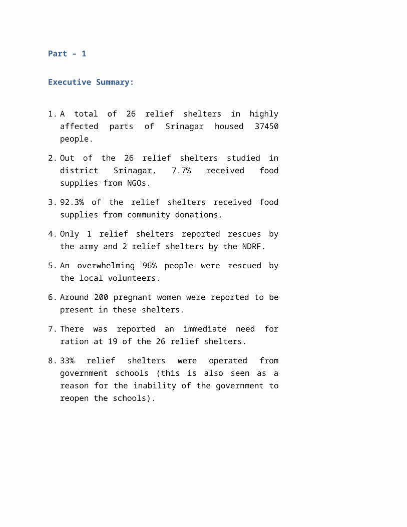
Executive Summary:
1. A total of 26 relief shelters in highly affected parts of Srinagar housed 37450 people.
2. Out of the 26 relief shelters studied in district Srinagar, 7.7% received food supplies from NGOs.
3. 92.3% of the relief shelters received food supplies from community donations.
4. Only 1 relief shelters reported rescues by the army and 2 relief shelters by the NDRF.
5. An overwhelming 96% people were rescued by the local volunteers.
6. Around 200 pregnant women were reported to be present in these shelters.
7. There was reported an immediate need for ration at 19 of the 26 relief shelters.
8. 33% relief shelters were operated from government schools (this is also seen as a reason for the inability of the government to reopen the schools).
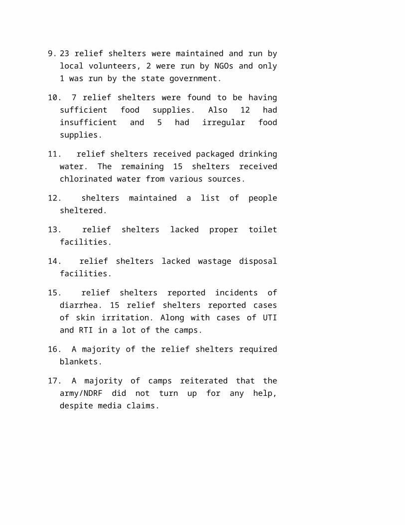
9. 23 relief shelters were maintained and run by local volunteers, 2 were run by NGOs and only 1 was run by the state government.
10. 7 relief shelters were found to be having sufficient food supplies. Also 12 had insufficient and 5 had irregular food supplies.
11. relief shelters received packaged drinking water. The remaining 15 shelters received chlorinated water from various sources.
12. shelters maintained a list of people sheltered.
13. relief shelters lacked proper toilet facilities.
14. relief shelters lacked wastage disposal facilities.
15. relief shelters reported incidents of diarrhea. 15 relief shelters reported cases of skin irritation. Along with cases of UTI and RTI in a lot of the camps.
16. A majority of the relief shelters required blankets.
17. A majority of camps reiterated that the army/NDRF did not turn up for any help, despite media claims.
Part – 2 Introduction
History and Memory of Floods in Kashmir
Valley of Kashmir is a basin surrounded by mountains measuring 130 Km SE by 40 Km NE. Valley is drained by five major rivers and numerous streams. River Jehlum, one of the major rivers of the valley cuts through a narrow gorge and exits near Baramulla district in north Kashmir. The total catchment area of Kashmir exceeds 1500 square kms and includes several snow fields and glaciers. The resulting discharge of river Jehlum is strongly dependent on seasons. In Past River Jehlum served as the chief means of transport for the valley and formed the lifeline of the trade and commerce in the valley. The massive floods that Kashmir has witnessed in the recently defy the serene image that Jehlum river otherwise presents.
Floods form an important part of Kashmir’s history. One of the earliest floods witnessed by Kashmiris and recorded in Tarikh-e-Hassan occurred in 833 A.D. According to this account the Valley of Kashmir was flooded after a massive earthquake triggered landslides, impounding river Jhelum. Villages and towns along the river Jehlum were obliged to keep the embankments of the river in repair. Many villages and towns had a strong community tradition of collectively repairing and maintaining river embankments. Walter Lawrence the settlement commissioner of Kashmir, who arrived in the valley in 1889
expressed his concern over the expansion of the capital city of Srinagar. He warned that the city was expanding towards the flood plain and was constantly exposing itself from the floods. The expansion of the city blocked the drainage system of the valley and was the major cause of floods. According to Lawrence the flood of 1893 had some positive effect on the state, as state geared itself to protect Srinagar city from inundation in future. For Lawrence, measures taken by the state towards protecting the city of Srinagar increased the future vulnerability of the city to the floods as it obstructs the passage of waters from south through the city. He observes that the founders of Srinagar have ‘bequeathed a serious engineering problem to the lower bed of the river at Baramulla’, regulating the water level of the valley by gates. Several proposals for control and management of floods were put forward by different agencies. Lawrence maintains that de-silting of Wular Lake, which is the natural delta of the river, should be a priority.
Urbanization and Infrastructure Development in Kashmir
In last one decade valley of Kashmir witnessed rapid urbanization and massive infrastructure development. Besides rapid urbanization, inauguration of elevated intra-Kashmir rail network in the year 2008 and an elevated highway continued to obstruct the passage of water from south through Srinagar. Population pressure on the water bodies and shrinking of wetlands that used to retain the excess flood waters in Kashmir further aggravated the situation. Construction of railway line along the flood plains worsened the flood situation in the areas located in and around the railway track. Reclamation of land for the elevated railway track and highway from the southern district of Anantnag to northern district of Baramula contributed to the shrinking of flood plains and also acted as a physical barrier. Unusually higher levels of inundation witnessed in some villages like Kakpora in Pulwama district, Nowgam and Lasjan in Srinagar may be attributed to the elevated railway track and highway. Rapid urbanization across Kashmir worsened the flood vulnerability in the Jehlum basin. Wetlands like Hokersar lost their capacity to retain excess flood water.
Wetlands conservation and hydrological cycles are strongly linked. Encroachment to wetlands affects the water retention capacity of wetlands and significantly impacts the levels of inundation. According to one estimate city of Srinagar lost twenty wetlands to the urban colonies during the last five days of urbanization and infrastructure development. There has been a massive upsurge in concretization of spaces in and around Srinagar. The impervious concrete spaces have increased from 30% in 1990 to 65% in 2010 severely affecting the hydrological processes. New housing colonies that were duly approved by the successive government authorities have been constructed on flood plains and have blocked the traditional drainage pattern and immensely contributed to the vulnerability of Srinagar city to floods and inundation1. In the absence of any pro-active strategy and lack of comprehensive disaster management plan state of Jammu and Kashmir remains vulnerable to all forms of disasters.
Chronology of the September Flood in Kashmir
Simultaneous western disturbance and disturbances in the Bay of Bengal resulted in heavy rains in parts of Jammu and Kashmir, on 2nd September, 2014. The Metrological department of Jammu and Kashmir predicted that rainfall will continue till 6th of September. On 3rd of September local dailies reported that threat of floods is looming large on the valley. As rains continued to pour incessantly, water levels in the major rivers of Jammu and Kashmir started to rise. The water levels in Chenab, Jhelum, Tawi and Sind rose threatening a spill over and breach. Alongside, water levels in the tributaries of Jhelum like Lidder, Toungri and Vaishav in South Kashmir were also rising considerably. On the same day Chief Engineer, flood control Kashmir declared a flood alert in the Southern districts of Kashmir like Anantnag, Kulgam and Pulwama. Educational institutions in the South were closed. Srinagar Jammu highway was closed down for traffic due to landslides. In Distirct Kulgam Vaishav Nallah raised havoc breaching its
1 Ramshoo, S, 2014 The 2014 Kashmir Flood: The Extreme of Extremes, http://www.greaterkashmir.com/news/2014/Sep/22/the-2014-kashmir-flood-the-extreme-of-the-extremes-30.asp
embankments and washing away many villages like Akhran and Aaaregutun.
After the reports came from District Anantnag that residential houses and cowsheds have been washed away by Jhelum in Verinaag and Dooru, the administration asked the people to move to safer places. On the 3rd itself the water in Jhelum touched the danger mark of 23 feet at Sangum, Anantnag.
On 4th of September, flood alert was declared all across Jammu and Kashmir. The water levels in Jhelum, Tawi and Chenab rose way above the danger mark. Reports of death and destruction started coming in all across Jammu and Kashmir. On 5th of September a bus carrying a marriage party was swept away on the Lam-Darhal road in Nowshera Tehsil of district Rajouri. In Rajouri as many as 70 houses collapsed and many more were damaged. Similarly in the Poonch district several hundred houses were damaged mainly in Surankot Tehsil.
As many as seventy villages in District Anantnag were submerged by the 5th of September. Flood water also entered areas of the township inundating Mattan Chowk, Dangerpora, Mehandi Kadal, Lal Chowk, Janglat Mandi, Achajipora, Moominabad, Iqbal Market, Bakshiabad, Laizbal, Anchidora, SK Colony, Achabal Adda, Naibasti and Khanabal. Many bridges were washed away rendering South of Kashmir totally cut off. In the meantime phone and mobile networks were completely down creating more panic. Many people in the south remained stranded with no information about their whereabouts.
Reports came from Shopian that Rambir Nallah has breached its embankments and village Kaprin and some other villages are inundated. Rambir Nallah breached in District Pulwama as well submerging Sarvan pur village in Kehlena. Towards the north in Tangmarag one more tributary of Jhelum; Nallha Ferozpora breached inundating the village Shrai Kunzar.
In Srinagar due to rains several areas like Safa Kadal, Eidgah, Nowshehra, Soura, Ali Jan Road, Gulshan Nagar, Mehjoor Nagar, Gogji Bagh, Wazir Bagh, Jawahar Nagar, Rajbagh and Bemina were
inundated. As the rains continued without any stopping Jhelum was already flowing at seven feet above the danger mark at Sangum in Anantnag and 4 feet above the danger mark at Ram Munshi Bagh in Srinagar. On 5th September River Jhelum started breaching its embankments and started spilling over at places like Lasjan, Armwari, Kanilpora, Pandrethan and Pantha Chowk. On the same day Srinagar Anantnag highway was declared unsafe for traffic. In the intervening night of 6th and 7th September while south Kashmir remained inundated and cut off with no connectivity whatsoever, the Jhelum breached its embankments all along the Srinagar city inundating the nerve center of Jammu and Kashmir. People in the city had been caught unawares. People ran for their lives to the upper stories of their houses in the dead of the night when some people say that it took 18 minutes for the water to fill the first story of their house. Lakhs of people were stranded and property worth billions under the water. On the morning of 7th September Indian TV channels flashed the news that Jammu and Kashmir is hit by the worst flood in its living memory. Red alert was sounded in the north of Kashmir in the districts of Bandipora and Baramulla. As the waters filled the Srinagar city inundating Shivpora, Indranagar, Rajbagh, Jawaharnagar Lal Chowk, Munawarabad, Bemina and many more areas, water took over Singhpora in Baramulla district 15 km from Srinagar and Sumbal in Bandipora district 15 km from Singhpora as well.
Politics of rescue and relief
Media plays a critical role in many aspects of crisis and disasters. The manner in which media frames a particular disaster is crucial to how various state and non-state actors would response to such disasters. Researchers have highlighted the ability of mass media to set the agenda influencing public policy and response to a particular disaster. In case of Kashmir floods the relief and rescue work was marred by the politicization of the disaster from the beginning. Despite the fact that the estimated initial cost of damage caused by floods in Jammu and Kashmir is close to one billion U.S dollars, Indian state refused to accept outside aid or assistance offered by international disaster relief
organizations. While disallowing aid and assistance from the International aid agencies, Indian Prime Minister offered to assist Pakistani state in relief and rescue work in Pakistani administered Kashmir. Sixty years of contestation in Kashmir cast its shadow over human tragedy that claimed hundreds of lives and damaged thousands of livelihoods. Indian media houses wasted no time in projecting Indian Army as “saviors of Kashmir’. Indian electronic media debated if the Indian Army relief and rescue work would be the turning point for Indian Army in Kashmir2. In the rescue operations carried by Indian Army, many locals accused Indian Army of discrimination. Several incidents of stone pelting on Army choppers and State government officials were reported in the local news papers3. Instead of humanizing events Indian media took a ‘command-post’ view of the whole situation in Kashmir4. They undermined the key role played by local community volunteers in rescue and relief and followed the official line. The farming of Kashmir flood and the response of armed forces to the human tragedy as ‘vindication’ of Indian Army’s position or as a turning point for Indian Army overshadowed the urgency for relief and rehabilitation.
2 Indian turns Kashmir flood disaster into PR stunt, dated: 20th September, http://america.aljazeera.com/opinions/2014/9/kashmir-floods-indiarescuereliefeffort.html
3 Anger Rises in India’s Kashmir as people remain trapped, Dated: 13th September, 2014 http://www.washingtonpost.com/world/anger-rises-in-indias-kashmir-valley-as-people-remain-trapped-a-week-after-floods/2014/09/13/975dc8ea-ed15-4d0f-a517-4c0ab71d3d0a
4 Wenger, Dennis, Thomas James and Charles Faupel (1980) Disaster Beliefs and Emergency Planning Newark: Disaster Research Center
Part -3
Methodology
This rapid assessment was conducted in consultation with civil society groups and activists in Kashmir. The site for data collection was the relief shelter. The details regarding the catchment area of a particular relief shelter was expected provide rapid assessment of the extent of the disaster. The assessment tools were prepared after deliberation and in due consultation with the civil society alliance of Kashmir. The assessment tool was prepared with following objectives:
1. To get an overall picture of the nature and extent of disaster in Srinagar city

2. To understand the nature and extent of response by different stake holders
3. To develop an inventory of resource persons engaged in disaster relief in the city of Srinagar
4. To map out areas affected by the floods in Srinagar city
5. To prepare an inventory of immediate requirements in the relief shelters
Sampling
Snowball sampling technique was used to seek information about the location of relief shelters in Srinagar city. In the snowball sampling technique the first contact persons in one of the relief shelters provided the addresses of other relief shelters and the respondents. Using this technique a sample of twenty six relief shelters was generated subsequently
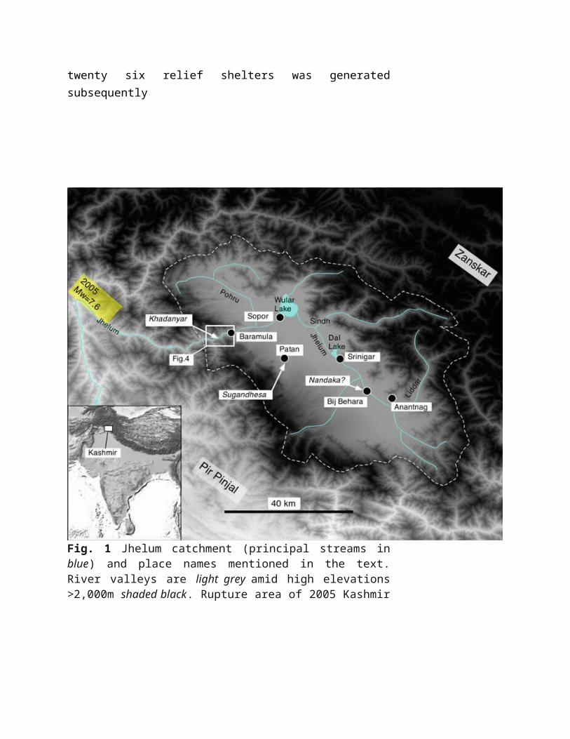
Fig. 1 Jhelum catchment (principal streams in blue) and place names mentioned in the text. River valleys are light grey amid high elevations >2,000m shaded black. Rupture area of 2005 Kashmir earthquake shadedyellow. Location of Fig. 4a, b indicated by box. (Source: Bali and Bilham, 2013)
.


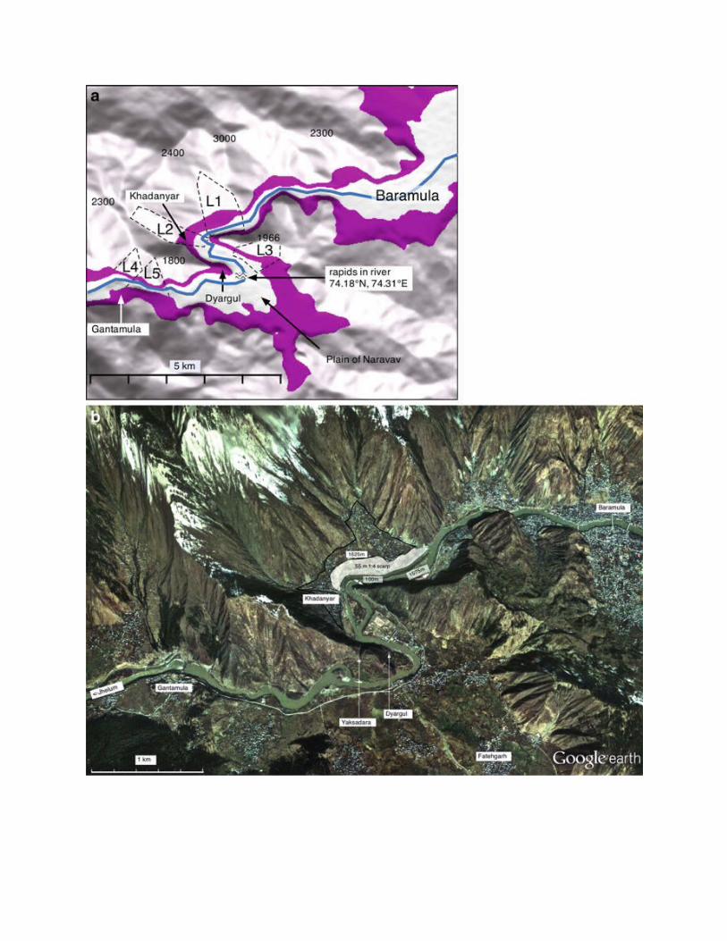
Fig 2 The path of the Jehlum downsream from Baramula with river terraces above 1.590m below 1,650mshaded. Constricted channels L1-L5
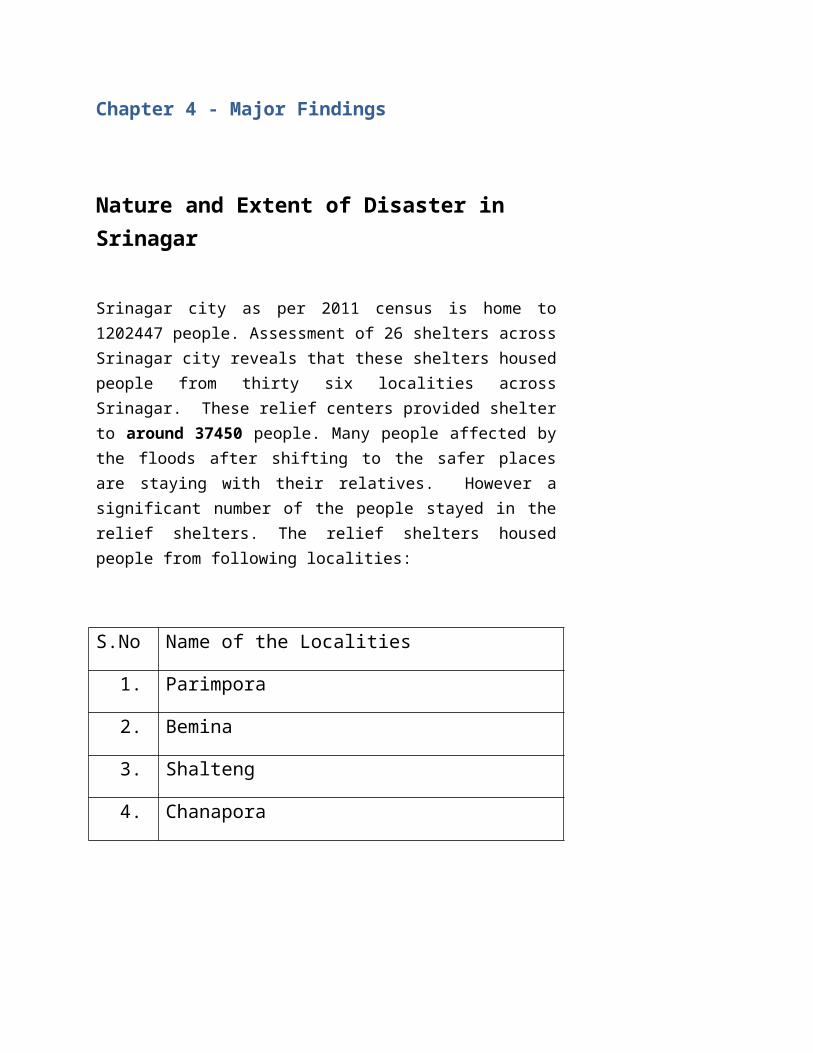
Chapter 4 - Major Findings
Nature and Extent of Disaster in Srinagar
Srinagar city as per 2011 census is home to 1202447 people. Assessment of 26 shelters across Srinagar city reveals that these shelters housed people from thirty six localities across Srinagar. These relief centers provided shelter to around 37450 people. Many people affected by the floods after shifting to the safer places are staying with their relatives. However a significant number of the people stayed in the relief shelters. The relief shelters housed people from following localities:
S.No Name of the Localities
1. Parimpora
2. Bemina
3. Shalteng
4. Chanapora
5. Mehjoornagar
6. Kursoo Rajbagh
7. Rajbagh
8. Jawahar Nagar
9. Rambagh
10. Tengpora
11. Batmaloo
12. Padshahi Bagh
13. Alochi Bagh
14. Sanat Nagar
15. Dal Lake
16. Indra Nagar
17. Palpora
18. Rainawari
19. Hazratbal
20. HMT
21. Bal Garden
22. GogjiBagh
23. Shivpora
24. Fruit Mandi
25. Umarabad
26. Tengpora
27. Tulsi Bagh
28. Malura
29. JVC
30. Nowgam
31. Peerbagh
32. Galwanpora
33. Mahraja Bazar
34. Natipora
35. Solina
36. Exhibition
Nature and Extent of response by different Stakeholders
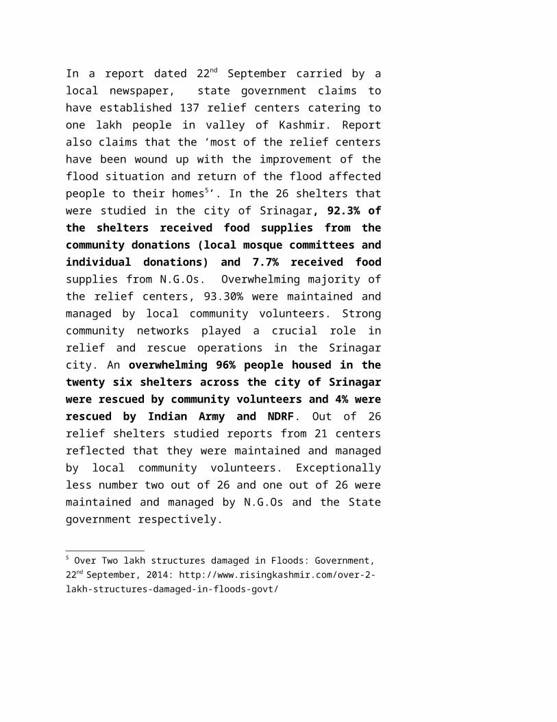
In a report dated 22nd September carried by a local newspaper, state government claims to have established 137 relief centers catering to one lakh people in valley of Kashmir. Report also claims that the ‘most of the relief centers have been wound up with the improvement of the flood situation and return of the flood affected people to their homes5’. In the 26 shelters that were studied in the city of Srinagar, 92.3% of the shelters received food supplies from the community donations (local mosque committees and individual donations) and 7.7% received food supplies from N.G.Os. Overwhelming majority of the
5 Over Two lakh structures damaged in Floods: Government, 22nd September, 2014: http://www.risingkashmir.com/over-2-lakh-structures-damaged-in-floods-govt/

relief centers, 93.30% were maintained and managed by local community volunteers. Strong community networks played a crucial role in relief and rescue operations in the Srinagar city. An overwhelming 96% people housed in the twenty six shelters across the city of Srinagar were rescued by community volunteers and 4% were rescued by Indian Army and NDRF. Out of 26 relief shelters studied reports from 21 centers reflected that they were maintained and managed by local community volunteers. Exceptionally less number two out of 26 and one out of 26 were maintained and managed by N.G.Os and the State government respectively.
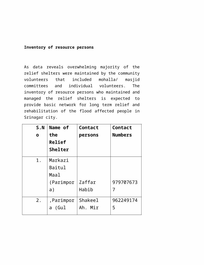
Inventory of resource persons
As data reveals overwhelming majority of the relief shelters were maintained by the community volunteers that included mohalla/ masjid committees and individual volunteers. The inventory of resource persons who maintained and managed the relief shelters is expected to provide basic network for long term relief and rehabilitation of the flood affected people in Srinagar city.
S.No Name of the Relief Shelter
Contact persons
Contact Numbers
1. Markazi Baitul Maal (Parimpora) Zaffar Habib 9797076737
2. ,Parimpora (Gul Bagh)
Shakeel Ah. Mir 9622491745
Dr. Abdul 9419005720
Rehman
3.
Shalteng
Dr Shuja Hussain 9906571942
Dr Javaid 990666236
4.Masjid Ibrahim, Bemina
Mr Ajaz 9697873474
Dr Syed Arif Hussain 9858476365
5. Shamsabad, Bemina
Ahmadullah Sahab 9596479777
6.
Rehmat Baitul Maal, Rawalpora
Abdul Latief 9858302795
Mohammad Younis 9906736277
Shahnawaz 9858742355
7. Gurduwara Shahid Banga, Baghat
Sarabjit Singh 9796849359
Bikram Singh 9419021375
Prof. SS Bali 9469132913
8.
Marriage Hall Sanatnagar
Mohammad Maqbool Tantray 9419014747
Mohammad Shafi 9858480539
9. Syed Hyder Baitul Mal,
Nazir Ah Dar 9419054223
Ghulam Hassan 9796572935

Rather
Ghulam Mohammad Bhat 9419084115
10.
Handwara Traders Federation, Rambagh
Aijaz Ah Sofi 9906418000
Abdul Rahim Mir 9797786103
Farooq Ahmed 9797802371
11.Community Center Goripora
Haji Ghulam Nabi Bhat 9419004968
Bilal Ahmed 9419064304
12.
J&K Yateem Foundation, Jawahar Nagar Bund
Mohammad Rafiq Lone 9622905881
Mohammad Ayoub Wani 9419520215
Bashmir Ah Bhat 9419922296
13.
Baitul Maal Solina Payeen
Ali Mohammad Khan 7298309136
Mubashur Bhat 8713957610
Mohammad Issaq 9796332205

14. Govt. Boys Higher Secodary School, Rainawari
Javaid Ahmed 9858736350
Gulshan 8803678020
15. GPM School, Rainawari
Bashir Ah Shahra 9419064902
16. Govt Girls Higher Sec School, Rainawari
Yasir 9797040047
Mohammad Ashraf 969795634
17. Govt Girls Sec School, Sonwar
Khursheed Ahmed 9419539872
18.Woodland High School, Sonwar
Shakeel Ahmed Malick 9697401540
Fayaz Malick 9906842671
19.
Muwest School, Rainawari
Tariq Ahmed 979622683
Wahid 9796533234
Bashir Ahmed 9086101057
20.
Kashmir University
Khalid 9419014763
Mir Imran 8803925217
Mohammad Shahid 959643808
Shabir Noorani 9858064970
21.
Habak Crossing
Mufti Nizammudin 9419003637
Fayaz Ahmed 7298531336
22. Boys Higher Secondary School, Lalbazar
Mohammad Shafi Jan 7298372234
23. Shah Kadal-Watal Kadal
Mohammad Afzal 9018368515
24.
Govt Higher Secondary School, Hazratbal
Ghulam Hassan Akhoon , 9596013877
Aijaz Ahmed 97971906514
Tassaduq Hussain Akhoon 9596250063
25. Gani Memorial Marriage Hall
Ghulam Dar 9419411862
Raees Ahmed 9796163828
26. Islamia High School, Rajouri Kadal
Professor Gilani 2429813
Situation Analysis of Relief shelters in Srinagar
Out of 26 relief shelters studied only seven shelters reported sufficient supply of food and rations. Eleven shelters received packaged drinking water and 15 shelters were using chlorinated water for drinking. Out of 26 shelters only 14 shelters had updated list of people housed in the shelters. Health and hygiene remains a major issue in majority of the relief shelters as 23 relief shelters reported lack of toilet facilities. 19 out of 26 relief shelters lacked proper wastage disposal mechanism. Thirty three percent of relief shelters were housed in schools significantly affecting the school education in Srinagar city. Two hundred pregnant women were reported from twenty six relief shelters across Srinagar. Majority of relief shelters reported the requirement of blankets. Seven relief shelters reported the incidents of diarrhea and fifteen shelters reported the incidents of skin irritation along with urinary tract infections. All relief shelters reported that Army/ NDRF did not come to their rescue despite desperate calls/requests.
92.3
7.7
Relief received from different sources
Local community resourcesN.G.Os
Percentage of people rescued by different stakeholders in the relief shelters across Srinagar
Army/NDRF NDRF Local Volunteers0
20
40
60
80
100
120
2 2
96