katni district - central ground water boardcgwb.gov.in/district_profile/mp/katni.pdf · water...
TRANSCRIPT

KATNI DISTRICT MADHYA PRADESH
Central Ground Water Board
North Central Region
Ministry of Water Resources
Government of India
BHOPAL
2013

KATNI DISTRICT AT A GLANCE S.N ITEMS Statistics
1 General Information
i) Geogeaphical area (sq.km)
ii) Administrative Divisions
Villages
iii) Population (As per Census 2011)
iv) Average Annual Rainfall (mm)
4504.11
948
1271684
1171.4
2 Geomorphology
i) Major Physiographic Units
ii) Major Drianage – Ganga & Narmada basir
Vindhyan Plateau, Denudation slope
Structural hills valleys of Bhitrigarh
ranges
Chhotimahandi, Katni Ken of Gangabati
Belkund & Suharrirors of Narmda barin.
3 LAND USE (Sq km)
i) Forest Area
ii) Net Area Sown
iii) Cultivable Area
1000
1927
2459
4 Major Soil Types Palaydlow, reddish brown & blacks oil
5 Area under Principal Crops Paddy, Wheat, Gram etc.
6 Irrigation by Different Sources
(Areas and Numbers of Structures) Number Area (Ha)
Dugwells 11008 301
Tube Wells / Borewells 921 12
Tanks / Ponds 2581 7
Canals 144 128
Other Sources 1623 151
Net Irrigated Area 492
Gross Irrigated Area 592
7. Number of Ground Water Monitoring Wells
of CGWB (As on 31.03.2013)
No. of Dug Wells
No. of Piezometers
18
01
8 Predominent Geological Formations Mahakoshals (Archaeans) Vindhyans,
Gondwans, Lamelas, Deccantaps, Katni
form lateriten & allumium.
9 Hydrology
Major Water Bearing Formation
(Pre-monsoon depth to water level during 2006)
(Post-monsoon depth to water level during 2006)
Long Term Water level trebd in 10 years (1997-
2006) in m/yr
Mahakoshals, Vidhyans, Gondwana,
Lamda, Katni & Allumium.
3.30-16.60 (m bgl)
0.20-8.55 (m bgl)
+0.02 to – 0.029 (Pre) m/year
- 0.03 to – 0.09 (Pre) m/year
10 Ground Water Exploration by CGWB (As on 31.03.2013)
No. of wells drilled (EW, OW, PZ, SH Total) 16 Ew + OW6+Pz4=26
11. Ground Water Quality
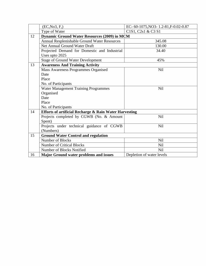
(EC,No3, F,) EC- 60-1075,NO3- 1.2-81,F-0.02-0.87
Type of Water C1S1, C2s1 & C3 S1
12 Dynamic Ground Water Resources (2009) in MCM
Annual Resplenishable Ground Water Resources 345.08
Net Annual Ground Water Draft 130.00
Projected Demand for Domestic and Industrial
Uses upto 2025
34.40
Stage of Ground Water Development 45%
13 Awareness And Training Activity
Mass Awareness Programmes Organised
Date
Place
No. of Participants
Nil
Water Management Training Programmes
Organised
Date
Place
No. of Participants
Nil
14 Efforts of artificial Recharge & Rain Water Harvesting
Projects completed by CGWB (No. & Amount
Spent)
Nil
Projects under technical guidance of CGWB
(Numbers)
Nil
15 Ground Water Control and regulation
Number of Blocks Nil
Number of Critical Blocks Nil
Number of Blocks Notified Nil
16 Major Ground water problems and issues Depletion of water levels

1.0 INTRODUCTION
Katni is a newly formed district, situated in the eastern past of Madhya Pradesh. It
came into existence by reorganization of Jabalpur districts in the year 2003. It is having
23.0% tribal population of the district. It is famous for its Cement & Lime Stone and &
Fireclay industries.
Katni district in surrounded by Satna in north-east, Umariya in the east, Jabalpur
& Damoh in the west & Panna in the north. The district lies between north latitude 23059’
and 24075’ and east longitude 79
057’ and 80
059’ falling in the Survey Of India Topo
Sheet No. 55M, 63 D, 64 A and 55 N.
The area of the district in 4504 sq. Km. It has been divided into four Tehsil and
six blocks (Fig-1). There are 911 villages and four towns in the district.
Details of administrative divisions of the district are given in table – 1
Table – 1 Administrative divisions, Katni district, M.P.
S.
N
Tehsil Block Area in Sq.Km. No. of towns
1. Mudwara 1 Rithi
2. Katni
3. Badwara
490.00
530.08
812.63
3
2. Vijayraghogarh 4.
Vijayraghogarh
668.74 1
3 Bahoriband 5 Bahoriband 933.25
4 Dhimarkheda 6 Dhimarkheda 784.59
Total 6 4504.11 4
Drainage :
Katni district falls under two river basins i.e. Ganga & partly in Narmda basin.
About 82% area of the district is drained by the Ganga basin. The Chhoti Mahanadi,
Katni & Ken rivers are the major rivers of this basin. Ken river flows towards north and
confluences with Yamuna nadi. Katni river flow easterly & confluences with Chhoti
Mahanadi near Hantola village of Chhoti Mahanadi takes turn towards east & ultimately
confluence with Son river of Ganga basin.
Irrigation :
Irrigation facilities in Katni district are under development stage only 30% of net
sown area is irrigated, and rest of the area in rain fed.
Surface water irrigation in the district is in developing stage ground water is the
main source of irrigation in the district out of total 594.49 sq.km. area, irrigated land is
320.15 sq.km. is irrigated from ground water sources, which in about 54.57% of total
irrigation in the district. There are 921 table wells & 11008 dug wells is the district for
irrigation.

CGWB Activities :
Shri M.A. Haseeb carried out systematic by Hydrogeological surveys in the
district 1976-78 S/Shri K.M. vishwanath & Sourabh Gupta, Junior Hydrogeologist
carried out systematic hydrogelogical surveys in the year 1988-89 & 89-90. S/Shri G.B.
Rao & Babu Nair carried out reappraisal hydro geological surveys in the year 1996-1997
& by Shri A.K. Badhauliya, Sr. Hydrogeologist in the year 1997-98. C.G.W.B. under
carried out exploration work during the year 1995-99.
2.0 CLIMATE AND RAINFALL
The climate of Katni district M.P. characterized by a summer and general dryness
except during the south west monsoon season. The year may divided into four seasons.
The cold season, December to February is followed by the hot season from March to
about middle of June. The period from the middle of June to September is the south west
monsoon season. October and November form the post monsoon or transition period.
The nearest Observatory is Jabalpur. The climatological parameters of Jabalpur is
used for analysis of rainfall. The average annual rainfall of Katni District is 1171.4 mm.
Katni district received maximum rainfall during south west monsoon period i.e. June to
September about 56.9% of the annual rainfall received during monsoon season. Only
13.1% of the annual rainfall takes place between October to May period. Thus surplus
water for ground water recharge is available only during the south west monsoon period.
The normal maximum temperature received during the month of May is 42.00c
and minimum during the month of Dec./January is 90C. The normal annual means
maximum and minimum temperature of Katni district is 320C & 18
0C respectively.
During the south west monsoon season the relative humidity generally exceeds 88%
(August month). In the rest of the year is driver. The driver part of the year is the summer
season, when relative humidity’s are less 31% May is the driest month of the year.
The wind velocity is higher during the pre-monsoon period as compared to post
monsoon period. The maximum wind velocity 8.2 km/hr observed during the month of
June and minimum 2.6 km/hr during the month of December. The average normal annual
wind velocity of Katni district is 4.9 km/hr. Normal climatologically parameter of Katni
district is given in attached annexure.
Normal Climatological parameters for Katni District.
S.
N.
Para meter Jan Feb Mar April May Jun July Aug Sept Oct Nov Dec Annul
1. Max. temp.
(0C )
26.2 29.4 34.5 39.3 42.0 38.0 31.1 29.8 31.4 32.3 29.9 26.
7
32.6
2. Minimum
temp.
(0C )temp
9.7 12.1 16.6 21.9 26.4 26.6 24.2 23.7 23.3 7.92 13.1 9.7 18.9
3. Relative temp
(%)
64 58 43 33 31 59 85 88 82 70 65 70 63
4. Wind Velocity
(Km/hr)
3.2 3.7 4.3 5.0 6.3 8.2 7.2 6.9 5.4 3.5 2.7 2.6 4.9

2.0 GEOMORPHOLOGY AND SOIL TYPES
Geomorphology
Katni district is predominantly hilly & forested. From geo-morphological point of
view, the district consists of series of mountains ranger & rivers. It can be divided into
three geo-morphological divisions.
1. Vindhyan plateau
2. Denudational slope & older flood plain
3. Structural hills & valleys of Bhitrigarh ranges.
In general, Katni district is characterised by hilly to undulating terrain with
altitude ranging between 400 m & 700 m. a mgl. The main high relief features of the area
are the Bahnder & Rampur ranger of Vindhyan Platean. Which form the north western
boundary of the district. North central part of the districts covered by denudation slope &
older flood plain along the Katni river form west to east directory an proterozone works.
The Bhitrighash ranger run across the southern part of the district from south west to
north east & represented by plateau, hills & valley it consists of metamorphic rock. As
per ITC classification system there are three groups of land form (a) Denudation b)
Depositional & c) Structural have been identified in the district.
Soils :
Soil of the district may be classified according to their physical property, the
crops grown and their position. The low lying area is occupied by pale yellow, reddish
brown & block soil.
Pale yellow is occupying alluvium, reddish brown is occupying the upper
Bhander sands tones & black soil is occupying the argillaceous sirbushaler. All the
agricultures fields are located over shales are covered by medium block soil & it
occuping the argillaceous. Sirbu shale All the agriculture field are located over shales are
covered by medium black soil it varies in the thickness from place to place from 1 to 4 m.
In the north of Katni town the area is occupied by alluvium the thickness of alluvium
varies from 20 to 50 m in depth.
4.0 GROUND WATER SCENARIO
Hydrogeology
Katni district is underlain by various geological formations, forming different
types of aquifers in the area. Main geological units of the area are, Archaean,
Mahakoshals, Vindhayan Super group, Gondwana super group, Lametas, Deccan traps,
Katni formation, Laterits and alluvium. Occurrence and movement of ground water in
hard rocks is mainly controlled by secondary porosity in Gondwana sand stone &
vesicular basalts in Deccan traps play an important role in ground water movement
lameta are also forming potential aquifers made up of relatively loose and friable shale &
sandstone. Ground water in general occurs under unconfined to semi-confined conditions.
The occurrence and movement of ground water in different geological formation is
described below.

Mahakoshal group (Archaean);
There rocks consisting of quartzite, shale, slate & marble are hard, compact,
recrystalised and have no primary porosity & form poor aquifer : However, limestone at
places have solution cavity resulting into very high secondary porosity & permeability
can yield 18 lps. water in wells. There formations are found in southern part of the district
in Dhimarkheda block the open wells existing in there formations can yield moderate
quantity of ground water. The yield depends upon the saturated thickness of weathered
mantle overlying the massive rock. The open wells have depth range between 9 to 15 m.
bgl. Generally column of water available during pre-monsoon season varies from 2 to 4
m. the general yield potential of Archaean formations in less than 3 lps.
Vindhyans : There are mostly sandstones and are devoid of primary porosity. However, due to
weathering, fracturing & Jointing the top position of formation behave as phreatic aquifer
due to development of secondary, porosity. There are poor yielding formation four the
ground water point of view both is phreatic & deep aquifer zone. There formations
occupied the northern part of the district in form of Kaimur ranger from west to east
covering major parts of Rithi, Beharibadn & Bijaraghogarh block. The depth of open
wells exists in this formation ranges from 8 to 15 m. bgl. The general yield potential of
vindhyans formation is less than 3 lps.
Gondwanas : There are sedimentary formation and are rich in granular zones forming
moderately potential aquifers. Gondwana sand stone. Support both tube wells & dug
wells and capable of yielding up to 5 to 16 lps of water for moderate drawdown of 4 to 8
m. There formation are occupying eastern parts of the district in Badwara & Katni blocks
& underlain by older alluvium.
Lametabeds :
This group consists of limestone, sand stone & days and lie uncontermably on the
older rock formations & are found usually underlying Deccan traps.
There formations occupying southern part of the district in Dhemarkheda block in
a narrow strip in the area. There beds are sandy containing chart, Jasper, pebble result
being a calcareous grit rather than limestone & having thickness of about 8 to 15 m. and
can yield poor to moderate discharge. Maeta gondwana contact can be explored for
moderately potential aquifers.
Deccan Traps : Deccan traps are very limited in the area in parts of Dhimar Kheda block. the
weathered, jointed, fractured & vesicular units of basalt form moderately potential
aquifer. These formations have highly variable yield, being higher in dug wells ranging
from 2 to 7 lps & generally increase with the depth.
Katni formation
These are horizontally disposed sequence belonging to Jabalpur bed of Gondwana
super group with thickness varying between 13 to 52 m. It consists of thin veneer of
ferruginous sediments and its base is conglomerate/pebbly ferruginous quarts wake with
bauxite. This formation is exposed above 380 m.amsl over the entire Katni vally. The

exploratory box wells in this formation have discharge from 3.5 to 7 lps. for 7.50 to 23 m.
of draw down.
Laterite :
It is most abundant in block of Katni area & transferred pebbles of these laterites
are seam at the base of Katni formation over the Jabalpur beds. This formation has poor
to moderate field ranging from 3 to 4 lps.
Alluvium :
The alluvial deposits are confined mostly along and around the river courses in
the Dhmarkheda & Baheriband blocks along Balkund & Suhar rivers. This is about 10 to
12 m. thick & has very good ground water potential zones which can field upto 10 lps of
discharge of ground water.
Depth to water level
Control ground board has been carrying out water level monitoring of ground
water monitoring wells (GWMW), form last two decades in the district. Water level of
these monitoring wells are being monitored four times in a year during the month of
January, May, August & November. A hydrogeological map of Katni district has been
prepared on the bases of available data. To study ground water regime of the area, pre &
post monsoon depth to water level maps of the district has been prepared. Northern part
of the district is highly undulating & forested. In this area these are a few ground water
monitoring wills for monitoring of water level.
Pre-Monsoon (May 2012)
In general depth to water level in the district, ranges between 3.30 m-16.60m bgl

Post monsoon (November 2012)
. In general depth to water level in the district, ranges between 0.20 m-10.00 m
bgl
Long term water level trend in last 10 years (Year 2003 to 2012)
During pre-monsoon period there is rise of 0.02-0.09 m/year and fall of 0.03 -0.09m/year.
Aquifer parameter
CGWB had drilled 13 exploratory wells in the district Hydrogelogical data of
exploratory wells is the district is given in Table 4 from the perusal of table 4 reveals that,
yield of Gondwana formations vary from 4.7' lps. to 15.71 lps,& draw down ranges
between 3.57 m to 8.44 m. the yield of Archean is between 2.66 of 3.0 lps for draw down
of 40.85 m. The yield of exploratory wells located in Vindhyaans are showing meager
discharger to 5.5 lps at Gulwara.
The Katani formation showing the yeild between 3.5 lps and 14.67 lps for draw
down between 21.48 m & 37.64 m. The exploration in cavernous limestone done at Kuan
the yield was formed 18 lps for 4 m. draw down only. Aquifer tapping in shale’s have
poor yield ranging from 1.5 lps to 5.5 lps.

Table 4: Hydrogeological details of CGWB exploratory wells drilled in Katni
district
S.
No.
Location Depth
Drilled
(M)
Zones tapped
(m)
Discharge
(lps)
W.L.M.
bgl
Draw
Down
(m)
Formation
1. Dharmapur
23013'45''
80017'55''
81.75 18.00-19.50
22.50-31.00
41.50-53.00
65.50-73.00
2.00 5.72 14.41 Clay Kankar
slate
2. Kolu Barkhera
23013'45''
80017'55''
77.30 52.00-61.00
64.00-67.00
70.00-73.00
3.50 5.32 21.48 Laterite, clay
sand, slate
3. Basari
23013'45''
80017'55''
80.00 36.00-39.00
41.00-43.00
45.00-51.00
56.00-59.00
61.00-63.00
5.25 9.7 8.44 Laterite,
sandstone
(Gondwana
shale)
4. IG Ward Katni
23013'45''
80017'55''
70.00 34.00-43.00
59.00-65.00
7.00 10.20 7.49 Laterie
sandstone
(Gondwana
clay&
limestone)
5. Khirhani
(Pipariya)
23013'45''
80017'55''
70.00 25.00-31.00
37.00-55.00
4.7 15.05 3.57 Clay sand
stone
(Gondwana)
6. Bramhanwara
(Kailwara)
23013'45''
80017'55''
70.00 50.00-70.00 14.67 6.16 37.64 Clay limestone
7. Barkhera
23013'45''
80017'55''
183.00 Abandoned meagre discharge
8. Lakha-Khera
23013'45''
80017'55''
92.8 17.00-30.00
33.00-38.00
52.00-62.00
15.71 12.41 4.05 Sandstone
(Gondwana)
9. Nadawar
23013'45''
80017'55''
95.00 33.00-42.00
51.00-60.00
2.6 9.31 36.37 Alluvium shale
10. Gulwara
23013'45''
80017'55''
135.2 44.00-75.00
134.00-135.00
5.5 6.37 22.91 Shale’s
11. Devri Hatai
23013'45''
80017'55''
183.00 44.00-48.50
119.00-122.00
146.00-152.5
2.66 51.00 408.85 Shale’s
12. Kuan
23013'45''
80017'55''
59.00 13.70-26.70
37.00-55.00
18.00 6.3 4.00 clay limestone
(cavernous)
13. Kauriya
23013'45''
80017'55''
82.00 35.00-37.00
43.00-44.50
1.50 12.85 19.00 shale’s

Ground Water Resources
Katni district is underlain by Vindhyan sandstone, Bijawar Alluvium and Basaltic
lava flows of Deccan trap and. Dynamic ground water resources of the district have been
estimated for base year -2008/09 on block-wise basis. Out of 4,89,400 ha of geographical
area, 4,66,648 ha ( 95 %) is ground water recharge worthy area and 22,752 ha (5%) is
hilly area. There are six number of assessment units (block) in the district which fall
under non-command (94 %) and command (6.%) sub units. All the blocks of the district
are categorized as safe. Vijairaghogarh block of the district with highest stage of ground
water development is computed as 63.3 % in Murwara (Katni). The net ground water
availability in the district is 35,5078 ham and ground Water draft for all uses is 15,457
ham, making stage of ground water development 45 % (37 % in 20030/4) as a whole for
district. After making allocation for future domestic and industrial supply for next 25
years, balance available ground water for future irrigation would be 18,067 ham.
Table 5 : Block Wise Ground Water Resource Estimation Data & Katni District
Annexure III D - (cont.) ASSESSMENT OF DYNAMIC GROUND WATER RESOURCES OF MADHYA PRADESH
Type of Assessment Unit : Block (As on March, 2009)
S. No. District/
Assessment
Unit
Sub-unit
Command/
Non-
Command/
Net Annual
Ground
water
Availability
(ham)
Existing
Gross
Ground
water
Draft for
Irrigation
(ham)
Existing
Gross
Ground
water
Draft for
Domestic
&
Industrial
water
Supply
(ham)
Existing
Gross
Ground
water
Draft
for All
uses
(11+12)
(ham)
Provision
for
domestic,
and
industrial
requirement
supply to
next 25 year
(2033)
(ham)
Net Ground
water
Availability
for future
irrigation d
development
(ham)
Stage of
Ground
water
Development
{(13/10)*100}
(%)
Katni
Badwara
Command 1329 126 19 145 45 1159 11
Non-Command 6393 3051 402 3453 518 2824 54
Block Total 7723 3177 421 3598 563 3983 47
Bohariband
Command 1300 55 41 96 65 1180 7
Non-Command 6101 2031 370 2402 587 3483 39
Block Total 7402 2086 411 2497 652 4664 34
DhimarKhrda
Command
Non-Command 4369 951 384 1335 493 31
Block Total 4369 951 384 1335 493 2926 31
Murwara
Command 1315 136 109 245 177 1002 19
Non-Command 4384 2523 322 2845 441 1420 65
Block Total 5699 2659 431 3090 618 2422 54
Rithi
Command 380 27 22 48 33 320 13
Non-Command 3516 1116 240 1357 387 2013 39
Block Total 3895 1143 262 1405 420 2333 36
Vijayraghogarh
Command
Non-Command 5419 2985 546 3531 694 1740 65
Block Total 5419 2985 546 3531 694 1740 65
District Total 34508 13000 2457 15457 3440 18067 45

Ground water quality of Katni district
Quality of Ground water for Drinking :
Ec,No3 and F value of ground water varies from 60-1075,1.2-81,0.02-0.87
respectively.High nitrate in the village area is appears due to excessive use of fertilizers
and agricultural waste. The total hardness of the ground water in the district is under safe
limit as per BIS standards.
Quality of water for irrigation
High SAR is not good for irrigation as it leads to Sodium Hazard. Water samples
in the district generally fall in C1S1, C2S1 and C3S`1 classes of US Salinity diagram.
However ground water in the district general is sage for irrigation but proper drainage
system is required where EC is more than 1500 us cm-1
.
Geogenic problems:
Fluoride in the district generally below 1.5 mgl-1, however groundwater in the
district is safe for drinking. More than 1.5mgl. Fluoride is responsible for bone
deformation. No arsenic has been detected in the district.
Status of ground water development
Ground water is main source for drinking of irrigation in the Katni district. About
54.57% of irrigation in the district is from ground water sources through level of
irrigation is the district is only 30% there are 910 tube wells and 10696 dug wells for
irrigation in the district. There are 13827 electric connections for agriculture purpose.
Depth of dug wells in the district ranger from 8 to 18 lps, depending on hydro geological
situations is the area. High yielding tube wells are found is the base wells located is
Gondwana sandstone and cavernous limestone.
A past from private sources, hand pumps are main source of rural water supply in
district and out of 911 villages 854 villages have tube wells/hand pump facility while 98
villages have piped water supply. Water supply of Katni town are form Katni river.

5.0 GROUND WATER MANAGEMENT STRATEGY
Ground water development
As per ground water resource estimation of Katni district for the year 2009, the
available ground water resources and gross ground water daft's are 345.08 MCM &
130.00 MCM respectively, making stage of ground water development 45% as a whole
for district. There is ample scope for future development of ground water resources is the
district. All six blocks namely Murwara, Vijayraghogarh, Badwara, Rithi, Bahoriband &
Dhimarkheda are falling under safe category. Decadal water level trend analysis reveals
mixed trend of water levels during pre & post monsoon seasons. After making allocation
for future domestic & industrial supply upto next 25 years, balance available ground
water at 50% stage of ground water development safe limits in Katni district would be
180.67 MCM, if 70% of balance available ground water resources is to be developed
through dug wells & 30% through tube wells, then at suitable hydro geological locations
tentatively 12000 new dug wells & 12000 new tube wells for irrigation can be
constructed in the district, considering unit draft of dug wells & tube wells 0.01 & 0.04
MCM respectively. Dug wells are feasible structure for granite area, whereat shallow
tube wells are recommended in weathered, jointed Archaeans. Deep tube wells with
proper wells assembly are suitable in Gondwana, Katni, Lametas & Alluvial formations.
In hard rocks i.e. raniter, Vindhyaur drilling may be taken up with DTH rigs. But in semi
-consolidated rocks, ie. Gondwana sandstones Katni formations, Lameta & alluvium the
drilling may be done by combination type of rig.
Water conservation and artificial recharge:
Considering hydro geological situation of the area, there is tremendous scope for
artificial recharges work especially is ground water depleting areas in all blocks. Plan
may be adopted using hill to valley approach is a watershed. At origin of streams
structures like gully plugs & contour trenches may be constructed to arrest surface run-
off & same water may be useful for soil moisture retention & development of vegetation
cover in the area. Gabion structures may be constructed at down stream of this structure,
across the stream using local boulders & wire mess to check the velocity of flowing
water, & to store water in upstream direction of these structures.
Percolation tanks are most important structure from ground water recharges point
of view. These are recommended is second & third order streams on porous & permeable
formations. Foundation of there percolation tanks should not rest on hard & compact or
on impregnable formation & water should be allowed to seep below streambed to
recharge ground water body at sub-surface.
It is quite possible that is due course of time infiltration of water from percolation
tanks is reduced due to silt deposition is side the structures.
To over come this problem recharge shafts may be constructed inside percolation
tanks to allow continuous seepage of water from the structures to ground water system of
the area. Recharge shafts are also have an advantage to hold water is tanks upto required
levels for local use.
Recharge shafts can also be constructed is those placer where impervious
formations are occurring at surface & at shallow depth porous & permeable rocks are

found, which may accepts water for recharge by constructing recharge shalk inside water
bodies of this type of situation, interconnection is made to reach water is underlying
porous & permeable formations occurring below impervious formation at shallow depth.
Properly designed tube wells also act as recharge shaft, if recharge of water is needed in
deeper aquifers overlain by impervious rocks.
Sub surface dykes are water conservation structure constructed at suitable hydro
geological sites across the river beds at the end of water shed to check sub surface flow of
water along stream beds. Trench is dug down to impervious horigon across the steams &
filled with local clay balls over high density polythene, making sub surface parser for
flow of water from stream beds.
Dug wells recharge is also applicable in rural areas. In this system water from
fields is diverted into recharge well passing through de-siltation chamber & filter media.
Filtered water reaches into recharge well through delivery pipe, lowered below water
level. at bottom of the well through delivery pipe to avoid checking of aquifer by entry of
bubbler.
In the urban areas the roof top rain water harvesting structure should be
implemented keeping local hydro geological setup of area in mind the suitable technique
should be adopted. Area recommended for ground water development potential &
artificial recharge is shown in fig. 6
6.0 GROUND WATER RELATED ISSUES AND PROBLEMS
Long term water level trend analysis shows mixed results. Depletion in ground
water levels is observed during both pre post monsoon seasons in ground water level
monitoring wells.
Though stage of ground water development of the district is only 45% even
though depiction of ground water levels indicates that ground water draft is exceeding the
recharge except the diction of ground water levels these is no major ground water related
issue & problem in the district.
7.0 AWARENESS AND TRAINING ACTIVITY
1 Mass awareness programme (MAP) & Water management training programme
(WMTP) by CGWB.
CGWB has not conducted any MAP & WMTP in Katni district.
2 Paticipation in exhibition, Mela, Fair etc.:
CGWB has not taken any participation in exhibition, Mela & Fair etc. in Katni
district.
3 Presentation & lectures delivered in public forum & Radio/T.V. etc.
CGWB has not done any activity in Katni district, under items mentioned above.

8.0 AREAS NOTIFIED BY CGWA/SGWA
In Katni district, no any area is notified by CGWB/SGWA
9.0 RECOMMENDATIONS
The stage of ground water development of Katni district is only 45% which
reveals adequate scope for future developments of ground water for irrigation. After
making allocation for future domestic & industrial water supply up to next 25 years is the
district, balance available ground water at 50% stage of ground water developments safe
limit would be 180.67 MCM. If 70% of balance available ground water is to be
developed through dug wells & 30% through tube wells/base wells, there tentatively
12000 new dug wells & 1200 new tube wells can be constructed for irrigation.
Depletion of ground water levels is recorded in ground water monitoring wells
therefore a plan for artificial recharge to be prepared so that important natural
resource is again used to recharge ground water system through feasible
techniques.
Conjunctive use of surface & ground water is recommended is the area.
There is high SAR value is some water samples which is not good for
irrigation as it leads to sodium hazard however is general ground water is safe for
irrigation but proper drainage system is required where EC is more than 1500 Us
cm-1 nitrate is the ground water of Katni (119 mgl/l) Saleemabad (211 mg/l) &
Barnhi (107 mg/l) GWM wells has been found in excessive than permissible
limits. Higher nitrate content in ground water is indicating anthropogenic
pothetion in ground water system of the area. Water from these stations should
not be used for drinking purpose.
Roof top rainwater harvesting tripe at should be implemented in urban areas of
Katni district.
---------------------------------------------------------------------------------------------------