narsinghpur district - central ground water...
TRANSCRIPT

NARSINGHPUR DISTRICT MADHYA PRADESH
Ministry of Water Resources Central Ground Water Board
North Central Region Government of India
2013

NARSINGHPUR DISTRICT AT A GLANCE
S.No. Items Statistics 1. General Information
Location
i) Geographical area
ii) Administrative Divisions (As on 2006)
Number of Tehsil/Blocks
Number of Panchayats/Villages
iii) Population (Census 2011)
iv) Normal Rainfall (mm)
Latitude (N) 22º45’- 23º15’
Longitude(E) 78º38’- 79º38’
5,125.55 km2
5/6
457/1086
1,092,141
1217.6
2. Geomorphology
1. Major Physiographic Units:
2. Major Drainage:
1. Southern Satpura hill range
2. Narmada Alluvium plain and
3. Northern Vindhyan Range
Narmada, Shakkar and Dudhi
3. Land Use (In Km2)
i) Forest area:
ii) Net area sown:
iii) Cultivable area:
342
3036.99
3884.15
4. Major Soil Types
Alluvium
5. Principal Crops
3884.15 km2
6. Irrigation By Different Sources No. Area irrigated km2
Dugwells 25913 929.75
Tube wells/Bore wells 4738 774.13
Tanks/Ponds 1 0.8
Canals 13 10.95
Other Sources - 0
Net Irrigated Area - 1769.10
Gross Irrigated Area) - 1851.70
7. Number of Ground Water Monitoring Wells of CGWB (As on 31.3.2013)
No. of Dug Wells
No. of Piezometers
19
5
8 Predominant Geological Formations
Alluvium, Deccan Trap basalts,
Gondwana , Vindhyan sandstone,
Bijawars and Archeans
9 Hydrogeology Major Water Bearing Formation
Pre-monsoon
depth to water level during 2012
Post-monsoon
depth to water level during 2012
Long Term water level trend in 10 years
Alluvium,Weathered/vesicular
basalt, flow contacts and fractured
sandstone.
4.15 – 18.6 m bgl
2.26 – 20.72 m bgl
Pre-monsoon

(2003-2012) in m/yr
0.6 m/annum Rise
Post-monsoon
0.08 – 0.3/annum fall
10. Ground Water Exploration By CGWB (As on 31.3.2013)
No of wells drilled (EW,OW,PZ,SH, Total) EW 77 OW 27 Pz 11
Depth Range (mbgl) 43 to 403.25
Discharge (liters per second) 0.20 to 52.42
Storativity 2.01x10⁻⁶
to 1.15 x10⁻³
Transmissivity (m2/day) 23- 2400
11. Ground Water Quality
Presence of Chemical constituents more
than permissible limit (e.g. EC, F, As, Fe)
EC: 297-1365µScm-1
NO3:8-74
F: 0.13-1.57
Type of Water potable
12 Dynamic Ground Water Resources (2009) in MCM
Net Ground Water Availability
Gross Annual Ground Water Draft………
Projected Demand for Domestic and
Industrial uses up to 2025………………
Stage of Ground Water Development….
1226.0
945.9
26.76
77%
13 Awareness and Training Activity
Mass Awareness Programmes organised
Water Management Training Programmes
Nil
Nil
14 Efforts of Artificial Recharge & Rainwater Harvesting
Projects completed by CGWB (No. &
Amount Spent)
Projects under technical guidance of
CGWB (Numbers)
Nil
Nil
15 Ground Water Control and Regulation
Number of OE Blocks
Number of Critical Blocks
Number of Semi Critical
Number of Notified Blocks
Nil 1-Narsinghpur
3- Chanwar Patha,
Ghotegaon and Kareli
Nil
16 Major Groundwater Problems and Issues
Declining water levels

1.0 INTRODUCTION
Narsinghpur district, spanning over an area of about 5126 km2, lies in the
south central part of the state of Madhya Pradesh. There are five tehsils fall under
this district namely Narsinghpur, Gotegaon, Gadarwara, Tendukheda & Kareli and
the district further divided into six administrative blocks namely Saikhera, Babai
Chichali, Chawarpatha , Kareli, Narsinghpur & Gotegaon .
The district is bounded by Seoni district on the southeast, Chhindwara in
South, Hoshangabad & Raisen in the west, Jabalpur in the northeast and Sagar in the
North. The district lies between North latitude 22o36’ and 23
o16
’ and east longitude
78o27’ and 79
o40’, falling in Survey of India topo sheet No. 55/I, 55/J, 55M & 55/N.
Narsinghpur is well connected with all parts of country by Rail and roads. It lies on
Mumbai- Varanasi and Bhopal - Bilaspur main railway line. National Highway no.12
, 26 and state Highway no.22 pass through the district. Important town and villages
are well connected by road.
The index map of Narsinghpur district is shown in Figure-1. As per 2011
census, the population of Narsinghpur district is about 1,092,141. For administrative
purposes the district has been divided into 5 tehsils and 6 blocks. It has five city
(Narsinghpur, Kareli, Gotegaon, Gadarwara & Babai Chichali), and 1052 villages.
The agricultural activity in Narsinghpur district is mainly dependent on the
monsoon. Irrigation aims at making good the deficiencies of rainfall, thereby bringing
more land under cultivation. At present the main source of irrigation in the district are
Canals & tubewells.
After the reorganization of states in 1956 there has been a gradual increase in
surface water Development.

.
Central Ground Water Board (CGWB) Activities-
In most of the parts of the district, comprehensive hydrogeological surveys
were conducted during 1984-85, 87-88 and 92- 93.
a- Sh. L.N. Mothgare, conducted systematic hydrogeological surveys in
district during 1984-85. Sh P. Srinivasan, conducted systematic
hydrogeological surveys in the remaining part of the district during 1987-
88. Reappraisal survey of the area was carried out by Sh. Parvinder Singh
and Ku. A.Bhatia during1992-93.
Fig 1

b- Central Ground Water Board has drilled 77 exploratory wells in the
district. all boreholes were drilled in alluvium, Basalt and sand stone
terrain.
c- In Narsinghpur district neither mass-awareness nor groundwater
management-training programme have been organized by CGWB.
2.0 RAINFALL AND CLIMATE
The climate of Narsinghpur district is generally dry except during the
southwest monsoon season. The year can be divided in to four seasons. The winter
commences from middle of November and lasts till the end of February. The period
from March to about first week of June is the summer season. May is the hottest
month of the year. The southwest monsoon starts from middle of June and lasts till
end of September. October and middle of November constitute the post monsoon or
retreating monsoon season.
The normal annual rainfall of Narsinghpur district is 1217.6mm.District
received maximum rainfall during south west monsoon period i.e. June to September .
About 91.3 % of the annual rainfall received during monsoon season. Only 8.7 % of
the annual rainfall takes place between October to May period. The rainfall forms the
sole source of the natural recharge to ground water regime and is mainly available
during the south west monsoon period only.
The normal maximum temperature received during the month of May is 42.50
C and minimum during the month of January is 8.20 C. The normal daily mean
monthly maximum temperature is 33.20 C and daily mean minimum temperature is
18.10 C.
The summer season is the driest period of the year. The relative humidity
generally exceeds 90% in the month of August. In the rest of year is drier. The driest
part of the year is summer, when relative humidity comes down lowest in 39% in the
month of April. It varies between 39% and 90% at different time in different seasons.
The wind velocity is high during the monsoon period as compared to pre and post
monsoon.
The wind velocity is highest in June around 8.0 km/hr and lowest is 2.0 km/hr
in November. The average normal annual wind velocity of the district is 4.2 km./hr.
Normal climatological parameter of Narsinghpur district is given below:
S.
N.
Parameter Jan Feb. Mar Apr. May June Jul. Aug Sep. Oct Nov. Dec Annual
1 Max.Tem 26.8 30.3 35.3 40.3 42.5 38.1 31.4 29.7 31.9 33.5 30.7 27.3 33.2
2 Min.Tem 8.2 11.1 15.6 21.4 25.9 26.1 23.9 23.1 22.5 17.9 12.4 8.6 18.1

3 Rela.Hum 74 64 50 40 39 66 85 90 84 70 70 76 67
4 Wind vel. 2.4 3 3.8 4.4 5.9 8 6.8 6 3.8 2.2 2.2 2 4.2
5 Rainfall 11 17.3 12.1 6.2 7 168.9 334.8 423.6 160.8 23.5 14.3 12.6 1192.1
.
3.0 GEOMORPHOLOGY & SOIL TYPES
Physiographically, the district area can be broadly divided into three sectors-
namely 1) Narmada Valley alluvial plain, 2) Satpura range in the south and 3) the
Vindhyan range in the north. The vast alluvial plain of Narmada valley stretches from
east to west throughout the district on both the sides of the Narmada river. The
regional slope of the area is westward.
Soil Characteristics
The areas in Northwest, East and Southeast of the district are generally
covered with black soils derived from Basaltic rocks varying in the depth
from 0.33m to over a meter. The soils are usually clayey to loamy in texture
with calcareous concretions invariably present They are sticky and in summers,
due to shrinkage, develop deep cracks . The soils predominantly consist of
montmorillonite and beidellite type of clay minerals.
In rest of alluvial areas , mixed clays , black , brown to reddish brown ,
derived from sandstones and basalt rocks are observed and are predominantly
sandy - clayey in nature with calcareous concretions .Near the banks of the
rivers and at river confluences ,light yellow to yellowish brown soils are
noticed which were deposited during the recent past .The se soils are clayey to
silty in nature . The soils near the foots hills are gravelly with good porosity .
4.0 GROUND WATER SCENARIO
4.1 Geology
The general geological successions in the district are given in table-4.
Table-1: General Geological successions of Narsinghpur district.
Age Stratigraphic
Unit
Lithology
Recent Pleistocene alluvium & soil cap

comprising clays, sand,
gravels etc.
---------------------- Unconformity -----------------------
Cretaceous to Eocene Deccan trap and
intertrappeans
Basaltic lava flows and
intertrappean bed comprising
red bole.
---------------------- Unconformity -----------------------
upper cretaceous Lametas sandstones, silt stones ,
limestones & Marls
Permian to upper
cretaceous
Upper
Gondwana
Jabalpur series,
(Jabalpur stage,
chaugan stage)
soft porous sandstones and
light coloured shales & clays
Mahadeva series
(Bagra stage &
Denwa stage)
pebble beds & conglomerates
white & yellow sandstones
and shales
---------------------- Unconformity -----------------------
upper
carboniferous to
Permian
lower
Gondwanas
Danuda series,
Barakar stage
white to lava coloured
sandstones & grits with
occasional conglomerates
and shales
Talchir series,
Talchir stage
green boulder with clays &
shales
---------------------- Unconformity -----------------------
Cambrian Vindhyan Upper Bhander
series
reddish purple to buff
coloured sandstones and
quartzites.
---------------------- Unconformity -----------------------
upper to middle
Precambrian
metamorphic calcareous
crystalline
quartzite
phylites & schist
bijawars
granitic gneiss
dolomite lime stone &
calcareous shales
quartz tic &cal-granulites
phylites & various schist
marbles and banded
ferrigenous quartzites
granites & granitic gneiss
4.2 Hydrogeology
Groundwater is the principal source of irrigation in the district and all the
alluvial deposits of Narmada valley in the district forms very potential
aquifers.Hydrogeological set up of the district is shown in Fig 2-
Aquifer System
The Archaean schists and phyllites form phreatic aquifers wherever
weathered /jointed . In general the aquifer systems in these rocks have poor
potential and very few dug wells are found in the areas occupied by Schist
\Phyllites . The yield of these dugwells range from 1 to 2 lps.

The dolomitic limestones of the Bijawars have a high potential and the
aquifer system formed by solution cavities and fractures /joints sustain a good
yield of the order of 7 lps, wherever solution cavities are encountered directly
e.g. around Chanwarpatha village , [55 I /16 ,55M /4 ] and a moderate potential
if the structure is located in jointed fractured rock . The yield of these
structures range from 3 to 5 lps.
The fractured Vindhyan sandstones and shales occurring in the northern
part of the district form poor phreatic aquifers and dug wells taping these
formations sustain only 2 to 3 hours of pumping daily . The Vindhyans
encountered in some bore holes at depth ranging between 50 to 80 m. bgl do
not form aquifers as such but their upper contact with overlying rocks yield 2
to 3 lps water .
The phreatic aquifers occurring in the southern part of the district are
formed by weathered zone of shales of Gondwana formations and fine to
medium grained Vindhyan sanstones. These aquifers have moderate potential . The
yield of the dug wells constructed in these aquifer systems range from 2 to 3 lps.
Gondwana formations occurring at depth below alluvium form confined
to semi-confined aquifers which are not very productive and yield less than 5
lps water . In the exploratory bore holes drilled by CGWB during Narmada
Project , granular zones in the Gondwana were encountered at Dabkia ,
Bikrampur , Dhamna , Singhpur etc.
The Lametas , occurring only in North Western part of the district are
weathered on surface and dug wells in the weathered portion yield a poor
discharge ranging from 1to 2 lps .
Deccan traps in the Northern part of the district overlie the Lametas
and occur at the hill tops where no ground water structure exists . However in
the South Eastern part of the district , Deccan traps form moderate to good
phreatic aquifers and dug wells sustain a good discharge ranging from 2 to 5
lps .
The alluvial aquifer system is most extensive one in the district . Two
to three and places more number of granular zones are encountered in the
alluvium ,comprising fine to medium to coarse grained sand ,gravel and kankar
separated by clay lenses .The upper phreatic aquifers in general ranges in
thickness from 2 to 10 m. and its top is encountered at a depth range of 5 to
20 m bgl . The yield of dugwells tapping the phreatic aquifer ranges
from 7.5 to 12 lps.

Fig 2

Aquifers Parameters
The results of the pumping tests show that the Transmissivity of the
alluvial aquifers tapped by dug wells ranges from 57 to 400 m2/day while the
hard rock aquifers have very low Transmissivity of the order of 19 m2/ day
Exploratory wells tapping multi-aquifer system . The Transmissivity of
these confined to semiconfined aquifers ranges from 23 to 2400
m2/day.Storativity values ranges from 2.01 x 10
–6 to 1.15 x10
–3 indicating
confined to semi confined nature of deep aquifers .
4.3 Water Levels
4.3.1 Pre-monsoon (May 2012)
The pre-monsoon depth to water level (figure-3) in Narsinghpur district ranges
between 4.15 mbgl to 18.60 mbgl. The major part of the district have water levels in
the range of 8 to 12 m bgl during the pre monsoon.
4.3.2 Post-monsoon (November 2012)
During post-monsoon period, November 2012, (figure-5) the water levels
varied from 2.26 to 20.72 m bgl. It is observed that the major part of the district was
covered by the water levels varying between 5 to 15 m bgl during the period.
Fig 3

4.2 Ground Water Resources
Narsinghpur district is underlain by Alluvium, Gondwana sandstone, Bijawar
and Basaltic lava flows of Deccan trap. Dynamic ground water resources of the
district have been estimated for base year -2008/09 on block-wise basis. Out of
5,13,300 ha of geographical area, 4,79,100 ha (93 %) is ground water recharge
worthy area and 34,200 ha (7 %) is hilly area. There are six number of assessment
units (block) in the district which fall under non-command (99 %-) and command
(1.%-Gotegaon) sub units. Chanwarpatha, Chichli, Gotegaon and Kareli (safe in
2003/04) blocks of the district are categorized as semi critical and Narsinghpur (safe
in 2003/04) as Critical. The highest stage of ground water development is computed
94 % in Narsinghpur block. The net ground water availability in the district is
1,22,600 ham and Ground Water Draft for all uses is 94,590 ham, making stage of
ground water development 77 % (63 % in 2003/04) as a whole for district. After
making allocation for future domestic and industrial supply for next 25 years, balance
available ground water for future irrigation would be 27,359 ham.
Table: Ground Water Resources of Narsinghpur District, M.P
S. No. Assessment
Unit
Sub-unit
Command/
Non-
Command/
Net
Annual
Ground
water
Existing
Gross
Ground
water Draft
Existing
Gross
Ground
water
Existing
Gross
Ground
water
Provision
for
domestic,
and
Net Ground
water
Availability
for future
Stage of
Ground
water
Development
Category
Fig 4
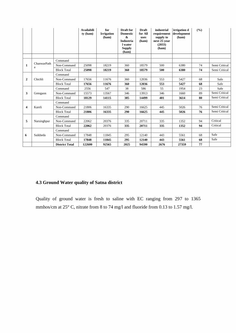
Availabili
ty (ham)
for
Irrigation
(ham)
Draft for
Domestic
&
Industria
l water
Supply
(ham)
Draft
for All
uses
(ham)
industrial
requirement
supply to
next 25 year
(2033)
(ham)
irrigation d
development
(ham)
(%)
1 ChanwarPatha
Command
Non-Command 25098 18219 360 18579 500 6380 74 Semi Critical
Block Total 25098 18219 360 18579 500 6380 74 Semi Critical
2 Chichli
Command
Non-Command 17656 11676 360 12036 553 5427 68 Safe
Block Total 17656 11676 360 12036 553 5427 68 Safe
3 Gotegaon
Command 2556 547 38 586 55 1954 23 Safe
Non-Command 15573 13567 346 13913 346 1660 89 Semi Critical
Block Total 18129 14115 385 14499 401 3614 80 Semi Critical
4 Kareli
Command
Non-Command 21806 16335 290 16625 445 5026 76 Semi Critical
Block Total 21806 16335 290 16625 445 5026 76 Semi Critical
5 Narsinghpur
Command
Non-Command 22062 20376 335 20711 335 1352 94 Critical
Block Total 22062 20376 335 20711 335 1352 94 Critical
6 Saikheda
Command
Non-Command 17848 11845 295 12140 443 5561 68 Safe
Block Total 17848 11845 295 12140 443 5561 68 Safe
District Total 122600 92565 2025 94590 2676 27359 77
4.3 Ground Water quality of Satna district
Quality of ground water is fresh to saline with EC ranging from 297 to 1365
mmhos/cm at 25° C, nitrate from 8 to 74 mg/l and fluoride from 0.13 to 1.57 mg/l.
