kazuo umezawa jaxa/eorc - · pdf filefrequency channel set is identical to that of amsr-e...
TRANSCRIPT

JAXAJAXA’’s Activities on Climate Updatess Activities on Climate Updates
Kazuo UmezawaJAXA/EORC
2020--21 February 2013, CEOS Working Group on Climate21 February 2013, CEOS Working Group on ClimateWMO HQs, Geneva, SwitzerlandWMO HQs, Geneva, Switzerland
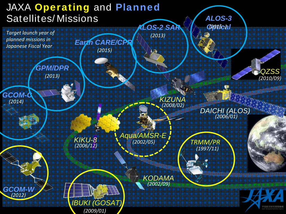
JAXA Operating and Planned Satellites/Missions
GCOM-C
GCOM-W
GPM/DPR
DAICHI (ALOS)
IBUKI (GOSAT)
Aqua/AMSR-E
(2009/01)
(2013)
(2012)
(2014)
ALOS-3 Optical(2015
‐)ALOS-2 SAR(2013)
KIKU-8
KIZUNA
Earth CARE/CPR(2015)
(2006/12)
(2006/01)
(2002/05)
(2008/02)
TRMM/PR(1997/11)
KODAMA(2002/09)
(2010/09)QZSS
Target launch year of
planned missions in
Japanese Fiscal Year
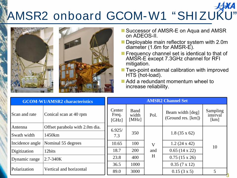
Successor of AMSR-E on Aqua and AMSR on ADEOS-II.
Deployable main reflector system with 2.0m diameter (1.6m for AMSR-E).
Frequency channel set is identical to that of AMSR-E except 7.3GHz channel for RFI mitigation.
Two-point external calibration with improved HTS (hot-load).
Add a redundant momentum wheel to increase reliability.
GCOM-W1/AMSR2 characteristics
Scan and rate Conical scan at 40 rpm
Antenna Offset parabola with 2.0m dia.
Swath width 1450km
Incidence angle Nominal 55 degrees
Digitization 12bits
Dynamic range 2.7-340K
Polarization Vertical and horizontal
AMSR2 Channel Set
Center Freq.[GHz]
Band width [MHz]
Pol. Beam width [deg](Ground res. [km])
Sampling interval
[km]
6.925/7.3 350
VandH
1.8 (35 x 62)
1010.65 100 1.2 (24 x 42)18.7 200 0.65 (14 x 22)23.8 400 0.75 (15 x 26)36.5 1000 0.35 (7 x 12)89.0 3000 0.15 (3 x 5) 5
3
AMSR2 onboard GCOM-W1 “SHIZUKU”
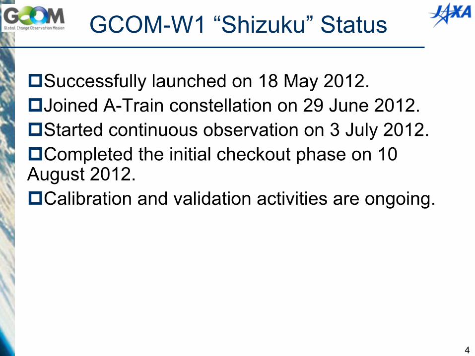
GCOM-W1 “Shizuku”
Status
Successfully launched on 18 May 2012.Joined A-Train constellation on 29 June 2012.Started continuous observation on 3 July 2012.Completed the initial checkout phase on 10 August 2012.Calibration and validation activities are ongoing.
4
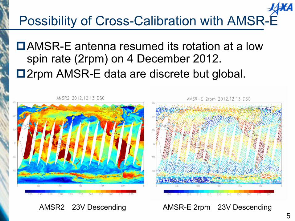
AMSR-E antenna resumed
its rotation at a low spin rate
(2rpm) on 4 December 2012.
2rpm AMSR-E data are discrete but global.
5AMSR2
23V Descending AMSR-E 2rpm
23V Descending
Possibility of Cross-Calibration with AMSR-E
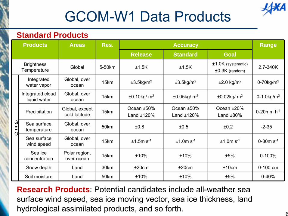
Products Areas Res. Accuracy RangeRelease Standard Goal
Brightness Temperature Global 5-50km ±1.5K ±1.5K
±1.0K (systematic)
±0.3K (random)2.7-340K
G
E
O
Integrated water vapor
Global, over ocean 15km ±3.5kg/m2 ±3.5kg/m2 ±2.0 kg/m2 0-70kg/m2
Integrated cloud liquid water
Global, over ocean 15km ±0.10kg/ m2 ±0.05kg/ m2 ±0.02kg/ m2 0-1.0kg/m2
Precipitation Global, except cold latitude 15km
Ocean ±50%Land ±120%
Ocean ±50%Land ±120%
Ocean ±20%Land ±80%
0-20mm h-1
Sea surface temperature
Global, over ocean 50km ±0.8� ±0.5� ±0.2� -2-35�
Sea surface wind speed
Global, over ocean 15km ±1.5m s-1 ±1.0m s-1 ±1.0m s-1 0-30m s-1
Sea ice concentration
Polar region, over ocean 15km ±10% ±10% ±5% 0-100%
Snow depth Land 30km ±20cm ±20cm ±10cm 0-100 cm
Soil moisture Land 50km ±10% ±10% ±5% 0-40%
GCOM-W1 Data Products
Research Products: Potential candidates include all-weather sea surface wind speed, sea ice moving vector, sea ice thickness, land hydrological assimilated products, and so forth.
Standard Products
6
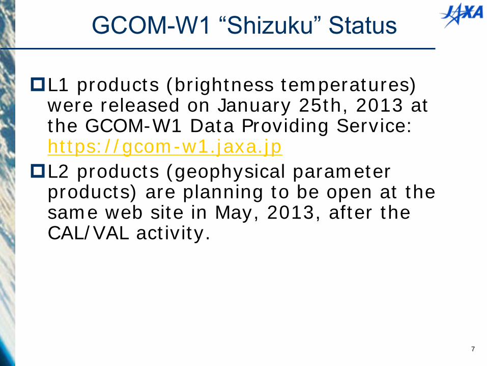
L1 products (brightness temperatures) were released on January 25th, 2013 at the GCOM-W1 Data Providing Service: https://gcom-w1.jaxa.jp
L2 products (geophysical parameter products) are planning to be open at the same web site in May, 2013, after the CAL/VAL activity.
7
GCOM-W1 “Shizuku”
Status
8
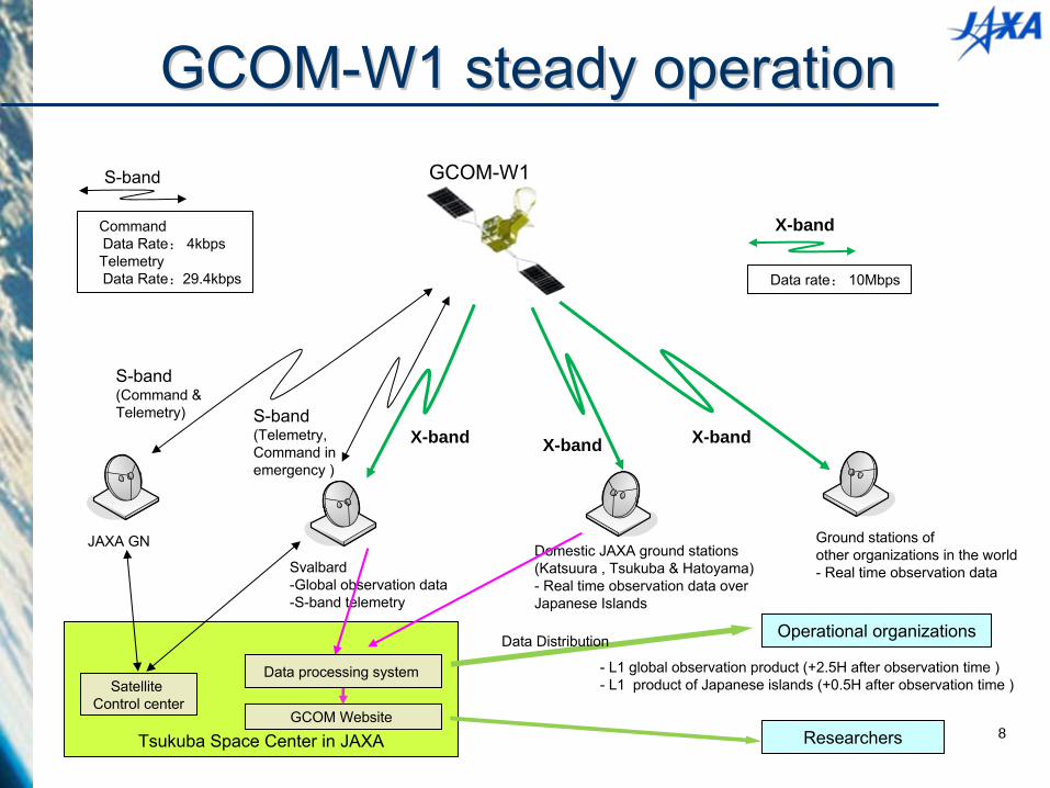
GCOMGCOM--W1 steady operationW1 steady operation
JAXA GN Domestic JAXA ground stations(Katsuura , Tsukuba & Hatoyama)-
Real time observation data over Japanese Islands
Svalbard-Global observation data-S-band telemetry
Ground stations of other organizations in the world-
Real time observation data
S-band(Command & Telemetry) S-band
(Telemetry, Command in emergency )
X-band X-band X-band
�CommandData Rate: 4kbps
�TelemetryData Rate:29.4kbps
S-band
�Data rate: 10Mbps
X-band
Tsukuba Space Center in JAXA
Satellite Control center
Data processing system
Operational organizations
GCOM-W1
Data Distribution
-
L1 global observation product (+2.5H after observation time ) -
L1 product of Japanese islands (+0.5H after observation time )
GCOM Website Researchers
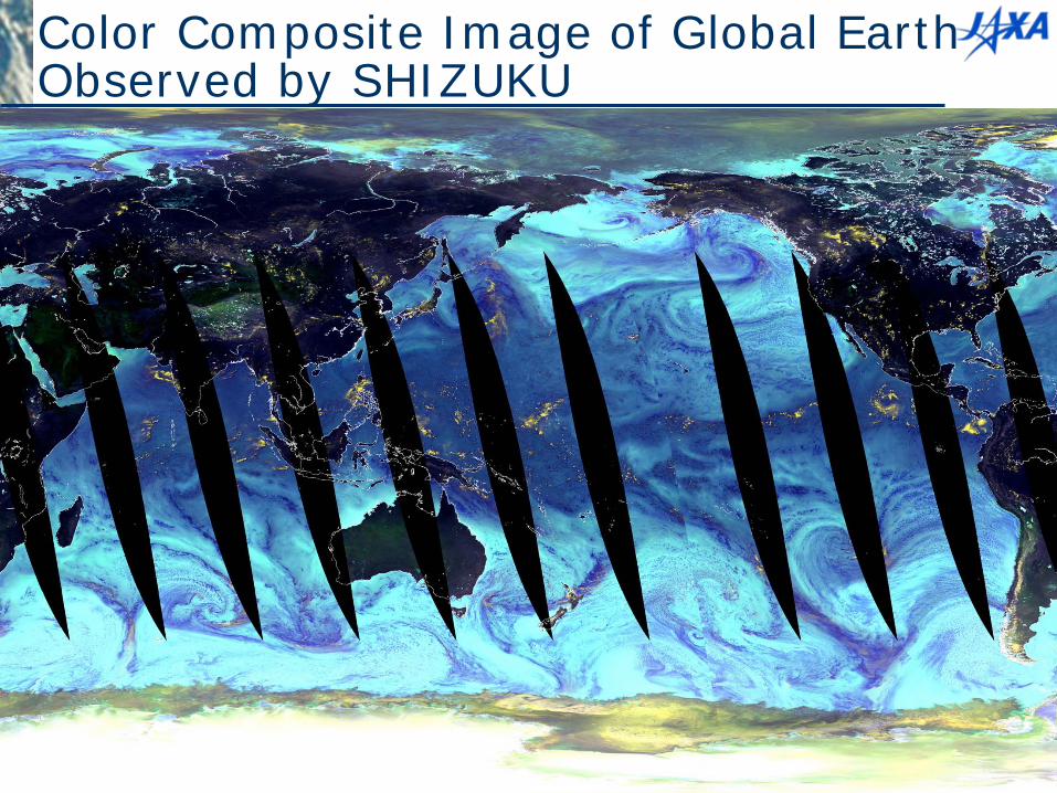
Color Composite Image of Global Earth Observed by SHIZUKU
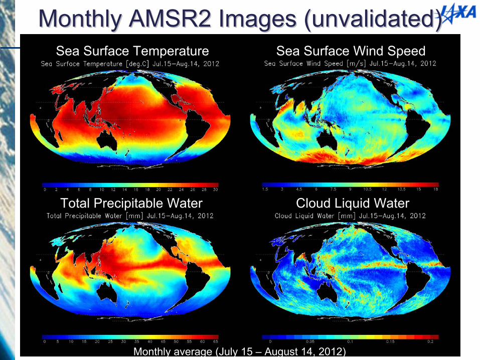
Sea Surface Temperature
Total Precipitable Water Cloud Liquid Water
Sea Surface Wind Speed
Monthly average (July 15 –
August 14, 2012)
Monthly AMSR2 Images (unvalidated)Monthly AMSR2 Images (unvalidated)
10
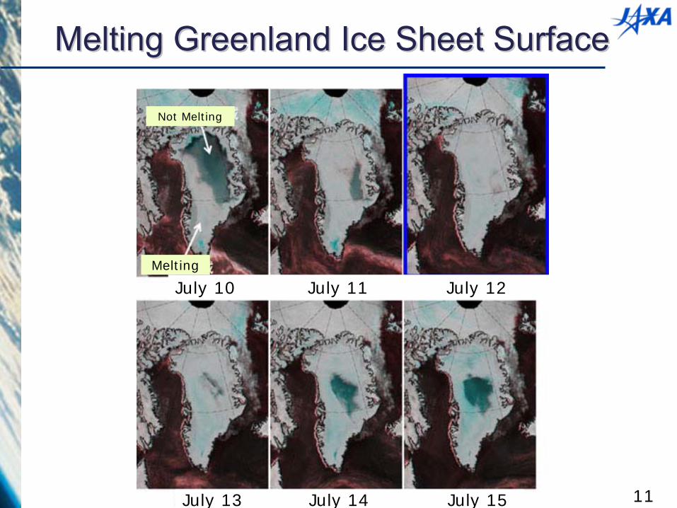
Not Melting
Melting
July 10 July 11 July 12
July 13 July 14 July 15
Melting Greenland Ice Sheet SurfaceMelting Greenland Ice Sheet Surface
11

AMSR-E
AMSR2
The 2nd smallest sea-Ice extent on Sep 24, 2007
Sea-Ice Extent in Arctic Region
http://www.ijis.iarc.uaf.edu/en/home/seaice_extent.htm
The smallest sea-Ice extent in recorded history on Sep 16, 2012
12
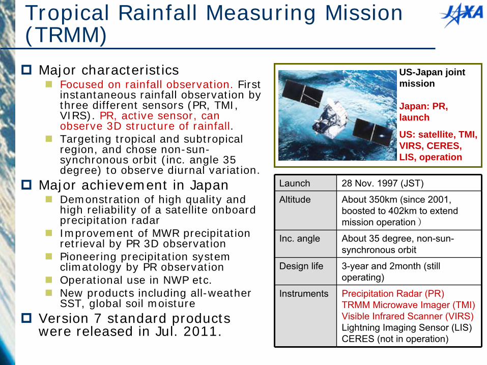
Tropical Rainfall Measuring Mission (TRMM)
Major characteristics
Focused on rainfall observation. First instantaneous rainfall observation by three different sensors (PR, TMI, VIRS). PR, active sensor, can observe 3D structure of rainfall.
Targeting tropical and subtropical region, and chose non-sun- synchronous orbit (inc. angle 35 degree) to observe diurnal variation.
Major achievement in Japan
Demonstration of high quality and high reliability of a satellite onboard precipitation radar
Improvement of MWR precipitation retrieval by PR 3D observation
Pioneering precipitation system climatology by PR observation
Operational use in NWP etc.
New products including all-weather SST, global soil moisture
Version 7 standard products were released in Jul. 2011.
Launch 28 Nov. 1997 (JST)
Altitude About 350km (since 2001, boosted to 402km to extend mission operation)
Inc. angle About 35 degree, non-sun-
synchronous orbit
Design life 3-year and 2month (still operating)
Instruments Precipitation Radar (PR)TRMM Microwave Imager (TMI) Visible Infrared Scanner (VIRS)Lightning Imaging Sensor (LIS)CERES (not in operation)
US-Japan joint mission
Japan: PR, launch
US: satellite, TMI, VIRS, CERES, LIS, operation

14
Greenhouse Gases Observing Satellite (GOSAT), Ibuki
Current Ground-based Observation Points (320pts) Provided by WMO WDCGG
Increase of Observation Points using GOSAT (56,000pts)
GOSAT enables global (with 56,000 points) and frequent (at every 3 days) monitoring CO2 and CH4 column
density. (Launched in Jan 2009)
TANSOTANSO--CAICAI(Cloud and (Cloud and Aerosol Imager)Aerosol Imager)
TANSOTANSO--FTSFTS (Fourier Transform (Fourier Transform Spectrometer)Spectrometer)

GOSAT “IBUKI” Status
Radiometric calibration on orbit in 4 years
Inter-comparison attempt with other TIR sensors of IASI and AIRS
Vicarious calibration field campaign with in-situ measurements and aircraft over-flight collaborated with NASA ACOS research
Annual degradation monitoring at uniform desert sites
Data distribution
Data products are distributed through the GOSAT User Interface Gateway (GUIG), a website for GOSAT data distribution
Prior user registration is required for accessing the data products and can be done on "user authentication" page reached from "product & service" page on GUIG. https://data.gosat.nies.go.jp/GosatUserInterfaceGateway/guig/GuigPa
ge/open.do;jsessionid=0F6497855D3B130F97D71E3D2BEC9323?lang =en
15
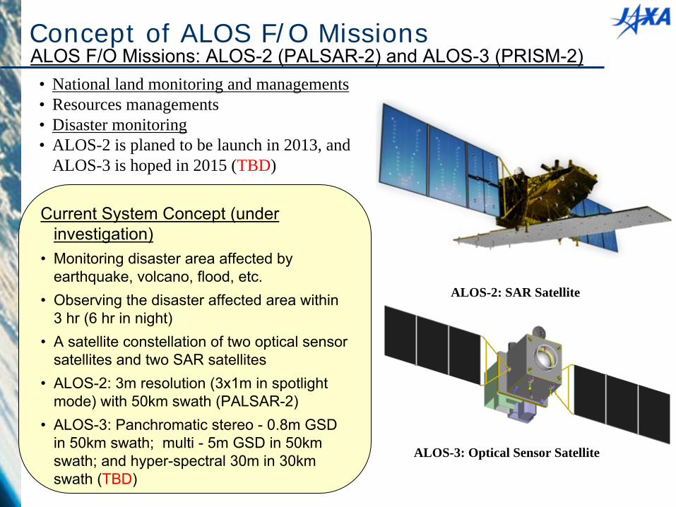
ALOS-3: Optical Sensor Satellite
ALOS-2: SAR Satellite
ALOS F/O Missions: ALOS-2 (PALSAR-2) and ALOS-3 (PRISM-2)
Current System Concept (under investigation)
•
Monitoring disaster area affected by earthquake, volcano, flood, etc.
•
Observing the disaster affected area within 3 hr (6 hr in night)
•
A satellite constellation of two optical sensor satellites and two SAR satellites
•
ALOS-2: 3m resolution (3x1m in spotlight mode) with 50km swath (PALSAR-2)
•
ALOS-3: Panchromatic stereo -
0.8m GSD in 50km swath; multi -
5m GSD in 50km swath; and hyper-spectral 30m in 30km swath (TBD)
Concept of ALOS F/O Missions
• National land monitoring and managements• Resources managements• Disaster monitoring • ALOS-2 is planed to be launch in 2013, and
ALOS-3 is hoped in 2015 (TBD)
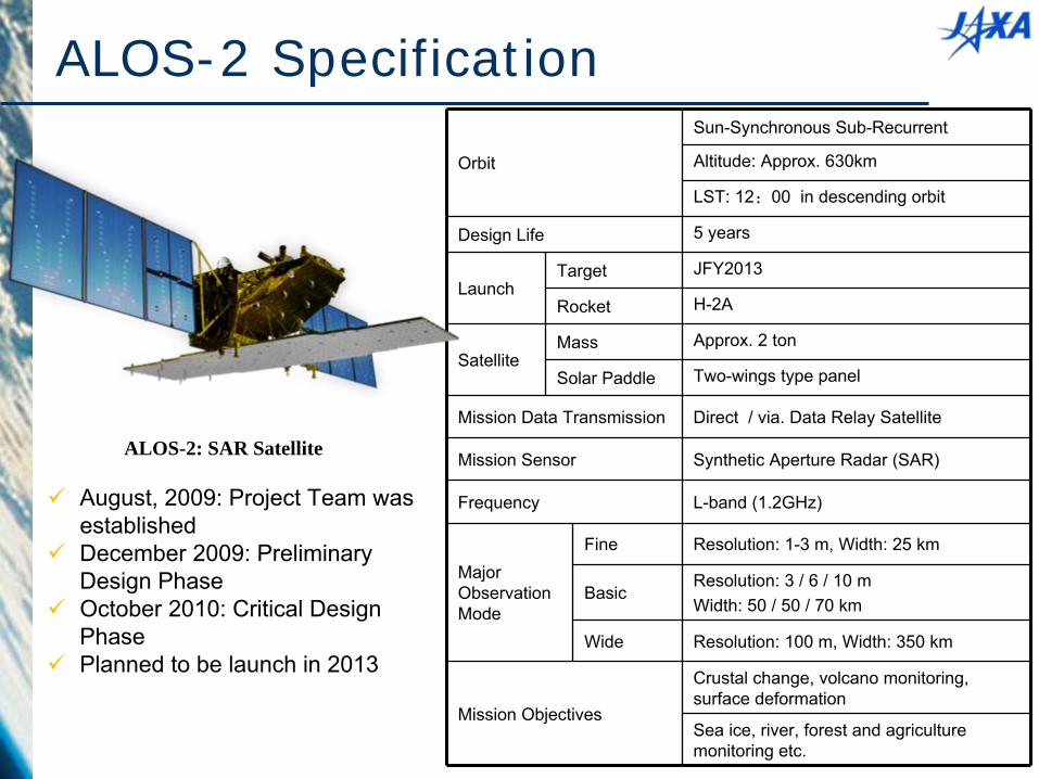
ALOS-2 Specification
ALOS-2: SAR Satellite
Orbit
Sun-Synchronous Sub-Recurrent
Altitude: Approx. 630km
LST: 12:00 in descending orbit
Design Life 5 years
LaunchTarget JFY2013
Rocket H-2A
SatelliteMass Approx. 2 ton
Solar Paddle Two-wings type panel
Mission Data Transmission Direct / via. Data Relay Satellite
Mission Sensor Synthetic Aperture Radar (SAR)
Frequency L-band (1.2GHz)
Major Observation Mode
Fine Resolution: 1-3 m, Width: 25 km
BasicResolution: 3 / 6 / 10 mWidth: 50 / 50 / 70 km
Wide Resolution: 100 m, Width: 350 km
Mission Objectives
Crustal change, volcano monitoring, surface deformation
Sea ice, river, forest and agriculture monitoring etc.
August, 2009: Project Team was established
December 2009: Preliminary Design Phase
October 2010: Critical Design Phase
Planned to be launch in 2013

Global Precipitation Measurement (GPM)
GPM Core ObservatoryObjective: Understanding the horizontal and
vertical structure of precipitation system Drop size distribution
measurement Improvement of precipitation rate
accuracy with constellation satellites
•
DPR
(JAXA, NICT)
(13.6, 35.5 GHz)
•
GMI (NASA)•
Launch in early 2014 by H-IIA•
Non-Sun-synchronous orbit, inclination: 65deg., altitude: 407 km
Constellation SatellitesObjectives: Observation frequency Science, social
applications•
Cooperation with constellation providers; JAXA
(GCOM-W), CNES/ISRO (Megha-
Tropiques), NOAA, etc.
•
3 hourly observation of 80% of the globe.
•
Launch around 2013 by each organization
•
Mainly sun-synchronous orbit with altitude 600~800 km
Generation and dissemination of global map of precipitation rate with high frequency and accuracy
GPM/DPR Status
DPR was shiped to NASA GSFC in mid March, 2012
After completion of the post shipment test, DPR was delivered to NASA on March 30, 2012.
DPR was integrated to GPM core observatory in April & May, 2012.
Complehensive performance test #1 (CPT #1, which is the initial functional and performance test) was performed in September & October, 2012.
Pre-Environmental Review (PER) was successfully completed in October, 2012.
Joint PI Workshop of Global Environment Observation Mission
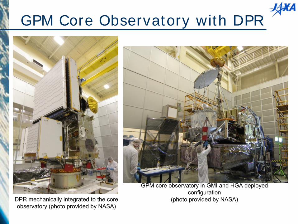
GPM Core Observatory with DPR
DPR mechanically integrated to the core observatory (photo provided by NASA)
GPM core observatory in GMI and HGA deployed configuration
(photo provided by NASA)
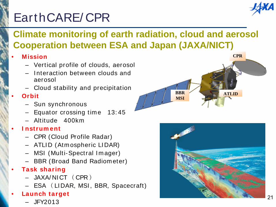
CPR
ATLIDBBRMSI
EarthCARE/CPR
• Mission– Vertical profile of clouds, aerosol– Interaction between clouds and
aerosol– Cloud stability and precipitation
• Orbit– Sun synchronous– Equator crossing time 13:45– Altitude 400km
• Instrument– CPR (Cloud Profile Radar)– ATLID (Atmospheric LIDAR)– MSI (Multi-Spectral Imager)– BBR (Broad Band Radiometer)
• Task sharing– JAXA/NICT (CPR)
– ESA (LIDAR, MSI, BBR, Spacecraft)• Launch target
– JFY2013
Climate monitoring of earth radiation, cloud and aerosolCooperation between ESA and Japan (JAXA/NICT)
21

EarthCARE/CPR Status CPR completed its EM phase. The test results
were mostly as expected. Flight Model will be in the specification.
Ground Segment completed Preliminary Design Review, and under preparation towards CDR. GS materializes easy to use data distribution system named “G-Portal” for general users.
Preparation for use of products are discussed in International workshops and Tools for GCM users named “J-Simulator” was officially released.
EarthCARE is expected for 2015 launch. However schedule will be finalized at CPR-CDR and Satellite CDR, in March and in September, respectively.
22
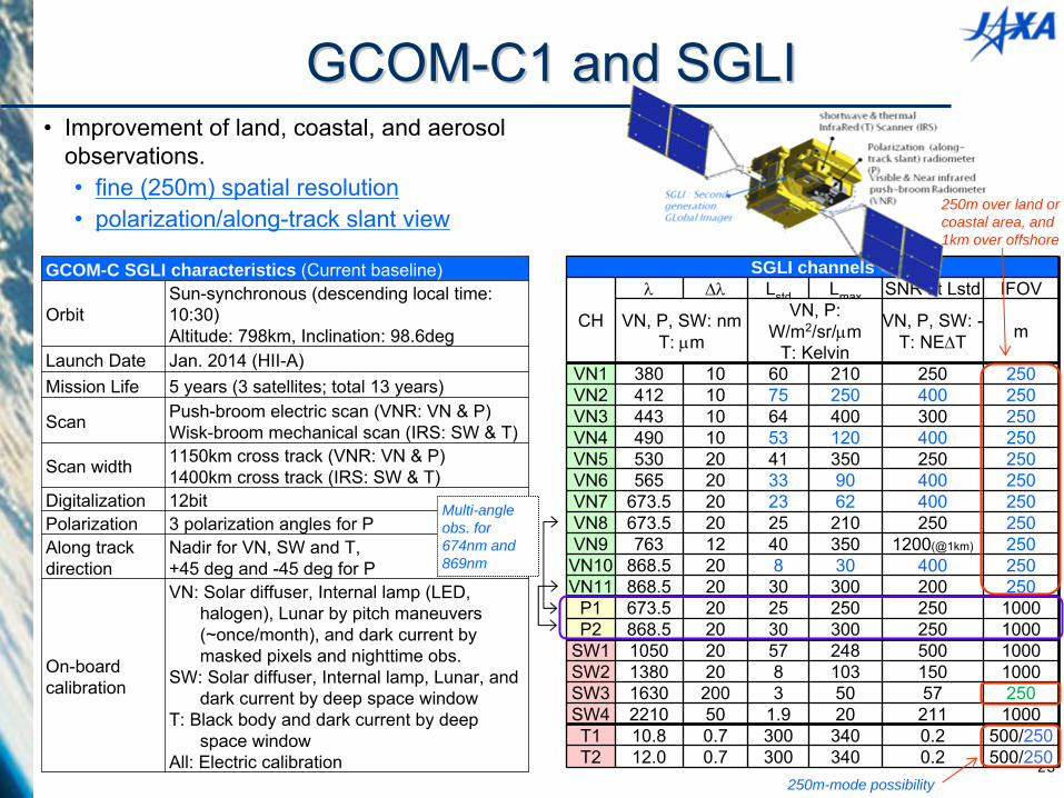
23
SGLI channels
CH
Lstd Lmax SNR at Lstd IFOV
VN, P, SW: nmT: m
VN, P: W/m2/sr/m
T: Kelvin
VN, P, SW: -T: NET m
VN1 380 10 60 210 250 250VN2 412 10 75 250 400 250VN3 443 10 64 400 300 250VN4 490 10 53 120 400 250VN5 530 20 41 350 250 250VN6 565 20 33 90 400 250VN7 673.5 20 23 62 400 250VN8 673.5 20 25 210 250 250VN9 763 12 40 350 1200(@1km) 250
VN10 868.5 20 8 30 400 250VN11 868.5 20 30 300 200 250
P1 673.5 20 25 250 250 1000P2 868.5 20 30 300 250 1000
SW1 1050 20 57 248 500 1000SW2 1380 20 8 103 150 1000SW3 1630 200 3 50 57 250SW4 2210 50 1.9 20 211 1000T1 10.8 0.7 300 340 0.2 500/250T2 12.0 0.7 300 340 0.2 500/250
•
Improvement of land, coastal, and aerosol observations.•
fine (250m) spatial resolution•
polarization/along-track slant view
GCOM-C SGLI characteristics (Current baseline)
OrbitSun-synchronous (descending local time: 10:30)Altitude: 798km, Inclination: 98.6deg
Launch Date Jan. 2014 (HII-A)Mission Life 5 years (3 satellites; total 13 years)
Scan Push-broom electric scan (VNR: VN & P)Wisk-broom mechanical scan (IRS: SW & T)
Scan width 1150km cross track (VNR: VN & P)1400km cross track (IRS: SW & T)
Digitalization 12bitPolarization 3 polarization angles for PAlong track direction
Nadir for VN, SW and T, +45 deg and -45 deg for P
On-board calibration
VN: Solar diffuser, Internal lamp (LED, halogen), Lunar by pitch maneuvers
(~once/month), and dark current by masked pixels and nighttime obs.
SW: Solar diffuser, Internal lamp, Lunar, and dark current by deep space window
T: Black body and dark current by deep space window
All: Electric calibration
Multi-angle obs. for 674nm and 869nm
250m over land or coastal area, and 1km over offshore
250m-mode possibility
GCOMGCOM--C1 and SGLIC1 and SGLI
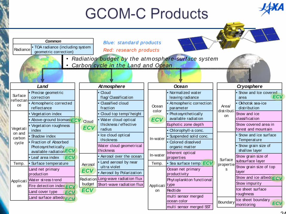
Land
Surface reflectan
ce
•Precise geometric correction
•Atmospheric corrected reflectance
Vegetati on and carbon cycle
•Vegetation index•Above-ground biomass•Vegetation roughness
index•Shadow index•Fraction of Absorbed
Photosynthetically available radiation
•Leaf area indexTemp. •Surface temperature
Applicati on
Land net primary productionWater stress trendFire detection indexLand cover typeLand surface albedo
Atmosphere
Cloud
•Cloud flag/Classification
•Classified cloud fraction
•Cloud top temp/height•Water cloud optical
thickness /effective radius
• Ice cloud optical thickness
Water cloud geometrical thickness
Aerosol
•Aerosol over the ocean •Land aerosol by near
ultra violet •Aerosol by Polarization
Radiation budget
Long-wave radiation flux Short-wave radiation flux
Cryosphere
Area/ distributi
on
•Snow and Ice covered area
•Okhotsk sea-ice distribution
Snow and ice classificationSnow covered area in forest and mountain
Surface propertie
s
•Snow and ice surface Temperature
•Snow grain size of shallow layer
Snow grain size of subsurface layerSnow grain size of top layerSnow and ice albedoSnow impurityIce sheet surface roughness
Boundary Ice sheet boundary monitoring
Common
Radiance •TOA radiance (including system geometric correction)
Ocean
Ocean color
•Normalized water leaving radiance
•Atmospheric correction parameter
•Photosynthetically available radiation
Euphotic zone depth
In-water
•Chlorophyll-a conc.•Suspended solid conc.•Colored dissolved
organic matter
In-water Inherent optical properties
Temp. •Sea surface temp.
Applicati on
Ocean net primary productivityPhytoplankton functional typeRedtidemulti sensor merged ocean colormulti sensor merged SST
Blue: standard products
Red: research products
•
Radiation budget by the atmosphere-surface system•
Carbon cycle in the Land and Ocean
ECV
ECV
ECV
ECVECV
ECV
ECVECVECV
ECVECV
ECV
ECV
ECV
24
The engineering model (EM) tests have been performed.
System structure model test was finished.
System thermal balance test was finished.
SGLI EM tests are being performed in a sensor level.
The subsystem CDR’s are on-going.The system CDR will be planned to be held in February 2013.
GCOM-C1 status
25

Thank you for your attention