ken denman wildlife area management plan department of fish and wildlife executive summary the ken...
TRANSCRIPT
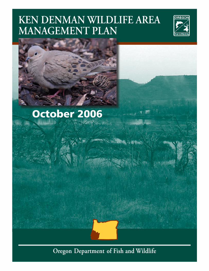
KEN DENMAN WILDLIFE AREA MANAGEMENT PLAN
Oregon Department of Fish and Wildlife
October 2006
Oregon Department of Fish and Wildlife
Roy Elicker, Director
Prepared by:
Vince Oredson, Ken Denman Wildlife Area ManagerNancy Breuner, Habitat Biologist
Oregon Department of Fish and Wildlife
Table of Contents
Executive Summary..............................................................................1Introduction ...........................................................................................1
Purpose of the Plan ..............................................................................1Oregon Department of Fish and Wildlife Mission and Authority .....1Purpose and Need of Denman Wildlife Area ....................................2Wildlife Area Goals and Objectives ....................................................2Wildlife Area Establishment ................................................................3
Description and Environment ...........................................................3Physical Resources ................................................................................3
Location ............................................................................................3Climate ..............................................................................................3Topography and Soils .......................................................................4Habitat Types ....................................................................................4Description of Tracts ......................................................................10
Biological Resources...........................................................................11Birds.................................................................................................11Mammals.........................................................................................12Amphibians and Reptiles................................................................12Fish...................................................................................................12Species of Conservation Concern ..................................................13Non-Native Species ........................................................................15
Monitoring .........................................................................................17Cultural Resources..............................................................................18Social Environment ............................................................................19
Demographics ................................................................................19Land Use..........................................................................................21
Infrastructure ......................................................................................21Developments/Facilities ........................................................................21
Water Rights ......................................................................................21Easements/Access Agreements ..........................................................21
Land Acquisition and Adjustment .................................................22Public Use .............................................................................................22
Public Access .......................................................................................22Hunting, Trapping, and Angling .......................................................22Non-consumptive ...............................................................................24Educational/Interpretive ...................................................................24
Objectives and Strategies.................................................................24Plan Implementation .........................................................................29
Funding...............................................................................................29Staffing/Organization .......................................................................29Compliance Requirements ................................................................30Partnerships .......................................................................................30Adaptive Management ......................................................................30Plan Amendment and Revision .........................................................30
References .......................................................................................... 31
Oregon Department of Fish and Wildlife
Appendices.................................................................................... 32 Appendix A. Land Acquisitions and Adjustments Involving the Ken Denman Wildlife Area.
Appendix B. .......................................................................................... 32Plant Species Known to Occur on the Ken Denman Wildlife Area.
Appendix C. ......................................................................................... 35Wildlife Species Known to Occur on the Ken Denman Wildlife Area.
Appendix D. ..........................................................................................38 State and Rogue River Valley Irrigation District Water Rights on the Ken Denman Wildlife Area.
Appendix E. .......................................................................................... 39Easements and Access Agreements on the Ken Denman Wildlife Area.
Appendix F. ........................................................................................... 40Legal Obligations Influencing Management of the Ken Denman Wildlife Area
Appendix G. .......................................................................................... 41 Band Recoveries of Ducks Banded at the Denman Wildlife Area
List of FiguresFigure 1.1 Ken Denman Wildlife Area Features and Ownership.Figure 1.2 Bear Creek Tract Features and Ownership.Figure 2. Habitat Types within Ken Denman Wildlife Area.Figure 3. Land Uses Surrounding Ken Denman Wildlife Area.
List of TablesTable 1. Habitat Types and Approximate Acreages on the Ken Denman Wildlife Area.
Table 2. Federal and State Listed Endangered, Threatened, Candidate and Species of Concern animals and plants potentially present on the Ken Denman Wildlife Area.
Table 3. Non-native Wildlife Species that may be found on the Ken Denman Wildlife Area.
Table 4. Non-native Fish Species that may be found on the Ken Denman Wildlife Area.
Table 5. Noxious Weeds Listed by the Oregon Department of Agriculture that may be found on the Ken Denman
Wildlife Area.
Table 6. Estimated Annual Hunting, Trapping, and Angling Use Days on the Ken Denman Wildlife Area.
Table 7. Estimated Annual Non-consumptive Use Days on the Ken Denman Wildlife Area.
Oregon Department of Fish and Wildlife
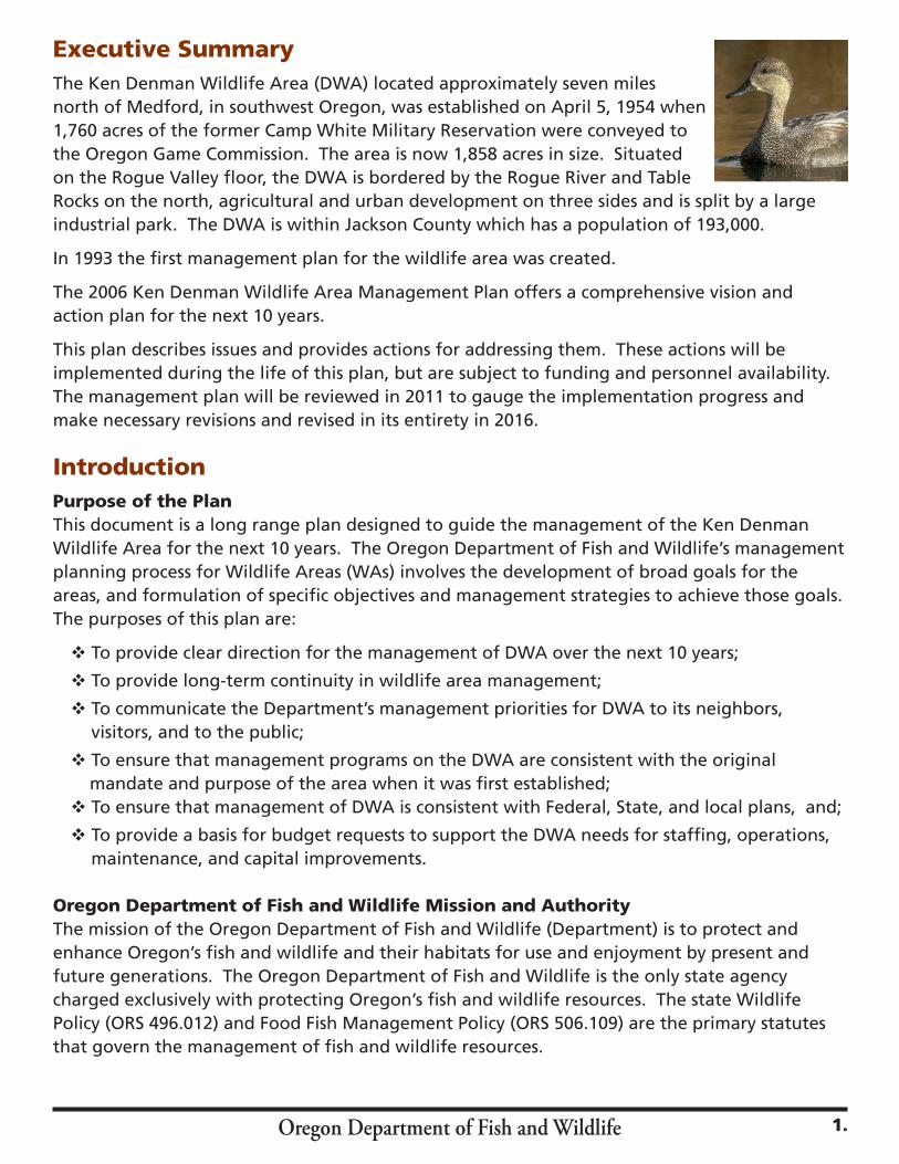
Executive SummaryThe Ken Denman Wildlife Area (DWA) located approximately seven miles north of Medford, in southwest Oregon, was established on April 5, 1954 when 1,760 acres of the former Camp White Military Reservation were conveyed to the Oregon Game Commission. The area is now 1,858 acres in size. Situated on the Rogue Valley floor, the DWA is bordered by the Rogue River and Table Rocks on the north, agricultural and urban development on three sides and is split by a large industrial park. The DWA is within Jackson County which has a population of 193,000.
In 1993 the first management plan for the wildlife area was created.
The 2006 Ken Denman Wildlife Area Management Plan offers a comprehensive vision and action plan for the next 10 years.
This plan describes issues and provides actions for addressing them. These actions will be implemented during the life of this plan, but are subject to funding and personnel availability. The management plan will be reviewed in 2011 to gauge the implementation progress and make necessary revisions and revised in its entirety in 2016.
IntroductionPurpose of the PlanThis document is a long range plan designed to guide the management of the Ken Denman Wildlife Area for the next 10 years. The Oregon Department of Fish and Wildlife’s management planning process for Wildlife Areas (WAs) involves the development of broad goals for the areas, and formulation of specific objectives and management strategies to achieve those goals. The purposes of this plan are:
v To provide clear direction for the management of DWA over the next 10 years;
v To provide long-term continuity in wildlife area management;
v To communicate the Department’s management priorities for DWA to its neighbors, visitors, and to the public;
v To ensure that management programs on the DWA are consistent with the original mandate and purpose of the area when it was first established;
v To ensure that management of DWA is consistent with Federal, State, and local plans, and;
v To provide a basis for budget requests to support the DWA needs for staffing, operations, maintenance, and capital improvements.
Oregon Department of Fish and Wildlife Mission and AuthorityThe mission of the Oregon Department of Fish and Wildlife (Department) is to protect and enhance Oregon’s fish and wildlife and their habitats for use and enjoyment by present and future generations. The Oregon Department of Fish and Wildlife is the only state agency charged exclusively with protecting Oregon’s fish and wildlife resources. The state Wildlife Policy (ORS 496.012) and Food Fish Management Policy (ORS 506.109) are the primary statutes that govern the management of fish and wildlife resources.
1.

Purpose and Need of Ken Denman Wildlife AreaThe Ken Denman Wildlife Area was established in 1954 when 1,760 acres was conveyed to the Oregon Game Commission from the United States General Services Administration via a restrictive deed specifying that the land be used for the purpose of wildlife conservation. Other land acquisitions since that time have increased the size of the area to 1,858 acres.
The wildlife area is currently managed to protect, enhance and restore all fish and wildlife species and their habitats located on the wildlife area, and to provide a wide variety of wildlife-oriented recreational and educational opportunities to the public.
The wildlife area contains many different types of habitats supporting a great diversity of plant and animal species. Important habitats include vernal pools, prairie grasslands, oak woodlands, riparian habitat and wetlands.
A major function of the wildlife area’s management is to provide waterfowl, upland bird and deer hunting opportunities. Fishing, hiking, birding and dog training are some of the other recreational activities offered to the public. The area is also an important resource for outdoor education.
As neighboring land continues to be developed, the open space and wildlife habitat provided on the Denman Wildlife Area will be an increasingly valuable public resource.
Ken Denman Wildlife Area Vision StatementThe vision statement for the Ken Denman Wildlife Area is as follows: Fish and wildlife habitats including grasslands, vernal pools and oak woodlands historically found in the Rogue Valley are clearly visible, biologically healthy and available for the enjoyment of present and future generations.
Wildlife Area Goals and ObjectivesWildlife area goals are broad, open-ended statements of desired future conditions that convey a purpose but do not define measurable units. In contrast, objectives are more concise statements of what the Department wants to achieve, how much the Department wants to achieve, when and where to achieve it, and who will be responsible for the work. Objectives derive from goals and provide the basis for determining strategies, monitoring wildlife area accomplishments, and evaluating the success of strategies. The goals and objectives for the Ken Denman Wildlife Area are:
Goal 1: To protect, enhance and restore habitats to benefit fish and wildlife species.
Objective 1.1: To protect, enhance and restore 286 acres of upland habitats annually to benefit native and desirable non-native wildlife.
Objective 1.2: To protect, enhance and restore 730 acres of wetland, riparian, and freshwater aquatic habitats annually for the benefit of native and desirable non-native fish and wildlife.
Objective 1.3: To protect, enhance and restore 720 acres of vernal pool habitat annually to benefit the native species associated with this unique habitat.
Objective 1.4: Maintain 122 acres of agricultural habitats to provide forage for native and desirable non-native wildlife.
Objective 1.5: To maintain and enhance wildlife area facilities, structures, and equipment to conduct habitat management and public use projects on the wildlife area.
2. Oregon Department of Fish and Wildlife
Oregon Department of Fish and Wildlife
Goal 2: To provide a variety of quality wildlife oriented recreational and educational opportunities to the public which are compatible with Goal 1.
Objective 2.1: To provide approximately 11,300 hunting, trapping, and angling use days annually.
Objective 2.2: To provide approximately 20,000 non-consumptive recreational and education/interpretation use days annually.
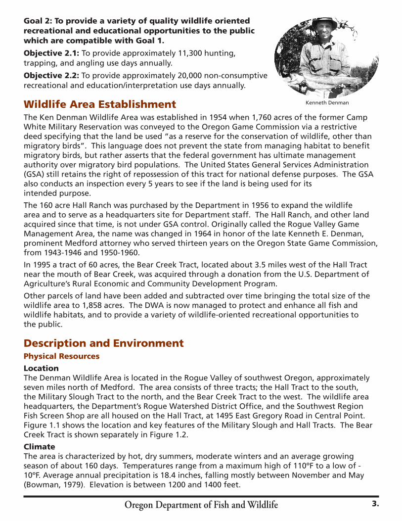
Wildlife Area EstablishmentThe Ken Denman Wildlife Area was established in 1954 when 1,760 acres of the former Camp White Military Reservation was conveyed to the Oregon Game Commission via a restrictive deed specifying that the land be used “as a reserve for the conservation of wildlife, other than migratory birds”. This language does not prevent the state from managing habitat to benefit migratory birds, but rather asserts that the federal government has ultimate management authority over migratory bird populations. The United States General Services Administration (GSA) still retains the right of repossession of this tract for national defense purposes. The GSA also conducts an inspection every 5 years to see if the land is being used for its intended purpose.
The 160 acre Hall Ranch was purchased by the Department in 1956 to expand the wildlife area and to serve as a headquarters site for Department staff. The Hall Ranch, and other land acquired since that time, is not under GSA control. Originally called the Rogue Valley Game Management Area, the name was changed in 1964 in honor of the late Kenneth E. Denman, prominent Medford attorney who served thirteen years on the Oregon State Game Commission, from 1943-1946 and 1950-1960.
In 1995 a tract of 60 acres, the Bear Creek Tract, located about 3.5 miles west of the Hall Tract near the mouth of Bear Creek, was acquired through a donation from the U.S. Department of Agriculture’s Rural Economic and Community Development Program.
Other parcels of land have been added and subtracted over time bringing the total size of the wildlife area to 1,858 acres. The DWA is now managed to protect and enhance all fish and wildlife habitats, and to provide a variety of wildlife-oriented recreational opportunities to the public.
Description and EnvironmentPhysical Resources
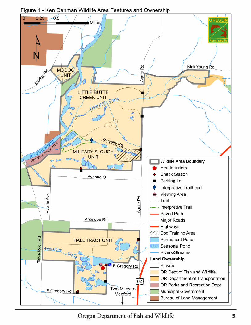
LocationThe Denman Wildlife Area is located in the Rogue Valley of southwest Oregon, approximately seven miles north of Medford. The area consists of three tracts; the Hall Tract to the south, the Military Slough Tract to the north, and the Bear Creek Tract to the west. The wildlife area headquarters, the Department’s Rogue Watershed District Office, and the Southwest Region Fish Screen Shop are all housed on the Hall Tract, at 1495 East Gregory Road in Central Point. Figure 1.1 shows the location and key features of the Military Slough and Hall Tracts. The Bear Creek Tract is shown separately in Figure 1.2.
ClimateThe area is characterized by hot, dry summers, moderate winters and an average growing season of about 160 days. Temperatures range from a maximum high of 110ºF to a low of -10ºF. Average annual precipitation is 18.4 inches, falling mostly between November and May (Bowman, 1979). Elevation is between 1200 and 1400 feet.
Kenneth Denman
3.
Oregon Department of Fish and Wildlife
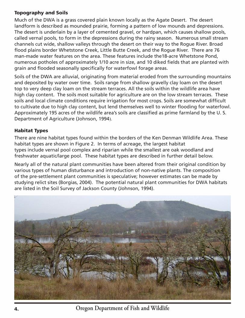
Topography and SoilsMuch of the DWA is a grass covered plain known locally as the Agate Desert. The desert landform is described as mounded prairie, forming a pattern of low mounds and depressions. The desert is underlain by a layer of cemented gravel, or hardpan, which causes shallow pools, called vernal pools, to form in the depressions during the rainy season. Numerous small stream channels cut wide, shallow valleys through the desert on their way to the Rogue River. Broad flood plains border Whetstone Creek, Little Butte Creek, and the Rogue River. There are 76 man-made water features on the area. These features include the18-acre Whetstone Pond, numerous potholes of approximately 1/10 acre in size, and 10 diked fields that are planted with grain and flooded seasonally specifically for waterfowl forage areas.
Soils of the DWA are alluvial, originating from material eroded from the surrounding mountains and deposited by water over time. Soils range from shallow gravelly clay loam on the desert top to very deep clay loam on the stream terraces. All the soils within the wildlife area have high clay content. The soils most suitable for agriculture are on the low stream terraces. These soils and local climate conditions require irrigation for most crops. Soils are somewhat difficult to cultivate due to high clay content, but lend themselves well to winter flooding for waterfowl. Approximately 195 acres of the wildlife area’s soils are classified as prime farmland by the U. S. Department of Agriculture (Johnson, 1994).
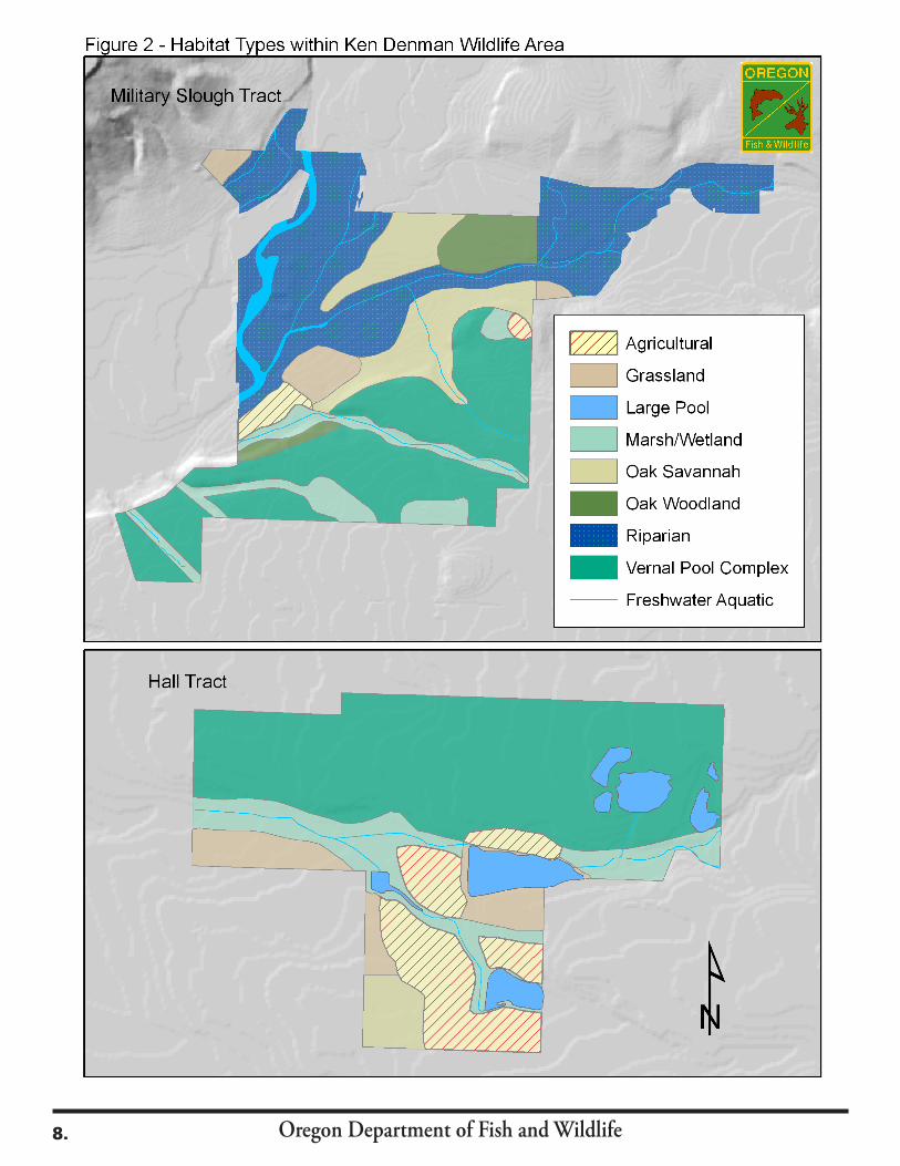
Habitat TypesThere are nine habitat types found within the borders of the Ken Denman Wildlife Area. These habitat types are shown in Figure 2. In terms of acreage, the largest habitattypes include vernal pool complex and riparian while the smallest are oak woodland and freshwater aquatic/large pool. These habitat types are described in further detail below.
Nearly all of the natural plant communities have been altered from their original condition by various types of human disturbance and introduction of non-native plants. The composition of the pre-settlement plant communities is speculative; however estimates can be made by studying relict sites (Borgias, 2004). The potential natural plant communities for DWA habitats are listed in the Soil Survey of Jackson County (Johnson, 1994).
4.
Oregon Department of Fish and Wildlife
62
Nick Young Rd
Mod
oc R
d
Touvelle Rd
Pacific
Ave
Antelope Rd
E Gregory Rd
Table
Rock R
d
Aga
te R
d
E Gregory Rd
Avenue G
Aga
te R
d
Little B
utte Creek
ROG
UE
RIV
ER
MILITARY SLOUGHUNIT
HALL TRACT UNIT
LITTLE BUTTECREEK UNIT
MODOCUNIT
TOUVELLE STATE
PAR
K
Creek
Whetstone
0 0.5 10.25Miles
Two Miles toMedford
62
Wildlife Area Boundary
Headquarters
Check Station
Parking Lot
Interpretive Trailhead
Viewing Area
Trail
Interpretive Trail
Paved Path
Major Roads
Highways
Dog Training Area
Permanent Pond
Seasonal Pond
Rivers/Streams
Land Ownership
Private
OR Dept of Fish and Wildlife
OR Department of Transportation
OR Parks and Recreation Dept
Municipal Government
Bureau of Land Management
Figure 1 - Ken Denman Wildlife Area Features and Ownership
5.

Oregon Department of Fish and Wildlife
Figure 1.2 - Ken Denman Wildlife Area - Bear Creek Tract
Kirtland Rd
Blackwell RdTolo
Rd
Bear C
reek
Upton S
lough
Mid
do
ug
h C
reek
Wildlife Area Boundary
Major Roads
Railroad
Rivers/Streams
Land Ownership
Private
OR Dept of Fish and Wildlife
OR Dept of Transportation
OR Parks and Recreation Dept
Municipal Government
Bureau of Land Management
0 0.1 0.2Miles
0 1 20.5Miles
Military SloughTract
Hall Tract
Bear Creek Tract
Kirtland Rd
Parking Lot
6.
Oregon Department of Fish and Wildlife
Table 1 shows the current habitat types and amount of acres of each type present on the wildlife area. Perennial grasses have been especially affected by past livestock overgrazing and competition from introduced annuals. Native species still exist, but not in their historic range and abundance. Tree and shrub species are nearly all native and have not suffered as much as the native grasses. Fire suppression has had the effect of allowing more mid- to late-seral stage vegetation and a denser understory to occur than would be present under natural conditions.
Table 1. Habitat Types and Approximate Acreages on the Ken Denman Wildlife Area.
Habitat Type Acres
Vernal Pool Complex 720
Riparian 500
Marsh/Wetland 200
Oak Savannah 150
Agricultural 122
Grassland 66
Oak Woodland 70
Freshwater Aquatic/Large Pool 30
Total 1,858
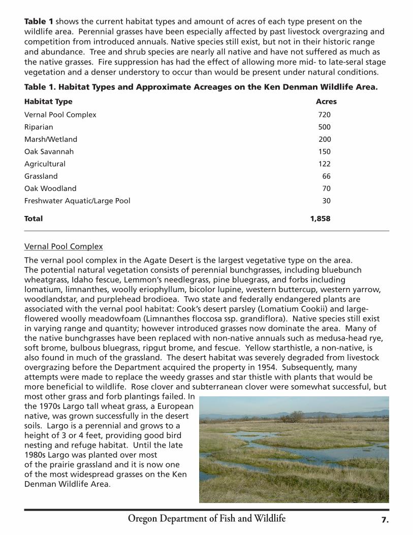
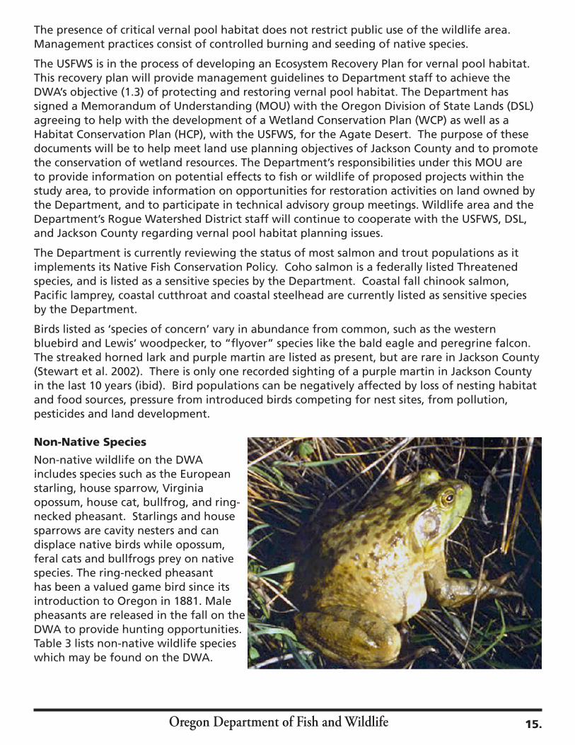
Vernal Pool Complex
The vernal pool complex in the Agate Desert is the largest vegetative type on the area. The potential natural vegetation consists of perennial bunchgrasses, including bluebunch wheatgrass, Idaho fescue, Lemmon’s needlegrass, pine bluegrass, and forbs including lomatium, limnanthes, woolly eriophyllum, bicolor lupine, western buttercup, western yarrow, woodlandstar, and purplehead brodioea. Two state and federally endangered plants are associated with the vernal pool habitat: Cook’s desert parsley (Lomatium Cookii) and large-flowered woolly meadowfoam (Limnanthes floccosa ssp. grandiflora). Native species still exist in varying range and quantity; however introduced grasses now dominate the area. Many of the native bunchgrasses have been replaced with non-native annuals such as medusa-head rye, soft brome, bulbous bluegrass, ripgut brome, and fescue. Yellow starthistle, a non-native, is also found in much of the grassland. The desert habitat was severely degraded from livestock overgrazing before the Department acquired the property in 1954. Subsequently, many attempts were made to replace the weedy grasses and star thistle with plants that would be more beneficial to wildlife. Rose clover and subterranean clover were somewhat successful, but most other grass and forb plantings failed. In the 1970s Largo tall wheat grass, a European native, was grown successfully in the desert soils. Largo is a perennial and grows to a height of 3 or 4 feet, providing good bird nesting and refuge habitat. Until the late 1980s Largo was planted over most of the prairie grassland and it is now one of the most widespread grasses on the Ken Denman Wildlife Area.
7.
Oregon Department of Fish and Wildlife8.

Oregon Department of Fish and Wildlife
Riparian Habitat
Riparian areas border the water features on the DWA. The potential riparian plant community consists of white alder (Alnus rhombifolia), black cottonwood (Populus trichocarpa), bigleaf maple (Acer macrophyllum), and willow (Salix spp.), with an understory of wild grape, oceanspray, and mockorange. Reed canarygrass, Himalayan blackberry and poison hemlock, introduced invasives from Europe, are also found in the riparian understory.
Marsh/Wetlands
Wetlands are located primarily along Whetstone Creek and Military Slough. Historically these streams went dry in the summer but are now fed by irrigation water, keeping the marshs wet year round. Marsh lands are typically dominated by cattails, rushes, sedges and grasses, with some scattered willow and Oregon ash. Non-native reed canary grass, however, has invaded much of the marsh, displacing the rushes and sedges. Other non-natives such as common teasel, Himalayan blackberry, and poison hemlock, are also present. Ponds and wetlands are used by a wide variety of wildlife species, including waterfowl, herons, shorebirds, perching birds, amphibians, reptiles and furbearers. Wetlands also contribute to improved downstream water quality. The wetlands on the wildlife area are important recreational and educational attractions to the public.
Oak Savannah
Oak savannah is found on drier sites on the area, between the desert plateau and low stream terraces. The potential natural vegetation of oak savannah consists of Oregon white oak (Quercus garryana) and grasses which include Idaho fescue, bluebunch wheatgrass, blue wildrye, and junegrass. Non-native grasses such as Largo, bulbous bluegrass, and annual fescue now grow along with the natives. Historically, frequent low-intensity fires probably maintained the vigor and nutrition of native grasses and created wider spacing between oaks than is found today. Himalayan blackberry (Rubus discolor) has also invaded portions of the oak savannah.
Agricultural
Approximately 122 acres of converted grasslands is classified as agricultural land, but the majority of this acreage has not been farmed since 1990 when DWA staff was reduced. Much of this acreage has reverted back to non-native grassland. About 40 acres is now planted annually in grain crops for wildlife use and another 10 acres, consisting mostly of timothy, is in irrigated grassland. Ten fields, totaling 30 acres, are planted with grain for waterfowl use and 6 fields totaling 10 acres are planted for upland bird use. Because barley can be planted without irrigation, it is the primary crop grown for waterfowl. Some irrigated crops such as Sudan grass, sorghum and millet are also grown. Crops planted for upland bird forage include corn, millet, sunflowers, wheat, peas, and clover.
Grassland
Grasslands are found on deeper soils along the stream terraces. Native vegetation probably consisted of Lemmon’s needlegrass, California fescue, bluebunch wheatgrass, and junegrass. This habitat is now dominated by non-natives such as timothy, largo tall wheatgrass, tall fescue, soft brome, bulbous bluegrass, and rye grass.
9.
Oregon Department of Fish and Wildlife
Oak Woodland
Oak woodlands occupy moist sites on the terraces along the Rogue River and Little Butte Creek. Tree species are predominantly California black oak (Quercus kellogii) and Oregon ash (Fraxinus latifolia), with an understory of poison-oak (Rhus diversiloba), mockorange (Philadelphus lewisii), wild rose (Rosa ssp.), snowberry (Symphoricarpos albus) and willow (Salix spp.). A few conifers, Douglas-fir (Pseudotsuga menziesii) and ponderosa pine (Pinus ponderosa), are intermixed. Small open grasslands are interspersed throughout the woodland habitat, with significant portions infested with Himalayan blackberry.
Freshwater Aquatic/Large Pool
This habitat type includes rivers and streams such as the Rogue River and Little Butte Creek and open water such as Whetstone Pond and other large bodies of water.
Description of TractsThe Ken Denman Wildlife Area consists of three tracts; the Hall Tract and the Military Slough, acquired in the 1950s, and the Bear Creek Tract, acquired in 1995. The Hall Tract to the south comprises 600 acres, the Military Slough Tract to the north is 1,198 acres, and the Bear Creek Tract to the west is 60 acres. The Military Slough Tract is further divided into three units roughly equal in size; the Military Slough Unit, the Little Butte Creek Unit, and the Modoc Unit.
Hall Tract
The Hall Tract (Figure 2) is 600 acres in size, and is roughly divided by Whetstone Creek with the Agate Desert to the north and agricultural fields, oak woodland and grassland to the south. Elevation ranges from 1,200 to 1,400 feet. Most of the irrigated farm land found on the DWA is located on this tract. The land is flood irrigated through a system of reservoirs and ditches. Eight diked fields totaling 24 acres are planted in grain crops annually and flooded for waterfowl. An additional 10 acres are planted in grain for upland birds, and 10 acres is in irrigated grass. The Hall Tract has numerous artificially created reservoirs and ponds, consisting of: 4 irrigation reservoirs with headgates, 4 small permanent ponds, and 44 small (1/10-1/2-acre) seasonal ponds, many with nest islands for waterfowl.
The main soil types are Cove clay and Padigan clay, both very deep poorly drained soils. High clay content makes these soils difficult to cultivate but reasonably productive. The Agate Desert section of the Hall Tract is a broad elevated terrace sloping gently down to Whetstone Creek. The soil type is Agate-Winlow complex in the form of mounded prairie, composed of Agate soil on the mounds and Winlow soil in the depressions, and soils are shallow over a layer of hardpan. Land management decisions are limited by this soil composition because of characteristics such as wetness in winter and spring, shallow depth to hardpan, high compaction, and the very gravelly surface layer of Winlow soil. Controlled burning and seeding with native plants is now the recommended method of improving the condition of this habitat (Johnson, 1994). Past management practices by DWA staff involved attempts to improve this soil for agriculture by sub-surface ripping of the hardpan and filling the vernal pools with bark mulch from local lumber mills. This practice was stopped in the late 1980s when the value of the natural vernal pool habitat and its flora and fauna was realized.
Military Slough Tract
The Military Slough Tract (Figure 2) consists of 1,198 acres and is located about 1 mile north of the Hall Tract. Elevation ranges from 1,200 to 1,400 feet. Three Class 1 streams, the Rogue River,
10.
Oregon Department of Fish and Wildlife
Little Butte Creek and Military Slough, pass through this tract. The confluence of Little Butte Creek and the Rogue is near the west center of the tract. This tract also has numerous artificial ponds and wetlands, including 3 permanent ponds with headgates, 10 small permanent ponds, and 14 seasonal ponds. Two 3-acre diked fields are planted with grain and flooded for waterfowl use. During the 1964 flood, the Rogue River changed course, moving about 1000 feet west, then rejoined the old channel just downstream of the mouth of Little Butte Creek. The old channel still carries some water but is more of a slough. The area between the old and new channels is referred to as the “island”. The Agate Desert is the major landform in the south half of the tract, gently sloping on top, then dropping sharply down to the Rogue River floodplain. The thirteen ammunition bunkers remaining from Camp White are dug into the bottom of this slope. Soils on the desert top are shallow and underlain with hardpan, while soils on the floodplain are deep clay loam. The north half of the tract is floodplain, covered with oak woodland and riparian vegetation. Some of the most fertile soils on the DWA, Medford Clay Loam and Medford Silty Clay Loam, are located under the oak woodland (Johnson, 1994).
Bear Creek Tract
The Bear Creek Tract is 60 acres in size and is located 3.5 miles west of the Military Slough. This tract is bisected by Bear Creek and is a nearly level stream terrace. The vegetation consists of riparian habitat along the stream channel shifting to open farmland. The tract is bordered by private farmland and by Kirtland Road. Soils are deep silty clay loam. Thirteen acres within this tract are classified as prime farmland (Johnson, 1994). Before the property was acquired by the Department it was farmed with winter wheat. This tract is currently farmed by the adjacent property owner with wheat and alfalfa, with the agreement that a 15 foot edge is left un-harvested around the perimeter. It is not actively managed by DWA staff.
Biological ResourcesThe DWA provides valuable habitat for a diversity of wildlife species, in part because of its proximity to the Rogue River and in part because of the loss of natural habitats in the surrounding area. Currently 237 species of wildlife have been identified on the DWA, including 175 species of birds, 41 species of mammals, and 21 species of amphibians and reptiles (Collins, 1992). See Appendix C for a list of species.
Birds
The DWA has a wide variety of bird species using the many habitats available throughout the Area. Tree cavities, shrub thickets, grasslands and riparian areas are used for nesting. Abundant grain, weed seeds, berries, acorns, insects, water and cover provide favorable conditions for resident, migrating and wintering birds.
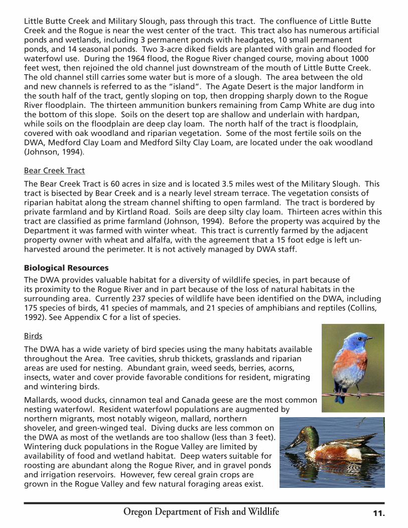
Mallards, wood ducks, cinnamon teal and Canada geese are the most common nesting waterfowl. Resident waterfowl populations are augmented by northern migrants, most notably wigeon, mallard, northern shoveler, and green-winged teal. Diving ducks are less common on the DWA as most of the wetlands are too shallow (less than 3 feet). Wintering duck populations in the Rogue Valley are limited by availability of food and wetland habitat. Deep waters suitable for roosting are abundant along the Rogue River, and in gravel ponds and irrigation reservoirs. However, few cereal grain crops are grown in the Rogue Valley and few natural foraging areas exist.
11.
Oregon Department of Fish and Wildlife
Mourning doves have shown good breeding and migrant populations but these numbers have declined from historic levels. This reduction is attributed to many factors including development of adjacent open land, reduced grain production, competition from introduced species, and pesticides. California quail are found in good numbers along the river bottoms.
There is a small breeding population of ring-necked pheasants, but loss of habitat on surrounding property and pressure from predators such as house cats limit the population. Pheasant populations on the DWA are also limited by lack of adequate winter forage and cover. Pen-raised rooster pheasants are released by the Department each fall for the Youth Pheasant Hunt and the Fee Pheasant Hunt.
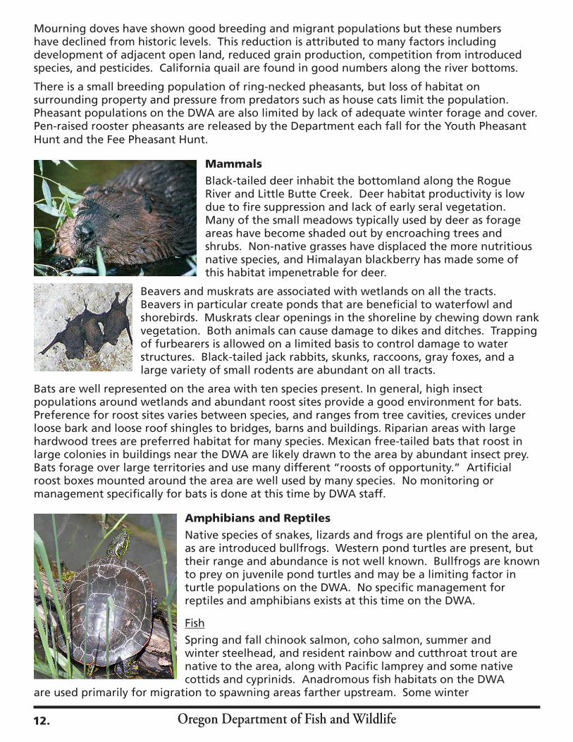
MammalsBlack-tailed deer inhabit the bottomland along the Rogue River and Little Butte Creek. Deer habitat productivity is low due to fire suppression and lack of early seral vegetation. Many of the small meadows typically used by deer as forage areas have become shaded out by encroaching trees and shrubs. Non-native grasses have displaced the more nutritious native species, and Himalayan blackberry has made some of this habitat impenetrable for deer.
Beavers and muskrats are associated with wetlands on all the tracts. Beavers in particular create ponds that are beneficial to waterfowl and shorebirds. Muskrats clear openings in the shoreline by chewing down rank vegetation. Both animals can cause damage to dikes and ditches. Trapping of furbearers is allowed on a limited basis to control damage to water structures. Black-tailed jack rabbits, skunks, raccoons, gray foxes, and a large variety of small rodents are abundant on all tracts.
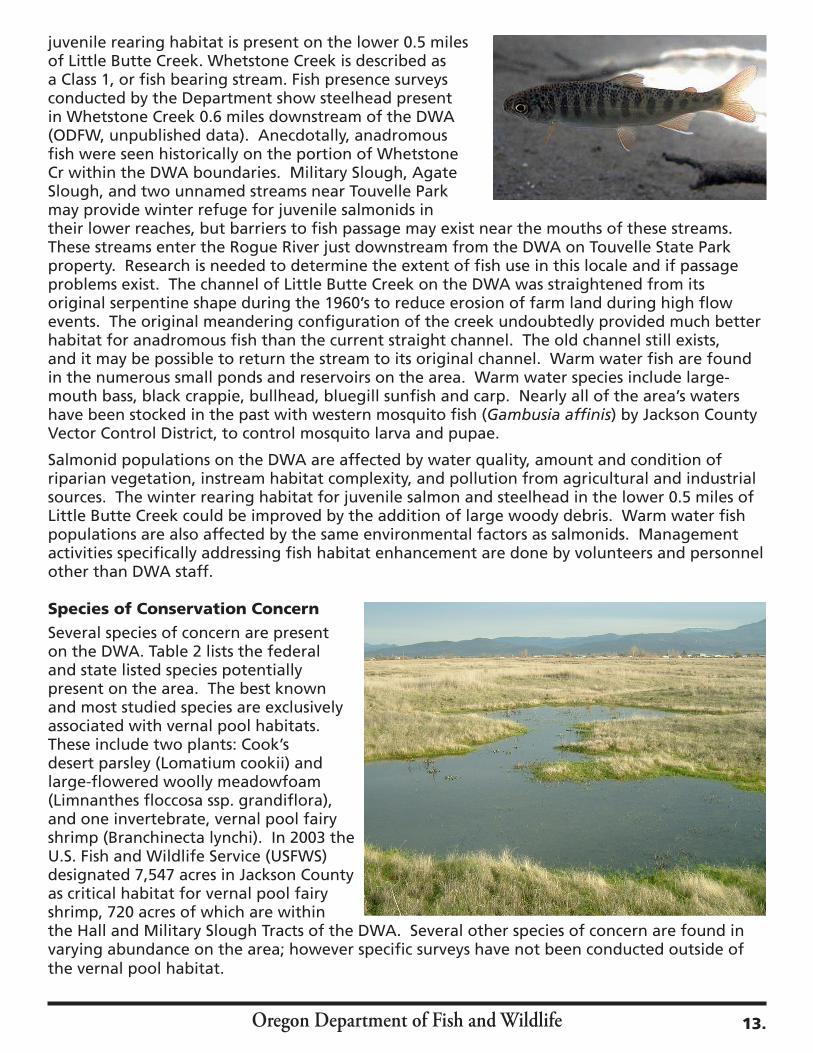
Bats are well represented on the area with ten species present. In general, high insect populations around wetlands and abundant roost sites provide a good environment for bats. Preference for roost sites varies between species, and ranges from tree cavities, crevices under loose bark and loose roof shingles to bridges, barns and buildings. Riparian areas with large hardwood trees are preferred habitat for many species. Mexican free-tailed bats that roost in large colonies in buildings near the DWA are likely drawn to the area by abundant insect prey. Bats forage over large territories and use many different “roosts of opportunity.” Artificial roost boxes mounted around the area are well used by many species. No monitoring or management specifically for bats is done at this time by DWA staff.
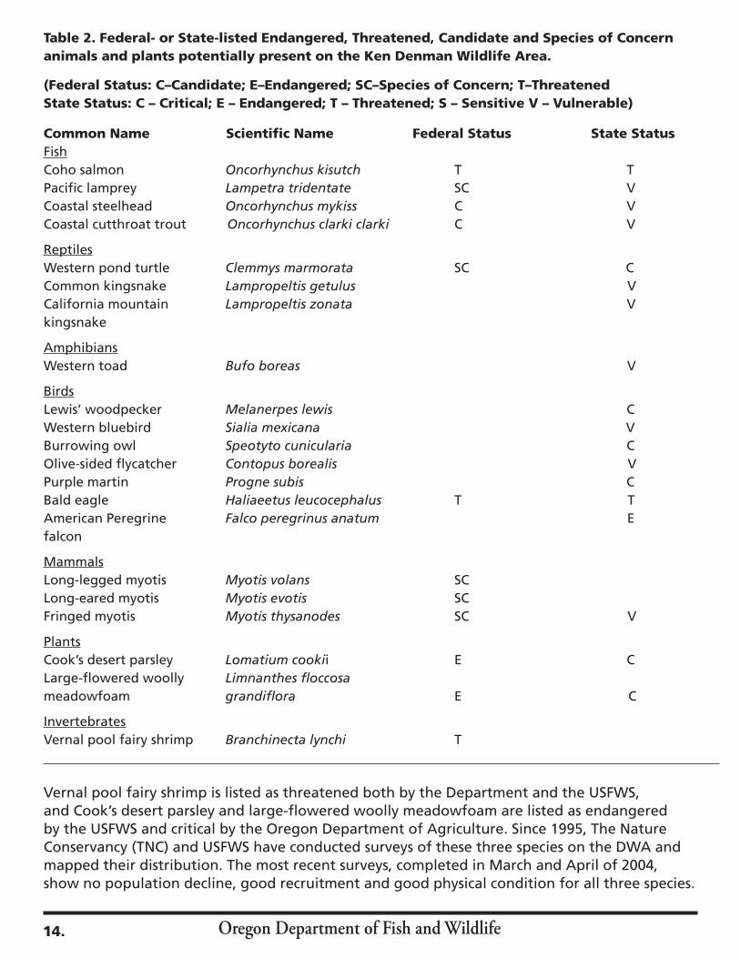
Amphibians and ReptilesNative species of snakes, lizards and frogs are plentiful on the area, as are introduced bullfrogs. Western pond turtles are present, but their range and abundance is not well known. Bullfrogs are known to prey on juvenile pond turtles and may be a limiting factor in turtle populations on the DWA. No specific management for reptiles and amphibians exists at this time on the DWA.
Fish
Spring and fall chinook salmon, coho salmon, summer and winter steelhead, and resident rainbow and cutthroat trout are native to the area, along with Pacific lamprey and some native cottids and cyprinids. Anadromous fish habitats on the DWA
are used primarily for migration to spawning areas farther upstream. Some winter
12.
Oregon Department of Fish and Wildlife
juvenile rearing habitat is present on the lower 0.5 miles of Little Butte Creek. Whetstone Creek is described as a Class 1, or fish bearing stream. Fish presence surveys conducted by the Department show steelhead present in Whetstone Creek 0.6 miles downstream of the DWA (ODFW, unpublished data). Anecdotally, anadromous fish were seen historically on the portion of Whetstone Cr within the DWA boundaries. Military Slough, Agate Slough, and two unnamed streams near Touvelle Park may provide winter refuge for juvenile salmonids in their lower reaches, but barriers to fish passage may exist near the mouths of these streams. These streams enter the Rogue River just downstream from the DWA on Touvelle State Park property. Research is needed to determine the extent of fish use in this locale and if passage problems exist. The channel of Little Butte Creek on the DWA was straightened from its original serpentine shape during the 1960’s to reduce erosion of farm land during high flow events. The original meandering configuration of the creek undoubtedly provided much better habitat for anadromous fish than the current straight channel. The old channel still exists, and it may be possible to return the stream to its original channel. Warm water fish are found in the numerous small ponds and reservoirs on the area. Warm water species include large-mouth bass, black crappie, bullhead, bluegill sunfish and carp. Nearly all of the area’s waters have been stocked in the past with western mosquito fish (Gambusia affinis) by Jackson County Vector Control District, to control mosquito larva and pupae.
Salmonid populations on the DWA are affected by water quality, amount and condition of riparian vegetation, instream habitat complexity, and pollution from agricultural and industrial sources. The winter rearing habitat for juvenile salmon and steelhead in the lower 0.5 miles of Little Butte Creek could be improved by the addition of large woody debris. Warm water fish populations are also affected by the same environmental factors as salmonids. Management activities specifically addressing fish habitat enhancement are done by volunteers and personnel other than DWA staff. Species of Conservation ConcernSeveral species of concern are present on the DWA. Table 2 lists the federal and state listed species potentially present on the area. The best known and most studied species are exclusively associated with vernal pool habitats. These include two plants: Cook’s desert parsley (Lomatium cookii) and large-flowered woolly meadowfoam (Limnanthes floccosa ssp. grandiflora), and one invertebrate, vernal pool fairy shrimp (Branchinecta lynchi). In 2003 the U.S. Fish and Wildlife Service (USFWS) designated 7,547 acres in Jackson County as critical habitat for vernal pool fairy shrimp, 720 acres of which are within the Hall and Military Slough Tracts of the DWA. Several other species of concern are found in varying abundance on the area; however specific surveys have not been conducted outside of the vernal pool habitat.
13.
Oregon Department of Fish and Wildlife
Table 2. Federal- or State-listed Endangered, Threatened, Candidate and Species of Concern animals and plants potentially present on the Ken Denman Wildlife Area.
(Federal Status: C–Candidate; E–Endangered; SC–Species of Concern; T–ThreatenedState Status: C – Critical; E – Endangered; T – Threatened; S – Sensitive V – Vulnerable)
Common Name Scientific Name Federal Status State StatusFishCoho salmon Oncorhynchus kisutch T TPacific lamprey Lampetra tridentate SC VCoastal steelhead Oncorhynchus mykiss C VCoastal cutthroat trout Oncorhynchus clarki clarki C V ReptilesWestern pond turtle Clemmys marmorata SC CCommon kingsnake Lampropeltis getulus V California mountain Lampropeltis zonata Vkingsnake AmphibiansWestern toad Bufo boreas V
BirdsLewis’ woodpecker Melanerpes lewis CWestern bluebird Sialia mexicana VBurrowing owl Speotyto cunicularia COlive-sided flycatcher Contopus borealis VPurple martin Progne subis CBald eagle Haliaeetus leucocephalus T TAmerican Peregrine Falco peregrinus anatum Efalcon
MammalsLong-legged myotis Myotis volans SCLong-eared myotis Myotis evotis SCFringed myotis Myotis thysanodes SC V
PlantsCook’s desert parsley Lomatium cookii E CLarge-flowered woolly Limnanthes floccosameadowfoam grandiflora E C
InvertebratesVernal pool fairy shrimp Branchinecta lynchi T
Vernal pool fairy shrimp is listed as threatened both by the Department and the USFWS, and Cook’s desert parsley and large-flowered woolly meadowfoam are listed as endangered by the USFWS and critical by the Oregon Department of Agriculture. Since 1995, The Nature Conservancy (TNC) and USFWS have conducted surveys of these three species on the DWA and mapped their distribution. The most recent surveys, completed in March and April of 2004, show no population decline, good recruitment and good physical condition for all three species.
14.
Oregon Department of Fish and Wildlife
The presence of critical vernal pool habitat does not restrict public use of the wildlife area. Management practices consist of controlled burning and seeding of native species.
The USFWS is in the process of developing an Ecosystem Recovery Plan for vernal pool habitat. This recovery plan will provide management guidelines to Department staff to achieve the DWA’s objective (1.3) of protecting and restoring vernal pool habitat. The Department has signed a Memorandum of Understanding (MOU) with the Oregon Division of State Lands (DSL) agreeing to help with the development of a Wetland Conservation Plan (WCP) as well as a Habitat Conservation Plan (HCP), with the USFWS, for the Agate Desert. The purpose of these documents will be to help meet land use planning objectives of Jackson County and to promote the conservation of wetland resources. The Department’s responsibilities under this MOU are to provide information on potential effects to fish or wildlife of proposed projects within the study area, to provide information on opportunities for restoration activities on land owned by the Department, and to participate in technical advisory group meetings. Wildlife area and the Department’s Rogue Watershed District staff will continue to cooperate with the USFWS, DSL, and Jackson County regarding vernal pool habitat planning issues.
The Department is currently reviewing the status of most salmon and trout populations as it implements its Native Fish Conservation Policy. Coho salmon is a federally listed Threatened species, and is listed as a sensitive species by the Department. Coastal fall chinook salmon, Pacific lamprey, coastal cutthroat and coastal steelhead are currently listed as sensitive species by the Department.
Birds listed as ‘species of concern’ vary in abundance from common, such as the western bluebird and Lewis’ woodpecker, to “flyover” species like the bald eagle and peregrine falcon. The streaked horned lark and purple martin are listed as present, but are rare in Jackson County (Stewart et al. 2002). There is only one recorded sighting of a purple martin in Jackson County in the last 10 years (ibid). Bird populations can be negatively affected by loss of nesting habitat and food sources, pressure from introduced birds competing for nest sites, from pollution, pesticides and land development.
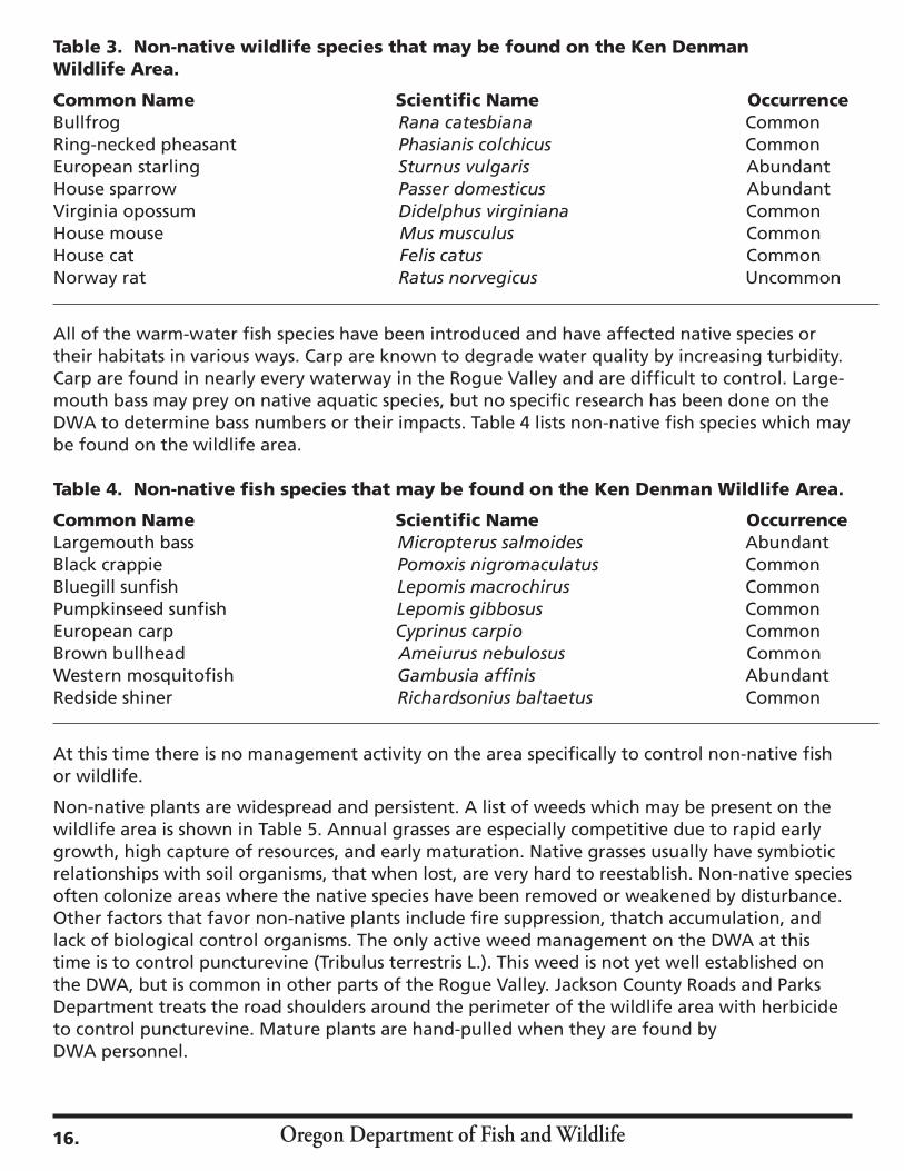
Non-Native Species Non-native wildlife on the DWA includes species such as the European starling, house sparrow, Virginia opossum, house cat, bullfrog, and ring-necked pheasant. Starlings and house sparrows are cavity nesters and can displace native birds while opossum, feral cats and bullfrogs prey on native species. The ring-necked pheasant has been a valued game bird since its introduction to Oregon in 1881. Male pheasants are released in the fall on the DWA to provide hunting opportunities. Table 3 lists non-native wildlife species which may be found on the DWA.
15.
Oregon Department of Fish and Wildlife
Table 3. Non-native wildlife species that may be found on the Ken Denman Wildlife Area.
Common Name Scientific Name OccurrenceBullfrog Rana catesbiana CommonRing-necked pheasant Phasianis colchicus CommonEuropean starling Sturnus vulgaris AbundantHouse sparrow Passer domesticus Abundant Virginia opossum Didelphus virginiana Common House mouse Mus musculus Common House cat Felis catus CommonNorway rat Ratus norvegicus Uncommon
All of the warm-water fish species have been introduced and have affected native species or their habitats in various ways. Carp are known to degrade water quality by increasing turbidity. Carp are found in nearly every waterway in the Rogue Valley and are difficult to control. Large-mouth bass may prey on native aquatic species, but no specific research has been done on the DWA to determine bass numbers or their impacts. Table 4 lists non-native fish species which may be found on the wildlife area.
Table 4. Non-native fish species that may be found on the Ken Denman Wildlife Area.
Common Name Scientific Name OccurrenceLargemouth bass Micropterus salmoides AbundantBlack crappie Pomoxis nigromaculatus CommonBluegill sunfish Lepomis macrochirus CommonPumpkinseed sunfish Lepomis gibbosus CommonEuropean carp Cyprinus carpio CommonBrown bullhead Ameiurus nebulosus CommonWestern mosquitofish Gambusia affinis AbundantRedside shiner Richardsonius baltaetus Common
At this time there is no management activity on the area specifically to control non-native fish or wildlife.
Non-native plants are widespread and persistent. A list of weeds which may be present on the wildlife area is shown in Table 5. Annual grasses are especially competitive due to rapid early growth, high capture of resources, and early maturation. Native grasses usually have symbiotic relationships with soil organisms, that when lost, are very hard to reestablish. Non-native species often colonize areas where the native species have been removed or weakened by disturbance. Other factors that favor non-native plants include fire suppression, thatch accumulation, and lack of biological control organisms. The only active weed management on the DWA at this time is to control puncturevine (Tribulus terrestris L.). This weed is not yet well established on the DWA, but is common in other parts of the Rogue Valley. Jackson County Roads and Parks Department treats the road shoulders around the perimeter of the wildlife area with herbicide to control puncturevine. Mature plants are hand-pulled when they are found by DWA personnel.
16.
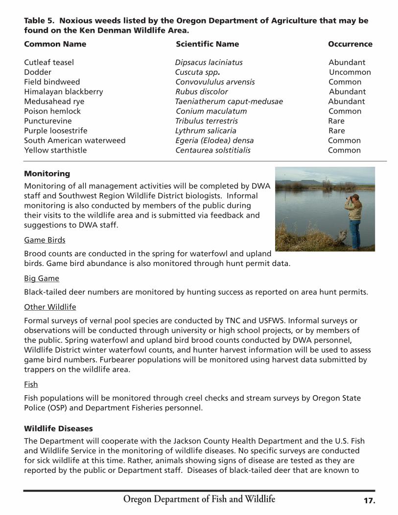
Table 5. Noxious weeds listed by the Oregon Department of Agriculture that may be found on the Ken Denman Wildlife Area. Common Name Scientific Name Occurrence
Cutleaf teasel Dipsacus laciniatus AbundantDodder Cuscuta spp. UncommonField bindweed Convovululus arvensis CommonHimalayan blackberry Rubus discolor AbundantMedusahead rye Taeniatherum caput-medusae AbundantPoison hemlock Conium maculatum CommonPuncturevine Tribulus terrestris RarePurple loosestrife Lythrum salicaria RareSouth American waterweed Egeria (Elodea) densa CommonYellow starthistle Centaurea solstitialis Common
Monitoring
Monitoring of all management activities will be completed by DWA staff and Southwest Region Wildlife District biologists. Informal monitoring is also conducted by members of the public during their visits to the wildlife area and is submitted via feedback and suggestions to DWA staff.
Game Birds
Brood counts are conducted in the spring for waterfowl and upland birds. Game bird abundance is also monitored through hunt permit data.
Big Game
Black-tailed deer numbers are monitored by hunting success as reported on area hunt permits.
Other Wildlife
Formal surveys of vernal pool species are conducted by TNC and USFWS. Informal surveys or observations will be conducted through university or high school projects, or by members of the public. Spring waterfowl and upland bird brood counts conducted by DWA personnel, Wildlife District winter waterfowl counts, and hunter harvest information will be used to assess game bird numbers. Furbearer populations will be monitored using harvest data submitted by trappers on the wildlife area.
Fish
Fish populations will be monitored through creel checks and stream surveys by Oregon State Police (OSP) and Department Fisheries personnel.
Wildlife Diseases The Department will cooperate with the Jackson County Health Department and the U.S. Fish and Wildlife Service in the monitoring of wildlife diseases. No specific surveys are conducted for sick wildlife at this time. Rather, animals showing signs of disease are tested as they are reported by the public or Department staff. Diseases of black-tailed deer that are known to
Oregon Department of Fish and Wildlife 17.

Oregon Department of Fish and Wildlife
occur in southwest Oregon such as adenovirus hemorrhagic disease and hair loss syndrome are not transmissible to humans or livestock and have no known cure. Chronic Wasting Disease (CWD) has not been detected in Oregon, but deer exhibiting any signs of illness will be tested. There are many types of disease that could potentially affect birds on the DWA, but occurrence of disease is low. All diseased birds reported by hunters or DWA personnel will be tested.
Vector Control The Department will cooperate with and assist the Jackson County Vector Control District (JCVCD) in their efforts to manage mosquito populations on the DWA. Presently, JCVCD’s activities on the area consist of placing and monitoring a sentinel flock of ten chickens, monitoring five adult mosquito traps, and sampling wetlands for abundance and species of mosquito larvae. Western mosquito fish (Gambusia affinis) are no longer stocked by JCVC but are still present in most waters on the area. Adult mosquitoes are tested for presence of West Nile Virus (WNV), Western Equine Encephalitis (WEE), and St. Louis Encephalitis (SLE). West Nile Virus was detected in mosquitoes and in sentinel chickens on the DWA in 2005. DWA personnel will assist JCVCD in accessing the DWA to conduct sampling. JCVCD will be permitted to use chemical control in the form of the larvicide Bacillus thuringiensis israelensis if it is determined that mosquitoes on the DWA constitute a significant threat to public health.
Water Use
Irrigation water use by the Denman Wildlife Area will be reported annually to the Oregon Department of Water Resources and the Rogue River Valley Irrigation District.
Public Use
Hunter use can be determined using check station data, and individual check in and check out is required during the Youth Pheasant Hunt. Use of the Touvelle and Modoc Road gates is recorded by the number of keys issued to the public (presently over 5000 keys). Participation is recorded during special events such as Youth Angling Enhancement Day, during guided school field trips and scouting events.
Cultural Resources
Before European settlement the land which is now the Ken Denman Wildlife Area was part of the territory of the Upland Takelma tribe of Native Americans (Hopkins, 1978). These people subsisted on fish, acorns, camas root, grass seed and other native foods from the rivers, hills and meadows of the Rogue Valley. Many of the events recounted during the Rogue River Wars of the 1850s occurred in and around the DWA. The Rogue Valley was sparsely settled by Europeans until the discovery of gold near Jacksonville in 1852. This brought a great influx of
18.
Oregon Department of Fish and Wildlife
miners and settlers to the area, and resulted in increased conflicts with the Native Americans. The Army was called in to keep order and Fort Lane was built on the banks of the Rogue River a few miles downstream from the present site of the DWA. The Army attempted to confine the Native Americans to a reservation between the Table Rocks and Evans Creek, but problems could not be resolved peacefully, and in the spring of 1856 all Native Americans in the upper Rogue Valley were moved to the combined tribal reservation at Siletz, on the Oregon Coast (Beckham, 2002).
By 1883, Central Point had been settled by Europeans (Tucker, 1931). Farming of grain crops and hay, livestock ranching and fruit orchards, particularly pears, were the first commercial activities. Wood products later gained in importance and remain so today. Much of the land to the north and east of Central Point was a dry grass-covered plain that was used for grazing livestock. V.D. Brophy, local rancher, owned a major portion of the Agate Desert grazing land, prior to federal government acquisition of the land in 1942. By Brophy’s account, the spring of 1920 was favorable for plant growth and grass stood “stirrup high” on the desert. However, he stated that he hadn’t seen the desert in that condition since that time and that the majority of the desert had been overgrazed and become infested with foxtail and other undesirable annuals (Oregon Game Commission, 1949).
With the United States’ entry into World War II in 1941, the Army chose the lightly populated and relatively flat Agate Desert to build a training facility. Camp White was constructed in just over six months in 1942, and at its height encompassed 77 square miles, contained 1,300 buildings, and had a population of 40,000 military and civilian support personnel (Kramer,1992). When the war ended in 1945, Camp White was decommissioned and the land and structures were gradually transferred to other ownership. Buildings were moved to other locations in the Rogue Valley and were converted to schools, industrial buildings and residences, many of which are still in use today. The land was returned to private hands or transferred to the State of Oregon. The land that is now the Denman Wildlife Area was transferred to the Oregon Game Commission on April 5, 1954. The only structures remaining from Camp White on the wildlife area are thirteen underground ammunition bunkers that are currently used for equipment storage.
The Department is responsible for coordinating with the State Historic Preservation Office (SHPO) on an annual basis to ensure that proposed area management activities comply with State and Federal cultural resource laws. No comprehensive cultural resource surveys have been conducted on the area, and at this time aside from the underground bunkers, no other significant cultural resources are known to exist on the wildlife area.
Social EnvironmentDemographics
The DWA is located near the city of Medford in Jackson County, one of the most rapidly growing areas in Oregon. Census figures indicate approximately 68% of the county’s 193,000 residents live within 20 miles of Medford. The DWA contains some of the last natural habitats remaining on the floor of the Rogue Valley such as rare and unique vernal pool habitat, oak woodlands and prairie grassland. As natural habitats and open space become less available due to urban growth, the DWA will become an increasingly valuable public resource.
19.
Oregon Department of Fish and Wildlife20.

Oregon Department of Fish and Wildlife
Vandalism and illegal dumping of trash are an ongoing problem on the area. Public road access, increased dumping fees at local landfills and the proximity to a large urban center perpetuate this misuse. This problem requires constant attention by DWA staff, directing volunteers who spend approximately 30 hours per month cleaning up litter.
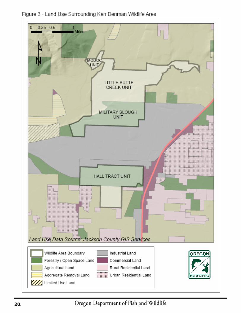
Land UseThe Ken Denman Wildlife Area is surrounded by numerous land uses, ranging from agriculture and residential to industrial. Figure 3 shows the land uses which border the area. The wildlife area is essentially split in two by industrially zoned lands. The southern Hall tract is bordered by agricultural, industrial and residential land uses.
InfrastructureDevelopments/FacilitiesThe DWA headquarters is located within the Department’s Rogue Watershed District Office, at 1495 East Gregory Road, in Central Point. This office building contains a conference room, a reception area, a wildlife maintenance shop and office space for fourteen Department staff. The site also houses the Southwest Region Fish Screens Shop.
In addition to the Rogue Watershed District Office itself, other structures on the area include: v a 3000 square foot barn and equipment storage building, v a 750 square foot wood shop, v a 1,750 square foot metal equipment shed, v a second 600 square foot storage building, v a 38,400 square foot pheasant pen, v a 180 square foot, covered viewing platform, located on the south shore of Whetstone Pond v six hunter check stations, v eight parking lots at established access points, and; v a RV Camp Host site, with utilities.
There are 14 miles of fences and 22 miles of trails that need to be continually maintained. The hunter check stations also require maintenance and, during hunting season, frequent stocking of permits and informational material.
Water RightsTwo types of water rights exist on the DWA; those rights that are owned by the Department, and those that are owned and administered by Rogue River Valley Irrigation District (RRVID). There are ten state water rights that are owned by the Department and 106 acres of assessed certified water rights for which a yearly fee is paid to RRVID. Appendix D shows State and irrigation district water rights which are currently held on the Ken Denman Wildlife Area.
Easements/Access AgreementsThe majority of the easements and access agreements on the DWA are for maintenance of power lines crossing the area. Others are for shared road access and access to irrigation pumps and pipelines. The sewage lagoon owned by White City Sanitary District no longer exists. There is one easement for monitoring a water well for groundwater contaminants (conducted by Cascade Wood Products), and one for monitoring of a habitat mitigation project by the consultants, David Evans & Associates. Appendix E lists the easements and access agreements occurring on the Ken Denman Wildlife Area.
21.
Oregon Department of Fish and Wildlife
A cooperative agreement between the Department and the Bureau of Land Management began in 1987 for the management of 23.4 acres of BLM property adjacent to the Modoc Tract. This BLM property provides important public access to the Rogue River.
Land Acquisition and AdjustmentIt is the policy of the Department to only acquire land or interests in lands, including easements and leases, from willing sellers, consistent with statutory authority and the Department’s mission. Acquisitions and adjustments must be for the conservation of fish and wildlife and their habitats and to provide fish- and wildlife-oriented public use for educational and recreational purposes. Land adjustments would allow for the sale, trade or exchange of land with willing landowners to enable the Department to consolidate wildlife area boundaries.
There are three categories of lands that may be considered for acquisition. These include: 1) Significant or unique habitats, especially those beneficial to threatened or endangered sensitive species; 2) Sites, or access to sites that provide wildlife-related recreational opportunities; and, 3) Properties to facilitate the performance of the Department’s mandated duties (e.g., storage and warehouse, feeding barns, etc.).
No land acquisitions to the DWA are planned at this time, but suitable parcels will be considered should opportunities arise.
Public UsePublic AccessThe DWA is open to the public every day. Motorized vehicles are not allowed except on the Touvelle Road access to the Rogue River. Keys to the two Touvelle Road entrance gates are issued at no charge to the public on completion of a brief application. Currently over 5000 keys have been issued. Dogs are not allowed to run on the area during bird nesting season, from April 1 through July 31, except in the designated year-round dog training area. The area is open to hunting during designated game bird and game mammal seasons. All tracts are open every day during authorized hunting seasons except for the Hall Tract which, starting November 1 through the end of waterfowl season, is open Wednesdays, Saturdays, Sundays, Thanksgiving Day and Christmas Day.
The wildlife area provides multiple benefits for wildlife and people through a variety of developed resources and naturally-occurring habitat conditions. Many recreational and educational opportunities are available for people living in or visiting the Rogue Valley.
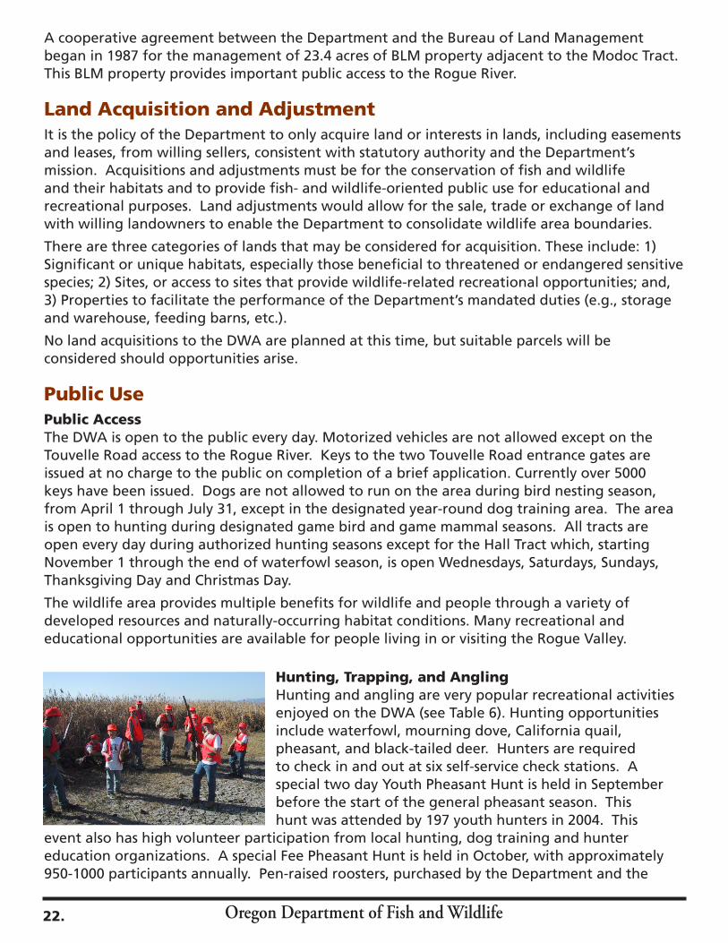
Hunting, Trapping, and AnglingHunting and angling are very popular recreational activities enjoyed on the DWA (see Table 6). Hunting opportunities include waterfowl, mourning dove, California quail, pheasant, and black-tailed deer. Hunters are required to check in and out at six self-service check stations. A special two day Youth Pheasant Hunt is held in September before the start of the general pheasant season. This hunt was attended by 197 youth hunters in 2004. This
event also has high volunteer participation from local hunting, dog training and hunter education organizations. A special Fee Pheasant Hunt is held in October, with approximately 950-1000 participants annually. Pen-raised roosters, purchased by the Department and the
22.

Oregon Department of Fish and Wildlife
Oregon Hunters Association, are released for both of these hunts. Events planned through the Department’s Becoming an Outdoors- Woman (BOW) program include a pheasant hunt and a dog training seminar. Waterfowl hunting takes place throughout the area, but is most productive in ten 3-acre flooded grain fields. There is heavy competition among hunters for these ten fields. There are no established permanent blinds. Hunter participation is also restricted in some areas of the Rogue River bottomlands due to poor access through thick vegetation.
Angling for Chinook salmon, coho salmon, summer and winter steelhead, and cutthroat and rainbow trout are popular on the Rogue River. An annual Youth Angling Enhancement Day is held in March for trout stocked in Whetstone Pond. In 2004 this event was attended by 248 youth and 214 parents. Warm water angling for large-mouth bass, bluegill, crappie, bullhead and carp is offered in the numerous local ponds and reservoirs.
Trapping of furbearers is allowed on the DWA, by permit, during general seasons. Trapping is used primarily to control animals such as beaver and muskrat which may damage water control structures, and to control other species such as foxes and raccoons that may create damage problems on neighboring properties.
Table 6. Estimated annual hunting, trapping, and angling use days on the Ken Denman Wildlife Area.
Activity Estimated Annual Use DaysHunting Deer 100Waterfowl 1,000Upland Birds 2,000 Trapping 200Angling 8,000
Total 11,300
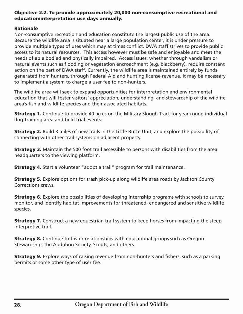
Non-consumptiveThe DWA is open to the public year around. Dog training, wildlife viewing, hiking, horseback riding, river boarding and wildlife photography are popular on the area. Table 7 describes activities and estimated annual use on the DWA. Dog training is one of the oldest and most popular activities on the DWA. The terrain on the Military Slough is considered to be some of the best on the west coast for retrieving dog field trials. Pointing dog and tracking events are also held. Several events with up to 200 entrants are held annually. Approximately 40 acres, near the intersection of Touvelle and Agate Roads, is designated as a year-round dog training area.
A self-guided interpretive trail is located on the Military Slough Unit to the south of Touvelle Road. A trail guide is available at the area headquarters on East Gregory Road. A paved disability-accessible path leading to a covered viewing platform overlooking Whetstone Pond is located near the wildlife area headquarters. This platform was donated by the Rogue Valley Chapter Oregon Hunters Association. Public access is limited to established trails on much of the area due to thick vegetation. At present, approximately 200 acres of the Modoc and Little Butte Units cannot be accessed because of the lack of trails.
23.
Oregon Department of Fish and Wildlife
Educational/InterpretiveThe DWA is used by a variety of educational groups including local school districts, Southern Oregon University, Rogue Valley Audubon Society educational program, Southern Oregon Headstart, various Scouting groups, the Job Council, and Oregon Stewardship. Educational groups can use the area on their own or arrange for guided tours by Department staff. Numerous student volunteer projects are completed yearly, including placing and maintaining wood duck boxes and bird houses, constructing nest platforms, picking up trash, building benches, maintaining trails, monitoring fish and bird species, and many other activities. Table 7. Estimated annual non-consumptive use days on the Ken Denman Wildlife Area.
Activity Estimated Annual Use Days
Wildlife Viewing 5,000Photography 1,000Dog Training 4,500Horseback Riding 1,500Hiking 5,000Education 1,500Other Miscellaneous 1,500
Total 20,000
Objectives and Strategies
Objectives and StrategiesAs stated previously, objectives are concise statements of what the Department wants to achieve, how much the Department wants to achieve, when and where to achieve it and who will be responsible for the work. Objectives derive from goals and provide the basis for determining strategies. Strategies describe the specific actions, tools, techniques or a combination of these elements used to meet an objective.
The following objectives and strategies identify the management activities and priorities of the Denman Wildlife Area Management Plan.
(Goal 1: To protect, enhance and restore habitats to benefit fish and wildlife species.)
Objective 1.1 To protect, enhance and restore 286 acres of upland habitats annually to benefit native and desirable non-native wildlife.
RationaleUpland habitat supports a wide variety of game and non-game wildlife and well as several sensitive species. This habitat includes native vegetative communities such as oak savannah, grassland and hardwood forest. Mature trees provide many important wildlife habitat components, including nest civilities, crevices under loose bark, insect habitat, and seeds and acorns for forage. Management activities such as conducting controlled burns, noxious weed removal, and placing of artificial nest structures are important tools among many that DWA staff use. The Ken Denman Wildlife Area has remnants of the original ecosystem of the Rogue Valley and DWA staff strives to maintain and restore these remnants, where possible. Strategies employed by the DWA will support many upland habitat conservation actions described in the Oregon Conservation Strategy.
24.
Oregon Department of Fish and Wildlife
Strategy 1. Identify habitat improvement projects which may include placement of bird and bat nest/roost boxes, controlled burning, seeding of native grasses, and development of forage areas.
Strategy 2. Conduct an area wide survey to determine the presence and extent of invasive and noxious weeds and develop control measures as necessary.
Strategy 3. Survey and identify age class, stand type, and condition of oak woodlands to determine silvicultural practices necessary to improve and increase wildlife habitat, restore natural range of vegetative seral stages, maintain a balanced age structure, and improve tree health.
Strategy 4. Seek partnerships with Partners in Flight International Bird Conservation Program, Klamath Bird Observatory, and the Audubon Society to identify habitat improvement projects for birds.
Objective 1.2 To protect, enhance and restore 730 acres of wetland, riparian and freshwater aquatic habitats annually for the benefit of native and desirable non-native fish and wildlife species.
RationaleNatural and artificially created wetlands provide habitat for many species of wildlife and other aquatic species. Wetlands offer food and cover to birds, small mammals and bats and provide materials for nesting for migrant and resident waterfowl, shorebirds and passerines. Riparian habitats provide large trees with nest cavities and other habitat components. Natural habitats can be enhanced by placing artificial nest structures. Streams and ponds on the area support a wide variety of anadromous and warm-water fish, reptiles, amphibians, mammals, and insects. Aquatic habitats on the DWA are important recreational and educational attractions to the public.
Strategy 1. Manage water levels on 3 reservoirs for flood control and to promote the growth of native vegetation.
Strategy 2. Maintain 50 wood duck nest structures, 70 songbird and 20 bat nest/roost boxes and install additional structures where needed.
Strategy 3. Mechanically cut 5 acres of Himalayan blackberry annually.
Strategy 4. Work with district staff to identify fish habitat improvement projects that may include placing large woody debris, removal of fish passage barriers, planting riparian vegetation, and seek partnerships with other agencies, sport groups or volunteers for implementation of such projects.
Strategy 5. Explore the possibility of returning Little Butte Creek to its original channel.
Objective 1.3 To protect and restore 720 acres of vernal pool habitat annually to benefit the native species associated with this unique habitat.
RationaleThe USFWS has designated 720 acres of critical vernal pool habitat on the DWA. Three federal and state designated threatened and endangered species are exclusively associated with this habitat. These include the vernal pool fairy shrimp, Cook’s desert parsley, and large flowered
25.
Oregon Department of Fish and Wildlife
wooly meadowfoam. Vernal pools have value for native flora, fauna, and for wildlife viewing, photography and education. Vernal pools have been damaged by past human activities, such as filling vernal pools, leveling, ripping of hardpan, and introduction of non-native weeds. The Oregon Conservation Strategy describes vernal pools as a ‘local and specialized habitat’ and many of the DWA strategies listed below support the conservation actions described in this document.
Strategy 1. Continue to partner with TNC and USFWS with monitoring of threatened and endangered vernal pool species. Strategy 2. Coordinate with TNC and USFWS to implement potential habitat improvement projects such as controlled burning, seeding, and noxious weed control activities.
Strategy 3. Seek partnerships and cooperative funding from other agencies that have threatened and endangered species responsibilities.
Strategy 4. Participate with Oregon Division of State Lands (DSL), USFWS, TNC and Jackson County in land use planning that affects DWA management and operations.
Objective 1.4 Maintain 122 acres of agricultural habitats to provide forage for native and desirable non-native wildlife.
RationaleAgricultural crops provide important forage as well as nesting, rearing, refuge and thermal cover for many species of wildlife. Grains such as sunflowers, millet, corn, sudan grass, barley and wheat are important food sources for migrating song birds and waterfowl. Irrigated grass and clover provides nesting and escape cover, and increases insect populations which are an important food source for young birds. Agricultural crops also provide food and cover for many small mammals. Grain fields are also desirable hunting areas for upland bird and waterfowl hunters.
Strategy 1. Maintain grain plantings on 30 acres for waterfowl forage.
Strategy 2. Build one additional 5-acre diked grain field on the Hall Tract.
Strategy 3. Provide up to 10 acres of forage crops to benefit upland game birds and non-game birds.
Strategy 4. Irrigate up to 10 acres of grassland annually to provide forage and nesting habitat for waterfowl and upland birds on the Hall Tract. Strategy 5. Explore the possibility of transferring un-used water rights to areas where they could be used to benefit wildlife.
Objective 1.5To maintain and enhance wildlife area facilities, structures, and equipment to conduct habitat management and public use projects on the wildlife area.
RationaleMany structures on the wildlife area are now 50 or more years old and are suffering from metal fatigue and deterioration. Some structures need to be repaired while others need simple aesthetic improvements. Properly functioning water control structures, culverts, headgates, and dams are needed to maintain wetland habitats and to protect neighboring lands. Maintenance
26.

Oregon Department of Fish and Wildlife
of bridges, trails, fences, gates, roads check stations, and viewing areas are necessary to ensure the safety of public users while they enjoy the wildlife area’s resources. Wetlands on the area produce mosquitoes that are vectors of diseases that can affect humans and livestock. DWA staff must cooperate with the local vector control district to assure that mosquitoes do not pose a threat to public health.
Strategy 1. Maintain 10 parking areas, 2 gates, 6 hunter check stations, 1 viewing platform, 3 miles of roads and 22 miles of trails.
Strategy 2. Prioritize repairs of structures including water control structures, fences, culverts, ditches, dikes and buildings based on the results of the maintenance master plan developed fall 2005.
Strategy 3. Build a new equipment barn on the Hall Tract to cover farm implements.
Strategy 4. Repair spillway and construct bridge on interpretive trail.
Strategy 5. Continue to cooperate with Jackson County Vector Control District to control mosquito populations.
(Goal 2: To provide a variety of quality wildlife oriented recreational and educational opportunities to the public which are compatible with Goal 1.)
Objective 2.1. To provide approximately 11,300 hunting, trapping, and angling use days annually.
RationaleThe DWA is funded entirely by hunter dollars through the Federal Aid to Wildlife Restoration Act (Pittman Robertson) (75%) and hunting license receipts (25%). Because the area is located near a large population center, it is a convenient destination for hunters and anglers alike. Special events for women and youth hunters are provided to the public. A wide variety of fishing opportunities are available year-round. Trapping of furbearers is a traditional activity, and is used to reduce damage to water control structures on the DWA and on surrounding properties.
Strategy 1. Continue to conduct the Youth Pheasant Hunt for 150-250 youth hunters annually.
Strategy 2. Continue to conduct the Fee Pheasant Hunt for 950-1000 hunters annually.
Strategy 3. Annually monitor hunting use of the area to review and possibly revise wildlife area hunting regulations to enhance the quality and safety of the area’s hunting program.
Strategy 4. Build 1 mile trail to ponds on the Rogue River Island for hunter access and habitat improvements.
Strategy 5. Enlarge the parking area on the Bear Creek Tract to accommodate 10 vehicles.
Strategy 6. Allow limited trapping of furbearers, by permit, according to state regulations.
Strategy 7. Provide opportunities for volunteers to maintain 8 peninsulas for angler access in ponds.
Strategy 8. Explore additional special hunt or angling events as public interest and staffing resources allow.
27.
Oregon Department of Fish and Wildlife
Objective 2.2. To provide approximately 20,000 non-consumptive recreational and education/interpretation use days annually.
Rationale Non-consumptive recreation and education constitute the largest public use of the area. Because the wildlife area is situated near a large population center, it is under pressure to provide multiple types of uses which may at times conflict. DWA staff strives to provide public access to its natural resources. This access however must be safe and enjoyable and meet the needs of able bodied and physically impaired. Access issues, whether through vandalism or natural events such as flooding or vegetation encroachment (e.g. blackberry), require constant action on the part of DWA staff. Currently, the wildlife area is maintained entirely by funds generated from hunters, through Federal Aid and hunting license revenue. It may be necessary to implement a system to charge a user fee to non-hunters.
The wildlife area will seek to expand opportunities for interpretation and environmental education that will foster visitors’ appreciation, understanding, and stewardship of the wildlife area’s fish and wildlife species and their associated habitats.
Strategy 1. Continue to provide 40 acres on the Military Slough Tract for year-round individual dog-training area and field trial events.
Strategy 2. Build 3 miles of new trails in the Little Butte Unit, and explore the possibility of connecting with other trail systems on adjacent property.
Strategy 3. Maintain the 500 foot trail accessible to persons with disabilities from the area headquarters to the viewing platform.
Strategy 4. Start a volunteer “adopt a trail” program for trail maintenance.
Strategy 5. Explore options for trash pick-up along wildlife area roads by Jackson County Corrections crews.
Strategy 6. Explore the possibilities of developing internship programs with schools to survey, monitor, and identify habitat improvements for threatened, endangered and sensitive wildlife species.
Strategy 7. Construct a new equestrian trail system to keep horses from impacting the steep interpretive trail.
Strategy 8. Continue to foster relationships with educational groups such as Oregon Stewardship, the Audubon Society, Scouts, and others.
Strategy 9. Explore ways of raising revenue from non-hunters and fishers, such as a parking permits or some other type of user fee.
28.
Oregon Department of Fish and Wildlife
Plan ImplementationFundingSince its inception in 1954, funding for the operation and maintenance of the DWA has been accomplished through an annual federal grant under the Federal Aid to Wildlife Restoration (WR) Program. This program was created with the passage of the Pittman- Robertson (PR) Act in 1937. The PR Act authorizes the U.S. Fish and Wildlife Service to cooperate with the States, through their respective State fish and wildlife departments, to fund wildlife restoration projects. Eligible types of projects include restoration, conservation, management, and enhancement of wild birds, wild mammals and their habitats, and providing for public use and benefit from these resources. Funding for WR is derived from a federal excise tax on the sale of firearms, ammunition, and archery equipment. Funding is then apportioned to states based on a mathematical formula of area of the state in square miles (50%) and total number of hunting licenses sold annually (50%). Under the program no state may receive more than 5%, nor less than 0.5% of the total money available.
To be eligible, States must have assented to the provisions of the PR Act and passed laws for the conservation of wildlife that include a prohibition against the diversion of license fees paid by hunters for any other purpose than the administration of the State fish and wildlife department. Another major requirement is that states have to contribute up to 25% of the total grant cost since federal participation is limited to 75% of eligible costs incurred under a grant. The Department provides its 25% cost share from annual license and tag revenues.Over the past 5 years, funding for the operation and maintenance of the DWA has averaged approximately $110,000 annually. To implement many of the proposed actions and achieve the objectives and goals of this plan, the Department will need additional funding and staff to undertake several types of projects including: upgrades of existing facilities, construction of new facilities or amenities (orientation kiosks and interpretive signs), and species and habitat monitoring.
Staffing / OrganizationThe Oregon Department of Fish and Wildlife manages sixteen wildlife areas throughout the state. The wildlife areas encompass approximately 200,000 acres and are found in all four
29.
Oregon Department of Fish and Wildlife
Department administrative regions. The Ken Denman Wildlife Area is located in the Southwest Region. One half-time Manager and one full-time Fish and Wildlife Technician 2 currently staff the area.
Compliance RequirementsThe Ken Denman Wildlife Area Long Range Management Plan was developed to comply with all Federal and State laws, Oregon Revised Statutes (ORSs), Oregon Administrative Rules (OARs), and Department policies. Full implementation of all components of this plan will require compliance with the laws, regulations, rules, and policies listed in Appendix F.
PartnershipsA number of other state, federal, and local agencies and interest groups assist with management activities on the DWA. These partners play an important role in helping the Department achieve its mission and reach the DWA goals. The Department will continue to rely on these and other partners in the future to help implement this plan and provide input for future updates. This plan identifies projects that provide new opportunities for existing or new partners. There is a great potential for more public participation and assistance in the management of the wildlife area, given its proximity to population centers such as Central Point, Medford, Grants Pass, and Ashland. The Department welcomes and encourages more public participation in the administration of the wildlife area. Adaptive ManagementThis plan provides for adaptive management of the wildlife area. Adaptive management is a flexible approach to long-term management of resources that is directed by the results of ongoing monitoring activities and latest data. Management techniques and strategies are regularly evaluated in light of monitoring results, new scientific understanding, and other new information. These periodic evaluations are used over time to adapt both management techniques and strategies to better achieve the area goals.
Monitoring is an essential component of adaptive management in general, and of this plan in particular; specific monitoring strategies have been integrated into the goals and objectives described in this plan whenever possible. Where possible, habitat management activities will be monitored to assess whether the desired effects on wildlife and habitat components have been achieved.
Plan Amendment and RevisionWildlife area management plans are meant to evolve with each individual wildlife area, and as such each plan will be formally revisited after 5 years and updated every 10 years. In the meantime, however, the Department will be reviewing and updating this plan periodically (at least as often as every 5 years) based on the results of the adaptive management program. This plan will also be informally reviewed by area staff while preparing annual work plans. It may also be reviewed during routine inspections or programmatic evaluations. Results of any or all
of these reviews may indicate a need to modify the plan. The goals and objectives described in this plan will not change until they are re-evaluated as part of the formal plan revision process. However, the strategies may be revised to better address changing circumstances or due to increased knowledge of the resources on the area. If changes are required, the level of public involvement and associated compliance requirements will be determined by the Department.
30.
Oregon Department of Fish and Wildlife
References
Beckham, S. D. 2002. Requiem for a People. Oregon State University Press, Corvallis, OR.
Borgias, D. 2004. Effects of Livestock Grazing and the Development of Grazing Best Management Practices for the Vernal Pool—Mounded Prairies of the Agate Desert, Jackson County, Oregon. The Nature Conservancy, Medford, Oregon.
Bowman, H. 1979. Environmental Assessment Report Kenneth Denman Wildlife Area. Oregon Department of Fish and Wildlife.
Collins, Jim; Cross, S.; Swisher, O. 1992, Wildlife of the Denman Wildlife Area. Oregon Department of Fish and Wildlife, Portland, OR
Himmel, E. 2004. Jackson County Habitat Guide. Rogue Valley Audubon Society, Medford OR.
Hopkins, J. W. III 1978. A Cultural Resources Survey of a Proposed Pond Excavation on The Denman Wildlife Area, Jackson County, Oregon. Southern Oregon State College, Ashland, Oregon
Janes, Stewart, Chair, and the Jackson County Checklist Committee 2002. Birds of Jackson County Oregon. Rogue Valley Audubon Society, Medford OR.
Jensen, E. C. 1994. Manual of Oregon Trees and Shrubs. Oregon State University, Corvallis OR.
Johnson, D. R. 1994. Soil Survey of Jackson County Area, Oregon. United States Department of Agriculture, Soil Conservation Service.
Kramer, G. 1992. Camp White, City in the Agate Desert. Camp White 50th Anniversary Committee, White City, OR.
ODFW Fish Presence Surveys, Central Point unpublished data
Oregon Game Commission 1949. Game Management Survey, Camp White, Jackson County.
Tucker, W. P. 1931. The History of Jackson County, Oregon. M.A. Thesis, the University of Washington, Seattle.
Whitsen, T. D. 2000. Weeds of the West. Western Society of Weed Science, Newark CA.
31.
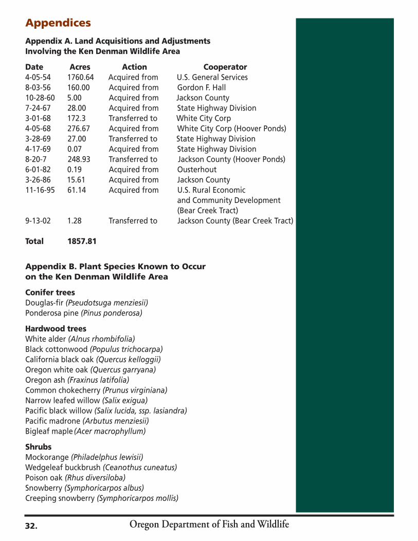
Oregon Department of Fish and Wildlife
Appendices
Appendix A. Land Acquisitions and Adjustments Involving the Ken Denman Wildlife Area
Date Acres Action Cooperator 4-05-54 1760.64 Acquired from U.S. General Services8-03-56 160.00 Acquired from Gordon F. Hall10-28-60 5.00 Acquired from Jackson County7-24-67 28.00 Acquired from State Highway Division3-01-68 172.3 Transferred to White City Corp4-05-68 276.67 Acquired from White City Corp (Hoover Ponds)3-28-69 27.00 Transferred to State Highway Division4-17-69 0.07 Acquired from State Highway Division8-20-7 248.93 Transferred to Jackson County (Hoover Ponds)6-01-82 0.19 Acquired from Ousterhout3-26-86 15.61 Acquired from Jackson County 11-16-95 61.14 Acquired from U.S. Rural Economic and Community Development (Bear Creek Tract)9-13-02 1.28 Transferred to Jackson County (Bear Creek Tract) Total 1857.81
Appendix B. Plant Species Known to Occuron the Ken Denman Wildlife Area
Conifer treesDouglas-fir (Pseudotsuga menziesii)Ponderosa pine (Pinus ponderosa)
Hardwood treesWhite alder (Alnus rhombifolia)Black cottonwood (Populus trichocarpa)California black oak (Quercus kelloggii)Oregon white oak (Quercus garryana)Oregon ash (Fraxinus latifolia)Common chokecherry (Prunus virginiana)Narrow leafed willow (Salix exigua)Pacific black willow (Salix lucida, ssp. lasiandra)Pacific madrone (Arbutus menziesii)Bigleaf maple (Acer macrophyllum)
ShrubsMockorange (Philadelphus lewisii)Wedgeleaf buckbrush (Ceanothus cuneatus)Poison oak (Rhus diversiloba)Snowberry (Symphoricarpos albus)Creeping snowberry (Symphoricarpos mollis)
32.

Oregon Department of Fish and Wildlife
Tall Oregon-grape (Berberis aquifolium) Ocean spray (Holodiscus discolor)Klamath plum (Prunus subcordata)Western dogwood (Cornus stolonifera)Nootka rose (Rosa nutkana)Scotch broom (Cytisus scoparius)
GrassesPacific meadow foxtail (Alopecurus pratensis)Chess (Bromus secalinus)Ripgut brome (Bromus rigidus)Cheatgrass (Bromus tectorum)Tufted hairgrass (Deschampsia cespitosa)Idaho fescue (Festuca idahoensis)Mediterranean barley (Hordeum marinum)Medusahead rye (Taeniatherum caput-medusae)Bluebunch wheatgrass (Agropyron spicatum)California oatgrass (Danthonia californica)Lemmon’s needlegrass (Acnatherum lemmonii)Pine bluegrass (Poa nevadensis)Largo tall wheatgrass (Agropyron elongatum)Tall fescue (Festuca spp)Timothy (Phleum pretense) Bulbous bluegrass (Poa bulbosa)Sandburg bluegrass (Poa secunda)Reed canarygrass (Phalaris arundinacea)Barnyardgrass (Echinochloa crus-galli)Bermudagrass (Cynodon dactylon)Common rye (Secale cereale)Rabbitfoot polypogon (Ploypogon monspeliensis)
LegumesElegant lupine (Lupinus lepidus)Bicolor lupine (Lupinus bicolor)Tomcat clover (Trifolium willdensoii)Yellow sweet clover (Melilotus officianalis)Subterranean clover (Trifolium subterranean)Rose clover (Trifolium hirtum)Red clover (Trifolium pretense)Alfalfa (Medicago sativa)Hairy vetch (Vicia villosa)
ForbsRedstem filaree (Erodium cicutarium)Self-heal (Prunella vulgaris)Western flax (Linum lewisii)Winecup clarkia (Clarkia purpurea)Fireweed (Epilobium anguatifolium)Needle navarretia (Nararretia intertexa)
33.
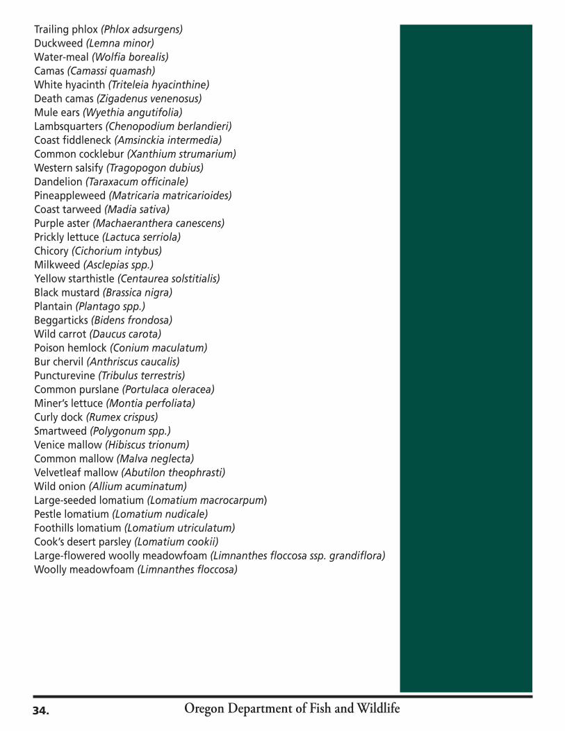
Oregon Department of Fish and Wildlife
Trailing phlox (Phlox adsurgens)Duckweed (Lemna minor)Water-meal (Wolfia borealis)Camas (Camassi quamash)White hyacinth (Triteleia hyacinthine)Death camas (Zigadenus venenosus)Mule ears (Wyethia angutifolia)Lambsquarters (Chenopodium berlandieri)Coast fiddleneck (Amsinckia intermedia)Common cocklebur (Xanthium strumarium)Western salsify (Tragopogon dubius)Dandelion (Taraxacum officinale)Pineappleweed (Matricaria matricarioides)Coast tarweed (Madia sativa)Purple aster (Machaeranthera canescens)Prickly lettuce (Lactuca serriola)Chicory (Cichorium intybus)Milkweed (Asclepias spp.)Yellow starthistle (Centaurea solstitialis)Black mustard (Brassica nigra)Plantain (Plantago spp.)Beggarticks (Bidens frondosa) Wild carrot (Daucus carota)Poison hemlock (Conium maculatum)Bur chervil (Anthriscus caucalis)Puncturevine (Tribulus terrestris)Common purslane (Portulaca oleracea)Miner’s lettuce (Montia perfoliata)Curly dock (Rumex crispus)Smartweed (Polygonum spp.)Venice mallow (Hibiscus trionum)Common mallow (Malva neglecta)Velvetleaf mallow (Abutilon theophrasti)Wild onion (Allium acuminatum)Large-seeded lomatium (Lomatium macrocarpum)Pestle lomatium (Lomatium nudicale)Foothills lomatium (Lomatium utriculatum)Cook’s desert parsley (Lomatium cookii) Large-flowered woolly meadowfoam (Limnanthes floccosa ssp. grandiflora)Woolly meadowfoam (Limnanthes floccosa)
34.
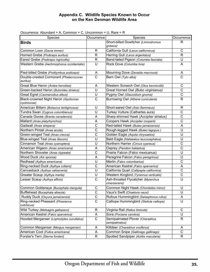
Oregon Department of Fish and Wildlife 35.
Appendix C. Wildlife Species Known to Occur on the Ken Denman Wildlife Area
Occurrence: Abundant = A, Common = C, Uncommon = U, Rare = R Species Occurrence Species Occurrence
Birds Short-billed Dowitcher (Limnodromus griseus)
R
Common Loon (Gavia immer) R California Gull (Larus californicus) CHorned Grebe (Podiceps auritus) R Herring Gull (Larus argentatus) REared Grebe (Podiceps nigricollis) R Band-tailed Pigeon (Columba fasciata) UWestern Grebe (Aechmophorus occidentalis) U Rock Dove (Columba livia) A
Pied-billed Grebe (Podilymbus podiceps) A Mourning Dove (Zenaida macroura) ADouble-crested Cormorant (Phalacrocorax auritus)
C Barn Owl (Tyto alba) C
Great Blue Heron (Ardea herodias) A Western Screech Owl (Otus kennicottii) CGreen-backed Heron (Butorides striatus) U Great Horned Owl (Bubo virginianus) CGreat Egret (Casmerodius albus) U Pygmy Owl (Glaucidium gnoma) CBlack-crowned Night Heron (Nycticoraxnyctricorax)
C Burrowing Owl (Athene cunicularia) R
American Bittern (Botaurus lentiginosus) U Short-eared Owl (Asio flammeus) RTundra Swan (Cygnus columbianus) U Turkey Vulture (Cathartes aura) C Canada Goose (Branta canadensis) A Sharp-shinned Hawk (Accipiter striatus) C Mallard (Anas platyrhynchos) A Coopers Hawk (Accipiter cooperii) CGadwall (Anas strepera) C Red-tailed Hawk (Buteo jamaicensis) ANorthern Pintail (Anas acuta) C Rough-legged Hawk (Buteo lagopus ) UGreen-winged Teal (Anas crecca) C Golden Eagle (Aquila chrysaetos) UBlue-winged Teal (Anas discors) U Bald Eagle (Haliaeetus leucocephalus) UCinnamon Teal (Anas cyanoptera) U Northern Harrier (Circus cyaneus) CAmerican Wigeon (Anas americana) A Osprey (Pandion haliaetus) CNorthern Shoveler (Anas clypeata) C Prairie Falcon (Falco mexicanus) U Wood Duck (Aix sponsa) A Peregrine Falcon (Falco peregrinus) URedhead (Aythya americana) U Merlin (Falco columbarius) CRing-necked Duck (Aythya collaris) C American Kestrel (Falco sparverius) ACanvasback (Aythya valiseneria) U California Quail (Callipepla californica) CGreater Scaup (Aythya marila) U Western Kingbird (Tyrannus verticalis) CLesser Scaup (Aythya affinis) C Ash-throated Flycatcher (Myiarchus
cinerascens) U
Common Goldeneye (Bucephala clangula) C Common Night Hawk (Chordeiles minor) UBufflehead (Bucephala albeola) C Vaux's Swift (Chaetura vauxi) U Ruddy Duck (Oxyura jamaicensis) C Rufous Hummingbird (Selasphorus rufus) ARing-necked Pheasant (Phasianus colchicus)
C Calliope Hummingbird (Stellula calliope) U
Wild Turkey (Meleagris gallopavo) R Virginia Rail (Rallus limicola) CAmerican Kestrel (Falco sparverius) A Sora (Porzana carolina) UHooded Merganser (Lophodytes cucullatus) C Semipalmated Plover (Charadrius
semipalmatus) R
Common Merganser (Mergus merganser) A Killdeer (Charadrius vociferus) AAmerican Coot (Fulica americana) A Common Snipe (Gallinago gallinago) CForster's Tern (Sterna forsteri) R Spotted Sandpiper (Actitis macularia) R
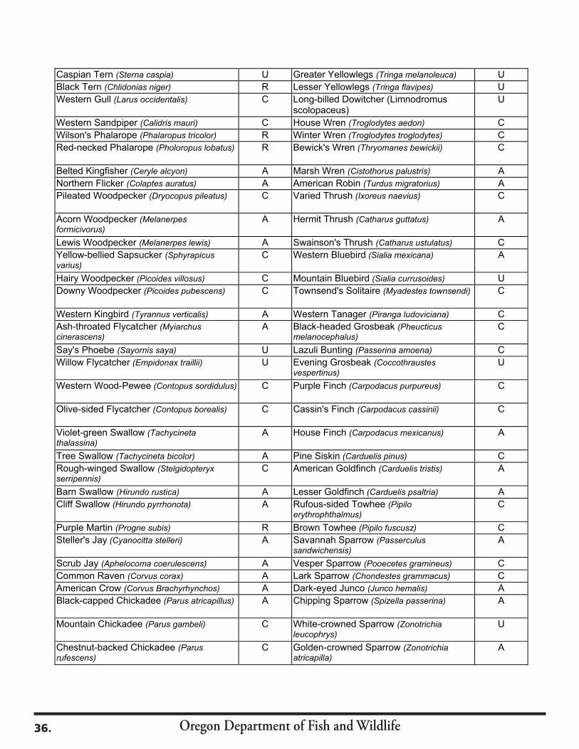
Oregon Department of Fish and Wildlife36.
Caspian Tern (Sterna caspia) U Greater Yellowlegs (Tringa melanoleuca) UBlack Tern (Chlidonias niger) R Lesser Yellowlegs (Tringa flavipes) UWestern Gull (Larus occidentalis) C Long-billed Dowitcher (Limnodromus
scolopaceus) U
Western Sandpiper (Calidris mauri) C House Wren (Troglodytes aedon) CWilson's Phalarope (Phalaropus tricolor) R Winter Wren (Troglodytes troglodytes) CRed-necked Phalarope (Pholoropus lobatus) R Bewick's Wren (Thryomanes bewickii) C
Belted Kingfisher (Ceryle alcyon) A Marsh Wren (Cistothorus palustris) ANorthern Flicker (Colaptes auratus) A American Robin (Turdus migratorius) APileated Woodpecker (Dryocopus pileatus) C Varied Thrush (Ixoreus naevius) C
Acorn Woodpecker (Melanerpes formicivorus)
A Hermit Thrush (Catharus guttatus) A
Lewis Woodpecker (Melanerpes lewis) A Swainson's Thrush (Catharus ustulatus) CYellow-bellied Sapsucker (Sphyrapicus varius)
C Western Bluebird (Sialia mexicana) A
Hairy Woodpecker (Picoides villosus) C Mountain Bluebird (Sialia currusoides) UDowny Woodpecker (Picoides pubescens) C Townsend's Solitaire (Myadestes townsendi) C
Western Kingbird (Tyrannus verticalis) A Western Tanager (Piranga ludoviciana) CAsh-throated Flycatcher (Myiarchus cinerascens)
A Black-headed Grosbeak (Pheucticus melanocephalus)
C
Say's Phoebe (Sayornis saya) U Lazuli Bunting (Passerina amoena) CWillow Flycatcher (Empidonax traillii) U Evening Grosbeak (Coccothraustes
vespertinus) U
Western Wood-Pewee (Contopus sordidulus) C Purple Finch (Carpodacus purpureus) C
Olive-sided Flycatcher (Contopus borealis) C Cassin's Finch (Carpodacus cassinii) C
Violet-green Swallow (Tachycineta thalassina)
A House Finch (Carpodacus mexicanus) A
Tree Swallow (Tachycineta bicolor) A Pine Siskin (Carduelis pinus) CRough-winged Swallow (Stelgidopteryxserripennis)
C American Goldfinch (Carduelis tristis) A
Barn Swallow (Hirundo rustica) A Lesser Goldfinch (Carduelis psaltria) ACliff Swallow (Hirundo pyrrhonota) A Rufous-sided Towhee (Pipilo
erythrophthalmus) C
Purple Martin (Progne subis) R Brown Towhee (Pipilo fuscusz) CSteller's Jay (Cyanocitta stelleri) A Savannah Sparrow (Passerculus
sandwichensis) A
Scrub Jay (Aphelocoma coerulescens) A Vesper Sparrow (Pooecetes gramineus) CCommon Raven (Corvus corax) A Lark Sparrow (Chondestes grammacus) CAmerican Crow (Corvus Brachyrhynchos) A Dark-eyed Junco (Junco hemalis) ABlack-capped Chickadee (Parus atricapillus) A Chipping Sparrow (Spizella passerina) A
Mountain Chickadee (Parus gambeli) C White-crowned Sparrow (Zonotrichia leucophrys)
U
Chestnut-backed Chickadee (Parusrufescens)
C Golden-crowned Sparrow (Zonotrichia atricapilla)
A
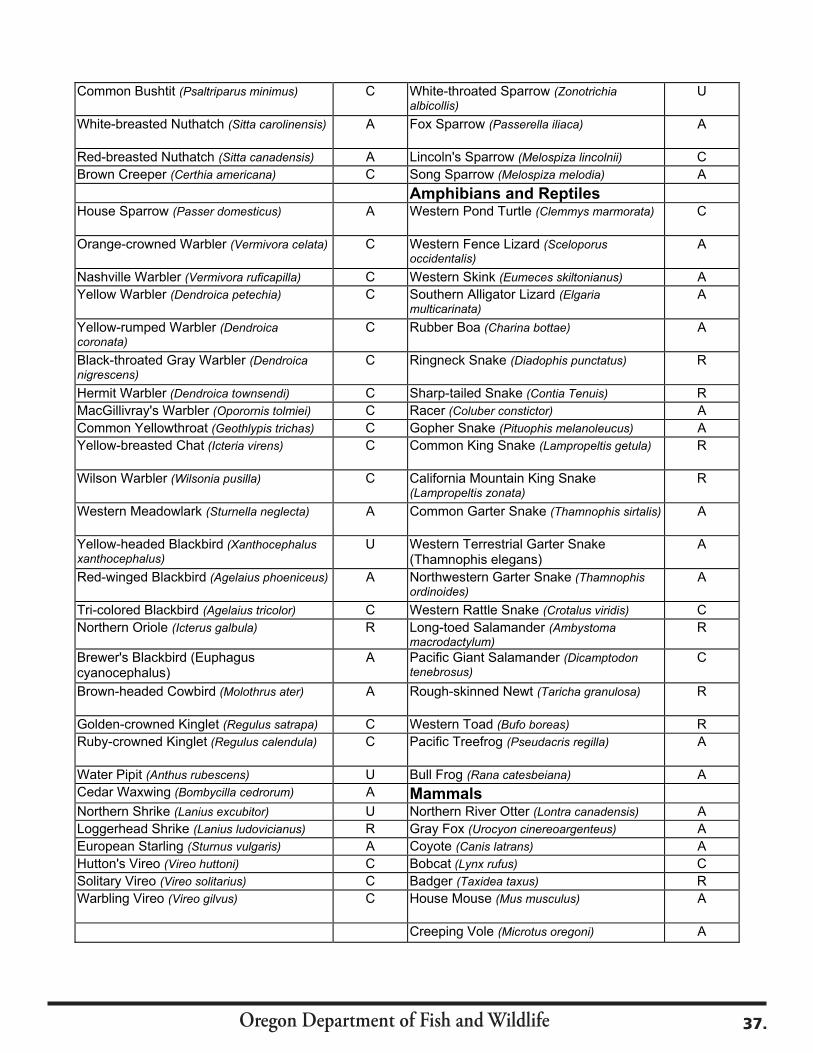
Oregon Department of Fish and Wildlife 37.
Common Bushtit (Psaltriparus minimus) C White-throated Sparrow (Zonotrichia albicollis)
U
White-breasted Nuthatch (Sitta carolinensis) A Fox Sparrow (Passerella iliaca) A
Red-breasted Nuthatch (Sitta canadensis) A Lincoln's Sparrow (Melospiza lincolnii) CBrown Creeper (Certhia americana) C Song Sparrow (Melospiza melodia) A
Amphibians and ReptilesHouse Sparrow (Passer domesticus) A Western Pond Turtle (Clemmys marmorata) C
Orange-crowned Warbler (Vermivora celata) C Western Fence Lizard (Sceloporus occidentalis)
A
Nashville Warbler (Vermivora ruficapilla) C Western Skink (Eumeces skiltonianus) AYellow Warbler (Dendroica petechia) C Southern Alligator Lizard (Elgaria
multicarinata) A
Yellow-rumped Warbler (Dendroica coronata)
C Rubber Boa (Charina bottae) A
Black-throated Gray Warbler (Dendroica nigrescens)
C Ringneck Snake (Diadophis punctatus) R
Hermit Warbler (Dendroica townsendi) C Sharp-tailed Snake (Contia Tenuis) RMacGillivray's Warbler (Oporornis tolmiei) C Racer (Coluber constictor) ACommon Yellowthroat (Geothlypis trichas) C Gopher Snake (Pituophis melanoleucus) AYellow-breasted Chat (Icteria virens) C Common King Snake (Lampropeltis getula) R
Wilson Warbler (Wilsonia pusilla) C California Mountain King Snake (Lampropeltis zonata)
R
Western Meadowlark (Sturnella neglecta) A Common Garter Snake (Thamnophis sirtalis) A
Yellow-headed Blackbird (Xanthocephalus xanthocephalus)
U Western Terrestrial Garter Snake (Thamnophis elegans)
A
Red-winged Blackbird (Agelaius phoeniceus) A Northwestern Garter Snake (Thamnophis ordinoides)
A
Tri-colored Blackbird (Agelaius tricolor) C Western Rattle Snake (Crotalus viridis) CNorthern Oriole (Icterus galbula) R Long-toed Salamander (Ambystoma
macrodactylum) R
Brewer's Blackbird (Euphagus cyanocephalus)
A Pacific Giant Salamander (Dicamptodon tenebrosus)
C
Brown-headed Cowbird (Molothrus ater) A Rough-skinned Newt (Taricha granulosa) R
Golden-crowned Kinglet (Regulus satrapa) C Western Toad (Bufo boreas) RRuby-crowned Kinglet (Regulus calendula) C Pacific Treefrog (Pseudacris regilla) A
Water Pipit (Anthus rubescens) U Bull Frog (Rana catesbeiana) ACedar Waxwing (Bombycilla cedrorum) A MammalsNorthern Shrike (Lanius excubitor) U Northern River Otter (Lontra canadensis) ALoggerhead Shrike (Lanius ludovicianus) R Gray Fox (Urocyon cinereoargenteus) AEuropean Starling (Sturnus vulgaris) A Coyote (Canis latrans) AHutton's Vireo (Vireo huttoni) C Bobcat (Lynx rufus) CSolitary Vireo (Vireo solitarius) C Badger (Taxidea taxus) RWarbling Vireo (Vireo gilvus) C House Mouse (Mus musculus) A
Creeping Vole (Microtus oregoni) A
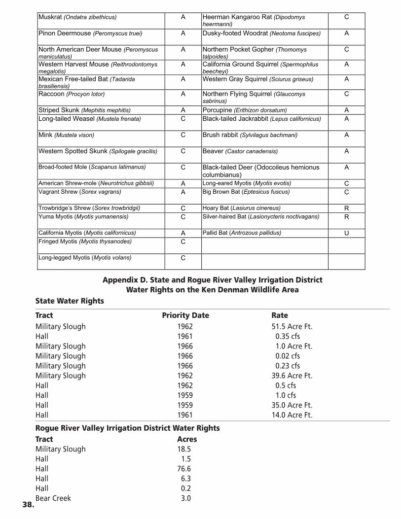
Appendix D. State and Rogue River Valley Irrigation District Water Rights on the Ken Denman Wildlife Area
State Water Rights
Tract Priority Date RateMilitary Slough 1962 51.5 Acre Ft.Hall 1961 0.35 cfsMilitary Slough 1966 1.0 Acre Ft.Military Slough 1966 0.02 cfsMilitary Slough 1966 0.23 cfsMilitary Slough 1962 39.6 Acre Ft.Hall 1962 0.5 cfsHall 1959 1.0 cfsHall 1959 35.0 Acre Ft.Hall 1961 14.0 Acre Ft.
Rogue River Valley Irrigation District Water RightsTract AcresMilitary Slough 18.5Hall 1.5Hall 76.6Hall 6.3Hall 0.2Bear Creek 3.0
38.
Muskrat (Ondatra zibethicus) A Heerman Kangaroo Rat (Dipodomys heermanni)
C
Pinon Deermouse (Peromyscus truei) A Dusky-footed Woodrat (Neotoma fuscipes) A
North American Deer Mouse (Peromyscus maniculatus)
A Northern Pocket Gopher (Thomomys talpoides)
C
Western Harvest Mouse (Reithrodontomys megalotis)
A California Ground Squirrel (Spermophilus beecheyi)
A
Mexican Free-tailed Bat (Tadarida brasiliensis)
A Western Gray Squirrel (Sciurus griseus) A
Raccoon (Procyon lotor) A Northern Flying Squirrel (Glaucomys sabrinus)
C
Striped Skunk (Mephitis mephitis) A Porcupine (Erithizon dorsatum) ALong-tailed Weasel (Mustela frenata) C Black-tailed Jackrabbit (Lepus californicus) A
Mink (Mustela vison) C Brush rabbit (Sylvilagus bachmani) A
Western Spotted Skunk (Spilogale gracilis) C Beaver (Castor canadensis) A
Broad-footed Mole (Scapanus latimanus) C Black-tailed Deer (Odocoileus hemionus columbianus)
A
American Shrew-mole (Neurotrichus gibbsii) A Long-eared Myotis (Myotis evotis) CVagrant Shrew (Sorex vagrans) A Big Brown Bat (Eptesicus fuscus) C
Trowbridge’s Shrew (Sorex trowbridgii) C Hoary Bat (Lasiurus cinereus) RYuma Myotis (Myotis yumanensis) C Silver-haired Bat (Lasionycteris noctivagans) R
California Myotis (Myotis californicus) A Pallid Bat (Antrozous pallidus) UFringed Myotis (Myotis thysanodes) C
Long-legged Myotis (Myotis volans) C

Oregon Department of Fish and Wildlife 39.
Appendix E. Easements and Access Agreements on the Ken Denman Wildlife Area
Easements
Principles Purpose Date Acres Cal-Ore Power Co. Powerline 3/25/1955 <1 Veterans Administration 4/4/1955 1.57 Hutchings & Hodgson 11/24/1959 1.14 Frin Monia, Eldred E. 3/4/1960 2.5 Wattenberg, Adolph T. 6/12/1961 1.52 White City Sanitary Dist. Sewage Lagoon 8/20/1963 <1 Pac Power and Light Co. Powerline 8/9/1965 <1 Pac Power and Light Co. Powerline 2/25/1966 <1 Monia & H 1/8/1968 2.5Wells, Donald V. & Z 1/9/1968 0.9Walch, Kenneth N. 1/9/1968 4.89White City Corp 5/2/1968 0.19 Monia, Eldred E. 7/30/1969 0.9Pac Power and Light Co. Powerline 5/4/1972 <1 OR Dept. of Transportation Pipeline 4/21/1976 <1 Burrill Lumber Co. 6/1/1979 <1Burrill Lumber Co. Roadway 6/18/1979 <1City of Medford Pipeline 3/20/1981 <1Pac Power and Light Co. Powerpole 6/13/1985 <1Pac Power and Light Co. Powerline 1/19/1988 <1Pacificorp Powerline 10/6/1995 <1Pacificorp Powerline 12/29/1997 <1Cascade Wood Products Well 5/3/2002 <1David Evans & Assoc. Habitat Monitoring 7/31/2003 <1
Access Agreements
Principles Purpose DateVanwey, WayneRoad 4/1/1984OR Dept. of Environmental QualityPermit 9/16/1985
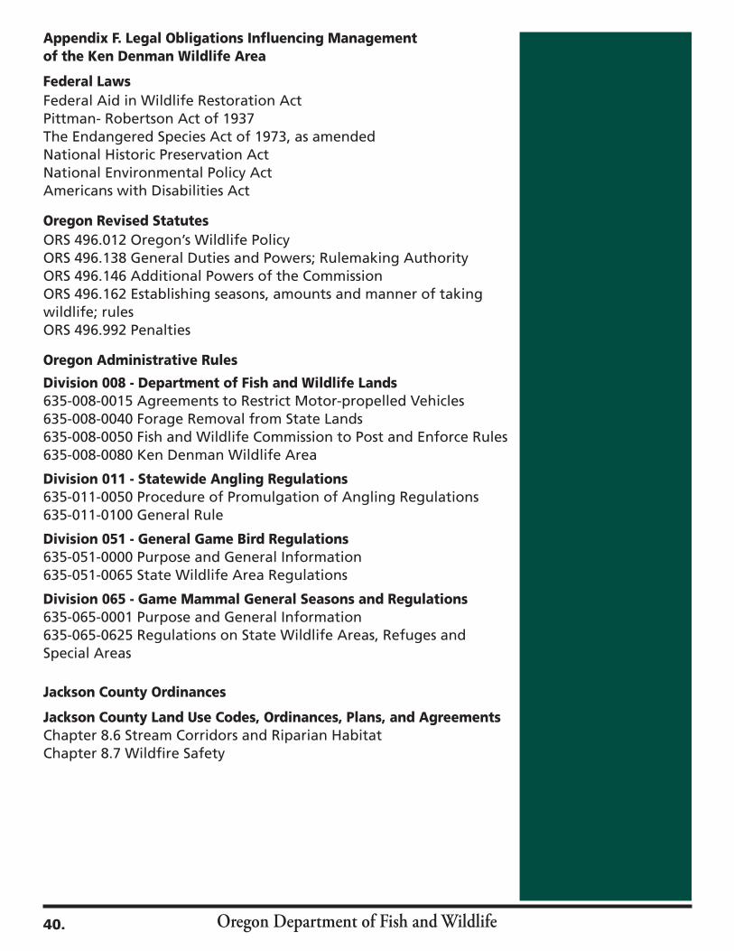
Oregon Department of Fish and Wildlife40.
Appendix F. Legal Obligations Influencing Management of the Ken Denman Wildlife Area
Federal LawsFederal Aid in Wildlife Restoration ActPittman- Robertson Act of 1937The Endangered Species Act of 1973, as amendedNational Historic Preservation ActNational Environmental Policy ActAmericans with Disabilities Act
Oregon Revised StatutesORS 496.012 Oregon’s Wildlife PolicyORS 496.138 General Duties and Powers; Rulemaking AuthorityORS 496.146 Additional Powers of the CommissionORS 496.162 Establishing seasons, amounts and manner of taking wildlife; rulesORS 496.992 Penalties
Oregon Administrative Rules
Division 008 - Department of Fish and Wildlife Lands635-008-0015 Agreements to Restrict Motor-propelled Vehicles635-008-0040 Forage Removal from State Lands635-008-0050 Fish and Wildlife Commission to Post and Enforce Rules635-008-0080 Ken Denman Wildlife Area
Division 011 - Statewide Angling Regulations635-011-0050 Procedure of Promulgation of Angling Regulations635-011-0100 General Rule
Division 051 - General Game Bird Regulations635-051-0000 Purpose and General Information 635-051-0065 State Wildlife Area Regulations
Division 065 - Game Mammal General Seasons and Regulations635-065-0001 Purpose and General Information 635-065-0625 Regulations on State Wildlife Areas, Refuges and Special Areas
Jackson County Ordinances
Jackson County Land Use Codes, Ordinances, Plans, and AgreementsChapter 8.6 Stream Corridors and Riparian HabitatChapter 8.7 Wildfire Safety
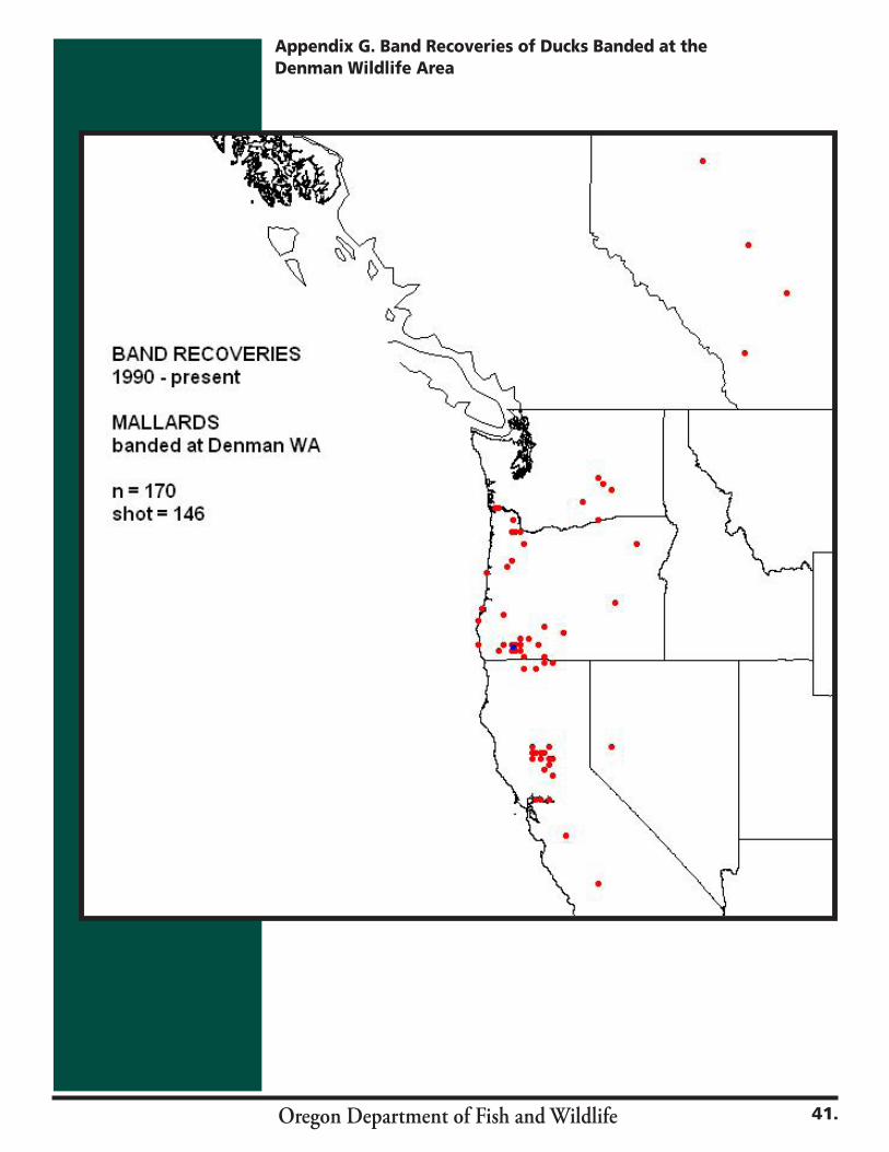
Oregon Department of Fish and Wildlife 41.
Appendix G. Band Recoveries of Ducks Banded at the Denman Wildlife Area
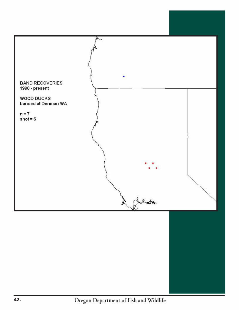
Oregon Department of Fish and Wildlife42.

Oregon Department of Fish and Wildlife

Oregon Department of Fish and Wildlife