kg 2025: refigured urbanism plan
DESCRIPTION
Master Plan proposal for Kiryat Gat.TRANSCRIPT
PREPARED FOR: THE CITY OF KIRYAT GAT, ISRAEL
PREPARED BY: GRADUATE STUDENTS OF:MIT DEPARTMENT OF URBAN STUDIES & PLANNINGTAU LABORATORY FOR CONTEMPORARY URBAN DESIGN
UNDER THE GUIDANCE OF: PROF. TALI HATUKA, TEL-AVIV UNIVERSITY PROF. ERAN BEN-JOSEPH, MIT
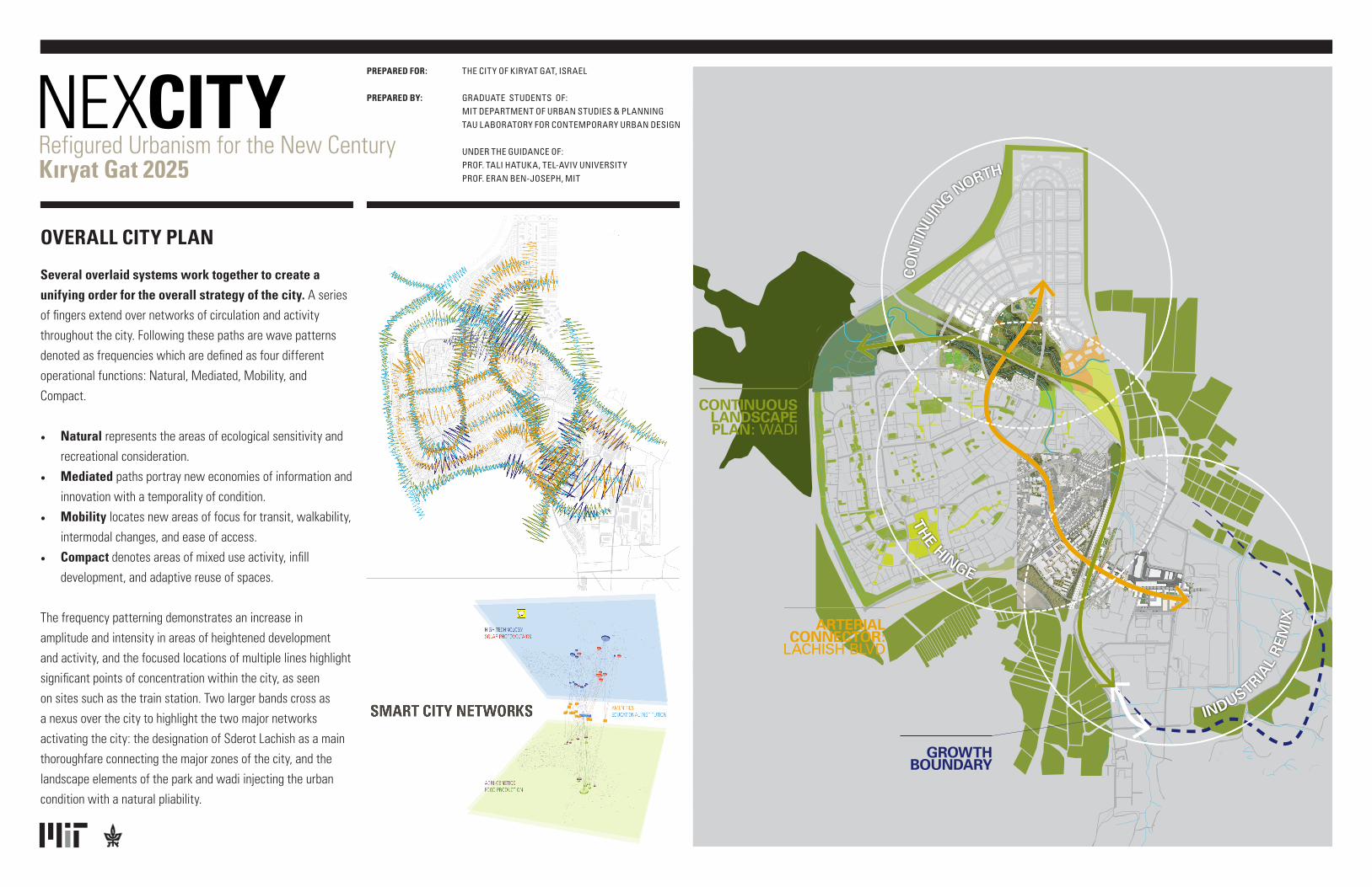
Several overlaid systems work together to create a unifying order for the overall strategy of the city. A series of fingers extend over networks of circulation and activity throughout the city. Following these paths are wave patterns denoted as frequencies which are defined as four different operational functions: Natural, Mediated, Mobility, and Compact.
• Natural represents the areas of ecological sensitivity and recreational consideration.
• Mediated paths portray new economies of information and innovation with a temporality of condition.
• Mobility locates new areas of focus for transit, walkability, intermodal changes, and ease of access.
• Compact denotes areas of mixed use activity, infill development, and adaptive reuse of spaces.
The frequency patterning demonstrates an increase in amplitude and intensity in areas of heightened development and activity, and the focused locations of multiple lines highlight significant points of concentration within the city, as seen on sites such as the train station. Two larger bands cross as a nexus over the city to highlight the two major networks activating the city: the designation of Sderot Lachish as a main thoroughfare connecting the major zones of the city, and the landscape elements of the park and wadi injecting the urban condition with a natural pliability.
OVERALL CITY PLAN
CONTINUOUS LANDSCAPE PLAN: WADI
ARTERIAL CONNECTOR:
LACHISH BLVD
GROWTH BOUNDARY
INDUSTRIAL
REM
IX
THE HINGE
CO
NTI
NU
IN
G NORTH
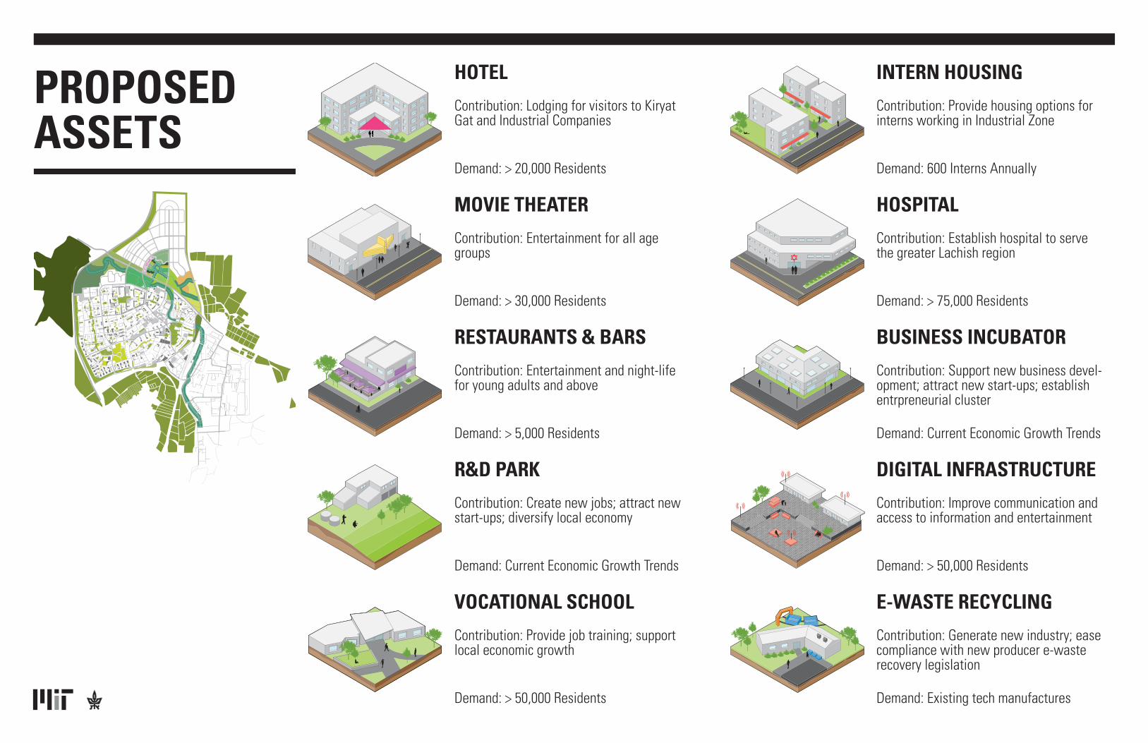
HOTEL
Contribution: Lodging for visitors to Kiryat Gat and Industrial Companies
Demand: > 20,000 Residents
INTERN HOUSING
Contribution: Provide housing options for interns working in Industrial Zone
Demand: 600 Interns Annually
R&D PARK
Contribution: Create new jobs; attract new start-ups; diversify local economy
Demand: Current Economic Growth Trends
DIGITAL INFRASTRUCTURE
Contribution: Improve communication and access to information and entertainment
Demand: > 50,000 Residents
E-WASTE RECYCLING
Contribution: Generate new industry; ease compliance with new producer e-waste recovery legislation
Demand: Existing tech manufactures
MOVIE THEATER
Contribution: Entertainment for all age groups
Demand: > 30,000 Residents
HOSPITAL
Contribution: Establish hospital to serve the greater Lachish region
Demand: > 75,000 Residents
VOCATIONAL SCHOOL
Contribution: Provide job training; support local economic growth
Demand: > 50,000 Residents
RESTAURANTS & BARS
Contribution: Entertainment and night-life for young adults and above
Demand: > 5,000 Residents
BUSINESS INCUBATOR
Contribution: Support new business devel-opment; attract new start-ups; establish entrpreneurial cluster
Demand: Current Economic Growth Trends
PROPOSEDASSETS

CONTINUING NORTH: ACTIVE & PRODUCTIVE LANDSCAPES
The city of Kiryat Gat is planning to expand with a large development to the north of Route 35, a major east-west connector for Southern Israel. This plan will expand the city at a large scale, accommodating an increase of 25,000 residents.
Our project critiques this plan, which is not without positives, but is flawed in several key respects. Most importantly, the current proposal may bifurcate an already disjointed city—missing an opportunity to take advantage of many of Kiryat Gat’s spatial, social and economic assets. Our plan is to focus on and take advantage of these assets and continue them into the North, tying what could be two very disparate areas into one cohesive city.
Our proposal has two main goals beyond the original plan for the North: to emphasize connectivity and to prioritize the natural systems in the area. We looked closely at three elements that offer physical and programmatic directions that work with, but ideally will strengthen, the proposed development:
1. Enhanced road connections that increase accessibility to the city and across the seam of Route 35, as well as mobility between the new northern neighborhoods and the existing city.
2. A landscape plan for the large open space between the two areas that emphasizes indigenous landscape forms and productive uses of hybrid forms of park space.
3. And a proposal for a mixed-use R&D zone that takes advantage of the large park next door.
CONTINUING NORTH
THE HINGE: URBAN CORE
The plan for the Hinge is focused on creating a vibrant, mixed-use city center that draws from and connects the municipal core of the city and the current industrial zone. The plan is based on several implementation concepts. The first, circulation and public passage, is focused on creating public and transparent ground levels of municipal functions interconnected with existing public assets such as pedestrian pathways and plazas. Pedestrian networks utilize passive climatological solutions to encourage year-round pedestrian use. The second, urban infill and adaptation, is focused on utilizing strategic densification by developing vacant and underutilized lots within the existing city and adapting existing urban fabric to create dense residential and commercial neighborhoods. Finally, our economic development strategy is focused on developing mixed-use structures and promoting human-scale street activity. Denser development will result in stronger continuity between commercial and residential uses in different parts of the city.
Our plan for the Hinge focuses primarily on a large-scale redevelopment of the Wedge into a mixed-use city center. Our proposal involves moving the train tracks below grade so a new train station can be built at grade with a road connection into the industrial zone, bridging the two major parts of the city. Major development and streetscape renovations along Sderot Lachish aim to turn this into an iconic street running the length of the city, from the northern development to Intel. The heart of Lachish will be in the Wedge, with mixed-use buildings contain-ing storefronts, cafes, and municipal services on the ground level and residences above. Parked cars will shield pedestrians, bikers, and diners from traffic and tree cover will shield them from the sun.
THE HINGE
USE
Mixed Use
Commercial
Office
Residential
Public Facilities
Institutional
Parking
NEW AND ADPATIVE LAND USE PATTERNS
Housing300,000 Square Meters
Commercial 52,000 Square Meters
Public/Institutional62,000 Square Meters
Office11,000 Square Meters
Parking15,000 Square Meters
USE
Mixed Use
Commercial
Office
Residential
Public Facilities
Institutional
Parking
NEW AND ADPATIVE LAND USE PATTERNS
Housing300,000 Square Meters
Commercial 52,000 Square Meters
Public/Institutional62,000 Square Meters
Office11,000 Square Meters
Parking15,000 Square Meters
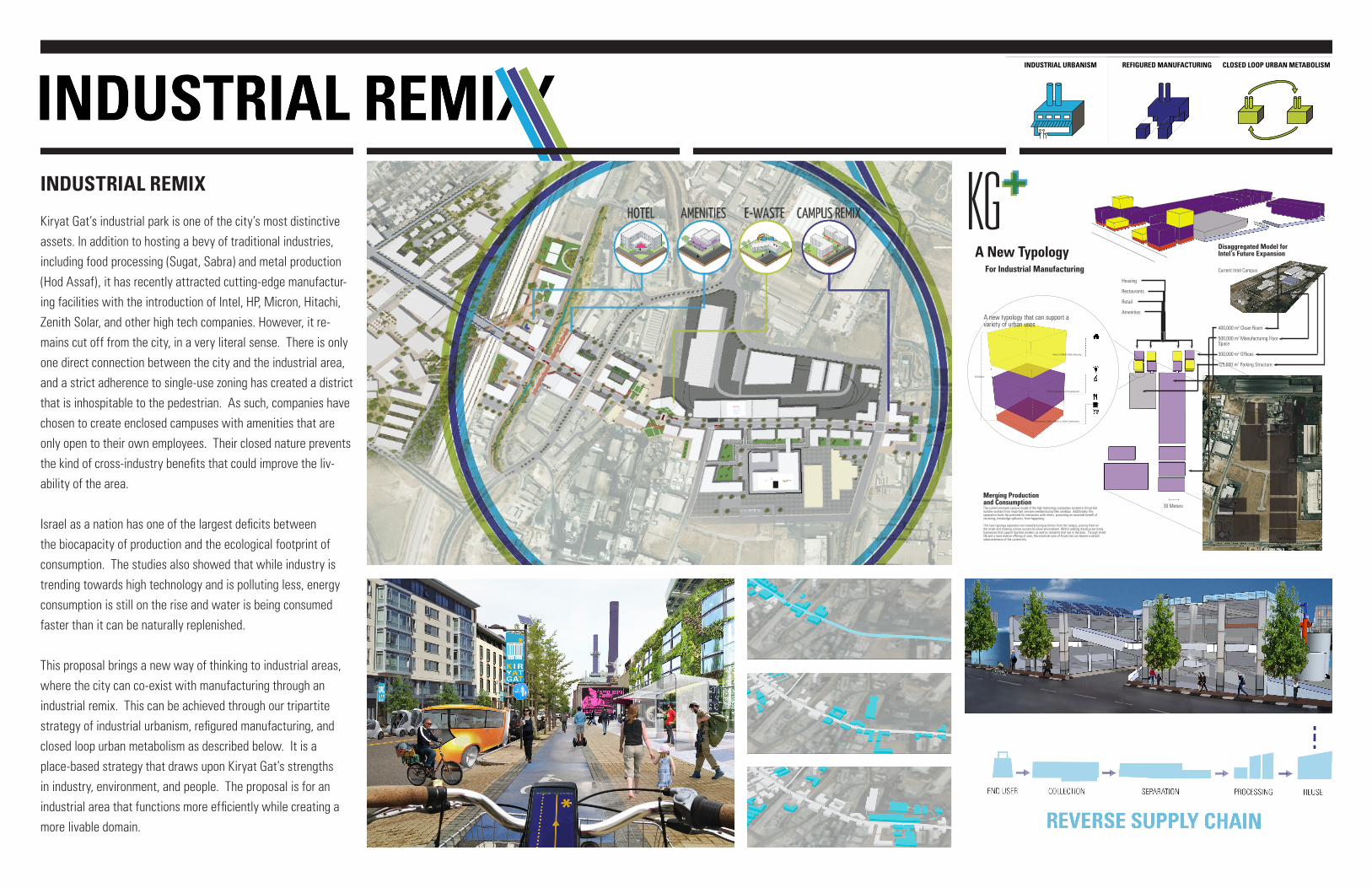
REFIGURED MANUFACTURING CLOSED LOOP URBAN METABOLISMINDUSTRIAL URBANISM REFIGURED MANUFACTURING CLOSED LOOP URBAN METABOLISMINDUSTRIAL URBANISM REFIGURED MANUFACTURING CLOSED LOOP URBAN METABOLISMINDUSTRIAL URBANISM
Kiryat Gat’s industrial park is one of the city’s most distinctive assets. In addition to hosting a bevy of traditional industries, including food processing (Sugat, Sabra) and metal production (Hod Assaf), it has recently attracted cutting-edge manufactur-ing facilities with the introduction of Intel, HP, Micron, Hitachi, Zenith Solar, and other high tech companies. However, it re-mains cut off from the city, in a very literal sense. There is only one direct connection between the city and the industrial area, and a strict adherence to single-use zoning has created a district that is inhospitable to the pedestrian. As such, companies have chosen to create enclosed campuses with amenities that are only open to their own employees. Their closed nature prevents the kind of cross-industry benefits that could improve the liv-ability of the area.
Israel as a nation has one of the largest deficits between the biocapacity of production and the ecological footprint of consumption. The studies also showed that while industry is trending towards high technology and is polluting less, energy consumption is still on the rise and water is being consumed faster than it can be naturally replenished.
This proposal brings a new way of thinking to industrial areas, where the city can co-exist with manufacturing through an industrial remix. This can be achieved through our tripartite strategy of industrial urbanism, refigured manufacturing, and closed loop urban metabolism as described below. It is a place-based strategy that draws upon Kiryat Gat’s strengths in industry, environment, and people. The proposal is for an industrial area that functions more efficiently while creating a more livable domain.
INDUSTRIAL REMIX
TEAMKIRYAT GAT 2025
MICHAEL KAPLANSTEPHEN KENNEDYJARED PRESSCHRIS RHIE
NEXCITY: REFIGURED URBANISM FOR THE NEW CENTURY
400,000 m2 Clean Room
500,000 m2 Manufacturing Floor Space
300,000 m2 Offices
125,000 m2 Parking Structure
The Net Positive City URBAN INDUSTRIAL CLUSTERING
Kendall Square
A New Typology
Once an industrial wasteland in Cambridge, Massachusetts, Kendall Square was transformed into a high tech research and development center with housing, restaurants, shops, parks, all alongside heavy industry.
One Hampshire Street
For Industrial Manufacturing Current Intel Campus
Housing
Restaurants
Retail
Amenities
Disaggregated Model for Intel’s Future Expansion
The current enclosed campus model of the high technology companies located in Kiryat Gat isolates workers from important services needed during their workday. Additionally, this separation limits the potential for interaction with others, preventing an essential benefit of clustering, knowledge spillovers, from happening.
This new typology separates non-manufacturing activities from the campus, putting them on the street and creating a more successful urban environment. Within walking distance are many businesses that support daytime workers as well as residents that live in the area. Through street life and a more diverse offering of uses, the industrial zone of Kiryat Gat can beome a vibrant urban extension of the current city.
Merging Production and Consumption
Urban Industrial Cluster Disaggregated ModelNew Amazon HQ
Kendall Square Laboratory
30 Meters
Intern or Market Rate Housing
Offices Research and Development
Restaurants, Cafe’s, Retail, or other Commerical
40 Meters
A new typology that can support a variety of urban uses