knowledge on demand
TRANSCRIPT

KnowledgeOn‐Demand
Future Legal and Policy Requirements
Lesley Arnold

Smart Phone is our ubiquitous connection to the real world
Potential to leapfrog fixed‐line technology
3.6 Billion unique users1
1. https://www.statista.com/topics
50% uptake = global average
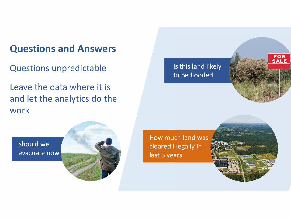
How much land was cleared illegally in last 5 years
Questions and Answers
Questions unpredictable
Leave the data where it is and let the analytics do the work
Is this land likely to be flooded
Should we evacuate now

On-Demand KnowledgeRoad Block 1 – Hardcoded Analytics
How long before the fire reaches my property
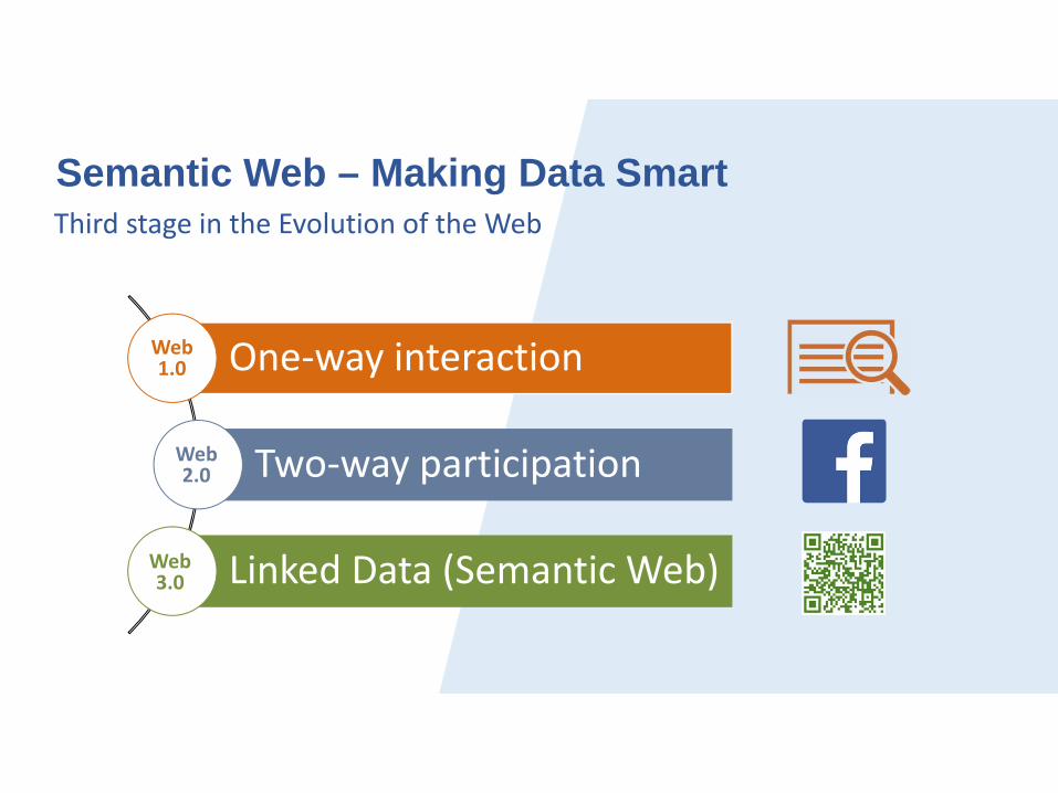
One‐way interaction
Two‐way participation
Linked Data (Semantic Web)
Third stage in the Evolution of the Web
Web1.0
Web2.0
Web3.0
Semantic Web – Making Data Smart

Unprecedented sources of machine‐readable data
Capacity to generate and infer new Knowledge
50 billion IoT devices by 20201
1. https://www.statista.com/topics
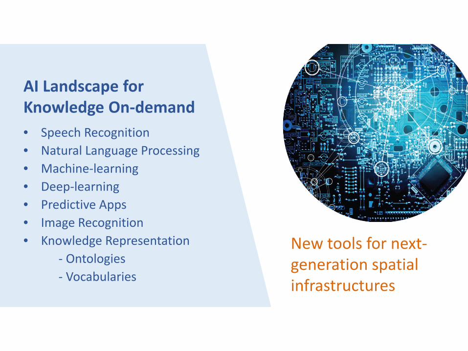
AI Landscape for Knowledge On‐demand• Speech Recognition• Natural Language Processing• Machine‐learning• Deep‐learning• Predictive Apps• Image Recognition• Knowledge Representation
‐ Ontologies‐ Vocabularies
New tools for next‐generation spatial infrastructures

Time consuming manual process
DataProcessQuery
The Traditional Query Process
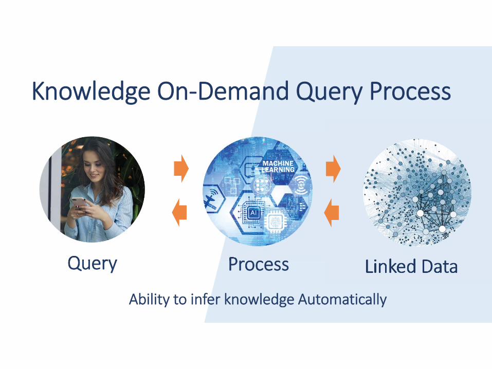
Knowledge On‐Demand Query Process
Linked DataProcessQuery
Ability to infer knowledge Automatically

Government can support innovative query applications by publishing
machine‐readable data
The market will establish new business models

Major Differences
Open Data Portal
Web of Data
Spatial Data Infrastructure
Wiki
OSM
Weather
TrafficLinked Open Data
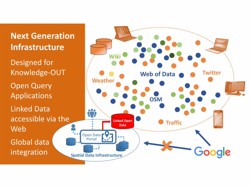
Next Generation Infrastructure
Designed for Knowledge‐OUT
Open Query Applications
Linked Data accessible via the Web
Global data integration
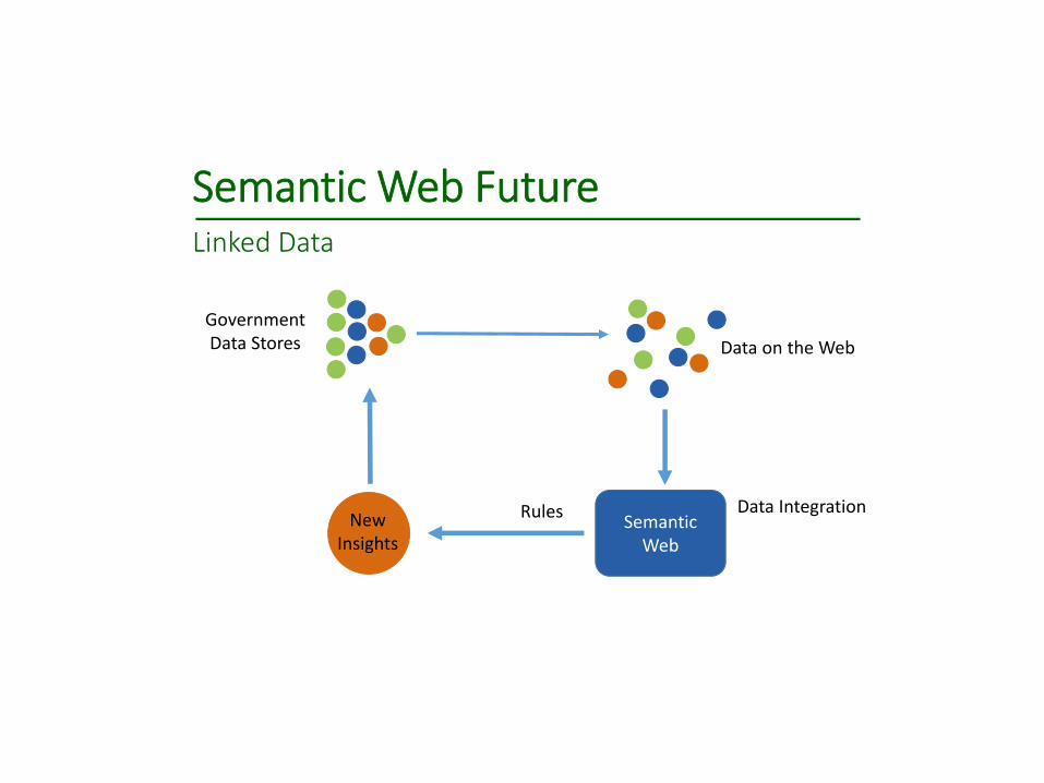
Semantic Web FutureLinked Data
Semantic Web
Data IntegrationNew
Insights
GovernmentData Stores Data on the Web
Rules

Who owns the new insights.
Will inferencing/auto aggregation reveal national
security

Intellectual property rights do not generally apply to facts and “information” per se, but rather the maps, images and
datasets

Data Release ‐ Self descriptive

Digital Rights Management
Lead‐inwithData Request
copy
decrypt and write
Encrypteddata

Knowledge On‐demand requires a rethink and
redesign in the way data and supporting services are
structured(Digital handling)

Next Generation Systems
Answers to questions NOT access to data
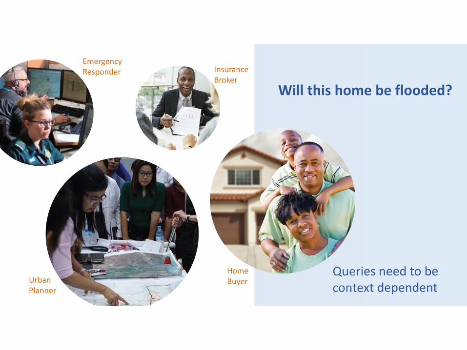
Queries need to be context dependent
Emergency Responder Insurance
Broker
Urban Planner
Home Buyer
Will this home be flooded?

Information Privacy?

Execute the query
Interpret the
question
Retrieve data
resources
Process the query
Portray the
answer
Rank/Rate answers quality
Deliver Answer
Open Query Process
Speech Recognition
NLP, Profiling
SemanticSearch Spatial Filtering
Domain and ProcessOntologies
WMSText, graph, voice, video
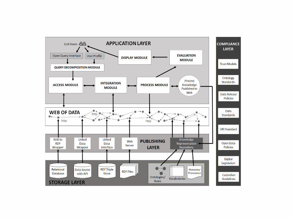
APPLICATION
APP TOOLS
Provenance Trust
Models

Natural Language Processing Used to decompose a human query.Machine learning used to infer meaning
Will my home ever be flooded?
Future Time
Submerged by water
Place/area
Interpret the
question
Retrieve data
resources
Process the query
Portray the
answer
Rank/Rate answer

Semantic Search and Spatial FilteringIdentifies and filters data relevant to a users query and context
Improves simple metadata searches
Will my home ever be flooded?
GPS Coordinateor Address
Flood Risk Map
BuildingFootprint/Land parcel
Interpret the
question
Retrieve data
resources
Process the query
Portray the
answer
Rank/Rate answer

The knowledge to answer a question initially comes from humans.
What, Where, Why, When, and How.
Machines learn from this knowledge.

Domain Ontologies are used to represent knowledge in a particular domain.
They are shareable and reusable.
Home
Person
owns
within
can beBuilding
Address
has
Land Parcel
within
has
Domain Ontologies represent the relationships between concepts
Interpret the
question
Retrieve data
resources
Process the query
Portray the
answer
Rank/Rate answer
has
Need for ontology for data licensing and use

Data Release OntologyUnderstand what elements exist and how they relate
UserDataset
Value LicenceAccess Category
can be accessed by
TypeAction
Open Access
Confidential
Restricted
Not to be Released
Free Cost Recovery
Full‐commercial Freemium
Public Domain
Non‐Commercial(copyrighted)
Commercial View only
Download
Query Citizen
Business
Government
Academia
Rules: Can only have one access category
Price

Data Release OntologyCan Manage Intellectual Property
Usercan be accessed by
TypeAction
Access
Value
Licence
Access
Value
Licence
Access
Value
Licence View only
Download
Query Citizen
Business
Government
Academia
GlobalDataset
AustraliaSri Lanka Vietnam
License
Rules: Creative Commons
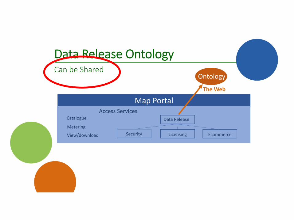
Data Release OntologyCan be Shared
Map Portal
CatalogueAccess Services
SecurityMetering
View/download
Data Release
EcommerceLicensing
Ontology
The Web

Process Ontologies are used to compile, coordinate and run a series of processes to answer a query.
They are shareable and reusable.
Identify data resources
Geo‐reference data
Identify Property
Spatial Intersect with Flood Risk
Zones
Flood Risk Map
Land Parcel
Interpret the
question
Retrieve data
resources
Process the query
Portray the
answer
Rank/Rate answer

Global Geospatial Community Issue – who owns the ontologies
Policies for sharing Knowledge Representation

Ontology Libraries Exist
Developers need not start from scratch

Ontology Libraries Exist
Developers need not start from scratch
There is a need to coordinate these knowledge repositories

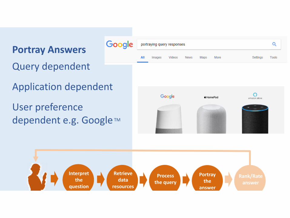
Portray AnswersQuery dependent
Application dependent
User preference dependent e.g. Google TM
Interpret the
question
Retrieve data
resources
Process the query
Portray the
answer
Rank/Rate answer

Who owns the visualisation of a query response
Portray AnswersQuery dependent
Application dependent
User preference dependent e.g. Google TM
Interpret the
question
Retrieve data
resources
Process the query
Portray the
answer
Rank/Rate answer

Ranking according to accuracyRating according to relevanceNo models currently exist for geospatial analytics/queries
Interpret the
question
Retrieve data
resources
Process the query
Portray the
answer
Rank/Rate answer

Provenance

New level for Warrantability
Legal/policy issuesPublishing dataThird party
DRM

Next Generation infrastructure
Designed for Knowledge ‐OUT
Open Query Applications
Linked Data accessible via the Web
Global data integration
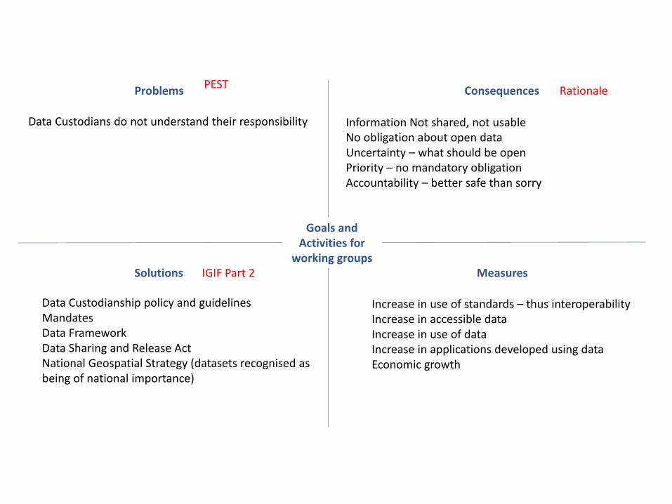
Problems Consequences
Solutions Measures
Goals and Activities for
working groups
Data Custodians do not understand their responsibility Information Not shared, not usableNo obligation about open dataUncertainty – what should be openPriority – no mandatory obligationAccountability – better safe than sorry
Data Custodianship policy and guidelinesMandatesData FrameworkData Sharing and Release ActNational Geospatial Strategy (datasets recognised as being of national importance)
Increase in use of standards – thus interoperabilityIncrease in accessible dataIncrease in use of dataIncrease in applications developed using dataEconomic growth
IGIF Part 2
PEST Rationale

Goals• Legal and Policy Strategic Pathway (Achieving IGIF Goals)
• Establish practise examples, implementation approaches,• Licensing and pricing frameworks• Coherent legal, data and technical infrastructure
• Privacy, Digital Rights Management and Data Security• Data protection laws• Balance access and privacy• Data release classifications
• New Technologies (Risk, new laws, vehicle/phone tracking)• Drones• Digitalisation first choice (linked data?)• Autonomous vehicles• The U.S. government works to minimize human sources of GPS interference through spectrum regulations (domestic and international),
interference detection and mitigation efforts, and law enforcement. • Legislation needs updating re new technologies
• Data Usability (Increase Digital Maturity) (Open data, sharing, standards)• SDGs – integrated geostatistical data
• Legal Interoperability, Collaboration, Multidisciplinary Approaches, Global Networks• Communication tools for policy development but also recognise L & P documents are a tool for communication• Mandates• The part L and P places in sustainable digitisation• Working in a legal and ethical environment• Support innovation• Alignment across Ministries• Policy for Supply chain alignment (Process as well as alignment to government strategy and initiatives)


Benefits of legislative reforms to ensure geospatial programs progress• Improves business competitiveness• Better services for citizens• Supports preparedness and comprehensive security• Maintains and develops efficient administrations• Improve Digital Maturity• Tools for Stakeholder engagement
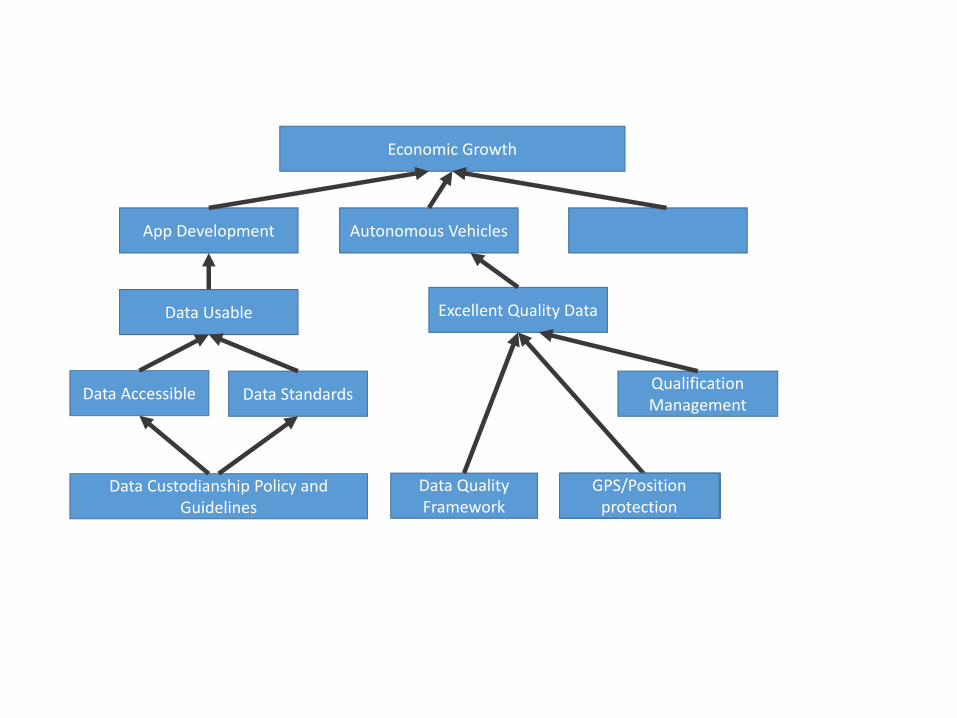
Economic Growth
App Development Autonomous Vehicles
Data Usable
Data Accessible Data Standards
Data Custodianship Policy and Guidelines
Excellent Quality Data
Data Quality Framework
GPS/Position protection
Qualification Management
GPS/Position protection

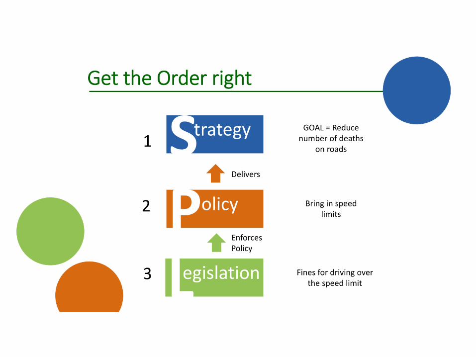
Why Policy Fails!
1
3
2
GOAL = Reduce number of deaths
on roads
Bring in speed limits
Delivers
EnforcesPolicy
Strategy
Policy
Legislation Fines for driving over the speed limit
Get the Order right

Planning
Signage
Communication
Get the Timing rightAllow for Transition
Policy

PolicyCapability
Communication
Get the Timing rightAllow for Transition
Processes

Policy
Communicate How
Guidelines
Procedures
Standards
Tonga
• People. Business, land• Land = social political and environmental connotations• No Survey Act• Climate Change is significant issue• Sufficiently resourced to achieve strategy for sustainable development• Strategy – With National Action Plans• Pacific Geospatial and surveying Council strategy 2017‐2020.• Challenge not to lose momentum• Partners NZ Surveyors (LINZ) and Australia• Building blocks are not there – modern geodetic reference framework