koocanusa reservoir sensitive habitat inventory mapping...
TRANSCRIPT

1
KoocanusaReservoirSensitiveHabitatInventoryMapping–Phase1FinalReportMarch2016
ProjectNumber
UF-F16-110
PreparedFor
FishandWildlifeCompensationProgram
PreparedBy
HeatherLeschied,ProgramManager,withcontentfromBruceMacDonald,fieldteamlead
ReportingPeriod
April1,2015toMarch31,2016PreparedwithfinancialsupportoftheFishandWildlifeCompensationProgramonbehalfofitsprogrampartnersBCHydro,theProvinceofBC,FisheriesandOceansCanada,FirstNationsandpublicstakeholders.
2
ExecutiveSummaryTheEastKootenayIntegratedLakeManagementPartnership(EKILMP)hasworkedtogethersince2006toaddresstheintensificationofshorelinedevelopmentpressuresonlakesintheKootenayRegion.ThePartnershipismadeupoffederal,provincial,regional,municipalandFirstNationsgovernments,communityrepresentativesaswellasnon-governmentorganizations.ThiscollaborativeadoptedFisheriesandOceansCanada'smethodologyforSensitiveHabitatInventoryMapping(SHIM).SHIMhelpstodevelopandimplementguidelinesforshorelinedevelopmentthatprotectsexistingfishandwildlifevaluesandconservesecosystemsandspeciesofconservationconcern.Todate,EKILMPhascompletedprojectsforWindermereLake,ColumbiaLake,WasaLake,MoyieLake,MonroeLake,TieLake,RosenLake,St.Mary’sLake,andJimsmithLake.Thereportscanbeviewedatekilmp.com.In2015,EKILMPinitiatedSensitiveHabitatInventoryMappingprojectsfortheCanadianportionofLakeKoocanusa.ForeshoreInventoryandMapping,andFishandWildlifeHabitatAssessmentwerecompletedduringJulyandSeptember.TheForeshoreInventoryandMapping(FIM)identifiedthelanduse,shoretype,existingripariancondition,andanthropogenicalterationsalongtheforeshoreofLakeKoocanusa.ThefieldteamusedaTrimbleGPSunittomapapproximately160kmofshorelineanddocumentmodifications.Basedonthisdata,theshorelinewasbrokeninto57segments.TheFIMservesasabenchmarkforregulatoryagenciesbydocumentingcurrentforeshoreconditionandstructuressuchasdocksandmooringbuoys.TheFishandWildlifeHabitatAssessmentidentified17samplingsitesspanningavarietyofshoretypes,includinglowrockyshore,sandybeach,cliff/bluff,andcreekmouth.Fish,birdandwildlifehabitatandoccurrenceandaquaticinvertebratepresence/absencedatawascollectedinJulyandSeptembertocapturefishandwildlifevariousbreeding,rearingandmigrationtimeframes.Someobservationsofnoteincluded:thepresenceofjuvenileyellowperchinthereservoir;thehighvaluehabitatandcoldsourcewaterprovidedbythelimitednumberoftributaries;and,theextensiveOffRoadVehicleuseinthedrawdownzone.Criticalnestinghabitatforthelong-billedcurlewwasalsoidentified.Whileprovincialgovernmentagencieshavepreviouslyidentifiedlong-billedcurlewhabitat,andimplementedprotectionmechanismsbydesignatingthelandsasWildlifeHabitatAreas,newnestinglocationswererecentlyidentifiedbytheEastKootenayIntegratedLakeManagementPartnership.

3
ThenextstepforLakeKoocanusawillbetoconductthelow-poolsurvey,andconductthedataassessmenttocompletetheAquaticHabitatIndexandcorrespondingShorelineManagementGuidelinesforLakeKoocanusa.Theindexwillidentifyhabitatvaluesandlevelofriskassociatedwithshorelinemodifications.EKILMPlooksforwardtosharinganddiscussingtheresultswiththelakecommunities,andreceivingfeedback.

4
TableofContents
ExecutiveSummary....................................................................................................................2
Introduction.................................................................................................................................6
GoalsandObjectives..................................................................................................................9
StudyArea.................................................................................................................................10
Methods....................................................................................................................................11
ResultsandOutcomes.............................................................................................................13
Acknowledgements.................................................................................................................14
ConfirmationofFWCPRecognition......................................................................................15
References.................................................................................................................................15
Attachments.............................................................................................................................15

5
ListofFigures
• Figure1:Mapofstudyarea• Figure2:KoocanusaForeshoreInventoryMappingmap
ListofTables
• Table1:LakeKoocanusaPriorityCriteria

6
1. Introduction
KoocanusaLakeisareservoirformedbythecreationoftheLibbyDaminMontanain1973(Figure1).Sincethen,landusepressureshaveescalatedincludingoff-roadvehicleuse,informalcamping,shorelinedisturbance,andwaterqualityconcernsresultingfromupstreamminingactivity.SensitiveHabitatInventoryMapping(SHIM)isaprotocoldevelopedbyFisheriesandOceanCanada.Itprovidesdecision-makers,planners,developers,landownersandgovernmentagencieswiththetoolsrequiredtomakesustainableforeshorelandusedecisionsthattakeintoaccountcumulativeimpactstofishandwildlifehabitats.TheresultingShorelineManagementGuidelinesareusedasaninitialstepwhenreviewing,planningfor,orprescribingalterationsalongtheshoreline.Thisapproachprovidesascience-basedassessmentofareasofhighestnaturalvaluerequiringthehighestlevelofongoingprotection.ShorelineManagementGuidelinescanalsobeusedwhenassessingshorelinepropertyvaluesthroughBCAssessment.ProjectshavebeencompletedforninelakesacrosstheEastKootenay,andareunderwayfortwoadditionallakesintheWestKootenay.Guidelineshavebeenimplementedintolocalplanningpoliciesfortwolakes,andpartnershipcontinuestosupporttheimplementationoftheremainingguidelinesintopolicy.TheSensitiveHabitatInventoryMappingprogramhasthreestages:
1. ForeshoreInventoryMapping(FIM)2. FishandWildlifeHabitatAssessment3. ShorelineManagementGuidelines
FIMassistsinidentifyingthelanduse,shoretype,existingripariancondition,andanthropogenicalterationsalongtheforeshore.Basedonthisdata,theshorelineisbrokenintoanumberofsegments.TheFIMservesasabenchmarkforregulatoryagenciesbydocumentingcurrentforeshorecondition,andprovidesevidenceforregulatoryinvestigationsandwillassessobjectivessetoutinforeshoreprotectioninitiatives.TheFishandWildlifeHabitatAssessmentusesscientificanalysistoidentifyzonesofsensitivityandkeyhabitatfeatures,andrankshorelinesegmentsusingtheAquaticHabitatIndex(AHI).Fish,birdandwildlifehabitatandoccurrenceandaquaticinvertebratepresence/absencedataiscollectedduringthesummerandfalloveraone-yearperiod.TheAHIquantifiestheEcologicalValueforeachshorelinesegmentandidentifiesthepotentialifanthropogenicalterationsweretoberemoved.

7
TheinformationanalysisandresultingShorelineManagementGuidelinesareusedasaninitialstepwhenreviewing,planningfor,orprescribingalterationsalongtheshoreline.Thisapproachprovidesascience-basedassessmentofareasofhighestnaturalvaluerequiringthehighestlevelofon-goingprotection.EKILMPbelievestheGuidelineswillhelpfocuswherenewdevelopmentcouldbelocatedonthelakewhilesustainingpricelessnaturalpublicassetsandmaintainingtheeconomicviabilityofthearea.SHIMhelpsbuildlocalexpertiseandallowscommunitiestotakeamoreactiveroleinplanningandmanagement.DuetooverwhelminginterestfromlakestewardshipgroupsacrosstheEastKootenaytohavetheSHIMprocesscompletedfortheirlakes,EKILMPdevelopedalistofcriteriatobeconsideredapriorityforSHIM.Thisincludes:heavydevelopmentpressures;landuseplanninginplaceorunderway;presenceofamotivatedlocalgroup;cooperativepartnerspresent;sourcewaterissues;and,highfish,wildlifeandarchaeologicalvalues.Koocanusahasbeenidentifiedasthenextprioritylakebythepartnership(seetable1).Lakescompleted:
• LakeWindermere• ColumbiaLake• WasaLake• MoyieLake• MonroeLake
• JimsmithLake• St.MaryLake• RosenLake• TieLake
InrecognitionofthesuccessoftheEastKootenayIntegratedLakeManagementPartnership,asimilarinitiativewascreatedintheWestKootenayin2011,tofocusoninventoryandmappingprojectsforWestKootenaylakes.ThisinitiativeiscalledtheKootenayLakePartnershipandleadingtheinitiativesforthetwoadditionallakes.Lakesunderway:
• KootenayLake• SlocanLake

8
Table1:LakeKoocanusaPriorityCriteriaCriteria LakeKoocanusa
Heavydevelopmentpressure
Highnumberofseasonalvisitorsandday-usersincludingoff-roadvehicleuseandinformalcampingonCrownLand.
Landuseplanninginplaceorunderway.
BaynesLakeOfficialCommunityPlan2011.
SouthCountryZoningandFloodplainManagementBylaw.LakeKoocanusaOfficialCommunityPlan2013.WatershedActionPlanunderway.LakeKoocanusaLand-UseAreaAnalysisunderway.
Presenceofamotivatedlocalgroup.
TheLakeKoocanusaCommunityCouncilhasidentifiedstewardshipofthelakeasapriority.
Cooperativepartnerspresent.
TheRegionalDistrictofEastKootenayandprovincialgovernmentarerepresentedandinvolvedinEKILMP.
Sourcewaterissues.
Erosionpotentialofforeshorecanresultinincreasedsedimentload.Individualdrinkingwatersystemsarelocatedonthelake.
Highfishandwildlifevalues.
Encompassestrans-boundarymigratoryroutesandpartofthePacificFlyway.Surroundinglandsprovidewinterrangeforungulates,habitatforwildlifeandendangeredplantspeciesandprovinciallylistedredandbluemammalsandbirds.Lakeandtributariessupportanabundanceofsportfishandprovidespawning/rearinghabitatsforavarietyofspecies.

9
FishValuesKoocanusacontainsaproductivefisheryforavarietyofspecies,thoughaprimarilypelagicfoodweb.Whilepopulationsofadfluvialsalmonids(bulltroutandkokanee)arerelativelywellstudiedinspawningandrearingstreams,thehabitatuseandshorelineassociationsoftheseandotherspeciesispoorlycharacterizedinKoocanusarelativetootherlargelakesandreservoirsintheKootenayregion.Focalspeciesthatareofconservationconcern,arehighlyexploitedbyrecreationalfisheriesandsignificantfortraditionalusebyFirstNationsincludekokanee,rainbowtrout,cutthroattrout,bulltroutandburbot.BurbotmaybeparticularlysensitivetoshorelinehabitatdisruptioninKoocanusaduetoreservoiroperationsduetospawninghabitatrequirementsandmigratorybehaviour.Spawningandassociatedmigrationsoccurduringthereservoirdrawdownperiodinlatewinter.Itispossiblethatoperationsmaycausedewateringofburbotspawningareasorreductioninsuitabilityofspawninghabitatforfishthatspawninshallowhabitats.Forfishthatascendstreamstospawnorspawninstreamconfluenceareas,operationsmayrestrictaccessorspawningsitesuitability.WhilesomedatahasbeencompiledonfishoccurrenceandabundanceonshorelineareasinKoocanusaandintributaries,theareaislargelydatadeficientandwillrequirefieldsamplingtodeterminespeciesoccurrenceandabundance.Inaddition,shorelinehabitatusemaychangedependingonreservoirelevationatdifferentperiodsoftheyear,andbedynamicallyresponsivetochanginghabitatconditionsasaresultofsedimenttransportandshorelineerosion.Fisheriesvalueswillhavetoaccommodatethedynamicnatureofsuchchanginghabitatconditionsinthereservoir.
WildlifeValuesAnabundanceofimportantwildlifehabitatsurroundsthereservoirandmanyspeciesutilizetheforeshoreforsomeoftheirliferequisites.Fiveungulatespeciesinhabittheareaandseveralthreatenedandendangeredspeciesoccurintheuplandhabitats.Onespeciesofconcern,thelong-billedcurlew,nestsalongtheshorelineofKoocanusa.Unfortunately,onecolonynestswithinthedrawdownzoneandtheirnestsareinundatedeachspringwhenthereservoirlevelincreases.Manyotherspeciessuchascavitynestingducksandraptors,andmammalssuchasgrizzlybeararedependentonshorelineattributesfoundalongtheshoresofthereservoir.
2. GoalsandObjectives
ThegoaloftheLakeKoocanusaSensitiveHabitatInventoryMappingprojectistocompleteacomprehensiveaquaticmonitoringstrategythatwillguideforeshoredevelopmentinamannerthatprotectstheecologicalandculturalhealthofthelake.

10
Theobjectivesoftheprojectare:• Greatlyimproveinformationaboutthefish,wildlifeandarchaeologicalvaluesofLake
Koocanusa;• Developscience-basedcoordinatedmanagementguidanceforlandandwateruses
associatedwithLakeKoocanusa,andpromotetheapplicationofthisguidanceindecision-makingbyalllevelsofgovernmentincludingFirstNations,developers,planners,andallotherinterests;
• Liaisewithrelatedinitiativestoenableaquaticandterrestrialecosystemmonitoringtoeffectivelycontributetoacumulativeeffectsassessmentandanimprovedunderstandingoftheoverallhealthofthelakeecosystem;and,
• Facilitateinformationsharingandencouragescollaborationamongstthecommunitytoefficientlyandeffectivelycoordinateandintegratelandusedecision-making.
3. StudyArea
Figure1:Mapofstudyareaoutlined

11
4. Methods
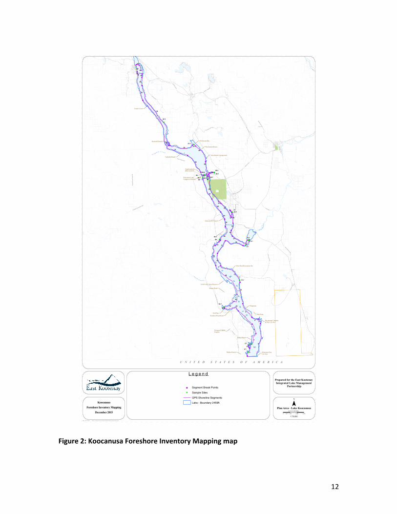
TheForeshoreInventoryandMappingmethodologyisbaseduponmappingstandardsdevelopedforSensitiveHabitatInventoryMapping(SHIM)(MasonandKnight,2001).FieldworkwasconductedduringJuly,2015(atreservoirelevationlevel2,444ft),andSeptember,2015(atreservoirelevationlevel2,459ft).TheForeshoreInventoryandMapping(FIM)identifiedthelanduse,shoretype,substrate,existingripariancondition,andanthropogenicalterationsalongtheforeshoreofLakeKoocanusa.Thefieldteamtravelledthelengthoftheshorelineviahouseboat,andusedaTrimbleGPSunittomapapproximately160kmofshorelineanddocumentmodifications.Basedonthisdata,theshorelinewasbrokeninto57segments(seeFigure2).TheFIMservesasabenchmarkforregulatoryagenciesbydocumentingcurrentforeshorecondition,andprovidesevidenceforregulatoryinvestigationsandwillassessobjectivessetoutinforeshoreprotectioninitiatives.TheFishandWildlifeHabitatAssessmentidentified17samplingsites(seeFigure2)spanningavarietyofshoretypes,includinglowrockyshore,sandybeach,cliff/bluff,andcreekmouth.Fish,birdandwildlifehabitatandoccurrenceandaquaticinvertebratepresence/absencedatawascollectedinJulyandSeptembertocapturefishandwildlifevariousbreeding,rearingandmigrationtimeframes.Fishsamplingwasconductedusingsnorkel,beachseine,andgee-trapprotocols,macro-invertebratesweresampledusingPacificStreamkeepersFederationprotocols,andwildlifesamplingwasconductedusingobservationtechniques.Thefollowingadditionalinformationwascollectedduringfieldsurveys:
• Biophysicalo Shoretypeo Substrateo Percentagenaturalo Aquaticvegetationo Overhangingvegetationo Largewoodydebriso Pocketbeach
• Fisherieso Juvenilerearingo Migrationcorridoro Stagingarea
• Terrestrialo Veterantreeso Snagso Wildlifecorridor
• Modificationso Retainingwallso Dockso Groyneso Boatlauncheso Staircaseso Marinaso Mooringbuoyso Swimmingplatformso Breakwaterso Pillingso Unorganizedcampingo Cattleaccesso Livestockfencingo EvidenceofORVuse
12
Figure2:KoocanusaForeshoreInventoryMappingmap
!
!
!
!
!!
!!
!
!
!
!
!
!
!
!
!
!!
!
!
!!
!
!
!!
!
!
!
!!
!
!
!
!
!
!
!
!
!
!
!
!
!
!
!
!
!
!
!
!
!
!
!
!!
!
6
34
1
25
11
32
2
37
4
3
10
41
30
38
48
23
14
42
45
8
53
13
17
12
29
51
20
19
43
7
50
44
5
18
47
40
28
24
22
35
15
3927
26
33
1646
52
21
49
9
36
31
54
55
56
57
58
!(
!(!(
!(
!(
!(
!(
!( !(
!(!(
!(!(
!(
!(
!(!(
!(
3.1
5.1
4.1
34.1
31.1
28.2
28.1
39.1
39.2
26.140.1
21.1
46.1
11.1
52.1
U N I T E D S T A T E S O F A M E R I C A
La
ke
Koo
ca
nus
a
Madera Ranch Monument DayUse Area
Big springs Campsite& Day Use Area
Big Pines
Flagstone
Sandy Shores
Newgate WildlifeProperty
Sunshine Houseboats
Gold Bay
Strauss Road
Gold Creek Game Reserve
Dorr Road Recreation Site
Oestreich RV Ranch
Koocanusa LakeCampsite & Marina
Yuqakxaqlamki(Boat Launch)
Rockcliff Islands Driftwood Bay
Koocanusa Resort
Ayes Ranch CampgroundUmbrella Beach
E lk
River
P lu m
b o bC r e e k
Go l d
C r e e k
Casey's Cove
15.1
16.1
16.2
Hw
y 93
Hwy 3 And 93
Kikomun-New
gateR
d
Hwy 3
Kikomun R
d
Teepee Creek FSR
Grasm
ere-
DorrRd
Jaffray-Baynes Lake R
d
Colvalli Rd
Wal
do R
d
ShellbornRd
Elko-GrasmereRd
Dorr
Cut-off R
d
BurtonLake
Rd
Kerr Rd
Plum
bob
Cre
ek R
oad
FSR
Cutts Rd
Green
Rd
Suzanne Lake Rd
Fitzpatrick Rd
Smith
Rd
Rosen Lake Rd
Baynes Lake Dump Rd
McMorran Dr
Hwy 3
Lake Koocanusa
Plumbob Creek Road FSR
McMorran Dr
Path: L:\Projects\KoocanusaFIM\MXD\koocanusa_FIM.mxdDate: 08/12/2015
0 1,100 2,200 3,300550
SCALE IN METERS
Koocanusa
Foreshore Inventory Mapping
December 2015Plan Area - Lake Koocanusa
L e g e n d
1:70,000
¯!( Sample Sites
GPS Shoreline Segments
Lake - Boundary 2459ft
! Segment Break Points
Prepared for the East Kootenay Integrated Lake Management
Partnership

13
5. ResultsandOutcomes
TheEastKootenayIntegratedLakeManagementPartnershiphasachievedsignificantsuccesseswithPhase1oftheKoocanusaReservoirSensitiveHabitatInventoryMappingProject.ThepartnershipcompletedtheForeshoreInventoryMappingcomponentandthemid-andhigh-poolsurveysandFishandWildlifeHabitatAssessments.Someobservationsofnoteincluded:thepresenceofjuvenileyellowperchinthereservoir;thehighvaluehabitatandcoldsourcewaterprovidedbythelimitednumberoftributaries;and,theextensiveOffRoadVehicleuseinthedrawdownzone.Criticalnestinghabitatforthelong-billedcurlewwasalsoidentified.Whileprovincialgovernmentagencieshavepreviouslyidentifiedafewparcelsoflong-billedcurlewhabitat,andprotectedthembydesignatingthelandsasWildlifeHabitatAreas,newnestinglocationswererecentlyidentifiedbytheEastKootenayIntegratedLakeManagementPartnership.Long-billedcurlewareBlue-ListedinBritishColumbia,andfederallylistedasaSpeciesofSpecialConcern.Urbanization,forestencroachmentduetofiresuppression,noxiousweeds,conversionofnativegrasslandstoagriculturalcrops,andsoilerosionandrecreationaldisturbancesallthreatentheseshorebirdsthatareprotectedundertheprovincialWildlifeActandfederalMigratoryBirdsConventionAct.BothEKILMPandthecommunitiessurroundingLakeKoocanusahaveanopportunitytofurtherprotectthelong-billedcurlewbyidentifyingthesehabitatsasconservationzoneswithintheShorelineManagementGuidelines.InpartnershipwiththeLakeKoocanusaCommunityCouncil,EKILMPhostedapublicopenhouse,BBQanddialoguewithcommunitymembersduringtheJulyfieldsamplingevent.Approximately25individualsattendedtolearnabouttheprojectandviewmapsofthereservoirprovidedbyEKILMP.Attendeesaskedthoughtfulandpertinentquestionsregardingtheprojectandoutcomes,andalsodiscussedrelevantissuessurroundingthereservoir,suchasOffRoadVehicleuse,reservoirlevelsandtiming,andland-useanddevelopment.Anewsletterwascreatedandcirculatedtothecommunity,andwasalsomadeavailabletocommunitymembersduringthefieldevents.Stopsweremadeatvariouscommunitiestowelcomemembersofthepubliconboardthefieldcrew’sboattotalkaboutissuessurroundingthereservoirandlearnmoreaboutthegoalsandobjectivesoftheSHIMproject.

14
6. Acknowledgements
ThefollowingpartiescarriedoutfieldworkforPhase1oftheproject:BruceMacDonald, FishHabitatBiologist, Fisheries andOceansCanada (retired), TerraLimnicConsultingPeterHolmes,MinistryofForests,LandsandNaturalResourceOperationsHeatherLeschied,EastKootenayIntegratedLakeManagementPartnershipCoordinatorWalterKehler,LakeKoocanusaCommunityCouncilFundingandorinkinddonationsforthisProjectwereprovidedbythefollowingdifferentagenciesorparties:FishandWildlifeCompensationProgramRegionalDistrictofEastKootenayMinistryofForests,LandsandNaturalResourceOperationsWildsightLivingLakesCanadaLakeKoocanusaCommunityCouncilSunshineHouseboatsLtd.
7. References
Mason, B. and R. Knight. 2001. SensitiveHabitat Inventory andMapping. CommunityMappingNetwork,Vancouver,BritishColumbia.315pp+viii.M.Johannes,Editor.
8. ConfirmationofFWCPRecognition
RecognitionofFWCP’ssupporthasbeengivenwhereapplicableincluding:
• KoocanusaSensitiveHabitatInventoryMappingOpenHouse.Newgate,BritishColumbia.July10,2015.
• EastKootenayIntegratedLakeManagementPartnershipSummer2015newsletter.
• “LakeManagementPlanningUsingtheSensitiveHabitatInventoryMappingApproachintheEastKootenayRegionofBritishColumbia”.NorthAmericanLakeManagementSocietyAnnualConference,SaratogaSprings,NewYork.November2015.
15
• “TheStoryofaOnceWildRiver;CollectingDataonLakeKoocanusa”,FisheriesandOceansCanadanewsletter.StreamTalk.Volume23,Number1.Spring2016.
• www.ekilmp.com
Attachments Thefollowingdocumentsareattachedtothisreport:
• StatementofAccountsandsupportingdocuments• FisheriesandOceansCanadaStreamTalknewsletter• EKILMPSummer2015newsletter