l the sea people - australian national university
TRANSCRIPT

i r terra australis 20 l
The Sea People HO I AT I
THE WHITSUNDAY ISLANDS, CENTRAL QUEENSLAND

Pandanus Online Publications, found at the Pandanus Books
web site, presents additional material relating to this book.
www.pandanusbooks.com.au


Terra Australis reports the results of archaeological and related research within the region south and east of Asia,
though mainly Australia, New Guinea and Island Melanesia - lands that remained terra australis incognita to
generations of prehistorians. Its subject is the settlement of the diverse environments in this isolated quarter of the
globe by peoples who have maintained their discrete and traditional ways of life into the recent recorded or
remembered past and at times into the observable present.
Since the beginning of the series, the basic colour on the spine and cover has distinguished the regional
distribution of topics as follows: ochre for Australia, green for New Guinea, red for South-East Asia and blue for the
Pacific Islands. From 2001, issues with a gold spine will include conference proceedings, edited papers and
monographs which in topic or desired format do not fit easily within the original arrangements. All volumes are
numbered within the same series.
List of volumes in Terra Australis Volume 1: Burrill Lake and Currarong: coastal sites in southern New South Wales. R.J. Lampert (1971) Volume 2: 01 Tumbuna: archaeological excavations in the eastern central Highlands, Papua New Guinea. J.P.
White (1972) Volume 3: New Guinea Stone Age Trade: the geography and ecology of traffic in the interior. I. Hughes (1977) Volume 4: Recent Prehistory in Southeast Papua. B. Egloff (1979) Volume 5: The Great Kartan Mystery. R. Lampert (1981) Volume 6: Early Man in North Queensland: art and archaeology in the Laura area. A. Rosenfeld, D. Horton and
J. Winter (1981) Volume 7: The Alligator Rivers: prehistory and ecology in western Arnhem Land. C. Schrire (1982) Volume 8: Hunter Hill, Hunter Island: archaeological investigations of a prehistoric Tasmanian site. S. Bowdler
(1984) Volume 9: Coastal Southwest Tasmania: the prehistory of Louisa Bay and Maatsuyker Island. R. Vanderwal and
D. Horton (1984) Volume 10: The Emergence of Mailu. G. Irwin (1985) Volume 11: Archaeology in Eastern Timar, 1966-67. I. Glover (1986) Volume 12: Early Tongan Prehistory: the Lapita period on Tongatapu and its relationships. J. Poulsen (1987) Volume 13: Coobool Creek. P. Brown (1989) Volume 14: 30,000 Years of Aboriginal Occupation: Kimberley, Northwest Australia. S. O'Connor (1999) Volume 15: Lapita Interaction. G. Summerhayes (2000) Volume 16: The Prehistory of Buka: a stepping stone island in the northern Solomons. S. Wickler (2001) Volume 17: The Archaeology of Lapita Dispersal in Oceania. G.R. Clark, A.J. Anderson and T. Vunidilo (2001) Volume 18: An Archaeology of West Polynesian Prehistory. A. Smith (2002) Volume 19: Phytolith and starch research in the Australian-Pacific-Asian regions: the state of the art.
D. Hart and L. Wallis (2003) Volume 20: The Sea People: late Holocene maritime specialisation in the W hitsunday Islands, central Queensland.
B. Barker (2004)
THE SEA PEOPLE Late Holocene maritime specialisation in
the Whitsunday Islands, central Queensland
Bryce Barker
Editorial team: jack Golson and Sue O'Connor
PANDANUS BOOKS
Research School of Pacific and Asian Studies
THE AUSTRALIAN NATIONAL UNIVERSITY
Cover: Looking south-east from the South Molle Island Aboriginal quarry over Planton Island to Whitsunday Island. Photograph by L. Lamb.
Back cover map: Ho/landia Nova. Thevenot 1663 by courtesy of the National Library of Australia.
Reprinted with permission of the National Library of Australia.
© Publication and format Pandanus Books, 2004.
Published by Pandanus Books in association with the Centre for Archaeological Research and the Department of Archaeology and Natural History, The Australian National University.
Copyright of the text remains with the contributors/authors, 2004. This book is copyright in all countries subscribing to the Berne convention. Apart from any fair dealing for the purpose of private study, research, criticism or review, as permitted under the Copyright Act, no part may be reproduced
by any process without written permission. Inquiries should be made to the publisher.
Typeset in Palatino 10.5pt on 14pt by Pandanus Books and printed by Elect Printing, Canberra .
National Library of Australia Cataloguing-in-Publication entry
Barker, Bryce The Sea People: late Holocene maritime specialisation in the Whitsunday Islands, central Queensland
Bibliography
ISSN 0725-9018
ISBN 1 74076 092 1
1. Archaeology - Queensland - Whitsunday Islands. 2. Aboriginal Australians - Queensland -Whitsunday Islands - Antiquities. I. Australian National University. Research School of Pacific and Asian Studies. II. Title. (Series: Terra Australis; 20).
930.1099436
www .pandanusbooks.com.au
Pandanus Books are distributed by UNIREPS, UNSW, Sydney NSW 2052 Ph 02 9664 0999 Fax 02 9664 5420
Editorial Team: jack Golson and Sue O'Connor
Production: Ian Templeman, Duncan Beard, Justine Molony and Emily Brissenden

Dedication
I dedicate this volume to the contemporary Aboriginal Traditional owners of the region, whose continuing presence and dynamism is testimony to the strength of their culture. It is also hoped that this research will contribute to a greater understanding and respect for the achievements of Aboriginal culture and society within the region and Australia generally.
terra australis 20
vii


Foreword
BRYCE BARKER gained his Honours degree from the Department of Anthropology and Sociology in the University of Queensland in 1987. His Honours thesis focused on a faunal and taphonomic analysis of a newly excavated rock shelter, Narcurrer, located within a limestone sink-hole in south-eastern South Australia, close to the border with south-western Victoria. This project provided him with skills in the analysis of archaeological materials and an interest in issues of socio-cultural and environmental change and particularly their relevance to the mid- to late-Holocene period on the Australian mainland. With these questions in mind, he turned his attention to a new doctoral project centred on the tropical Whitsunday Islands off the central coast of Queensland in 1989. With luck on his side, he soon located and excavated a coastal rock shelter, Nara Inlet 1, situated on Hook Island, which has emerged as the key archaeological site and sequence for the region. This site, which forms the basis of this monograph, provided him with a continuous Holocene coastal sequence going back beyond 9000 years ago and spanning the time when the Whitsunday Islands were disjoined from the mainland by rising sea levels to assume their present form around 7000 years ago. He was now in a position to evaluate questions of change, including their sociocultural and palaeoenvironmental dimensions, throughout this period. Further excavation and analysis of a set of related sites in the islands expanded his data base even further.
World debates surrounding 'change' within hunter-gatherer societies, past and present, became polarised in the 1980s, largely between environmental/biological and socio-cultural schools of thought. This was the case also in regard to Australian prehistory, where emphasis was placed on the primary role of environment, with socio-cultural factors relegated to a secondary place. Hunter-gatherers were constructed largely as 'passive' peoples in contrast to more 'dynamic' horticultural or agricultural societies. Contrasting Aboriginal Australia and its prehistory with that of nearby Papua New Guinea sustained this dichotomy in the Australasian region. In this case, the 'classic' divide between 'hunter' and 'farmer' shaped the core frameworks guiding research. From early on, Papuans seemed to be moving towards 'environmental manipulation' and 'agriculture', while in Australia, 'change' was viewed largely as an adjustment to environmental variations. The result of the world debates that resounded throughout the 1990s and beyond largely transformed our concept of the 'hunter-gatherer'. Today, 'hunter-gatherers' include a very broad range of socio-cultural variation overlapping with horticultural I agricultural peoples and even with traditionally more 'complex' societies. The same could be said of their histories or 'prehistories'. Constructions of ' Aboriginal Australia' and its prehistory have been transformed in a similar way, expanding beyond the constraints of the past (including the colonial past), as is reflected in more recent research. All time periods are being examined in this way, including those of the more distant Pleistocene.
terra australis 20
ix

Bryce Barker's research was guided by and has contributed to questions emerging from these debates. He employs a broad perspective on issues of change throughout a prehistoric sequence spanning more than 9000 years. Also, he considers the emergence of more specialised marine societies on the Whitsunday Islands that more closely resemble the ethnohistorical peoples of the region. These socio-cultural processes were more clearly apparent during the late-Holocene period - the past few thousand years and, in particular, the past 600 years. This monograph, therefore, in many ways is pioneering research of complex issues of prehistoric change.
Bryce Barker obtained his doctorate from the University of Queensland in 1996, which I supervised myself, as I had his prior degree. He is now Senior Lecturer at the University of Southern Queensland and has also taught at the University of Queensland and in the United States of America. Apart from continuing his research on the Whitsundays, he also has had extensive experience in public archaeology, participating in and writing-up numerous projects since he was a graduate student. Also, he has been employed by local Aboriginal communities in Toowoomba as a heritage consultant and continues to work with the indigenous communities in the wider Whitsunday area.
Dr Harry Lourandos School of Social Science University of Queensland
terra australis 20
x
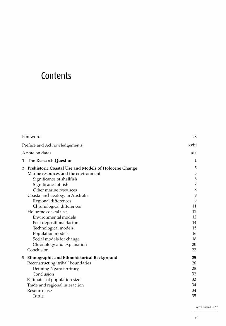
Contents
Foreword
Preface and Acknowledgements
A note on dates
1 The Research Question
2 Prehistoric Coastal Use and Models of Holocene Change
Marine resources and the environment Significance of shellfish Significance of fish Other marine resources
Coastal archaeology in Australia Regional differences Chronological differences
Holocene coastal use Environmental models Post-depositional factors Technological models Population models Social models for change Chronology and explanation
Conclusion
3 Ethnographic and Ethnohistorical Background
Reconstructing 'tribal' boundaries Defining Ngaro territory Conclusion
Estimates of population size Trade and regional interaction Resource use
Turtle
ix
xviii
xix
1 5 5 6 7 8 9 9
11 12 12 14 15 16 18 20 22
25 26 28 32 32 34 34 35
terra australis 20
xi

Du gong 37 Other 37
Canoes and technology 38 Outrigger canoes 38 Bark canoes 39 Discussion 41 Other material culture 42
Other northern coastal observations 42 Discussion 44
4 Palaeoenvironments 45 Palaeoenvironments in northern Australia 46
Palynological evidence 46 Chenier research 47 Other research 48 Discussion 49
Holocene sea levels in northern Australia 49 10,000 bp to 6000 bp 49 6000 bp to the present 52 Discussion 53
5 Field and Laboratory Procedures 55 The survey strategy 55
The surveys 56 The results 56 Discussion 56
Excavation procedures 57 Analysis of cultural material 58
Methods of quantification 58 Shellfish 59 Bone 60 Plant material 62 Land snails 62 Stone artefacts 63
6 Nara Inlet 1, Hook Island 65 Regional description 65 Nara Inlet 1 66
Stratigraphic description 67 Chronology 67 Cultural phases 68
Analysis of cultural material 69 Shellfish 69 Barnacles 75 Fish 75 Crustaceans 77 Marine turtle 79 Other marine fauna 79 Terrestrial fauna 79 Plant material 81 Land snails 82
terra australis 20
xii

Lithic artefacts 82 Non-lithic artefacts 83 Charcoal 85
Discussion 85 Shellfish 86 Fish 86 Turtle and whale 87 Crustaceans 87 Terrestrial fauna 87 Meat weights 88 Stone artefacts 88
Conclusion 89
7 Nara Inlet Art Site, Hook Island 91 Regional description 91 Nara Inlet Art Site 91
Stratigraphic description 93 Chronology 94
Analysis of cultural material 94 Shellfish 94 Barnacles 98 Fish 99 Crustaceans 100 Marine turtle 100 Other marine fauna 101 Terrestrial fauna 101 Plant material 101 Land snails 102 Lithic artefacts 102 Non-lithic artefacts 102 Other cultural material 102 Rock art and ochre 102
Discussion 103
8 Border Island 105 Regional description 105 Border Island 1 105
Stratigraphic description 106 Chronology 107
Analysis of cultural material 109 Shellfish 109 Barnacles 112 Fish 112 Crustaceans 113 Marine turtle 113 Terrestrial fauna 113 Plant material 113 Other cultural material 114 Stone artefacts 114 Other artefacts 114
Discussion 114
terra australis 20
xiii
9 Hill Inlet, Whitsunday Island
Regional description Hill Inlet Rock Shelter 1
Stratigraphic description Chronology
Analysis of cultural material Shellfish Fish Crustaceans Other marine fauna Terrestrial fauna Plant material Land snails Stone artefacts Non-lithic artefacts
Discussion
10 The South Molle Island Quarry
Site description Historical accounts of Aboriginal activity on South Molle Other raw material sources Distribution of black tuff Petrographic analysis Discussion Conclusion
11 The Archaeology: A Synthesis
Timing of occupation Subsistence and economy
The relative importance of dietary resources Changes in subsistence Conclusion
Settlement pattern Technology Conclusion
12 Towards a Prehistory of the Whitsunday Islands
Holocene change and the Whitsunday Islanders Archaeological patterns of change The Whitsunday Islands and models of coastal occupation A model for change in the Whitsunday Islands
Conclusion
References
terra australis 20
xiv
117 117 118 118 119 120 120 123 124 124 124 125 125 125 127 127
131 131 134 135 135 137 138 138
139 139 140 140 143 143 143 145 146
147 147 147 148 150 151
153
List of Figures
1.1 Central Queensland coast: the Whitsunday region, showing excavated sites xx 3.1 Central Queensland coast: the Whitsunday region, showing Ngaro tribal boundary 27 3.2 Central Queensland coast: 'tribal' boundaries 29 4.1 Synthesis of late Pleistocene and early Holocene sea-level data: sea-level curves
for (a) SE Australia and (b) NE Australia 51 4.2 Whitsunday region: coastline at 10,000 BP, -30m contour 54 4.3 Whitsunday region: coastline at 8000 BP, -12m contour 54 6.1 Hook Island 66 6.2 Nara Inlet 1: site map 6.3 Nara Inlet 1: stratigraphic sections 6.4 Nara Inlet 1: sedimentation rates 6.5 Nara Inlet 1: discard rates of shell 6.6 Nara Inlet 1: discard rates of Nerita undata 6.7 Nara Inlet 1: changes in average shell size of Nerita undata 6.8 Nara Inlet 1: discard rates of Manadanta labia 6.9 Nara Inlet 1: discard rates of Lunella cinerea 6.10 Nara Inlet 1: discard rates of Thais kieneri 6.11 Nara Inlet 1: discard rates of Acan thapleura gemmata 6.12 Nara Inlet 1: discard rates of Saccastrea cucullata 6.13 Nara Inlet 1: discard rates of Trichamya hirsuta 6.14 Nara Inlet 1: discard rates of Pinctada fucata 6.15 Nara Inlet 1: discard rates of Melina ephippium 6.16 Nara Inlet 1: discard rates of Asaphis deflarata 6.17 Nara Inlet 1: discard rates of fish bone 6.18 Nara Inlet 1: discard rates of crab shell 6.19 Nara Inlet 1: discard rates of terrestrial bone 6.20 Nara Inlet 1: discard rates of stone artefacts 6.21 Nara Inlet 1: discard rates of charcoal 7.1 Nara Inlet Art Site: site map 7.2 Nara Inlet Art Site: stratigraphic section 8.1 Border Island 1: stratigraphic section 8.2 Border Island 1: discard rates of shell 8.3 Border Island 1: discard rates of Nerita undata 8.4 Border Island 1: discard rates of Manadanta labia 8.5 Border Island 1: discard rates of Lunella cinerea 8.6 Border Island 1: discard rates of Acanthapleura gemmata 8.7 Border Island 1: discard rates of Saccas trea cucullata 8.8 Border Island 1: discard rates of fish bone 8.9 Border Island 1: discard rates of turtle bone 8.10 Border Island 1: discard rates of charcoal 8.11 Border Island 1: discard rates of stone artefacts 9.1 Whitsunday Island 9.2 Hill Inlet Rock Shelter 1: site map 9.3 Hill Inlet Rock Shelter 1: stratigraphic section 9.4 Hill Inlet Rock Shelter 1: distribution of charcoal and burnt bone in
67 68 69 69 70 70 71 71 72 72 74 74 75 75 75 76 78 80 83 85 92 93
107 108 108 108 108 108 109 109 109 109 109 118 119 119
relation to that of fish bone 128 9.5 Hill Inlet Rock Shelter 1: changes in average shell size of Saccastrea cucullata 129 10.1 South Molle Island quarry 133
xv
terra australis 20
10.2 Juan knife 135 10.3 Whitsunday region: distribution of quarry sources and artefact raw materials 136
List of Plates
3. 1 Central Queensland coast: outrigger canoe 38 3.2 Central Queensland coast: three-piece bark canoes 40 3.3 Central Queensland coast: (a) one-piece and (b) three-piece bark canoes 41 6.1 Nara Inlet, Hook Island 66 6.2 Nara Inlet 1 rock shelter 67 6.3 Nara Inlet 1: cut Eretmochelys imbricata shell 6.4 Nara Inlet 1: wooden bipoint 6.5 Nara Inlet 1: cut bivalve shell 6.6 Nara Inlet 1: shell fish-hook blank 6.7 Nara Inlet 1: knotted grass string 7.1 Nara Inlet Art Site: view of excavation 7.2 Nara Inlet Art Site: rock art from main panel 8.1 Border Island 8.2 Border Island: detail of Cateran Bay, location of Border Island 1 8.3 Border Island 1: view of excavation 9 . 1 Hill Inlet, Whitsunday Island 10.1 South Molle Island: view of quarried ridge 10.2 South Molle Island quarry: (a) mined pit; (b) eastern slope of quarry;
(c) flakes and hammerstones; (d) tuff substrate
List of Tables
3. 1 Whitsunday Islands: historical sightings of island occupation 3.2 Central Queensland coast: historical accounts of subsistence activity 3.3 Central Queensland coast: historical accounts of canoe sightings 4. 1 Timing of stillstands relating to specific shorelines across the continental
shelf, central Great Barrier Reef 4.2 Mid- to late Holocene emergence in tropical Queensland 4.3 Mean sea levels between 10,000 BP and 8000 BP in north-eastern Australia 5.1 Whitsunday region: sites recorded, by geographical zone 5.2 Meat weights of modern shellfish 6.1 Nara Inlet 1: radiocarbon dates 6.2 Nara Inlet 1: shellfish data for Nerita undata 6.3 Nara Inlet 1: shellfish data for Monodonta labia 6.4 Nara Inlet 1: shellfish data for Lunella cinerea 6.5 Nara Inlet 1: shellfish data for Thais kieneri 6.6 Nara Inlet 1: shellfish data for Acanthopleura gemmata 6.7 Nara Inlet 1: shellfish data for Saccostrea cucullata 6.8 Nara Inlet 1: shellfish data for Trichomya hirsu ta 6.9 Nara Inlet 1: shellfish data for Pinctada fucata and Melina ephippium 6.10 Nara Inlet 1: stratigraphic distribution of fish families 6.11 Nara Inlet 1: stratigraphic distribution of crabs 6.12 Nara Inlet 1: stratigraphic distribution of terrestrial fauna 6.13 Nara Inlet 1: stratigraphic distribution of edible plants 6. 14 Nara Inlet 1: stratigraphic distribution of non-lithic artefacts 6.15 Nara Inlet 1: total estimated meat weights 7.1 Nara Inlet Art Site: radiocarbon date 7.2 Nara Inlet Art Site: shellfish data for three nerites
terra australis 20
xvi
84 84 84 84 85 92
103 106 106 106 118 132
132
32 36 39
52 53 53 57 60 68 70 71 72 72 73 73 74 75 77 78 81 82 83 88 94 95

7.3 Nara Inlet Art Site: shellfish data for Manadanta labia 95 7.4 Nara Inlet Art Site: shellfish data for Lunella cinerea 96 7.5 Nara Inlet Art Site: shellfish data for Thais kieneri 96 7.6 Nara Inlet Art Site: shellfish data for Acanthapleura gem ma ta 96 7.7 Nara Inlet Art Site: shellfish data for Saccostrea cucullata 97 7.8 Nara Inlet Art Site: shellfish data for Trichomya hirsuta 97 7.9 Nara Inlet Art Site: shellfish data for Geloina coaxans 98 7.10 Nara Inlet Art Site: stratigraphic distribution of shellfish 98 7.11 Nara Inlet Art Site: stratigraphic distribution of other cultural material 99 7.12 Nara Inlet Art Site: stratigraphic distribution of crustaceans 100 7.13 Nara Inlet Art Site: stratigraphic distribution of edible plants 102 8.1 Border Island 1: radiocarbon dates 107 8.2 Border Island 1: shellfish data for three nerites 110 8.3 Border Island 1: shellfish data for Manadan ta labia 110
I 8.4 Border Island 1: shellfish data for Lunella cinerea 111 8.5 Border Island 1: shellfish data for Thais kieneri 111 8.6 Border Island 1: shellfish data for Acanthopleura gemmata 111 8.7 Border Island 1: shellfish data for Saccastrea cucullata 112 8.8 Border Island 1: stratigraphic distribution of fish families 112 9. 1 Hill Inlet Rock Shelter 1: radiocarbon date 119 9.2 Hill Inlet Rock Shelter 1: shellfish data for Nerita undata 120 9.3 Hill Inlet Rock Shelter 1: shellfish data for Monodonta labia 121 9.4 Hill Inlet Rock Shelter 1: shellfish data for Lunella cinerea 121 9.5 Hill Inlet Rock Shelter 1: shellfish data for Thais kieneri 121 9.6 Hill Inlet Rock Shelter 1: shellfish data for Acanthapleura gemmata 122 9.7 Hill Inlet Rock Shelter 1: shellfish data for Saccostrea cucullata 122 9.8 Hill Inlet Rock Shelter 1: shellfish data for Trichomya hirsu ta 122 9.9 Hill Inlet Rock Shelter 1: shellfish data for Geloina coaxans 123 9.10 Hill Inlet Rock Shelter 1: stratigraphic distribution of fish families 123 9.11 Hill Inlet Rock Shelter 1: stratigraphic distribution of crabs 124 9.12 Hill Inlet Rock Shelter 1: stratigraphic distribution of terrestrial fauna 124 9.13 Hill Inlet Rock Shelter 1: stratigraphic distribution of land snails 126 9.14 Hill Inlet Rock Shelter 1: attributes of stone artefacts 126 9.15 Hill Inlet Rock Shelter 1: stratigraphic discard of cultural material 128 10.1 Discard of artefacts of South Molle Island stone at Nara Inlet 1 and Border Island 1 134 10.2 Whitsunday region: geographical distribution of artefact raw materials 136 10.3 Whitsunday region: petrographic description of selected artefacts 137 11 .1 Occupation dates for hinterland sites Townsville to Cape Upstart 140 11 .2 The relative importance of dietary resources at the investigated sites 141 11 .3 The geographical location of sites in the Whitsunday region 144
terra australis 20
xv ii
Preface and Acknowledgements
THIS MONOGRAPH reports research carried out as part of a PhD program in the Department of Anthropology and Sociology, University of Queensland, and is based on the dissertation submitted in 1996. The original thesis has been altered to some degree by collapsing some chapters and omitting others, but no attempt has been made to update the text much beyond the date of its submission. However, tables and graphs have been checked against original schedules, so that the statistical information given here will be the most accurate on record. I thank Emeritus Professor Jack Golson (ANU) for his editorial input and Emily Brissenden (Pandanus Books) for hers in the production process.
During my time in the Department of Anthropology and Sociology, I was fortunate to have Harry Lourandos as my lecturer in my undergraduate years and subsequently as my Honours and PhD supervisor. Harry was the centre of a strong postgraduate culture that was intellectually stimulating and challenging and the presence of this greatly influenced me as undergraduate and postgraduate. In the same context I should like to mention Ian Walters, Ian McNiven and Bruno David, students ahead of me, who helped to shape my view of Australian prehistory in tutorial classes and on the fieldwork they conducted. In addition, I want particularly to thank David Biernoff for his practical support and friendship subsequently at the University of Southern Queensland, without which I might never have finished the present work. I should also like to mention Mike Rowland, who pioneered island archaeology on the tropical Queensland coast and first recognised the research potential of the Whitsunday region.
I should like to acknowledge here the very great debt I owe to the Aboriginal communities in whose country this research took place. Most of my dealings with them were done through the Giru Dala Council of Elders, principally with Irene Butterworth, James Gaston and John Locke. I should especially like to thank the Ngaro peoples, specifically the Butterworth family and especially Irene Butterworth, for their continuing support and interest in this research.
terra australis 20
xv iii

The students who volunteered their time and labour for my research are too many to mention individually, but I single out Debbie Brian, Bruno David, Kathy Frankland, Lara Lamb, Ian McNiven, Kate Quirk and Jim Smith, all of whom contributed substantially to the fieldwork effort.
I should also like to thank the people who willingly gave their time and expertise to various components of the archaeological analysis. They include Dr Steve Van Dyke, Peter Davies, Dr Roly MacKay, Jeff Johnson, Patrick Cooper and Dr John Stanisic, all of the Queensland Museum, and Sinead Melville of the Department of Botany, University of Queensland. Dr M.A. Clements of the Australian National Botanic Gardens, Canberra, provided the information about orchids in Chapter 3. Professor J.M.A. Chappell (Research School of Earth Sciences, ANU) and Emeritus Professor D. Walker (ANU) commented respectively on geomorphological and palaeoecological aspects of Chapter 4, as did Dr Simon Haberle (Research School of Pacific and Asian Studies, ANU) on chronological aspects of the environmental history.
This research would not have been possible without the cooperation of the Queensland National Parks and Wildlife Service based at Airlie Beach. The District and Regional Manager, Arty Jacobson, and his team have been instrumental in promoting a wide range of research endeavours in the Whitsunday region and their commitment to projects that contribute to physical and cultural knowledge of the Whitsunday Islands as a national park was given expression in the professional and practical support they provided. Precise information about site locations is not given, in conformity with the wishes of the Aboriginal community and the Queensland National Parks and Wildlife Service.
Bryce Barker Toowoomba
A note on dates The earlier palaeoenvironmental and archaeological work which I use in this study was reported in terms of uncalibrated radiocarbon dates and when I am citing it I use the lower case 'bp' (= before present = 1950) to indicate this or I mention 'radioncarbon years' in connection with it.
I discuss my own archaeological work in terms of the calibrated values of radiocarbon dates from my four dated sites and use the upper case 'BP' (Before Present = 1950) when doing so, sometimes in the form 'cal BP'.
Since my aim is to look at the archaeological and palaeoenvironmental evidence together, I often talk of both in terms of 'years ago', using for such general purposes an unpublished table giving quick reference to radiocarbon age conversion, drawn up by Simon Haberle of ANU, whom I thank. This table is based on CALIB v3 .1 (Stuiver and Reimer 1993) and takes the midpoint age when different calibrated ages are possible for the same radiocarbon date. CALIB v3 .1 effectively ceases after 19,000 bp, which, of course, is well beyond the period of my immediate interest.
terra australis 20
xix
'.\
V �l>1 I;
'}�y s
[\ ; �\
"·��j � Town.�vil� . � Study area
\i� QUEENSLAND \( Brishanc ;V
(
0 10 20 30 km
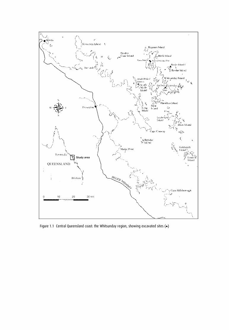
F igure 1 .1 Centra l Queens land coast: the Whitsunday reg ion, showi ng excavated sites (•)
Cioldsmith Island"'
-�NY; /' l.irn.�e� · · Island
The Research Question
THIS MONOGRAPH describes research from the Whitsunday Islands, a group of 73 offshore islands on the central Queensland coast in north-eastern Australia (Fig. 1.1 ). These islands range in size from 0.4 to 10,935 hectares, averaging 333 hectares overall. They are the northern section of the Cumberland Group, a chain of islands which extends from north to south for ea. 200krn.
The work presents evidence of maritime hunter-gatherers from the tropical east coast of Australia. The concept of maritime hunter-gatherers has emerged from research which demonstrates significant differences between some Holocene coastal peoples and huntergatherers who exploit the terrestrial inland. Most of the literature dealing with prehistoric maritime cultures relates to northern hemisphere peoples of the north-west coast, east coast and Arctic regions of the Americas and the coasts of Eurasia, especially Scandinavia and Ja pan (Akazawa 1988; Ames 1985; Braun 1974; Marquardt 1985; McGovern 1985; Renouf 1984; Rowley-Conwy 1983; Sheehan 1985; Yesner 1980). Such literature focuses largely on 'complex fisher-gatherers' of the Holocene, where there is clear evidence of dense populations of sedentary and politically and socially hierarchical peoples living within clearly defined territorial boundaries and closely resembling food-producing societies.
The ethnographic and ethnohistoric evidence from tropical islands and coasts in Queensland clearly indicates a major emphasis on marine resources. The archaeological and historical evidence also points to permanent island-based populations exploiting a coastal fringe with an open-sea hunting subsistence base and little or no access to hinterland resources (Banfield 1908; Barker 199la; Rowland 1983). This system, or systems, is reminiscent of the so-called 'sand-beach' peoples described ethnographically and historically on the east coast of Cape York Peninsula (Chase and Sutton 1987; Hale and Tindale 1933; Thomson 1934, 1956 ). These systems cannot be adequately described in the sense of 'generalised' Australian hunter-gatherers or in terms of models of generalised Australian coastal hunter-gatherers. These coastal people were I are marine hunter-fisher-gatherers, whose marine resources were the basis of their economy and whose country was composed of tracts of sea, reef and mangrove forest. It is in this context that they are best described as 'maritime huntergatherers', hunter-gatherers who derive the major part of their subsistence from the sea. The
terra australis 20
The Sea People
social and cultural systems we are investigating, therefore, are as much social seascapes as social landscapes.
The degree of marine specialisation described in the ethnography and historical records on the tropical north-east coast has seldom been recognised archaeologically. A notable exception to this is Rowland (1982a, 1982b, 1983, 1987, 1989), whose research indicates a highly specialised prehistoric Australian marine-based coastal people occupying the Keppel Islands (see also O'Connor 1992). Indeed, I would argue that, with few exceptions, coastal peoples from the Tropic of Capricorn to Torres Strait relied heavily on marine resources for the greater part of their subsistence needs in a way similar to that described for the Whitsunday Islands and the 'sea-beach' peoples of eastern Cape York Peninsula (see Chapter 3 for discussion). Furthermore, I argue below, based on the results of the case study presented in this monograph, that these specialised systems date largely to the late Holocene, that is, after 3000 BP, and emerged from less specialised but still largely marine-based economies. I also posit that the emergence of highly specialised marine-based settlement I subsistence 'systems' some 3000 years ago in the Whitsundays was related to internally driven social forces, causing a demographic redistribution of populations in the region (see Chapter 12).
The research presented in this monograph arose from a climate of general dissatisfaction with dominant archaeological I anthropological models, which characterised the prehistory of the Australian continent as essentially conservative, static and culturally uniform (Birdsell 1979; Jones 1977b; Maddock 1982; Radcliffe-Brown 1931). Culture change, if it was acknowledged to have occurred at all, was viewed largely in terms of external factors such as environment, technology, biological population increase or outside cultural influences, over which people had little or no control (Beaton 1985; Rowland 1989). A contrast exists, therefore, between simplistic, deterministic archaeological models on the one hand and more complex, holistic anthropological and sociological models of human culture and society on the other. In all, this debate has served to polarise discussion largely between ecologically and socio-culturally oriented approaches, impeding their integration.
In the late 1980s, when the research described in this monograph was initiated, debate in Australia centred on perceived socio-cultural change during the mid- to lateHolocene period. Archaeological evidence for 'change' throughout this period has been observed in all the major biogeographical zones throughout mainland Australia. This evidence takes the form of greatly increased numbers of sites being occupied and greater intensity of site use after the mid- to late-Holocene period, as well as a range of other factors, discussed elsewhere (see Chapter 2) (Attenbrow 1982; Barker 1989a, 199la; Beaton 1985; David 1994; Hall and Hiscock 1988; Hughes and Lampert 1982; Jones 1985; Lourandos 1983, 1985b, 1988; McNiven 1991; Morwood 1987; Ross 1981, 1985; Ross et al. 1992). While this late Holocene trend is generally acknowledged by most archaeologists in Australia (but see Bird and Frankel 1991a), it remains the subject of considerable debate. Generally, most related models in Australian prehistory have so far tended to focus on external forces of change. This is in contrast to Lourandos (1980a, 1980b, 1983, 1985b ), for example, who was one of the first archaeologists to question the largely ecologically based, static models of Australian prehistory. In their stead, Lourandos (1983) proposed a model of dynamic social process effecting regional change during the mid- to late Holocene. These differences in interpretive approach have become what is known as the 'intensification debate' , and its relationship to coastal archaeology in Australia is discussed further below (see Chapter 2).
terra australis 20
2
The Research Question
It was within the framework of this debate that I began looking for a study region in which to address the issue of late-Holocene change in Australian archaeology. My objectives, therefore, were to initiate a regional study investigating mid- to late-Holocene change, in which issues concerned with 'forces of change', as proposed in various models, could be addressed. To this end, it was considered that offshore island systems would provide an appropriate source of data, as most offshore islands are remnants of older mainland coastlines. As such, they promised to reveal long Pleistocene I Holocene sequences which have been subject to marked environmental change, in particular the latest post-glacial marine transgression. Thus, the Whitsunday Islands, a group of large continental islands off the central Queensland coast, were considered to have all the requisites for the proposed research.
The specific aims of this research were: 1) to ascertain if archaeological changes such as have been observed during the mid- to
late Holocene in other parts of Australia were also evident in the Whitsunday region; 2) if this was so, to examine the role of the physical environment in this process of
cultural change, specifically the effects of post-glacial sea-level rises; and 3) to develop a model of change in the Whitsunday Islands which acknowledges the
great complexity of cultural systems and also the role of internal social processes in bringing about change.
terra australis 20
3

Prehistoric Coastal Use and Models of Holocene Change
Marine Resou rces a n d the Env i ro nment
Much of the palynological and archaeological evidence from mangrove sediments and I or archaeological sites in northern Australia shows that macrophytic communities, the richest of marine ecosystems and one vital to the presence of a huge range of sea life, were established in many areas by at least 27,000 bp and that they existed (albeit in different forms, depending on conditions) continuously throughout the Holocene (Crowley et al. 1990; Grindrod 1988; Grindrod and Rhodes 1984; Morse 1988; O'Connor 1989; Woodroffe et al. 1985). Recent archaeological and ecological research relating to coastal systems has also demonstrated the Pleistocene availability and use of marine resources and their continuous viability and resilience in the face of significant environmental change, such as post-glacial sea-level rises and poststabilisation fluctuations (Allen et al. 1988; Barker 1989a; Klein 1979; Mcinnes 1988; Morse 1988; O'Connor 1989).
The zonation and distribution of marine organisms are determined by physical factors such as drying, temperature and solar radiation, and by biological factors such as predation and competition for food and space (Carefoot and Simpson 1985; Connell 1972). Within these parameters two groups of marine organisms may be affected differently. Sessile organisms such as seaweeds, barnacles and some bivalve molluscs must cope with stresses from their established positions. On the other hand, motile organisms such as fish, marine reptiles and mammals, gastropods, amphipods, crabs and starfish have the potential to move into areas when conditions are favourable and out again when conditions are not. Similarly, mangrove ecosystems, essential to a vast array of dependent biota, can grow between specific tidal levels depending on the conditions. For example, long-term variations in sea levels lead to a migration of mangroves to maintain their positions relative to tidal levels. As one species moves out, another more suited to the changed conditions takes over.
In the Holocene marine transgression after the last glacial period, mangrove communities migrated to suitable habitats as the seas advanced, taking up their present distributions only within the past 6000 years bp (Clough 1982; Woodroffe et al. 1985). In their
terra australis 20
5
The Sea People
study of the spatial and temporal distribution of shell middens in relation to estuarine development on the South Alligator River, Arnhem Land, Woodroffe et al. (1988) provide evidence for the early establishment of mangrove species by 7000 bp. They trace various phases of continuous mangrove development throughout the Holocene, despite this period being one of diverse geomorphological change leading to fluctuating resource availability. They conclude that:
[m]angrove forest composition changed by succession from mid tidal mangroves to upper
intertidal mangroves, and subsequently mangroves contracted and freshwater floodplains
became established. Compositional changes [in shellfish species] in middens . . . may be
explained most easily in relation to this mangrove succession . . . (Woodroffe et al. 1988 :102).
Elsewhere, Quinn and Beumer' s (1984) study of a mangrove community on Stradbroke Island has documented the rapid recovery of mangrove ecosystems from almost total destruction. Pioneer species up to 2m tall were firmly established in a four-year period and it is predicted that the communities will have recovered their original composition and size in 15 years. Other studies have shown the ability of some mangrove species to withstand sea-level rises (inundations) of up to 30cm within 140 days (Mclnnes 1988; Odum and Johannes 1975).
Significance of shellfish Much of the debate relating to the reliability, predictability and dietary value of coastal resources has centred on the role of shellfish (Bailey 1975; Buchanan 1988; Cohen 1977; Earlandson 1988; Hayden 1981; Meehan 1977; Osborn 1977; Perlman 1980). In line with Meehan (1977), I propose that the importance of shellfish in coastal economies goes beyond their calorific value and may lie in their reliability and accessibility. I feel the significance of shellfish in the marine subsistence base has been over-emphasised and given an often unwarranted emphasis as a dietary resource because of its high archaeological visibility. For example, Beaton (1985), arguing against the early use of coasts and marine resources, links coastal foraging economies with shellfish. He sees the unpredictability and environmental susceptibility of mud-dwelling bivalve shellfish beds as threatening viable coastal occupation (Beaton 1985:13).
The disproportionate role assigned to shellfish in coastal economies is especially prevalent in the case of open coastal sites. In this context, shellfish demonstrate high visibility, large volume and excellent preservation of shells (but see Anderson and Robins 1988). This is in marked contrast to the small volume and poor post-depositional preservation of many other, and in most cases far more important, marine resources such as fish, crustaceans and other marine invertebrates (Bailey 1975, 1978; Shackleton 1988).
There is little doubt that in most regions shellfish are an important component of social and economic practices, even though they may rarely form a major component of the subsistence base. Meehan' s (1982) classic study of the contemporary use of coastal resources by the Anbarra on the Arnhem Land coast has demonstrated that 'at no time during the year were shell-fish more than a supplementary food in the diet' (Meehan 1982:159), with a maximum energy return of only 17% of the total energy intake. These calculations are very much in line with other estimates made for prehistoric middens in various parts of the world (Bailey 1975; Parmalee and Klippel 1974).
The importance of shellfish in the subsistence base and their attractiveness to coastal hunter-gatherers are illustrated by the following statements from Meehan.
terra australis 20
6

Prehistoric Coastal Use and Models of Holocene Change
In general, shell gathering required no special physical strength nor skill, nor the expenditure of
much energy. In this respect it was unlike other foraging pursuits carried out by the serious
women such as goanna catching or yam digging, both of which were considerably more
demanding (1977:524) .
The actual time devoted to the gathering of shellfish on any one day was small - about two
hours, depending on the state of the tide. During that short time a skilled woman could collect
shellfish equivalent to about 2000 kcal (1977:524) .
Shellfish was one of the dependable food sources in Anbara [ sic] diet (1977:526).
They were there for the taking, like food on a supermarket shelf . . . (1977:526).
Meehan' s (1977, 1982) research has been crucial for the development of coastal archaeology in Australia, for it highlights the fact that resources may be important for more than their quantitative (e.g., calorific) contribution to Aboriginal life. In particular, her study demonstrated the susceptibility of bivalve shellfish beds to destruction by adverse environmental conditions and discussed the adaptive strategies employed when a major part of an important shellfish resource was wiped out by a cyclonic event. She states that:
when the normal supply of open-sea shellfish was unavailable to the Anbarra . . . they turned
their attention to another combination of foods, which, from all accounts, provided a
satisfactory diet (Meehan 1982: 163).
She also points out that the Anbarra were confident that the shellfish beds would eventually be replenished. 'After all, they said, similar events had occurred before and the shellfish had re-colonised the area' (Meehan 1982:164).
It is clear that a range of complex factors such as coastal geomorphology, the type of shellfish exploited, quantities available, resource selection and cultural decision were major influences in the role of shellfish in coastal economies in different parts of Australia through time. The prograded coastal flats of Arnhem Land, where Meehan' s studies were undertaken, tend to be rich in large beds of bivalve species and especially vulnerable to seasonal environmental and climatic fluctuations. Under different circumstances, however, coastal resources may be less affected. The Whitsunday Islands, for example, possess a shellfish faunal suite that is dominated by non-sessile rock-platform gastropods, whose habitats are less susceptible to short-term climatic fluctuations. The habitats themselves tend to be more generalised and extensive. Consequently, the shellfish beds themselves tend to be more resilient in the face of fluctuating conditions. As Meehan (1977) has argued before me, this positions shellfish as a relatively reliable resource base in the broader subsistence economy. In this context, the importance of shellfish in the Whitsunday Islanders' diet lay in its reliability and predictability as an easily obtainable, densely packed resource in the face of fluctuating environmental conditions.
Furthermore, the species favoured in the Whitsunday s were those that were most easily obtained, and not necessarily the larger species which would provide, in themselves, a much greater return of energy. For example, a range of large mud-dwelling bivalves such as Gelo11ia coaxans are present archaeologically, but only in very low quantities, despite evidence that suitable habitats for these species were in place (see Chapters 6-11). This, I would argue, is a result of cultural selection rather than availability, indicating the position of such resources in the broader cultural landscape.
Significance of fish As with northern hemisphere coastal peoples, fish were probably more important in the subsistence economy of Aboriginal coastal peoples in Australian prehistory than were
terra australis 20
7
The Sea People
shellfish. This is despite the acknowledged problems associated with the under-representation of fish in Australian archaeological sites. These problems relate to post-depositional site destruction processes, inadequate excavation controls (large sieve mesh sizes) and rules of behaviour regarding the disposal of fish bones, which have all militated against the preservation of fish remains in archaeological deposits (McNiven 1991; Nolan 1986; Walters 1979; d. Casteel 1976; Colley 1986). For example, in the Gulf of Carpenteria, the Gungalidda 'sea-beach' people systematically threw fish bones on to the fire because the sharp, needle-like bone was dangerous if left lying in the sand around the camp. The reason for burning fish bones was explicitly acknowledged by the Gungalidda elders with whom we camped and indeed was pointed out to us during our stay (personal observation 1988).
It is possible that a similar process of site management may have resulted in the underrepresentation of fish bones from archaeological sites in many parts of Australia, including rock shelters where habitable space is circumscribed. Thus, our previous understanding of the role of some coastal resources like fish in broader economic systems may be somewhat biased.
The importance of fish in the subsistence base is significant to our understanding of marine productivity in the region. Fish is a highly diverse (existing in a range of habitats) and abundant motile resource, which is particularly resilient in the face of major environmental events, including the post-glacial sea-level rise. Unlike the highly predictable fish resources found in some northern temperate coastal zones, however, the fish resource in the tropics, while probably always relatively abundant, was essentially a patchy resource with no guarantees regarding predictability or abundance, thus encouraging relatively high degrees of mobility (O'Connor 1992).
Other marine resources From the historical and ethnographic accounts it is clear that the coastal peoples on the east coast of Australia north of the Tropic of Capricorn relied heavily on marine resources, including fish and large marine mammals and reptiles (see Chapter 4). Turtle and dugong are recorded historically and ethnographically as being the most important foods for tropical coastal groups on the north-east coast of Australia (Moore 1979; Thomson 1934:241). Although evidence of these species is found in archaeological sites, it is usually scanty. Because of the obvious under-representation of individuals in archaeological sites, I feel that the combined meat weights of large marine mammals and reptiles probably far exceed any other marine resource. A huge range of essentially archaeologically invisible vertebrate and non-vertebrate species such as rays, mangrove worms and sea slugs would also have been available.
In summary, I would argue that interpretations and models of coastal occupation based on the relationship between marine resource availability and environmental factors such as sea-level change or climatic fluctuations place too great an emphasis on the primacy of environment in affecting resources, human responses to change and thus the archaeological pattern of coastal occupation. In many instances, the tone of argument in regard to these issues has a distinct environmentally deterministic emphasis. These general concerns will be explored more fully below.
tcrra australis 20
8

Prehistoric Coastal Use and Models of Holocene Change
Coasta l Archaeo logy i n Austra l ia
Regional differences During the past 50 years or so of 'modern' archaeology in Australia, there has been a clear emphasis on excavation of coastal sites. This is due to a range of factors, neatly summed up by Bowdler, who states that:
Most of our universities and other centres of research are closer to the coast than not, and hence
most of the researchers are too. Most modern industrial-residential development is closer to the
coast than not, hence more accidental discoveries are made there, and more mitigation-salvage
work is required (Bowdler 1982:vi) .
Until the mid-1970s, most of this coastal research was carried out in the south-eastern part of the continent, in New South Wales, Victoria and Tasmania (Bowdler 1970, 1971, 1976; Coutts 1967, 1970; Gill 1955; Jones 1966; Lampert 1966, 1971; McBryde 1974; Megaw 1965). Syntheses of this work generally portray coastal occupation and use as seasonal. Poiner (1976), for example, surveying data from 11 sites on the central and south coast of NSW, argues that coastal resources are least abundant during the cold, wet winters in temperate environments, thus forcing people to disperse into the hinterland. In support of her model, she uses evidence of summer seasonality in the form of the presence of the summer-migrating mutton-bird (Puffinus tenu irostris ) in rock shelters such as Durras North (Lampert 1966) and Curracurrang (Megaw 1965), as well as ethnohistoric data. Later work in the temperate regions of Australia supports a coastal/hinterland seasonal model. Lourandos (1980b) identified coastal base camps (Seal Point) where people utilised a wide range of coastal resources in the summer, including seal, shellfish and fish, with a dispersal into hinterland regions in the winter. Coastal/hinterland seasonal occupation is also posited for much of Tasmania (Jones 1971; Vanderwal 1978).
Further to the north, in northern NSW and south-east Queensland, some seasonal movement between coast and hinterland is documented, although this is seen to be less clearly defined (Draper 1978; Lilley 1978). For example, Coleman (1982:2) proposes as an alternative model to seasonal coastal/hinterland movement one of 'relatively very large numbers of people living in relatively very small territories or ranges, gaining their subsistence entirely from the maritime zone, the coastal plain and the estuaries'.
Whatever the degree of seasonality in coastal occupation, it seems clear that coastal habitation in the temperate south-east of Australia was less specialised than that of the tropical north, with a greater dependence on a terrestrial resource component and shore-based marine resources (cf. Barker 1991a; O'Connor 1992; Rowland 1982a). This pattern of south-eastern occupation could be summarised as lacking an open-sea exploitation strategy, with an emphasis on estuarine exploitation, seasonal use of islands and hinterland areas. This shorebased occupation of the littoral is evident in many of the temperate coastal archaeological sites, judging from the relatively high terrestrial resource component in the subsistence base. For example, at Rocky Cape (Jones 1978), meat weights from terrestrial species calculate to approximately 18% of total meat weights at the site. There is also a significant terrestrial component at Seal Point (Lourandos 1980b), Currarong (Lampert 1971) and Cave Bay Cave (Bowdler 1984).
Research in the subtropical coastal regions between Moreton Bay and Fraser Island in the south-east of Queensland has generally shown a greater emphasis on marine subsistence, with relatively large semi-sedentary groups exploiting the rich and easily accessible Moreton Bay islands, at least in the late Holocene. Subsistence was 'based on marine [mainly fish and
terra aus tralis 20
9
The Sea People
shellfish] and littoral resources' (Hall and Hiscock 1988:8; see also Frankland 1990; Hall 1982; Hall and Lilley 1987; McNiven 1985, 1990; Morwood 1987; Nolan 1986; Walters 1987). It is apparent, however, that a hinterland component to settlement and subsistence was also in place (cf. Draper 1978; Lilley 1978; see also Collier and Hobson 1987).
Coastal archaeology north of the Tropic of Capricorn (at Rockhampton on the Queensland coast) has highlighted some differences in coastal use from that in the south. Rowland's (1982a) research on the Keppel Islands clearly demonstrates a permanent mid- to late-Holocene island population that was highly specialised in a maritime fisher-gatherer subsistence mode. There is no hinterland/ terrestrial component apparent and only minimal exploitation of terrestrial resources. Rowland (1982a:118) says that this specialised marine adaptation may have been part of a general adaptation related to island use in the southern Great Barrier Reef.
O'Connor states that the difference in the settlement and subsistence pattern between the south-eastern Australian islands and those of the tropical north can 'probably be best explained by the nature of the resource base' (O'Connor 1992:57). She observes that the tropics have few seasonal or densely clustered resources and that while tropical environments are resource-rich, the resources are highly mobile, patchy and non-seasonal. Implicit in her model is that permanent island occupation is a product of the nature of the resource base. There is evidence, however, for non-permanen t occupation of tropical island systems, from the early- to late-Holocene period in the Whitsunday region, and also in the late Holocene in the Northumberland Group of islands off the central Queensland coast. These examples, which are discussed elsewhere, indicate regular non-permanent visitation which may be seasonal (Andrew Border, Department of Environment and Heritage, pers. comm.; also see Chapter 3).
In summary, coastal models employed in Australian archaeology generally relate to seasonal coastal / hinterland movements, in which people mainly occupied the coast on a seasonal basis (Coleman 1982; Lourandos 1980a, 1980b; Poiner 1976; Vanderwal and Horton 1984). In such models, coast-based and relatively sedentary coastal peoples were also hinterland peoples, their degree of coastal specialisation being more or less defined by their seasonal movement away from the hinterland (Collier and Hobson 1987; Hall and Hiscock 1988; Hallam 1987; Jones 1971). Thus Hallam (1987:10), who says:
[m]uch emphasis has been put on the role of literally littoral resources - fish or shell-fish . . .
but these rarely provide as much as 50% of the diet even of those Aboriginal groups who are
regarded as predominantly coastal . . .
Under these circumstances, coastal use was seen largely as the terrestrially based exploitation of the littoral resource, that is, the shore-based exploitation of marine resources by terrestrial peoples. In these accounts, specialised marine technologies are rarely (if ever) considered, lending further weight to the terrestrial focus of so-called marine systems. Discussion on coastal resource use in this context invariably focuses on either shellfish or fish (Bowdler 1977; Hall and Bowen 1989; McDonald 1992; McNiven 1991; Walters 1987) and archaeological sites tend to lack the diversity and range of marine fauna expected of a maritime economy.
Such coastal models can now be identified as being more applicable to the southern temperate and subtropical part of the continent, with coastal exploitation in the northern tropics exhibiting a range of quite different maritime adaptations (see Barker 1991a; O'Connor 1992; Rowland 1982a). These coastal, as distinct from littoral, adaptations include higher population densities, less mobility and a greater degree of maritime specialisation.
terra australis 20
1 0
Prehistoric Coastal Use and Models of Holocene Change
Chronological differences In the Australian region, coastal resources have been documented at archaeological sites approaching and exceeding 30,000 years bp in age: in northern Australia at Mandu Mandu Creek shelter at North West Cape, WA (Morse 1988:84, 87, 25,000 ± 250 bp) and Koolan Island, west Kimberly (O'Connor 1989:102, 27,300 ± 1100 bp) and in the Bismarck Archipelago of Papua New Guinea at Matenkupkum cave, New Ireland (Allen et al. 1989:550-1, 557-8, basal dates ranging from 31,350 ± 550 bp to 33,300 ± 950 bp). Just how important coastal/marine resources were, and to what extent they may have been important to later developments, will probably never be fully known, because there is little doubt that coastal archaeological sites are highly susceptible to post-depositional destruction. This is due not only to the dynamic nature of coastal geomorphology, but most notably to the post-glacial sea-level rise (Bird 1992; Rowland 1992). Thus, nearly all the Pleistocene coastal sites found to date occur in rock shelters located along steep and rocky shorelines that were close to the Pleistocene coast. Their survival on present-day terrestrial shores is due to the fact that they were protected from inundation and other related, post-depositional site destruction processes.
The known Pleistocene coastal sites in Australia, therefore, must represent but a tiny fraction of the actual number of sites occupied in the past. Thus they are certainly a poor reflection of the real extent of systems of past use. Ethnographic studies of contemporary coastal hunter-gatherers in tropical Australia, for example, show that a preferred living space was out in the open, just up from the high-water mark, and that rock shelters were occupied only during periods of the wet season (December-February ) (Chase and Sutton 1 987; Moore 1979) . Despite these limitations, there is nevertheless clear evidence of long and con tinuou s use of marine resources in Australian prehistory and equally clear evidence of an increase in the use of coastal resources and greater maritime specialisation during the Holocene (Barker 1989a, 1991a).
Models of prehistoric coastal use in Australia have been shaped largely by continental colonisation models, in which it is generally agreed that the first people to enter Australia must have done so by island-hopping (Birdsell 1977; Bowdler 1977) . Indeed, Bowdler (1 977) shaped the broad configuration of Aboriginal prehistory around a coastal colonisation model and structured her arguments around the premise that the first immigrants in Australia were already coastally adapted and would thus have been familiar with a broad range of tropical littoral resources once they reached the Australian coast. The dispersal of peoples, therefore, would most likely have been along the familiar coastlines and their hinterland fringes, moving up the rich, well-watered major river systems into the interior. Perhaps not insignificantly, this is also the pattern of invasion that took place with the arrival of Europeans some 40,000 years later.
Although Bowdler' s model lacked the archaeological evidence for a uniquely coastal Pleistocene occupation (explained as a product of the drowning of the Sunda coast after the last glacial maximum), it was supported by evidence of early and extensive inland lacustrine occupation, accessed from the coast, at Lake Mungo. Additionally, there is support from a range of young dates for the occupation of the interior of the continent. Although a number of much earlier Pleistocene dates have now been established in arid and semi-arid zones of the interior (e.g. David 1991, 1993; Smith 1988), those at the arid core of Australia are still substantially younger than those in the tropical north, Tasmania or the Willandra Lakes.
The more recent research on coastal occupation that has provided evidence of latePleistocene coastal use back to 30,000 years bp and more suggests a generalised low-density exploitation of the littoral throughout the Pleistocene, in line with some models of Pleistocene settlement and subsistence in Australia (e.g. Lourandos 1987; but see also O'Connor et al. 1993).
terra australis 20
1 1
The Sea People
Ho locene Coasta l Use
Holocene models of prehistoric Australian coastal occupation have tended to focus on the apparent late-Holocene occupation of coasts and islands. Of the hundreds of dated coastal sites in Australia, 90% are post-mid-Holocene, with the majority of them dating to within the past 3000 years. Except for the evidence of two sites in the Whitsunday Islands, Nara Inlet 1 (Chapter 6) and Border Island 1 (Chapter 8), all island use considerably post-dates the arrival of the sea at its present level (see Barker 1989a, 1991a). For example, Hughes and Lampert (1982), in a review of 24 coastal sites on the south coast of NSW, show that 70.9% of them date from the mid- to late Holocene and that in the past 5000 years the increase in the number of sites showing evidence of occupation is roughly two- to three-fold (Hughes and Lampert 1982:20). Similarly, Hall and Hiscock (1988) in research in the Moreton Bay region show that 89.4% of all coastal sites occur from the mid- to late Holocene. The pattern of a late Holocene increase in sites and in intensity of site use is not restricted to the coastal margin, but is found generally over the continent (Lourandos 1985b ).
With the exception of Lourandos (1980a, 1980b 1983, 1984, 1985a, 1985b, 1987, 1988; cf. Barker 1991a; David 1994; McNiven 1991; Williams 1987, 1988), who explains late-Holocene change within a socially oriented theoretical framework, most of the explanations for this pattern are based on techno-environmental or prime-mover I single-cause explanations. These relate to such factors as the effects of sea-level change on coastal resources and on human populations (Beaton 1985; Hughes and Lampert 1982; Walters 1989); the lack of a suitable technology to exploit maritime resources (Beaton 1985; Sullivan 1982; Vanderwal 1978); preservation factors affecting survival of earlier sites (Bird 1992; Godfrey 1989; Rowland 1989); population increase forcing the use of hitherto marginal coastal environments (Beaton 1985; Hall and Hiscock 1988; Hughes and Lampert 1982); and even a refutation that a mid- to lateHolocene pattern of change exists at all (Bird and Frankel 1991a, 1991b).
These models are discussed in some detail below and subsequently tested in light of the archaeological evidence from the Whitsunday region (see Chapter 12).
Environmental models For Rowland, one of the most consistent advocates of environmental processes acting as agents of change in coastal archaeology in Australia, the proliferation of coastal sites around Australia is explained in terms of responses to the potential role of environmental factors, which altered the range of alternatives available to Aboriginal populations in the mid- to late Holocene (1983:63). Rowland's model, although incorporating a range of environmental factors, focuses especially on the effects of sea-level fluctuations after stabilisation around 6000 bp or 7000 years ago.
Since there is evidence of climatic fluctuations and variations in sea-levels [around 3500 and 2000
radiocarbon years ago] both on a global and regional basis, it is worth incorporating these factors
in a working model of adaptation and change in the Holocene of Australia (Rowland 1983:71 ) .
The basic tenets of this model are based largely on the given that late-Holocene climatic and sea-level change had a significant effect on marine resources and that the pattern of late-Holocene coastal sites is a product of adaptive responses to these changes.
Similarly, Beaton' s model of coastal occupation at Princess Charlotte Bay (north-east Queensland) focused on 'when and under what circumstances the intertidal and estuarine environments of Australia became important in the occupation of Australia' (1985:1). Beaton argues that coastal economies were only ever important in Australia in the late Holocene and that the late-Holocene archaeological signature of coastal occupation is a real reflection of the
terra nustralis 20
1 2

Prehistoric Coastal Use and Models of Holocene Change
use of the littoral. He invokes the negative effects of sea-level change on marine resources to explain an apparent lag between the timing of sea-level stabilisation and human occupation in the region. A combination of 'newly available' coastal resources and increasing population pressures saw the establishment of marine economies, as reflected in the archaeological record, after 3000 years ago (Beaton 1985), that is, some thousands of years after sea-level stabilisation (cf. Beaton 1985:18) at around 7000 years ago. To the south, Walters (1989:220) has similarly argued for the late-Holocene coastal occupation of Moreton Bay, stating that there was a delay of some 4000 years in the appearance of evidence of fishing after the formation of the modern bay.
These models of coastal occupation are based largely on a number of common assumptions in Australian coastal archaeology. These are summarised as follows: 1) that the post-glacial marine transgression had a negative effect on marine resources
and human populations; 2) that shellfish were a major part of the marine economy of coastal peoples (i.e. that
marine resources are largely shellfish-based); and 3) that change as found in the archaeological record invariably equates to environmental
change. Beaton's (1985) and Rowland's (1983) models are dependent on assuming that
changes in sea level (post-glacial marine transgressions or post-stabilisation fluctuations) and I or the relatively minor climatic fluctuations of the late Holocene (compared with environmental changes in the early Holocene) affected marine resources to the extent that the pattern of human exploitation of coasts was altered.
It is clear that the effects of sea-level change are invariably seen as being crucial to our understanding of the human use of coasts. Archaeologists casting around for an environmental explanation to fit the late human adaptation to coasts have seized upon sea level as an obvious correlate for late-Holocene coastal occupation. I argue that what is needed is not just a simple linking of apparently contemporaneous events but a detailed study of the relationship between marine ecosystems and environmental change.
While there is no question that climatic and sea-level change did have some impact on the range, presence and density of certain marine species during the post-glacial period, I argue from the ecological and archaeological evidence that marine resources are either largely unaffected (motile organ isms) or are effected only in the short-term (sessile organisms) . The motile species (fish, marine reptiles and mammals, various marine invertebrates) are generally ubiquitous, resilient, quick to re-establish and not necessarily dependent on sealevel stabilisation or periods of stillstand. Furthermore, I argue that motile marine organisms, that is, those less likely to be affected by sea-level change, are a far more important marine resource than sessile organisms. The latter, especially mud-dwelling bivalve shellfish dependent on shoreline progradation for a habitat, are probably more susceptible to environmental factors. Additionally, I argue that shellfish, although generally most likely to be affected, are in any case a relatively minor marine resource in Aboriginal coastal economies.
The dynamic and ever-changing nature of coastal environments is a commonly stated feature of coastal studies and is seen as a natural process of dynamic coastal geomorphology. This is due largely to cyclical phenomena such as cyclonic events, fluctuations in precipitation and changes in tidal ranges. It is not surprising, therefore, that many marine organisms are well-equipped to deal with short- and long-term change to their ecosystems and that human populations living on coasts had strategies in place to cope with events that they, or someone within living memory, had experienced before. Furthermore, I believe it is unlikely that the documented environmental changes of the mid- to late Holocene were of an order that would significantly effect coastal resources in one of the richest, most varied and resilient of ecosystems (see Chapter 4).
terra australis 20
13

The Sea People
In a global review of known Holocene environmental changes, Rowland (1983) lists a disparate range of environmental variables which he states may effect change as found in the archaeological record. These include changes to precipitation; changes in temperature by one degree Celsius; departures from normal weather conditions recorded since the 1930s (closely correlated with changes in degrees of windiness and an 80-year cycle in sunspot activity, resulting in morphological changes in so-called 'sensitive areas' such as sand fields, deserts and mountains); the important interactive role of temporal and spatial ice variations with climate; and secular variations in geomagnetic declination responsible for changes in atmosphere circulation and hence climate.
Even if Holocene sea-level and climatic changes were relatively small scale and local by
comparison with those of the Pleistocene they may nevertheless have had very significant
effects on Aboriginal population distribution and adaptation (Rowland 1983:70-1) .
In contrast, I would argue that there is not a significant correlation between environmental change and change as found in the archaeological record. It is not denied that changes in environmental conditions rnay have stimulated social change, within the context of specific pre-existing social conditions (cf. Dwyer and Minnegal 1992). It is, however, the nature of pre-existing social conditions that must be addressed, because the effect of environmental changes on social phenomena will depend on them.
In effect, environmental changes were greatest between the last glacial maximum, ending around 18,000 bp or some 21,000 years ago, and the early Holocene. The most significant and wide-ranging changes in sea level, oceanic and ambient temperatures, precipitation, vegetation and climatic pattern had occurred by 7000 years ago. Although there is a slight trend towards drier conditions towards the latter third of the Holocene, far greater environmental changes had taken place before this time. The archaeological changes of around 3000 years ago, therefore, occurred at a time of relative environmental stability and thus cannot be easily correlated with environmental change.
While I agree that it is essential to document changes to local environments through time and that these are part of the contexts influencing human behaviour, being some of the continuing factors that people consider when making decisions, I would also argue that the role of the environment is over-emphasised and too often given undue primacy in affecting social and cultural change. Models which automatically invoke environmental changes to explain all forms of social or culture change have largely failed to investigate the effects of these changes on the human resource base in any detail. I would argue that it is more valuable to examine whether, for example, a change in temperature of 1°C or a decrease in precipitation actually have an effect on marine biota and marine resources, rather than simply assuming this as fact. When examined closely, it is clear that marine ecosystems, especially in the tropics, are extremely resilient, diverse and adaptable to a wide range of environmental conditions.
Post-depositional factors Other largely environmentally driven coastal models in Australia have sought to explain the late-Holocene archaeological coastal pattern as a product of site preservation factors. Such factors include coastal erosion, cyclonic activity and higher sea levels after 6000 bp (ea. 7000 BP) (Godfrey 1989; Head 1983, 1986; O'Connor and Sullivan 1994; Rowland 1989). For example, Head (1986:126) says:
terra australis 20
14
[ a ]n artificial synchroneity may have been given to an archaeological record that i s itself partly
an artefact of environmental processes, obscuring the variability in space and time which is
probably closer to the real picture.

Prehistoric Coastal Use and Models of Holocene Change
Implicit in these statements is a non-cultural explanation for the distinct late Holocene coastal archaeological signature. They also imply that what has variously been interpreted as evidence of late-Holocene intensification or population increase is an erroneous artefact of nature, being based on an incomplete or truncated archaeological record.
It has been well documented that taphonomic site formation processes have had a marked effect on the survival of open coastal sites, especially in the tropics (see Bailey 1983; Bird 1992; Godfrey 1989; Rowland 1992). There is, however, also clear evidence, especially from coastal rock shelters, where such post-depositional processes have less effect, that the major archaeological changes evident in the late Holocene are not a product of differential preservation (Barker 1989a, 1991a). Although not presented here, the evidence for major changes in settlement, subsistence and technological practices after 3000 BP in northern Australia is unequivocal (see Chapter 12). This, coupled with a lack of significant environmental change at this time, clearly implies that a late-Holocene increase in numbers of coastal archaeological sites may be largely a cultural phenomenon (Barker 1989a, 1991a, 1993; Lourandos 1983, 1985b; see also McNiven 1991). Furthermore, the well-documented evidence for increases in numbers of occupied sites in non-coastal areas, and the increase in intensities of site use during the late Holocene in so many regions (e.g. David 1994; Jones 1985; Lourandos 1983, 1985b, 1988; McNiven 1988; Morwood 1987; Ross 1981, 1985; Ross et al. 1992; Smith 1988), cannot simply be neglected in any explanation which attempts to link the phenomenon on the coast with site preservation factors. Much of this evidence comes from rock shelters largely free of large-scale post-depositional problems. I will discuss this issue in regard to the archaeological evidence from the Whitsunday region in Chapter 11.
Technological models Rather than give primacy to environmental causation, some models have looked to technological factors to explain archaeological changes. In particular, technological innovations are deemed to have increased the 'efficiency' (however defined) of existing systems, thereby justifying their adoption. However, motivations behind the initial emergence or invention of new traits are rarely addressed. This is especially the case with regard to the occupation of islands.
Talking about NSW, Sullivan (1 982:16) suggests that '[m]oves to island exploitation . . . may reflect an increase in sophistication of technology. It is possible that canoes improved after line fishing rendered their use essential '. Jones ( 1977 a:325-9) invokes the shortcomings of canoe technology as a limiting factor in offshore exploitation in Tasmania and south-eastern Australia. Vanderwal (1978:121-2) proposes that offshore islands were able to be exploited only once canoes had been developed sometime during the late Holocene.
Technological models see diffusions along the coast as explaining the late-Holocene emergence of specialised maritime systems in north-eastern Australia. Thus Beaton (1985:18) says that '[t]he use of the islands [at Princess Charlotte Bay] . . . probably had to await the introduction of the outrigger canoe of Papua-Melanesian origin', while Rowland (1987:39) believes that 'there is strong support for the view that external cultural influences affected a large area of the Queensland coast and this factor needs to be considered in explanations of change' .
Recent research, however, on offshore islands in north-western Australia has established that a permanent island population with a marine economy was in place around 3000 BP and that the people involved lacked a specialised marine technology.
Surprisingly, this extreme reliance on maritime resources does not appear to be reflected in the
material culture or technology of the region's inhabitants. Watercraft used in the area
comprised simple rafts . . . Fish hooks and nets were unknown (O'Connor 1992:51 ) .
15
terra aus tralis 20
The Sea People
Although it may well be the case that in the late Holocene a specialised marine technology was introduced on the eastern Queensland coast from Torres Strait, its emergence could equally be explained as a localised response to an increased dependence on local marine resources (see Chapters 11 and 12). Within this context, the emergence of new technologies can be seen as developing in response to perceived local needs. The fact that the pattern of intensive maritime occupation after 3000 BP occurred, in at least one area, without use of a specialised marine technology and quite free of any external influences (O'Connor 1992) supports the notion that such technologies are (or are not) utilised in response to localised resource requirements and that they are not a universal prerequisite for intensive coastal I island occupation. The failure to develop canoes to a sophisticated level in Tasmania, thereby hindering island use, says more about the relative importance of islands in the economy than about the ability to develop a seagoing canoe technology. In the protected waters of the Kimberley, where islands were important, sophisticated watercraft were not a requirement for intensive island use and were never developed.
Population models Models of population increase are also invoked to explain the appearance of coastal sites during the late Holocene (Beaton 1985; Hall and Hiscock 1988; Hughes and Lampert 1982; Sullivan 1982). For example, Hall and Hiscock (1988:14) suggest that in Moreton Bay a sparse population abandoned the coast in the face of the last marine transgression and reoccupied the newly formed offshore islands after 2500 bp because 'slow intrinsic population increase since 6000 [radiocarbon years] BP may have begun to put pressure on food resources' .
Beaton (1985) states that population growth in Australia was slow and largely unchanging until the late Holocene, after which populations greatly increased. This forced a largely terrestrially based population into a greater reliance on marine resources, culminating in more or less specialised coastal systems. Sullivan (1982) links the occupation of offshore islands on the NSW coast with population increases on the mainland, while Hughes and Lampert (1982) also suggest that increases in the intensity of occupation on the southern NSW coast can be explained by population increase. In their view, this may have initiated increased marine exploitation and increased extractive efficiency, the latter explaining the observed changes in stone tools.
At first glance, the above frameworks may appear to be reasonable explanations for the archaeological pattern of coastal occupation in Australia, particularly the late-Holocene proliferation and intensification in use of sites. Possible archaeological indicators for population increase, such as the more intensive use of existing sites, increases in numbers of sites occupied and the range of habitats utilised, as well as increased degrees of specialisation, are certainly all evident from the archaeological record. Nevertheless, this pattern could just as easily be interpreted as reflecting other factors, such as demographic or social reorganisation, rather than simple population increase.
The major shortcomings of many population models like those above are their failure either to provide any explanation for the increase or a simplistic attribution of primacy to single-factor causes such as technology or environmental change, while ignoring social factors, which by definition are implicated in change.
Factors affecting population growth are complex and not easily inferred from the archaeological record. Reference to unsupported notions of 'intrinsic' population increase in attempting to explain the late-Holocene archaeological pattern is not useful in eliciting the stimulus for population growth (Beaton 1990; Hall and Hiscock 1988; see also McNiven 1991). For example, Beaton (1990) and Hall and Hiscock (1988) ask us to accept, as a given, that population growth is inherent to biological populations, in the light of which the whole issue of 'why' populations increased is deemed irrelevant.
terra nustralis 20
1 6
Prehistoric Coastal Use and Models of Holocene Change
In the case of all biological populations, and therefore in the case of all human populations . . .
and therefore in the case of Australian Aboriginal populations of the past, we need no further
explanation for their growth. They simply have that biological capacity, and we should expect
growth of population as the general rule . . . (Beaton 1990:27-8) .
However, while Beaton says that populations will grow until such time as existing social and economic strategies are restrained by environmental conditions, he provides a population growth model curve which favours a long period of stasis with no exponential increase over time, despite optimum conditions for greater carrying capacity, until the mid- to late Holocene, which saw rapid growth of the population base. This model fails to make clear why there were 35,000 to 40,000 years of population stasis (given the biological determinism of the model) before any increase occurred in the late Holocene. It does not even allow for an exponential increase over time, as it is said that 'populations with very near stationary growth rates will eventually grow quite spectacularly' (Beaton 1990:27). Beaton (1990:36) is forced to invoke a crude environmental explanation for stasis in such populations: 'They are continually at the mercy of potential stochastic environmental and demographic disasters, and are barely able, in general, to outbreed their mortality rate.'
The fact that populations of humans were successfully occupying most, if not all, biogeographical zones in Australia by at least 35,000 BP shows, I would argue, con tra Beaton (1990) and others (e.g. Hall and Hiscock 1988), that Pleistocene populations were highly successful in adapting to a wide range of environmental extremes.
Nearly all research on human demographic patterns stresses the importance of cultural factors and the inter-relationship between cultural changes and demographic changes (Cowgill 1975a, 1975b; Dumond 1975; Harris 1977; Hassan 1978; Spooner 1972; Ward and Weiss 1976). Ward and Weiss, for example, see marked change in the social structure of human populations as affecting three main areas of demographic concern. These are the extent to which population growth is regulated and by what mechanisms; the density, spatial distribution and degree of aggregation of individuals; and the distribution of vital rate schedules (fecundity, death rates and so forth) as a function of socio-cultural practices.
Speaking of the Palaeolithic, Hassan (1978:72) says:
it would be . . . absurd to infer that the human populations were recklessly uncontrolled,
repeatedly overpopulating their habitat, to be reduced in number by starvation and death . . .
such a view is inconsistent with ethnographic observations of hunting-gathering and
agricultural populations. Population growth during the Pleistocene was most likely regulated
by cultural procedures.
However, inherent biological population growth that results in over-population remains a common ecological explanation for change. I would agree with Cowgill, who convincingly argues (1975a:514) that:
[ o ]n the whole, it seems as if development is more likely to be stimulated by the prospect of
new opportunities, rather than the threat of hardships. At least in some broad way it is
intensification of demand, rather than intensification of stress . . . that most effectively generates
development.
In Cowgill's view, this demand, which favours population increase, encompasses a complex set of variables including technology, environment and, importantly, economic and political variables. Examples of these demands include the conversion of surplus resources into prestige, status or authority. This rests on accumulation and redistribution, either of food or of other things acquired through food or other primary resources. Cowgill goes on to say (1975a:516) that:
terra australis 20
1 7
The Sea People
[r]ather than seeing population growth as an inherent tendency of human populations which is
permitted by technological innovations, [he looks on] population growth as a human possibility
which is encouraged by certain institutional, as well as technological or environmental
circumstances, but equally may be discouraged by other circumstances.
I would argue that this crucial social ingredient is missing from the essentially environmentally inspired population models discussed above and that population increases, such as may have occurred in the late Holocene, for example, were closely linked to a wider set of changes. In line with Lourandos (1983:81 ), I suggest that modifications in social and cultural systems occurred at this time throughout much of Australia, resulting 'in increases in the complexity of social relations and economic growth, sedentism and, by inference, population sizes' (see Chapter 12).
Social models for change Lourandos' influential social model of late-Holocene 'intensification' is one of the few which attempts to provide a sophisticated and more integrated approach to Aboriginal prehistory in Australia. As Lourandos (1983:81 ) puts it,
Socially-oriented approaches tend to view transformations within cultures or societies as to some
extent socially promoted . . . [arguing] that reactions to stimuli or influences are culturally filtered,
that is, based upon a range of choices. The social dynamics or relations at any given time would
influence the direction of such changes and thus in relation to economy, the level of production.
Focusing on archaeological research in south-west Victoria, where a consistent pattern of mid- to late-Holocene initial site occupation and/ or intensification of site use is apparent, Lourandos has explained this pattern as a product of dynamic social relations which placed demands on the economy and production. This model is outlined below.
Lourandos has convincingly argued that archaeological changes can be identified from the archaeological record of many parts of Australia, with a particularly strong and widespread period of change during the mid- to late Holocene. Unlike his predecessors, he argues that these changes are caused by a reorganisation of social relations, which resulted in ever-increasing demands on the economy and production. In turn, these processes of intensification brought about, as he puts it, increases in the complexity of social relations, in economic growth, in sedentism and in population sizes (Lourandos 1983:81 ).
The model sees more complex kinship networks developing between local groups as a result of the need to ensure sustainable levels of reciprocity, whereby a system of economic and socially delayed return is established. This relationship of reciprocity ensures access to a wider network of resources and services, considered especially important in marginal environmental areas during times of stress or abundance. Hence, while social in nature, Lourandos' model incorporates a consideration of ecological circumstance. Crucially, however, and unlike previous social models (e.g. Yengoyan 1976), the latter cannot be said to have predetermined the direction, intensity or timing of social change. Rather, Lourandos argues that kinship relationships, especially exogamous marriages, were a key to extending the system to a wider alliance system or social network. Inequalities in power, prestige and status developed within and between groups and individuals as vested interests extended territorial area through extended kinship relationships. For men, this allowed greater access to, among other factors, the acquisition of multiple wives, thus increasing the economic and socio-political power of individuals. Over time these relationships become increasingly complex, placing further demands on the economy: '[p]roductivity and production are in this way affected for incentives exist (due to the dynamic nature of the social relations) for their manipulation' (Lour an dos 1 983:90 ) .
tcrra australis 20
18
Prehistoric Coastal Use and Models of Holocene Change
These increasingly competitive and complex inter-group relations demanded a forum for economic and social distribution, which took the form of regular 'ceremonial events and gatherings, inter-tribal meetings and trading occasions' (Lourandos 1983:90). These occasions, which involved the congregation of large numbers of people over sustained periods of time, had to be financed over and above the normal subsistence requirements of individuals in smaller-scale social units. This placed considerable demand on production, resulting in the need to intensify the resource base. As Lourandos (1983:91) puts it,
the intensification of social relations and ceremonial and inter-group activity in an increasingly
competitive direction would have resulted in further increase to productivity and production.
The exploitation of new resources and new resource areas and the development of perhaps
more efficient extractive methods and strategies may have thus been promoted, for incentives for
change arose out of the nature of the social relations. Changes to settlement-pattern involving
increased levels of sedentism may have been part of this process (Lourandos 1983:91 ).
This model was based on the considerable anthropological literature relating to Australian Aboriginal social organisation. In this forum, political and social inequalities have been shown to be appropriate mechanisms for social change, articulating internal social conflicts and contradictions (Godelier 1975; Hamilton 1980; Hart and Pilling 1960; Keen 1989; Kolig 1989; Myers 1982; Sutton and Rigsby 1982; Williams 1982; Yengoyan 1976).
Drawing on a number of studies (Anderson 1984; Bailey 1969; Nicholas 1968; Sutton 1978; Sutton and Rigsby 1982; von Sturmer 1978), Keen (1989:23) provides a description of this process, which is centred on leadership in Aboriginal society.
Aboriginal leaders are represented as entrepreneurs, able to manipulate rules and resources in
order to achieve status and to accumulate control of key resources .
. . . Among the general category of older men, and sometimes older women, leaders with
influence of varying scope are described as including 'camp bosses', ' field bosses', and 'big
men' . Each was the focal member of a clan and of a residence group, and in some cases, a
regional network. The leader was regarded as a repository of knowledge over which he (or she)
had control, and passed on to younger people. The leader was feared because of believed access
to supernatural forces which that knowledge, as well as control of ceremonies, implies. Leaders
had control over various formal procedures: they directed, controlled, organised and made
decisions in regard to ceremonies. They had the power to remove taboos, and to 'punish'
offenders. A leader was seen as the means of access to resources, and in this way 'worked for '
and 'nurtured' his followers. As senior land owner, the leader appeared to be the source of
land-based resources, as well as religious knowledge and wives for his sons. Competition is
reported both among leaders, and among groups of leaders with their supporters. Leaders
competed in some way for a following, and groups competed for control of land and ritual .
While the studies in question clearly record the social framework in which change may occur, they lack a temporal perspective in which the inequalities may eventually, although not necessarily, manifest themselves in changes to society and culture. Furthermore, it could be said that established social strategies, including social structures, have in-built mechanisms of flexibility and resistivity to deal with social stress. Consequently, major change will only rarely occur when stress thresholds are broken. Most commonly, the nature of change will be such that it will occur in the context of established social strategies. It may, therefore, not depart significantly from prior strategies and more often than not will not be archaeologically visible. On the other hand, when major changes occur, they are likely to result in a radical restructuring of many aspects of the existing social system over a short period of time and therefore have the potential to be visible in the archaeological record.
terra australis 20
1 9
The Sea People
Chronology and explanation Lourandos' model of Holocene social change in south-eastern Australia is dependent on a perceived trend of significant archaeological change. In a series of recent papers, however, Bird and Frankel (1991a, 1991b; see also Frankel 1988) have attempted to 'deconstruct' the notion of late-Holocene change, archaeological and social, by questioning not only the use of social process as an explanatory tool, but the very existence of the purported late-Holocene archaeological changes themselves. They argue that late-Holocene developments in southwestern Victoria are just the latest in a continuous series, all of them seen as a result of environmental change, and they do not require the special explanation of 'intensification'.
It is common practice in Australia to assume continuous occupation (i.e. regular use) of sites
with changes in the quantity of discard seen as showing varying intensity of occupation . . .
Even where radiocarbon dates thousands of years apart are separated by as little as 20 cm of
sediment continuity of site-use is assumed . . . Excavated sequences may be divided into
chronological units of thousands of years duration . . . [This] denies us the possibility of
demonstrating significant variation in site-use, and assumes that an 'averaged' discard pattern
resulting from innumerable occupation episodes over enormously long periods is a valid
measure (Bird and Frankel 1991a :l81 ) .
Clearly what needs to be clarified here is the term 'continuity of site use'. Con tinuous use does not necessarily mean regular use; no assumption should be made about regular visitation. It could be that 100 years separates one visit from another and 50 years separates the next. The important point is that if people seem to be using a given site in similar ways when they visit, and exploiting the same sets of resources with similar technologies, 'continuity of site use' can be said to exist.
Bird and Frankel (1991a:181) also imply that change, as observed in the Australian archaeological record, is measured largely by perceived increases in discard rates of cultural material. This assumption can be effectively discredited with the use of virtually any qualitative data, including my own. For example, the advent of a whole new set of stone artefact types during the mid-Holocene (e.g., bondi points, geometric microliths, pirri points and so forth) implies qualitative technological changes, not just quantitative ones. Numerous other examples of such change will come to light as I present the results of my excavations in the Whitsunday Islands (see Chapters 6-11 ). In light of these data, the presence of quantitative and qualitative change cannot be denied. Nor can it be attributed solely to environmental change in a single-cause explanatory manner.
Despite efforts to demonstrate that there is no increase in the establishment of late-Holocene site use, Bird and Frankel end up strongly confirming such a pattern:
all excavated [shelter] sites appear to have been used during the last millennium, although this
observation may be partly the product of method. Thus while there may have been a late
prehistoric increase in shelter-use . . . (1991a :186, my emphasis);
the number of dated middens certainly increases through time (1991a :186);
[m]ounds appear only in the last 2,500 years ( 1991a :187).
Their suggestion (1991a:186) that the late-prehistoric increase in shelter use to which they admit above may ' owe more to local [i.e. , site specific] relationships to available resources at different times than to broad underlying trends in settlement pattern' is unconvincing, given the scale and relative uniformity of the observed change in shelter use in a very broad set of environments, ranging far beyond the region in question (Attenbrow 1982; Hughes and Lampert 1982; Lourandos 1987).
terra australis 20
20
Prehistoric Coastal Use and Models of Holocene Change
Bird and Frankel (1991a:188) find no evidence for late-Holocene 'developments in alliance networks, productivity and settlement pattern as signatures of a process of increasing social complexity or intensification'. This assertion implies that there is no pattern of increased site use in the late Holocene and no increase in the range and rates of use of resources as found archaeologically. I would argue that this view is clearly erroneous, as the pattern of lateHolocene cultural change is one of the strongest in Australian archaeology. The pattern and its indices are clearly documented in nearly every biogeographical area in Australia (e.g. Beaton 1985; David 1991; Flood 1980; Hall and Hiscock 1988; Hughes and Lampert 1982; Luebbers 1978; McNiven 1991; Ross 1985; Rowland 1982a; Smith 1988; Veth 1989).
Similar archaeological indices of change have been employed in other chronological contexts in Australia and the wider region, including the late Pleistocene. Examples of this include comparisons between south-western and south-eastern Tasmanian sites of that period (Cosgrove et al. 1990); a comparison of sites in sectors of north-western, central coast and south-western Western Australia (O'Connor et al. 1993); Colless Creek in north-western Queensland (Hiscock 1988); Fern Cave in north-eastern Queensland (David 1991; Lamb 1993); and Pleistocene coastal sites on offshore islands of New Guinea such as New Britain and New Ireland (Allen et al. 1988; Enright and Gosden 1992).
Furthermore, the indices of change used in Australian archaeology are similar to those used to quantify change in other parts of the world. For example, in the Upper Palaeolithic of south-western Europe, the following are all used generally as indices of change between the earlier (Aurignacian, Perigordian and Solutrean) and later (Magdalenian) periods of the Upper Palaeolithic: increases in numbers of sites occupied; an increase in the area occupied within sites; increases in the number of species and quantity of resources exploited; and technological changes (Bahn 1983; Gamble 1986; Mellars 1973; Sonneville-Bordes 1973; White 1982).
Finally, Bird and Frankel (199lb:5-6) imply that the late-Holocene archaeological signature is a product of non-cultural factors of preservation, specifically of an environmentally dynamic coast, and unsuitable for addressing factors of cultural change.
Middens are also particularly susceptible to the effects of weathering and erosion . . . The
likelihood of a substantially higher sea level at about 3000 [radiocarbon years] BP . . . would
also, obviously, have a serious impact on the survival of earlier sites. Factors such as these may
account for the absence of earlier midden dates . . . [T]he relative paucity of earlier dates may
also be a product of a systematic research bias toward better preserved (younger) sites.
Given these problems the apparent increase in midden numbers must be regarded with caution.
Although some coastlines may not be suitable for the investigation of late-Holocene patterns of change given their dynamic environmental contexts, it is clear from the archaeological evidence from many parts of Australia, including south-western Victoria, that the late-Holocene pattern of coastal use, in which the overwhelming majority of midden sites post-date 3000 BP, is also evident in rock shelters not subject to the same taphonomic processes as open sites (Beaton 1985:5; Hughes and Lampert 1982; Lourandos 1997). I would thus argue that in order to elucidate change regarding the use of coasts, appropriate coastal situations should be sought. Such situations would include steep shorelines unlikely to have been subject to coastal inundation, but where the seaboard has remained in close proximity over long periods of time. One such setting, at Nara Inlet 1, is the subject of attention in this monograph (see Chapter 6 ).
terra australis 20
2 1
The Sea People
Conc l us ion
The models outlined above attempt to provide explanations for change in which, almost without exception, single-cause 'prime-mover' catalysts are posited. I feel that these models show a general lack of understanding of the processes of change in human culture and society. There can be no simple explanation for why structural change occurs, nor are there any universal laws for change. Each situation develops in response to a unique set of circumstances particular to a point in time, a region, a social system or individuals within systems (cf. Dwyer and Minnegal 1992).
Keesing and Keesing (1971:351) discuss how the process of change may be initiated, arguing that different individuals have different perceptions ('mental maps') of the 'rules' of social life. The latter are often not verbalised but remain implicit, and thus each individual learns a partly unique version of their culture. Therefore, any society contains a reservoir of diversity in cultural codes which con tinually sets up alternatives and potentially contradictory principles and rules. Individuals may choose to exploit these alternatives in order to provide opportunities for themselves, despite (or perhaps because of) the potential social contradictions this may cause.
If we are to assume that all cultures are continuously changing - that they are dynamic - how is it possible to talk of change as an 'event' that can be quantified in terms of the archaeological record? If change is continuous, then surely the archaeological record, in its turn, is one that documents continuous and uninterrupted periods of change. However, of the huge numbers of changes occurring every day, executed by individuals, societies or cultures, very few will have any long-term or material impact on society, and even fewer will be of an order of scale that will leave any archaeological signature. Because of the gross nature of the archaeological record, identifying the scale of change is crucial, and it is reasonable to state that mainly large-scale changes to culture, society or environment will register archaeologically.
Many archaeological studies rely on stylistic differences in material culture to investigate social or cultural change. These include changes in pottery styles, mortuary practices, architecture or stone tool types (Clarke 1968; Hodder 1982, 1987; Plog 1974). In Australia, however, changes to the material component of society over time are relatively few. When present, they are either archaeologically invisible (e.g. body scarification) or difficult to assess temporally (e.g. rock art, fish-traps, ceremonial grounds). I would argue that this factor has contributed significantly to the portrayal of prehistoric Aboriginal cultures as static and unchanging.
I would suggest that the strongest indicators of change in the Australian archaeological record may be linked to economic productivity and settlement and subsistence systems. When considered as such, these characteristics demonstrate trends of change during the late Holocene that are repeated throughout most of Australia. Such patterns of temporal change after the mid-Holocene are characterised by among other things an intensification of regional site use, the exploitation of new environments such as islands and the exploitation of new sets of resources, as well as by a range of associated qualitative changes (David 1991; Lourandos 1980a, 1983; Ross 1985; Smith 1988; Williams 1987), Bird and Frankel (1991a, 1991b) notwithstanding.
This pattern can be seen as reflecting an intensification of local, regional and interregional social relations. This is evident from a range of other studies, in Australia and internationally, in which the above indices are considered important components of social models of change in hunter-gatherer studies. For example, Bender (1985) argues that resource intensification during the Late Archaic of the American mid-continent, including the widening of the resource base and more intensive use of existing sites (i.e., increased sedentism), was
terra australis 20
22
Prehistoric Coastal Use and Models of Holocene Change
due, among other factors, to social demands on production or to social processes that encouraged longer-term aggregation and greater productivity.
It is thus my intention in this monograph to utilise the following indices to identify change through time in the archaeological record: increases in discard rates of all cultural material; increases in the number of resources utilised; increases in the number of sites established; technological change; evidence of initial use of previously unutilised local environments; and, as an indicator of greater 'intensity of site use', evidence of predation pressure on specific resources. If found to exist, such change will be examined in the light of the models outlined above. Thus the relationship between change as found in the archaeological record and such factors as environment, population increase, resource availability and social factors will be a focus for discussion.
terra australis 20
23

Ethnographic and Ethnohistorical Background
ALTHOUGH ETHNOHISTORICAL and ethnographic observations are used widely in Australian prehistory, their usefulness to archaeology has been widely debated (e.g., Davidson 1988; Murray 1988). A major criticism is that the ethnographic present and/ or the historical record are often treated as a simple analogue of prehistoric systems and that perceived resemblances between the archaeological data and the ethnographic and historical data may be more illusory than real, with no other basis for connection than an apparent and often erroneous similarity. As David et al. (1994) have recently argued in regard to ethnographic data, however, conditions can be traced back in time through the archaeological record and patterns of continuity and discontinuity thus identified. They have demonstrated that the 'meaning' of prehistoric rock art is accessible through the modern ontological system (David et al. 1994:241 ). This approach departs significantly from the application of ethnographic parallels to aspects of the archaeological record with no demonstrable links between them.
I think much of the debate revolves around how ethnography I ethnohistory is used. Criticism that inference and analogy as applied to the archaeological record from ethnography I ethnohistory are somehow less valid than inference and analogy derived from other sources is misguided. All interpretation of the archaeological record in terms of human behaviour involves some form of analogy and inference, which is set within a contemporary cultural contextual framework. These analogical inferences involve two components: an assumption of broad behavioural uniformitarianism and the attribution of specific links with the ethnographic record. In addition, our interpretations are, by definition, hermeneutic in nature: that is, they are filtered through our own cultural frameworks and thus incorporate our own symbols, meanings and representations - a contemporary set of biases. This shapes our concept of prehistoric cultures and, indeed, no science is free of the culturally defined filter through which we view the world (Shanks and Tilley 1987). Indeed, an entire school of thought has emerged from this concern in recent times, that of post-modernism.
These issues are not peculiar to the use of ethnography in archaeology, nor are they particularly new to archaeologists. Like all historical inquiries, the ethnographic record has to be assessed carefully if it is to be used and the hermeneutic process needs to be recognised in
tcrra australis 20
25

The Sea People
the course of reading and writing. The use of ethnography should not be singled out for special criticism of its use in interpretation any more than, say, environmentally, technologically or, indeed, socially based inferences. Rather, it should be seen as another powerful tool in eliciting the behavioural correlates of material culture as found in the archaeological record.
In this chapter I shall use historical and ethnographic data from the tropical east coast of Australia not simply as an analogue of prehistoric cultures, but as sets of observations made under specific contexts and at specific points in time from the late 18th to the late 19th centuries. While this recognises that the systems described historically or ethnographically were temporally and spatially specific, it also acknowledges that they are products of historical events that gave rise to the systems recorded: the observed present emerged from specific historical conditions, i.e. , from historical process. Therefore, it is possible to look at prehistoric change by tracing systems documented in the historical record (see David et al. 1994). At the same time, the historical process itself can be characterised by identifying the antecedents of particular cultural traits, including those observed during recent times.
It is my intention, therefore, to look at the known historical and ethnographic evidence before proceeding to the archaeological record. In particular, I will focus on information regarding cultural systems, population sizes, economy and technology in the Whitsundays, before investigating their emergence in the archaeological record. A strength of the historical record available for the region is that it spans a period of 100 years and that approximately 90 of those years preceded permanent European settlement.
Reconstru ct i ng 'Tri ba l ' Bounda r ies
The people of the Cumberland Group of islands, of which the northern part constitutes the Whitsunday Islands, were among the earliest to have encountered Europeans in Australia. While in the Whitsunday Passage, Lt James Cook recorded in his log (Monday, June 4, 1770) that
[o]n a Sandy beach upon one of the Islands we saw two people and a Canoe with an outrigger
that appeared to be both larger and differently built to any we have seen on the Coast
(Beaglehole 1955:337).
Thus begins a 90-year period of intermittent but ever-increasing contact before eventual settlement of the area in 1861. During this time shipping passed through the Whitsunday Islands, occasionally stopping at Port Molle (between Long Island and South Molle Island) for fresh water. Relations appear to have been amicable during this time, with the first recorded attacks on shipping beginning only after 1861. This was the year of the establishment of Port Denison (Bowen) and the appropriation of land north from Mackay and south from Port Denison. As can be expected, most of the historical accounts of the Whitsunday Aboriginal people relate to maritime activity, as the accounts are mostly from the diaries and logs of Europeans on ships - explorers, surveyors, settlers or passengers passing up and down the coast.
In his description of Australian Aboriginal 'tribes' , Tindale (1974:182) states that the Aboriginal group ('tribe') in the northern Cumberland Islands was the Ngaro. They were located on Whitsunday Island and ranged over the Cumberland Islands to the mainland at Cape Conway and on mountains east of Proserpine (Fig. 3.1). Tindale's use of the term 'tribe' is often seen to be an inappropriate one for Aboriginal groups, because it implies a large sociopolitical entity with shared language, territory, ceremony and ritual, and descent from common ancestors, when in fact the only unifying factor in Australia is language. In
term australis 20
26
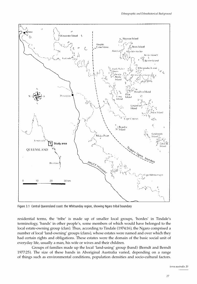
f'\ � \ t \ I "-r-'\. > ')
' O> ! \ "---..,\· / \ "-j )
Pn l�1:rpi Ill'
.f(lWllSV i l� � Study area
QU EENSLAND \ s,.; ,bane�
)
0 1 0 20 30 km
Ethnographic and Ethnolzistorical Background
I sland
Gnld �mith hland <0
I s l and
F igure 3 . 1 Centra l Queens land coast: the Whitsunday reg i on, showing Ngaro tr iba l boundary
residential terms, the 'tribe' is made up of smaller local groups, 'hordes' in Tindale's terminology, 'bands' in other people's, some members of which would have belonged to the local estate-owning group (clan). Thus, according to Tindale (1974:16), the Ngaro comprised a number of local 'land-owning' groups (clans), whose estates were named and over which they had certain rights and obligations. These estates were the domain of the basic social unit of everyday life, usually a man, his wife or wives and their children.
Groups of families made up the local 'land-using' group (band) (Berndt and Berndt 1977:25). The size of these bands in Aboriginal Australia varied, depending on a range of things such as environmental conditions, population densities and socio-cultural factors.
tcrra australis 20
27

The Sea People
There is, however, general consensus that they ranged from a general maximum of ea. 50 people to considerably fewer (Berndt and Berndt 1977:25; Hiatt 1987).
Tindale's (1974) tribal boundaries have been shown in some cases to be far from accurate (e.g., David et al. 1994; Merlan 1989). However, by utilising a range of historical, ethnographic and archaeological data, a fairly clear picture of the extent of the Ngaro domain can be defined (see Fig. 3.2).
Defining Ngaro territory James Morrill, a sailor on board the Peruvian shipwrecked in 1846 off the central Queensland coast, lived with Aboriginal people near Cape Cleveland (Townsville) for 17 years. He relates how his 'tribe' had a large corroboree in the dry season, with more than 1000 people from 10 different 'tribes' attending (Gregory 1896). When Morrill heard that one of the tribes was from 'far to the south', he left with three other survivors and went with the southern group.
This group travelled as far south as the future Port Denison (Bowen). Although Morrill's account is frustratingly general, it does indicate that there were at least two 'tribes' between Cape Cleveland and Bowen (a distance of 200km), who interacted ceremonially and probably also for a range of social and material exchanges. Morrill also indicates that both these groups were coastal. That the southern group was a different 'tribe' rather than a local group is indicated by explicit statements of 'otherness' relating to 'tribes' and the hostilities and tensions expressed between the two groups in relation to 'pocession [sic] of the white survivors' (Morrill cited in Gregory 1896:15).
Other supportive evidence of cultural distinctiveness comes from J. Beete Jukes, the naturalist on board HMS Fly. He observed that the people on the south-east side of Cape Cleveland (Bindal) had scarification and tooth avulsion practised on men, but not on women. At Cape Upstart, however, men and women of the Juru had scarification and tooth avulsion.
They were all more or less scarred and had lost one front tooth. The women were also scarred
especially over the hips and had likewise each lost a front tooth (Jukes 1847:81-4, 5 May, 1843).
Furthermore, when the Fly returned from Cape Cleveland to Upstart Bay, Jukes identified the group with which they had previously had contact and observed a second group which he distinguished as a separate people. Jukes makes reference to two 'tribes', one of which had 'arrived from north of the river ' (probably the Burdekin), recording the different markings and decoration of the two groups and the tensions between them (Jukes 1847:81-4, 5 May, 1843).
All of Morrill' s account relates to the coastal region between Bowen and Cape Cleveland, with no reference to any interaction south of Port Denison. These 'boundaries' fit very closely with Tindale's Bindal group, located from Cape Cleveland south to the mouth of the Burdekin River and inland approximately 50km to the Leichhardt Range (Fig. 3.2). The 'boundaries' also fit with Tindale's Juru group, from the southern mouth of the Burdekin River south to Bowen and west approximately 40km to the Bogie River.
The 11 'tribes' attributed to the Burdekin River region listed in Curr (1886:v2:468-71), the Perenbba, Euronbba, Walmundi, Bendalgubber, Cumarinia, Culbaingella, Cobblebobber, Cartollonounger, Toolkenburra, Carnieyinburra and Tingulujller, are most likely to have been local groups (Tindale' s 'hordes'), which were part of the larger Bindal or Juru entity. The fact that there is one vocabulary provided for the 11 different groups tends to support this view. J. Hall Scott, Curr' s informant, does not state to which part of the Burdekin River he is referring: however, reference to the Leichhardt district and Mount Dalrymple in the word list appears to place these groups directly to the west of the coastal Juru, in the Biria 'tribal' group
terra aus tralis 20
28
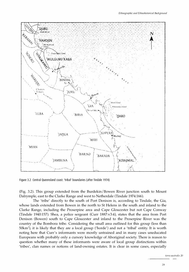
( 'h:1 rt1.'r,; ' r()wcr-. •
' I :LBA
'MIAN
'JAIJGA
'BAR:Nd
)AMBI :NA
F igure 3 .2 Centra l Queens land coast: 'tr iba l ' boundar ies (after T inda le 1 97 4)
Ethnographic and Ethnohis torical Background
N
t
, /look Island
Vi'hi1s11111/ay fshmd
< 'JJARO
(Fig. 3.2). This group extended from the Burdekin/Bowen River junction south to Mount Dalrymple, east to the Clarke Range and west to Netherdale (Tindale 1974:166).
The 'tribe' directly to the south of Port Denison is, according to Tindale, the Gia, whose lands extended from Bowen in the north to St Helens in the south and inland to the Clarke Range, including the Proserpine area and Cape Gloucester but not Cape Conway (Tindale 1940:157). Shea, a police sergeant (Curr 1887:v3:4), states that the area from Port Denison (Bowen) south to Cape Gloucester and inland to the Proserpine River was the country of the Bombora tribe. Considering the small area outlined for this group (less than 50km2), it is likely that they are a local group ('horde') and not a 'tribal' entity. It is worth noting here that Curr ' s informants were mostly untrained and in many cases uneducated Europeans with probably only a cursory knowledge of Aboriginal society. There is reason to question whether many of these informants were aware of local group distinctions within 'tribes', clan names or notions of land-owning estates. It is clear in some cases, especially
terra australis 20
29
The Sea People
where a large number of 'tribes' are recorded for a relatively small area (as in the examples above), that local clan and band groups rather than larger corporate entities were being identified.
Numerous names with terminations -bara and -bura are to be found in the earlier literature of
central Queensland from Gympie north to Townsville and west to Winton. They usually denote
horde-like units of local organisation and can seldom if ever be given the status of tribes
(Tindale 1940:143) .
In contrast, Roth's ethnographies (1897, 1901-06, 1907-10) show a much clearer understanding of Aboriginal society and an awareness of local group distinctions within tribes. Tindale (1974:168) derives his name Gia for this region from Roth's (1903:v5:19) descriptions of various activities of the Proserpine River Aborigines, whom he calls Kia. Roth (1903:v5:21) provides the totemic nomenclature of what he calls 'primary group divisions' (clans) for these people. These include Kurchilla: rainbow, opossum (s ic), ground-iguana (probably goanna), frilled lizard; Kupuru: stinging tree, emu, eel, turtle; Wungko: wind, rain, brown snake, carpet snake; and Bunburi: honey, stingray, bandicoot, eaglehawk. Bunburi is very close to Shea's Bumbarra, the group he identified as being a 'tribe' between Port Denison and Cape Gloucester (Curr 1887:v3:4).
The coastal group to the south of the Gia are called the Juipera, whose country, according to Tindale (1974:171), extended from St Helens in the north, south to Cape Palmerston and inland to the Connor Range. Curr ' s (1887:v3:44) informants, George Bridgeman, the Reverend Bucas and an anonymous informant, stated that within a radius of 50 miles (80km) of Port Mackay there were five 'tribes'. These were the Bumbarra (Gia), whose country was between Bowen and Repulse Bay in the south; the Yuipera (Juipera), whose territory was the Mackay town area; the Kungalburra between Mackay and Broad Sound in the south; the Tollginburra to the west of the Kungalburra; and the Googaburra or ' Island Blacks'. From the use of the suffix 'burra' in describing these groups, and the fact that, by the evidence collected by the three informants, the word lists from the various groups (clans) were identical, it again appears that smaller local groups are being identified. Therefore, Tindale (1974:176) is probably correct in grouping these five 'tribes' under the broader entities of Gia, Juipera and Koinjmal (Broad Sound area).
In this context, it seems likely that the Googaburra or ' Island Blacks' are a local group (clan) who inhabited either the Northumberland Islands to the east (including the Percy Islands) or the extensive islands in and around Broad Sound itself. This would accord well with the numerous historical accounts of regular but non-permanent occupation of many of these islands. Flinders, for example, visited the Percy Islands in October 1802, noting that:
[n]o inhabitants were seen upon any of the islands, but there were deserted fire places upon all .
The Indians probably come over from the main land at certain times, to take turtle . . . (Flinders
1966[1814] :v2:81 ) .
Similarly, he said of one of the nearby Duke Islands in September that 'proofs of natives having lately visited, or being perhaps then on the island, damped our prospects [of getting turtle]' (Flinders 1966[1814] :v2:55-6 ).
Captain J.W. Smith RN of the Spitfire, who visited the Pine and Percy Islands when attached to the Herald in 1859, visited them again during the expedition he commanded to the Burdekin in 1860, saying of them:
terra australis 20
30
This group . . . i s occasionally visited by natives, but they are not permanent inhabitants. During
our stay in the 'Herald' of one month in 1859, we saw none, but observed several indications of
their having been there (Smith 1860:2).
Ethnographic and Ethnohistorical Background
These are typical descriptions of the occupation of the Northumberland Islands, the island chain to the south of the Cumberland Islands, and of those around Broad Sound. When people were encountered, they were few in number and observations of canoes on these islands are rare.
This is in marked contrast to the northern Cumberland Islands (Whitsundays ), where descriptions of people, canoes and smoke from fires were common. The people of the northern Cumberlands had the separate tribal designation of Ngaro (Tindale 1940, 1974:182). This name was probably provided in unpublished oral information collected by Tindale from Cumberland Islander inhabitants of Palm Island (K. Frankland, John Oxley Library, pers. comm.). It is apparent, however, from the various historical accounts relating to the Cumberlands, especially the northern Cumberlands, that people were living permanently on these islands and that they were probably a separate 'tribal' entity.
Supporting evidence for this comes from Gilbert P. Whitley, an ichthyologist from the Australian Museum, Sydney, who recorded a language vocabulary while on Lindeman Island in 1933 (Whitley 1936). Although Whitley's statement is related largely to marine species and does not unequivocally establish a separate language for the Whitsundays, the detailed nomenclature of the species listed demonstrates intimate knowledge of, and a deep affinity for, the sea environment, suggestive of a marine-oriented people.
When collecting fishes and other marine creatures at Lindeman Island, Cumberland Group,
Queensland, I obtained their native names in the aboriginal language of the Whitsunday
Passage districts from 'Mugera' (Billy Mackenzie) and Frank, two natives now resident there.
Over one hundred names of both mainland and island species [all marine] are included . . . This
list shows that the aborigines discriminated between closely allied species . . . and they also had
names for various stars, bays, headlands, currents, clouds and other natural phenomena
(Whitley 1936:42).
Thora Nicholson, one of the second generation of Nicholsons who ran sheep on Lindeman Island from 1903, says that when she was a young girl in the early 1920s, Aboriginal people used to come over from Whitsunday Island to look for work during the shearing muster. She also confirms that Billy Mugera (as in Whitley's account) was from Whitsunday Island (Nicholson pers. comm. 1991).
Roth (1906:v8:11, 1910:v14:10, v15:27) also makes allusions to the Whitsunday people as a 'tribal' entity. He clearly distinguishes the 'Whitsunday Island folk' or the 'natives of Whitsunday Island' from other groups when referring to distinctive material culture items. Included in his accounts are canoes, paddles, shell ornaments, shell water carriers, dilly bags, harpoons, an 'axe' quarry and trade with the mainland.
An unpublished 1861 letter regarding the Cumberland Islands from A.C. Gregory (based in Port Denison) to the Chief Commissioner for Crown Lands clearly alludes to a permanent island population, distinguishing between island and mainland.
In reference to the general question of leasing the islands adjacent to the coast northward of
Broad Sound, it must be remarked that all the islands would seem suitable for improvement.
These islands are however more densely inhabited by the Aborigines, than any similar area of the mainland, and consequently their occupation would not only interfere with the resources
from which the natives derive their subsistence, but involve the necessity of maintaining a large police force for the protection of the lessees.
And finally, in 1881, Coppinger, on board the Alert, alludes to a separate island population.
terra australis 20
31
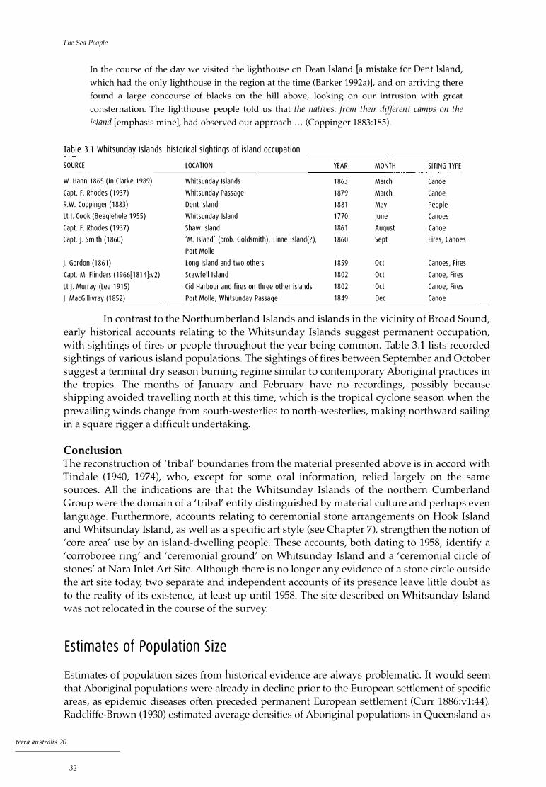
The Sea People
In the course of the day we visited the lighthouse on Dean Island [a mistake for Dent Island,
which had the only lighthouse in the region at the time (Barker 1992a)], and on arriving there
found a large concourse of blacks on the hill above, looking on our intrusion with great
consternation. The lighthouse people told us that the natives, from their differen t camps on the
island [emphasis mine], had observed our approach . . . (Coppinger 1883 :185) .
Tab le 3.1 Whitsunday I s la nds : h i storica l s ight ings of i s land occupat ion
SOURCE LOCATION YEAR MONTH S IT ING TYPE
W. Hann 1 865 ( in Clarke 1 989) Whitsunday Is lands 1 863 March Canoe
Capt. F. Rhodes ( 1 937) Whitsunday Passage 1 879 March Canoe
R.W. Coppinger ( 1 883) Dent Is land 1 881 May Peop le
Lt J. Cook (Beaglehole 1 955) Whitsunday Is land 1 770 June Canoes
Capt. F. Rhodes (1 937) Shaw Is land 1 86 1 August Canoe
Capt. J . Smith (1 860) 'M. Is land' (prob. Goldsmith), Linne Is land(?), 1 860 Sept F i res, Canoes
Port Mol le
J. Gordon (1 861 ) Long Is land and two others 1 859 Oct Canoes, Fi res
Capt. M. Fl inders ( 1 966[1 81 4] :v2) Scawfe l l I s land 1 802 Oct Canoe, Fires
Lt J. Murray (Lee 1 91 5) Cid Harbour and f i res on three other is lands 1 802 Oct Canoe, Fires
J. MacGi l l ivray (1 852) Port Mol le, Whitsunday Passage 1 849 Dec Canoe
In contrast to the Northumberland Islands and islands in the vicinity of Broad Sound, early historical accounts relating to the Whitsunday Islands suggest permanent occupation, with sightings of fires or people throughout the year being common. Table 3.1 lists recorded sightings of various island populations. The sightings of fires between September and October suggest a terminal dry season burning regime similar to contemporary Aboriginal practices in the tropics. The months of January and February have no recordings, possibly because shipping avoided travelling north at this time, which is the tropical cyclone season when the prevailing winds change from south-westerlies to north-westerlies, making northward sailing in a square rigger a difficult undertaking.
Conclusion The reconstruction of 'tribal' boundaries from the material presented above is in accord with Tindale (1940, 1974), who, except for some oral information, relied largely on the same sources. All the indications are that the Whitsunday Islands of the northern Cumberland Group were the domain of a 'tribal' entity distinguished by material culture and perhaps even language. Furthermore, accounts relating to ceremonial stone arrangements on Hook Island and Whitsunday Island, as well as a specific art style (see Chapter 7), strengthen the notion of 'core area' use by an island-dwelling people. These accounts, both dating to 1958, identify a 'corroboree ring' and 'ceremonial ground' on Whitsunday Island and a 'ceremonial circle of stones' at Nara Inlet Art Site. Although there is no longer any evidence of a stone circle outside the art site today, two separate and independent accounts of its presence leave little doubt as to the reality of its existence, at least up until 1958. The site described on Whitsunday Island was not relocated in the course of the survey.
Est i mates of Popu l at ion S ize
Estimates of population sizes from historical evidence are always problematic. It would seem that Aboriginal populations were already in decline prior to the European settlement of specific areas, as epidemic diseases often preceded permanent European settlement (Curr 1886:v1:44). Radcliffe-Brown (1930) estimated average densities of Aboriginal populations in Queensland as
terra australis 20
32

Ethnographic and Ethnohistorica/ Background
one person per 17km2• However, from other historic and ethnographic information around Australia it is clear that population densities were often much greater in coastal areas (specifically tropical coasts), with densities of up to one person per 2km2 (Chase and Sutton 1987; Meehan 1982). It appears that 'tribal' groups in north-eastern Queensland averaged between 300-600 people, though they were often considerably smaller than this. These would be divided into smaller local groups (bands) of between 30-50 people (Chase and Sutton 1987; Dixon 1976).
One of the problems in estimating population densities of coastal peoples is that of incorporating the sea domain into the total area equation. In the Whitsundays the islands and coastal mainland are steep and sheer in most places and uninhabitable. The archaeological and historical record shows that people utilised mainly the coastal margins of these land areas, with their principal foraging domain being the marine environment. So, although the Cumberland Island group makes up a total land area of approximately 3500km2, the effective exploitable land area was much smaller. This effect, however, is offset by a long coastline and tracts of sea that can provide a considerably richer, more diverse and potentially more reliable resource base than most terrestrial environments.
This point is further illustrated by Meehan's (1982:15) work with coastal Anbarra people in northern Arnhem Land, in which she estimates that population densities at the time of European contact were one person per 2km2 or six per lkm of coast, a total of 300 people in approximately 650km2 • Other recorded population densities for island peoples around tropical Australia are all proportionally higher than average estimates for the rest of Australia. On the Keppel Islands, population estimates are >four people per km2 or two people per lkm of coast (estimated from 1 00 people over 22.5 km2). On Dunk Island they are estimated at three people per km2 (Banfield 1907; Rowland 1983). In temperate Australia population densities were generally lower, with estimates of 0.2 people per km2 or 1 .2 people per km of coastline on King Island in Bass Strait and 0.3 per km2 in the Furneaux Group (Jones 1976).
There are several general historical accounts of population sizes on the Cumberland Islands. Statements include those of Gregory (1861): 'These islands are . . . more densely inhabited by the Aborigines, than any similar area of the mainland', and Gordon (1861:4): 'The natives of the Cumberlands are numerous both on the mainland and the islands'. Such statements suggest a relatively dense and permanent population and are typical of early accounts. The frequency with which people are sighted in the Cumberland Islands, compared with islands to the south, further indicates relatively large resident populations in the former.
Figures relating to specific numbers of people on islands off the north-east coast of Australia include 400 people on Dunk Island and the adjacent mainland (Banfield 1907:53) and about 85 people on the Keppel Islands (Rowland 1983). Coppinger, a passenger on the Alert, noted in 1881 that a group of island Aboriginal people was using the Dent Island lighthouse as a refuge after a series of attacks by the Queensland Native Mounted Police in reprisal for an attack on the Louisa Maria in 1879. This group numbered 'in the order of forty or fifty . . . I was surprised at the large number of children' (Coppinger 1883:186). This statement demonstrates that 20 years after the settlement of Port Denison and the activities of the Native Mounted Police on the islands, a fairly large population of island Aboriginal people remained in the region. The disproportionate number of children may have been because numerous adults had recently been massacred, as Coppinger (1883:185) seems to indicate. If we are to accept that most of the 'forty or fifty' people were children, as implied, we can assume that a much higher population was unaccounted for, perhaps due to the activities of the Native Mounted Police. This is conservatively estimated as at least an additional 50 people, but is probably considerably more. An estimate of 90 to 100 people would be conservative when compared with historical and ethnographic accounts of densities in similar coastal environments elsewhere in northern Australia.
terra australis 20
33

The Sea People
Trade and Reg iona l I nteractio n
According to historical accounts, the main area of interaction and trade for the N garo of the Whitsunday Islands was the mainland directly to the west. Roth (1904:v7:29) states that the Whitsunday Island people used baler shell (Melo amphora) as a water carrier, which 'from the eastern sea-board finds its way, by trade and barter, to considerable distances inland'. In 1844, in the Cape River area, about 200km inland from the central Queensland coast, Leichhardt (1964[1847] :257) recorded passing a group of Aborigines who were on their way 'to the seacoast, pointing to the east and east by south, whither they were going to fetch shells, particularly the nautilus, of which they make various ornaments'.
He also records examining the contents of a hastily abandoned camp and being surprised to find 'two tomahawks, one of stone, and a smaller one of iron, made apparently from the head of a hammer: a proof that they had some communication with the sea coast' (Leichhardt 1964[1847] :163).
From Morrill's account (Gregory 1896:15), it appears that there was interaction between the coastal groups from Townsville down to at least Bowen (Port Denison). There is also archaeological evidence to suggest contact between the Whitsunday Island Ngaro people and the Port Denison people, in the presence of artefacts of black tuff like that from the South Molle Island quarry on the coast at various locations in the Bowen region (Barker and Schon 1994) . Many historical accounts illustrate an apparent similarity of material culture between coastal groups from around the Mackay area northwards. This relates not only to canoes, but to dwellings, shields and wooden swords . Comments such as those made by Cook (Beaglehole 1955:337) in the Whitsunday Passage about 'a Canoe with an outrigger that appeared to be both larger and differently built to any we have seen upon the Coast' are typical of statements which seem to link this part of the coast to what may be a broader northern coastal I marine social, economic and political system (see also Rowland 1986).
Recent petrological analyses have tentatively indicated that material from the South Molle Island Aboriginal quarry was distributed over a considerable distance along the coast, indicating a north-south island I coastal zone of interaction, perhaps involving trade, intermarriage and political alliances (see Barker and Schon 1994). This suggests a pattern of interaction similar to that described for the Dunk Island Aborigines by Banfield (1907:62) below, in which they maintained so large a fleet of bark canoes as to astonish one pioneer settler.
The population floated from island to island as far south as Hinchinbrook, but does not appear
to have voyaged north, or to have had much communication with the mainland. As far as I have
been able to ascertain there were more terms in common between the natives of Dunk Island
and those of the far end of Hinchinbrook ( 40 miles [ 64km away] ) than with the mainland
natives two and a-half miles [4km] removed.
Resou rce Use
A wide range of resources is documented as being utilised by Aborigines on the central Queensland coast. It could be argued that a bias towards marine species exists in the early historical accounts, given the coastal nature of most early observations. However, when the overall historical and archaeological evidence relating to tribal boundaries, subsistence and technology is taken into account, it is clear that we are not looking at a terrestrially based people occasionally utilising a marine resource (see Chapter 12). Rather, what emerges is a more or less specialised marine economy which is, in many ways, similar to contemporary accounts of coastal peoples further to the north on Cape York (Chase and Sutton 1987; Hale
terra australis 20
34
Ethnographic and Ethnohistorical Background
and Tindale 1933; Thomson 1934, 1956). A number of accounts of the marine economy, as observed in the historical record, provide detailed evidence of this resource base.
There is a discrepancy between a historical emphasis on the scale of fishing and hunting of other marine organisms and an archaeological one emphasising shellfish. The historical record in north Queensland indicates an emphasis on large marine animals such as turtle and dugong, in addition to fish, with few accounts relating to shellfish gathering. That the large and economically important resources are often under-represented in north Queensland archaeological sites has more to do with taphonomic processes and specific behaviours relating to procurement, butchering, distribution and disposal of large heavy carcasses, together with specific procedures relating to the disposal of dugong (Dugong dugon) bone (Minnegal 1984a, 1984b; Smith and Kinahan 1984), than with subsistence practices per se. The following account, from a contemporary Aboriginal group in the Gulf of Carpenteria, neatly illustrates this point in relation to dugong.
After the meat has been eaten, all the scraps and bones are thrown back into the ground oven
and burnt. The belief is that failure to dispose of the bones correctly will result in a cessation of
successful hunting . . .
. . . The skull of a dugong is usually thrown back into the sea or river. This is why few dugong
skulls are ever found at camp sites . . . (Bradley 1988:109) .
Similar observations have been made by numerous observers in north Queensland, for example, by Thomson about the Yintjingga 'sand-beach people' north of Princess Charlotte Bay, Cape York Peninsula.
When the flesh has been eaten, the bones of the dugong are also collected and thrown into the
water . . On the Stewart River, the bones of dugong and turtle were frequently to be seen lying
in the river bed . . . (Thomson 1934:253).
Of all the available accounts of resource activity recorded between 1770 and 1904 on the coast of Queensland between Port Curtis (Gladstone) and Dunk Island, 28% relate to fish or fishing, 10% to dugong procurement, 24% to turtle, 2% to cetacean, 6% to crab, 14% to plant foods, 4% to terrestrial fauna and 12% to shellfish or shellfishing (Table 3.2). I stress that, overall, shellfish made up only 12% of observations. Elsewhere, Meehan (1982:159) states that the contribution of shellfish to the diet of the contemporary northern Australian coastal Anbarra ranged between 10% and 30% in terms of meat weight, but only between 6% and 17% in terms of energy contribution. Bailey (1975, 1978) has also pointed out that when compared with other resources, shellfish do not offer a great calorific return, noting that for northwestern Europe more than 50,000 oysters is equal to one red deer.
Turtle
Studies of contemporary Aboriginal marine resource procurement among coastal peoples in eastern Cape York Peninsula at Hopevale (population about 500) emphasise the importance of turtle and dugong in the diet and thus reflect the historical accounts. Up to 26 green turtles (Che Zonia mydas ) are procured in a month, with a yearly average of 6.5 per month or 1.6 per week (Smith 1989). This equates to a yield of approximately 90kg of meat a week from turtle alone, based on an average size of an adult green turtle of 80-lOOkg, giving some 60kg of meat per animal.
The historical record indicates that turtle procurement on the central tropical coast was on a similar scale, with accounts frequently stating that turtle seemed to be the principal food, stressing the abundance of turtle remains found in Aboriginal occupation sites and
terra australis 20
35
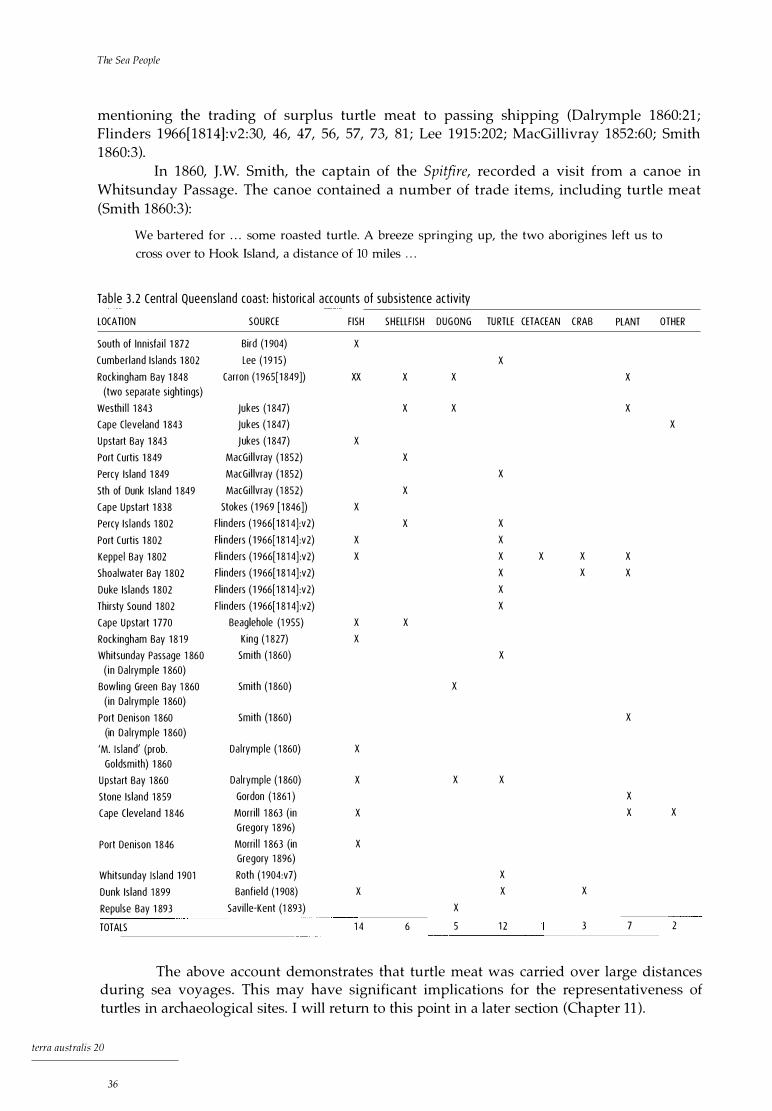
The Sea People
mentioning the trading of surplus turtle meat to passing shipping (Dalrymple 1860:21; Flinders 1966[1814]:v2:30, 46, 47, 56, 57, 73, 81; Lee 1915:202; MacGillivray 1852:60; Smith 1860:3).
In 1860, J.W. Smith, the captain of the Spitfire, recorded a visit from a canoe in Whitsunday Passage. The canoe contained a number of trade items, including turtle meat (Smith 1860:3):
We bartered for . . . some roasted turtle. A breeze springing up, the two aborigines left us to
cross over to Hook Island, a distance of 10 miles . . .
Tab le 3 . 2 Centra l Queens land coast: h i storica l accounts of subs i stence act iv ity
LOCATION
South of lnn isfa i l 1 872
Cumber land Is lands 1 802
Rockingham Bay 1 848 (two separate sighti ngs)
Westh i l l 1 843
Cape Cleveland 1 843
Upstart Bay 1 843
Port Curt is 1 849
Percy Is land 1 849
Sth of Dunk Is land 1 849
Cape U pstart 1 838
Percy Is lands 1 802
Port Curt is 1 802
Keppel Bay 1 802
Shoalwater Bay 1 802
Duke Is lands 1 802
Thirsty Sound 1 802
Cape Upstart 1 770
Rockingham Bay 1 8 1 9
Whitsunday Passage 1 860 ( in Da l rymple 1 860)
Bowl ing Green Bay 1 860 ( in Da l rymple 1 860)
Port Denison 1 860 (in Da l rymple 1 860)
'M. I s land' (prob. Goldsmith) 1 860
Upstart Bay 1 860
Stone Is land 1 859
Cape Cleve land 1 846
Port Denison 1 846
Whitsunday Is land 1 901
Dunk Is land 1 899
Repulse Bay 1 893
TOTALS
SOURCE
Bird (1 904)
Lee ( 1 9 1 5)
Carron (1 965(1 849])
Jukes (1 847)
Jukes ( 1 847)
J ukes ( 1 847)
MacGi l lvray ( 1 852)
MacGi l lvray ( 1 852)
MacGi l lvray (1 852)
Stokes ( 1 969 [ 1 846])
F l inders ( 1 966[1 81 4] :v2)
Fl i nders ( 1 966(1 8 1 4] :v2)
Fl i nders ( 1 966[1 8 1 4] :v2)
F l inders ( 1 966[1 8 1 4] :v2)
F l inders ( 1 966[1 8 1 4] :v2)
F l inders ( 1 966[1 8 1 4] :v2)
Beaglehole (1 955)
King ( 1 827)
Smith ( 1 860)
Smith ( 1 860)
Smith (1 860)
Da l rymple ( 1 860)
Dalrymple ( 1 860)
Gordon ( 1 861 )
Morri l l 1 863 ( in G regory 1 896)
Morri l l 1 863 (in Gregory 1 896)
Roth ( 1 904:v7)
Banfield (1 908)
Savi l le-Kent (1 893)
F ISH SHELLF ISH DUGONG TURTLE CETACEAN CRAB
x
xx
x
x
x
x
x
x
x
x
x
x
x
1 4
x
x
x
x
x
x
6
x
x
x
x
x
5
x
x
x
x
x
x
x
x
x
x
x
x
1 2
x x
x
x
3
PLANT OTHER
x
x
x
x
x
x
x
7
x
x
2
The above account demonstrates that turtle meat was carried over large distances during sea voyages. This may have significant implications for the representativeness of turtles in archaeological sites. I will return to this point in a later section (Chapter 11).
tcrra australis 20
36
Ethnographic and Etlrnohistorical Background
Du gong The evidence for dugong (Dugong dugon) procurement in the historical records is less prevalent than for that of turtle. This may be because of specific restrictions relating to the disposal of dugong bone in many parts of north Queensland, as discussed above. The specific harpoon technology employed in dugong procurement during historical times was very similar to that used in contemporary Aboriginal dugong hunting in northern Australia. Such a technology was observed in the Whitsunday Islands during historical times and a component of this technology has also been recorded archaeologically at Nara Inlet 1 (see Chapter 6).
On the expedition to the Burdekin aboard the Spitfire Dalrymple (1860:29) noted the butchering of dugong for roasting at Upstart Bay, describing the 'very systematic manner ' in which the meat was cut up, 'using for knives pieces of sharp edged quartz'.
Contemporary accounts from Hopevale, with its population of about 500 people, put dugong procurement at 25 per year or approximately two per month. This works out at approximately 600kg of meat per month or 1.2kg per person per month (Smith 1989) . It must be stressed that outboard motors are used in dugong and turtle hunting in contemporary Aboriginal society and that new technologies may enable a larger procurement rate of these species. Certainly, outboards have simplified hunting procedures (B. Colless pers. comm. 1995); however, population concentrations such as those experienced at Hopevale today would probably not have existed in the prehistoric/historic period.
Other According to historical accounts, fish in the Whitsundays were taken by hook and line, spear, nets and traps and often from canoes. At Rockingham Bay in 1848, Carron (1965[1849] :9) met 'several natives who had been fishing. Most of the fish they had taken had been speared, but few having been caught with hooks.'
Another dietary component mentioned in the historical record is that of plant foods. It is widely acknowledged that plant foods were an important component of the Aboriginal resource base (Meehan 1982:151). Many of the historical accounts attest to the importance of plant foods in the diet of north Queensland Aboriginal people. Thus Leichardt, on his expedition to Port Essington in 1845:
. . . I met a family of natives who had just commenced their supper; but, seeing us, they ran
away and left their things, without even making an attempt to frighten us. Upon examining
their camp, I found their koolimans (vessels to keep water), full of bee bread, of which I partook,
leaving for payment some spare nose rings of our bullocks. In their dillies I found the fleshy
roots of a bean, which grows in a sandy soil, and has solitary yellow blossoms; the tuber of a
vine, which has palmate leaves; a bitter potato, probably belonging to a water-plant
(Leichhardt 1964(1847] :279) .
He went on to say that '[t]here was no animal food in the camp' . In the Whitsunday region historical evidence of vegetable food procurement comes
from Stone Island in Edgecumbe Bay (Port Denison). For example, we have Juke' s account of a visit in 1843.
At the foot of the hill we crossed a small marsh, now dry in which grew a very tall reed-like
grass, large spaces of which had recently been pulled up by the roots, bare clods and the loose
grass lying about in heaps. The root of this grass is probably eaten by the natives, and it was the
only sign we saw of their presence except some large smokes rising a few miles further to the
north (Jukes 1847:42).
terra australis 20
37

The Sea People
In 1859, James Gordon, a partner in the Louisa Maria expedition,
[s]aw a great many native tracks, also several acres of ground resembling a garden, completely
dug over by the natives, which was a greater mark of industry than we were prepared to give
them credit for. The ground in this place was full of a vegetable resembling nuts in shape and
flavour [probably Vigna lancelota (Cribb and Cribb 1987; Moore 1979)] (Gordon 1861 :8) .
A year later, in 1860, Captain Smith of the Spitfire noted of Stone Island that '[t]he natives frequently visit the island, as there were late diggings in the central part, for a root which somewhat resembles a species of Dioscoria? [sic] ' (1860:11).
A number of historical accounts comment on the use of vegetable foods by the Aboriginal people encountered. It would appear from some of these accounts that Stone Island was the source of relatively large-scale plant procurement activity.
Ca noes and Techno l ogy
One of the features of the historical accounts relating to the central Queensland coast is the repeated reference to canoes. From these observations there appear to be regional differences in canoe technologies along the coast.
Outrigger canoes Cook's description of an outrigger canoe in the Whitsunday Islands is one of only two occasions when the type was observed there (Beaglehole 1955:337). Indeed, from his seminal work with James Homell on canoes in Oceania, Haddon (1937:179) states that the southernmost extent of outrigger canoes on the east coast of Australia was at latitude 18° 40'S (Palm Islands), some 300km north of the Whitsunday Islands, but Cook's observation is confirmed by Banks and Pickersgill, the master's mate on the Endeavour (Beaglehole 1955:337). Edwin Augustus Porcher, the ship's artist on board the Fly, painted a watercolour of a single outrigger canoe off Cape Hillsborough in 1843 (Plate 3.1). According to researchers who have assessed Porcher's work, this is probably an accurate representation of what he observed (Rowland 1986:75).
Plate 3 . 1 Centra l Queens land coast: outr igger canoe, Cape H i l l sborough (Porcher 1 843, in Rowland 1 986:75) .
terra australis 20
38

Ethnographic and Ethnohistorical Background
Bark canoes While there is no doubt that outrigger canoes were present in the Whitsunday Islands at the time of European contact, it is equally evident that three-piece bark canoes were the most common form of water transport in the region (Table 3 .3), as far north as the Palm Islands, where Haddon (1937:179) places the southern boundary of outrigger distribution. This would seem to be substantially correct in that the predominant canoe used and built below the Palm Islands was indeed the bark canoe. Thus it may be that the outriggers observed in the Whitsunday region were visitors from the north.
With the bark canoes recorded from Port Curtis to the Palm Islands major differences in construction and use are evident. Many of the observations of bark canoes to the south and north of the Whitsunday Islands relate to single-piece bark vessels of relatively crude construction, with pieces of bark or wood for paddles. Canoes used by people in the Keppel Islands are described as one-piece bark canoes made of a single sheet of ironbark or stringybark, but the most common form of water transport appears to have been log rafts (Roth 1910:v14:4) . The southernmost extent of three-piece bark canoes as described by Roth (1910:v14:10), Dalrymple (1860) and others is at Torilla near Broad Sound (Table 3.3). Here, Lumholtz (1889:340) describes a three-piece bark canoe which appears to be inferior to that of the Whitsunday Islanders. From Roth's (1910:v14:10) account and photograph, the three-piece
Tab le 3 . 3 Centra l Queens land coast: h i storica l accounts of canoe s ight ings
LOCATION SOURCE TYPE NUMBER NO. OF OCCUPANTS
Port Curtis 1 802 F l inders ( 1 966[1 8 1 4]:v2)
Keppel Is lands 1 893 Roth ( 1 9 1 0:v1 4) Keppel Is lands 1 898 Roth ( 1 9 1 0:v1 4)
Is land Head 1 802 F l inders ( 1 966[ 1 81 4] :v2)
Shoa lwater Bay 1 802 Fl inders ( 1 966[1 81 4] :v2)
Tori l l a 1 881 Lumholtz (1 889) 3 -p iece bark 2
Cape H i l lsborough 1 843 Rowland ( 1 986) single outrigger
'M. Is land' (prob. Goldsmith) 1 860 Smith ( 1 860) 3 -piece bark 6 Da l rymp le ( 1 860) 3-p iece bark 5 1 for 1 canoe
Cape Conway 1 81 9 King ( 1 827) bark
Whitsunday Is land 1 901 Roth ( 1 91 0:v1 4)
Whitsunday Island 1 802 Lee ( 1 91 5) bark Whitsunday Is land 1 770 Beaglehole ( 1 955) s ing le outrigger 3
Whitsunday Passage 1 849 MacGi l l ivray ( 1 852) bark Whitsunday Passage 1 860 Da l rymple ( 1 860) 3-p iece bark Port Denison 1 877 Brayshaw (1 990) 3-p iece bark Bowl ing Green Bay 1 860 Smith ( 1 860) unspecif ied Cape Cleveland 1 860 Da l rymple ( 1 860) 1 -p i ece bark 6 or 7 Magnetic Is land 1 860 Smith ( 1 860) unspecif ied 2
Da l rymple (1 860) unspecified 2 Hal ifax Bay 1 860 Smith (1 860) unspecif ied 2 3 or 4 Palm Is land 1 8 1 9 King ( 1 827) 1 -p iece bark 2 Palm Is land 1 848 Huxley ( 1 935) outrigger 5 or 6
Palm Island 1 848 Huxley (1 935) bark Several
Goold Is land 1 81 9 King ( 1 827) 1 -p iece bark 5 1 or 2
Rockingham Bay 1 843 Jukes ( 1 847) bark 5
Rockingham Bay 1 848 Carron ( 1 965(1 849]) 1 -p iece bark Several Several
Rockingham Bay 1 849 MacGi l l ivray ( 1 852) bark 8 2
Dunk Is land 1 849 MacGi l l ivray ( 1 852) bark Several
terra australis 20
39

The Sea People
Plate 3 .2 Centra l Queens land coast: three-piece bark canoes, Wh itsunday Is land (Roth 1 91 O:v1 4 : Plate V) .
sewn bark canoes and paddles on Whitsunday Island are identical to those described by Dalrymple (below) for 'M. Island' (probably Goldsmith Island) in the Cumberlands in 1860, which Captain Smith (1860:3) says were 'of the same description and dimension' as those seen in the Whitsunday Passage a few days later.
18. Four very neat canoes were found close to the beach, and another was seen paddled by a
native at the opposite side of the harbour. They are formed of three sheets of bark taken from a
Eucalyptus; are about 8 feet [2 .44m] long, 31 / 2 feet [ l .Olm] broad, and 20 inches [Slcm] deep;
are pointed and turned up at both ends, and are very neatly and strongly sewn together with a
long, tough, cane-like creeper. Two cross sticks between the gunwales keep the whole in form.
19. In each canoe was a very neatly-made paddle, ornamented with crosses of red paint, or
raddle, on the blade (Dalrymple 1860:14).
A three-piece bark canoe, collected from Port Denison for the former Godeffroy Museum of Hamburg and now in the Museum fur Volkerkunde, Berlin (Brayshaw 1990:301), is shown in Plate 3.3b (from Brayshaw 1990:103, Plate 7-38). It is nearly 3m long and of sturdy construction. Although it is not stated that the paddle in the canoe is also from Port Denison, it is almost identical to those shown in Roth's photograph on Whitsunday Island (Roth 1910:v14:Plate V).
Bark canoes north of Cape Upstart are similar to those near the Keppel Islands. Dalrymple states that at Cape Cleveland
terra australis 20
40
[t]he . . . canoe taken from the natives . . . was quite different from the others along the coast,
being formed of one large sheet of bark about 10 feet [3.0Sm] long, sewed up at either end with
the same cane-like creeper used for this pu rpose all down the coast, and was capable of
carrying 6 or 7 men . The paddle was of different and more rude construction than those farther
south . . . (Dalrymple 1860:24).
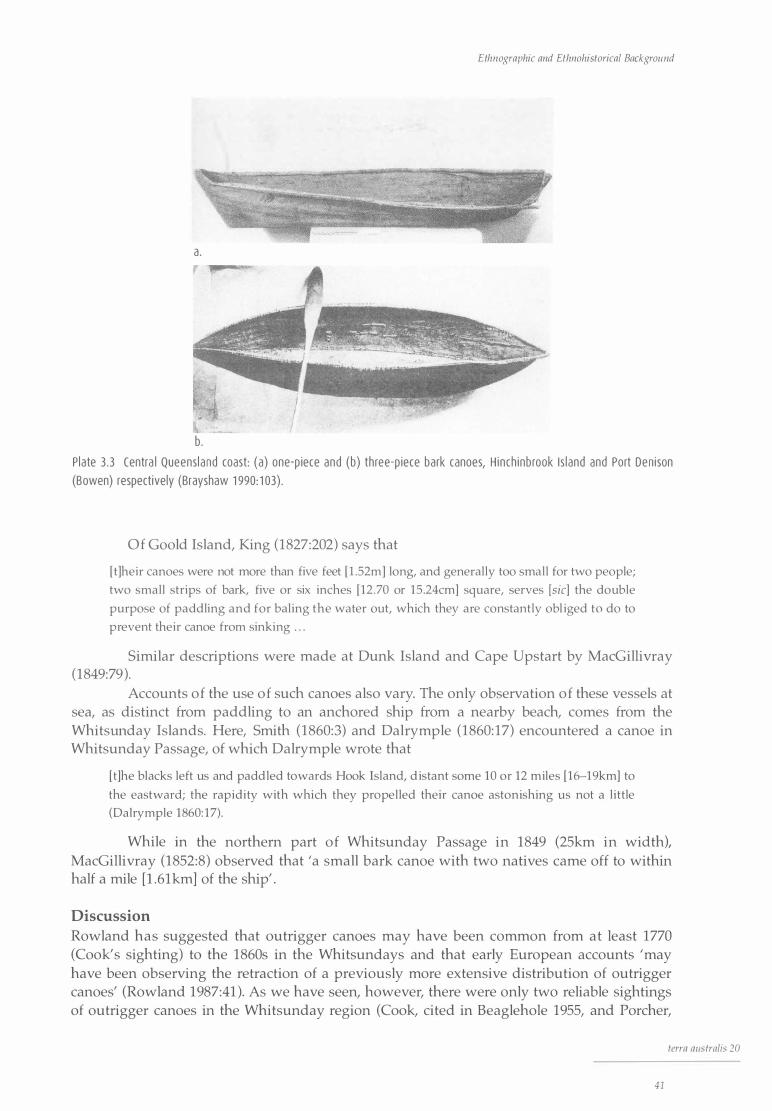
Ethnographic and Ethnohistorical Background
a.
b . P late 3 .3 Centra l Queensl and coast: (a) one-p iece and (b) three-p iece bark canoes, H i nch inb rook I s land and Port Den i son (Bowen) respectively (Brayshaw 1 990: 1 03) .
Of Goold Island, King (1827:202) says that
[ t]heir canoes were not more than five feet [ l .52m] long, and generally too small for two people;
two small strips of bark, five or six inches [12 .70 or 15 .24cm] square, serves [s ic] the double
purpose of paddling and for baling the water out, which they are constantly obl iged to do to
prevent their canoe from sinking . . .
Similar descriptions were made at Dunk Island and Cape Upstart by MacGillivray (1849:79).
Accounts of the use of such canoes also vary. The only observation of these vessels at sea, as distinct from paddling to an anchored ship from a nearby beach, comes from the Whitsrmday Islands. Here, Smith (1860:3) and Dalrymple (1860:17) encountered a canoe in Whitsunday Passage, of which Dalrymple wrote that
[ t]he blacks left us and paddled towards Hook Island, d istant some 10 or 12 miles [ 16-19km] to
the eastward; the rapidity with which they propelled their canoe astonishing us not a l ittle
(Dalrymple 1860: 17).
While in the northern part of Whitsunday Passage in 1849 (25km in widtht MacGillivray (1852:8) observed that 'a small bark canoe with two natives came off to within half a mile [l .61km] of the ship' .
Discussion Rowland has suggested that outrigger canoes may have been common from at least 1770 (Cook's sighting) to the 1860s in the Whitsundays and that early European accounts 'may have been observing the retraction of a previously more extensive distribution of outrigger canoes' (Rowland 1987:41). As we have seen, however, there were only two reliable sightings of outrigger canoes in the Whitsunday region (Cook, cited in Beaglehole 1955, and Porcher,
terra australis 20
41

The Sea People
cited in Rowland 1986) as against eight of bark canoes. It seems odd that people utilising an effective technology such as outrigger canoes would forsake them for the less permanent and less robust three-piece bark canoes. It is more likely that outrigger canoes were never common in the region.
Rowland (1987:41) states further that three-piece bark canoes were not referred to before the 1840s and might in fact have been a late development in the area. However, bark canoes of some kind are mentioned prior to 1840 by Flinders (1966[1814]:v.2:47) and by Lt Murray (Lee 1915:198) in 1802 and were clearly common in the area. Flinders makes no mention of outrigger canoes. Unfortunately, he rarely provides any detail as to the construction of canoes, simply stating that a 'bark canoe' was observed. The fact, however, that people were voyaging out as far as the Percy Islands in them would suggest that they were indeed three-piece bark canoes and not the more flimsy one-piece types described elsewhere (Flinders 1966[1814]:v2:81).
Other material culture Items of material culture recorded for the Whitsunday region exhibit a range typical of north Queensland. They include large wooden swords and shields, barbed spears cut out of single pieces of wood, and single-piece canoe paddles carved with elaborate decoration (Brayshaw 1990:260; Dalrymple 1860:14; Roth 1910:v14:Plate V ).
The most detailed descriptions of material culture items available relate to artefacts associated with marine procurement. Dalrymple lists the contents of the canoes he saw at what was probably Goldsmith Island in 1860 as including:
[s]everal large shells to hold water or bail out, a piece of [the orchid] Vauda Ccruliensis [sic] of
about 6 inches [ 15.24cm] long (purpose unknown), a long coil of fishing line very neatly made,
probably of the fibre of the Pandanus Palm-leaf, and to which was attached a spear head of about
5 inches [ 12.70cm] in length neatly barbed, and pointed with a very hard and sharp fish bone.
These spear heads are fitted into a socket in the end of a long spear, which the blacks throw
from their canoes with considerable precision into dugong, turtle, or other large fish
(Dalrymple 1 860: 14) .
In respect of the orchid, Dr M.A. Clements of the Australian National Botanic Gardens (pers. comm. 2003) thinks that what is meant is the plant now known as Durabaculum nindii and that it may have been carried as a good luck token, as he has noted of orchids in some coastal districts of northern Australia and New Guinea.
Of an encounter with two Aborigines in a canoe in Whitsunday Passage, Dalrymple (1860:17) says: 'We exchanged with them empty bottles, and wax vesta boxes, for fishing spears, lines and hooks ingeniously cut out of tortoiseshell'.
There are similar descriptions by Roth (1904:v7:32, 1910:v14:5).
Other Northern Coasta l Observa t ions
The subsistence pattern of the Whitsunday Aboriginal populations is almost identical to that described for various other northern coastal peoples on Cape York and the Gulf of Carpenteria. This is so not only in the historical period but among contemporary populations. Dugong, turtle and other marine resources were and are the economic mainstay, with people strongly identifying as 'sea people' or 'saltwater people' (Chase and Sutton 1987; Hale and Tindale 1934; Thomson 1934; Trigger 1987). Contrary to expectations based on a superficial
terra australis 20
42

Ethnographic and Ethnohistorical Background
view of the archaeological literature, however, shellfish do not appear to have been predominant in the subsistence economy. Detailed ethnographic accounts of coastal peoples of northern Cape York Peninsula provide a picture similar to that of the Whitsunday Islands, indicating the ultimate importance of the sea domain to social and economic life, including subsistence, settlement, social organisation, regional interaction, belief systems, ceremonial practices and world views.
Chase and Sutton state that there was a shared perception between the various coastal groups of central eastern Cape York Peninsula, based on their self-recognition as beach-side peoples, with similar patrimoiety divisions and a common pattern of initiation and ceremony. Importantly, these coastal peoples recognised and shared a typical marine pattern of exploitation reliant on fish, dugong and turtle, with the use of specialised marine technologies in the form of outrigger canoes, harpoons and fish-hooks, as well as a similar employment of magical knowledge considered essential to the capture of these animals (Chase and Sutton 1987:69).
Earlier Thomson (1934:237) had made a similar point:
The eastern seaboard of Cape York Peninsula is inhabited by a group of fishing and seafaring
tribes whose culture differs considerably from that of the typical Australian aboriginal. The
contrast between the sandbeachmen and the inland tribes, even within the Peninsula, is
recognised by the natives themselves . . .
He describes them as:
splendid seafaring people . . . In small dugout canoes with only a few inches of freeboard, they
make long journeys to the islands and sandbanks inside the Great Barrier Reef, hunting dugong
and turtle with the long harpoon (Thomson 1934:238).
In a paper investigating the relations of mainland coastal groups with offshore island societies in the Gulf of Carpenteria, Trigger (1987) states that although coastal mainland groups are in some ways included in the broad cultural bloc of inland peoples to the west and south-west, they are clearly on the periphery of that system. He argues that the influence of continuing social relations with North Wellesley Islanders kept coastal mainland society on the periphery of the cultural system extending inland. He further states that major offshore island society exercises important influences over immediately adjacent mainlanders, thereby reinforcing tendencies towards cultural differentiation between the latter people and those further inland .
This trend towards cultural differentiation between coast and inland is a common feature in ethnographic accounts relating to coastal peoples elsewhere in the tropics. Spencer and Gillen (1904, cited in Trigger 1987:74) mention the very considerable uniformity of material culture in inland areas on the south-west side of the Gulf, 'until we come to the true coastal tribes, amongst whom we naturally meet with certain objects not present amongst the inland tribes'. Tindale (1974:121) states that there were 'great contrasts between the life and economies of the inhabitants of the coastal mangrove and saline shore flats and the ways of the scrub covered upland dwellers' . My aims here are not to present an exhaustive review of coastal versus inland systems in northern Australia, but simply to point out this recurrent theme in the literature in the context of the above discussions.
terra australis 20
43
The Sea People
D i scuss i on
From the available evidence a reasonable picture of various aspects of the subsistence and settlement system of the people of the Whitsunday Islands in the historical period can be formed. It seems fairly certain that the people of the Whitsundays were a 'tribal' entity and that the extent of their country was broadly that suggested by Tindale (1974:177), as far south as Goldsmith Island and as far north as islands near Port Denison (Fig. 3.2). Although contact and interaction appears to have been directed to peoples on the mainland immediately to the west, there is also strong evidence for important links with the north. Evidence for this can be seen in the presence of outrigger canoes and other items of material culture characteristic of northern peoples.
There is little question that the economy was marine-oriented, with large marine reptiles, marine mammals and fish providing the bulk of the animal subsistence base. This is reflected also in the known subsistence technology, which is either designed for marine procurement or made from marine products. The superior construction of canoes, their seaworthiness and the ability and confidence with which people paddled them over large distances of open water are further indications of important affinities with the marine environment. Ethnohistoric observations regarding the use of a large number of islands over a north-south stretch extending for some lOOkm in length, and the number of descriptions of simultaneous occupation of islands in the northern Cumberland Group, suggest the presence of a relatively mobile permanent occupation on Hook, Whitsunday and South Molle Islands, with perhaps seasonal movement to some of the other, smaller islands.
The accounts of coastal peoples that have been reviewed reveal the following general features: cultural distinctions between coastal and hinterland peoples; smaller-sized territories; correspondingly higher population densities; a greater social segmentation; greater linguistic diversity; and a high degree of technological specialisation and economic diversity.
Despite problems of relating the material culture correlates of behavioural activity to the archaeological record, the system described above can be expected to leave distinctive and characteristic physical traces in the archaeological record. I argue that these would include: 1) evidence of marine resource specialisation; 2) a technology either made from marine products or designed for their procurement; 3) a settlement pattern consistent with permanent island I coastal occupation; and 4) distinguishing cultural markers such as distinctive art styles.
These factors will be discussed in the light of the archaeological evidence in Chapter 11.
terra australis 20
44
Palaeoenvironments
THE ROLE of environment and environmental change in influencing and limiting cultural decision has long been seen as one of the major factors behind change as perceived in the archaeological record (d. Butzer 1982; Shackley 1981). Indeed, all human behaviour takes place in the context of broader natural environmental circumstances, although the latter cannot be said to define the former. Nevertheless, people are affected by the circumstances in which they live. Social strategies incorporate frameworks through which 'nature' is incorporated in the social and psychological fields, referred to as the social landscape.
Of major importance to the study of prehistoric human populations over relatively long periods of time is the reconstruction of the local environment in which people lived. There is little doubt that environmental conditions helped shape the activities of people on the ground. The archaeological literature abounds with ecological models, more often than not invoking environmental change as being the principal driving force behind 'culture change' as seen in the archaeological record. Many such examples can be cited from around the world, most of which focus on human populations in marginal environments, especially Arctic and desert regions and areas with seasonal extremes where the limiting effects of the environment can be profound. Because changes in economy and technology are the most visible components of archaeology, much research has focused on environmental change in its effects on resources and thus human groups (Beaton 1985; Chappell 1982; Head 1986; Woodroffe et al. 1988). While this is certainly true, it is also my contention that these 'effects' may vary considerably on a regional basis, so that, for example, on steep rocky coasts post-glacial rise in sea level did not require drastic changes to existing settlement I subsistence systems or other aspects of social and economic life. Indeed, it is argued here that people on the coast were always coastal people and that they moved easily and comfortably with the changing coastline, exploiting quickly established and readily available marine resources.
This chapter presents a general examination of the palaeoenvironments of the Holocene period of northern Australia from geomorphological, palynological and sea-level data, before more specific environmental data relating to the study region are outlined.
Chronology is initially discussed on the basis of uncalibrated radiocarbon dates, expressed as 'bp' .
terra australis 20
45
The Sea People
Pa l aeoenvi ronments i n Northe rn Austra l i a
Palynological evidence Some of the most detailed reconstructions of the late Quaternary period in northern Australia come from palynological investigations on the Atherton Tableland, 500km to the north of the Whitsunday Islands. These comprise work at Lake Barrine (Chen 1988; d. Walker and Chen 1987) and Lake Eacham (Goodfield 1983), as well as Kershaw's (1970, 1971, 1975, 1983) studies of core samples from four volcanic craters: Lynch' s Crater, with a record from beyond 120,000 years ago to 10,000 bp; Lake Euramoo, 9700 to 1500 bp; Quincan Crater, 7250 bp to the present; and Bromfield Swamp (not further discussed), 10,500 bp to the present.
Late Pleistocene The pollen data from Lynch' s Crater demonstrate distinct periods of change during the period of human occupation on this continent. At the time of settlement araucarian vine forests similar to those found in present-day south-east Queensland were dominant, indicating an average rainfall range between 900mm and lOOOmm. A significant increase in burning associated with the emergence of sclerophyll vegetation has been the subject of recent restudy (Turney et al. 2001). This replaces Kershaw's original date of ea. 38,000 bp with one of ea. 45,000 bp and strengthens his suggestion that the change in fire frequency resulted from early human impact. The vegetation shift continued to ea. 28,000 bp (the earlier estimate was ea. 26,000 bp) and from then to ea. 15,000 bp dry scheroplhyll woodland predominated in what is generally agreed to have been the driest period of the past 50,000 years. During this time temperatures also probably fell to their lowest levels (Kershaw 1981). The period from 15,000 bp to the beginning of the Holocene witnessed a general increase in precipitation and temperature, although sclerophyll vegetation was still dominant.
Holocene The evidence from Lake Euramoo shows that from 9700 bp until 7600 bp sclerophyll forests, especially those of Myrtaceae and Casuarina, dominated the Tableland, probably with a grassy ground cover (Kershaw 1970) . Rainforest communities re-emerged only after ea. 7600 bp. During this time there was a shift from dry sclerophyll to wet sclerophyll forest, evident in a change from, for example, Eucalyptus to Casuarina species. After 7600 bp warm temperate (submontane) rainforests predominate, followed by dry subtropical rainforests. Kershaw (1983) argues that this change implies an increase in mean temperatures, although not necessarily in precipitation (d. Walker and Chen 1987).
The pollen data from Quincan Crater, spanning the period from 7250 bp to the present, is in general accordance with the Euramoo material (Kershaw 1971), with rainforests reaching their maximum distribution by ea. 6000 bp and remaining dominant until ea. 2000 bp. After this, lowered precipitation brought generally drier conditions that saw the partial return of sclerophyll woodland in the drier western parts of the Atherton Tableland (Kershaw 1975).
A number of palynological studies on Holocene mangrove sediments have been carried out in northern Australia (Crowley et al. 1990; Grindrod 1985, 1988; Grindrod and Rhodes 1984; Woodroffe et al. 1985). Although these studies relate mostly to geomorphological and sea-level histories, the vegetation data can also be used to provide a window on palaeoenvironmental conditions. Studies on the lower Mulgrave River flood plain in northeast Queensland provide a pollen sequence spanning most of the Holocene (7050 bp to the present) (Crowley et al. 1990). The non-mangrove pollens from this sequence are in general accordance with the Atherton Tableland pollen sequences outlined above, showing a
terra australis 20
46

Palaeoenvironments
dominance of wet rainforest taxa just prior to 7000 bp (Crowley et al. 1990; Kershaw 1971). The Mulgrave River sequence demonstrates that Rhizophoraceae mangrove communities predominate from before 7000 bp, particularly Rhizophora, with accessory Aigiceras corniculatum, Avicennia and Sonneratia lanceolata. From 7000 to 6000 bp, Rhizophora communities were dominant. After sea levels stabilised around 6000 bp, Ceriops/Bruguiera communities developed, as did Aegiceras corniculatum .
Although the appearance of various species of the mangrove community is linked to changes in sedimentation regimes, sea levels, salinity and other factors, the presence of these mangrove species falls within a broad biogeographical range (Clough 1982; Hutchings and Saenger 1987; Wightman 1989; Woodroffe et al. 1985). The highest concentrations and diversity of mangroves along the Queensland coast occur in areas where rainfall exceeds 1250mm. Densities and numbers of species decline significantly with increasing latitude. Lower water and air temperatures severely limit the southward extension of many species, reducing the southern mangrove flora to a single species, Avicennia marina. Furthermore, leaf production in species such as Rhizophora, Bruguiera, Ceriops and Aegiceras cornicula tum will occur only in the ambient temperature range between 15°C and 28°C (Clough 1982; Hutchings and Saenger 1987; Wightman 1989). This evidence indicates that tropical/ sub-tropical climatic conditions were in place before 7000 bp.
The first occurrence of mangroves represents the moment when rising seas invade a site. This can be seen in pollen sequences from the South Alligator River, Northern Territory, where, from 7000 bp, Rhizophoraceae predominate in the mangrove fades (Woodroffe et al. 1985, 1988). A similar observation has been made at Missionary Bay, Hinchinbrook Island, where Rhizophora mangroves were present from 9000 bp onwards ( Grindrod and Rhodes 1984).
Chenier research Cheniers in tropical northern Australia occur mainly along low-energy coasts in association with a high degree of coastal sedimentation. They are a type of beach ridge of either shell or sand with broad inter-ridge mud flats and, when found closely associated in groups, can indicate environmental change (Lees and Clements 1987:313). In addition to minor changes in localised hydrologic and sedimentation patterns, a number of variables also contribute to chenier building, including sea-level changes, beach drift and cyclonic storm events. Changes in the scale and frequency of chenier building have important climatic implications. These changes relate to the increased sedimentation associated with cyclonic events or increased sedimentation regimes due to more general climatic changes (Chappell and Grindrod 1984; Cook and Polach 1973; Lees and Clements 1987; Rhodes 1982).
Early work by Rhodes (1982) in the southern Gulf of Carpenteria led him to propose that chenier ridges formed during low mud incursion coinciding with long dry periods and that the mudflats in between the cheniers formed during periods of increased precipitation (Short 1989). Similarly looking for climatic causes, Lees (1987) proposed that chenier building at Point Stuart in the Northern Territory was due to tropical cyclone surges, with changes in sedimentation rates attributable to either climatic change or changes in river delta location. In a review of the timing of chenier formations in northern Australia, Lees and Clements (1987) concluded that chenier construction occurred most frequently between 2800 bp and 1600 bp and that this was related to a 'reduction in the fluvial input to the coast, indicating a period of decreased wet season precipitation' (Lees and Clements 1987:316).
In Princess Charlotte Bay, chenier construction probably began from ea. 4000 bp, and possibly from ea. 6000 bp (Chappell and Grindrod 1984; Chappell et al. 1983). No evidence could be found for changes in climatic conditions during that time, although there may have been some minor changes in storm frequencies. Chappell and Grindrod (1984:198) concluded
terra australis 20
47
The Sea People
that in eastern Queensland 'the rate of chenier plain progradation was more likely a function of depositional basin geometry than rates of sediment influx'. They did not see a need to invoke climatic change to explain changes in rates of ridge construction (Short 1989).
In a region closer to the study area, at Broad Sound, 200km south of the Whitsunday region, Cook and Polach (1973) demonstrated periods of synchronous chenier formation at different locations. They began at 5000 bp at the furthest extent from the shore, followed by episodes at 4500 bp, 3550 bp, 2500 bp, 1600 bp and 700 bp. These periods of chenier building were seen as due to:
phases of decreased sediment supply from adjacent estuaries leading to the erosion of
mangrove by wave action, the subsequent winnowing out of shell material and the attendant
formation of a chenier landward of the mangrove deposits (Cook and Polach 1973:266).
The evidence from the chenier research is equivocal. There seems little doubt that chenier construction occurred during the later Holocene, but whether this is linked to periods of reduced run-off, as suggested by Cook and Polach (1973), Chappell and Thom (1986), Lees (1987), Lees and Clements (1987) and Rhodes (1980), or to other factors such as depositional basin geometry specific to localised conditions, as proposed by Chappell and Grindrod (1984), is as yet unclear. It appears that a number of variables can account for chenier construction and that construction patterns may vary considerably according to local conditions. However, explanations in terms of decreased precipitation in the late Holocene add detail as to climatic variations within the trends deduced from palynological research about north Queensland climatic history.
Other research A recent synthesis of geomorphic evidence from sites throughout northern Australia by Lees (1992), including chenier-building episodes, dune chronostratigraphy, sediment supply and sea-level change, provides some of the most detailed late-Holocene climatic data in Australia. From the chenier work, Lees identified a period of reduced fluvial discharge between 2800 bp and 1600 bp (Lees and Clements 1987). According to Lees (1992), this marked dry phase is also seen in several lakes and billabongs in northern Australia. Shulmeister (cited in Lees 1992) found evidence for a rapid decline in water levels from approximately 3800 bp in a billabong on Groote Eylandt. Pollen core analysis from a billabong near the South Alligator River by Chappell and Guppy (cited in Lees 1992) also identifies a marked period of decreased precipitation, beginning sometime after 5000 bp and lasting until about 2110 bp. Furthermore, studies of dune chronostratigraphy from six dune systems ranging from Shelbourne Bay on the east coast of Queensland to the Victoria River delta in the Northern Territory have identified three phases of dune transgression. The first dates from 3500 to 2600 bp, the second from 2100 to 1650 bp and the third to the past 1000 years. The data from dune systems apparently show remarkable synchronicity across northern Australia. Periods of dune transgression are identified as phases of decreased wet season rainfall, although Lees (1992) is careful to consider other possible factors, such as high winds.
In summary, according to Lees (1992), the evidence from cheniers, dune fields and lake deposits across northern Australia suggests a pattern of increased climatic instability in the past 5000 [radiocarbon] years which continues to the present day: the drying trend began at 5000 bp, was interrupted between 3500 and 2800 bp, began again between 2100 and 1600 bp and has probably been interrupted numerous times in the past 1000 years. This climatic variability is probably due to the periodic failure of the north-west monsoon rains, which are often seen as being linked to El Nino/Southern Oscillation (ENSO) events (Lees 1992).
terra australis 20
48
Palaeoenvironments
Core drilling of massive Porites corals in inner reef systems near the Burdekin River by the Australian Institute of Marine Science provides a detailed record of run-off for the past 250 years, through the presence of humic compounds in the growth bands of coral skeletons, a product of decaying plant material washed into the ocean by river floods. The record shows that from 1735 to 1785 there was prolonged drought; from 1785 to 1801 there was a period of normal wet seasons; from 1801 to 1901 there were generally much drier conditions, with periods of drought interspersed with the odd very good wet season; and from 1901 to the present there has been a regular cycle of short wet and dry episodes generally lasting 10 years (Isdale 1988 ).
It appears from the evidence that the mid- to late Holocene was characterised by numerous short-term climatic fluctuations interspersing periods of drying with periods of increased precipitation, perhaps as a result of ENSO effects (Lees 1992; cf. Street-Perrott and Perrott 1990).
The climatic conditions of the past 10 years in the north of Australia have been severely affected by ENSO, resulting in several episodes of much reduced precipitation. An interesting characteristic of this ENSO effect is that it has been most damaging to flora and fauna in arid and marginal areas. Although rainfall patterns in northern monsoonal Australia have been affected, this seems to have had little impact on ecosystems along the tropical east coast fringe.
Discussion Although there has been some discussion related to the broad and general use of the palynological evidence from the Atherton Tableland (David 1994), it now appears from more recent studies that the general environmental trends outlined by Kershaw (1970, 1971, 1975, 1983) may have broader applicability. Climate supportive of rainforest was probably largely in place by about 6000 bp, say 7000 years ago, or even earlier in the lowlands. Before that, drier conditions prevailed, while after it there is some evidence to indicate that climate varied in some relatively minor degree from time to time. In particular, it has been suggested that it became drier and more varied after 4000 and particularly after 2000 years ago (Kershaw 1975).
To conclude this section, I draw attention to a recent assessment of the significance of beach ridges deposited above highest tide and of terraces eroded into alluvial fans at stations along the tropical Queensland coast, one of them south of the Whitsunday Islands (Nott and Hayne 2001). The deposits in question are inferred to be the product of cyclonic storms over the past 5000 years, of greater frequency and intensity than previously estimated and sufficient to have affected the character of rainforests and coral reef communities.
Ho locene Sea Leve l s i n No rthern Austra l ia
10,000 bp to 6000 bp Following the last glacial maximum of 18,000-21,000 bp, rising temperatures accompanied the thaw of the great ice sheets. Sea levels rose and reached present levels around 6000 bp, or some 7000 years ago.
On the basis of evidence from south-eastern Australia, Thom and Chappell (1975) considered that sea level was within approximately lm of its present position around Australia by 6000 bp. Research in the past two and a half decades has largely confirmed this view, although evidence for significant regional differences in timing has also come to light. This is due to factors such as variations in sedimentation regimes and isostatic and I or tectonic activity along different parts of the coast.
terra australis 20
49
The Sea People
Hydro-isostatic warping resulting in the seaward tilting of the outer part of the continental shelf south of Cairns is seen as a contributing factor in sea-level variability (Chappell 1982; Hopley 1982, 1983; Nakada and Lambeck 1989). Minor differences of apparent sea level may result from differential sedimentation regimes. This is especially so in coastal areas associated with large river I estuarine/ deltaic systems, such as the Burdekin River. Harris et al. (1990) state that inputs from river systems and wet season run-off are major sources of sediment, which is subject to littoral reworking and northward transportation. Additionally, little sediment extends offshore beyond the inner reef and only during major wet seasons might terrigenous sediment reach the outer shelf.
Holocene sea-level histories have now been reconstructed for a range of different locations and coastal environments in northern Australia (Belperio 1979; Bird 1970, 1971; Carter and Johnson 1986; Chappell 1983; Chappell et al. 1982; Chappell et al. 1983; Chivas et al. 1986; Clark et al. 1979; Cook and Mayo 1977; Cook and Polach 1973; Crowley 1990; Grindrod and Rhodes 1984; Harris et al. 1990; Hopley 1974, 1975, 1977, 1978, 1980, 1982, 1984; Hopley et al. 1978; McLean et al. 1978; Nakada and Lambeck 1989; Smart 1977; Veeh and Veevers 1970; Woodroffe et al. 1985, 1988). Although the Thom and Chappell (1975) sea-level curve and the later modifications by Thom and Roy (1983) are still widely seen as setting the benchmark for generalised sea levels around Australia, these curves have been refined by the more detailed regional studies mentioned above. It is now widely agreed that detailed Holocene sea-level histories are meaningful only in a regional sense, as isostatic movements and localised sedimentary regimes prejudice the use of data from wider areas (Chappell 1982). Because of this, only research carried out on Holocene sea levels on the central and northern Queensland coast will be summarised here.
As expected, given what is known of the many causes and effects of sea-level change, the sea-level history of the north-east coast of Australia is marked by its regional diversity. Despite this, however, there now seems to be agreement on a number of factors, including timing of modern sea-level attainment ea. 6500-6000 bp, or around 7000 years ago, and the presence of higher sea levels after that time in some areas. The rates of sea-level change prior to the attainment of modern levels and the extent of late-Holocene high-level stands are matters still open to dispute, although it is now acknowledged that differences in sea-level histories are, as mentioned previously, related to differences in local conditions.
Sea-level data from Missionary Bay on Hinchinbrook Island, approximately 350km north of the Whitsunday region, incorporate evidence from the initial establishment of mangroves and related vegetational environments because of their relationship to mean tide levels. Grindrod and Rhodes (1984:23) say that:
as mangrove and brackish swamp environments maintain a consistent and easily definable
relationship to tidal datum, their in situ fossil legacies provide useful indicators of former sea level.
Figure 4.1 presents the sea-level envelopes of Thom and Roy (1983) and Grindrod and Rhodes (1984), based on their own research and data from Hopley (1983, 1984) and Belperio's (1979) mangrove sediment data from Townsville and Hinchinbrook Island. Chappell (1987:317) says that the sea-level envelope for south-eastern Australia (Thom and Roy 1983) can be used for the tropical north, although isostatic differences qualify this assumption. As Pirazzoli and Pluet (1991:21) note, sea-level data include a range of dates and dating errors:
terra australis 20
50
Most sea-level curves are not deduced mathematically from the data, but interpreted by their author
in order to follow more or less closely certain index points considered more reliable and to express
trend variations deduced from other information and from interpretation of observations which are
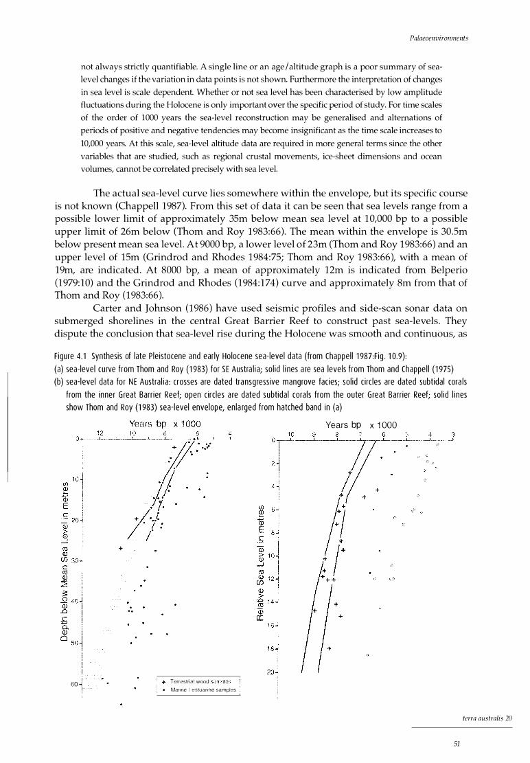
Palaeoenvironments
not always strictly quantifiable. A single line or an age I altitude graph is a poor summary of sea
level changes if the variation in data points is not shown. Furthermore the interpretation of changes
in sea level is scale dependent. Whether or not sea level has been characterised by low amplitude
fluctuations during the Holocene is only important over the specific period of study. For time scales
of the order of 1000 years the sea-level reconstruction may be generalised and alternations of
periods of positive and negative tendencies may become insignificant as the time scale increases to
10,000 years. At this scale, sea-level altitude data are required in more general terms since the other
variables that are studied, such as regional crustal movements, ice-sheet dimensions and ocean
volumes, cannot be correlated precisely with sea level.
The actual sea-level curve lies somewhere within the envelope, but its specific course is not known (Chappell 1987). From this set of data it can be seen that sea levels range from a possible lower limit of approximately 35m below mean sea level at 10,000 bp to a possible upper limit of 26m below (Thom and Roy 1983:66 ). The mean within the envelope is 30.Sm below present mean sea level. At 9000 bp, a lower level of 23m (Thom and Roy 1983:66) and an upper level of 15m (Grindrod and Rhodes 1984:75; Thom and Roy 1983:66), with a mean of 19m, are indicated. At 8000 bp, a mean of approximately 12m is indicated from Belperio (1979:10) and the Grindrod and Rhodes (1984:174) curve and approximately Sm from that of Thom and Roy (1983:66).
Carter and Johnson (1986) have used seismic profiles and side-scan sonar data on submerged shorelines in the central Great Barrier Reef to construct past sea-levels. They dispute the conclusion that sea-level rise during the Holocene was smooth and continuous, as
F igure 4 . 1 Synthesis of late P le istocene and ear ly Ho locene sea- level data (from Chappe l l 1 987:F ig . 1 0.9) : (a) sea- level curve from Thom and Roy (1 983) for SE Austra l i a; so l id l i nes a re sea levels from Thom and Chappe l l (1 975) (b) sea- l evel data fo r N E Austra l i a : crosses a re dated tra nsgress ive mangrove f ac ies; so l id c i rc les are dated subt ida l cora ls
from the i nne r G reat Barr ier Reef; open c i rc les a re dated subtida l cora l s from the outer G reat Barr ier Reef; so l id l i nes show Thom and Roy (1 983) sea- level envelope, en la rged from hatched band in (a)
I 60 -l I
+
. . .
Terrestrial wood • Marine I estuarine samples
Years bp x 1 OOO
() G
terra australis 20
51
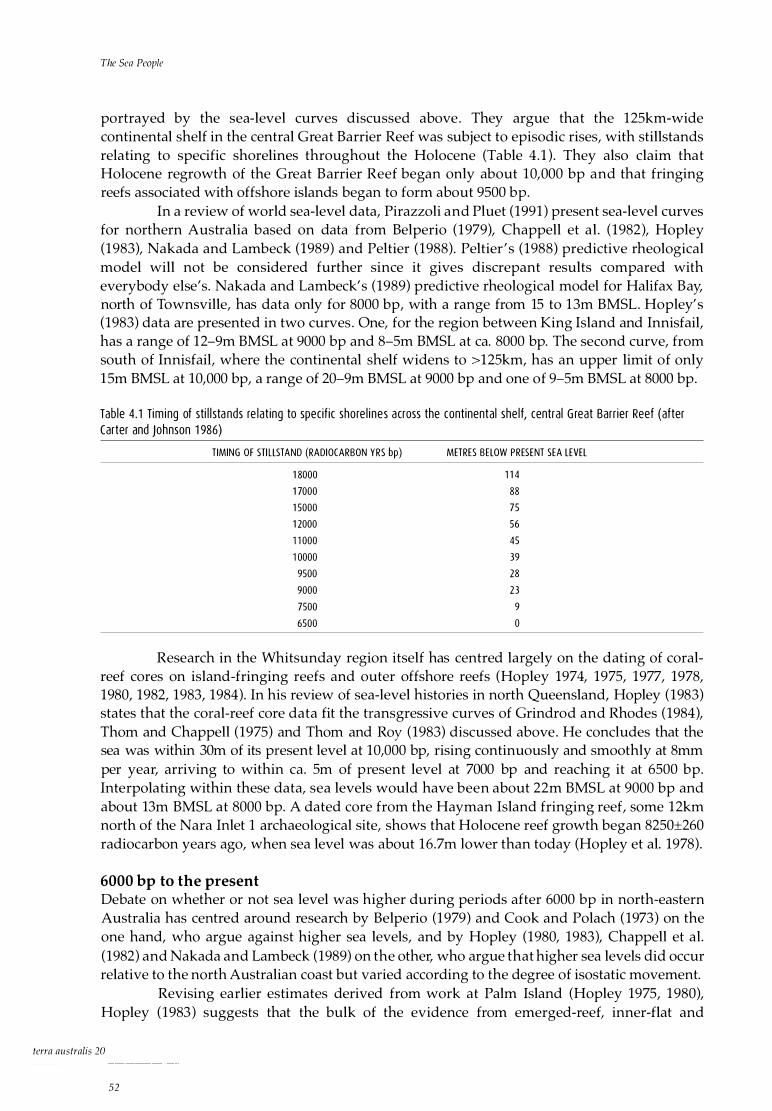
The Sea People
portrayed by the sea-level curves discussed above. They argue that the 125km-wide continental shelf in the central Great Barrier Reef was subject to episodic rises, with stillstands relating to specific shorelines throughout the Holocene (Table 4. 1 ) . They also claim that Holocene regrowth of the Great Barrier Reef began only about 10,000 bp and that fringing reefs associated with offshore islands began to form about 9500 bp.
In a review of world sea-level data, Pirazzoli and Pluet (1991 ) present sea-level curves for northern Australia based on data from Belperio (1979), Chappell et al . (1982), Hopley (1983), Nakada and Lambeck (1989) and Peltier (1988). Peltier ' s (1988) predictive rheological model will not be considered further since it gives discrepant results compared with everybody else's. Nakada and Lambeck's (1989) predictive rheological model for Halifax Bay, north of Townsville, has data only for 8000 bp, with a range from 15 to 13m BMSL. Hopley' s (1983) data are presented in two curves . One, for the region between King Island and Innisfail, has a range of 12-9m BMSL at 9000 bp and 8-Sm BMSL at ea. 8000 bp. The second curve, from south of Innisfail, where the continental shelf widens to > 125km, has an upper limit of only 15m BMSL at 10,000 bp, a range of 20-9m BMSL at 9000 bp and one of 9-Sm BMSL at 8000 bp.
Tab le 4 . 1 Tim ing of sti l l sta nds re lat ing to specif ic shore l ines across the cont inental she l f, central G reat Barr ier Reef (after Carter and Johnson 1 986)
TIMING OF STI LLSTAND (RADIOCARBON YRS bp)
1 8000
1 7000
1 5000
1 2000
1 1 000
1 0000
9500
9000
7500
6500
METRES BELOW PRESENT SEA LEVEL
1 1 4
88
75
56
45
39
28
23
9
0
Research in the Whitsunday region itself has centred largely on the dating of coralreef cores on island-fringing reefs and outer offshore reefs (Hopley 1974, 1975, 1977, 1978, 1980, 1982, 1983, 1984). In his review of sea-level histories in north Queensland, Hopley (1983) states that the coral-reef core data fit the transgressive curves of Grindrod and Rhodes (1984), Thom and Chappell (1975) and Thom and Roy (1983) discussed above. He concludes that the sea was within 30m of its present level at 10,000 bp, rising continuously and smoothly at 8mm per year, arriving to within ea. Sm of present level at 7000 bp and reaching it at 6500 bp. Interpolating within these data, sea levels would have been about 22m BMSL at 9000 bp and about 13m BMSL at 8000 bp. A dated core from the Hayman Island fringing reef, some 12km north of the Nara Inlet 1 archaeological site, shows that Holocene reef growth began 8250±260 radiocarbon years ago, when sea level was about 16.7m lower than today (Hopley et al. 1978).
6000 bp to the present Debate on whether or not sea level was higher during periods after 6000 bp in north-eastern Australia has centred around research by Belperio (1979) and Cook and Polach (1973) on the one hand, who argue against higher sea levels, and by Hopley (1980, 1983), Chappell et al. (1982) and Nakada and Lambeck (1989) on the other, who argue that higher sea levels did occur relative to the north Australian coast but varied according to the degree of isostatic movement.
Revising earlier estimates derived from work at Palm Island (Hopley 1975, 1980), Hopley (1983) suggests that the bulk of the evidence from emerged-reef, inner-flat and
terra australis 20
52

Palaeoenvironments
cemented beach deposits elsewhere indicates a mid-Holocene emergence of between 2.5 and 3m above present sea level. Table 4.2 is a summary of mid- to late-Holocene emergence in tropical Queensland adapted from Hopley ( 1983), who states that there is no evidence for higher sea levels in the whole of the outer Great Barrier Reef or the Whitsunday Islands after 6000 bp. The 1983 estimates of Hopley for mid-Holocene sea level in the Townsville region are 1 .2-1 .7m higher than those of Chappell and colleagues, but otherwise are consistent for sites northwards from Townsville (Chappell et al. 1982, 1983; Chappell 1983). Using the evidence of 45 radiocarbon dates from fringing coral reefs and prograded mangrove shores, Chappell et al. (1983; cf. Chappell 1983) conclude that relative sea level fell smoothly from + 1-1 .3m at 6000 bp to its present position, with no evidence of secondary oscillations (Pirazzoli and Pluet 1991 :21 ). What is apparent once again is that sea-level histories vary throughout the region.
Tab le 4.2 Mid- to late Ho locene emergence in trop ica l Queens land (adapted from Hopley 1 983) .����������������-
LOCATION
Southern Gulf of Carpentaria
Fr inging reefs on is lands and main land, Cape Melvi l l e to Cai rns
High is lands between Cardwel l and Bowen
Whitsunday Is lands
Eastern side of Broad Sound
High is lands of the southern Cumber land Group
Redbi l l Reef ( innermost of the Great Barr ier reefs)
··'' Mean Low Water Spring Tide Level
Discussion
HE IGHT ABOVE PRESENT MLws··''
+3
+ 1 .5
+ 1 .5
0
+6
+ 1 -2
+1
The timing of the Holocene marine transgression in the Whitsunday region is important for some of the major issues of this monograph. I argue below that the timing of initial occupation of the Nara Inlet 1 site around 9800 years ago, based on age I depth extrapolation from a calibrated non-basal date of 9000 BP, marks the arrival of the sea close enough to the site for an already coastally adapted population to continue exploiting local marine resources from there. Local sea-level history is also important when investigating possible changes to the immediate resource base, to technological practices and innovations and to the distribution and intensity of site use and when considering how these may be linked to transgressive I regressive sealevel events during the course of the Holocene (Barker 1989a, 199la, 1993).
Tab le 4.3 Mean sea levels in NE Austra l ia in re lat ion to p resent Mean Low Water Spring Tide Level (MLWS) between 1 0,000, 9000 and 8000 bp (ea . 1 1 ,500, 1 0,000 and 9000 cal BP)
Thom and Roy 1 983 (NSW), G rindrod and Rhodes 1 984, Belperio 1 979
Ca rter and Johnson 1 986
Nakada and Lambeck 1 989
Hop ley 1 983 (centra l Great Barrier Reef)
H op ley 1 983 (Wh itsundays)
1 0,000 BP <MLWS (m) 9000 BP <MLWS (m) 8000 BP <MLWS (m)
35-26
39
30
23-1 5
23
below 1 6
22
1 2-8
1 1
1 5-1 3
9-5
1 3
Based on the available data, sea level around 10,000 years ago, when people first occupied Nara Inlet 1, was about 20m below present (Fig. 4.2). At this time all the large islands of the Whitsundays were still part of the mainland, forming a large peninsula (based on the continental shelf -20m contour, Cumberland Islands and Whitsunday Passage Hydrographic Chart, 1 : 100,000). The Whitsunday Passage was a large drowned valley at this time.
terra australis 20
53
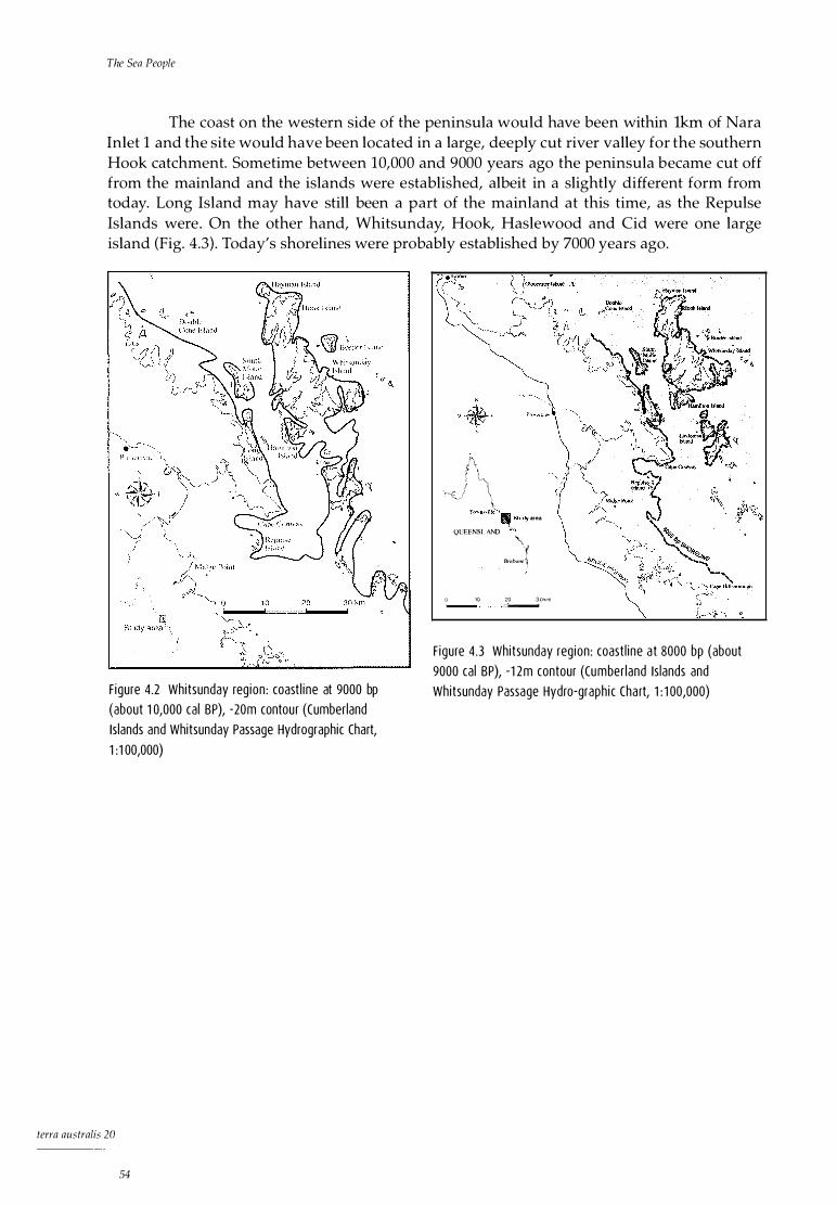
The Sea People
The coast on the western side of the peninsula would have been within lkm of Nara Inlet 1 and the site would have been located in a large, deeply cut river valley for the southern Hook catchment. Sometime between 10,000 and 9000 years ago the peninsula became cut off from the mainland and the islands were established, albeit in a slightly different form from today. Long Island may have still been a part of the mainland at this time, as the Repulse Islands were . On the other hand, Whitsunday, Hook, Haslewood and Cid were one large island (Fig. 4.3 ) . Today's shorelines were probably established by 7000 years ago.
F igure 4.2 Whitsunday reg ion : coast l ine at 9000 bp (about 1 0,000 cal BP), -20m contou r (Cumberland Is lands and Whitsunday Passage Hydrographic Chart, 1 :1 00,000)
terra australis 20
54
{\ ; '-1
',-(_j \ �-fo�nwil!� � Study area
()UEENSI. AND � \..
(l 10
y Bn.!-hane �
20 30km - -"'--
F igure 4 .3 Whitsunday reg ion : coast l ine a t 8000 bp (about 9000 cal BP), -1 2m contour (Cumber land Is lands and Whitsunday Passage Hydro-graph ic Cha rt, 1 : 1 00,000)
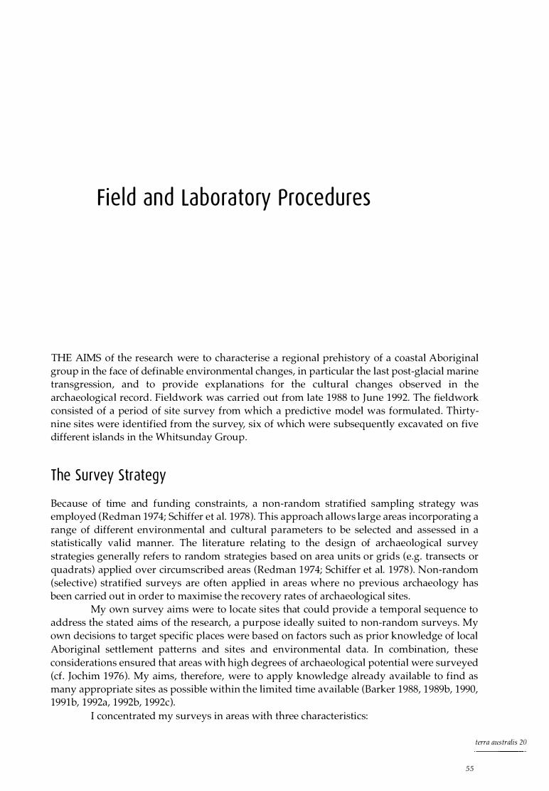
Field and Laboratory Procedures
THE AIMS of the research were to characterise a regional prehistory of a coastal Aboriginal group in the face of definable environmental changes, in particular the last post-glacial marine transgression, and to provide explanations for the cultural changes observed in the archaeologica l record. Fieldwork was carried out from late 1988 to June 1992. The fieldwork consisted of a period of site survey from which a predictive model was formulated. Thirtynine sites were identified from the survey, six of which were subsequently excavated on five different islands in the Whitsunday Group.
The Su rvey Strategy
Because of time and funding constraints, a non-random stratified sampling strategy was employed (Redman 1974; Schiffer et al. 1978). This approach allows large areas incorporating a range of different environmental and cultural parameters to be selected and assessed in a statistically valid manner. The literature relating to the design of archaeological survey strategies generally refers to random strategies based on area units or grids (e.g. transects or quadrats) applied over circumscribed areas (Redman 1 974; Schiffer et al. 1978). Non-random (selective) stratified surveys are often applied in areas where no previous archaeology has been carried out in order to maximise the recovery rates of archaeological sites.
My own survey aims were to locate sites that could provide a temporal sequence to address the stated aims of the research, a purpose ideally suited to non-random surveys. My own decisions to target specific places were based on factors such as prior knowledge of local Aboriginal settlement patterns and sites and environmental data. In combination, these considerations ensured that areas with high degrees of archaeological potential were surveyed (d. Jochim 1976). My aims, therefore, were to apply knowledge already available to find as many appropriate sites as possible within the limited time available (Barker 1988, 1 989b, 1990, 1991b, 1992a, 1992b, 1992c).
I concentrated my surveys in areas with three characteristics:
terra aus tralis 20
55

The Sea People
1 ) high resource potential, that is, areas o f high biomass, such a s mangrove o r fringing-reef systems, and areas of high habitat diversity;
2) topographic suitability for habitation and/or access, including areas of flat ground and / or scarp faces associated with overhangs or caves, the notion of topographic suitability having special significance here because of the extreme precipitousness of much of the landscape, where habitation is physically impossible; and
3) proximity to permanent freshwater.
The surveys Surveys were undertaken in a variety of environmental situations, including the mainland, the mainland coast and the islands. The region was thus stratified into four geographical areas -Hinterland, Protected Bays, Inlets and Exposed Coast - each with three stratified units.
Unit 1 , 100% sample surveyed, consisted of sites already known to local authorities, including Department of Environment and Heritage, Queensland National Parks and Wildlife Service (QNPWS), other archaeological researchers (e.g. Rowland 1986) and local inhabitants. All known sites were either on island coasts or the mainland coastal fringe.
Unit 2, 60% sample surveyed, consisted of areas considered likely to contain a significant proportion of archaeological sites, based on prior knowledge of site locations in the Whitsunday region. These areas included combinations of inlets, sheltered bays, mangrove systems, fringing-reef systems, permanent freshwater sources and areas of flat ground.
Unit 3, 20% sample surveyed, included hinterland regions and areas of coastal fringe (exposed coast) which exhibited none of the features of Unit 2.
The results Within the four geographical areas into which the research region was stratified - Hinterland, Inlets, Protected Bays and Exposed Coast - 34 sample areas were surveyed. Ten of these were located in hinterland areas, defined as the interior of islands or inland areas 500m from the high-water mark (HWM); four in inlets; 1 7 in bays; and three on exposed coasts. Evidence of prehistoric occupation was found in 17 of the 34 areas surveyed.
Of the 39 recorded sites, 58.9% are situated in inlets, 33 .3% in bays and 7 .6% on exposed coast (Table 5 . 1 ) . No sites were found in hinterland areas.
Of all sites, 87. 1 % are associated with a mangrove environment, 82% are near a seasonal freshwater creek and 7 4.3% near fringing reefs .
Table 5 .1 shows that almost half of the sites located are rock shelters, with isolated finds, surface scatters and middens making up the bulk of the rest. The sites are consistently located from 0 to 40m above HWM, with an average elevation of 15m.
Discussion The high proportion of sites found in inlets and bays (Table 5 . 1 ) is significant and consistent with ethnohistoric observations, as noted in Chapter 3. Inlets and bays provide shelter and protection from the elements, as well as a broad range of rich resource zones, each of which supports a high biomass. This is important for a marine-oriented people whose mobility is often affected by such potentially 'random' factors as adverse weather conditions. It is in such environments that people can base themselves for fairly long periods of time, moving out to other, potentially resource-poorer zones when conditions permit. Much of the local hinterland areas on the islands and the adjacent mainland are extraordinarily precipitous and beach-front or rock-platform areas in bays and inlets offer the only practical habitation zone.
The lack of open sites in bays and inlets indicates that there may be an element of site preservation bias in the observed site pattern. Large bays that have all the attributes for large-
terra australis 20
56
Field and Laboratory Procedures
Tab le 5 . 1 Whitsunday reg ion : sites recorded, by geographical zone
H INTERLAND INLETS BAYS EXPOSED COAST TOTAL S ITE TYPES
Rock shelter # 1 5 3 1 8
% 83.3 1 6.6 46.1
Surf ace scatter # 2 5
% 40 60 1 2 .8
Midden # 5 5
O/o 1 00 1 2 .8
Isolated f ind # 6
% 1 6.6 1 6.6 50 1 6.6 1 5 .3
Fish Trap # 2 2
% 1 00 5 . 1
Burial # 1 1
% 1 00 2 .5
Stone # 1
arrangement O/o 1 00 2.5
Qua rry #
% 1 00 2 .5
TOTAL SITES # 23 1 3 3 9
% 5 . 1 59 33 .3 2 .6 1 00
scale and intensive prehistoric use but lack the terrain for rock shelters or overhangs nearly always have evidence of prehistoric visitation. Such evidence, however, is usually ephemeral, consisting of a few scattered artefacts or surface scatters of shell . There is little doubt that inlets and bays were an important element in the settlement / subsistence system. It could be, however, that the dynamic nature of tropical coasts and the destructive properties of tropical wet seasons have militated against the survival of intact open archaeological sites in those zones which lie close to the HWM (see Bird 1992 and Rowland 1992 for a discussion of site destruction in tropical environments) .
Excavat ion Procedu res
It was apparent from the survey that the only sites surviving with any stratigraphic integrity were those in rock shelters. Intact middens were rare, especially those promising a deep sequence. As noted above, this may have as much to do with taphonomic process as with prehistoric cultural processes. Consequently, rock shelters became the focus of attention in the attempt to obtain temporal sequences from the region.
The six sites excavated were selected on the basis of spatial distribution (i.e., on different islands), perceived potential to yield relatively long temporal sequences and physical accessibility (i.e., in locations visited by QNPWS patrol boats).
Because the aim of the research was to establish a temporal framework for the prehistory of the Whitsunday Islands, the methodology adopted in the field and the laboratory was designed to identify and investigate changes in the archaeological record through time.
The sites selected for attention in the light of the above objectives were each excavated in 50 x 50cm squares referenced to an alpha-numeric grid. All excavations followed the Johnson method (Johnson and Jones 1985:31-3) of arbitrary 'bucket' excavation units (XU), usually averaging about 3cm in depth, within 'natural' stratigraphic units (SU). The material removed was sieved through 3mm wire mesh sieves and bulk sediment samples, pH and dry Munsell colour determinations were taken every second excavation unit of each square
terra australis 20
57

The Sea People
excavated. In situ artefacts greater than 2cm maximum dimension were plotted threedimensionally and bagged separately.
A number of factors dictated the size of the excavation area, including the types of research questions being asked, which were temporal rather than spatial in nature and, importantly, the time constraints placed on each excavation. The field research was entirely dependent on the use and availability of QNPWS I Great Barrier Reef Marine Park Authority patrol vessels. The field team would be dropped at the site as part of a regular patrol to the offshore islands and would have to be packed and ready to leave when the patrol returned. Sometimes this gave us as little as five days to do the work. Therefore, in order to maintain a high standard of excavation and data collection, only small test pits were excavated under such circumstances. The largest area excavated was 2m2 at the Nara Inlet 1 rock shelter on Hook Island.
Ana lys is of Cu l tu ra l Materi a l
Once sieved in the field, the archaeological material was bagged for sorting under controlled conditions . In the laboratory the material from each XU was subject to water flotation to remove charcoal and plant material, dried in trays and sorted. As each XU contained a high proportion of small unidentifiable shell fragments mixed with non-cultural sediments, each XU was put through a 4mm sieve just prior to sorting. Only crab shell, identifiable pieces of molluscan shell that could be counted for Minimum Numbers of Individuals (MNI) determination, bone and other non-shell material were removed from the <4mm component. The >4mm component was sorted in its entirety. Identifications of all faunal components were carried out by myself, with reference to the Department of Anthropology and Sociology (University of Queensland) faunal comparative collection, and the assistance of the following specialists from the Queensland Museum: Dr Steve Van Dyke (mammals), Peter Davies (crustaceans and fish), Dr Roly MacKay and Jeff Johnson (fish), Patrick Cooper (reptiles) and Dr John Stanisic (land snails). Plant identifications were carried out by Sinead Melville of the Department of Botany, University of Queensland, and by staff of the Queensland Herbarium.
Methods of quantification Because of the focus on temporal change, quantification of the archaeological material through time was conducted. This was carried out on raw numbers, MNI, numbers of individuals by weight (NIBW) and / or weights of plant and animal taxa deposited per unit of time (e.g., 1000 years). At Nara Inlet 1 (Chapter 6) and Border Island 1 (Chapter 8), discard rates were calculated as 'blocks' between the available calibrated dates. The excavations at Hill Inlet Rock Shelter 1 (Chapter 9) and Nara Inlet Art Site (Chapter 7) have a single, near-basal date only, so relative discard 'rates' were assessed on the single date as the start of the occupation.
For purposes of calculation the end of occupation was taken as 0 BP (1950). The two Nara Inlet sites provided direct evidence of post-contact use with the presence of European artefacts either at the surface or in the upper levels. At Border Island 1 and Hill Inlet Rock Shelter 1, there was no European artefactual material, suggesting that occupation had either ceased prior to contact or was so sporadic in the contact period as to be archaeologically invisible. The surface of these sites, however, was treated as post-dating initial European contact like the other two, based on depositional similarities with them.
Once sorted, animal and plant remains were divided into their respective taxa by XU. The weight of each taxon was recorded and MNI calculated. In order to estimate the total
tcrra australis 20
58
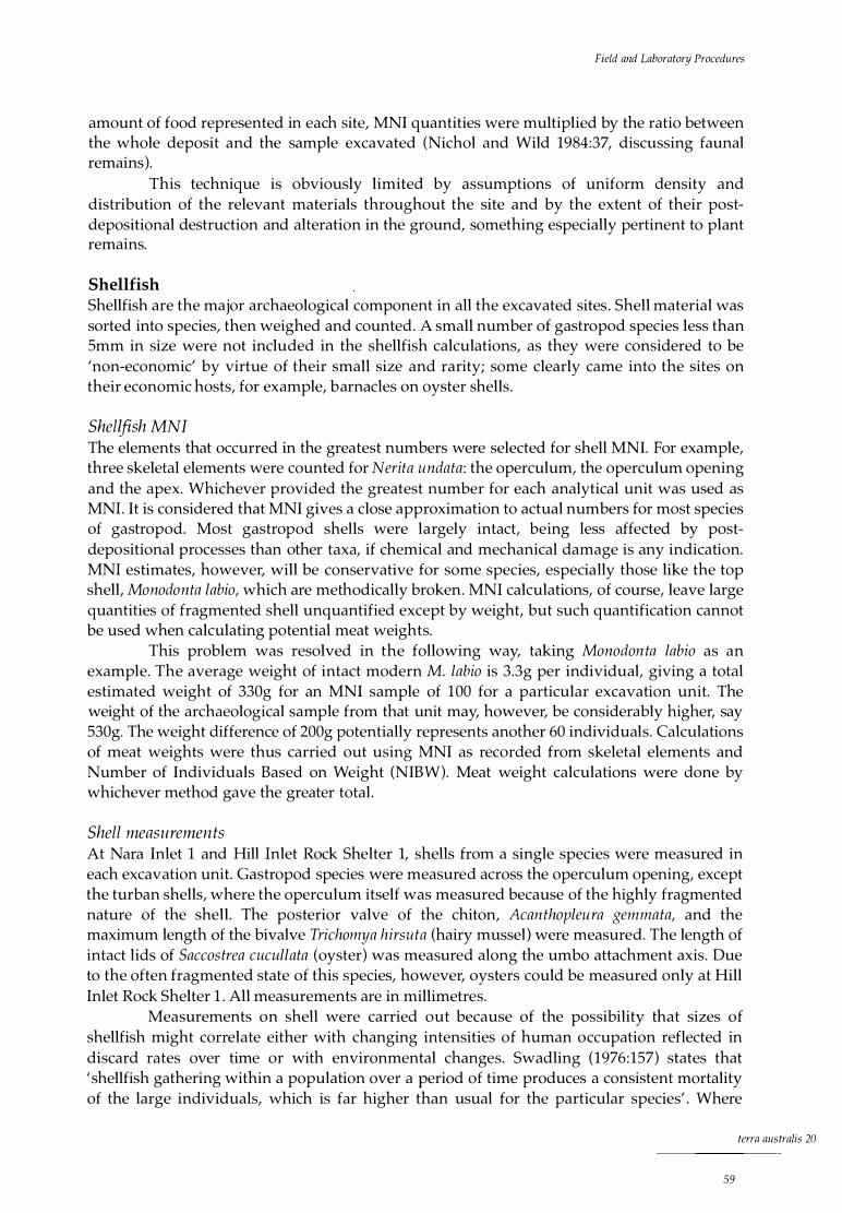
Field and Laboratory Procedures
amount of food represented in each site, MNI quantities were multiplied by the ratio between the whole deposit and the sample excavated (Nichol and Wild 1984:37, discussing faunal remains).
This technique is obviously limited by assumptions of uniform density and distribution of the relevant materials throughout the site and by the extent of their postdepositional destruction and alteration in the ground, something especially pertinent to plant remains.
Shellfish Shellfish are the major archaeological component in all the excavated sites . Shell material was sorted into species, then weighed and counted. A small number of gastropod species less than Smm in size were not included in the shellfish calculations, as they were considered to be 'non-economic' by virtue of their small size and rarity; some clearly came into the sites on their economic hosts, for example, barnacles on oyster shells.
Shellfish MNI The elements that occurred in the greatest numbers were selected for shell MNI. For example, three skeletal elements were counted for Nerita undata: the operculum, the operculum opening and the apex. Whichever provided the greatest number for each analytical unit was used as MNI. It is considered that MNI gives a close approximation to actual numbers for most species of gastropod. Most gastropod shells were largely intact, being less affected by postdepositional processes than other taxa, if chemical and mechanical damage is any indication. MNI estimates, however, will be conservative for some species, especially those like the top shell, Manadanta labia, which are methodically broken. MNI calculations, of course, leave large quantities of fragmented shell unquantified except by weight, but such quantification cannot be used when calculating potential meat weights.
This problem was resolved in the following way, taking Manadan ta labia as an example. The average weight of intact modern M. labia is 3.3g per individual, giving a total estimated weight of 330g for an MNI sample of 100 for a particular excavation unit. The weight of the archaeological sample from that unit may, however, be considerably higher, say 530g. The weight difference of 200g potentially represents another 60 individuals. Calculations of meat weights were thus carried out using MNI as recorded from skeletal elements and Number of Individuals Based on Weight (NIBW). Meat weight calculations were done by whichever method gave the greater total .
Shell measuremen ts At Nara Inlet 1 and Hill Inlet Rock Shelter 1, shells from a single species were measured in each excavation unit. Gastropod species were measured across the operculum opening, except the turban shells, where the operculum itself was measured because of the highly fragmented nature of the shell. The posterior valve of the chiton, Acan thapleu ra gemmata, and the maximum length of the bivalve Trichamya hirsu ta (hairy mussel) were measured. The length of intact lids of Saccastrea cucullata (oyster) was measured along the umbo attachment axis. Due to the often fragmented state of this species, however, oysters could be measured only at Hill Inlet Rock Shelter 1 . All measurements are in millimetres.
Measurements on shell were carried out because of the possibility that sizes of shellfish might correlate either with changing intensities of human occupation reflected in discard rates over time or with environmental changes. Swadling (1976:157) states that ' shellfish gathering within a population over a period of time produces a consistent mortality of the large individuals, which is far higher than usual for the particular species' . Where
terra australis 20
59

The Sea People
environmental changes are implicated, it might be expected that changes in shell size would be more general, affecting many species, including non-economic ones. A modern sample of each of the species represented archaeologically was measured for comparison.
Procedures for meat weights Meat weights were calculated from modern specimens of the following species: Acanthopleura gemmata (chiton), Saccostrea cucullata (oyster), Nerita undata (nerite), Monodonta labia (top shell), Lunella cinerea (turban shell) and Thais kieneri (Table 5.2) . Although sample sizes were generally small (between 20 and 50 individuals), previous research on meat weights of species of similar sizes has given similar results (Meehan 1982). All the shellfish collected were weighed individually and, where possible, the meat was removed and weighed without cooking (chiton had to be placed in the embers of a fire before the valves could be removed). All the shells were then measured for comparison with the archaeological measurements, as noted above. Individuals were selected to comply with the size range indicated from the prehistoric shellfish examples. It is to be noted that the modern individuals of some species, in particular chiton, were of a larger size than the measured prehistoric populations. This may reflect the fact that, with the exception of oyster, none of the shellfish species is exploited in the region today. It is possible that the consistently smaller size of the prehistoric populations reflects sustained extractive pressures on local populations.
Tab le 5 . 2 Meat weights of modern she l l f i sh
SPECIES SAMPLE S IZE TOTAL MEAT WEIGHT (g) AVERAGE MEAT WEIGHT (g)
Nerita undata 20 24 1 .2
Acanthop/eura gemmata 30 646 2 1 .5
Lune/la cinerea 50 78.5 1 . 57
Saccostrea cucullata 24 1 1 5 .6 4.82
Monodonta labia 50 68 1 . 36
Trichomya hirsuta 20 56.4 2.82
Thais kieneri 30 1 02 3 .42
Bone In order to characterise the relative economic importance of various land- and sea-based animals, bone material was sorted initially into terres trial fauna (terrestrial mammals, reptiles and birds) and marine fauna (marine mammals, reptiles and fish). Diagnostic elements were then separated for species identification. Specific identification was carried out on cranial elements such as otoliths and teeth and post-cranial material for turtle. The rest of the bone was separated into categories: terrestrial, fish, marine mammal and marine reptile. Where possible, diagnostic post-cranial bones were also checked for otherwise unrecorded species. All bone was weighed as total bone weight and then by broad categories, such as fish bone, terrestrial bone and so on.
Calculating MNI from bone MNI was calculated on bone from terrestrial and marine fauna, using specific identifiable skeletal elements (mainly cranial in terrestrial fauna). The most numerous right or left identifiable element of each species was used to calculate MNI (White 1953:397). Where size differences between two common left and right elements were obvious, then each would be counted as a separate individual. In addition, if a single macropodid tooth, for example, occurred in isolation at least two XU, or about 6-Scm, from a previously recorded individual, the tooth was counted as a separate individual .
terra australis 20
60
Field and Laboratory Procedures
There is a problem arising from the spatial distribution of different skeletal elements of large animals, as the bones from a single individual may be spread horizontally over many square metres of floor deposit, which makes any MNI extrapolation based on small excavations problematic. This is considered to be particularly the case for marine turtle, sea mammal and macropodid remains, as these are big animals, with the largest number of large bones. Although in some cases the rock wallaby found in the sites is smaller than some fish, it is classified as a 'large animal' because of its different skeletal structure, containing large single bone elements, such as femurs and tibias, which can be scattered.
In the light of the above considerations about large animals, the convention was established that all bone of the same species found within a metre radius in the same XU was counted as belonging to a single individual, unless identifiable bones were present to prove the contrary. Where the units of analysis were excavation squares of only 50 x 50cm, bone from a single XU in such squares was taken as representing an individual per square metre . This could then become so many individuals per cubic metre, depending on the number of XU and the MNI of each of them, subject to the following qualification. This is the convention described in the case of the single macropodid tooth above, that is, counting as belonging to different individuals bone separated by at least two XU. Thus, if there are five individuals in a 50 x 50cm square, counted by convention as representing five per square metre, and they are separated by at least two XU from each other, and if the excavation square is about lm deep, then there are reckoned to be five individuals per cubic metre.
While I am aware of the potential problems of employing this method in regard to the vertical distribution of skeletal elements from a single occurrence, I consider the method valid in the context of the sites analysed for this study because of their high degree of stratigraphic integrity and the little evidence for any downward movement I mixing of cultural material . Furthermore, the MNI obtained are considered to be a more accurate calculation of actual numbers than if MNI were carried out using Stratigraphic Units (SU) as the unit of analysis, since in some cases these span many thousands of years.
In the light of the above consideration of the conventions I have used to arrive at numbers of animals met with in my excavations, and the density of their occurrences, it is important to note that my extrapolations to the whole site are hypothetical. They are used only as a heuristic device in order to arrive at estimated trends so that inter-site comparisons can be made.
MNifor fish Calculation of MNI for fish was carried out on otoliths where these were present. Where not, Number of Identified Specimens (NISP) was not considered as a method because of the amount of time required in allocating skeletal components to taxa. Instead, I made use of vertebrae.
Walters (1987, 1989) and, more recently, Hall and Bowen (1989) have employed a method that equates each fish vertebra with an individual fish. This is based on a taphonomic study conducted on lizard skeletons in the Australian arid zone, which indicated that after six months burial I exposure to the elements, there was a mean rate of survival of only 1 .25 vertebrae per individual (Walters 1987:230). Given that fish have a large number of vertebrae and that they are the most commonly preserved skeletal element in archaeological sites, it is thought that this method will result in a considerable over-estimate of MNI, bringing into doubt conclusions about faunal representations. I would therefore argue that Walters' (1987) and Hall's and Bowen's (1989) calculations may have erred considerably with respect to faunal representations, dietary breadths and reconstructed resource structures.
In order to avoid this problem, I employed two methods of analysis for fish vertebrae. The first involves the division of the total number of vertebrae in each XU, square or
terra australis 20
61

The Sea People
site by the number of possible vertebrae per individual, thus giving an estimation of MNI. Because the number of vertebrae present in any single species is determined by inheritance and environment (Rojo 1991 ), it is important to know the variability in the number of vertebrae present in any single species when using this method. For example, if a species has a maximum of 37 vertebrae and there are 400 vertebrae in a square, there will be an MNI of 11 individuals. There can be no doubt that this method errs on the side of conservatism and will thus often under-represent each taxon, but I argue that it is likely to produce more accurate and useable results than the method proposed by Walters.
By its very nature, MNI is a conservative measure. Because of this, a refinement was applied by taking into account the size range of fish vertebrae when calculating MNI. This was determined by measuring the centra, or central portion, of the vertebrae of individual species, using samples of fish of the same kinds that had been excavated in the archaeological sites. In some species, for example, differences between vertebrae sizes in a single individual may average 6mm. If any two vertebrae, out of all the vertebrae for that species detected within two XU, have a size difference greater than 6mm, they are considered to have come from separate individuals.
Burn t and calcined bone In an attempt to identify possible taphonomic processes affecting preservation, burnt and calcined bone was quantified. It could reasonably be expected that high percentages of burnt / calcined bone would correlate with a high charcoal weight in the same excavation unit. Evidence for more intensive burning, for example, in relation to fireplaces would expectably go hand in hand with a higher attrition rate of bone, especially of small fragile material such as fish bone.
Plant material Relatively large quantities of plant material were recovered from the sites, especially Nara Inlet 1, including seeds, husks, leaves, bark, wood, flowers, grass and roots. Plant material is notoriously hard to quantify, so presence or absence of taxa only is indicated for each XU. Vegetable foods are likely to have been a very important resource (see Chapter 3) which, however, is grossly under-represented in the archaeological remains. Apart from insights into subsistence systems, the study of plant remains may also reveal palaeoenvironmental information and clues as to seasonality of occupation. I will return to these points at various times in the individual site reports .
Land snails Land snails are often attracted to rock shelters as a result of their greater levels of humidity, a protection against desiccation, and, in some circumstances, to obtain calcium carbonate for shell growth. Hence it is likely that most, if not all, land snail shells found in the excavations are natural, although it is recognised that the occurrence of some species, especially Bentosites macleayi, a large vine-thicket snail, may have had cultural origins. Weights of snail shells per XU were recorded and the habitats of each taxon noted in order to obtain environmental information.
terra australis 20
62
Field and Laboratory Procedures
Stone artefacts A simple problem-orientated technological analysis was carried out on some of the stone material . This was done in order to determine whether changes to subsistence and settlement systems, apparent in other aspects of the archaeological record, had technological correlates and to establish the spatial patterning of raw materials of known provenance.
Technological attributes recorded for each artefact included: weight, artefact type, raw material type, length, width and breadth (oriented to maximum measurement), fracture type (flake, broken flake, retouched flake, flaked piece, core), decortication stage (primary, secondary, tertiary), presence or absence of platform preparation (overhang removal, facetting), termination type (feather, hinge, step, snap, ou trepasse) and the presence or absence of edge damage (retouch I use-wear).
The changing characteristics of stone artefacts in the deposits are assumed to reflect changes in their use, availability and procurement from a small number of known and highly localised sources. This is an issue taken up in Chapter 10 .
terra australis 20
63


Nara Inlet 1 , Hook Island
Reg iona l Descr i pt ion
Hook Island, with a total land area o f 5184 hectares, is the second-largest island in the Cumberland Group (Fig. 6 .1 ) . It is rugged, mountainous and steep-sided, with two large, deeply cut, fiord-like, drowned river valleys, Nara and Macona Inlets, in the south. There are large sheltered bays in the east (Mackerel Bay and Saba Bay) and north (Butterfly Bay). The island is 13km long by 6km wide, with a coastline approximately 80km in length.
The island vegetation is dominated by a mixture of tall closed forest, simple notophyll vine forest and areas of Eucalyptus-dominated open forest, the latter including E. acmenioides, E. drepanophylla, Tris tania conferta, E. tereticornis and E. alba. Smaller areas of Casuarina littoralis, Acacia and mangroves are also present, as are Xan thorrhoea, Pandanus and Cycas in discrete groves .
Nara Inlet, located in the south-west of the island, is 5km long and 700m at its widest and has 12km of coastline within its confines. The shores of the inlet are mostly precipitous, with little or no beach fringe (Plate 6 . 1 ) . Apart from rock shelters and a thin coastal strip at low tide, there are no flat habitation areas in the whole inlet. Three small areas of mangrove are present: in Refuge Bay on the eastern side of the inlet, in a small bay on the western side (about 2km from the head) and at the very head of the inlet itself. These mangroves are all located at the entrance of seasonal creeks and are a product of sedimentation regimes attributable to inland catchment run-off. Much of the surface area of the inlet is so precipitous or thinly soiled that bare rock often predominates over vegetation. Otherwise, thick vine forest dominates, with hoop pine (Araucaria cun ninghamii), Xan thorrhoea, Cycas and Pandanus all present. A l Om-wide fringing reef stretches around the shore of most of the inlet and narrow rock platforms are exposed at low tide in some places.
terra australis 20
65

The Sea People
Cl
F igure 6 . 1 Hook Is land
WHayman
Island
0
Plate 6 . 1 Na ra I n let, Hook Is land, from north-east ( Co lfe lt 1 987)
Nara I n l et 1
N
t
Measuring some 15 x Sm, Nara Inlet 1 is a two-chambered shelter with an easterly aspect, located 20m above the high-water mark (Plate 6.2) . The site has approximately 22m3 of cultural deposit, with a large midden mound at its centre . A total of 1 .5m2 was excavat
.ed
during two field seasons (Fig. 6.2) . The 1988 excavation of two 50 x SOcm squares (GSO and HSO) was located on the
highest part of the floor deposit, some 30 cm from the rear wall. The 1989 excavation was of four 50 x 50cm squares QSO, J51, KSO, LSO). These squares were again located on the highest part of the deposit, but this time 2m from the back wall. No stone artefacts were observed on the
terra australis 20
66

Nara Inlet 1, Hook Island
0- 850 � 0 - Nso � Jso-Er- J s1 K 5o-L so-
F igure 6.2 Nara In let 1 : site map
' '
\ \
\
CULTURAi DEPOSIT \
-OllPLIME
I '
,
, '
Plate 6 .2 Nara I n l et 1 rock shelter
surface, although shell debris, fish bone, plant remains and goat faeces were evident. Actual cultural deposit in Nara Inlet 1 covers about 58m2• It is of varying depths, ranging from an area of 12m2 that is approximately lm in depth to places that are only a few centimetres deep.
Stratigraphic description All the excavated pits displayed four main stratigraphic units as follows (Fig. 6.3).
Stratigraphic Unit 1 (S Ul ), comprising the uppermost levels (XUl -5), consisted of extremely fine, loose, grey sediment some lOcm thick. The layer contained cultural material, including paperbark, nuts, seeds and fibre netting. It also showed evidence of post-European disturbance: goat droppings were found in every excavation unit (XU) above XUS (8cm depth). The absence of goat droppings below XUS attests to the integrity of the lower layers.
Stratigraph ic Unit 2 (SU2), lying between XU6 and 31 inclusive, was a red-brown sediment, greasy in texture and consisting of more compacted sediment than SUl . It was characterised by numerous lenses of white ash, abundant charcoal and a high density of cultural material in the form of shellfish, fish and plant remains.
Stratigraphic Unit 3 (S U3), the lowermost cultural unit, XU32-45 inclusive, began at a depth of 49cm below the ground surface at its highest point. It was characterised by a change of colour to brown, with less abund ant charcoal, fewer ashy layers and a decrease in shellfish remains relative to SU2.
Stratigraphic Unit 4 (SU4), XU45-52 inclusive, began at 96cm below the ground surface at its highest point. It was characterised by a green gravel of the same material as the geological bedrock. Apart from XU46 and 47 near the top, SU4 was culturally sterile and rested on bedrock.
This stratigraphy was uniform in all six squares.
Chronology Four radiocarbon dates have been obtained for Nara Inlet 1 (Table 6 .1 ; see Fig. 6.3). All are on charcoal. Beta 27835 and Beta 31741 are spot dates on discrete pieces of charcoal . These in situ pieces were plotted three-dimensionally and bagged on site. The other two dates come from charcoal from XU28 and XU35 extracted from the sieves.
terra australis 20
67

The Sea People
cm HSO EAST o ------... SU H50 SOUTH G50 SOUTH
1 0
20
30 I I
40 2090+-50 Beta 281 88
3990+-60 Beta 31 742
80 I l l 90
81 50+-80 Beta 27835
1 00
1 1 0 sterile IV
1 20
1 30 bedrock bedrock
1 40 ll!charcoal/ashy layer []shell
F igure 6.3 Na ra In le t 1 : stratig raph ic sections
Ta b le 6 . 1 Na ra In let 1 : rad iocarbon dates
LAB NO SU XU D EPTH cm 1 4( bp CAL BP'''
Beta 3 1 741 1 3 1 5 550±70 650(520)340
Beta 281 88 2 28 46-49 2090±50 2 1 30(1 990) 1 880
Beta 31 743 3 35 63-66 3990±60 4530(441 0)41 60
Beta 2 7835 3 45 95 8 1 50±80 9250(8990)8670
'''Stuiver and Reimer 1 993
Beta 27835 is a non-basal date from SU3. It was obtained from a discrete concentration of charcoal just above the interface of SU3 and SU4 at 95cm in the eastern section of Square H50. This is, however, 14cm above the lowest cultural material, which lay at the interface between SU3 (cultural) and SU4 (pre-cultural) in the southern section of Square H50. Beta 31743 comes from XU35 between 63 and 66cm, the top of which is 14cm below the interface of SU3 and SU2. Beta 28188 is from XU28 between 46 and 49cm, the bottom of which is l Ocm above the interface of SU3 and SU2 in the southern section of Square G50. Beta 31741 dates a discrete concentration of charcoal at the top of SU2 at 15cm depth. All dates in the text below are calibrated.
Calculations of sedimentation rates over time, employing the central values of the calibrated ages, are given in Figure 6.4 below. This shows a five-fold increase after 1990 BP and a further increase after 520 BP. European artefactual material found in the upper units of Square K50, as well as in the 1 5cm of cultural deposit post-dating 520 BP in Square G50, is evidence of the site's post-contact Aboriginal use.
Cultural phases It should be noted that the dates of 4410 BP and 1990 BP are on either side of the major stratigraphic break separating an early phase of occupation, Phase 1 , from a later one, Phase 2.
terra australis 20
68

Nara Inlet 1, Hook Island
Phase 1 encompasses SU3, while Phase 2 encompasses SUl and 2. The 14cm of deposit separating the two dates, calculated from the bottom of XU28 at 49cm and the top of XU35 at 63cm, represents 2421 years (lcm = 1 72.9 years). This would, hypothetically, date the Phase 1 I Phase 2 transition at the stratigraphic change to 3027 BP, calculated from the mean depth of the stratigraphic change in XU31 as 55cm. However, as actual dates have not been obtained at the stratigraphic change, the upper phase (Phase 2) is taken to begin at 1990 BP. It is recognised that taking 1990 BP as the beginning of Phase 2 and the end of Phase 1 will reduce the concentration index for the lower phase and magnify it for the upper phase, but this is considered a better option than quantifying discard from a hypothetical date . We may note in addition that in the case of charcoal, for example, the pattern of discard in Squares GSO, HSO and JSO combined, calculated between 4410 and the hypothetical 3027 BP in Phase 1 and between 3027 and 1990 BP in Phase 2, is similar to that based on the actual dates as shown in Figure 6.21, the rates per 1000 years being in the first case 488.4g and 2560.7g and in the second 920.2g and 3311 .7g.
The stratigraphic boundary between Phase 1 and Phase 2 marks a major change in sedimentation and deposition rates, among a range of other changes discussed below.
Ana lys is of Cu l tu ra l Materi a l
Analysis of cultural material in Nara Inlet 1 was carried out on three 50 x SOcm squares, GSO, HSO and JSO, totalling 0 .75m3 of deposit.
Shellfish A range of shellfish remains were present in the site, including the rock-platform gastropod, chiton and bivalve species, Nerita undata, Manadan ta labia, Acanthapleura gemmata, Saccastrea cucullata, Trichamya hirsu ta, Lunella cinerea, Thais kieneri and the less abundant Melina ephippium, Pinctada fucata, Asaphis deflarata and Gelaina caaxans .
The discard rate for each taxon was calculated for each dated block. Total shell discard is shown in Figure 6.5, demonstrating a clear and substantial increase in discard rates in Phase 2. This general quantitative change reflects continuity in the relative importance of each taxon through time. Rock-platform species predominate in all levels, with the most common being Nerita undata, Acanthapleura gemmata and Manadanta labia.
Nerite Nerita undata is a small (25mm) rockplatform gastropod which feeds on algae from the rock surface . It is found mainly in areas of volcanic origin in the intertidal zone (Coleman 1982). The species is prolific in the region today, is easily obtainable and represents a
---+-- _ _ _J 0-520
-Cl.... 520-1 990 co
"' -Q.I >- 1 990-4410
441 0-8990 -
1 0 __l__
J J
cm/1 000yrs 1 5 2 0 l ____L_
F igu re 6 .4 Na ra I n l et 1 : sed imentat ion rates
0-520
� 520-1 990 "' � 1 990-44 10
441 0-8990
g/1000yrs 0 5000 1 0,000 1 5,000 --L----�---�-
F igu re 6 .5 Na ra I n l et 1 : d i scard of she l l , g/1 OOOyrs
25 ___J__
J
20,000
30 35 I _ J
]
terra australis 20
69

a.. o::i
ru Cl.I
>-
The Sea People
densely packed resource (densities of living nerites have been calculated at more than 30 per m2 in some areas). It is present throughout the sequence in all squares excavated. Although Square J50 has significantly greater quantities, especially in the upper phase (Phase 2), all the squares follow a similar pattern of discard through time. There is a marked increase in discard rates with the beginning of Phase 2 and a further increase after 520 BP (Fig. 6.6 ). This is followed by a recent decrease in discard after XU5, coincident with the post-contact period as indicated by the presence of glass and goat faeces .
Nerita undata is a shell which survives relatively intact archaeologically and there was an MNI total of 2041 in the three squares analysed (Table 6.2) . Since a modern shell of the species weighs on average 3 .lg, the MNI total translates into a shell weight of 6327. lg. The total weight of shell from the three analysed squares, however, was 7980.3g (Table 6.2), meaning that there were 1 635.2g of shell not accounted for by the MNI estimate . This is equivalent to a further 533 individuals. Figure 6.7 shows that N. undata declines in size over time, throughout Phase 2.
Based on an average meat weight per individual of 1 .2g (Table 5.2), Table 6.2 shows the total meat weight for the three analysed squares to be 3088.8g calculated on the Number of Individuals Based on Weight (NIBW) and gives the meat weight potentially represented in the entire deposit. There is a four-fold increase from Phase 1 to Phase 2.
Tab le 6.2 Nara I n let 1 : she l l weight, MN I, N I BW and meat weight data for Nerita undata
SQUARE TOTAL SHELL WEIGHT
G50 2396.3
H50 2252 . 1
J50 3331 .9
TOTAL 7980.3
/m3
/22m3
NIBW: Number of Individuals Based on Weight
0-520
520-1 990
1 990-441 0
44 10-8990
200 400 MN l/1 000yrs
600 800
MN I (#) 487
503
1 051
2041
272 1 .3
59869.3
1 000 __ L _
Nmw··'' (#)
773
726
1 075
2574
3432
75504
1 200
TOTAL MEAT WEIGHT (g)
927.6
871 .2
1 290.0
3088.8
41 1 8.4
90604.8
Top shell
1 400 I
MEAT WEI GHT MEAT WEIGHT PHASE 1 (g) PHASE 2 (g)
86.7 840.9
1 34 .6 736 .6
423.4 866.6
644.7 2444.1
859.6 3258.8
1 891 1 . 2 71 693.6
F igure 6 .6 Nara I n let 1 : d iscard of Neri ta undata, MNl/1 OOOyrs
The top shell, Monodon ta labia, is found throughout the sequence in all analysed squares and in similar numbers to chiton. A total MNI of 1023 individuals was counted. The species is present in very small quantities in the earlier part of Phase 1 (between 9000 BP and 4410 BP), increasing slightly between 4410 BP and 1990 BP and markedly after 1990 BP in Phase 2 (Fig. 6.8) . Discard rates remain relatively constant throughout Phase 2 in Squares G50 and H50, but increase significantly after 520 BP in Square J50.
26 -24 22
E 20 E 18
1 6 1 4
1 2 ---+------,������I �l��l��,��----,-1 ��1 -��l ��I �.I 1 1 1 3 1 5 17 1 9 21 23 25 27 29
XU
F igure 6.7 Nara I n let 1 : average she l l s ize of Nerita undata by excavat ion un i t
terra australis 20
70
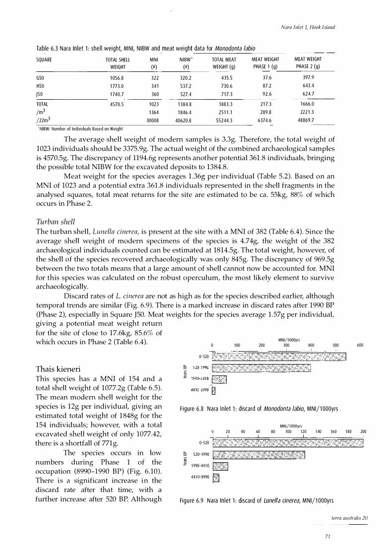
Nara Inlet 1, Hook Island
Table 6 .3 Nara In let 1 : she l l weight, MN I, N I BW and meat weight data for Manadanta labia
SQUARE TOTAL SHELL MN I N I BW''' TOTAL MEAT MEAT WEIGHT MEAT WEIGHT
WEIGHT (#) (#) WEIGHT (g) PHASE 1 (g) PHASE 2 (g)
G50 1 056.8 322 320.2 435.5 37.6 397.9
H50 1 773.0 341 537.2 730.6 87.2 643 .4
J50 1 740.7 360 527.4 7 1 7 .3 92 .6 624 .7
TOTAL 4570.5 1 023 1 384.8 1 883 .3 21 7.3 1 666.0
/m3 1 364 1 846.4 251 1 . 1 289.8 222 1 .3
/22m3 30008 40620.8 55244.3 6374.6 48869.7
" 'N IBW: Number of Individuals Based on Weight
The average shell weight of modern samples is 3.3g. Therefore, the total weight of 1023 individuals should be 3375.9g. The actual weight of the combined archaeological samples is 4570.5g. The discrepancy of 1194.6g represents another potential 361 .8 individuals, bringing the possible total NIBW for the excavated deposits to 1384.8.
Meat weight for the species averages 1 .36g per· individual (Table 5 .2) . Based on an MNI of 1023 and a potential extra 361 .8 individuals represented in the shell fragments in the analysed squares, total meat returns for the site are estimated to be ea . 55kg, 88% of which occurs in Phase 2.
Turban shell The turban shell, Lunella cinerea, is present at the site with a MNI of 382 (Table 6.4) . Since the average shell weight of modern specimens of the species is 4.74g, the weight of the 382 archaeological individuals counted can be estimated at 1814.5g. The total weight, however, of the shell of the species recovered archaeologically was only 845g. The discrepancy of 969 .Sg between the two totals means that a large amount of shell cannot now be accounted for. MNI for this species was calculated on the robust operculum, the most likely element to survive archaeologically.
Discard rates of L. cinerea are not as high as for the species described earlier, although temporal trends are similar (Fig. 6.9) . There is a marked increase in discard rates after 1990 BP (Phase 2), especially in Square J50. Meat weights for the species average 1 .57g per individual, giving a potential meat weight return for the site of close to 1 7.6kg, 85.6% of which occurs in Phase 2 (Table 6 .4).
Thais kieneri
MNl/1 000yrs 0 100 200 300 400 500
o-520 t,.....c ___ · 1 ___ _L_ ______ _____J______ __ · __ ____l_ _ __.
: 1 :::::::-l2_
· . . . .. · .
·
.
441 0-8990-n F igure 6 .8 Na ra I n let 1 : d iscard of Manadanta labia, MNl/1 OOOyrs
MNl/1 OOOyrs
600
This species has a MNI of 154 and a total shell weight of 1077.2g (Table 6 .5) . The mean modern shell weight for the species is 12g per individual, giving an estimated total weight of 1 848g for the 154 individuals; however, with a total excavated shell weight of only 1077.42, there is a shortfall of 771g.
20 40 -+---�-_____L__
60 80 100 1 20 1 40 160 1 80 200
The species occurs in low numbers during Phase 1 of the occupation (8990-1990 BP) (Fig. 6 .10) . There is a significant increase in the discard rate after that time, with a further increase after 520 BP. Although
· ·--_J_-�_L____J 0-520
a... 520-1 990 co
"' � 1 990-441 0
441 0-8990
Fig u re 6.9 Na ra I n l et 1 : disca rd of Lune/la cinerea, MNl/1 OOOyrs
terra australis 20
71
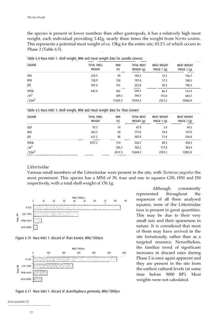
0.. CD
"" �
The Sea People
the species is present in lower numbers than other gastropods, it has a relatively high meat weight, each individual providing 3.42g, nearly three times the weight from Nerita undata . This represents a potential meat weight of ea . 15kg for the entire site, 83.2% of which occurs in Phase 2 (Table 6.5) .
Tab le 6.4 Na ra I n let 1 : she l l weight, MNI and meat weight data for Lune/la cinerea
SQUARE TOTAL SHELL MN I TOTAL MEAT MEAT WEIGHT MEAT WEIGHT WE IGHT (#) WEIGHT (g) PHASE 1 (g) PHASE 2 (g)
G50 224.5 95 1 49.2 1 2 .5 1 36.7 H50 1 58 .9 1 26 1 97.8 1 7.3 1 80.5
J50 461 .6 1 61 252.8 56.5 1 96.3
TOTAL 845.0 382 599.7 86.3 5 1 3 .4
/m3 509.3 799.7 1 1 5 .0 684.7
/22m3 1 1 205.3 1 7592.4 253 1 .5 1 5060.9
Tab le 6.5 Na ra I n let 1 : she l l weight, MN I and meat weight data for Thais kieneri
SQUARE TOTAL SHELL MNI TOTAL MEAT MEAT WEIGHT MEAT WEIGHT WEIGHT (#) WEIGHT (g) PHASE 1 (g) PHASE 2 (g)
G50 93 .5 1 4 47.9 3.4 44.5
H50 362.5 50 1 71 .0 34.0 1 37.0
J50 621 .2 90 307.8 5 1 .0 256.8
TOTAL 1 077.2 1 54 526.7 88.4 438.3
/m3 205.3 702.2 1 1 7.8 584.4
/22m3 451 7.3 1 5449.3 2593.5 1 2855.8
Littorinidae Various small members of the Littorinidae were present in the site, with Tectarius pagodus the most prominent. This species has a MNI of 39, four and one in squares G50, H50 and J50 respectively, with a total shell weight of 1 76 . lg.
Although consistently
MNl/1 000yrs 10 20 3 0 40 50 60 70 80 90
_ ___ J___ _l _ --- _ _ L __ _ _ _ J _
0-520
520-1 990
1 9 90-441 0
441 0-8990
F igure 6 . 1 o Nara In let 1 : d iscard of Thais kieneri, MNl/1 OOOyrs
represented throughout the sequences of all three analysed squares, none of the Littorinidae taxa is present in great quantities. This may be due to their very small size and their sparseness in nature . It is considered that most of them may have arrived in the site fortuitously, rather than as a targeted resource. Nevertheless, the familiar trend of significant increases in discard rates during Phase 2 is once again apparent and they are present in the site from the earliest cultural levels (at some time before 9000 BP). Meat weights were not calculated.
MN 1/1 oooyrs
0 1 00 200 300 400 500 600
0-520
l _ _ ____ _ J __ __i_ _ ___ L _ _ - -- L _ _ _______ L --- --- - - _J
i 1:::_:::: +=_. 4 4 1 0-8990 p
F igure 6.1 1 Na ra I n let 1 : d iscard of Acanthopleura gemmata, MN l/1 000yrs
terra australis 20
72

Nara Inlet 1, Hook Island
Chi ton The chiton, Acanthopleura gemmata, is a large rock-platform species of the intertidal zone common in Nara Inlet today, which grows to a maximum length of lOOmm. It is present in every XU of each analysed square, with a total overall MNI of 1088 and a total shell weight of 7845.7g (Table 6.6). As was the case with nerites, discard rates of chiton are relatively low until 1990 BP, that is, during Phase 1 . Substantial increases in discard rates occur in Phase 2, after 1990 BP and again after 520 BP (Fig. 6. 11 ).
The average shell weight for modern chitons is 19g per individual. On this basis, the weight of the MNI total of 1088 shells would be 20,672g. As the actual shell weight of all archaeological chiton is 7845.7g, the discrepancy in weight of 12,826.3g shows that considerable quantities of chiton shell are missing from the assemblage.
Tab le 6 .6 Nara In let 1 : she l l weight, MN I and meat weight data for Acanthopleura gemmata
SQUARE TOTAL SHELL MN I TOTAL MEAT MEAT WEIGHT MEAT WEIGHT WEIGHT (#} WEIGHT (g) PHASE 1 (g) PHASE 2 (g)
G50 1 940.4 249 5353 .5 1 397.5 3956.0
H50 2424.4 303 651 4 .5 989.0 5525 .5
J50 3480.9 536 1 1 524.0 3934.5 7589.5
TOTAL 7845.7 1 088 23392.0 632 1 .0 1 7071 .0
/m3 1 450 .7 3 1 1 89.3 8428.0 22761 .3
/22m3 3 1 91 4.7 6861 65.3 1 8541 6.2 500749.1
The element on which MNI was calculated for this species was the posterior valve. This is the dense, robust end valve, the most likely to survive of all the eight valves. Given the high survival rate of the posterior valve, it can be hypothesised that post-depositional factors such as burning may have been responsible for the destruction of the less robust median valves. This would account for the discrepancy between the expected and actual weights for this species.
Relative to other shellfish, meat weights for chitons are high, averaging 21 .5g per individual (Table 5.2) . Table 6.6 shows a total meat weight potential in the site of just more than 680kg, 73% of which occurs in the upper phase (Phase 2).
Oyster Saccostrea cucullata is a rock-platform bivalve with a maximum shell size of 80mm which lives in a variety of habitats but favours mangroves, mudflats and rocky reefs . It is extant in the region today, found mainly on rocks in the intertidal zone. Archaeologically, it is present at Nara Inlet 1 from the time of its initial occupation (>9000 BP) and is consistently represented in the sequence.
Tab le 6.7 Na ra I n let 1 : she l l weight, MN I and meat weight data for Saccostrea cucullata
SQUARE TOTAL SHELL MN I TOTAL MEAT MEAT WEIGHT MEAT WEIGHT WEIGHT (#} WEIGHT (g) PHASE 1 (g) PHASE 2 (g)
G50 2564.0 2 1 1 1 0 1 7.0 21 6.9 800.1
H50 2 1 78.2 21 3 1 026.7 236.2 790.5
J50 32 1 8 .2 287 1 383.3 501 .2 882 . 1
TOTAL 7960.4 7 1 1 3427.0 954.3 2472.7
/m3 948 4569.4 1 272 .5 3296.9
/22m3 20856 1 00525.9 27993.8 7253 1 .2
terra australis 20
73

Tlze Sea People
Discard rates remain relatively constant in all squares until 1990 BP, after which they increase dramatically (Fig. 6. 12) . Another significant rise occurs after 520 BP. Once again, discard rates peak in Square J50, especially during Phase 2.
Meat weights for modern oysters average 4.82g (Table 5 .2), which, on the basis of an MNI of 711 from the analysed squares, gives a return of nearly lOlkg of meat for the entire site, 72 . 15% of which falls in Phase 2 (Table 6 .7).
Mussel Trichomya hirsu ta, the hairy mussel, is a small bivalve averaging 50mm, found in clumps on mudflats and muddy bottoms or on rocky reefs, usually in silty areas (Coleman 1982). It is present in all squares throughout the sequence, with a total MNI of 507 and a total shell weight of 2761g. Discard rates are very low throughout Phase 1, increasing significantly after 1990 BP and with a further marked increase after 520 BP (Fig. 6 .13).
Meat weights for modern hairy mussels average 2.82g per individual (Table 5.2). This represents a potential meat return for the site of ea. 42kg, 95% of which occurs in Phase 2 (Table 6.8) . Meat returns increase from 0.3kg per 1000 years in Phase 1 to 20.9kg per 1000 years in Phase 2.
Tab le 6.8 Na ra I n l et 1 : she l l weight, MN I and meat weight data for Trichomya hirsuta
SQUARE TOTAL SHELL MNI TOTAL MEAT MEAT WE IGHT MEAT WEIGHT WEIGHT (#) WEIGHT (g) PHASE 1 (g) PHASE 2 (g)
G50 1 273.7 2 1 7 61 1 .9 1 4 . 1 597.8
H50 802.6 1 50 423.0 3 1 . 1 391 .9
J50 684.7 1 40 394.8 25 .4 369.4
TOTAL 276 1 .0 507 1 429.7 70.6 1 359.1
/m3 676 1 906.3 94.1 1 81 2 .2
/22m3 1 4872 41 939.0 2071 .0 39868.0
Other bivalves
MNl/1 OOOyrs
0 5 0 1 00 1 5 0 200 250 300 350 400 -c-�'- ____ l_ __ ----- -- L __ _ __ _ L ____ _;__ _ _ _ _ l - --- _ ___I__ _ __ _
I
F igure 6 . 1 2 Nara I n let 1 : di sca rd of Saffostrea cucu/lata, MNl/1 OOOyrs
Other bivalves present in the site are Pinctada fucata (pearl shell) and Melina eph ippium. The former attains a maximum size of 85mm and is found in estuaries in a muddy environment, usually attached to clumps of dead shells or sea grass. The latter, similar to pearl shell in shape but distinguished by its hinge teeth (umbo) and attaining a maximum size of 140mm, prefers mangrove habitats and upper tidal inlets, where it attaches in clumps to mangrove roots . The MNI total for P fucata is 145 and for M. ephippium 150 (Table 6. 9 ) . Pearl shell is not present at the site until 4410 BP, but M. ephippium is
50
0-520
0.... 520-1 990 co
"' {;!. 1 990-441 0
441 0-8990
1 0 0 MNl/1 000yrs
1 50 200 250 300 350 400 l_____ � ______ _ J__ ____ _j_ _ _ _ _J - -- ___ __ l __ ____ J
F igure 6 . 1 3 Na ra I n let 1 : d iscard of Trichomya hirsuta, MN l/1 OOOyrs
terra australis 20
74
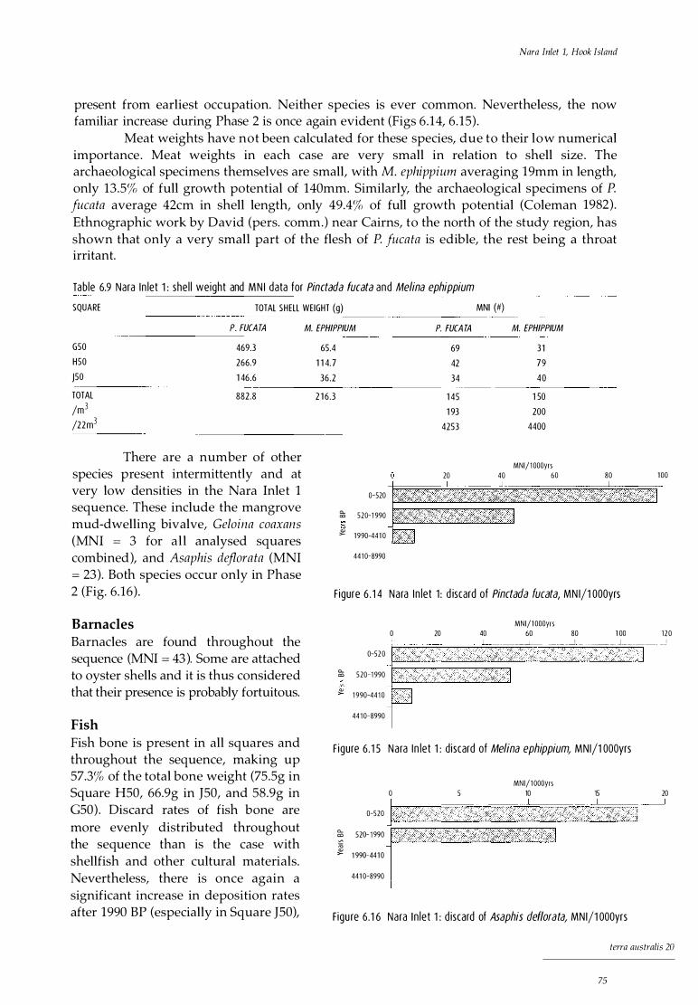
Nara Inlet 1, Hook Island
present from earliest occupation. Neither species is ever common. Nevertheless, the now familiar increase during Phase 2 is once again evident (Figs 6 .14, 6 . 15) .
Meat weights have not been calculated for these species, due to their low numerical importance . Meat weights in each case are very small in relation to shell size . The archaeological specimens themselves are small, with M. ephippium averaging 19mm in length, only 13.5% of full growth potential of 140mm. Similarly, the archaeological specimens of P fucata average 42cm in shell length, only 49.4% of full growth potential (Coleman 1982). Ethnographic work by David (pers. comm.) near Cairns, to the north of the study region, has shown that only a very small part of the flesh of P fucata is edible, the rest being a throat irritant.
Tab le 6.9 Nara I n let 1 : she l l weight and MN I data for Pinctada fucata and Melina ephippium
SQUARE TOTAL SHELL WEIGHT (g) MNI (#) P. FUCA TA M. EPHIPP/UM P. FUCA TA
G50 469.3 65.4 69 H50 266.9 1 1 4. 7 42 J50 1 46.6 36.2 34
TOTAL 882.8 2 1 6.3 1 45 /m3
1 93 /22m3
4253
20 40
0-520
Cl... 520-1 990 CJ
"" � 1 990-441 0
441 0-8990
M. EPHIPP/UM
31
79
40
1 50
200
4400
MNl/1 000yrs 60 80
There are a number of other species present intermittently and at very low densities in the Nara Inlet 1 sequence. These include the mangrove mud-dwelling bivalve, Geloina coaxans (MNI = 3 for al l analysed squares combined), and Asaphis deflorata (MNI = 23 ). Both species occur only in Phase 2 (Fig. 6.16) . F igure 6 . 1 4 Nara I n let 1 : d iscard of Pinctada fucata, MN l/1 OOOyrs
Barnacles MNl/1 000yrs
1 00
Barnacles are found throughout the sequence (MNI = 43 ). Some are attached to oyster shells and it is thus considered that their presence is probably fortuitous.
0 20 40 60 80 1 00 1 2 0
Fish Fish bone is present in all squares and throughout the sequence, making up 57.3% of the total bone weight (75.Sg in Square H50, 66.9g in J50, and 58.9g in G50) . Discard rates of fish bone are more evenly distributed throughout the sequence than is the case with shellfish and other cultural materials. Nevertheless, there is once again a significant increase in deposition rates after 1990 BP (especially in Square J50),
0-52 0
_J______ __ - -�---- -- L ______ __L__ _ __ _ _J ___ J _______ _ J
&; 5 20-1 990 i...-�-�------' "" <lJ
>- 1 990-441 0
441 0-8990
F igure 6 . 1 5 Nara I n let 1 : d iscard of Melina ephippium, MNl/1 OOOyrs
MNl/1 000yrs 0 5 10 15 20 r========�L==�====-�====�=- =-- J�==�- - ___J
0-520 i.-�-----"--------------...........0
� 1 :::�:�: 1 441 0-8990 l
F igu re 6.1 6 Nara I n let 1 : d iscard of Asaphis def/orata, MNl/1 OOOyrs
terra australis 20
75
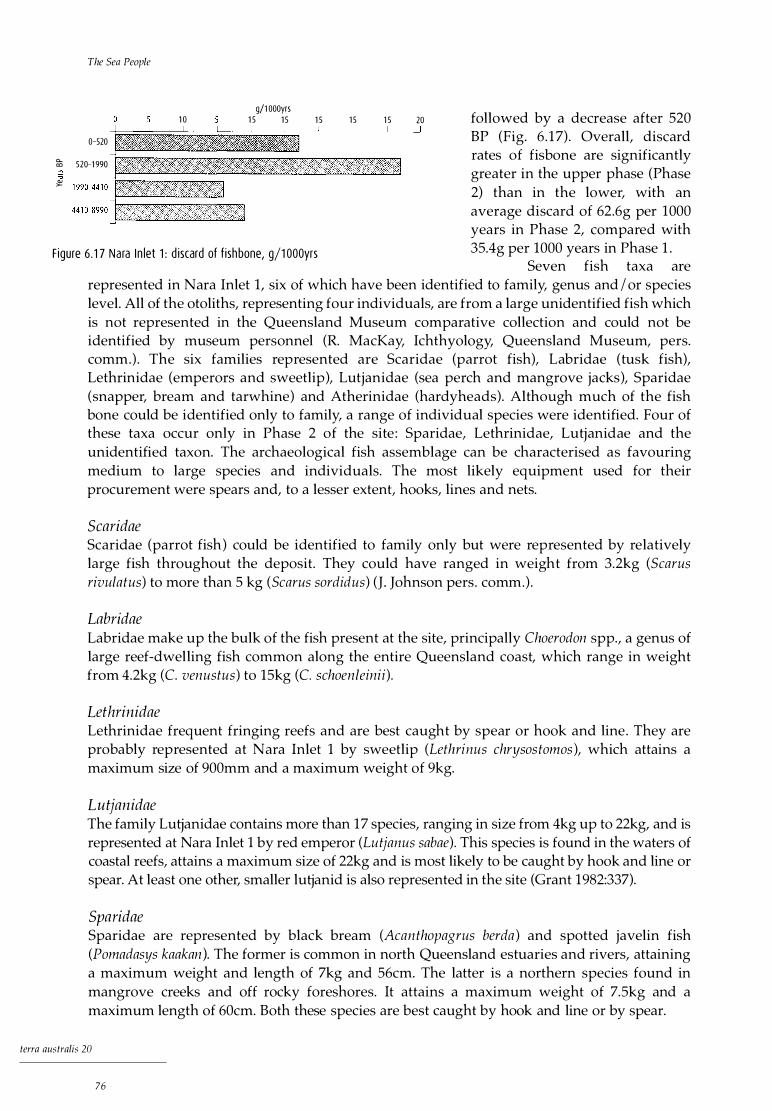
The Sea People
1 0
0-520
g/1 000yrs 1 5 1 5 1 5 1 5 1 5 20
:ii 520-1 990 r:;;:����������'."'7T�����""'."1
followed by a decrease after 520 BP (Fig. 6 . 1 7) . Overall, discard rates of fisbone are significantly greater in the upper phase (Phase 2) than in the lower, with an average discard of 62.6g per 1000 years in Phase 2, compared with 35.4g per 1000 years in Phase 1 .
"" �
F igure 6 . 1 7 Nara I n let 1 : d iscard of f ishbone, g/1 OOOyrs Seven fish taxa are
represented in Nara Inlet 1, six of which have been identified to family, genus and / or species level. All of the otoliths, representing four individuals, are from a large unidentified fish which is not represented in the Queensland Museum comparative collection and could not be identified by museum personnel (R. MacKay, Ichthyology, Queensland Museum, pers. comm.) . The six families represented are Scaridae (parrot fish), Labridae (tusk fish), Lethrinidae (emperors and sweetlip), Lutjanidae (sea perch and mangrove jacks), Sparidae (snapper, bream and tarwhine) and Atherinidae (hardyheads). Although much of the fish bone could be identified only to family, a range of individual species were identified. Four of these taxa occur only in Phase 2 of the site : Sparidae, Lethrinidae, Lutjanidae and the unidentified taxon. The archaeological fish assemblage can be characterised as favouring medium to large species and individuals. The most likely equipment used for their procurement were spears and, to a lesser extent, hooks, lines and nets.
Scaridae Scaridae (parrot fish) could be identified to family only but were represented by relatively large fish throughout the deposit. They could have ranged in weight from 3.2kg (Scarus rivulatus) to more than 5 kg (Scarus sordidus) (J. Johnson pers. comm.) .
Labridae Labridae make up the bulk of the fish present at the site, principally Choerodon spp., a genus of large reef-dwelling fish common along the entire Queensland coast, which range in weight from 4.2kg (C. venustus) to 15kg (C. schoenleinii) .
Lethrinidae Lethrinidae frequent fringing reefs and are best caught by spear or hook and line. They are probably represented at Nara Inlet 1 by sweetlip (Lethrinus chrysos tomos ), which attains a maximum size of 900mm and a maximum weight of 9kg.
Lutjanidae The family Lutjanidae contains more than 1 7 species, ranging in size from 4kg up to 22kg, and is represented at Nara Inlet 1 by red emperor (Lutjanus sabae). This species is found in the waters of coastal reefs, attains a maximum size of 22kg and is most likely to be caught by hook and line or spear. At least one other, smaller lutjanid is also represented in the site (Grant 1982:337).
Sparidae Sparidae are represented by black bream (Acan thopagrus berda ) and spotted javelin fish (Pomadasys kaakan ). The former is common in north Queensland estuaries and rivers, attaining a maximum weight and length of 7kg and 56cm. The latter is a northern species found in mangrove creeks and off rocky foreshores. It attains a maximum weight of 7.5kg and a maximum length of 60cm. Both these species are best caught by hook and line or by spear.
terra australis 20
76

Table 6 . 1 o Nara I n let 1 : strat igraph ic d istrib ut ion of f ish fam i l ies by MN I
SU
2
TOTALS
XU
5
8
1 4
1 5
1 7
1 8
23
24
27
29
30
3 1
32
33
34
35
36
41
42
43
44
45
Atherinidae
SCARIDAE
2
9
SPARIOAE LETHR IN IOAE LUTJANIOAE LABR IOAE ATH ER IN IOAE
2
2
2
2
4 2 1 9
Nara Inlet 1 , Hook Island
UN ID ENT.
4
TOTAL
2
3
5
2
2
2
1
2
40
The smallest fish species present in Nara Inlet 1 is hardyhead (Pranesus ogilbyi), a small shoaling fish found in bays, estuaries and inlets. This species attains a maximum length of 17cm and is most readily caught in nets.
Minimum numbers and meat weights An overall MNI of 40 fish has been calculated for Squares GSO, HSO and JSO at Nara Inlet (Table 6 . 10). This averages out to 53 .3 fish per m3 of deposit and amounts to 1173 fish for the entire site. If we allow the maximum gross weight for each taxon represented, the 40 identified individuals add up to a total of 409kg of fish and 272.7kg of meat, calculated as two-thirds of gross body weight. This is the equivalent of 363.6kg per cubic metre of deposit. A potential fish meat total for the entire deposit of 22m3 is 7999.2kg.
Crustaceans The major crab species identified in the Nara Inlet 1 site is the mud crab, Scylla serrata, which lives in mangrove swamps and thrives in a water temperature zone between 14° and 20°C. First-stage zoeae of S . serrata are not tolerant of water temperatures above 25°C and, although they can survive in water temperatures as low as 5°C, they are inactive below 10°c and this probably represents their lower viable limit. Furthermore, they are not tolerant of salinity levels below 17.Sp / million (Hill 1974). Mud crab is considered a tropical species and is not found today south of Moreton Bay in subtropical south-east Queensland. Its presence throughout the Nara Inlet 1 sequence establishes the presence of macrophytic communities in the region from before 9000 BP and a water temperature range commensurate with a tropical I subtropical climate .
Crabs are present throughout the sequence in all analysed squares (Table 6. 11 ), with a total shell weight of 113.6g. Species present besides S. serrata include Portun us pelagicus (sand
tcrra australis 20
77

The Sea People
crab), a swimming crab weighing up to lkg, and Thalamita s ima, a small (60mm) but ubiquitous species. All species are extant in the region today. Minimum numbers of individuals were not calculated for crustaceans. Species presence only was noted, using identifiable elements such as claws. Figure 6 . 18 shows a significant increase in crustacean shell discard rates during Phase 2.
Tab le 6 .1 1 Nara In let 1 : stratig raph ic d istr ibut ion of crab she l l by species
SU XU SCYLLA SERRA TA PORTUNUS PELAGICUS THALAMITA SIMA OTHER
3 x
4 x
5 x
6 x
8 x x x
9 x x
1 1 x
1 3 x
1 4 x x
1 5 x x
1 6 x x
1 7 x
1 9 x
21 x
22 x
23 x
24 x x x
25 x
27 x
29 x x
30 x
3 34 x
37 x
39 x
42 x
43 x
44 x x
Significantly, from the point of view of establishing the early Holocene presence of macrophytic communities in the region, the mangrove-dwelling mud crab, Scylla serrata, is present from the initial time of occupation at Nara Inlet 1 (>9000 BP). However, the sand crab, Portunus pelagicus, is not present in Phase 1 .
0-520
a... 520-1 990 co
ro Q)
>- 1 990-441 0
441 0-8990
1 0 2 0 g/1 000yrs
30 40
F igure 6 .1 8 Na ra In let 1 : d iscard of crab she l l , g/1 OOOyrs
terra australis 20
78
50 60 70

Nara Inlet 1, Hook Island
Marine turtle Turtle bone or shell was present in all three analysed squares: shell in XU2 of Square G50, XU20 of Square H50 and XU23 of Square J50 and bone in XU9 and XU23 of Square J50. Turtle thus occurred only in Phase 2. Species identification was possible on the shell, which comes from the hawksbill turtle, Eretmochelys imbricata, and on bone from the green turtle, Chelonia mydas . Most of the Whitsunday Islands are not geomorphologically suitable for turtle nesting, which may explain the lack of any evidence for turtle eggs in any of the sites.
Given the occurrence in the same square of bone (from Che Zonia) and shell (from Eretmochelys) and the amount of undisturbed stratified deposit separating these from the other three occurrences and these three occurrences from each other, it is thought that the five fragments identified in the three squares probably represent five different individuals, three of Eretmochelys (from shell) and two of Chelon ia (from bone) . Because of the potential for a relatively wide horizontal distribution within a site of bone and shell belonging to a single individual of these large species, the MNI of five from the three 50 x 50cm squares under analysis was taken by convention (see the section in Chapter 5 on Calculating MNI from bone) to be the MNI of lm2. Since the maximum depth of the excavated squares was llOcm, close to lm, MNI was, again by convention, reckoned to be five per cubic metre .
Green turtles can weigh up to 180kg but average about 90kg, while hawksbills average about 40kg. Meat weight for the former is approximately 60kg per individual (Hoser 1989:48), giving a potential meat return in the three squares of 120kg. By convention, as explained above, this is taken to be 120kg per cubic metre . On this basis, the entire deposit of 22m3 gives a total meat weight of 2640kg for green turtle . Taking two-thirds of the maximum weight of a hawksbill turtle as meat, the 53.4kg meat weight of this species in the analysed squares is taken by convention to be the mean weight per cubic metre. On this basis, the meat weight of hawks bill in the entire deposit is 1 17 4.8kg. The combined total for turtle meat at the site thus amounts to 3814.8kg.
Other marine fauna In XU30 of Square H50 (Phase 2), seven large, sharp, peg-like teeth were found, the largest just more than 2cm in length. They have been identified only as belonging to one of the smaller toothed whales (Odontoceti).
A small number of sea-urchin spines were found in Square J50 in XU18, 24 and 25 of SU2 (Phase 2). The species has not been determined.
Terrestrial fauna Bone from terrestrial fauna totals 148 .8g, or 42.2% of the total bone weight in the three analysed squares (G50, H50, J50), with an MNI of 48. There are five species of mammal, including the unadorned rock wallaby (Petrogale inornata), possum (Trichosurus vulpecula ), bandicoot (Perameles nasuta ) and two rodents, Melomys cervinipes and Rattus fuscipes coracius. Also present are three species of reptile: goanna (Varanidae), lizard (Agamidae) and python (Morelia sp. ) . Bird bone is also present but has not been further identified . The stratigraphic distribution of the terrestrial fauna at the site is set out in Table 6 .12 . As can be seen from Figure 6 .19, deposition rates of terrestrial bone do not change as drastically between Phases 1 and 2 as with other cultural material (see Figs 6.5 to 6 .18). Some of the species, in particular the rodents, small lizards (Agamidae) and even the bird remains, may not all be cultural.
terra australis 20
79

The Sea People
0-520
c... 520-1 990 cc
ro � 1 990-441 0
441 0-8990
1 0 g/1 000yrs
1 5 2 0 2 5
F igure 6 . 1 9 Nara I n let 1 : d i scard o f terrestr ia l bone, g/1 OOOyrs
Unadorned rock wallaby
30 35
The largest of the terrestrial species represented in the site is Petrogale inornata, a small solitary macropod which inhabits rainforest or wet sclerophyll forest. This animal attains a maximum body length of 500mm and averages 4.3kg for adult males (Strahan 1983:213) . A total MNI of 11 individuals gives a potential meat weight, calculated at 2.8kg / individual (which equals two-thirds of body weight), of 30.8kg over the three analysed squares. By the convention established for large animals in Chapter 5, in the section on Calculating MNI from bone, the 0.75m3 of deposit represented by the three squares becomes lm3 for purposes of extrapolation to the 22m3 of the whole site. On this basis there is a total potential meat return of 677.6kg for the site.
Possum Meat weight for possum is taken to be 3kg or two-thirds of maximum body weight of 4.5 kg. With an MNI of two, there is a meat weight of 6kg for the three analysed squares, conventionally reckoned as 6kg per m3. This translates to 132kg for the entire site .
Bandicoot Individual meat weight for bandicoot is estimated at 0 .73kg, or two-thirds of maximum body weight of 1 . lkg. With a minimum of three individuals in the analysed squares, there is a meat weight of 2 .2kg for the cubic metre conventionally represented there, which amounts to 48.2kg for the entire site.
Goanna and python Meat weights were not calculated for goanna and python because of the difficulty of obtaining weight data for these species . It is considered, however, that each species would probably average 2-4kg in total body weight and would therefore have provided reasonably significant meat weights per individual .
Birds and birds ' eggs Meat weights were not calculated for bird as it was not possible to further identify the fragments of bird bone. The highly fragmented nature of the bone did, however, suggest that birds were a resource, albeit (with a MNI of two) an extremely ephemeral one. A more consistent resource provided by birds were eggs, evident from the presence of eggshell, mostly in Square J50 (Table 6 . 12) . The tiny size of the fragments precluded species identification. The only reference to birds and their eggs in terms of resources in the Whitsundays is to the Torres Strait pigeon (Ducula spilorrhea), which migrates southward in the summer wet season, when birds and eggs were part of the diet (Lamond 1960:35; Roth 190l :v3:28). There are other edible birds and eggs, however, available in the islands.
tcrra australis 20
80

Nara Inlet 1, Hook Island
Tab le 6 .1 2 Na ra In let 1 : stratigraph ic d istrib ut ion of terrestria l fauna by MN I
SU XU PETROGALE TRICHOSURUS PE RAMALES MELOMYS RA TTUS VARAN IDAE AGAMIDAE MOREL/A B IRD B IRD TOTAL
INORNATA VULPECULA NASUTA CERVINIPES FUSCIPES EGGSH ELL
x 4
x 2
2
4 x 1
5 x
2 6 x
7 x
9 x
1 0 2
1 4
1 7 x
1 8 x
1 9 x 1
20 2
2 1 x
22
24 x
29 x
30
32
33 x
34 x
35 x 1
36 x 2
37 2 x 3
38
40
41
42 x
43
44
45 2 4
4 46
TOTALS 1 1 2 3 1 3 7 3 2 48
Plant material Surprisingly, there was a range of well-preserved remains of edible and other plants in the deposit. Four edible species were identified: Burdekin plum (Pleiogynium timorense), identified from seed; orange mangrove (Bruguiera gymnorhiza), identified from flowers; cocky apple (Planchon ia careya ), identified from seed; and cycad ( Cycas media), identified from husks, as well as wood from the grass tree (Xan thorrhoea) and sheets of paperbark from Melaleuca.
Table 6.13 shows the stratigraphic distribution in the site of the four edible species discussed above, but it is a preliminary listing only. Other plant materials, such as seeds, bark, leaves and wood, are under continuing analysis in the Department of Botany, University of Queensland.
Cycad nuts and mangrove pods require considerable processing before consumption. Bruguiera gymnorhiza contains a high proportion of tannin and must be extensively leached before eating (Cribb and Cribb 1987:94). Cycads contain highly toxic carcinogens and must also be leached (Cribb and Cribb 1987:97). Both of these species occur only after 520 BP at Nara Inlet 1, although once they appear they are fairly numerous. Overall, there were 80 seeds and shells of the four edible taxa.
terra australis 20
81
The Sea People
Table 6 . 1 3 Nara I n let 1 : strat igraph ic d istri but ion of ed ible p lants by MNI SU XU PLEIOGYN/UM PLANCHONIA CYCAS MEDIA BRUGUIERA TOTAL
TIMORENSE CAREYA GYMNORHIZA
1 1 4 6 2 3 1 4 3 2 3 4 4
5 2 2 4 1 0 6 2 2 6 7 2 3 8 3 3 9 2 2
1 0 3 1 1 9 1 0 1 2 3 3
1 3 3 3
1 4
1 5
1 6 4 4
1 7 1
1 8
1 9
20 1
2 1 2 2
25 1
26
28
3 1
3 32
36
TOTALS 56 1 0 7 7 80
Land snails Land snails in archaeological sites are an important source of palaeoenvironmental information as they are particularly sensitive to environmental change (David and Stanisic 1991; Shackley 1981 ) . The species found in Nara Inlet 1 is Ben tosites macleayi, a large surfacelitter dweller extant in the region today, whose usual habitat is tropical vine thicket with a preference for wet conditions. Recorded close to 9000 BP at an early stage of the occupation, B. macleayi was present in the early part of the sequence in XU44, 40 and 38 of Squares G50 and H50 and less frequently represented subsequently, in XU23 and 24 of Square J50.
It is unclear whether this species was a resource or occurred in the deposit naturally. However, its temporal distribution in the site indicates that wet tropical environments were in place by about 9000 BP in the Whitsunday region.
Lithic artefacts There was a total of 720 stone artefacts in the three analysed squares, an average of 960 per cubic metre of deposit. Of these, 615 (85.4% ) belonged to Phase 1 and 1 05 ( 14.6% ) to Phase 2. This indicates a greater average stone artefact discard rate in Phase 1 (87.9 artefacts per 1000 years) than in Phase 2 (52.8 per 1000 years) (Fig. 6.20).
Ninety-two per cent of the stone artefact assemblage was made from a homogeneous, fine-grained, black volcanic tuff like that found on South Molle Island, where exploitation was recorded historically (see Chapter 10 for full discussion). The remaining artefacts were made from a variety of highly siliceous rocks of volcanic origin.
tcrra australis 20
82

0-520
a.. 520-1990 cc
"' � 1 990-4410
441 0-8990
20 40 #/1 000yrs
60 80
F igure 6.20 Na ra I n let 1 : d iscard of stone a rtefacts, # /1 OOOyrs
Nara Inlet 1, Hook Island
1 00 1 20
The stone artefacts from Squares G50 and H50 were analysed, 46 of them belonging to Phase 2, 215 to Phase 1 . The assemblage consisted of flaked pieces (8% ), flakes (34% ) and broken flakes (56% ). Only 1 .6% of flakes or broken flakes had evidence of retouch. There were no cores. The stone artefacts had an average weight overall of 0.58g, 0.55g in Phase 1 and 0.61g in Phase 2. A large percentage showed tertiary stages of decortication (83.5% ), with 13.4% secondary and 3% primary decortication. Platform preparation in the form of overhang removal or platform facetting was present on 96.9% of all flakes in Phase 1 and 13.3% in Phase 2. Termination types were dominated by feather (58 .7% ), hinge (24.7% ) and step (16.5% ) terminations.
N on-lithic artefacts The unexpected decrease in discard rates of stone artefacts in Phase 2 coincides with the appearance of a number of non-lithic artefacts. Indeed, these are restricted to Phase 2, where they make up 10% of the artefact assemblage. While the younger age of Phase 2 might be favourable to the preservation of organic remains such as wood and string, it would not be a factor in the case of bone and shell.
The non-lithic artefacts consist of two rectangular pieces of cut and ground turtle shell, a wooden bipoint, three shell scrapers, a shell with a rectangular piece cut from it, a shell disc thought to be a fish-hook blank, four points (three made from bone and one from turtle shell) and pieces of netting made from grass fibre.
Worked turtle shell The turtle shell pieces (from Eretmochelys imbricata) measure 31 .2 x 25.lmm and 15.9 x 17.7mm. Both have long and deep cut marks on both sides (Plate 6 .3 ) . These artefacts are clearly the byproduct of the manufacture of some other tool, perhaps fish-hooks or points. A turtle-shell point was found in XU23 in Square J50. No fish-hooks were excavated at the site, but historical records frequently mention them being made from turtle shell in the Whitsunday region.
Table 6 . 1 4 Na ra In l et 1 : stra t igraph ic d istr ibut ion of non- l i th ic a rtefacts
SU
XU 2 1 6 1 7 1 9
Cut turtle shel l x
Turtle shel l point
Bone point x
Wooden point x
Shel l scraper x
Other shel l a rtefacts x Netting x
TOTALS 2
2
20 22 23
x
x
x
x
x
2 2
27 29
x
x
TOTAL
3
2
1 3
terra australis 20
83
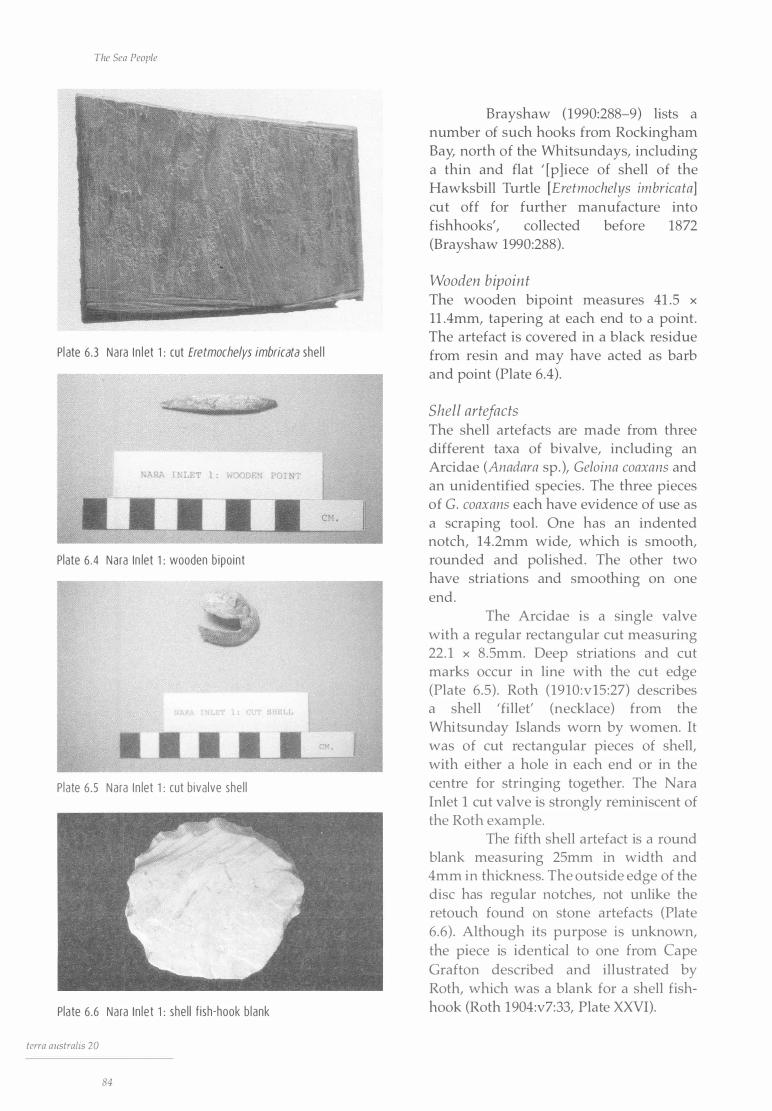
The Sea People
Pl ate 6 .3 Nara I n l et 1 : cut Eretmoche/ys imbricata shel l
RA I .LET l : WOODEN POI T
Plate 6 .4 Nara In let 1 : wooden b ipo int
H L
Plate 6 .5 Nara I n let 1 : cut b iva lve she l l
Pla te 6 .6 Nara In le t 1 : she l l f ish-hook b lank
terra australis 20
84
Brayshaw (1990:288-9) lists a number of such hooks from Rockingham Bay, north of the Whitsundays, including a thin and flat ' [p]iece of shell of the Hawksbill Turtle [Eretmochelys imbrica ta] cut off for further manufacture into fishhooks', collected before 1872 (Brayshaw 1990:288 ).
Wooden bipoint The wooden bipoint measures 41 .5 x
11 .4mm, tapering at each end to a point. The artefact is covered in a black residue from resin and may have acted as barb and point (Plate 6.4).
Shell artefacts The shell artefacts are made from three different taxa of bivalve, including an Arcidae (Anadara sp. ), Geloina coaxans and an unidentified species . The three pieces of G. coaxans each have evidence of use as a scraping tool. One has an indented notch, l 4.2mm wide, which is smooth, rounded and polished . The other two have striations and smoothing on one end.
The Arcidae is a single valve with a regular rectangular cut measuring 22. 1 x 8.5mm. Deep striations and cut marks occur in line with the cut edge (Plate 6.5) . Roth (1910 :vl5 :27) describes a shell 'fillet' (necklace) from the Whitsunday Islands worn by women. It was of cut rectangular pieces of shell, with either a hole in each end or in the centre for stringing together. The Nara Inlet 1 cut valve is strongly reminiscent of the Roth example.
The fifth shell artefact is a round blank measuring 25mm in width and 4mm in thickness. The outside edge of the disc has regular notches, not unlike the retouch found on stone artefacts (Plate 6.6) . Although its purpose is unknown, the piece is identical to one from Cape Grafton described and illustrated by Roth, which was a blank for a shell fishhook (Roth 1904:v7:33, Plate X:XVI).
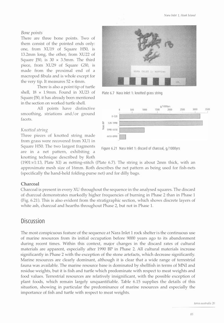
Nara Inlet 1, Hook Island
Bone points There are three bone points . Two of them consist of the pointed ends only: one, from XU19 of Square H50, is 13.2mm long, the other, from XU22 of Square J50, is 30 x 3.Smm. The third piece, from XU29 of Square G50, is made from the proximal end of a macropod fibula and is whole except for the very tip. It measures 52 x 4mm.
There is also a point tip of turtle shell, 18 x l .9mm. Found in XU23 of Square J50, it has already been mentioned in the section on worked turtle shell.
All points have distinctive smoothing, striations and I or ground facets.
Knotted s tring Three pieces of knotted string made from grass were recovered from XUl in
Plate 6. 7 Nara I n let 1 : knotted g rass string
0-520
441 0-8990 �D
500 J_
1000 l
g/1 000yrs 1 500 2000
l J_
Square H50. The two largest fragments F igu re 6 .2 1 Nara I n let 1 : di sca rd of charcoal, g/1 000yrs are in a net pattern, exhibiting a knotting technique described by Roth
2500 J_
3000 J_
(190l :vl : l3, Plate XI) as netting-stitch (Plate 6 .7). The string is about 2mm thick, with an approximate mesh size of 16mm. Roth describes the net pattern as being used for fish-nets (specifically the hand-held folding-purse net) and for dilly bags.
Charcoal Charcoal is present in every XU throughout the sequence in the analysed squares. The discard of charcoal demonstrates markedly higher frequencies of burning in Phase 2 than in Phase 1 (Fig. 6.21 ). This is also evident from the stratigraphic section, which shows discrete layers of white ash, charcoal and hearths throughout Phase 2, but not in Phase 1 .
D iscuss ion
The most conspicuous feature of the sequence a t Nara Inlet 1 rock shelter i s the continuous use of marine resources from its initial occupation before 9000 years ago to its abandonment during recent times. Within this context, major changes in the discard rates of cultural materials are apparent, especially after 1990 BP in Phase 2. All cultural materials increase significantly in Phase 2 with the exception of the stone artefacts, which decrease significantly. Marine resources are clearly dominant, although it is clear that a wide range of terrestrial fauna was available. The marine resource base is dominated by shellfish in terms of MNI and residue weights, but it is fish and turtle which predominate with respect to meat weights and food values. Terrestrial resources are relatively insignificant, with the possible exception of plant foods, which remain largely unquantifiable. Table 6 . 15 supplies the details of this situation, showing in particular the predominance of marine resources and especially the importance of fish and turtle with respect to meat weights.
J 3500
J
terra australis 20
85

The Sea People
Table 6 .15 does not include the contribution of a range of sporadically occurring fauna and flora. These include crustaceans, whale, some minor shellfish species, birds' eggs, snakes, lizards and, perhaps most importantly, plant foods. In the notable case of whale, a single individual may have offered high food yields for a short period in an unscheduled way, in the sense that there is no evidence to suggest whales represented a targeted, repeated or predictable part of the economy.
Shellfish Of the shellfish species, rock-platform gastropods and chitons predominate, with Nerita undata and Monodonta labia making up the bulk of the shell species at all times. The most common bivalves throughout the deposits are Saccostrea cuculla ta and Trichomya h irsu ta, both of which live on rock platforms. Bivalve species such as Pinctada fucata, Melina eph ippium, Geloina coaxans and Asaphis deflorata are all mud or sand dwellers and present only in small quantities . Asaphis deflorata, Geloina coaxans and Pinctada fucata are present only in Phase 2.
The predominance of rock-platform species over mud or sand varieties during the entire sequence is without doubt a reflection of local geomorphology at Nara Inlet: there is little or no beach fringe and small, sparse areas of relatively newly established macrophytic communities. It is possible that the absence of some of the mud species in Phase 1 could also point to a less developed state of the mangrove systems before sea-level stabilisation ea. 7000 years ago. It is important to note, however, that macrophytic communities were present throughout the period of occupation of Nara Inlet 1, although not necessarily in Nara Inlet itself, as evidenced by the presence of the mangrove-dependent mud crab, Scylla serrata, and the mud-dwelling bivalve shellfish, Melina ephippium, from the lowest levels of occupation.
The relative numerical importance of the various shell species at Nara Inlet 1 is similar to that observed in the inlet today. Meat weights for shellfish are low, making up only 6.6% of the meat estimate for the three analysed squares (from the data in column 1 of Table 6 .15), with chiton forming 68. 1 % of the total weight of the shellfish meat. This may indicate a relatively casual approach to shellfish gathering and an absence of targeting of a dominant, perhaps distant shellfish species. This is consistent with the findings that shellfish are not the principal contributor to overall diets (Meehan 1977, 1 982) . All the shellfish species show a marked and significant increase in discard during Phase 2, with chiton and oyster showing the least variation, although still a significant change, between the two phases. Coinciding with this increase in shell discard is a corresponding decrease in the size of the most prolific species exploited, Nerita undata, in Phase 2 (see Fig. 6 .7).
Fish Fish are the most significant resource at Nara Inlet 1, making up 52.5% of the total calculated meat returns (Table 6.15, column 1 ) . Labridae are the most numerous (47.5% of MNI in Table 6.10) and among them Choerodon spp. is the most conspicuous. Lethrinidae, probably represented by Lethrinus chrysostomus, account for 10% of MNI (Table 6.10). These are large species with the potential to provide high meat returns. Fish become a more important component of the resource base in Phase 2 with the introduction of four new species, including the very large Lutjanus sabae. Nevertheless, there is every reason to assume that, in terms of MNI, fish are significantly underrepresented in archaeological sites (see the section on MNI for fish in Chapter 5).
The species present tend to show that a wide variety of fishing technologies were utilised, including spears, nets, traps and hook and line. As with the shellfish, all the fish taxa occur in the region today and most are northern tropical reef-dwelling varieties requiring a relatively high water temperature. This indicates relative environmental stability throughout the 9000 and more years of the site's occupation.
terra australis 20
86
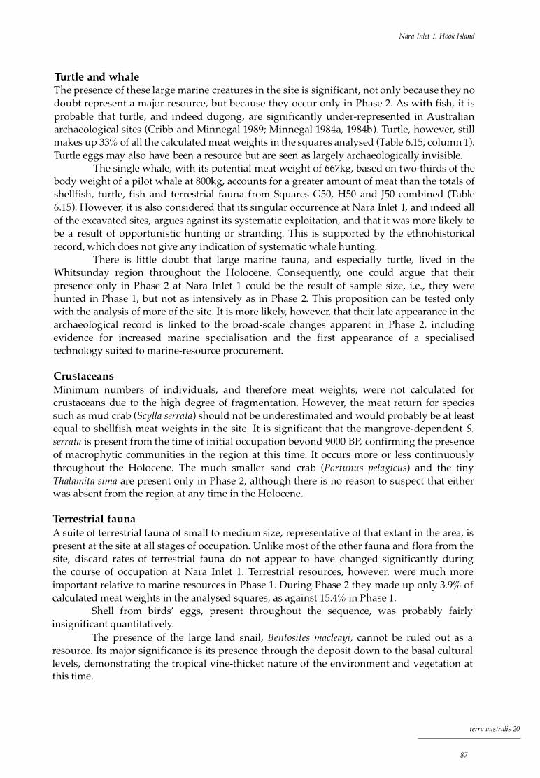
Nara Inlet 1, Hook Island
Turtle and whale The presence of these large marine creatures in the site is significant, not only because they no doubt represent a major resource, but because they occur only in Phase 2. As with fish, it is probable that turtle, and indeed dugong, are significantly under-represented in Australian archaeological sites (Cribb and Minnegal 1989; Minnegal l 984a, 1984b ). Turtle, however, still makes up 33% of all the calculated meat weights in the squares analysed (Table 6 .15, column 1 ). Turtle eggs may also have been a resource but are seen as largely archaeologically invisible.
The single whale, with its potential meat weight of 667kg, based on two-thirds of the body weight of a pilot whale at 800kg, accounts for a greater amount of meat than the totals of shellfish, turtle, fish and terrestrial fauna from Squares G50, H50 and J50 combined (Table 6 .15). However, it is also considered that its singular occurrence at Nara Inlet 1, and indeed all of the excavated sites, argues against its systematic exploitation, and that it was more likely to be a result of opportunistic hunting or stranding. This is supported by the ethnohistorical record, which does not give any indication of systematic whale hunting.
There is little doubt that large marine fauna, and especially turtle, lived in the Whitsunday region throughout the Holocene . Consequently, one could argue that their presence only in Phase 2 at Nara Inlet 1 could be the result of sample size, i .e ., they were hunted in Phase 1, but not as intensively as in Phase 2. This proposition can be tested only with the analysis of more of the site. It is more likely, however, that their late appearance in the archaeological record is linked to the broad-scale changes apparent in Phase 2, including evidence for increased marine specialisation and the first appearance of a specialised technology suited to marine-resource procurement.
Crustaceans Minimum numbers of individuals, and therefore meat weights, were not calculated for crustaceans due to the high degree of fragmentation. However, the meat return for species such as mud crab (Scylla serra ta) should not be underestimated and would probably be at least equal to shellfish meat weights in the site . It is significant that the mangrove-dependent S. serra ta is present from the time of initial occupation beyond 9000 BP, confirming the presence of macrophytic communities in the region at this time. It occurs more or less continuously throughout the Holocene. The much smaller sand crab (Portunus pelagicus) and the tiny Thalamita sima are present only in Phase 2, although there is no reason to suspect that either was absent from the region at any time in the Holocene.
Terrestrial fauna A suite of terrestrial fauna of small to medium size, representative of that extant in the area, is present at the site at all stages of occupation. Unlike most of the other fauna and flora from the site, discard rates of terrestrial fauna do not appear to have changed significantly during the course of occupation at Nara Inlet 1 . Terrestrial resources, however, were much more important relative to marine resources in Phase 1 . During Phase 2 they made up only 3.9% of calculated meat weights in the analysed squares, as against 15.4% in Phase 1 .
Shell from birds' eggs, present throughout the sequence, was probably fairly insignificant quantitatively.
The presence of the large land snail, Ben tosi tes macleayi, cannot be ruled out as a resource . Its major significance is its presence through the deposit down to the basal cultural levels, demonstrating the tropical vine-thicket nature of the environment and vegetation at this time.
terra australis 20
87
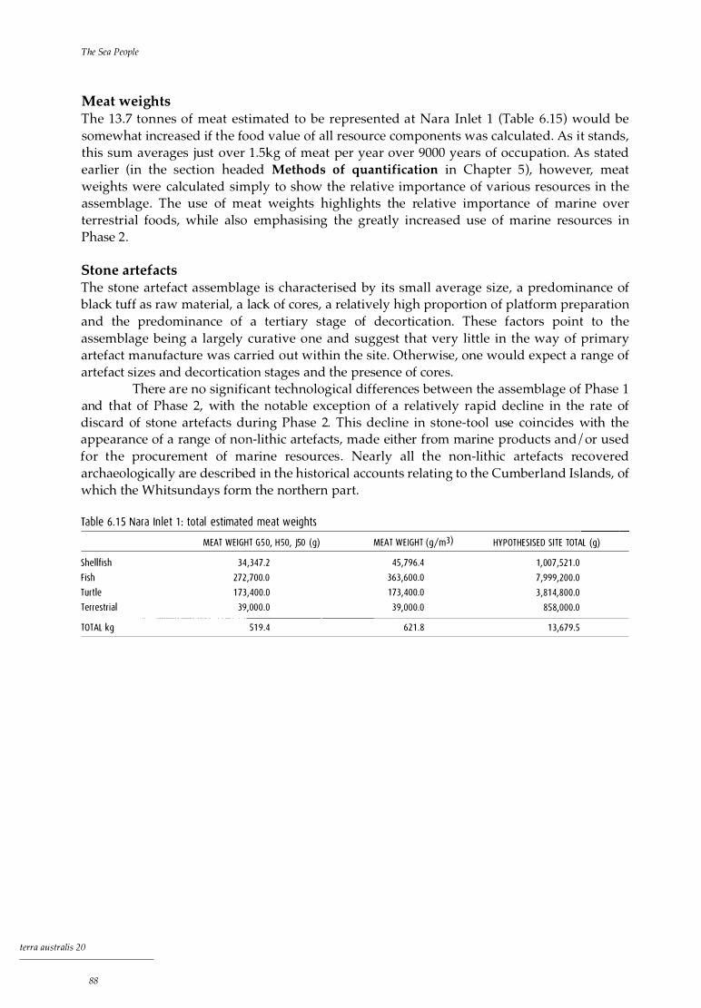
The Sea People
Meat weights The 13 .7 tonnes of meat estimated to be represented at Nara Inlet 1 (Table 6 .15) would be somewhat increased if the food value of all resource components was calculated. As it stands, this sum averages just over 1 .5kg of meat per year over 9000 years of occupation. As stated earlier (in the section headed Methods of quantification in Chapter 5), however, meat weights were calculated simply to show the relative importance of various resources in the assemblage. The use of meat weights highlights the relative importance of marine over terrestrial foods, while also emphasising the greatly increased use of marine resources in Phase 2 .
Stone artefacts The stone artefact assemblage is characterised by its small average size, a predominance of black tuff as raw material, a lack of cores, a relatively high proportion of platform preparation and the predominance of a tertiary stage of decortication. These factors point to the assemblage being a largely curative one and suggest that very little in the way of primary artefact manufacture was carried out within the site. Otherwise, one would expect a range of artefact sizes and decortication stages and the presence of cores.
There are no significant technological differences between the assemblage of Phase 1 and that of Phase 2, with the notable exception of a relatively rapid decline in the rate of discard of stone artefacts during Phase 2. This decline in stone-tool use coincides with the appearance of a range of non-lithic artefacts, made either from marine products and I or used for the procurement of marine resources . Nearly all the non-lithic artefacts recovered archaeologically are described in the historical accounts relating to the Cumberland Islands, of which the Whitsundays form the northern part.
Tab le 6 . 1 5 Nara In let 1 : total estimated meat weights
MEAT WEIGHT G50, H50, J50 (g)
Shel l f ish 34,347.2
Fish 272,700.0
Turtle 1 73,400.0
Terrestr ia l 39,000.0
TOTAL kg 51 9.4
terra australis 20
88
MEAT WEIGHT (g/m3)
45,796.4
363,600.0
1 73,400.0
39,000.0
621 .8
HYPOTHESISED SITE TOTAL (g)
1 ,007,52 1 .0
7,999,200.0
3,81 4,800.0
858,000.0
1 3,679.5

Nara Inlet 1, Hook Island
Con c l us ion
In summary, the archaeological data from Nara Inlet 1 show that marine resources were exploited throughout the Holocene. There is no evidence of changes in the resource base or the density of discard of cultural material from 9000 BP until the stratigraphic break between SU3 and SU2, when clear and significant differences appear, marking the end of Phase 1 and the start of Phase 2. As discussed in the section on Cultural phases above, the stratigraphic break occurs between a date of 4410 BP below and one of 1190 BP above and on the assumption of a constant rate of sedimentation over the 14cm separating them would have taken place at 3027 BP. In the event a case was argued to use the actual date of 1990 BP rather than this estimated one for the transition between Phases 1 and 2 and the calculation of discard rates of cultural materials during each.
Phase 2 at the site saw a greatly increased discard of most cultural materials and the utilisation of an increased range of resources demonstrating a greater degree of marine specialisation, together with a shift in technological emphasis. This shift in technology seems to be closely linked to the greater emphasis on marine resource procurement, with a decline in the use of stone artefacts and a great reliance on a non-lithic tool kit more suited to marine hunting. A further significant increase in the discard rates of cultural materials is evident after ea . 520 BP, as well as the utilisation of toxic plants for food, specifically Cycas media and Bruguiera gymnorhiza .
As we shall see, the other excavated sites give concordant results in the matter of the changes represented by Phase 2 at Nara Inlet 1 and supply dates suggesting that 3000 BP is a reasonable beginning for them.
terra australis 20
89


Nara Inlet Art Site, Hook Island
Reg iona l Descr i p t ion
Situated some 400m across the inlet from Nara Inlet 1, Nara Inlet Art Site i s a large sandstone rock shelter on the eastern side of Nara Inlet, ea. 40m above high-water mark (see Plate 6 .1 ) . With a westerly outlook, the shelter measures llm across its entrance and extends 6m from the dripline to the back wall. The site has been developed as a heritage destination for tourists because of the presence of more than 60 non-figurative art motifs, discussed below. A boardwalk was placed over the archaeological deposit by the QNPWS in 1 983, designed so that it rested on top of the shelter floor and no part of it extended into the cultural deposit . It was constructed in sections to allow easy dismantling in anticipation of future archaeological excavations.
Na ra I n l et Art S i te
The Nara Inlet Art Site has a floor area of 40m2 and some 14m3 of cultural deposit with a maximum depth of 84cm. Stone artefacts, a large slab of yellow ochre, shells, various plant remains, goat faeces and debris from recent visitation, such as cigarette butts, were present on the surface before excavation. A total of 2 .5m2 was excavated in 10 50 x 50cm squares, G3-6, H3, H6, K2, KS, N3 and N6 (Fig. 7 .1 , Plate 7. 1 ) . European artefactual material in the upper units of Square N6 gave evidence of post-contact Aboriginal site use.
Two squares have been analysed, G3 and N6. Only the results from Square G3, the deepest of all the excavated squares, are presented here, representing 0.25m3 of deposit. Those from Square N6, which was similar in content and density to G3, will appear elsewhere (Brian in prep. ) .
terra australis 20
91

The Sea People
N6
6 3
D - - - - - - -
� �
_ - -
_ -
- - - - - - - - - - - - - - -Dii�P�IN E "- ,� ---- - - - - -- - -
- - - - - - - _ _ - - - _ - - - _ - - -
1 M
F igure 7 . 1 Nara I n let Art S ite: s ite map
P late 7 . 1 Na ra I n let Art S i te : v iew of excavat ion (1 m x SOcm)
terra australis 20
92
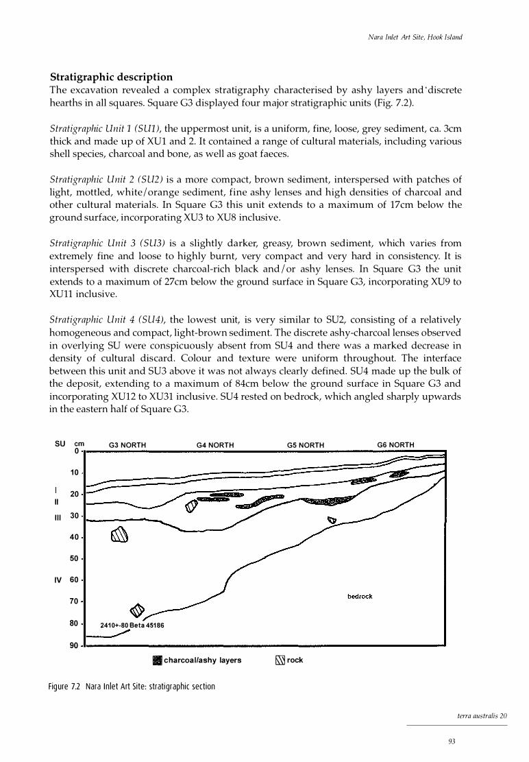
Nara Inlet Art Site, Hook Island
Stratigraphic description The excavation revealed a complex stratigraphy characterised by ashy layers and · discrete hearths in all squares. Square G3 displayed four major stratigraphic units (Fig. 7.2).
Stratigraphic Unit 1 (S Ul), the uppermost unit, is a uniform, fine, loose, grey sediment, ea. 3cm thick and made up of XUl and 2. It contained a range of cultural materials, including various shell species, charcoal and bone, as well as goat faeces.
Stratigraphic Unit 2 (S U2) is a more compact, brown sediment, interspersed with patches of light, mottled, white I orange sediment, fine ashy lenses and high densities of charcoal and other cultural materials. In Square G3 this unit extends to a maximum of 17cm below the ground surface, incorporating XU3 to XU8 inclusive .
Stratigraphic Unit 3 (SU3) is a slightly darker, greasy, brown sediment, which varies from extremely fine and loose to highly burnt, very compact and very hard in consistency. It is interspersed with discrete charcoal-rich black and / or ashy lenses. In Square G3 the unit extends to a maximum of 27 cm below the ground surface in Square G3, incorporating XU9 to XUll inclusive.
Stratigraphic Unit 4 (SU4), the lowest unit, is very similar to SU2, consisting of a relatively homogeneous and compact, light-brown sediment. The discrete ashy-charcoal lenses observed in overlying SU were conspicuously absent from SU4 and there was a marked decrease in density of cultural discard. Colour and texture were uniform throughout. The interface between this unit and SU3 above it was not always clearly defined. SU4 made up the bulk of the deposit, extending to a maximum of 84cm below the ground surface in Square G3 and incorporating XU12 to XU31 inclusive. SU4 rested on bedrock, which angled sharply upwards in the eastern half of Square G3.
SU cm G3 NORTH 0 G4 NORTH GS NORTH G6 NORTH
1 0
20 II
I l l 30
40
50
IV 60
70
80 241 0+-80 Beta 451 86
90 II charcoal/ashy layers &\'i rock
Fig ure 7.2 Nara I n let Art Site: strati graphic section
terra australis 20
93

The Sea People
Chronology
A single radiocarbon date is available for the site . It was obtained from charcoal from XU31, the basal excavation unit of G3, spanning a depth from 79. lcm to 83 . lcm below the ground surface in Square G3. It gave a date of 2410±80 BP (Beta 45186), which calibrates to 2720 (2350) 2150 (Table 7. 1 ), the value used in subsequent discussion.
Tab le 7.1 Na ra I n l et Art Site: rad iocarbon date
LAB NO SU XU DEPTH (cm) 1 4( bp AGE RANGE ca l BP .. ''
Beta 45 1 86 4 3 1 79. 1-83 . 1 241 0±80 2720 (2350) 21 50
... Stuiver and Reimer 1 993
As the entire sequence at the Nara Inlet Art Site is contemporaneous with the upper unit (Phase 2) of Nara Inlet 1, it is possible that the major stratigraphic change at the base of XU11, the interface between SU4 and SU3, may coincide with the change dated to 520 BP at Nara Inlet 1 . The latter change saw the onset of greatly increased rates of discard of cultural materials, as well as other, qualitative changes. Because a date for the XU11 stra tigraphic change at Nara Inlet Art Site has not been obtained, it appears that rates of discard of cultural material were greater in the early part of the site's occupation (SU4). This trend would be reversed if the stratigraphic change at XU11 did indeed date to about 520 BP.
Ana lys is of Cu l t u ra l Mater i a l
A s at all the other sites, marine resources at Nara Inlet Art Site predominate throughout the sequence, with 67% of all species present in Square G3 being of marine origin. The bulk of the cultural material is shellfish (81 .9% by weight), with a total weight in Square G3 of 14,485 . lg. The quantification of cultural material was carried out principally by calculating discard by volume of excavated material in each XU. As there is only a basal date from this site, discard over time (number I weight per 1000 years) is calculated only in order that comparisons in terms of densities of discard with other sites can be made. Nevertheless, the limitations of such an endeavour are fully recognised and therefore the results must be treated with caution.
Most of the faunal taxa present in the Nara Inlet Art Site were also found at nearby Nara Inlet 1 . The shellfish taxa recovered from the art site are all present at Nara Inlet 1, with the addition of two gastropods, Nerita lineata and N. polita, and a crab species, Myomenippe fornisin ii. The diversity of fish and terrestrial mammal species is not as broad at the art site, with only one identifiable fish taxon (Labridae), a single macropod species (Petrogale inornata) and a single rodent (Melomys cervinipes ) . Snake, goanna and other small reptiles are present, as well as land snails, birds and birds' eggs. There is no evidence of marine mammal, but marine turtle is well represented .
Shellfish In terms of numbers and weights, rock-dwelling gastropods predominate, with Nerita undata and Monodon ta labia the most common, followed by the turban shell, Lunella cinerea, and the chiton, Acan thopleura gemmata. The oyster, Saccos trea cuculla ta, is the dominant bivalve species, followed by the hairy mussel, Trichomya hirsu ta . Mud-dwelling bivalves such as Gelon ia coaxans, Pinctada fucata and Melina ephippium are present throughout the sequence in relatively low densities.
terra australis 20
94
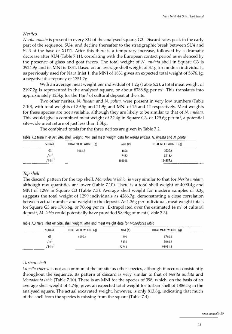
Nara Inlet Art Site, Hook Island
Nerites Nerita undata is present in every XU of the analysed square, G3. Discard rates peak in the early part of the sequence, SU4, and decline thereafter to the stratigraphic break between SU4 and SU3 at the base of XUll . After this there is a temporary increase, followed by a dramatic decrease after XU4 (Table 7. 11 ), correlating with the European contact period as evidenced by the presence of glass and goat faeces. The total weight of N. undata shell in Square G3 is 3924.9g and its MNI is 1831 . Based on an average shell weight of 3 . lg for modern individuals, as previously used for Nara Inlet 1, the MNI of 1831 gives an expected total weight of 5676.lg, a negative discrepancy of 1751 .2g.
With an average meat weight per individual of 1 .2g (Table 5.2), a total meat weight of 2197.2g is represented in the analysed square, or about 8788 .8g per m3. This translates into approximately 123kg for the 14m3 of cultural deposit at the site.
Two other nerites, N. lineata and N. palita, were present in very low numbers (Table 7.10), with total weights of 39.5g and 21 .9g and MNI of 1 5 and 12 respectively. Meat weights for these species are not available, although they are likely to be similar to that of N. u ndata. This would give a combined meat weight of 32.4g in Square G3, or 1 29 .6g per m3, a potential site-wide meat return of just less than l .8kg.
The combined totals for the three nerites are given in Table 7.2.
Ta b le 7.2 Nara In let Art S i te : shel l weight, MNI and meat weight data for Nerita undata, N. lineata and N. polita
Top shell
SQUARE TOTAL SHELL WEIGHT (g) MNI (#) TOTAL MEAT WEIGHT (g)
G3 /m3
/ 1 4m3
3986.3 1 858
7432
1 04048
2229.6
891 8.4
1 24857.6
The discard pattern for the top shell, Manadanta labia, is very similar to that for Nerita undata, although raw quantities are lower (Table 7 .10). There is a total shell weight of 4090.4g and MNI of 1299 in Square G3 (Table 7.3). Average shell weight for modern samples of 3.3g suggests the total weight of 1299 individuals as 4286 .7g, demonstrating a close correlation between actual number and weight in the deposit. At 1 .36g per individual, meat weight totals for Square G3 are 1 766.6g, or 7066g per m3 . Extrapolated over the estimated 14 m3 of cultural deposit, M. labia could potentially have provided 98.9kg of meat (Table 7.3).
Tab le 7 .3 Nara In let Art S i te: she l l weight, MN I and meat weight data for Monodonta labia ����- �����·
SQUARE TOTAL SHELL WEIGHT (g) MNI (#) TOTAL MEAT WEIGHT (g)
G3 /m3
/1 4m3
Turban shell
4090.4 1 299
5 1 96
72744
1 766.6
7066.6
98931 .8
Lunella cinerea is not as common at the art site as other species, although it occurs consistently throughout the sequence. Its pattern of discard is very similar to that of Nerita undata and Manadan ta labia (Table 7.1 0). There is an MNI for the species of 398, which, on the basis of an average shell weight of 4.7 4g, gives an expected total weight for turban shell of 1886.5g in the analysed square . The actual excavated weight, however, is only 813.8g, indicating that much of the shell from the species is missing from the square (Table 7.4).
terra australis 20
95
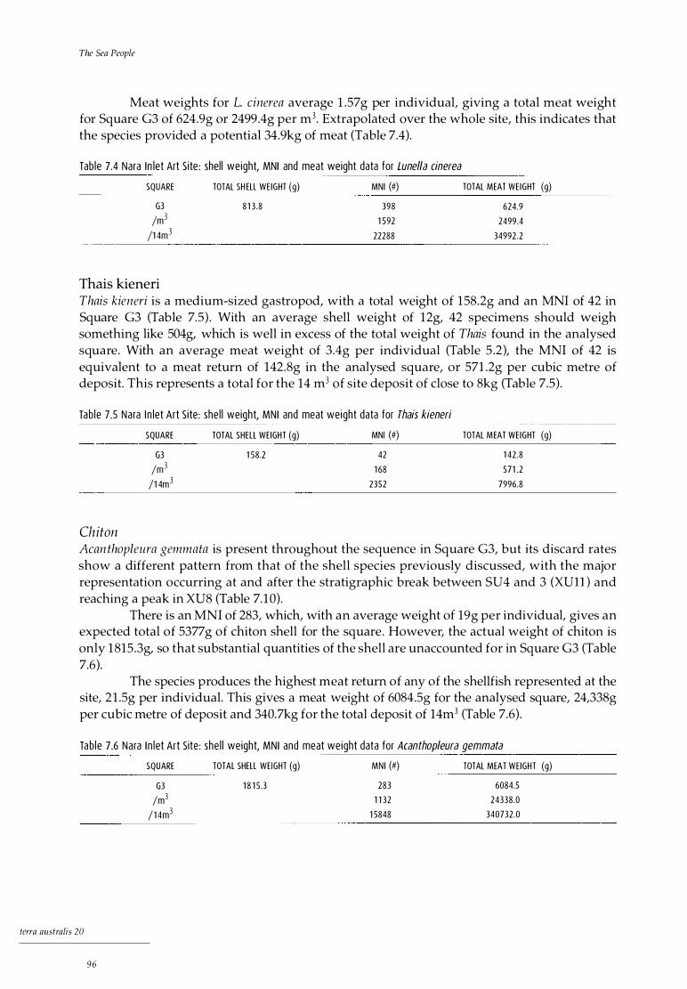
The Sea People
Meat weights for L. cinerea average 1 .57 g per individual, giving a total meat weight for Square G3 of 624.9g or 2499.4g per m3. Extrapolated over the whole site, this indicates that the species provided a potential 34.9kg of meat (Table 7.4).
Tab le 7.4 Nara In let Art S i te : shel l weight, MNI and meat weight data for Lune/la cinerea
SQUARE TOTAL SH ELL WE IGHT (g) MNI (#) TOTAL MEAT WEIGHT (g)
G3
/m3
/1 4m3
81 3 .8 398
1 592
22288
624.9
2499.4
34992.2
Thais kieneri Thais kieneri is a medium-sized gastropod, with a total weight of 158.2g and an MNI of 42 in Square G3 (Table 7.5) . With an average shell weight of 12g, 42 specimens should weigh something like 504g, which is well in excess of the total weight of Thais found in the analysed square. With an average meat weight of 3.4g per individual (Table 5 .2), the MNI of 42 is equivalent to a meat return of 142.8g in the analysed square, or 571 .2g per cubic metre of deposit. This represents a total for the 14 m3 of site deposit of close to 8kg (Table 7.5).
Tab le 7.5 Nara I n let Art S i te: she l l weight, MNI and meat weight data for Thais kieneri
Chi ton
SQUARE TOTAL SHELL WEIGHT (g) MNI (#) TOTAL MEAT WEIGHT (g)
G3
/m3
/1 4m3
1 58.2 42
1 68
2352
1 42 .8
571 .2
7996.8
Acan thopleura gemmata is present throughout the sequence in Square G3, but its discard rates show a different pattern from that of the shell species previously discussed, with the major representation occurring at and after the stratigraphic break between SU4 and 3 (XUll ) and reaching a peak in XU8 (Table 7. 1 0).
There is an MNI of 283, which, with an average weight of 19g per individual, gives an expected total of 5377g of chiton shell for the square . However, the actual weight of chiton is only 1 815 .3g, so that substantial quantities of the shell are unaccounted for in Square G3 (Table 7.6).
The species produces the highest meat return of any of the shellfish represented at the site, 21 .5g per individual. This gives a meat weight of 6084.Sg for the analysed square, 24,338g per cubic metre of deposit and 340.7kg for the total deposit of 14m3 (Table 7.6).
Ta b le 7.6 Nara I n let Art Site: she l l weight, MNI and meat weight data for Acanthopleura gemmata
tcrra australis 20
96
SQUARE TOTAL SHELL WEIGHT (g) MNI (#) TOTAL MEAT WEIGHT (g)
G3
/m3
/1 4m3
1 8 1 5 .3 283
1 1 32
1 5848
6084.5
24338.0
340732.0

Nara Inlet Art Site, Hook Island
Oyster Saccostrea cucullata is present throughout the sequence of Square G3, with the greatest representation in the early part (SU4), a marked decrease after XU21 and a steady increase peaking in XU7 (Table 7.10).
There is an MNI of 283 in the square and a total oyster shell weight of 2694.9g. On the basis of an average meat weight per individual of 4.82g, 283 individuals give
a total of 1364. lg of meat for the analysed square, or 5456.2g for a cubic metre of deposit. This extrapolates to 76.4kg for the 14m3 of site deposit (Table 7.7).
Ta b le 7.7 Nara I n let Art Site: shel l weight, MN I and meat weight data for Saccostrea cucul/ata
SQUARE TOTAL SH ELL WEIGHT (g) MNI (#) TOTAL MEAT WE IGHT (g)
G3
/m3
/14m3
Other bivalves
2694.9 283
1 1 32
1 5848
1 364.1
5456.2
76387.4
Five other bivalve species are present in the Nara Inlet Art Site . These are Trichomya hirsuta (with a total shell weight of 379g and MNI of 88), Pinctada fucata (1 71 . l g and MNI of 41 ), Melina ephippium (89g and MNI of 60), Gelonia coaxans (103.6g and MNI of 14) and Asaphis deflorata (45g and MNI of six). All these species are present spasmodically and in relatively low densities throughout the sequence in Square G3 (Table 7.10). Their discard rates tend to be more even through the sequence than those of the other shell fish, with T. hirsuta peaking in XU24 (SU4) and again in XUS (SU2) . Generally, however, discard rates appear to be marginally higher in the early part of the sequence (SU4) than the later (Table 7. 1 0). Meat weights were not established for Pinctada fucata, Melina ephippium or Aphasis defiorata, but from the small size of the archaeological specimens and their low abundance, it is considered that their dietary contribution was not great.
Trichomya hirsu ta, the hairy mussel, is the most common of the bivalves after oyster. It was discarded relatively evenly throughout the sequence in Square G3 (Table 7. 10) . Meat weight of mussel averages 2.82g per individual, giving a meat return of 248.2g for an MNI of 88 for the square, or 992 .6g per cubic metre of deposit. This translates to 13. 9kg for the entire site deposit (Table 7.8).
Tab le 7.8 Nara I n let Art S i te : shel l weight, MN I and meat weight data for Trichomya hirsuta
SQUARE TOTAL SHELL WEIGHT (g) MNI (#) TOTAL MEAT WEIGHT (g)
G3
/m3
/14m3
379.0 88
352
4928
248.2
992.6
1 3897.0
Meat weight for Gelonia coaxans averages 21g per individual (extrapolating from Meehan 1 982: 142) . The 14 individuals in Square G3 would return 294g of meat, or 1176g for every cubic metre of analysed deposit. This constitutes a meat return for the entire site of 16 .Skg (Table 7.9).
Three of the seven Geloina shells show signs of having been used as artefacts, as with shells of the same species at other sites.
terra a11stralis 20
97
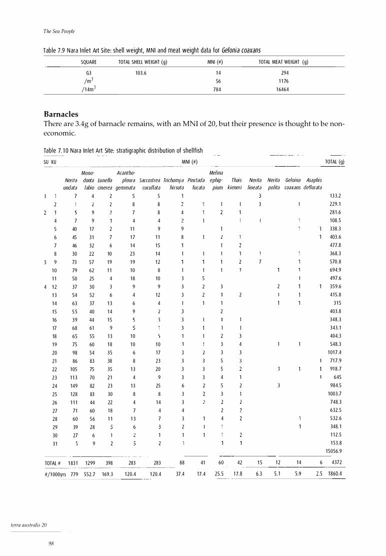
The Sea People
Tab le 7 .9 Nara I n let Art Site: shel l weight, MN I and meat weight data for Gelonia coaxans SQUARE TOTAL SH ELL WEIGHT (g) MNI (#) TOTAL MEAT WEIGHT (g)
G3 1 03 .6 1 4 294
/m3 56 1 1 76
/1 4m3 784 1 6464
Barnacles There are 3.4g of barnacle remains, with an MNI of 20, but their presence is thought to be non-economic.
Tab le 7 . 1 0 Nara In let Art Site: strat igraph ic d i stri but ion of she l l f ish -------- -
SU XU MNI (#) TOTAL (g) ---------------------·--·-------··---- - - · - - · - -
Mono- Acantho- Melina
Neri ta donta Lune/la pleura Saccostrea Trichomya Pinctada ephip- Thais Neri ta Neri ta Geloina Asa phis
undata labia cinerea gemmata cucul/ata hirsuta fucata pi um kieneri lineata polita coaxans def/orata
7 4 2 5 5 1 3 3.2
2 8 8 3 229 . 1
9 7 8 4 281 .6
4 7 9 4 4 1 08 .5
5 40 1 7 2 1 1 9 9 338.3
6 45 3 1 7 1 7 1 1 8 403. 6
7 46 32 6 1 4 1 5 477.8
8 30 22 10 23 1 4 1 368.3
9 73 57 1 9 1 9 1 2 2 7 570 .8
1 0 79 62 1 1 1 0 8 694.9
1 1 50 25 4 1 8 1 0 3 5 497.6
4 1 2 37 30 3 9 9 3 2 3 2 359.6
1 3 54 52 6 4 1 2 3 2 2 41 5 .8
1 4 63 37 1 3 6 4 1 1 3 1 5
1 5 5 5 40 1 4 9 2 403 .8
1 6 39 44 1 5 3 348.3
17 68 61 9 3 343 . 1
18 65 55 1 3 1 0 1 2 3 404.3
1 9 75 60 1 8 1 0 1 0 3 4 548.3
20 98 54 35 6 1 7 3 3 1 01 7.4
21 86 83 38 8 23 3 3 5 71 7 .9
22 1 05 75 35 1 3 20 3 3 5 91 8 .7
23 1 1 3 70 2 1 4 9 3 3 4 1 645
24 1 49 82 23 1 3 25 6 2 5 2 3 984.5
25 1 28 83 30 8 8 3 3 1 003 .7
26 1 1 1 44 22 4 1 4 3 748.3
27 71 60 1 8 7 4 4 2 632 .5
28 60 56 1 1 1 3 7 3 4 532 .6
29 39 28 6 2 348. 1
30 27 6 1 1 1 2 .5
3 1 9 2 1 53 .8
1 5056.9
TOTAL # 1 83 1 1 299 398 283 283 88 41 60 42 1 5 1 2 1 4 6 4372 ------------�-----------------
#/1 000yrs 779 552 .7 1 69 .3 1 20.4 1 20.4 37.4 1 7.4 25 .5 1 7.8 6.3 5 . 1 5.9 2.5 1 860.4
tcrra australis 20
98

Nara Inlet Art Site, Hook Island
Fish Fish bone is present in all XU of Square G3, with a total weight of 99.Sg, which is 10.9% of the total bone weight. It is distributed relatively evenly throughout the sequence, with the bulk of the material in SU4 (Table 7. 11 ) .
Tab le 7 . 1 1 Nara I n let Art S i te : strat igraphic d istribut ion of other cu l tura l materi a l by weight or number
SU XU F ISH BONE (g) TERR. BONE (g) TU RTLE BON E (g) CRAB SHELL (g) CHARCOAL (g) STONE ARTEFACTS (#)
1 .94 2 .30 0. 1 5 41 .8 2
2 2 .36 1 .57 0.28 3 1 . 5 2
2 3 1 .03 4.90 0.40 28.8
4 1 .89 0 .30 1 8 .8
2 .52 9 .43 0 .7 0.41 54.8 4
6 1 .57 1 7 .50 0 . 1 0 .59 57 .3 4
7 3 .20 26.20 2 .07 55 .8 4
8 2 . 1 8 1 7.90 1 . 1 9 50.0 2
9 2 .99 1 7 .90 1 . 1 9 86.3 2
1 0 4.22 23 . 1 0 0.90 92.0 1 3
1 1 4.72 3 1 .30 1 .2 1 .72 1 90 .0 4
4 1 2 6.1 3 1 7.70 2.9 0.31 89.6 1 6
1 3 2 .76 2 1 . 1 0 0.36 76.7
1 4 5 .56 25.50 1 .3 0.07 55.9 3
1 5 2 .58 1 0. 70 0 . 1 1 . 1 8 50.2 6
1 6 5.82 2 1 .00 0 .7 0 .74 37.5 4
1 7 3 .96 24.90 2 .00 49.9 7
1 8 3 .96 1 9 .20 1 .0 1 . 76 3 7.9 10
1 9 3 .64 48.40 0.71 2 1 . 1 2
20 2 .62 71 .30 0.3 1 .50 32.2 4
2 1 5 .05 80.30 1 .6 1 .20 37.7 7
22 3 .75 43.50 1 . 1 0 35 .8 12
23 6 .61 58 .60 2 .92 32 .6 7
24 2 .61 6 1 .30 0 . 1 9 32 . 8 3
25 2 . 1 3 42.60 1 .67 1 5 . 7 4
26 4.46 45.30 2.60 1 3 . 6 6
27 0 .35 22 .90 0.40 1 2 .9 2
28 3 .89 1 5 .80 1 3 . 1
29 2 .04 1 0.70 9.4
30 4.31 5 .77 0.20 5.4
3 1 0.63 3 .40 0 .70 0.6 1 0
TOTALS 99.50 802.90 9.9 2 8.80 1 367.7 1 47
D iscard/1 OOOyrs 42.3 341 .7 4.2 1 2 . 3 582.0 62.6 -- ----
Only one taxon was identified, with only one individual belonging to it. This was one of the wrasses (Labridae), probably a medium to small species such as Cheilinus fasciatus . Otoliths from an unidentified fish, the same unidentified species as was found in Nara Inlet 1, were also present.
A conservative MNI for Square G3 is 14 fish, arrived at on the basis of vertebrae since only one individual could be specifically identified. Thus, XUS has 1 7 fish vertebrae, ranging in size from 9.9mm, measured across the centrum, to l .2mm, clearly establishing the presence of at least two separate individuals. Vertebrae of similar sizes that were separated by at least two excavation units were also counted as separate individuals (see discussion in the section in Chapter 5 headed MNifor fish).
terra australis 20
99

The Sea People
The overall size of vertebrae ranged from a maximum of 9 .9mm to l . l mm, and although they are all treated as economic, it is possible that some of the very small vertebrae may have been stomach contents of the larger fish consumed at the site . The average centrum size was 4.86mm, showing that unlike those at the Nara Inlet 1 shelter, the fish from the art site were medium to small in size.
The fact that only one individual was identified to species level makes the calculation of meat weights for fish problematic. Nevertheless, the weight of the fish bone (99 .Sg) is well above the average weight for the other excavated sites overall. It is thus considered that fish were at least equivalent in dietary importance at this site to other sites in the region. Given the relatively small sizes of vertebrae, meat weight for each individual was probably not great. A figure of 500g of meat per fish for an estimated MNI of 14 would mean that 7.0kg were represented in Square G3, or 28kg per m3 . This translates into 392kg for the site as a whole over the 2350 years of its occupation.
Crustaceans Five species of crabs with identified, with a total shell weight of 28.Sg (Table 7 .11 ) . These are mud crabs (Scylla serra ta), sand crabs (Portunus pelagicus), trawl crabs (Thalamita sima), Thalamita cremata and Myomenippe forn isinii (Table 7 .12). Thalamita sima, the most common species present, is a small ubiquitous species measuring just 60mm across its shell, which is frequently sighted in Nara Inlet today. This species would be easily obtainable in relatively large quantities in the local area.
Tab le 7.1 2 Nara I n let Art Site: strati graph ic d istr ibut ion of crustaceans - ·· -- --- --
SU XU Scylla serrata Portunus pe/agicus Thalamita sima Tha/amita cremata Myomenippe fornisinii
6 x
2 7 x
2 8 x
3 1 0 x x
1 1 x
4 1 5 x
4 1 7 x x
4 1 8 x
4 20 x x
4 2 1 x
4 23 x
4 26 x x x -�-------- ----------
Scylla serrata, the largest of the crab species present, is a significant resource, providing up to 500g of meat per individual . It is considered that this mud-dwelling and mangrove-dependent species is most likely to have been procured outside Nara Inlet, which has very sparse and relatively open mangrove communities today. Mud crabs, like turtles, are well suited to live storage and it is possible to keep them alive for up to a week in captivity.
The sand crab, Portun us pelagicus, is also unlikely to have been readily available in Nara Inlet, which is a rocky-shore I rock-platform environment with little or no beach fringe.
Marine turtle Turtle bone weighed 9.9g in Square G3 (Table 7. 1 1 ), which is 1 .39% of the total bone weight.
Turtles were identified from small but distinctive fragments of bone from the lower skeleton, but identifiable skeletal components for MNI calculations were not present in Square
terra australis 20
1 00
Nara !11/et Art Site, Hook lsln11d
G3. Turtle bone was, however, present in 10 XU and where these were separated by at least two XU, they were considered separate individuals (see discussion in Chapter 5 on Calculating MNI from bone). This gave an MNI of five individuals in Square G3 . Because of the potential for a relatively wide horizontal distribution within a site of bone belonging to a single individual of these large species, the MNI of five from the single 50 x 50cm square under analysis was taken by convention (again see the section in Chapter 5 on Calculating MNI from bone) to be the MNI of one square metre . Since the maximum depth of the excavated square was, at just less than 90cm, close to lm, MNI was, again by convention, reckoned to be five per cubic metre . The estimated MNI of five was considered reasonable, given the relatively frequent occurrence and even distribution of the bone fragments through the sequence.
While species identification was not possible for reasons discussed above, the thickness of the bone suggested that they were all from the green sea turtle, Chelon ia mydas, which can supply 60kg of meat. If so, a potential meat return of 300kg is indicated for Square G3, or 4200kg for the entire site, based on 300kg per m3 .
Other marine fauna There were spines from sea urchins in XU22 of SU4. The species represented is unknown.
Terrestrial fauna Bone from terrestrial fauna makes up the major component of bone weights in the analysed square, 802.9g, which is 87.9% of the total . The bulk of it occurs in SU4 (Table 7. 11 ) . The quantities of terrestrial bone at the site far exceed the total weight of terrestrial fauna in all other sites combined.
More than 90% of the terrestrial bone by weight comes from the small macropod, Petrogale inornata, the unadorned rock wallaby. Other terrestrial species include the rodent, Melomys cervinipes, the python, Morelia sp., a goanna (Varanidae), a small lizard (Agamid ae) and bird remains (unidentified).
Petrogale inornata has an average body weight of 4.3kg and a meat return of two-thirds of this, or 2 .8kg. On this basis, the seven wallabies present in Square G3 would potentially provide 19.6kg of meat or 274.4kg over the entire site, based on 19 .6kg per m3 . Rodent bones were present throughout the sequence (MNI = 10) . The python, Morelia spp. is sporadically present in various XU, with a total MNI of four. Goanna is present in XUlO (MNI = 1 ), while small lizards are present in all excavation units (MNI = 12) . It is thought that some of the rodents and small lizards may not necessarily be attributable to human predation (Brian 1994). There are rodent teeth marks on bones found in the site, demonstrating post-depositional scavenging (see Brian 1994). The bird bone from XU6 and XU19 was not identified further.
The above species occurred sporadically throughout the sequence and did not reveal any obvious temporal patterns.
Plant material A range of plant remains were present including wood, sticks, bark, grass, roots, seeds, nuts and nutshells. The summer-fruiting tropical Burdekin plum, Pleiogynium timorense, identified from its distinctive and robust pit, occurred spasmodically throughout the sequence, down to XU21 . The poisonous cycad, Cycas media, was present after XU7 (Table 7. 13) .
term aus tralis 20
1 01

The Sea People
Tab le 7 .1 3 Nara I n let Art Site: strat ig raph ic d istrib ut ion of ed ib le p la nts
Land snails
SU
1
2
2
4
4
XU
4
6
7
1 1
1 6
2 1
PLEIOGYN/UM TIMORENSE
x
x
x
x
x
CYCAS MEDIA
x
x
x
Land snails, with an MNI of 37 in Square C3 and a \veight of 1 42 .9kg, are di stributed throu ghou t the sequence. As at Nara I n le t 1, only one species was identified, the la rge, closedforest vine-thi cket species, Bcn tos i tcs mnc!cayi . This species, which prefers wet conditions, is extan t in th e region today. It is present in n early every XU, but whether n aturally or as a resource is unclear.
Lithic artefacts Detailed analysis of the stone artefacts from Squ are G3 has not been carried out . Preliminary results, however, show that, as with a l l the other stone assemblages analysed from the region, black tuff like that from the Sou th Moll e Island qu arry predominates (see Chapter 1 0) . Stone artefacts number 147, with an overall weight of 1 88.9g and an average weight of 0 .77g / artefact. The mean discard rate is 62.6 a rtefacts per 1 000 years (Table 7.1 1 ) .
Non-lithic artefacts Only two non-l i thic artefacts were fou nd in Square G3. They are both pieces of Geloina coaxans shell with eviden ce of use-wear I polishing on one or more edges. Both were found in XUl 0 .
Other cultural material Charcoal is present through out the sequence. Charcoal densi ties are lowest in SU4 (Table 7. 1 1 ) .
Rock art and ochre A feature of the Nara Inlet Art Site is the large body of rock art present on nearly every avai l able wal l surface. Al ong with other rock art found at Nara Inlet, there has been local controversy as to its authentici ty, as discussed below. Walsh (1985) describes the art as nonfi gurative, consisting of freehand motifs with no evidence of engravings or conventional stenci ls . The predomi nant colours are white and red, with designs consisting mainly of net patterns, lines and other non-figurati ve motifs (Plate 7 .2) . According to Walsh (1 985), net or grid motifs dominate at the Na ra Inlet sites and generally bear a closer affinity to the central Queensl and ' net' art than to any other regional body of Australian art. It is apparent that this art is quite unlike the figurative art present on i slands fu rther to the north, such as Dunk Island, or the Flinders Group fu rther afield . It is also di ssimilar to the nearest mainland body of art, west of Proserpine (Brayshaw 1 990 :46 ) .
Although small quantities o f ochrous material were present i n the sequence, no pieces were found with striations or facets indicating their use as crayons . During the excavation of the art site in 1990, a rock art conservator, Kathryn Sale, was enlisted to record the art and, at the request of QNPWS, to investigate the authenticity of its purported prehistoric Aboriginal origins (Sale and B arker 1 991 ) . To this end, a number of small ochre samples from seven paintings within the shelter were collected, as well as samples from two
term nustmlis 20
1 02
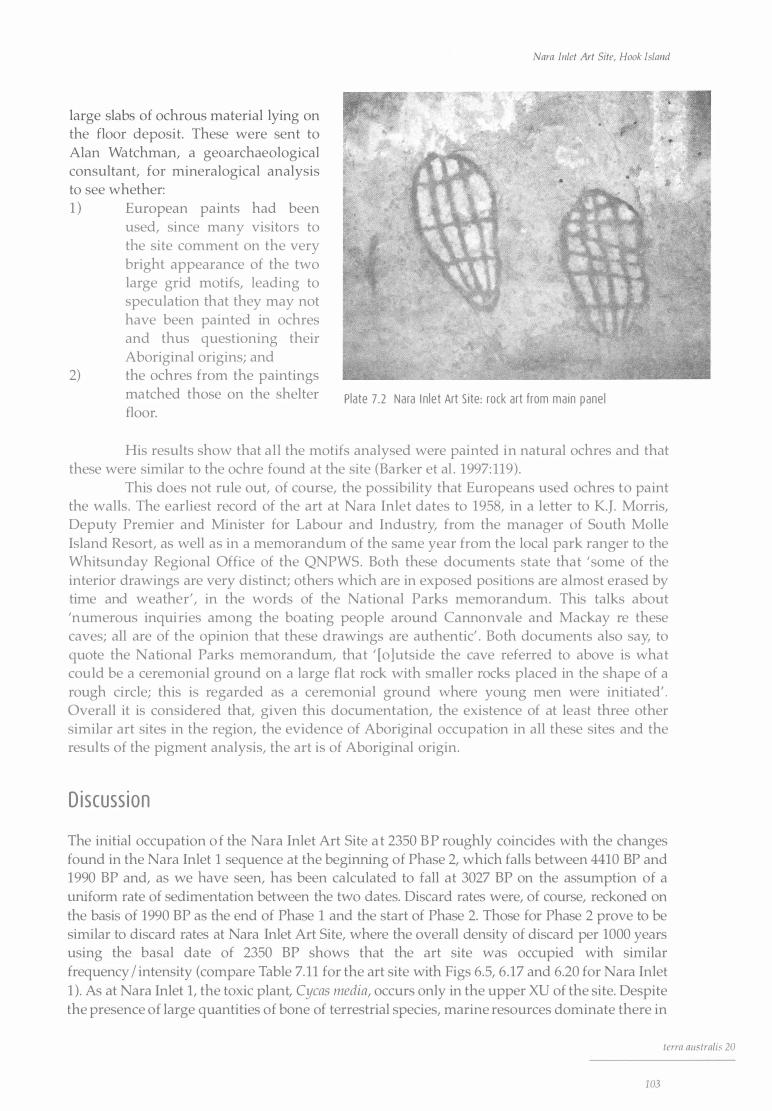
large slabs of ochrous material lying on the floor deposit. These were sent to Alan Watchman, a geoarchaeological consultant, for mineralogical analysis to see whether: 1 ) European paints had been
used, since many visitors to the site comment on the very bright appearance of the two large grid motifs, leading to speculation that they may not have been painted in ochres and thus questioning their Aboriginal origins; and
2) the ochres from the paintings matched those on the shelter floor.
Nara Inlet Art Site, Hook Island
Plate 7 .2 Nara I n let Art S ite: rock art from main pane l
His results show that all the motifs analysed were painted in natural ochres and that these were similar to the ochre found at the site (Barker et al . 1997: 119) .
This does not rule out, of course, the possibility that Europeans used ochres to paint the walls. The earliest record of the art at Nara Inlet dates to 1958, in a letter to K.J. Morris, Deputy Premier and Minister for Labour and Industry, from the manager of South Molle Island Resort, as well as in a memorandum of the same year from the local park ranger to the Whitsunday Regional Office of the QNPWS. Both these documents state that 'some of the interior drawings are very distinct; others which are in exposed positions are almost erased by time and weather', in the words of the National Parks memorandum. This talks about 'numerous inquiries among the boating people around Cannonvale and Mackay re these caves; all are of the opinion that these drawings are authentic' . Both documents also say, to quote the National Parks memorandum, that ' [ o ]utside the cave referred to above is what could be a ceremonial ground on a large flat rock with smaller rocks placed in the shape of a rough circle; this is regarded as a ceremonial ground where young men were initiated' . Overall it is considered that, given this documentation, the existence of at least three other similar art sites in the region, the evidence of Aboriginal occupation in all these sites and the results of the pigment analysis, the art is of Aboriginal origin.
D iscuss ion
The initial occupation o f the Nara Inlet Art Site a t 2350 B P roughly coincides with the changes found in the Nara Inlet 1 sequence at the beginning of Phase 2, which falls between 4410 BP and 1990 BP and, as we have seen, has been calculated to fall at 3027 BP on the assumption of a uniform rate of sedimentation between the two dates. Discard rates were, of course, reckoned on the basis of 1990 BP as the end of Phase 1 and the start of Phase 2. Those for Phase 2 prove to be similar to discard rates at Nara Inlet Art Site, where the overall density of discard per 1000 years using the basal date of 2350 BP shows that the art site was occupied with similar frequency I intensity (compare Table 7. 11 for the art site with Figs 6.5, 6 .17 and 6.20 for Nara Inlet 1 ). As at Nara Inlet 1, the toxic plant, Cycas media, occurs only in the upper XU of the site. Despite the presence of large quantities of bone of terrestrial species, marine resources dominate there in
terrn australis 20
1 03

The Sea People
terms of meat weights, especially turtle. Weight of fish bone is greater at the art site than at Nara Inlet 1, but meat weights come out greater for the latter because of the difficulties in species identification at the art site and therefore calculation of MNI. Given the relatively high density of fish bone discard at the art site, however, it is reasonable to assume that similar quantities of fish are present. It would also appear that the art site has a smaller average size of fish. Chitons predominate among the shellfish, providing 47.7% of total shellfish meat, followed by nerites with 17.5%, top shell with 13.9% and oyster with 1 0.7% . A stone artefact discard rate of 62.6 artefacts per 1000 years (Table 7. 1 1 ) closely corresponds to Phase 2 of Nara Inlet 1 (Fig. 6.20) .
Although occupied contemporaneously with the later phase of Nara Inlet 1, just 400m across the inlet, it is apparent that the Nara Inlet Art Site differs somewhat in its fauna! assemblage. In particular, it has two species of nerite, Nerita lineata and N. polita, and one species of crab, Myomenippe fornisin ii, which are absent from Nara Inlet 1, as well as a far greater number and higher rate of discard of the macropod Petrogale inornata . As the availability of this is not subject to great seasonal variation, it can only be assumed that somewhat different activities were being carried out in the two shelters . This is also evident from the large body of rock art at the art site and the possible presence of a stone arrangement.
ft'IT£7 austmlis 20
1 04

Border Island 1
Reg iona l Descr i pt i on
Border Island (Plate 8 .1 ) i s located 4km to the east of Whitsunday Island. I t has a n area o f 388 .5 hectares and a maximum length of 3km. The island is a hi gh, rocky mass, sparsely soiled, with precipitous cliffs and a well-embayed shoreline. The rocky southern coast is exposed to prevailing south-easterlies. The northern coast is dominated by Cateran Bay. The eastern coast has a number of small, sheltered, sandy beaches . Vegetation consists of low vine forest, low shrub including acacias, Tristania conferta, Casuarina littoralis and Xan tlwrrhoea spp. and a small area of grassy, open forest with Eucalyptus alba and E. tereticornis among a range of other eucalypt species .
Border I s l and 1 The location of Border Island 1 rock shelter, as of other Whitsunday Islands sites, is not made public and so is not shown on Plate 8 . 1 . It is located on the north-eastern extent of Cateran Bay. This is a large embayment which has a precipitous coastline of 2km with two small areas of beach fringe exposed to wet-season northerlies and is dominated by an extensive fringing reef (700m2 ), exposed at low tide. Border Island 1 is about 30m directly above the high-water mark, set in a rock cliff with a westerly aspect (Plate 8.2). There is no beach fringe or rock platform at the tidal interface and access to the shelter is moderately difficult, involving a steep climb.
The site plan was lost overboard and there was no opportunity subsequentl y to redo it. The shelter i s, however, large, with dimensions of 1 8m across the entrance, divided into two smaller openings of Sm and 7m and is 1 7m from the dripline into the furthest extent of the shelter (Plate 8 .3) . The shelter floor and the dripline coincide with the cliff edge. The total floor area of the shelter is approximately 25m2, but cultural deposits extend over only about 12m2, with an estimated volume of 5m3 •
The surface of the cultural deposit was a fairly loose, fine, grey dust exhibiting shellfish, bone (including turtle bone) and stone artefacts . Evidence of some post-depositional
term australis 20
1 05
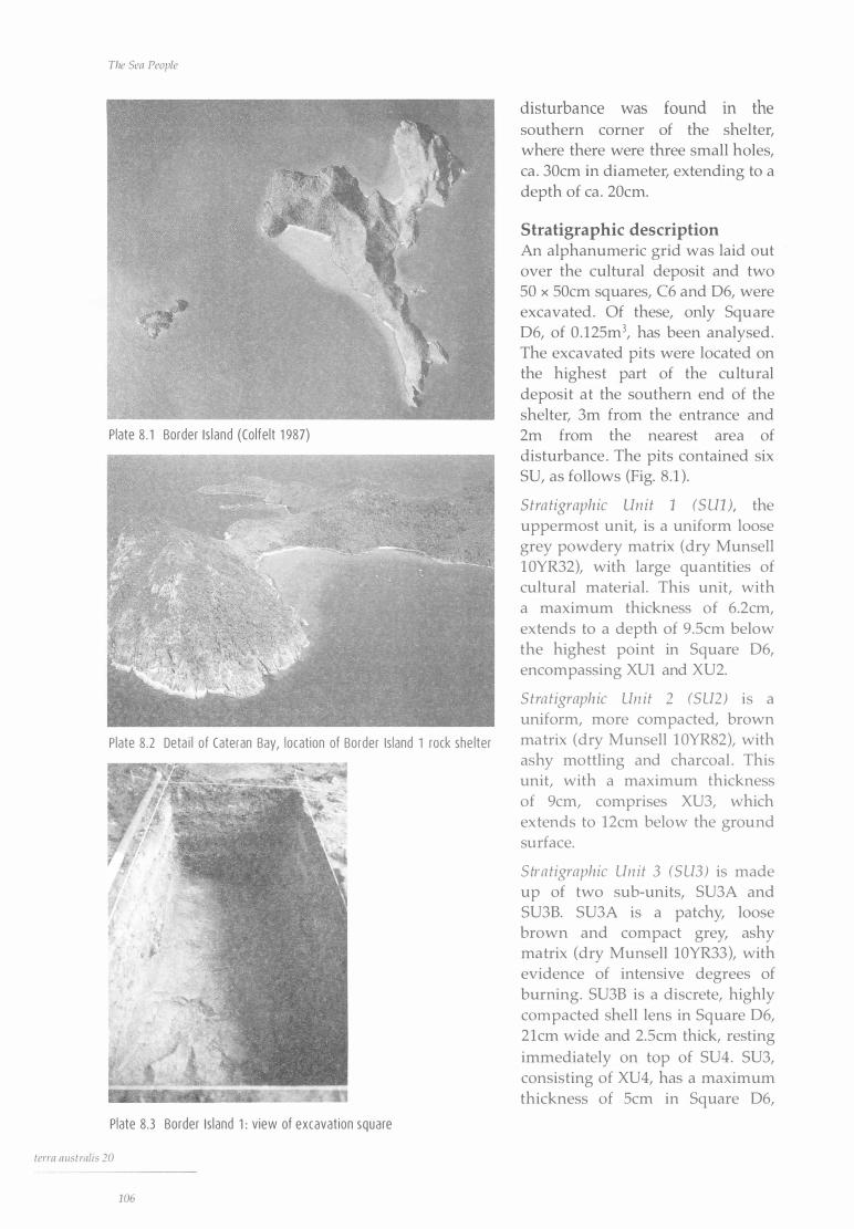
The Sea People
Plate 8 . 1 Border I s land (Colfe lt 1 987)
Plate 8.2 Deta i l of Cateran Bay, locat ion of Border Is land 1 rock she lter
Plate 8.3 Border Is land 1 : view of excavat ion square
terra a1 1strnlis 20
1 06
disturbance was found in the southern corner of the shelter, where there were three small holes, ea . 30cm in diameter, extending to a depth of ea . 20cm.
Stratigraphic description An alphanumeric grid was laid out over the cultural deposit and two 50 x 50cm squares, C6 and D6, were excavated . Of these, only Square D6, of 0 . 125m3, has been analysed . The excavated pits were located on the highest part of the cultural deposit at the southern end of the shelter, 3m from the entrance and 2m from the nearest area of disturbance . The pits contained six SU, as follows (Fig. 8 .1 ) .
Stra tigraphic Unit 1 (S UV, the uppermost unit, is a uniform loose grey powdery matrix (dry Munsell 1 0YR32), with large quantities of cultural material. This unit, with a maximum thickness of 6.2cm, extends to a depth of 9 .Scm below the highest point in Square D6, encompassing XUl and XU2.
Stra tigraphic Un it 2 (SU2) is a uniform, more compacted, brown matrix (dry Munsell 1 0YR82), with ashy mottling and charcoal . This unit, with a maximum thickness of 9cm, comprises XU3, which extends to 12cm below the ground surface.
Stra tigraphic Un it 3 (SU3) is made up of two sub-units, SU3A and SU3B. SU3A is a patchy, loose brown and compact grey, ashy matrix (dry Munsell 10YR33), with evidence of intensive degrees of burning. SU3B is a discrete, highly compacted shell lens in Square D6, 21cm wide and 2.Scm thick, resting immediately on top of SU4. SU3, consisting of XU4, has a maximum thickness of Scm in Square D6,
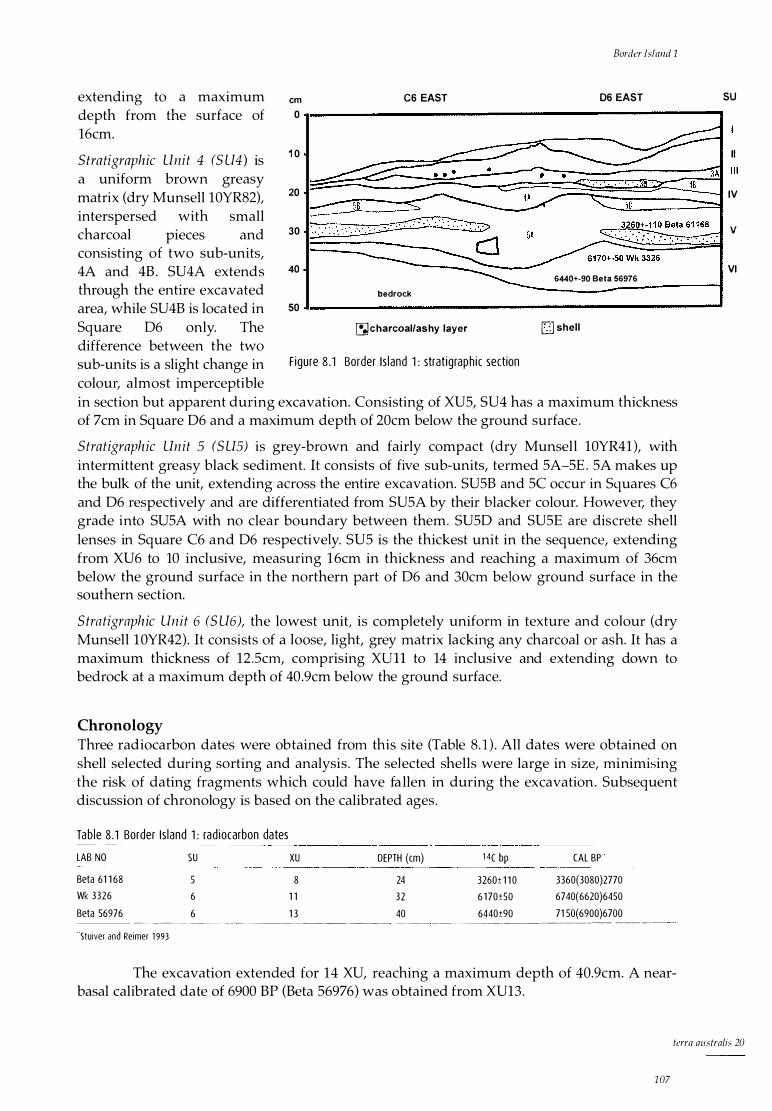
extending to a maximum cm C6 EAST depth from the surface of 0 16cm.
Stratigraphic Unit 4 (S U4) is 1 0
a uniform brown greasy matrix (dry Munsell 10YR82), 20 interspersed with small charcoal pieces and 30 consisting of two sub-units, 4A and 4B . SU4A extends 40 through the entire excavated bedrock
area, while SU4B is located in 50 Square D6 only. The �charcoal/ashy layer difference between the two sub-units is a slight change in F igure 8 . 1 Border Is land 1 : strat igraph i c section
colour, almost imperceptible
Border Island 1
06 EAST
6440+-90 Beta 56976
[] shell
in section but apparent during excavation. Consisting of XUS, SU4 has a maximum thickness of 7cm in Square D6 and a maximum depth of 20cm below the ground surface .
Stratigraphic Unit 5 (S US) is grey-brown and fairly compact (dry Munsell 10YR41 ), with intermittent greasy black sediment. It consists of five sub-units, termed SA-SE . SA makes up the bulk of the unit, extending across the entire excavation. SUSB and SC occur in Squares C6 and D6 respectively and are differentiated from SUSA by their blacker colour. However, they grade into SUSA with no clear boundary between them. SUSD and SUSE are discrete shell lenses in Square C6 and D6 respectively. SUS is the thickest unit in the sequence, extending from XU6 to 10 inclusive, measuring 1 6cm in thickness and reaching a maximum of 36cm below the ground surface in the northern part of D6 and 30cm below ground surface in the southern section.
Stratigraphic Un it 6 (S U6), the lowest unit, is completely uniform in texture an d colour (dry Munsell 1 0YR42). It consists of a loose, light, grey matrix lacking any charcoal or ash. It has a maximum thickness of 12 .Scm, comprising XUll to 14 inclusive and extending down to bedrock at a maximum depth of 40 .9cm below the ground surface.
Chronology Three radiocarbon dates were obtained from this site (Table 8. 1 ) . All dates were obtained on shell selected during sorting and analysis . The selected shells were large in size, minimising the risk of dating fragments which could have fa llen in during the excavation. Subsequent discussion of chronology is based on the calibrated ages .
Tab le 8 .1 Border I s land 1 : rad iocarbon dates
LAB NO
Beta 61 1 68
Wk 3326
Beta 56976
SU XU DEPTH (cm) 1 4( bp
5 8 24 3260± 1 1 0
6 1 1 32 6 1 70±50
6 1 3 40 6440±90 ---�--- - -- ----- ---------- ----- - ---------
Stuiver and Reimer 1 993
CAL BP'
3360(3080)2770
67 40( 6620)6450
71 50( 6900 )6 700 --------- ----- --- -
The excavation extended for 14 XU, reaching a maximum depth of 40.9cm. A nearbasal calibrated date of 6900 BP (Beta S6976) was obtained from XU13.
SU
II
IV
v
VI
tcrra australis 20
1 07

The Sea People
0
0-3080
0.. 3080-6620 co
V> ro (],) >- 6620-6900
200
g/1 000yrs
400 600 800
F igure 8 .2 Border I s land 1 : d iscard of she l l, g/1 OOOyrs
MNl/1 000yrs
1 000 1 200
0 50 1 00 1 50
o-3080 _ I � 3080-6620
� _ _ _____ __J_�--�_ . _____L __ __J
V> ro 1-----1 � 6620-6900 J __ _J
F igure 8 .3 Border I s land 1 : d i scard of Nerita undata, MN l/1 OOOyrs
MNl/1 OOOyrs
0 5 10 1 5 20 I -----�I _
_
_ _ _____ _;__ _ _ _ _ _____________ L_ ---0-3080
-r--
� 3080-6620 I � 6620-6900 b
F igure 8.4 Border I s l and 1 : d i s ca rd of Monodonta labia, MN l/1 OOOyrs
MNl/1 OOOyrs
20 40 60 80 1 00 1 20 j__ _ _ _ _ l_ _ -- --- � - - - _ !_
0-3080 !--'---------' � 3080-6620
- � ro (],) 1--------------�
>- 6620-6900
8.5 Border I s land 1 : d i scard of Lune/la cinerea, MN l/1 OOOyrs
MNl/1 OOOyrs
- - __ J
0 20 40 60 80 1 00 1 20 140
0-3080_ b _
_
I - -
_ _ _L --- _l - - - l - __ J_ --
� 3080-6620 - p � 6620-6900 !-------------------,
Fig ure 8 .6 Border I s land 1 : d i scard of Acanthopleura gemmata, MN l/1 OOOyrs
term australis 20
1 08
There was a major drop in discard rates of cultural materials after XUll (Figs 8.2-8.11 ). A sample to date this change taken from the top of XUll, 3cm below the stratigraphic change from SU6 to SU5, gave a calibrated age of 6620 BP (Wk 3326).
Discard rates increased sharply after XU8 (Figs 8.2-8. 1 0). A calibrated date for this, on a sample collected 5cm above the boundary between SU5 and 6, is 3080 BP (Beta 61168).
Only 8cm of deposit separate XUl 4 at 6900 BP and XUll at 6620 BP, a period of some 280 years with a mean sedimentation rate of 2.8cm per 1 00 years. SU6, between XU14 and 11, thus represents a brief period of early occupation, known as Phase 1 . It is possible that the relatively high cultural discard rate during this phase reflects a single event.
There are 8cm of sediment between XU11 near the top of SU 6 at 6620 BP and XU8 near the bottom of SU5 at 3080 BP, a total of 3540 years, representing a drop in the rate of sediment deposi tion to 0.23cm per 100 years from the previous 2 .8cm per 100 years. XUl O and 9, which make up this interval, would thus be an intermediate period representing either a hiatus in occupation or merely ephemeral visitation. I argue that evidence of continued visitation is provided by the 8cm of cultural deposit during the period in question, although it cannot be ruled out that taphonomic factors such as treadage may have been responsible for the presence of cultural material in these two XU.
The marked increase in cultural deposition from XU8 to the top of the site constitutes Phase 2, beginning at 3080 BP. This phase coincides in time with Phase 2 at Nara Inlet 1, for which a date of 3027 BP has been calculated on the assumption of

a uniform rate of sedimentation, as well as the span of occupation at the Nara Inlet Art Site, from 2350 BP, and Hill Inlet Rock Shelter 1, from 2770 BP. Unlike these other sites, however, where there is a marked reduction in the discard of cultural material in the top three or four XU, coinciding with the appearance of European items such as bottle glass, there are no European items in the top of Border Island 1 and the discard rate of cultural material continues to increase to the surface . While this suggests that occupation at the site ceased sometime prior to European contact or was so sporadic during the contact period as to be archaeologically invisible, for the purpose of calculating discard rates through time, the top of the site is treated as modern, as explained in the section on Methods of
quantification in Chapter 5 . Overall, the Border Island
rock shelter demonstrates very low intensity of use, with rates of sedimentation and discard of cultural materials far below those found in the other sites.
Ana lys is of Cu l t u ra l Materi a l
Discard rates of cultural material were calculated between known dates as Minimum Numbers of Individuals (MNI) or grams (g) per 1000 years .
Shellfish The bulk of the cultural material is shell, making up 79.3% by weight in Square D6. The shellfish assemblage comprises predominantly the rockplatform gastropods common to other sites in the region, including nerites, turban shell and top shell. Chiton is also common, as is oyster,
0
0-3080
a... 3080-6620 co
Vl ro CJ >- 6620-6900
Border Island 1
MNl/1 OOOyrs
10 15 20 25 30
F igu re 8. 7 Border I s l and 1 : d iscard of Saccostrea cucul/ata, MNl/1 OOOyrs
0-3080
� 3080-6620 Vl ro
� 6620-6900
50
g/1 000yrs
100 150 200 _l_______ ______ _ l ___ _ j
F igu re 8 .8 Border Is land 1 : d iscard of f ish bone, g/1 OOOyrs
g/1 000yrs
0 20 40 60 80
0-3080
_
:£ --n1 T ____ L_
_
_ __ l___ _
__ _ _ _ J
� 3080-6620 ::;; CJ
>- 6620-6900
Figu re 8 .9 Border I s land 1 : d i scard of turt le bone, g/1 000yrs
0-3080
g/1000yrs
0 5 10 15 20 25 30 __j__ __ J__ __ �I ___ ____l___ __L_ ____ _j_ ___ J
L--�������������.......J � 3080-6620 --� - .
� 6620-6900 _
_t====J F igure 8 .1 o Border I s l and 1 : d iscard of charcoa l, g/1 OOOyrs
#/1000yrs
O 200 400 600 800 1 OOO 1 200 - _ __ L _
_
__i ___ l_ _ ___ L_ __
__ L__ J 0-3080
� 3080-6620 Vl ::;; � 6620-6900
F igure 8.1 1 Border I s land 1 : d i scard of stone a rtefacts, # /1 OOOyrs
tcrra australis 20
109

The Sen People
the only bivalve species. Discard rates increase significantly after 3080 BP (Fig. 8.2) .
Nerites Three nerite species are present in Square D6, with Nerita undata being the most common (MNI = 445), followed by N. pali ta (MNI = 52) and N. lineata (MNI = 32). Generally, all the nerites increase in number exponentially through time, although discard of N. undata decreases after 6620 BP before increasing significantly after 3080 BP. Overall, nerite discard is insignificant until after 3080 BP (Fig. 8 .3) . Nerita linea ta and N. palita are present in much smaller numbers than N. undata, although they follow similar trends.
Table 8.2 registers a NMI of 529 for all three nerite species combined in Square D6. If we apply the 3.lg average shell weight of Nerita undata to the other two nerites, the combined MNI of 529 gives a total shell weight of 1 639 .9g, 693 .5g less than the shell weight in the analysed square . This allows for an additional 224 nerites to be present, making the Number of Individuals Based on Weight (NIBW) 753. Assuming that the individual meat weight of 1 .2g for N. undata applies to the other two species, there is a total meat weight of 903.6g for the square, 7228.8g for a cubic metre of deposit and just more than 36kg for the estimated 5m3 of deposit at the site. Phase 2 (post-3080 BP) accounts for 97.9% of this total .
Ta b le 8 .2 Border Is land 1 : she l l weight, MN I, N I Bw··'' and meat weight data for th ree nerites ------ -----SQUARE TOTAL SHELL MN I N I BW._,, TOTAL MEAT MEAT WE IGHT MEAT WE IGHT
PHASE 2 (g ) WEIGHT (g) (#) (#) WE IGHT (g) PHASE 1 (g) 06 2333.4 529 753 903.6 1 8.8
/m3 4232 6024 7228.8 1 50.4
/5m3 21 1 60 301 20 361 44.0 752.0
' N IBW: Number of Ind ividuals Based on Weight
Top shell
884.8
7078.4
35392.0
The top shell, Manadan ta labia, has a total MNI of just 17 in Square D6. All except one occur after 3080 BP (Fig. 8.4). Discard is constant until XUl, where there is a significant increase.
At an average shell weight per individual of 3 .3g, the MNI of 17 gives a total weight of 56. lg for the species, which is well in excess of the 22.8g recovered from the analysed square (Table 8.3). Meat weights were therefore calculated on the basis of the MNI figure of 1 7 and an average meat weight of 1 .36g per individual . This gives a meat return of 23 . lg for M. labia in Square D6, which translates to 184 .8g per cubic metre of deposit and 924g for the 5m3 of total site deposit (Table 8 .3) . Phase 2 (post-3080 BP) accounts for 94% of this total .
Table 8 .3 Border I s land 1 : she l l weig ht, MNI and meat weig ht data for Monodonta labia
SQUARE
-------- - - -�--- ·-
06
/m3
/5m3
Turban shell
---- -----�--- ·
TOTAL SHELL MN I (#) TOTAL MEAT MEAT WE IGHT WEIGHT (g) WEIGHT (g) PHASE 1 (g)
22.8 17 23 . 1 1 . 4
1 36 1 84.8 1 1 .2
680 924.0 56.0
MEAT WEIGHT PHASE 2 (g)
2 1 .7
1 73 .6
868.0
---
The second most common shellfish species in Square 06 after the nerites is Lunella cinerea (MNI = 219) . It is present in every XU, with highest discard between 6900 and 6620 BP and after 3080 BP (Fig. 8.5) .
At an average shell weight per individual of 4 .74g, 219 Lunella total 1038.06g, but
tcrra nustralis 20
1 1 0
Border Island 1
there are only 231 .8g of the species present in the square (Table 8.4). The MNI figure of 219 is therefore used for meat weight calculation.
Table 8.4 Border I s land 1 : she l l weight, MN I a nd meat weight data for Lune/la cinerea
SQUARE TOTAL SHELL MN I (#) TOTAL MEAT MEAT WEIGHT
06
/m3 /5m3
WEIGHT (g) WEIGHT (g) PHASE 1 (g)
23 1 .8 2 1 9
1 752
8760
343 .8
2750.4
1 3752.0
47 . 1
376.6
1 884.0
MEAT WEIGHT PHASE 2 (g)
296.7
2373.8
1 1 868.0
Based on an average meat weight of 1 .57g per individual and a MNI of 219, there is a meat return of 343.8g for L. cinerea in Square D6, which translates to 2750.4g per cubic metre of deposit and 13,752.0g for the 5m3 of total site deposit (Table 8 .4). Phase 2 (post-3080 BP) accounts for 86.3% of this total.
Thais kieneri This species is rare in Square D6 (MNI of eight), but its discarded remains are almost equally divided between Phases 1 and 2. The MNI of eight gives a total weight of 96g on the basis of an average shell weight per individual of 12g. The total weight of the species in the analysed square is only 57.lg, however, so the MNI figure is used for the meat weight calculation (Table 8.5).
With a meat return of 3.4g per individual, there is 27.2g of meat in D6, which translates to 217.6g per cubic metre of deposit and just more than lkg (1088g) for the 5m3 of total site deposit, 50% in each phase.
Tab le 8.5 Border Is land 1: shel l weight, MN I and meat weight data for Thais kieneri
SQUARE TOTAL SHELL MNI (#) TOTAL MEAT
06
/m3 /5m3
Chi ton
WEIGHT (g) WEIGHT (g) ----
57.1 8
64
320
27.2
2 1 7.6
1 088.0
MEAT WEIGHT PHASE 1 (g)
1 3 .6
1 08.8
544.0
MEAT WE IGHT PHASE 2 (g)
1 3 .6
1 08 .8
544.0
The chiton, Acan thopleura gemmata, is present throughout the sequence in Square D6, with an MNI of 68, which, at an average shell weight of 19g per individual, gives a shell weight total of 1312g, well in excess of what is actually present (Table 8 .6) . Figure 8.6 and Table 8.6 show a pattern of discard and meat weight respectively that is the opposite of that for nerites and top shells and similar to that for oysters. An MNI of 68 and an average meat weight per individual of 21 .5g give a meat return of 1462g for Square D6, which translates into 11,696g per cubic metre of deposit and 58,480g for the 5m3 of total site deposit. Of this total, Phase 2 (post-3080 BP) comprises 47. 1 % .
Tab le 8 .6 Border Is land 1 : shel l weight, MN I a nd meat weight data for Acanthopleura gemmata
SQUARE TOTAL SHELL MN I (#) TOTAL MEAT MEAT WEIGHT
06
/m3 /5m3
WEIGHT (g) WEIGHT (g) PHASE 1 (g)
481 . 1 6 8
544
2720
1 462
1 1 696
58480
773
6 1 84
30920
MEAT WEIGHT PHASE 2 (g)
689
55 12
27560
terra australis 20
1 1 1
The Sea People
Oyster Oysters (Saccostrea cuculla ta) are present but never common in Square D6 (MNI = 27). As with chitons, oysters are much better represented in Phase 1 than in Phase 2 (Fig. 8 .7).
An MNI of 27 and an average meat weight per individual of 4.82g give a meat return for Square D6 of 1 30. lg, which translates into 1041 .lg per cubic metre of deposit and 5205.6g for the 5m3 of total site deposit. Of this total, Phase 2 (post-3080 BP) comprises 51 .9% (Table 8.7).
Tab le �!_��!_d_e_r l_sla_nd_��hel_I w
_e_ig_ht� MN I and meat weig ht data for Saccostrea cucul
_la
_ta __ __ _
SQUARE TOTAL SHELL MN I (#) TOTAL MEAT MEAT WE IGHT
-------
06
/m3
/5m3
Other bivalves
WEIGHT (g) WEIGHT (g) PHASE 1 (g)
256.9 27 1 30 . 1 62 .6
2 1 6 1 041 . 1 500 .8
1 080 5205 .6 2 504.0
MEAT WE IGHT PHASE 2 (g)
67.4
540.3
2701 .5
Other species present are Pinctada fucata (pearl shell), Melina ephippium and Trichornya hirsuta (hairy mussel), all of which are rare. Melina eph ippium and Trichomya h irsu ta occur only in Phase 2 and Pinctada fucata only in Phase 1 .
Barnacles There are two barnacles only, both in XU13 of Phase 1 (6900 BP), probably arriving attached to their hosts .
Fish There are six fish taxa in Square D6 overall, one of which, Scaridae (parrot fish), does not occur in Phase 2 (post-3080 BP), whi le the others are restricted to it (Table 8.8) . These are Lethrinidae (emperors, sweetlip ), Labridae (wrasses, tusk fish), Sillaginidae (whiting), Atherinidae (hardyheads) and an unidentified taxon. There is a total MNI of 1 1 : one in Phase 1, one in the intermediary phase and eight in Phase 2. The weight of fish bone overall is 87.4g.
Tab le 8.8 Border I s land 1 : stratig raph ic di str ibut ion of f ish fam i l ies by MNI
SU
XU
Lethr in idae
S i l l agin idae
Labr idae
Atherin idae
Scar idae
Un identif ied
TOTALS
3
4
2
6 7
5
8 1 0
6
1 2 Tota l
4
2
1 1
Discard rates of fish bone are greater in the early part of the occupation (Phase 1 =
156.5g per 1000 years, Phase 2 = 12 .2g) (Fig. 8.8) . With the exception of whiting and hardyhead, all the fish species are medium to large
warm-water, fringing-reef species, most likely to have been taken by hook and line or spear. Whiting and hardyhead, identified in XU4 and XUl only, are more likely to have been procured by net.
As the fish have been identified only to family level, a range of different species may be present. Calculation of mean fish weight must therefore take this into account. For example,
term austmlis 20
1 12
Border Island 1
there are more than six genera of Scaridae found in Queensland waters, ranging from 3.2kg to 5kg, a mean weight of 4. lkg. Of the Lethrinidae, the most common species in tropical waters is the sweetlip, Lethrinus chrysostomus, attaining a weight of up to 9kg. Other lethrinids are only one-third of this weight. Of the four lethrinid otoliths identified in Square 06, two are from large species such as the sweetlip and two are from smaller species at least half the size . The Labridae include a tusk fish, Choerodon sp., a large reef-dweller, ranging in weight from 4.2kg to 15kg, an average of 9 .6kg. The whiting are all relatively small, averaging about l .2kg in weight in northern waters. Hardyheads are a small school fish attaining a maximum size of 17cm (weights not available). The total estimated weight of fish in Square 06, taken from MNI and averaged across species, comes to 48kg, or a total meat weight of 32kg. This gives a meat return of 256kg per cubic metre of deposit and 1280kg for the total site deposit of 5m3•
Crustaceans Crabs are present in very low densities in Phase 2 only. Total crab shell weight amounts to 3.5g overall . Most of the pieces of shell were so fragmentary and small that positive identification was not possible. However, the thickness of the shell and the tip of a single claw in XUl suggest that the species was probably one of the smaller crabs identified as a resource in other sites, such as Thalami ta s ima at Nara Inlet 1 .
Marine turtle Turtle bone was present in every XU of Square 06 except XU4 (SU3), with a total weight of 105.6g. Most of the pieces were small, flat, thick fragments of the anterior skeleton, with few identifiable skeletal elements except for a rib in XU2 (SU2) and a tarsal in XU9 (SU5). The overall thickness (up to lOmm) of much of the bone suggests that the species present is one of the larger turtles, such as the green turtle ( Chelon ia mydas ), which weighs up to 90kg. Discard rates per 1000 years decrease dramatically after 6620 BP from 74. lg to 3.39g in the intermediate phase, before increasing again at 3080 BP to 24.3g in Phase 2 (Fig. 8.9).
Minimum numbers of individuals were impossible to quantify, although it is clear from the relatively large quantities of bone and its continuous presence (except for XU4) that turtle was an important resource in this site, probably far outweighing all other food resources combined. Although it was stated in Chapter 5, in the section Calculating MNI from bone, that MNI counts on turtle bone would be calculated on the basis of separation by at least two XU, in this case an MNI count from every second XU, treating presence of bone as indicating an individual, was thought to provide a conservative estimate of actual numbers in Border Island 1, giving an MNI of 13 for the square . However, if we stay with MNI from every second XU, there is a count of seven individuals, with a potential total meat return of 420kg in the square, based on 60kg per individual green turtle. Again, by convention established in Chapter 5, this is taken to represent 420kg per cubic metre, which gives a total of 2100kg for the 5m3 of site deposit.
Terrestrial fauna Bone from terrestrial animals occurs in XU4, 5 and 12 only, with a total weight of 1 .3g. Two species were identified, a small snake from a vertebra and a small lizard (Agamidae) from a single dentary element.
Plant material No plant remains were found, with the exception of charcoal and some very small, fine rootlets. It is considered that this is probably not a result of preservation, given the degree of recovery in other sites and a pH range of 8-8.5.
terra australis 20
1 13
The Sea People
Other cultural material
Charcoal Discard rates of charcoal are very low overall, especially in the intermediate phase from 6620 to 3080 BP (Fig. 8 . 10) . Charcoal densities increase significantly after XU8 (3080 BP), with an average of 28.3g per 1 OOO years.
Coral One large and three small pieces of coral were present in XU7, XU4 and XUl of Phase 2, with a total weight of 23.9g. One of these, from XU4, was artefactual and is described below.
Stone artefacts The Border Island rock shelter has more stone artefacts (429) than the other sites and although no analysis has yet been carried out, it is clear from preliminary observations that the assemblage closely resembles that of Nara Inlet 1 . Formal types and cores are absent and the flaked artefacts tend to be small, mainly tertiary pieces of black tuff, all of them likely to be from the South Molle Island quarry some 25km to the south-west.
Discard rates (Fig. 8 .11 ) are significantly greater between 6900 and 6620 BP, with a dramatic decrease between 6620 and 3080 BP and a further decline after 3080 BP, a decreasing trend in stone artefact discard reflecting that of Nara Inlet 1 (Fig. 6.20). Of the 429 artefacts from Border Island, 91 % (391 ) occur between 6900 and 3080 BP, with peak discard rates between 6900 BP and 6620 BP.
The average weight of the artefacts in Phase 1 is 0.69g, being appreciably greater than for Phase 2, where the average weight is 0 .4g.
Other artefacts Other artefacts present comprise a small piece of coral from XU4 (Phase 2) and part of a bone point from XU12 (Phase 1 ) .
The coral piece is broken at one end and rounded and smooth at the other. It measures 7.2mm in length, has a uniform thickness of 8.9mm and is 1 .8g in weight. One side is highly polished and smooth with striations running down its length and there appears to be resin on the rounded end . Its purpose can only be surmised, although references to similar coral artefacts suggest that it may have been used as a file in the manufacture of shell fishhooks (Banfield 1908:268; Roth 1904:v7:33).
The pointed end of the bone point found in XU12 measures 14.2 x 4mm at its widest, with striations and a clear facetted surface evident along its length.
D iscuss ion
Border Island 1 differs from the other shelters excavated in terms o f the low discard rates of most cultural materials . Together with low rates of sedimentation, this suggests that Border Island 1 was never intensively occupied.
As is the case at the other sites, marine resources predominate, with terrestrial fauna being extremely uncommon. Turtles are by far the most important food resource represented. Unlike at Nara Inlet 1, they are present prior to 3080 BP. The limited range of species present overall, the emphasis on turtle and fish and the apparently low intensity of site use may suggest that Border Island 1 was a specialised, perhaps seasonal, hunting camp. Compared with the larger Nara and Hill Inlets and their environs, where a diverse range of natural
ft:rra australis 20
1 1 4
Border Island 1
habitats occurs, Cateran Bay is a relatively small area with a relatively narrow habitat range, in itself unlikely to be able to support long-term occupation.
Although the pattern of occupation at the site indicates comparatively intensive use from 6900 BP until 6620 BP, it could be argued that the discard pattern is somewhat skewed by what could have been a single event, after which a marked reduction in discard of cultural materials and sedimentation rates is apparent until 3080 BP. The period from 3080 BP to the present marks the most intensive phase of occupation, with a substantial increase in nearly all cultural materials except stone artefacts. This pattern is reminiscent of Nara Inlet 1 in that the timing of the major cultural and stratigraphic changes coincides with the establishment of other sites. Although Border Island 1 appears to be never completely abandoned, visitation becomes much more spasmodic and ephemeral between 6620 and 3080 BP. The sea-level data show that the site was probably already an island when it was first occupied about 7000 BP, although occupation may not have occurred until the development of extensive fringing reefs in Cateran Bay. Even during the late Holocene, however, Border Island was clearly on the periphery of the Whitsunday system (see Chapter 11 ) .
terra australis 20
1 1 5

Hill I nlet, Whitsunday I sla nd
Reg i ona l Descr i p t ion
Whitsunday Island is the largest o f the Cumberland Group o f islands (10,935 hectares), with a coastline of 129km (Fig. 9. 1 ) . It is a rugged and largely inaccessible island, dissected by deep gorge-like gullies and situated llkm from the mainland at its nearest point. The north-east side of the island is high and rugged, with sheer plunging cliffs and little or no coastal bench. Extensive fiord-like inlets and bays at Hill Inlet on the south-eastern side, Gulnare Inlet on the south-west and Cid Harbour on the north-west provide large and diverse habitats for a huge range of marine and terrestrial fauna . These three features have a combined coastline of more than 44km and more than 10km2 of mangrove forest. There are numerous small bays and beaches in the south and east of the island, often exposed to the prevailing south-easterly winds. Only Hill Inlet and Gulnare Inlet were extensively surveyed for this study.
Hill Inlet almost bisects the south-eastern part of Whitsunday Island, extending for 6km from its entrance (Plate 9 . 1 ) . It has more than 15km of coastline and about 4km2 of mangrove forest. The distance from the mainland to the entrance of Hill Inlet at the shortest possible crossing is 35km. The mouth of the inlet, facing north-east, is characterised by fine white sand and small sparse mangrove stands and vegetated in the main by Casuarina littoral is . Further up the inlet, muddy sediments enable extensive mangrove forests to flourish, extending in some cases up to lkm from the high-water mark. These mangrove forests are of mixed species, including Bruguiera gymnorh iza, Avicennia marina, Rhizophora s tylosa and at least six other taxa. Above the high-water mark, thick tropical vine forest predominates, interspersed with patches of open eucalypt with an understorey of Pandan us sp., Cycas media and Xantlwrrhoea sp., with solitary Araucaria cunninghamii on thin-soiled rocky outcrops .
The inlet is flanked by steep to sheer rock outcrops along parts of its eastern side, giving way to level areas further in, containing a freshwater swamp and extensive mangroves . The western side of the inlet is less steep and is dominated by a large rocky scarp with a maximum elevation of about 70m. The inlet was created by the drowning of the 'Hill River Valley' sometime between about 9000 and 7000 years ago. Around 9000 years ago the coast was approximately 2km from the present entrance .
term australis 20
1 1 7
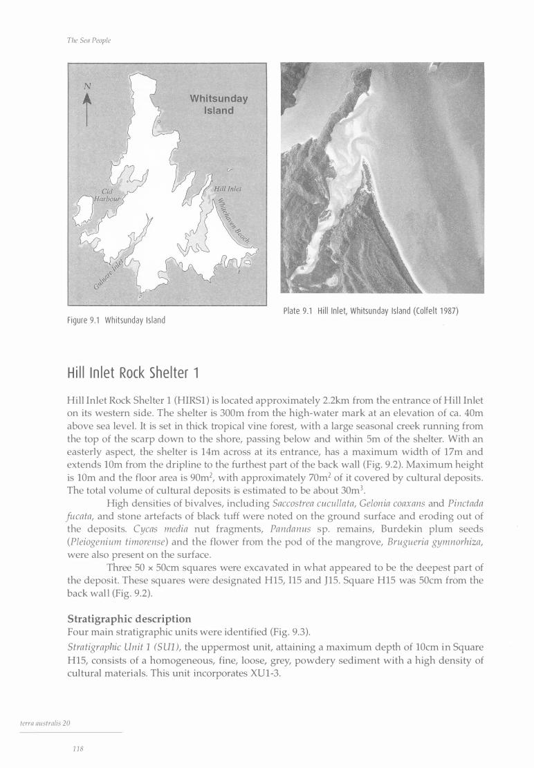
The Sen People
N
I
()
F igure 9 . 1 Wh itsunday Is land
Whitsunday Island
H i l l I n l et Rock She l ter 1
Plate 9.1 H i l l I n l et, Whitsunday Is land (Colfe l t 1 987)
Hill Inlet Rock Shelter 1 (HIRSl ) is located approximately 2 .2km from the entrance of Hill Inlet on its western side . The shelter is 300m from the high-water mark at an elevation of ea . 40m above sea level. It is set in thick tropical vine forest, with a large seasonal creek running from the top of the scarp down to the shore, passing below and within Sm of the shelter. With an easterly aspect, the shelter is 14m across at its entrance, has a maximum width of 17m and extends lOm from the dripline to the furthest part of the back wall (Fig. 9 .2) . Maximum height is lOm and the floor area is 90m2, with approximately 70m2 of it covered by cultural deposits . The total volume of cultural deposits is estimated to be about 30m3 •
High densities of bivalves, including Saccostrea cuculla ta, Gelon ia coaxans and Pinctada fucata, and stone artefacts of black hiff were noted on the ground surface and eroding out of the deposits. Cycas media nut fragments, Pandanus sp. remains, Burdekin plum seeds (Pleiogenium timorense) and the flower from the pod of the mangrove, Brugueria gymnorhiza, were also present on the surface .
Three 50 x 50cm squares were excavated in what appeared to be the deepest part of the deposit. These squares were designated H15, 115 and J15 . Square H15 was 50cm from the back wall (Fig . 9 .2) .
Stratigraphic description Four main stratigraphic units were identified (Fig. 9 .3) .
Stra tigraphic Unit 1 (S Ul ), the uppermost unit, attaining a maximum depth of lOcm in Square H15, consists of a homogeneous, fine, loose, grey, powdery sediment with a high density of cultural materials. This unit incorporates XUl-3.
terra australis 20
1 18
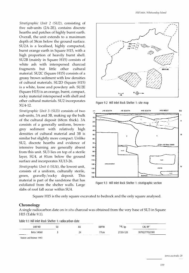
Stra tigraphic Unit 2 (SU2), consisting of five sub-units (2A-2E), contains discrete hearths and patches of highly burnt earth. Overall, the unit extends to a maximum depth of 38cm below the ground surface. SU2A is a localised, highly compacted, burnt orange earth in Square H15, with a high proportion of heavily burnt shell. SU2B (mainly in Square H15) consists of white ash with interspersed charcoal fragments but little other cultural material. SU2C (Square H15) consists of a greasy brown sediment with low densities of cultural materials. SU2D (Square H15) is a white, loose and powdery ash. SU2E (Square H15) is an orange, burnt, compact, rocky material interspersed with shell and other cultural materials. SU2 incorporates XU4-12.
Stratigraphic Un it 3 (S U3) consists of two sub-units, 3A and 3B, making up the bulk of the cultural deposit (68cm thick) . 3A consists of a generally uniform, browngrey sediment with relatively high densities of cultural material and 3B is similar but slightly more compact. Unlike SU2, discrete hearths and evidence of intensive burning are generally absent from this unit. SU3 lies on top of a sterile layer, SU4, at 81cm below the ground surface and incorporates XU13-26.
Stra tigraphic Unit 4 (S U4), the lowest unit, consists of a uniform, culturally sterile, green, gravelly I rocky deposit. This material is part of the sandstone that has exfoliated from the shelter walls. Large slabs of roof fall occur within SU4.
10
20
30
40
50
60
70
80
90
1 00
1 1 0
1 20
1 30
140
Hill Inlet, Whitsunday Island
�.- �
F igure 9.2 H i l l I n let Rock She l ter 1 : s i te map
J 1 5 SOUTH 115 SOUTH H15 SOUTH
rock
unexcavated
... - ... / ' / I
I I I I
DR I PL INE
H15 WEST SU
Ill
2720+-120 Beta 34060
IV sterile
rock
F igure 9.3 H i l l In let Rock She lter 1 : strat igraph ic section
Square H15 is the only square excavated to bedrock and the only square analysed.
Chronology A single radiocarbon date on in situ charcoal was obtained from the very base of SU3 in Square H15 (Table 9 . 1 ).
Tab le 9 .1 H i l l I n let Rock Shelter 1 : radiocarbon date
LAB NO SU XU DEPTH 1 4c bp CAL BP··''
Beta 34060 24 77cm 2720± 1 20 3070(2770)2380
' Stuiver and Reimer 1 993
terra aus tralis 20
1 1 9
The Sea People
The radiocarbon determination dates the beginning of the cultural unit that sits on top of the sterile SU4. The other major stratigraphic break, between SU3 and SU2, at a maximum depth of 38cm, is undated. However, the calibrated value of the one radiocarbon date for the site allows the calculation of a sedimentation rate of 2 .78cm per 100 years, which would give an age of ea. 1523 BP for the SU2 I SU3 horizon. This conclusion is, of course, based on the assumption of a uniform rate of deposition throughout the sequence in Square H15. It is possible, however, that the break between SU2 and SU3 is contemporaneous with the changes dated to 520 BP at Nara Inlet 1, which makes it all the more desirable to obtain a direct date on the stratigraphic horizon in question.
As at Border Island 1, there was no European material in the top levels of Hill Inlet Rock Shelter 1 . Though this may mean that occupation ceased prior to European contact or was so sporadic during the contact period as to be archaeologically invisible, for the purpose of calculating discard rates through time, the top of the site is treated as modern, as explained in the section on Methods of quantification in Chapter 5 .
Ana lys i s of Cu l t u ra l Mater i a l
Hill Inlet Rock Shelter 1 has an overwhelming predominance of marine fauna in the analysed square, H15, which contained approximately 0.25m3 of cultural deposit. This includes four gastropods, five bivalves, a chiton, two species of crab, four kinds of fish and a marine turtle. Among the terrestrial fauna there was a rock wallaby, two species of rat and a fruit bat, as well as an agamid lizard and two species of land snail . In addition, there were three species of edible plants.
Shellfish
Nerite In terms of minimum numbers of individuals, Ncritn undnta predominates throughout the site. It is consistently represented in all SU of Square H15, with a sharp increase after XU14 in SU3, followed by a decrease after XU9 in SU2, probably due to burning, as discussed below. The total MNI for the square is 1244, with a total shell weight of 4663.2g. If we consider the average shell weight of modern samples (3 . 1 g), 1 244 individuals should weigh ea . 3856 .4g. This leaves 806.Sg of shell not accounted for in the MNI count, potentially another 260 individuals.
Tab le 9.2 Hi l l I n let Rock She l ter 1 : she l l weight, MNI, N I BW and meat weight data for Nerita undata - - ----- -- ----- ---------- - -- - - - ---------- -- --·--.----------- --------- �--- - --------- - -- - -----------�-----�
SQUARE TOTAL SH ELL WE IGHT (g) MNI (#) N I Bw ··'' (#) TOTAL MEAT WE IGHT (g) H 1 5
/m3
/30m3
N IBW: Number of Indiv iduals Based on Weight
4663.2 1 244
4976
1 49280
1 504
601 6
1 80480
1 804.8
721 9.2
2 1 6576.0
Table 9.2 shows a meat weight of 1 804.Sg in Square H15 based on NIBW of 1504 (1244 + 260) and an individual meat weight of l .2g. This translates to 7219g of meat per cubic metre of deposit and just more than 216.5kg for the total site deposit of 30m3, which is 78 .2g for each year of the 2770 year-long occupation.
term australis 20
1 20
Hill Inlet, Whitsunday Island
Top shell The top shell, Manadanta labia, has an MNI of 146 in Square H15 (Table 9.3), being consistently represented from XU27 of SU3 and most common in XUlO of SU2. With an average weight of 3.3g per individual, these 146 individuals represent a potential combined weight of 481 .8g, while the actual weight of M. labia shell in the square is 532.4g. The difference of 50.5g between actual and expected weights potentially represents an additional 15 individuals.
With a possible NIBW of 161 (146 + 15), Square H15 has a meat return from M. labia of 218 .9g, taking the meat weight for an individual of the species as an average 1 .36g. This translates to 875.8g per cubic metre of deposit and 26.2kg for the total site deposit of 30m3 (Table 9 .3 ).
Table 9.3 Hi l l In let Rock She lter 1 : shel l weight, MN I, N I BW and meat weight data for Monodonta labia
SQUARE TOTAL SHELL WEIGHT (g) MNI (#) N I BW .. '' (#) TOTAL MEAT WEIGHT (g)
H 1 5
/m3
/30m3
''N IBW: Number of Indiv iduals Based on Weight
Turban shell
532 .4 1 46
584
1 7520
1 61
644
1 9320
2 1 9.0
875.8
26275.2
Lunella cinerea is uncommon and appears only spasmodically through the Square H15 sequence, being best represented in XU25 of SU3. The MNI is eight (Table 9.4), which, at an average weight per individual shell of 4.74g, represents a total potential shell weight of 37.9g. The actual weight of L. cinerea shell in the square is only 6.56g, meaning that 31 .3g of shell is unaccounted for.
The meat weight per individual of the species is 1 .57g, so that 12 .6g of meat is provided by the eight individuals in Square H15, which translates to 50.2g per cubic metre of deposit and about 1 .5kg for the total site deposit of 30 m3 (Table 9.4).
Table 9.4 Hi l l In let Rock Shelter 1 : she l l weight, MNI and meat weight data fo r Lune/la cinerea ----
SQUARE TOTAL SHELL WEIGHT (g) MN I (#) TOTAL MEAT WE IGHT (g) ___ _
H 1 5
/m3
/30m3
Thais kieneri
6.56 8
32
960
1 2 .6
50.2
1 507.2
This species is also uncommon and spasmodic in appearance in Square H15, where it is best represented in XU24 of SU3. There is an MNI of 13 (Table 9.5), which, at an average weight of 12g per individual shell, indicates a potential shell weight of 156g. The actual weight of T. kieneri shell in the square is 83.7g, leaving 72.3g unaccounted for.
The average meat weight of an individual of the species is 3.4g, which means that the 13 individuals in Square H15 represent 44.2g of meat, which is 1 76.8g per cubic metre of deposit and 5.3kg for the total site deposit of 30m3 (Table 9.5).
Table 9.5 H i l l I n let Rock She lter 1 : shel l weight, MNI and meat weight data for Thais kieneri
SQUARE TOTAL SHELL WE IGHT (g) MN I (#) TOTAL MEAT WE IGHT (g)
H 1 5
/m3
/30m3
83.7 1 3
52
1 560
44 .2
1 76.8
5304.0
terra aus tralis 20
121
The Sea People
Chi ton The chiton, Acanthopleura gemmata, occurs in consistently low densities throughout the site, beginning in XU24 at 77 cm in SU3 . The average modern shell weight for the species is 19g per individual, which calculates to 7 41g of shell for 39 individuals. This indicates that 583.2g of chiton shell is not accounted for in Square H15 (Table 9.6).
Tab le 9.6 Hi l l I n let Rock She l ter 1 : she l l weight, MN I and meat weight data for Acanthop/eura gemmata
SQUARE TOTAL SHELL WE IGHT (g) MNI (#) TOTAL MEAT WEI GHT (g)
H 1 5
/m3 /3om3
1 57.8 39
1 56
4680
838 .5
335 4.0
1 00620.0
Although there are only 39 individuals in Square H15, with an average meat weight of 21 .5g per individual chiton, a total 838 .Sg of meat is represented in the square H15, or 3354.0g per cubic metre . This translates to 1 00.6kg for the total site deposit of 30m3, or 36.3g per year over the 2770 years of site occupation (Table 9.6).
Oys ter The shellfish present in Square H15 that offers the greatest dietary return is the oyster, Saccostrea cucullata . It is found throughout the sequence, peaking in density at XUll (SU2) and XU20 (SU3 ). Overall there is an MNI of 1129.
T_ab_le_���!���!_e_t_R_oc� Shelter 1 : she l l weight, MN I and meat weight data for Saccostrea cuculla_t_a _______ _
SQUARE TOTAL SHELL WE IGHT (g) MN I (#) TOTAL MEAT WE IGHT (g)
H 1 5
/m3 /30m3
1 5764.8 1 1 29
451 6
1 35480
544 1 .8
21 767.1
65301 3 .6
Table 9.7 gives a meat return of 5441 .8g for Square H15, based on an average meat weight of 4.82g per individual for the 1129 individuals represented in the square . This translates to 21,767. l g per cubic metre of deposit and about 653kg for the total site deposit of 30m3, or 235.7g per year of its occupation .
Mussel Trichomya hirsu ta is present from the beginning of occupation in Square H15 and thereafter. Numbers peak in XU23 near the bottom of SU3 and reduce noticeably after XU15 in SU2. There is an overall MNI of 439.
Table 9.8 gives a meat return of 1238 .0g for Square Hl5, based on an average meat weight of 2.82g per individual for the 439 individuals represented in the square. This translates to 4951 .9g per cubic metre of deposit and about 148 .Skg for the total site deposit of 30m3, or 53.6g per year of its occupation.
Tab le 9 .8 H i l l I n let Rock She l ter 1 : she l l weight, MN I and meat weight data for Trichomya hirsuta ----
tcrra australis 20
1 22
SQUARE TOTAL SHELL WE IGHT (g) MNI (#) TOTAL MEAT WE IGHT (g) ____ _
H 1 5
/m3 /30m3
31 23.4 439
1 756 52680
1 238 .0
495 1 . 9 1 48557.6

Hill Inlet, Whitsunday Island
Other bivalves Melina ephippium occurs spasmodically and in low densities throughout Square H15. Although the shell grows to a maximum length of 140mm, the largest individual measured only 35mm. Meat weights were not obtained for this species, but from personal observation the meat component is very small.
Pinctada fucata (pearl shell) is also present throughout the sequence in Square H15, beginning at XU25 (SU3) and consistently maintaining more than 20 individuals per XU until XU13 (SU2), after which it decreases markedly. There is a fairly high total MNI of 406. Meat weights were not carried out on this species, but as with Melina ephippium, the meat content is very small in relation to the size of the shell.
Gelonia coaxans also occurs, albeit rarely, in Square H15, beginning at XU21 of SU3. There is an MNI of 15, which, on the basis of an average meat weight of 21g per individual of the species, gives a total meat return for the square of 315g, which translates to 1260g per cubic metre of deposit. This amounts to 37.Skg for the total site deposit of 30m3, or 13.65g for each of the 2770 years of occupation (Table 9.9) .
Tab le 9.9 H i l l I n le t Rock She l ter 1 : she l l weight, MN I and meat weight data for Gelonia coaxans
SQUARE TOTAL SHELL WE IGHT (g) MNI (#) TOTAL MEAT WEIGHT (g)
H 1 5
/m3
/30m3
1 72 .9 15
60
1 800
3 1 5
1 260
3 7800
----
Five of the 15 individuals that make up the MNI of the species had been utilised as artefacts.
Fish Fish bone is well represented in the site, with a total of 130.9g in Square H15. This constitutes 80.3% of all the bone found in the square. Four fish taxa were identified (Table 9 .10) . There is a member of the Sillaginidae (whiting), probably the northern whiting, Sillago s ihama, a small (lkg) estuarine fish, most likely to have been taken in nets or traps. Sparidae (bream) are represented by the pikey bream, Acan thopagrus berda, a fish ea. 50cm in length and up to 7.7kg in weight, which could have been caught in nets or traps or by spear. The yellow sweetlip, Lethrin us nebulosus (Lethrinidae), is a large fish of sandy-bottomed lagoons, most likely to be caught by spearing or by hook and line. There is one of the smaller members of the Scaridae (parrot fish), perhaps Scarus globiceps, represented by a pharyngeal element.
Tab le 9���1-��let Rockshelter 1 : strati graph ic d istr ibut ion of fish fam i l i es by MNI SU
3
3
3
XU
1 6
1 7
1 8
2 1
3 24
TOTALS
SI LLANG IN IDAE SPARIDAE
2
3 2
LETHR IN IDAE SCAR IDAE
2
The MNI for fish in Square H15 is eight (calculated on otoliths and vertebrae), which is thought to be a significant under-representation, as discussed below. Meat weight for the eight individuals is 36 .4kg (based on two-thirds of the adult body weight), which translates to 145.6kg per cubic metre of deposit and 4368kg for the total site deposit of 30m3 .
terra australis 20
1 23

The Sea People
Crustaceans A large amount of crab shell is present in Square H15 (114.36g). It is represented consistently throughout the sequence, with the highest densities in XU2 and XUl of SUl (Table 9 .11 ) . The main species are the mud crab, Scylla serrata, and the smaller sand crab, Portunus pelagicus . Mud crab and sand crab are extant in the inlet today.
Tab le 9 . 1 1 H i l l I n let Rock She l ter 1 : stratig raph ic d istr ibut ion of two species of crab
SU XU XU SCYLLA SERRA TA PORTUNUS PELAG/CUS
x
2 x
2 4 x
3 1 6 x
20 x x
24 x
Other marine fauna A single small piece of turtle bone ( l . lg), probably from Chelon ia mydas, was present in XUl (SUl ), representing a potential maximum meat return of 60kg for Square H15. By convention (see the section on Calculating MNI from bone in Chapter 5), this is taken to represent 60kg per cubic metre of deposit, which gives 1800kg for the 30m3 of cultural deposit at the site .
A fragment of bone 16 .8 x 16 .0 x 7mm, with a medullary cavity of just 3 .4mm, was present in XU14 in SU3. The robust nature of the fragment, outside the range of any of the land mammals recorded in the region (including humans), makes it most likely that it comes from a marine mammal, perhaps dugong (Dugong dugon) or one of the smaller toothed whales ( Odontoceti) .
Terrestrial fauna The bone from terrestrial fauna totals 32 .lg in Square H15, or 19.6% of the total bone weight in the square . Four species of mammal, a reptile and a bird are present (Table 9 . 12) : the unadorned rock wallaby, Petrogale inornata; two rodents, Melomys cervin ipes and Rattus fuscipes coracius; a fruit bat Pteropus sp.; a small lizard (Agamidae); and two unidentified birds. They represent a total MNI of 12 . It is uncertain whether the rodent remains were the result of human hunting or naturally deposited in the shelter as a result, for example, of owl predation. Petrogale inornata is a small macropod with an average body weight of about 4.3kg and 2.8kg of meat weight per individual. Meat weight calculations in regard to terrestrial fauna in Square H15 relate to three P. inornata and amount to 8.4kg per cubic metre or 252kg for the 30m3 of cultural deposit at the site.
Tab le 9. 1 2 H i l l I n let Rock Shelter 1 : strat igraph ic d istri but ion of te rrestri a l fauna
SU 2 3 3 3 3
XU 1 1 0 1 6 1 7 1 8 24 28
Petrogale inornata x x x
Melomys cervinipes x x x
Rattus fuscipes coracius x x
Pteropus sp. x
Agamidae x
Bird x x
tcrra australis 20
1 24
Hill Inlet, Whitsunday Island
Plant material Plant material is present in varying quantities throughout the site . There is some evidence of loss through burning and other natural processes, as densities of plant material decrease through time. Four species have been identified.
Seed fragments of Pandanus sp. and husk from Cycas media were present in the upper spits, XUI and XU2 (SUI ). Both of them are known to have been important food sources in tropical Australia, despite the extensive processing required before safe consumption (Cribb and Cribb I 987: 47, 84).
Several fairly large pieces of burnt Xanthorrhoea sp. wood were also present in XU2 and XU3 (SUI ). The nectar from this genus has been recorded as being eaten by Aborigines, the sap used as a resin and the stems as spear shafts (Cribb and Cribb I987:89). It is also said to be a good source of slow-burning firewood.
Leaves from the open woodland eucalypt, Eucalyptus umbellata, were present in XUI8 (SU3). Known as Queensland peppermint, the tree typically grows on rocky hills and its distribution ranges coastally from Townsville down to Maryborough and as far west as Char leville.
All the species mentioned above are present in Hill Inlet today.
Land snails Land snails are present throughout Square HIS (Table 9 . 13 ). Species present are Gyrocochlea ivloidea, Sphaerospira yulei and Xanthomelon pachystylum.
It is possible, because of its large size and relative abundance, that X. pachystylum was part of the resource base. This would be difficult to confirm, however, as it commonly lives and burrows in cool, shady places to avoid desiccation, that is, in sheltered areas. While G. ivloidea and S. yulei are closed rainforest I vine thicket species, X. pachystylum is a more open woodland species, largely dry adapted, and it predominates throughout the sequence, suggesting slightly drier conditions in the late Holocene. However, as it can burrow up to 30cm into lightly packed sediments, there is an obvious problem linking stratigraphic position to cultural activity.
All three taxa are extant in the region today (John Stanisic, Queensland Museum, pers. comm.; cf. David and Stanisic I99I ).
Stone artefacts Stone artefacts are present in very low densities in Square HIS, totalling 42 in all . A simple set of technological attributes was measured on each artefact (Table 9. I 4), allowing comparisons to be made between different assemblages in different sites. The aims were to ascertain whether technological attributes linked to distance from known raw material sources, especially the South Molle Island quarry, were key factors in the assemblage and to see if there had been technological change over time. Although an obvious shortcoming in this analysis is sample size, a preliminary assessment of artefacts from Squares I15 and JIS indicates a similar pattern in terms of raw material types, artefact sizes and decortication stages.
terra australis 20
1 25

The Sea People
Tab le 9 .1 3 H i l l In let Rock She lter 1 : strat i graph ic distr ibut ion of three species of land snai l
SU XU GYROCOCHLEA IVLOIDEA SPHAEROSPIRA YULE/
x x
2
1 3 x 2 4 x
2 5
2 6
2 7
2 8
2 9 x
2 1 0
2 1 1 x
2 1 2
1 3
3 1 4
1 5
1 6
1 7
1 8
3 1 9
20 x
21
3 24
3 25
Tab le 9. 1 4 Hi l l I n let Rock She l ter 1 : attribu tes of stone artefa cts by number and percentage
terra australis 20
1 26
ATTR IBUTE
B lack tuff
Basa lt
Other
F lakes
Broken f lakes
F laked p ieces
Pot l id
Primary decortication
Secondary decortication
Tert iary decortication
Feather terminations
H inge terminations
Step terminations
Platform preparation
#
37
4
2 1
1 6
4
0
41
29
4
4
7
XANTHOMELON PACHYSTYLUM
%
88.0
9.5
2.3
50.0
38.0
9.5
2.3
0.0
2.3
97.6
78.3
1 0 .8
1 0 .8
33 .3
x
x
x
x
x
x
x
x
x
x
x
x
x
x
x
x
x
x
x
x
x
Hill Inlet, Whitsunday Island
As is the case in all the other excavated sites in the Whitsundays, the South Molle Island black tuff type once again predominates (Table 9.14) (see Chapter 1 0). The assemblage consists mainly of small tertiary flakes, with a predominance of feather terminations and a relatively high degree of platform preparation. The artefacts average 0.37g in weight, which is the lowest average weight of stone artefacts in any of the excavated sites. Stone artefacts are not present between XU20 (SU3) and XUlO (SU2).
Non-lithic artefacts Five artefacts of shell and one of bone were excavated in Square HIS.
The bone piece consists of an llmm length from the pointed end of an artefact made from the distal end of the long bone of an unidentified mammal. There are distinctive striations and angled facets to be seen. The piece was found in XU12 of SU2.
There are four 'scrapers' of Gelon ia coaxans shell, with rounded notches, 10-lSmm wide, on the outside edges and considerable polish on adjacent surfaces. The artefacts were found in XU2 (SUl ), XU6 and 8 (SU2) and XU13 (SU3)
The fifth shell piece, also of Geloina coaxans, is a cut shell from XU21 (69cm depth) in SU3. Broken into two pieces, it is 20mm long, with 16 deep cuts, 18mm long, on the inside surface of the shell. The function is unknown.
D iscuss ion
A number of trends are identifiable a t Hill Inlet Rock Shelter 1 . The most notable occurs in SU2, a formation characterised by dense layers of ash and tightly packed burnt sediments. Here, around XUlO, there is a marked decrease in densities of bone, especially fish bone, as well as other cultural material, together with a marked increase in charcoal and the reappearance of stone artefacts (Fig. 9.4, Table 9 .15) . I suggest that far from indicating a decrease in actual rates of discard of cultural materials, this situation represents a much more intensive use of the site during SU2, with taphonomic processes such as intensive burning being responsible for the destruction of organic materials, including bone. This is clearly demonstrated when the percentage of burnt and calcined bone is plotted for each XU. The greater the percentage of burnt I calcined bone, the smaller the overall weight of other cultural material, especially fish bone (Fig. 9.4).
Evidence of the more intensive use of the inlet after SU3 can be seen in a steady decline in the average size of the major shellfish species, Saccostrea cucullata, in SU2, with the trend continuing into SU3 (Fig. 9.5) . I would argue that this is most likely to be due to human predation. Figure 9.5 is based on the measurement, longitudinally, in a direct line from the umbo, of the intact lids of some 1023 shells. Interestingly, shell size increases significantly after XU4 and may indicate a return to pre-predation age structures after cessation of ' intensive' predation pressure during the post-contact period.
The shells of Nerita undata were also measured, but did not show any significant decline in size over time. This may be due to their ubiquity and resilience when compared with oysters, which are not as numerous and do not as readily re-establish themselves after exploitation. We should remember, however, that N. undata exhibited an overall decrease in size with time at Nara Inlet 1 (Fig. 6 .7).
At 79 .3% by weight, shellfish are the major archaeological component of Hill Inlet Rock Shelter 1, but they are not the major food resource at the site. Total meat weight for shellfish for the entire site is estimated at 1189kg, or 429g per year, with Saccostrea cucullata the most important species, potentially providing just more than 650kg of the total . The shellfish assemblage is typical of the range present in the inlet today and suggests that a comparable
terra australis 20
127
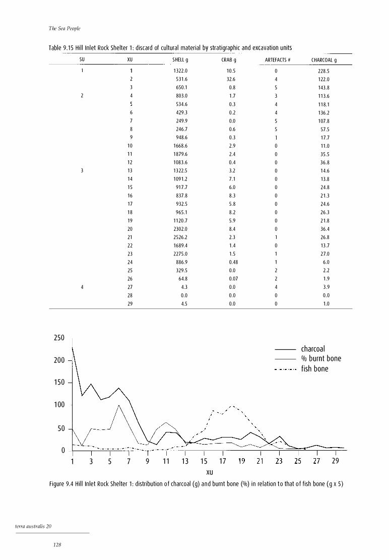
The Sea People
Table 9 . 1 5 H i l l I n l et Rock She lter 1 : d iscard of cu ltura l materia l by strat igraph ic and excavation units
SU XU S HELL g CRAB g ARTEFACTS #
1 322 .0 1 0 . 5 0
2 53 1 .6 32.6 4
3 650.1 0.8 5
2 4 803.0 1 .7 3
534.6 0.3 4
6 429.3 0 .2 4
7 249.9 0.0 5
8 246.7 0.6 5
9 948.6 0 .3
1 0 1 668.6 2.9 0
1 1 1 879.6 2.4 0
1 2 1 083 .6 0 .4 0
3 1 3 1 3 22.5 3.2 0
1 4 1 09 1 .2 7 . 1 0
1 5 91 7.7 6.0 0
1 6 837.8 8 .3 0
1 7 932.5 5 .8 0
1 8 965.1 8 .2 0
1 9 1 1 20 .7 5.9 0
20 2302.0 8.4 0
21 2526.2 2 .3
22 1 689.4 1 .4 0
23 2275 .0 1 . 5 1
24 886.9 0.48 1
25 329.5 0.0 2
26 64.8 0.07 2
4 27 4.3 0.0 4
28 0 .0 0 .0 0
29 4.5 0.0 0
250
200
1 5 0
1 00
5 0
· - · - · - · .... ' ' · - · - · - · - · - · - · ... 0 · - · - . .- · '
I I I I I I I 1 3 5 7 9 1 1 1 3 1 5 1 7
XU
CHARCOAL g
228 .5
1 22 .0
1 43 .8
1 1 3 .6
1 1 8. 1
1 36 .2
1 07.8
57.5
1 7. 7
1 1 .0
35 .5
36 .8
1 4.6
1 3 .8
24.8
2 1 . 3
24.6
26 .3
2 1 .8
36 .4
26.8
1 3 .7
2 7.0
6.0
2 .2
1 .9
3 .9
0 .0
1 .0
charcoa l % bu rnt bone f ish bone
I 2 9
F igure 9.4 H i l l In let Rock She l ter 1 : d istri but ion o f charcoal (g) a n d burnt bone (%) i n re lat ion t o that o f f ish bone ( g x 5 )
terra australis 20
1 28

Hill Inlet, Whitsunday Island
so
45
40 E E
3 5
30
2 5
20 I I I I I I 0 5 1 0 1 5 20 2 5 30
X U
F igure 9.5 H i l l I n l et Rock She l ter 1 : average s i ze of Saccostrea cucullata she l l by excavat ion leve l
ecosystem, including the presence of macrophytic communities, was in place from the beginning of occupation ea. 2800 years ago. The absence of significant quantities of large shellfish, such as Geloina coaxans, shows that they were either not numerous in the inlet or that people had selective preferences for other species . There is evidence for the targeting of densely packed and easily obtainable local rock-platform species such as Nerita undata over species which, although offering more in terms of individual meat weights, may have been much harder to obtain. Overall, the procurement patterns for shellfish point to their relative insignificance in the overall picture.
Crabs were a constant, albeit not always numerically significant resource . Of the three species present, Scylla serrata is the most common, as well as the largest. The appearance of crabs at the very beginning of the cultural sequence, in XU26 of SU3, again indicates the presence of mangrove I estuarine conditions at the time of initial occupation.
Although not very numerous in terms of MNI, fish are well represented in terms of bone weights. All the diagnostic components on which minimum numbers were calculated were in SU3, which contains more than 88% of the total fish bone. Fish bone is highly susceptible to natural attrition and burning in archaeological sites and there appears little question that the decrease in the presence of fish bone after XUlO (SU2) coincides with the significant increase in the intensity or frequency of burning.
Turtle and possibly dugong or one of the small toothed whales are represented in XUl (SUl ) and XU14 (SU3) respectively by single small fragments of bone. Because of taphonomic processes and specific behaviours respecting these heavy-bodied animals, as discussed in Chapter 3, their mere presence in Hill Inlet Rock Shelter 1 is significant in terms of meat returns. A single dugong could provide 300kg of meat and a single green turtle 60kg. Meat from shellfish in Square H15 totals nearly l Okg (9913 .Sg), which, extrapolated over the 30m3 of cultural deposit, gives 11 89 .6kg in the entire site, or approximately 429g of shellfish weight per year. If marine mammals contributed, with plant foods, to the resource base of the Hill Inlet site to a degree not reflected in their archaeological presence, this could explain the situation in SU2 of the site, where intensive occupation evidenced by abundant ash and burning goes hand in hand with a decrease in bone and shell of species used for food. This explanation would be additional, or alternative, to the hypothesis previously discussed, that bone and shell were destroyed in circumstances where increased occupation led to intensified use of fire.
terra australis 20
129
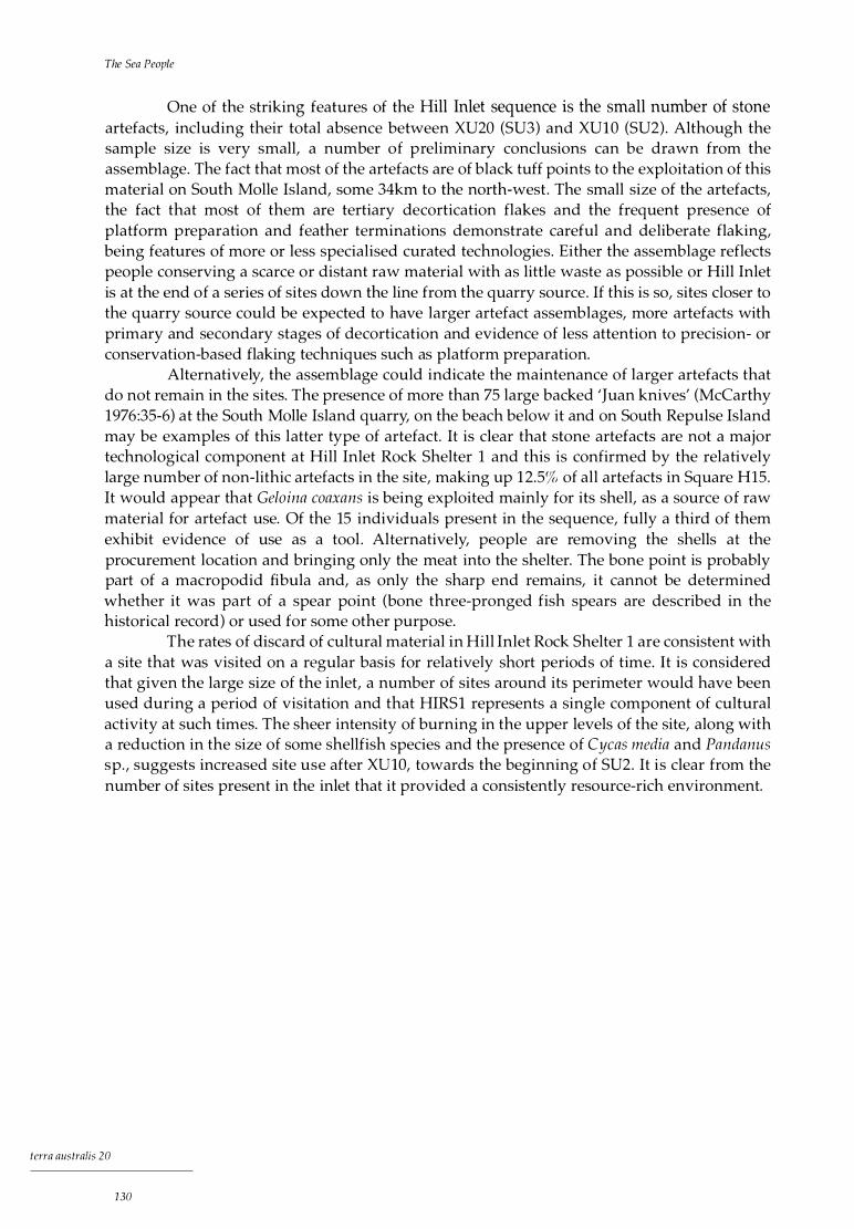
The Sea People
One of the striking features of the Hill Inlet sequence is the small number of stone artefacts, including their total absence between XU20 (SU3) and XUlO (SU2) . Although the sample size is very small, a number of preliminary conclusions can be drawn from the assemblage. The fact that most of the artefacts are of black tuff points to the exploitation of this material on South Molle Island, some 34km to the north-west. The small size of the artefacts, the fact that most of them are tertiary decortication flakes and the frequent presence of platform preparation and feather terminations demonstrate careful and deliberate flaking, being features of more or less specialised curated technologies. Either the assemblage reflects people conserving a scarce or distant raw material with as little waste as possible or Hill Inlet is at the end of a series of sites down the line from the quarry source. If this is so, sites closer to the quarry source could be expected to have larger artefact assemblages, more artefacts with primary and secondary stages of decortication and evidence of less attention to precision- or conservation-based flaking techniques such as platform preparation.
Alternatively, the assemblage could indicate the maintenance of larger artefacts that do not remain in the sites. The presence of more than 75 large backed 'Juan knives' (McCarthy 1976:35-6) at the South Molle Island quarry, on the beach below it and on South Repulse Island may be examples of this latter type of artefact. It is clear that stone artefacts are not a major technological component at Hill Inlet Rock Shelter 1 and this is confirmed by the relatively large number of non-lithic artefacts in the site, making up 1 2.5% of all artefacts in Square H15. It would appear that Geloina coaxans is being exploited mainly for its shell, as a source of raw material for artefact use. Of the 15 individuals present in the sequence, fully a third of them exhibit evidence of use as a tool . Alternatively, people are removing the shells at the procurement location and bringing only the meat into the shelter. The bone point is probably part of a macropodid fibula and, as only the sharp end remains, it cannot be determined whether it was part of a spear point (bone three-pronged fish spears are described in the historical record) or used for some other purpose.
The rates of discard of cultural material in Hill Inlet Rock Shelter 1 are consistent with a site that was visited on a regular basis for relatively short periods of time. It is considered that given the large size of the inlet, a number of sites around its perimeter would have been used during a period of visitation and that HIRSl represents a single component of cultural activity at such times. The sheer intensity of burning in the upper levels of the site, along with a reduction in the size of some shellfish species and the presence of Cycas media and Pandanus sp., suggests increased site use after XUlO, towards the beginning of SU2. It is clear from the number of sites present in the inlet that it provided a consistently resource-rich environment.
terra australis 20
1 30
The South Molle Island Quarry
S i te Descr i pt i on
South Molle Island is a small offshore island o f 420.5 hectares (Plate 10 . 1 ), located 2.6km from the mainland. The quarry (SMIQ) is located on the north-eastern side of the island, on top of a prominent ridge just above Bauer Bay, the main resort beach (Fig. 10 . 1 ). Quarried raw materials and flakes cover an area extending about 300m along the steep ridge, with flakes and other artefacts scattered down the eastern side for more than 200m (Plate 10.2b) and down the western side for about 500m. Stone artefacts have accumulated to a depth of l m in places near the centre of the quarry. Three circular mined pits line the top of the ridge (Plate 10 .2a).
The quarry debris is dominated by extremely large flakes which have been removed from the substrate and used as cores (technologically, they are retouched flakes). A number of water-rolled cobble hammerstones from the beach are also present at the quarry site (Plate 10.2c). The actual substrate from which the raw material has been struck is almost completely covered by huge densities of discarded flaked stone artefacts (Plate 10.2d). More than 75 large backed asymmetrical blades (Juan knives, see McCarthy 1 976:35-6) were collected from the quarry site and the beach below the quarry, with two from South Repulse Island. The archaeological excavation of in situ black tuff artefacts from basal strata going back to 9000 BP at Nara Inlet 1 on Hook Island, some 18km east of South Molle Island, not only demonstrates the early use of this raw material (Chapter 6) but is supporting evidence for a long history of systematic exploitation of the South Molle source (Barker 1988, 1991a, 1993).
Analysis of excavations at a rock shelter (SMil ) directly below the quarry and on the slopes adjacent to the quarry itself may shed further light on the quarry's antiquity (Fig. 10. 1 ).
The South Molle Island quarry appears at first sight to represent large-scale and intensive activity, but this view must be tempered with the knowledge that it has probably been used for more than 9000 years. Recent estimates put the total number of artefacts at the quarry at approximately seven million (Border 1993), which represents a discard rate of about two per day or 777.7 per year over 9000 years. From the results of the excavations reported in this volume ( cf. Barker 1989a, 1991a), the discard rates of artefacts from the South Molle source peaked between about 9000 BP and 3000 BP, during the early stages of the Holocene island
tcrra australis 20
13 1

The Sea People
P late 1 0. 1 View of quarry r idge in Bauer Bay on the northern s ide of South Mo l le I s land .
P late 1 0 .2 South Mol le Is la nd qua rry: (a) mined pit; (b) eastern s lope of quarry; (c) flakes and hammerstones; ( d) tuft substrate.
terra australis 20
132

Rock Shelter SM I 1 •'
�
-- <3-
4m2
f7
South Molle Island
8m2 •
I I I I I /' I
,/ I I J I I I I I I I I I I I
\, I \ I
\ I '........_ __ /
0 =======1=00 m (approximate)
walked transects
...____-- approximate l imits of artefact scatter
c.
4m2 • approximate artefact density
0 quarried pits
F igure 1 0 .1 South Mol le I s l and qua rry (adapted from Border 1 993)
The Sou th Molle Island Quarry
N
I
walking track
�9 bush
terra australis 20
133

The Sea People
system (Table 10 . 1 ) . After this period discard rates decreased, at Nara Inlet 1 by about a third and at Border Island 1 to less than one-eighth.
H istor i ca l Accounts of Abori g i na l Activ i ty on South Mo l l e
The most authoritative reference to the South Molle Island quarry is Roth, who mentions the site in the context of sources of stone for 'stone celts' (edge-ground axes) .
Quarries whence these celts were originally obtained are none too common. There is one on . . .
Molle Island [the old name for South Molle Island] in the Whitsunday Passage and at Culture
Creek, or Happy Valley, about 7 miles from Proserpine (Roth 1904:v7:19) .
Tab le 1 0 . 1 Discard of artefacts of South Mo l le I s land stone at Na ra In let 1 and Border I s land 1 PHASE 1 8990-1 990 BP# /1 OOOYRS
��������
NI 1 79.6
PHASE 1 6900-3080 BP#/1 000YRS
BI 1 ···' 1 0 1 . 2
PHASE 2 1 990-0 BP#/1 000YRS
52 .9
PHASE 2 3080-0 BP#/1 000YRS
1 2 .3
TOT AL # / 1 OOOYRS
73.7
TOTAL #/1 000YRS
61 .7
·' I n th is tab le B I 1 Phase 1 inc ludes the 'i ntermediate' phase.
Two other direct historical references for the use of the South Molle Island quarry are known. One is from an account in a popular magazine by Henry Lamond (1960), a former owner of the lease on South Molle Island and a regular contributor of stories to newspapers and popular magazines. The other is from W.E . Bauer (1958), the founder of the South Molle Island Resort. Both accounts are relatively recent (1930s-1950s) and may be apocryphal.
Lamond's source was an old Aboriginal man named Percy, who told him that local Aboriginal people used to obtain stone for axes from South Molle Island.
They went to what we call South Molle for stone with which to make tomahawks. They called
that island 'Whyrriba' which meant stone axe. I should know. It was my home for exactly ten
years (Lamond 1960:2).
Bauer 's account is similar.
The native name for South Molle was 'Werribee' which translated means stone flints. We have a
range on the Island where this flint is very plentiful, and the natives used to make their stone
axes here (Bauer 1958).
The archaeological evidence does not support the idea that the quarry was used for axe manufacture. Extensive surveys of axes from the mainland, including private collections, collections with local historical societies and those at the Queensland Museum, have not led to the identification of a single axe manufactured from anything resembling the South Molle Island raw material. Generally, axes are made from rocks with a high degree of plasticity, unlike the South Molle tuff, which is highly siliceous and brittle, with excellent flaking characteristics. Additionally, no axe, blank or artefact resembling a stage of axe manufacture has ever been found on or near the quarry. It may be that when stating that the quarry was used for the manufacture of stone 'celts', Roth (1904:v7:19) was referring to the large backed 'Juan knives' found at the quarry and on the beach below it, which appear to have followed a precise and systematic process of reduction (Fig. 10.2), although his description of stone 'celts' as edge-ground axes seems unambiguous. Another possibility is that another source of black tuff exists from which axes were manufactured and that it is this source which Roth (1904:v7: 19) mistakenly refers to as the Molle Island quarry. This is, however, unlikely, given the acknowledged accuracy of Roth's ethnographic work and the lack of any evidence that stone axes were made from black tuff.
terra australis 20
1 34

Othe r Raw Materi a l s Sou rces
Although relatively extensive geological surveys have been carried out in the Whitsundays and on the adjacent mainland (Bryan 1991; Ewart et al. 1992; Paine 1972; Parianos 1992), there is only one other known source of raw material - at Kuttabul on the mainland coast - resembling that from South Molle Island . This does not rule out the possibility that other sources may occur on the islands, as the formation of the raw material is described as a 'pyroclastic surge deposit', which will usually occupy a relatively discrete area (Bryan 1991 :56 ). However, the requisite geological conditions involve a combination of factors unlikely to be commonly duplicated (Bryan 1991 :56).
There are other raw material sources known in the region (Fig. 10.3 ). These are as follows. 1 ) The material mentioned above that looks similar to
that of the South Molle Island source was seen at a commercial quarry used by the Pioneer Shire Council near Kuttabul, north of Mackay, 12km inland and 90km south of South Molle Island. Unlike the South Molle Island source, however, there is no evidence that this was ever utilised during prehistoric times. It does, however, confirm the presence of a similar raw material type in the region.
The South Molle Island Quarry
2 CM
F igure 1 0.2 Juan kn i fe (drawn by Bruno David)
2) A quarry source at Happy Valley on Culture Creek (possibly Kelsey Creek), llkm west of Proserpine, is known from the literature (Roth 1904:v7: 19), but has yet to be
3)
4)
rediscovered and characterised. Artefacts from around the Proserpine region are, however, commonly made of stone that is petrographically different from that found on South Molle Island, making it unlikely that the raw material from the Happy Valley source is black tuff. Another raw material source is to be found at Blue Bay on Cape Hillsborough, where beach shingle has been quarried for artefactual material over an extensive area at the eastern end of the headland separating Blue Bay from Halliday Bay. This raw material is a blue-grey volcanic rock, petrographically dissimilar to the South Molle material. A green volcanic material is found on South Repulse Island. Artefacts from this source have been found on South Repulse Island and Cape Conway. In addition to these sources, the volcanic nature of the region suggests that there
should be no shortage of sources of brittle siliceous stone, a raw material category ideal for stone artefact manufacture.
D istr i but ion of B l ack Tuff
Most of the sites with black tuff artefacts are found in the islands (Table 10 .2, Fig. 10 .3) . The mainland coast between Bowen and southern Cape Conway (Area A) includes a relatively high percentage of such sites, but also sites with a range of other local raw material types. The area west of Airlie Beach, including the Proserpine region (Proserpine Hinterland ), has little material resembling black tuff and the sites have artefacts made from other materials. The
terra australis 20
135
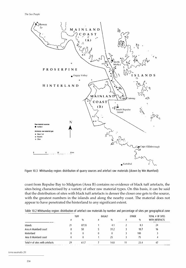
The Sea People
Bowen lb M A I N L A N D
0
+
P R O S E R P I N E
C O A S T <l
( A ) A
• Happy Valley
H I N T E R L A N D
Raw material sources • Kuttabul
Artefacts: raw material type * Black Tuff •!• Basaltic + Other
N
t 10 20 30 km ====:-=---=---=---±=--=--==========-=-=-?
+
� +*� •!- South Repulse
Island
• Kuttabul
L A N D S ()
F igure 1 0 .3 Wh itsun day region : d istri but ion of quarry sources and artefact raw mater ia l s (drawn by Win Mumford)
coast from Repulse Bay to Midgeton (Area B) contains no evidence of black tuff artefacts, the sites being characterised by a variety of other raw material types. On this basis, it can be said that the distribution of sites with black tuff artefacts is denser the closer one gets to the source, with the greatest numbers in the islands and along the nearby coast. The material does not appear to have penetrated the hinterland to any significant extent.
Tab le 1 0.2 Whitsunday reg ion : d istri but ion of a rtefact raw mater ia ls by number and percentage of sites per geographica l zone
TUFF BASALT OTH ER TOTAL # OF SITES # % # % # % WITH ARTEFACTS
Is lands 21 87.55 1 4 . 1 2 8.3 24
Area A Mainland coast 8 50 5 3 1 .2 3 1 8.7 1 6 Hi nterland 0 0 0 0 3 1 00 3
Area B Main land coast 0 0 25 3 75 4
Total # of sites with a rtefa cts 29 6 1 .7 7 1 4 .8 1 1 23 .4 47
tara australis 20
136

The Sou th Molle Island Quarry
Petrog ra ph i c Ana lys is
A petrographical classification of various black tuff artefacts from the region was undertaken to determine whether or not the stone artefacts found in archaeological sites on the islands and adjacent mainland indeed came from the black tuff quarry source on South Molle Island (Barker and Schon 1994). The aims were to achieve a preliminary geological characterisation of the quarry material and to establish the lithic types found in the artefacts of the region. To this end 11 samples were chosen for thin-sectioning (Table 10 .3). The artefacts were selected on the basis of representativeness of raw material variation at the quarry itself (SM 1-5) and the distribution of artefact material closely resembling the South Molle raw material type from around the region.
All materials examined were extremely fine-grained and classification was therefore made on the basis of alteration of phenocryst assemblages . Two main groups were identified, distinguished here as SM and SR types (Barker and Schon 1994):
SM type: samples SM2 (South Molle quarry), SM4 (South Molle quarry), Wll (Whitsunday Island), probably SMl (South Molle quarry) and possibly SM3 (South Molle quarry). These artefacts are characterised by a fine-grained silicified tuff, black to green-grey in colour, with scattered patches of calcite alteration and quartz I albite . The calcite alteration is characteristic of these implements.
SR type: samples SRI (South Repulse Island), Bll (Border Island) and Hll (Hill Inlet, Whitsunday Island). These artefacts are characterised by a fine and even-grained silicified tuff exhibiting sparse deformed fiamme and bedded opaques.
The following artefacts were unclassified: MPl (Middle Percy Island): a fine-grained, strongly welded silicified ignimbrite with
glass shards measuring up to l mm. ERl (Earlando Bay): a fine-grained, even-textured silicified tuff with sparse quartz veins
and bedded opaques. Except for the quartz veins, this sample could be grouped in the SR type. SMS (South Molle quarry): more fine-grained than the other materials, with scattered
opaques and traversed by quartz veins. These latter distinguish it from the SM type, to which it is otherwise similar.
Table 1 0.3 Wh itsunday reg ion : petrograph ic descr ipt ion of selected a rtefacts TYPE ARTEFACT
SM SM2
SM SM4
SM Wl1
SM SM1
SM SM3
SR SR1
SR B l 1
SR H l 1
UNCLF MP1
UNCLF ER1
UNCLF SMS
LOCATION
SOUTH MOLLE QUARRY
SOUTH MOLLE QUARRY
WHITSUNDAY I
SOUTH MOLLE QUARRY
SOUTH MOLLE QUARRY
REPULSE I
BORDER I
WH ITSUNDAY I
PERCY I
EARLANDO BAY
SOUTH MOLLE QUARRY
DESCRIPTION
Artefacts a re characterised by a f ine-gra ined si l i c if ied tuft, black to green-grey in colour, with scattered patches of calcite alterat ion and quartz/a lbite. The calcite a l teration i s characteristic of these imp lements.
Artefacts are characterised by a f ine and even-gra ined s i l ic if ied tuft with sparse deformed f iamme and bedded opaques.
Fine-grai ned, strongly welded si l i cif ied ignimbrite with glass shards measuring up to 1 mm.
F ine-grained, even-textured si l i c if ied tuft with sparse quartz veins and bedded opaques.
More fine-grained than the other materia ls, with scattered opaques and traversed by quartz veins. These latter dist inguish it from the SM type, to which it is otherwise s imi lar.
137
terra australis 20
The Sea People
D i scuss ion
Although the sample size i s small, some conclusions can be drawn from the data. Most o f the material analysed from the quarry (SM2, SM4, SMl and SM3) can be classified as coming from a single source . The distinctive SMS sample suggests that the raw material from the quarry is heterogenous petrographically and that a large sample of quarry material will have to be thinsectioned in order to fully classify it geologically. Most of the remaining samples, SR and unclassified types, are superficially similar in appearance to the South Molle raw material. It may be that further investigation will show these types to be part of that source.
The SRl sample is a backed implement of green tuff similar to a raw material source found on South Repulse Island and thus probably not from the South Molle Island quarry. MPl from Middle Percy Island, 230km south of South Molle Island, is the most dissimilar of the raw materials and is thus unlikely to be from the South Molle source.
Although the initial petrographic results on black tuff are largely inconclusive, the distribution of this broad raw material type in the region shows it to have been used almost exclusively on the islands, from Hayman south to (at least) the Repulse Islands (Fig. 10 .3, Islands), and on the mainland coast from Bowen to Cape Conway (Fig. 10.3, Mainland Coast A). It is possible and, indeed, I would argue likely, that once a large sample of the quarry has been obtained, most of the artefacts found on the Whitsunday Islands and the adjacent mainland coast will be traced to the South Molle Island source. This can be suggested because of the absence of any other source of similar stone in the wider region, except at the Pioneer Shire quarry north of Mackay, which seems not to have been utilised in prehistory.
Conc l us ion
The preliminary results o f this study show that the distribution o f black tuff artefacts is largely restricted to areas within the historical Ngaro system, either on the islands of the northern Cumberlands or the adjacent Cape Conway mainland coast. This is essentially the territory of the Ngaro as defined by Tindale (1974:1 82), suggesting that the quarry on South Molle Island may have been exploited largely for local use throughout its long history. It could be surmised that because of the abundance of suitable raw materials throughout the wider region, circumstances did not favour the black tuff being used as an item of exchange or being carried over great distances. The greatest number of sites with artefacts of black tuff, as well as the highest densities of this artefactual material, are within close proximity to the quarry on South Molle Island. The absence of the raw material on the mainland coast south-west of Cape Conway (Mainland Coast B) and in the coastal hinterland around Proserpine (Proserpine Hinterland) and its presence at Queens Beach, Bowen, more than 70km to the north, chart the nature of the interaction between the island and coastal peoples in the vicinity of the Whitsundays.
terra australis 20
138
The Archaeology: A Synthesis
Tim i ng of Occupat ion
The earliest evidence o f occupation in the Whitsunday Islands dates to before 9000 B P a t Nara Inlet 1 . At this time the site would have been close to the sea but part of the mainland coast. Hook and Whitsunday Islands were the eastern arm of a large peninsula extending as far south as Cape Conway, the headland of which was formed by the northern ends of Hook and Hayman Islands (see Fig. 4.2). The islands of today were rugged mountain tops rising up from broad and relatively extensive plains. Nara Inlet was a river valley, with the western coast of the peninsula some 1 .5km away from the Nara Inlet 1 site. Human occupation of sites such as this prior to the arrival of the coastline was unlikely, or remote, given the settlement options available on the adjacent extensive plains. I would argue that Nara Inlet 1, and perhaps the region as a whole, was a focus of occupation by coastal peoples who were following the coast as sea level rose, utilising shelters as the sea came into close proximity to them (see Bowdler 1977; McNiven 1991 ).
South Molle Island also probably demonstrates use dating back to 9000 BP, as attested by the presence of South Molle artefacts at Nara Inlet 1 . South Molle at this time was on the opposite side of the large inlet, forming part of its eastern coast. Although located to the east of Hook Island and therefore closer to an earlier coastline, Border Island 1 was not occupied until about 7000 BP, when it was probably already an island. This is not surprising given that even today the Border Island 1 rock shelter is some 40m above high-water mark in a near-sheer cliff face and was unlikely to have been an option for habitation before rising sea level enabled easier access.
The two other sites investigated, Hill Inlet Rock Shelter 1 and Nara Inlet Art Site, were occupied only in the late Holocene, at 2770 BP and 2350 BP respectively. When Nara Inlet 1 was initially occupied (by 9000 BP), Hill Inlet 1 was still some lOkm from the coast, well up a long river valley and facing a broad coastal plain. Nara Inlet Art Site, only a few hundred metres from Nara Inlet 1 but at a much higher elevation, was, as has already been stated, less than 2km from the sea.
terra australis 20
1 39
The Sea People
The earliest evidence for occupation of the region thus coincides with the initial arrival of the sea. This comes from the sea-level data and the fact that there is no pre-marine element in any of the archaeological assemblages. It seems likely that people were at this time, as is the case today, largely occupying the low coastal plains and coastal fringe and that the bulk of the evidence for their occupation is now under water. Whether there was a resident population in the region prior to 9000 BP is debatable and the question is unlikely to be resolved until sites on the mainland to the west of the current coastline are investigated . Although i t might be expected that the newly arrived coastal peoples utilised the hinterland from the start, it is interesting to note that the only sites excavated on the mainland from Townsville south to the Whitsunday region all record late-Holocene dates (Table 11 . 1 ) . Although some of these dates are not basal, the sites are all considered to have been first occupied sometime during the late Holocene (Brayshaw 1990:210) . I feel, however, that no clear statement about hinterland use can be made until further research is carried out on the mainland, except to repeat that as sea levels rose, drowning the flat plains to the east of the current coast, it should be expected that greater use was made of the area to the west of it. The fact that only late-Holocene sites have been identified there could be due to the greater archaeological visibility of such sites and I or a product of sample size.
Tab le 1 1 . 1 Occupation dates for h in ter land sites Townsv i l l e to Cape Upstart
LOCATION D ISTANCE TO COAST RADIOCARBON YEARS bp
Kennedy A Mt Creagh 1 8km 685±1 05
jourama Paluma Range 1 5km 1 450±1 1 0
Herveys Range Herveys Range 26km 1 455± 140
Mt Roundback Cape Upstart 8km 1 650± 1 20
None of the sites I investigated in the islands shows any pattern of change coinciding with the mid-Holocene stabilisation of sea level around 7000 years ago. The changes represented by the contrast between Phases 1 and 2 at Nara Inlet 1 and Border Island 1 are late Holocene in date, 3000 BP and later. They are shared by the two sites whose utilisation postdates 3000 BP, Hill Inlet Rock Shelter 1 beginning at 2770 BP and Nara Inlet Art Site beginning at 2350 BP.
Su bs i stence and Economy
Marine resources predominate in all the sites a s yet excavated i n the Whitsunday Islands. Although this should not be surprising given that they are all coastal sites, it is clear that the pattern of occupation and settlement is an accurate reflection of a broader, essentially coastal system, as discussed below.
The relative importance of dietary resources Although the bulk of the cultural material in all the sites is shellfish, these comprised only a small proportion of the overall diet. Fish and turtle were the two most important animal foods throughout. Together they contributed 86.4% of meat weights at Nara Inlet 1, 82.3% at Nara Inlet Art Site, 81 . 1% at Hill Inlet Rock Shelter 1 and 96.7% at Border Island 1 (Table 11 .2) . In contrast, terrestrial fauna never contributed more than 6.3% of total meat weights and shellfish contributed a maximum of only 15 .6% . Overall, fish comprised 46.2% of the total meat in all the sites, turtle comprised 39.2%, shellfish comprised 10.0% and terrestrial fauna comprised a minimum of 4.6% .
terra australis 20
140

The Archaeology: A Synthesis
Table 1 1 .2 The relat ive importance of d ietary resources at the invest igated s ites
N l 1 N IAS 8 1 1 H I RS1
kg % kg % kg % kg %
Shel lfish 1 007.5 7.4 7 1 4.3 1 2 .8 1 1 5 .6 3.3 1 1 89.6 1 5 .6
Fish 7999.2 58.5 392.0 7.0 1 280.0 36.6 4368.0 57.4
Turtle 381 4.8 27.9 4200.0 75.3 2 1 00.0 60 .1 1 800.0 23.7
Terrestrial 858.0 6.3 274.4 4.9 252.0 3 .3
TOTALS 1 3679.5 5580.7 3495.6 7609.6
The very small quantities of bone recovered from the larger marine animals such as turtle suggest a butchering pattern that precludes rock-shelter deposition of skeletal material from these species. For example, the weight of turtle bone and turtle shell for a minimum number of four at Nara Inlet 1 totals a mere 6 .2g. The evidence for dugong exploitation is even more problematic, being a single tentative identification at Hill Inlet 1 . The presence of whale bone has likewise been identified at Nara Inlet 1 from just seven teeth. Clearly, the bulk of the skeletal remains of these large animals is either not being brought into the site or is being removed from the site after consumption. Nonetheless, turtle bone and turtle shell are present in all the sites analysed. At Nara Inlet Art Site and Border Island 1, turtle makes up the majority of the meat weights represented in the faunal assemblage (Table 11 .2) .
Because of the difficulty in assessing MNI and meat weights, a resource that is probably significantly underestimated is the crustaceans, principally the mud crab, Scylla serrata . This species appears in all of the sites except Border Island 1 and is present in considerable quantities in Hill Inlet Rock Shelter 1 . As well, being a mud-dwelling species dependent on macrophytic communities, its presence in the early phase of occupation at Nara Inlet 1 clearly establishes the presence of tropical mangrove communities in the region throughout the Holocene, including the period of sea-level rise in the early Holocene.
Although the terrestrial component of the subsistence base is small in all of the sites analysed, there is nonetheless a relatively extensive fauna! suite, with at least 13 individual species present. This demonstrates that a fairly large and diverse terrestrial component was available, including relatively big mammals such as the macropod, Petrogale inornata, and the possum, Trichosurus vulpecula .
Plant remains, well represented in all the sites except Border Island 1, are considered to have been an important component of the diet. The species present are all tropical and there is an increase in their number over time, with the poisonous Cycas media and Bruguiera gymnorh iza, which require intensive processing before consumption, appearing only after 524 BP in Nara Inlet 1 and in the upper XU of Nara Inlet Art Site and Hill Inlet Rock Shelter 1 . This would appear to result not from differential preservation, since plant material was present throughout the sites and especially at Nara Inlet 1, with sticks, grass, leaves, bark (including paperbark) and seeds being retrieved from the lowest XU.
Plant remains also provide some evidence for seasonality of site use in the form of the three summer (wet season) fruiting species: the Burdekin plum (Pleiogynium timorense), the cocky apple (Planchon ia careya) and the screw palm (Pandanus spiralis ), all of which have ripe fruit between September and October. These three species are represented in a number of sites by their fruit seeds. Similarly, plant remains that are described in the ethnohistorical and ethnographic records as being highly toxic, laborious to prepare and very much a secondary food, such as the hypocotyl of the orange mangrove Bruguiera gymnorhiza, may also point to summer occupation. Thus Moore (1979:275) has said of Torres Strait that:
tcrra australis 20
141

The Sea People
[t]he food situation during the months of the northwest monsoon . . . was much less favourable. The main support during the wet season was a grey paste made from the pith of sprouts of a
particular type of edible mangrove known as biyu . This has been tentatively identified by
Harris (1976: 104-5) as Bruguiera gymnorhiza.
The differences in the faunal assemblages of the four excavated sites can be explained largely by differences in local environments. For example, Hill Inlet is a large, shallow and heavily mangroved inlet with large sandy patches and few rock platforms or fringing reefs . Appropriately, there is a predominance of bivalves over gastropods, significant numbers of the mud-dwelling crustacean, Scylla serrata, and sandy-bottom fish such as the northern whiting (Sil/ago s ihama) and yellow sweetlip (Lethrinus nebulosus) . In contrast, Nara Inlet 1 is depauperate in mangroves, has an extensive rock-platform shoreline and a large fringing reef. Consequently, rock-platform gastropods and fringing-reef fish species predominate in the archaeological sites. This picture is repeated at Border Island, a small, relatively isolated island with few mangroves, no known large terrestrial fauna and a large fringing reef. The excavations at Border Island 1 revealed no terrestrial component in the subsistence base and a prominence of turtle.
Another factor which may account for the differences in subsistence items in the various assemblages is the intensity and duration of occupation of the various islands and sites. Thus Border Island 1 contains a much reduced range of fauna, as well as relatively low discard rates of cultural materials. Unlike the other sites, plant remains are absent, perhaps suggesting sporadic visitation of short duration in which a broad range of subsistence activities like those apparent at Nara Inlet 1 were not carried out. In this context, differences are also apparent between the two contemporaneous assemblages at Nara Inlet 1 and Nara Inlet Art Site, separated by just 400m of water. In particular, the macropod, Petrogale inornata, is consi derably more important at the art site than at Nara Inlet 1 . This introduces an archaeological problem of scale and sampling: when are two components to be considered distinctive or unrelated, given that any given system will be made up of different yet articulating components? This issue becomes even more evident at Nara Inlet when we consider that the Nara Inlet Art Site has an extensive body of rock art and a reported stone arrangement in front of it, whereas Nara Inlet 1 has no art and no evidence of ceremonial activity.
The shellfish assemblages are dominated by small gastropod species such as Nerita undata and Lunella cinerea, which provide very little in terms of meat. The single most important shellfish in terms of meat is the chiton, Acan tlwpleura gemmata, which is dominant in all sites except Hill Inlet 1. This is probably due to the fact that the latter is situated in a sandy I muddy estuarine system in which chi tons are rare.
Although it is clear that large mud-dwelling bivalves such as Gelonia coaxans were available, it appears that little effort was expended in obtaining them. Selectivity in species procurement tends to show that those species which were most easily obtained, requiring little extractive effort or travel, were favoured over those whose procurement was less accessible and more labour-intensive, even if they were of considerable size. At Nara Inlet 1, muddwelling bivalves such as G. coaxans, Pinctada fucata and Asaphis deflorata occur only in Phase 2. This may indicate a minor increase in local sedimentation and an expansion of macrophytic communities in Nara Inlet or nearby after this time or reflect changes in procurement choice relating to shellfish.
terra australis 20
1 42
The Archaeology: A Synthesis
Changes in subsistence Changes in the subsistence base are reflected mainly in increased densities of previously exploited species over time (Figs 6 .5, 6 .6, 6 .8-19 at Nara Inlet 1 ) and the broadening of the resource base in Phase 2, with the addition of a small number of new species (see the mention of Geloina, Pinctada and Asaphis in the previous paragraph). Human-induced modifications to the resource base include change in the available age structure (and thus size) of some shellfish species, in particular a reduction in the sizes of Saccos trea cucullata at Hill Inlet 1 (Fig. 9.5) and of Nerita undata at Nara Inlet 1 (Fig. 6 .7).
One of the features of the subsistence base at Nara Inlet 1 and Border Island 1 is that the species exploited from the time of initial occupation are extant today and were continuously exploited throughout the Holocene. There is evidence from the presence of tropical species of fish, crustaceans and shellfish in the Nara Inlet 1 assemblage from 9000 BP to suggest that the broad climatic pattern of today was largely in place by the time of initial occupation in the early Holocene. It is also clear that macrophytic communities were in place throughout the period of occupation, suggesting that the species that appear only in the archaeological record in Phase 2 were nonetheless available well before that time. I would argue that their exploitation (albeit limited) in Phase 2 reflects procurement choice rather than gross availability.
Conclusion Although it can be said that a wide variety of marine and terrestrial foods made up the subsistence base of the Whitsunday Islanders, it is clear that the major subsistence items were marine in origin, including plant species such as the orange mangrove, Bruguiera gynznorhiza. The Ngaro and their ancestors can thus be characterised as operating a marine economy.
Sett lement Pa tte rn
One of the obvious difficulties in discussing a settlement pattern for the Whitsunday region is the lack of previous research in the region, specifically on the mainland hinterland directly to the west of the northern Cumberland Islands. Of the 61 sites known for the region, 56 are either on the islands or on the adjacent mainland coast, the areas extensively surveyed during the course of this research. The area west of the coastal range has had considerably less attention and remains largely unknown archaeologically (but see Brayshaw 1990). This said, there are a number of archaeological factors, as well as strong ethnohistorical evidence, indicating that, at least in the late Holocene, the Whitsunday system was restricted largely to the islands and the coast, failing to extend significantly into the mainland interior (see Chapter 12) .
The strongest archaeological indicator of the position of the hinterland in the broader picture comes from the distribution of the stone artefacts likely to be made from the material of the South Molle Island quarry (Barker and Schon 1994). As shown in Figure 10 .3, their distribution extends south down the mainland coast from Bowen to Cape Conway and includes 12 islands from Hayman Island as far south as the Repulse Islands. They are not found, however, in sites on the mainland to the west and south of Cape Conway nor on the western side of the coastal range in the Proserpine region. As discussed elsewhere (Chapter 10), this pattern of distribution closely resembles the ethnohistorically described boundaries for the island peoples of the northern Cumberlands and thus may be a late-Holocene phenomenon.
terra australis 20
1 43
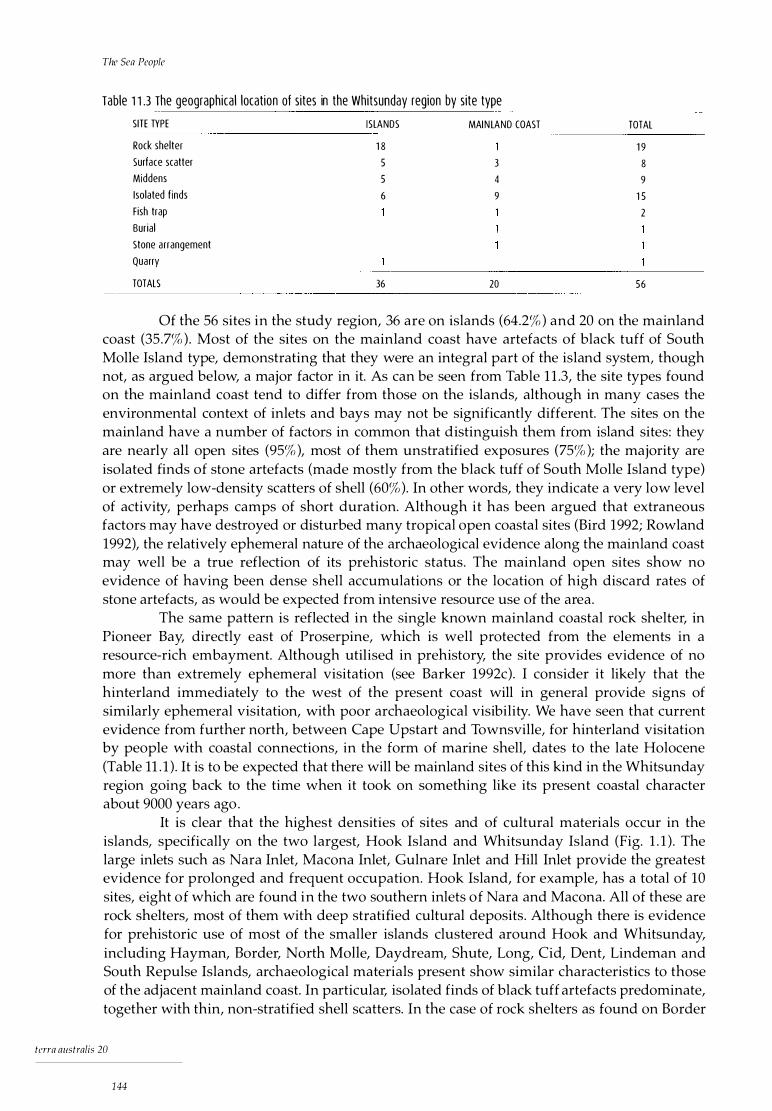
The Sea People
Table 1 1 .3 The geographical location of sites in the Whitsunday region by site type
SITE TYPE I SLANDS MAIN LAND COAST TOTAL
Rock shelter 1 8 1 9 Surf ace scatter 5 3 8 Middens 5 4 9 Isolated f inds 6 9 1 5 Fish trap 2 Burial
Stone arrangement
Quarry
TOTALS 36 20 56
Of the 56 sites in the study region, 36 are on islands (64.2% ) and 20 on the mainland coast (35 .7% ) . Most of the sites on the mainland coast have artefacts of black tuff of South Molle Island type, demonstrating that they were an integral part of the island system, though not, as argued below, a major factor in it. As can be seen from Table 1 1 .3, the site types found on the mainland coast tend to differ from those on the islands, although in many cases the environmental context of inlets and bays may not be significantly different. The sites on the mainland have a number of factors in common that distinguish them from island sites: they are nearly all open sites (95% ), most of them unstratified exposures (75% ); the majority are isolated finds of stone artefacts (made mostly from the black tuff of South Molle Island type) or extremely low-density scatters of shell (60% ). In other words, they indicate a very low level of activity, perhaps camps of short duration. Although it has been argued that extraneous factors may have destroyed or disturbed many tropical open coastal sites (Bird 1992; Rowland 1992), the relatively ephemeral nature of the archaeological evidence along the mainland coast may well be a true reflection of its prehistoric status. The mainland open sites show no evidence of having been dense shell accumulations or the location of high discard rates of stone artefacts, as would be expected from intensive resource use of the area.
The same pattern is reflected in the single known mainland coastal rock shelter, in Pioneer Bay, directly east of Proserpine, which is well protected from the elements in a resource-rich embayment. Although utilised in prehistory, the site provides evidence of no more than extremely ephemeral visitation (see Barker 1992c). I consider it likely that the hinterland immediately to the west of the present coast will in general provide signs of similarly ephemeral visitation, with poor archaeological visibility. We have seen that current evidence from further north, between Cape Upstart and Townsville, for hinterland visitation by people with coastal connections, in the form of marine shell, dates to the late Holocene (Table 11 . 1 ) . It is to be expected that there will be mainland sites of this kind in the Whitsunday region going back to the time when it took on something like its present coastal character about 9000 years ago .
It is clear that the highest densities of sites and of cultural materials occur in the islands, specifically on the two largest, Hook Island and Whitsunday Island (Fig. 1 . 1 ) . The large inlets such as Nara Inlet, Macona Inlet, Gulnare Inlet and Hill Inlet provide the greatest evidence for prolonged and frequent occupation. Hook Island, for example, has a total of 10 sites, eight of which are found in the two southern inlets of Nara and Macona. All of these are rock shelters, most of them with deep stratified cultural deposits. Although there is evidence for prehistoric use of most of the smaller islands clustered around Hook and Whitsunday, including Hayman, Border, North Molle, Daydream, Shute, Long, Cid, Dent, Lindeman and South Repulse Islands, archaeological materials present show similar characteristics to those of the adjacent mainland coast. In particular, isolated finds of black tuff artefacts predominate, together with thin, non-stratified shell scatters. In the case of rock shelters as found on Border
terra australis 20
144

The Archaeology: A Synthesis
Island, there is evidence of infrequent or small-scale, short-term use. It could be said, then, that by the late Holocene the islands of Hook and Whitsunday formed the core areas of occupation for the island inhabitants, with South Molle Island lik�ly to have held a special position in the social landscape as a specialised source of raw material. South Molle Island is the only small island with any evidence of prolonged and intensive prehistoric activity in the region.
As stated previously (Chapter 5, the section on the survey strategy), the higher the number of resource zones found in any one area, the greater the likelihood of prehistoric human exploitation. The high proportion of sites found in inlets and bays may be due to the fact that they provide shelter and protection from the elements, as well as a wide variety of different resources in an extremely rich ecosystem. This may have been important for a marine-based people whose mobility was often affected by such potentially random factors as adverse weather conditions. It is in these environments that people could base themselves for fairly long periods of time, moving out to other, less resource-rich zones when conditions permitted.
Techno logy
Technologically, all o f the archaeological sequences are dominated by stone artefact assemblages, more than 80% of which are black tuff of South Molle Island type. There is a similar pattern of discard in the four excavated shelter sites, with a significant decrease in discard rates after 3000 BP in the two sites occupied from before that date, Nara Inlet 1 (Fig. 6.20) and Border Island 1 (Fig. 8 . 11 ), and a comparably low rate of discard in the two sites occupied after it, Nara Inlet Art Site (Table 7. 11 ) and Hill Inlet Rock Shelter 1 (Table 9 .15) . Preliminary technological investigations of the stone assemblages indicate a similar pattern in the four sites : a lack of formal types, a lack of cores, small average size, a high proportion of tertiary decortication and a high proportion of flakes with feather terminations. Apart from the decreases in discard rates, no technological differences between the pre-3000 BP (Phase 1 ) and post-3000 B P (Phase 2) assemblages have been established, due perhaps to small sample sizes in the later phase. What is now needed is a technological analysis of the relatively large post-3000 BP Nara Inlet Art Site assemblage and research at the quarry itself.
Although my own technological analyses were limited and must be considered as preliminary in nature, it would be reasonable to state that the stone assemblages from the stratified sites indicate a largely curative technology. In contrast, the artefacts at the South Molle Island quarry and the beach immediately below include a huge number of very large flakes, cores and hammerstones, with some formal artefact types in the form of large asymmetrical backed blades (Juan knives) . It would appear that initial and later stages of artefact manufacture took place at the quarry itself or on the beach below rather than elsewhere. This is supported by the sheer quantity of artefactual material on South Molle Island relative to that found in the stratified sites on the other islands.
Another important aspect of the technology as reflected in the archaeological sites is the relatively large number of non-lithic artefacts found in post-3000 BP contexts. This constitutes an important change and it coincides with a decrease in stone artefact discard rates: at Nara Inlet 1 all 1 3 non-lithic artefacts are from the two upper SU that constitute Phase 2 ( cf. Table 6 . 14) and described as being used for marine procurement. They include a possible net, a wooden harpoon barb, a relatively large number of bone points (7) and 15 shell and turtle shell artefacts. Although no fish-hooks were found, the two square pieces of cut turtleshell and the shell 'blank' from Nara Inlet 1, together with the coral 'file' from Border Island 1, are suggestive of their presence.
terra australis 20
1 45
The Sea People
In the Whitsunday Islands there is clear evidence that watercraft of some type were being used from at least 7500 BP and probably for a considerable time before. Stone artefacts of black tuff reasonably attributed to the South Molle Island quarry are found continuously throughout Nara Inlet 1 and Border Island 1 from the time of initial occupation before 9000 BP and around 7000 BP respectively. At 9000 BP, the quarry was on a low ridge forming part of a large hill on a coastal plain. By at least 7500 BP, this hill had become an island separated from the mainland, Nara Inlet and Border Island by 4km, 15km and 30km of open sea respectively. Despite this, the stone thought to be from the South Molle source continued to be used without apparent interruption, clearly demonstrating the use of watercraft.
Overall, the continuous use of the coast and offshore islands for 9000 years by people in the Whitsunday region provides clear evidence that coastal and island occupation did not necessarily have to await specialised technology. I argue that such specialised marine technology as harpoons, outrigger canoes and fish-hooks is present only after 3000 BP, some 4000-5000 years after the islands were formed, or perhaps even later, after 520 BP.
Co nc l us ion
The archaeological data have established a number of important trends relating to the aims of this research. These can be summarised as follows: 1 ) that marine resources were more or less continuously available throughout the
Holocene and, in a general sense, were largely unaffected by documented environmental changes such as the post-glacial marine transgression;
2) that people lived continuously on the coast throughout the Holocene (and, by inference, the Pleistocene as well), moving with the changing coastline;
3) that changes in settlement, subsistence and technology occurred after ea. 3000 BP, as discussed in previous sections of the chapter and seen in particular over the long sequence of occupation at Nara Inlet 1 . These include:
terra australis 20
1 46
a) a decrease in discard of stone artefacts; b) the corresponding appearance of a range of non-lithic artefacts technologically
linked to marine resource procurement and I or made from marine products; c) significant increases in rates of discard of cultural materials except for stone
artefacts but including shell, bone and charcoal; d) the appearance of some new marine resources, in the form of three shellfish
species (Gelonia coaxans, Pi11ctada fucata and Asaphis deflorata) at Nara Inlet 1 ; e) the establishment o f new sites, in the islands (Nara Inlet Art Site and Hill Inlet
Rock Shelter 1 ) and on the mainland (Table 1 1 . 1 ); f) evidence of predation pressure on some shellfish species, Nerita undata (at Nara
Inlet 1) and Saccos trea cuculla ta (at Hill Inlet Rock Shelter 1 ); and g) the introduction of labour-intensive preparation of poisonous plants as food ( Cycas
media and Bruguiera gymnorhiza) after 520 BP.

Towards a Prehistory of the Whitsunday Is l ands
Ho locene Cha nge and the Wh itsunday I s l ande rs
The archaeological evidence from the Whitsundays has some unique advantages over work carried out previously on the tropical east coast of Australia, in that it provides relatively long temporal sequences spanning the period of the last post-glacial marine transgression. It has thus provided an unparalleled opportunity to examine the relationship between human coastal occupation and environmental change throughout the Holocene. In this chapter, I draw together some of the main points regarding this relationship and present a general explanatory model of Whitsunday prehistory.
Archaeological patterns of change It would appear that a generalised coastal hunter-gatherer population first inhabited the region at ea. 9000 BP. At that time, to generalise from Nara Inlet 1, the occupation of sites was brief and ephemeral, with exploitation of a restricted range of largely terrestrially based marine resources, such as rock-platform shellfish and fringing-reef fish, and a greater emphasis on terrestrially based animals such as small macropods. The number of sites occupied on the coast and islands would have been relatively low. This picture, I argue, is indicative of reasonably small and mobile groups whose settlement and subsistence patterns reflect 'classic' models of Australian coastal foragers who utilised a substantial coastal hinterland area but pursued a largely shore-based marine subsistence strategy (Hallam 1987). I would suggest that these people had 'always' been coastal, following the coastline as the sea level fluctuated and occupying the Whitsunday region, including the extensive hinterland, when the coast was in close proximity.
This general pattern remains relatively unchanged until ea. 3000 BP, after which a range of modifications to settlement, subsistence and technology become apparent. These changes include a greater emphasis on marine resources, such as open-sea biota like turtle and dugong; a change in technology reflective of the increased importance of the marine resource base; a significant increase in discard rates of most cultural materials within sites; and an expansion of island use.
terra australis 20
147
Tlze Sea People
I argue that this general pattern su ggests a demographic restructuring of populations in the region after about 3000 BP. By the term 'demographic restructuring' I do not necessarily mean population increase, but rather a regional and local reorganisation of populations over the landscape. The pattern is of markedly increased regional and site use, including the exploitation of previously unoccupied islands and an intensification of the marine resource base. After this time a group, or groups, of coastal peoples changed and expanded their use of the island system, which until about 3000 BP appears to have been less intensively utilised.
The changes after 3000 BP may have initially involved a simple broadening of the existing exploitation range of the coastal peoples. However, the total evidence suggests a trajectory that was followed to the status of separate ' tribal' entity, the archaeology revealing increased economic productivity, site patterning and use, a greater degree of marine specialisation and unique art styles, while the ethnohistory indicates the eventual development of possible linguistic differences and the identification of the island people as a permanent population.
Although these changes had their beginnings about 3000 BP, the rate of change intensified throughout the late Holocene. Further significant changes occurred after about 500 BP, including the addition of toxic plant species to the subsistence base ( Cycas and Bruguiera at Nara Inlet 1, Cycas at Nara Inlet Art Site and Hill Inlet Rock Shelter 1) and further increases in rates of discard of cultural material (dated at Nara Inlet 1, date inferred for Nara Inlet Art Site and Border Island, date and process inferred for Hill Inlet Rock Shelter 1 ).
I argue that the system recorded historically may date from about 500 BP. It is further suggested that maritime I coastal inter-regional exchange and interaction may have placed the Whitsunday area on the periphery of wider dynamic systems with links to north-eastern Cape York Peninsula, Torres Strait and Melanesia. These systems appear to be relatively synchronous with the later developments in the Whitsunday region (cf. Rowland 1983). The use in the Whitsunday Islands of a range of material culture items characteristic of northern coastal peoples, such as outrigger canoes, turtle-shell fish-hooks and broad-bladed and decorated canoe paddles, demonstrates these northern coastal links.
It is important that the possible participation of the Whitsunday Aboriginal people in such systems not be viewed as their being passive receivers of a diffusion of ideas and material culture from the north. Rather, their participation should be seen in the context of a greater degree of regional in teraction, in which the flow of ideas and materials was probably mutual. These 'exchanges', then, took place within the context of a local and regional intensification of socio-cultural interaction linked to earlier socio-demographic factors dating after 3000 BP, as discussed below.
The Whitsunday Islands and models of coastal occupation A number of researchers in Australia have attempted to use the record of Holocene environmental change as a primary cause for the initial establishment of coastal sites after the marine transgression (e.g. Beaton 1985; Rowland 1 983). They invoke either the effects of inundation on marine resources up to the time of stabilisation around 7000 years ago, a subsequent high sea-level stand or the increased aridity of the past few thousand years to explain the late-Holocene coastal archaeological pattern. These factors, however, do not appear to have had a significant effect on coastal use in the Whitsunday area. For example, the data show that major environmental changes in precipitation and temperature, on a scale great enough to transform entire ecosystems (vegetation and, therefore, the biomass it supports), occurred in the early to mid-Holocene, that is, prior to the period of marked change in the archaeological record from the Whitsunday region, which takes place after 3000 BP.
In general, evidence from the Whitsunday region demonstrates that even the quite significant environmental changes that occurred in the early to mid-Holocene were never of
terra australis 20
1 48
Towards a Prehistory of the Whitsunday Islands
an order of magnitude after about 7000 BP to significantly alter the range of resources available to coastal peoples. Nor did these changes affect people's ability to cope with long- or short-term environmental fluctuations. Rises in sea level up to about 7000 years ago and any coastal changes after this date also appear to have had little effect on resource availability and general coastal occupation. In the Whitsunday Islands, which are steeply rising offshore continental islands with a rocky coast, rock-platform gastropods and bivalves are the predominant shellfish species. These, along with fish, marine turtles and marine mammals, are less likely to be affected by rising sea levels, due to their mobility, than relatively sedentary, sediment-based bivalve or crustacean fauna. There also appears to be no case to be made for a general rise in bioproductivity in the area in the past 3000 years.
It has been argued also that late-Holocene archaeological patterns in Australia can be explained by an increase in population numbers (Beaton 1990; Hall and Hiscock 1988; Hughes and Lampert 1982). As I have discussed elsewhere (Chapter 2), I consider that population dynamics are closely controlled by human groups and that what needs to be explained in this context is why increases occurred when it is proposed that they did. If population increase is a purely biological phenomenon, linked to carrying capacity and inherent in all biological populations (see Beaton 1990; Hall and Hiscock 1 988), this increase should be reflected in the archaeological record . An archaeological pattern of slow population increase similar to that outlined by Lourandos (1983), for example, should be evident from at least the terminal Pleistocene and certainly throughout the early Holocene, when conditions were even more favourable to human expansion than those in the late Holocene. But no archaeological evidence for such an increase exists. A case could be made, however, for population increase in the late Holocene, after 3000 BP, based on the archaeological data. I consider that if and when population increase did occur, as it may have in the late Holocene, it was more likely to have been the result of a range of decisions or choices related to socio-political factors, in which the controls governing population were relaxed (d. Early and Peters 1990).
Therefore, as extrinsic 'prime-mover ' models, environmental and population explanations for the late-Holocene pattern of coastal occupation need to be reconsidered in the light of the archaeological evidence from the Whitsunday Islands. Also in need of reconsideration are explanations that incorporate such considerations as site destruction processes or the need to await technological innovation, as discussed in Chapter 2. I feel that future research on coasts and islands needs to take into account factors such as the resilience and sheer ubiquity of much of the marine resource base in the face of marked environmental change, the effects of which have been overstated in many archaeological explanations relating to coastal occupation. More important, however, is the need to give consideration to how coastal Aboriginal society might have viewed such changes and thus reacted to them.
It is likely that individuals or groups may have seen opportunities unfold as conditions changed. Whether they chose to act on them, and the timing and direction of that action, would all depend, I would argue, on a range of factors which might involve personal and group goals, political aims, degrees of conflict, perceived quality of life and other sociopolitical considerations. The point is that when environments change or new technologies are introduced, human society does not necessarily need to change, too. Such changes may provide new opportunities; however, decisions on how, when and why to act on them are inextricably bound up with social processes.
In the Whitsunday Islands, there is evidence to suggest that the full range of marine resources, including turtle and dugong, were available to coastal populations from at least the mid-Holocene, together with watercraft. However, the opportunity to exploit the greater productivity of these resources was not widely acted upon until several thousands of years later. I would argue, therefore, that the catalyst for change was not directly linked to these natural phenomena, but to changes in the structure of society.
terra australis 20
149

The Sea People
A model for change in the Whitsunday Islands The following explanatory model is offered for the occupation and use of the Whitsunday Islands. Archaeological evidence for demographic restructuring can be seen in the different uses of the coast and islands before and after about 3000 BP. Between 9000 BP and 3000 BP (Phase 1 ), coastal and island occupation appears to have been somewhat ephemeral and probably also included tracts of coastal hinterland. After about 3000 BP (Phase 2 ), however, there is a relatively sudden intensification of island use, a trend which continues right up until the period of European invasion of the region in the 1860s. The socio-demographic structure of Aboriginal populations during the earlier, pre-3000 BP and more recent, post-3000 BP phases can be characterised in the following way.
Between about 9000 BP and 3000 BP, social and cultural circumstances in the Whitsunday region may have consisted of a largely 'open', relatively 'generalised' coastalhinterland system, where boundaries, cultural demarcation and access to resources were not rigidly structured (Barker 1991 a). After about 3000 BP, however, a more 'bounded' system may have emerged, in which territorial demarcation became more clearly defined and access to resource areas controlled or restricted. This is not to imply a total 'closure' of the system as such. As Barth (1969 :9) says :
it is clear that boundaries persist despite a flow of personnel across them, categorical
distinctions do not depend on an absence of mobility, contact and information, but do entail
social processes of exclusion and incorporation whereby discrete categories are m aintained
despite changing participation and membership.
The boundedness of these systems intensified regional social interactions by formalising them. This can be viewed in terms of an increasing 'complexity' of socio-cultural relationships and as the outcome of a possible population increase . Examples of this process come from studies of various coastal groups in the tropical north of Australia . These studies all highlight the differences, and in many cases the 'separateness', of coastal I island peoples from those of the hinterland regions. It is clear also that complex and relatively clearly demarcated ' cu lture' areas were defined social ly in such situations (Chase and Sutton 1987; Hale and Tindale 1933; Thomson 1934; Trigger 1986 ).
The ethnographers emphasise the importance of inter-regional social relations as defining group identity and territoriality. Chase and Sutton (1987), for example, state that coastal peoples formed a chain of local groups for a distance of 200km along the east coast of Cape York Peninsula. Representing five different dialect areas, they classified themselves as 'sand-beach people' (pama mnlnkana) or 'east-side people' (pama kaawaty) . These coastal peoples distinguished themselves from those who lived in the inland regions (westward) and from those in the nearby coastal ranges . The former were referred to as 'on-top people' (pama kanityi) or 'west-side people' (pama iityulityi) . As an indication of social separateness, coastal peoples to the south, and particularly inland peoples to the west, were viewed as potentially dangerous, partly human and 'eaters of human flesh' . In contrast, the inland Kaantju speakers (a closely related dialect to the five included in pama malnkana), who lived directly adjacent to the coastal fringe, were not viewed in this way. This relationship was reflected in intermittent marriages, trading relationships and occasional ceremonial participation between some of the coastal and hinterland groups. It is worth noting also that the country of Kaantju speakers, in which occasional interaction with other groups was noted, was about only 4-5 km inland, while that of the pama malnkana was divided into seven patrilineal territories ranging from about 25km2 to 70km2 in area. Chase and Sutton (1 987:69) state that local bands may have consisted of 15 to 30 people, with a total population of approximately 150 people. In other
tcrra australis 20
1 50

Towards a Prehistory of the Whitsunday Islands
words, quite an extensive complex of social entities was packed into a relatively small coastal and hinterland region.
Similar concepts of 'open' and 'closed' systems have been posited elsewhere archaeologically. For example, David and Cole (1990) see rich environments as requiring little in the way of 'risk-minimising' survival strategies, such as 'flexibility in local organisation, maximum mobility, and the linking of large numbers of individuals in vast interaction networks' (David and Cole 1990:789). Risk-minimising activities are seen as essential 'adaptive' mechanisms for survival in arid marginal environments (cf. Meggitt 1962:30; Myers 1986:93; Yengoyan 1 976:128). In contrast, according to David and Cole:
[i]n the non-risky environment of Cape York Peninsula, it is argued that strategies to minimise
resource-shortages lost significance, but that population increases, dispute management and
territorial concerns gained importance and resulted in the development of a distinctly regional
socio-cultural system (1990:789).
They also say that in Queensland widespread interactions involving small populations were a feature of much of prehistory (open systems), but that from about 3000 BP a fragmentation of socio-cultural units and a breakdown of wider alliances resulted in a much greater degree of cultural regionalisation (closed systems). It could be argued that the Whitsunday Islands sequence of events as outlined here conforms roughly to this general pattern. I have, however, also argued that the Whitsunday region throughout the Holocene was relatively rich in resources, with no demonstrable major change occurring in resource structure throughout this period.
Conc l us ion
Research on the east coast o f Cape York Peninsula (Chase and Sutton 1987; Dixon 1976; Hale and Tindale 1933; Thomson 1934) has documented that the coastal Aboriginal peoples there had clearly demarcated social, cultural and physical boundaries, small territories with correspondingly high population densities, a marked social segmentation, marked linguistic diversity and a high degree of technological specialisation and economic diversity. I would argue from the ethnohistorical and archaeological evidence that a broadly similar pattern can be seen in the Whitsunday Islands. These patterns cannot be viewed solely as the product of high regional environmental productivity (biomass) or rising population densities.
Rather, I suggest that changes in inter-regional social relations in the Whitsundays and related areas brought about demographic restructuring and subsequent changes identified in the archaeological record after 3000 BP. Lourandos (1983, 1985b) has argued for reorganisation of social affiliations occurring generally during the mid- to late Holocene on the Australian mainland. I would propose that the post-3000 BP period marks the beginn ing of the process leading to the socio-cultural system described historically, in which the peoples of the Whitsunday Islands eventually became identified as the Ngaro, a ' tribal' entity described as the 'sea people', who were clearly distinguished from mainland populations .
Finally, a number of directions for future research are indicated by the present investigation. These include: further examination of the indices of change in the archaeological record; further examination of the archaeological correlates of social change; refining of the chronologies through more extensive, finer-grained radiocarbon dating; examination of the archaeological signature of the mainland coast; and examination of the possible links to systems of change occurring on the tip of Cape York Peninsula, at Torres Strait and in Melanesia.
terra australis 20
151

The Sea People
In summary, this research has demonstrated a clear pattern of late-Holocene change which does not correlate well with changes in the environment and appears to be largely independent of other external processes. It is clear from the archaeological data that many of the models for late-Holocene coastal change outlined in Chapter 2 require revising in the light of this evidence and that future explanatory frameworks for change need to incorporate a more holistic approach, moving away from simplistic, single-factor, 'prime-mover ' models and recognising the complex nature of change.
terra australis 20
1 52
References
Akazawa, T. 1988. Variability in the types of fishing adaptation of the later Jomon hunter-gatherers, c. 2500 to 300bc. In G.N. Bailey and J. Parkington (eds), The Archaeology of Prehis toric Coastlines, pp. 78-92. Cambridge and New York: Cambridge University Press.
Allen, J., C. Gosden and J.P. White. 1989 Human Pleistocene adaptations in the tropical island Pacific: recent evidence from New Ireland, a Greater Australian outlier. Antiquity 63:548-61 .
Allen, J., C. Gosden, R. Jones, and J .P. White, 1988. Pleistocene dates for human occupation of New Ireland, northern Melanesia. Nature 331 :707-9.
Ames, K.M. 1985. Hierarchies, stress, and logistical strategies among hunter-gatherers in northwestern North America. In T.D. Price and J.A. Brown (eds), Prehis toric Hun ter-Gatherers: The Emergence of Cultural Complexity, pp. 155-76. Orlando, etc. : Academic Press.
Anderson, C. 1984. The Political and Economic Basis of Kuku-Yalanji Social History. Unpublished PhD thesis, University of Queensland, St Lucia.
Anderson, C. and R. Robins, 1988. Dismissed due to lack of evidence? Kuku-Yalanji sites and the archaeological record. In B. Meehan and R. Jones (eds), Archaeology with E thnography: An Australian Perspective, pp. 1 82-205. Canberra: Department of Prehistory, Research School of Pacific Studies, Australian National University. Occasional Papers in Prehistory 15.
Attenbrow, V. 1982 .The archaeology of Upper Mangrove Creek catchment: research in progress. In S. Bowdler (ed. ), Coas tal Archaeology in Eastern Australia, pp. 67-78. Canberra : Department of Prehistory, Research School of Pacific Studies, Australian National University. Occas ional Papers in Prehistory 11 .
Bahn, P.G. 1983. Late Pleistocene economies of the French Pyrenees. In G.N. Bailey (ed.), Hunter-Gatherer Economy in Prehis tory: A European Perspective, pp. 168-86. Cambridge and New York: Cambridge University Press.
Bailey, F. 1969. Stratagems and Spoils: A Social Anthropology of Politics . New York: Schocken Books. Bailey, G.N. 1975. The role of molluscs in coastal economies: the results of midden analysis in Australia.
Journal of Archaeological Science 2:45-62. Bailey, G.N. 1978. Shell middens as indicators of postglacial economies: a territorial perspective. In P.
Mellars (ed .), The Early Postglacial Settlement of Northern Europe, pp. 37-64. London: Duckworth. Bailey, G.N. 1983. Problems of site formation and the interpretation of spatial and temporal
discontinuities in the distribution of coastal middens. In P.M. Masters and N.C. Fleming (eds), Quaternary Coastlines and Marine Archaeology, pp. 558-82. London, etc . : Academic Press.
terra australis 20
153

References
Bailey, G.N. and J.E. Parkington, 1988. The Archaeology of Prehistoric Coastlines. Cambridge: Cambridge University Press.
Banfield, E .J. 1907. Dunk Island - its general characteristics. Queensland Geographical Journal 23:51-65. Banfield, E.J . 1908. The Confessions of a Beachcomber. London: Unwin. Barker, B .C. 1988. An archaeological assessment of the proposed Midge Point Resort Complex, Midge
Point, Proserpine. Unpublished report, University of Queensland Archaeological Services Unit, St. Lucia.
Barker, B.C. 1989a. Nara Inlet 1: a Holocene sequence from the Whitsunday Islands, central Queensland coast. Queensland Archaeological Research 6:53-79.
Barker, B .C. 1989b . A preliminary archaeological survey of the proposed Saro's Cove / Endeavour Cove Development, Midge Point, Pioneer Shire, central Queensland Coast. Unpublished report, University of Queensland Archaeological Services Unit.
Barker, B .C. 1990. Archaeological assessment of the proposed resort complex development at Midge Point, Midge Mountain, Pioneer Shire, Proserpine. Unpublished report, University of Queensland Archaeological Services Unit, St Lucia .
Barker, B .C . 1991a. Nara Inlet 1 : coastal resource use and the Holocene marine transgression in the Whitsunday Islands, central Queensland. Archaeology in Ocean ia 26 : 102-9.
Barker, B.C. 1991b. An archaeological assessment of the proposed resort and marina development at Shute Bay, Shute Harbour. Unpublished report prepared for Scotex Pty. Ltd., Sydney.
Barker, B .C. 1992a. A heritage assessment of Dent Island, central Queensland coast. Unpublished report prepared for Hamilton Island Enterprises Pty. Ltd.
Barker, B .C. 1992b . An assessment of the historic / prehistoric cultural resource values and formulation of a heritage management plan for the Whitsunday Islands (northern Cumberlands). Unpublished report prepared for Conway National Park, Airlie Beach.
Barker, B.C. 1992c. An assessment of the historic I prehistoric cultural resource values of the mainland Whitsunday coast. Unpublished report prepared for the Department of Environment and Heritage, Townsville, Queensland.
Barker, B.C. 1993. Early human exploitation of island environments within the Great Barrier Reef Marine Park. Reef Research 3:3-4.
Barker, B .C. and R. Schon, 1994. A preliminary assessment of the spatial distribution of stone artefacts from the South Mol le Island Aboriginal quarry, Whitsunday Islands, central Queensland coast. Memoirs of the Queensland Museum 37 (1 ):5-12.
Barker, B ., K. Sale and A. Watchman, 1997. Authentication of rock art in the Whitsunday Islands, Queensland, Australia. Rock Art Research 14: 113-23.
Barth, F. (ed . ) . 1969. Ethn ic Groups and Boundaries: The Social Organ isation of Culture Difference. London: Allen & Unwin.
Bauer, W.E. 1958. Letter to Mr Ken J. Morris, Deputy Premier and Minister for Labour and Industry, Office of the Minister for Labour and Industry, Brisbane .
Beaglehole, J .C. 1955. The Journals of Captain James Cook 011 his Voyage of Discovery, vol . 1 . The Voyage of the Endeavour 1 768-1 771 . Cambridge: Cambridge University Press for the Hakluyt Society.
Beaton, J .M. 1985 . Evidence for a coastal occupation time-lag at Princess Charlotte Bay (North Queensland) and the implications for coastal colonisation and population growth theories for Aboriginal Australia. Archaeology in Oceania 20:1-20.
Beaton, J.M. 1990. The importance of past population for prehistory. In B . Meehan and N. White (eds) Hun ter-Ga therer Demography: Pas t and Presen t, pp. 23-40. Sydney: University of Sydney. Ocean ia Monographs 39.
Belperio, A.P. 1979. Negative evidence for a mid-Holocene high sea level along the coastal plain of the Great Barrier Reef Province. Marine Geology 32:Ml-M9.
Bender, B. 1985. Emergent tribal formations in the American midcontinent. American Antiqu ity 50:52-62. Berndt, R.M. and C.H. Berndt, 1977. Tlze World of the First Australians. Sydney: Ure Smith. Bird, C.F.M. and D. Frankel, 1991a. Problems in constructing a prehistoric regional sequence: Holocene
south-east Australia. World Archaeology 23:1 79-92.
terra australis 20
1 54

References
Bird, C.F.M. and D. Frankel, 1991b. Chronology and explanation in western Victoria and south-east South Australia. Archaeology in Ocean ia 26:1-17.
Bird, E.C.F. 1970. Coastal evolution in the Cairns district. Australian Geographer 11 :327-35. Bird, E.C.F. 1971 . Holocene shore features at Trinity Bay, north Queensland. Search 2:27-8. Bird, J.T.S. 1904. The Early History of Rockhampton. Rockhampton: Morning Bulletin . Bird, M. 1992. The impact of tropical cyclones on the archaeological record: an Australian example.
Archaeology in Oceania 27:75-86. Birdsell, J.B. 1977. The recalibration of a paradigm for the first peopling of Greater Australia. In J. Allen,
J. Golson and R. Jones (eds), Sunda and Sahu/: Prehis toric studies in Southeast Asia, Melanesia and Australia, pp. 113-67. London, etc . : Academic Press.
Birdsell, J .B . 1979 . Ecological influences on Australian Aboriginal social organization. In LS. Bernstein and E.R. Smith (eds), Primate Ecology and Human Origins, pp. 117-51 . New York: Garland Press.
Border, A. 1993. South Molle Island stone artefact quarry archaeological survey. Unpublished report to the Queensland Department of Environment and Heritage.
Bowdler, S. 1970 . Bass Point: the Excavation of a South East Australian Shell Midden Showing Cultural and Economic Change. Unpublished BA(Hons) thesis, University of Sydney, Sydney.
Bowdler, S. 1971 . Ball's Head : the excavation of a Port Jackson rockshelter. Records of the Australian Museum 28:117-28.
Bowdler, S. 1976 . Hook, line and dillybag: an interpretation of an Australian coastal shell midden. Mankind 10(4):248-58.
Bowdler, S. 1977. The coastal colonisation of Australia. In J . Allen, J. Golson and R. Jones (eds), Sunda and Sahul:Prehis toric Studies in Sou theast Asia, Melanesia and Australia, pp. 205-46. London, etc. : Academic Press.
Bowdler, S. 1982. Valla madness. In S. Bowdler (ed. ), Coastal Archaeology in Eastern Australia: Proceedings of the 1 980 Valla Conference on Australian Prehistory, pp . v-ix . Canberra: Department of Prehistory, Research School of Pacific Studies, Australian National University. Occasional Papers in Prehistory 11 .
Bowdler, S. 1984. Hunter Hill, Hunter Island. Canberra: Department of Prehistory, Research School of Pacific Studies, Australian National University. Terra Australis 8.
Bradley, J.J . 1988. The concurrence of knowledge and tradition in the hunting of dugongs and sea turtles in the Sir Edward Pellew Islands . In F. Grey and L. Zann (eds), Traditional Knowledge of the Marine Environmen t in Northern Aus tralia, pp. 99-115. Cairns: Great Barrier Reef Marine Park Authority. Workshop Series 8 .
Braun, D.P. 1974. Explanatory models for the evolution of coastal adaptations in prehistoric eastern New England. American Antiqu ity 39:582-93.
Brayshaw, H. 1 990. Well Beaten Paths. Aborigines of the Herbert Burdekin District, North Queensland: An Ethnographic and Archaeological Study. Townsville: Department of History, James Cook University. Studies in North Queensland History 10 .
Brian, D. 1994. Shall I Compare Thee to a Fish? A Comparative Taphonomic Analysis of Vertebrate Remains from Nara Inlet Art Site, Hook Island, Central Queesland Coast. Unpublished BA(Hons) thesis, University of Queensland, St Lucia.
Brian, D. In prep. Taphonomic analyses of vertebrate remains from Nara Inlet Art Site, Hook Island, central Queensland coast.
Bryan, S.E. 1991 . Geology and Geochemistry of the Southern Molle Group, the Whitsunday Islands, Northeast Queensland. Unpublished BSc(Hons) thesis, University of Queensland, St Lucia.
Buchanan, W.F. 1988. Shellfish in Prehis toric Diet: Elands Bay, S . W Cape Coast, South Africa. Oxford: British Archaeological Reports, In ternational Series 455 . Cambridge Monographs in African Archaeology 31 .
Butzer, K. 1982. Archaeology as Human Ecology. Cambridge: Cambridge University Press. Carefoot, T. and R.D. Simpson. 1985. Seashore Ecology. St Lucia: University of Queensland Press. Carron, W. 1965[1849] . Narrative of an expedition undertaken under the direction of the late Mr. Assistant
Surveyor E .B . Kennedy, for the exploration of the cou ntry lying between Rockingham Bay and Cape York. Adelaide: Libraries Board of South Australia . Australiana Facsimile Editions 9.
terra aus tralis 20
155

References
Carter, R.M. and D.P. Johnson. 1986. Sea-level controls on the post-glacial development of the Great Barrier Reef, Queensland. Marine Geology 71 :137-64.
Casteel, R.W. 1976. Fish Remains in Archaeology and Palaeo-environmental Studies . London, etc . : Academic Press.
Chappell, J . 1982. Sea levels and sediments: some features of the context of coastal archaeological sites in the tropics. Archaeology in Ocean ia 17:69-78.
Chappell, J. 1983. Evidence for smoothly falling sea-level relative to north Queensland, Australia, during the past 6000 years. Nature 302:406-8.
Chappell, J. 1987. Late Quaternary sea-level changes in the Australian region. In M.J. Tooley and I. Shennan (eds), Sea Level Changes . Oxford: Institute of British Geographers, Special Publication Series No. 20 .
Chappell, J ., E.G. Rhodes, B .G. Thom and E. Wallensky. 1982. Hydro-isostasy and the sea-level isobase of 5500 B .P. in north Queensland, Australia. Marine Geology 49:81-90.
Chappell, J ., A. Chivas, E. Wallensky, H.A. Polach and P. Aharon. 1983. Holocene palaeo-environmental changes, central to north Great Barrier Reef inner zone. Bureau of Mineral Resources Jou rnal of Australian Geology and Geophysics 8:223-315.
Chappell, J. and J . Grindrod. 1984. Chenier plain formation in northern Australia . In B.G. Thom (ed. ), Coastal Geomorphology in Australia, pp. 197-201 . Sydney, etc . : Academic Press.
Chappell, J ., and B.G. Thom. 1986. Coastal morphodynamics in north Australia: review and prospect. Aus tralian Geographical Studies 24: 110-26.
Chase, A. and P. Sutton. 1987. Australian Aborigines in a rich environment. In W.H. Edwards (ed. ), Traditional Aboriginal Society: A Reader, pp. 68-96. South Melbourne and Crows Nest (Sydney): Macmillan.
Chen, Y. 1988. Early Holocene population expansion of some rainforest trees at Lake Barrine basin, Queensland. Australian Journal of Ecology 13:225-33.
Chivas, A., J. Chappell, H.A. Polach, B. Pillans and P. Flood. 1986. Radiocarbon evidence for the timing and rate of island development, beach-rock formation, and phosphatisation of Lady Elliot Island, Queensland. Marine Geology 69 :273-87.
Clark, M.F., R.J. Wasson and M.A.J . Williams. 1979. Point Stuart chenier and Holocene sea levels in northern Australia. Search 10:90-2.
Clarke, D.L. 1968. Analytical Archaeology. London: Methuen. Clarke, H. (ed .) . 1989. The Hann Family Diaries 1 851-1 901 . Townsville: James Cook University. Clough, B .F. (ed .) . 1982. Mangrove Ecosystems in Australia: Structure, Function and Management.
Proceedings of the Australian National Mangrove Workshop, Australian Institute of Marine Science, Cape Ferguson, 18-20 April, 1979. Canberra: Australian National University Press.
Cohen, M. 1977. The Food Cris is in Prehis tory. New Haven: Yale University Press. Coleman, J. 1982. A new look at the north coast: fish traps and 'villages' . In S. Bowdler (ed .) Coastal
Archaeology in Eastern Aus tralia, pp. 1-10 . Canberra: Department of Prehistory, Research School of Pacific Studies, Australian National University. Occasional Papers in Prehistory 11 .
Colfelt, D . 1987. 1 00 Magic Miles of the Great Barrier Reef - tlze Whitsunday Islands. Sydney: Windward Publications.
Colley, S.M. 1986. Site formation and archaeological fish remains : an ethnohistorical example from the Northern Isles, Scotland. In D.C. Brinkhuizen and A.T. Clason (eds), Fish and Archaeology: Studies in Os teometry, Taphonomy, Seasonality and Fis/z ing Methods, pp. 34-41 . Oxford: British Archaeological Reports. In ternational Series 294.
Collier, S. and K.A. Hobson. 1987. The importance of marine protein in the diet of coastal Australian Aborigines. Current Anthropology 28:559-64.
Connell, J .H. 1972 Community interactions on marine rocky inter-tidal shores. Annual Review of Ecology and Systematics 3 :169-92.
Cook, P.J. and W. Mayo. 1977. Sedimentology and Holocene history of a tropical estuary (Broad Sound, Queensland). Canberra: Bureau of Mineral Resources. Geology and Geophysics Bulletin 170.
Cook, P.J. and H.A. Polach. 1973. A chenier sequence at Broad Sound, Queensland and evidence against a Holocene high sea level. Marine Geology 14:253-68.
terra australis 20
156
References
Coppinger, R.W. 1883. Cruise of the Alert: Fou r Years in Patagonian, Polynesian and Mascarene Waters . London: W. Swan Sonnenschein.
Cosgrove, R., J. Allen and B. Marshall . 1990. Palaeo-ecology and Pleistocene human occupation in south central Tasmania. Antiquity 64:59-78.
Coutts, P.J .F. 1967. Coastal dunes and field archaeology in S.E. Australia . Archaeology and Physical Anthropology in Ocean ia 2:28-34.
Coutts, P.J .F. 1970. The Archaeology of Wilson's Promontory. Canberra : Australian Institute of Aboriginal Studies. Australian Aboriginal Studies 28.
Cowgill, G.L. 1975a. On causes and consequences of ancient and modern population changes. American Anthropologist 77:505-25.
Cowgill, G.L. 1975b. Population pressure as a non-explanation. In A.C. Swedlund (ed. ), Population Studies in Archaeology and Biological Anthropology: A Sympos ium, pp. 127-31 . American Antiqu ity 40(2) Part 2. Society for American Archaeology Memoirs 30.
Cribb, A.B., and J.W. Cribb. 1987. Wild Food in Australia, 2nd ed . Sydney: Collins. Cribb, R. and M. Minnegal. 1989. Spatial analysis on a dugong consumption site at Princess Charlotte
Bay, North Queensland. Archaeology in Ocean ia 24:1-12. Crowley, G.M., P. Anderson, A.P. Kershaw and J. Grindrod. 1990. Palynology of a coastal Holocene
sequence from the Mulgrave River, humid tropical north-east Queensland. Australian Journal of Ecology 15:231-40.
Curr, E.M. 1886-1887. The Australian race: its origin, languages, cus toms, place of landing in Australia, and the rou tes by which it spread itself over that con tinen t, 4 vols. Melbourne: John Ferres, Government Printer.
Dalrymple, G.E. 1860. Mr George Elphinstone Dalrymple, Commissioner of Crown Lands in the Kennedy District, to the Honourable the Colonial Secretary. Report of the Proceedings of the Burdekin Expedition, pp. 12-41 . Brisbane: J .P. Pugh.
David, B. 1991 . Fern Cave, rock art and social formations: rock art regionalisation and demographic models in southeastern Cape York Peninsula. Archaeology in Oceania 26:41-57.
David, B. 1993. Nurrabullgin Cave: preliminary results from a pre-37,000 year old rockshelter, North Queensland. Archaeology in Ocean ia 28:50-4.
David, B. 1994. A Space-Time Odyssey: Rock Art and Regionalisation in North Queensland Prehistory. Unpublished PhD thesis, University of Queensland, St Lucia.
David, B. and N. Cole. 1990. Rock art and inter-regional interaction in northeastern Australian prehistory. Antiqu ity 64:788-806.
David, B. and J. Stanisic. 1991 . Land snails in Australian archaeology: initial results from Echidna's Rest (North Queensland). The Artefact 14 :19-24.
David, B ., I . McNiven, V. Attenbrow, J. Flood and J. Collins. 1994. Of Lightning Brothers and white cockatoos: dating the antiquity of signifiying systems in the Northern Territory, Australia. Antiquity 68:241-51 .
Davidson, I . 1988. The naming of parts : ethnography and the interpretation of Australian prehistory. In B. Meehan and R. Jones (eds), Archaeology with Ethnography: An Aus tralian Perspective, pp. 1 7-32. Canberra: Department of Prehistory, Research School of Pacific Studies, Australian National University. Occas ional Papers in Prehis tory 15.
Dixon, R.M.W. 1976. Tribes, languages and other boundaries in northeast Queensland. In N. Peterson (ed .), Tribes and Boundaries in Australia, pp. 207-38. Canberra: Australian Institute of Aboriginal Studies. Social Anthropology Series 10.
Draper, N. 1978. A Model of Aboriginal Subsistence and Settlement in the Moreton Bay Region of Southeast Queensland. Unpublished BA(Hons) thesis, University of Queensland, St Lucia.
Dumond, J.D. 1975 . The limitation of human population: a natural history. Science 187:713-21 . Dwyer, P.D. and M. Minnegal. 1992. Cassowaries, chickens and change: animal domestication by Kubo
of Papua New Guinea. Journal of the Polynesian Society 101 : 373-85. Earlandson, J. 1988. The role of shellfish in prehistoric economies: a protein perspective. American
Antiquity 53: 102-9.
terra australis 20
157

References
Early, J.D . and J.F. Peters. 1990. The Population Dynamics of the Mucajai Yanomama. New York, etc. : Academic Press.
Enright, N.J. and C. Gosden. 1992. Unstable Archipelagos: south-west Pacific environment and prehistory since 30,000 B .P. In J . Dodson (ed . ), The Naive Lands: Prehis tory and Environmental Change in Australia and the South-West Pacific, pp. 160-98. Melbourne: Longman Chesire.
Ewart, A., R. Schon and B .W. Chappell . 1992. The Cretaceous volcanic-plutonic province of the central Queensland (Australia) coast - a rift related 'calc-alkaline' province. Transactions of The Royal Society of Edinburgh 83:327-45.
Flinders, M. 1966(1814] . A voyage to Terra Australis undertaken for the purpose of completing the discovery of tha t vast cou n try, and prosecu ted in the years 1 801, 1 802 and 1 803, in His Majesty 's Ship the Investigator . . . , 3 vols . Adelaide: Libraries Board of South Australia. Australiana Facsimile Editions 37.
Flood, J . 1980. The Moth Hunters . Canberra : Australian Institute of Aboriginal Studies. Frankel, D. 1988. Characterising change in prehistoric sequences: a view from Australia . Archaeology in
Oceania 23:41-8. Frankland, K. 1990. Booral: A Preliminary Investigation of an Archaeological Site in the Great Sandy
Strait Region, Southeast Queensland. Unpublished BA(Hons) thesis, University of Queensland, St Lucia.
Gamble, C. 1986. The Palaeolith ic Settlemen t of Europe. Cambridge: Cambridge University Press. Gill, E.D. 1955. Aboriginal midden sites in western Victoria dated by radiocarbon analysis. Mankind
5(2):51-4. Godfrey, M.C.S. 1989. Shell midden chronology in southwestern Victoria: reflections on change in
prehistoric population and subsistence. Archaeology in Ocean ia 24:65-9. Godelier, M. 1975. Modes of production, kinship and demographic structures. In M. Bloch (ed.), Marxis t
Analyses and Social Anthropology, pp. 3-27. New York: John Wiley. Goodfield, M.L. 1983. A Holocene Pollen Analytical Study of Lake Eacham, Atherton Tableland, North
East Queensland. Unpublished BSc(Hons) thesis, Monash University, Melbourne. Gordon, J . 1861 . How Bozuen zoas Discovered: tlze cru ise of the Santa Barbara, 9 tons, in search of a northern
port in the year 1 859. Bowen: Bowen Independent Print. Grant, E.M. 1982. Guide to Fishes, 5th ed . Brisbane: Department of Harbours and Marine. Gregory, A.C. 1861 . Letter from A.C. Gregory to the Chief Commissioner of Lands, 10 October 1861 .
General Public Letterbook, Queensland State Archives. Gregory, E. 1896. Narra tive of James Murrells (Jemmy Morrill) seven teen years exile among the wild blacks of
North Queensland . . . Brisbane : Edmund Gregory. Grindrod, J. 1985. The palynology of mangroves on a prograded shore, Princess Charlotte Bay, North
Queensland, Australia. Journal of Biogeography 12:323-48. Grindrod, J. 1988. The palynology of Holocene mangrove and saltmarsh sediments, particularly in
northern Australia. Review of Palaeobotany and Palynology 55:229-45. Grindrod, J. and E.G. Rhodes. 1984. Holocene sea-level history of a tropical estuary: Missionary Bay,
north Queensland . In B.G. Thom (ed . ), Coastal Geomorphology in Australia, pp. 1 71-8. Sydney, etc. : Academic Press.
Haddon, A.C. 1937. Canoes of Oceania, vol . 2. The Canoes of Melanesia, Queensland, and Neiu Gu inea.
Honolulu: Bishop Museum. Special Publication 28. Hale, H.M. and N.B. Tindale . 1933. Aborigines of Princess Charlotte Bay. Records of the Sou th Australian
Museum 5:64-116. Hall, J . 1982. Sitting on the crop of the bay: an historical and archaeological sketch of Aboriginal
settlement and subsistence in Moreton Bay. In S. Bowdler (ed . ), Coastal Archaeology in Eas tern A ustralia, pp. 79-95. Canberra : Department of Prehistory, Research School of Pacific Studies, Australian National University. Occasional Papers in Prehistory 11 .
Hall, J. and G. Bowen. 1989. An excavation of a midden complex a t the Toulkerrie Oysterman's Lease, Moreton Island, S.E.Queensland. Queensland Archaeological Research 6:3-27.
Hall, J . and P. Hiscock. 1988. The Moreton Region Archaeological Project (MRAP) Stage II: an outline of the objectives and methods. Queensland Archaeological Research 5:4-24.
terra australis 20
1 58
References
Hall, J. and I. Lilley. 1987. Excavations at the new Brisbane Airport Site (LB:C69): evidence for early midHolocene coastal occupation in Moreton Bay, S.E. Queensland. Queensland Archaeological Research 4:54-79.
Hallam, S.J. 1987. Coastal does not equal littoral. Australian Archaeology 25:10-29. Hamilton, A. 1980. Dual social systems: technology, labour and women's secret rites in the eastern
Western Desert of Australia. Ocean ia 51(1 ) :4-19 . Harris, D.R. 1976. Aboriginal use of plant foods in the Cape York Peninsula and Torres Strait Islands.
Australian Institute of Aboriginal Studies Newsletter 6:21-2. Harris, D.R. 1977. Subsistence strategies across Torres Strait. In J . Allen, J . Golson and R. Jones (eds),
Sunda and Sahu!: Prehis toric Studies in Sou theas t Asia, Melanesia and Australia, pp. 421-63. London, etc. : Academic Press.
Harris, P.T., P.J. Davies and J.F. Marshall. 1990. Late Quaternary sedimentation on the Great Barrier Reef continental shelf and slope east of Townsville, Australia. Marine Geology 94:55-77.
Hart, C. and A. Pilling. 1960. The Tiwi of North Australia . New York: Holt, Reinhart and Winston. Hassan, F.A. 1978 . Demographic archaeology. In M.B. Schiffer (ed. ), Advances in Archaeological Method
and Theory, vol. 1, pp. 49-103. New York, etc. : Academic Press. Hayden, B . 1981 . Subsistence and ecological adaptation of modern hunter I gatherers. In R.S.O. Harding
and G. Teleki (eds), Om nivorous Primates: Gathering and Hunting in Human Evolution, pp. 344-421 . New York, etc. : Academic Press.
Head, L. 1983. Environment as artefact: a geographic perspective on the Holocene occupation of southwestern Victoria. Archaeology in Oceania 18:73-80.
Head, L. 1986. Palaeoecological contributions to Australian prehistory. Archaeology in Oceania 21 :121-9. Hiatt, L .R. 1987. Aboriginal political life . In W.H. Edwards (ed. ), Traditional Aboriginal Society: A Reader,
pp. 174-88. South Melbourne and Crows Nest (Sydney): Macmillan. Hill, B .J . 1974. Salinity and temperature tolerance of zoeae of the portunid crab Scylla serrata . Marine
Biology 25:21-4. Hiscock, P. 1988. Prehistoric Settlement Patterns and Artefact Manufacture at Lawn Hill, Northwest
Queensland. Unpublished PhD thesis, University of Queensland, St Lucia. Hodder, I . 1982. Symbols in Action . Cambridge: Cambridge University Press. Hodder, I . (ed. ) 1987. The Archaeology of Contextual Meanings . Cambridge: Cambridge University Press . Hopley, D. 1974. Investigations of sea level changes along the Great Barrier Reef coastline . In A.M.
Cameron, B.M. Campbell, A.B. Cribb, R. Endean, J .S. Jell, O.A. Jones, P. Mather and F.H. Talbot (eds), Proceedings of the Second In ternational Coral Reef Sympos ium, vol. 2, pp. 551-62. Brisbane: Great Barrier Reef Committee.
Hopley, D. 1975 . Contrasting evidence for Holocene sea levels with special reference to the BowenWhitsunday area of Queensland. In I . Douglas, J .E. Hobbs and J .J . Pigram (eds), Geographical Essays in Honou r of Gilbert ]. Bu tland, pp. 51-84. Armidale: Department of Geography, University of New England.
Hopley, D. 1977. The age of the outer ribbon reef surface, Great Barrier Reef, Australia: implications for hydro-isostatic models. In D.L. Taylor (ed . ), Proceedings of the Third In ternational Coral Reef Symposium, vol. 2, pp. 23-8 . Miami: Rosensteil School of Marine and Atmospheric Science, University of Miami.
Hopley, D. 1978. Sea level change on the Great Barrier Reef: an introduction. Philosophical Transactions of the Royal Society London, Series A 291 : 159-66.
Hopley, D. 1980. Mid-Holocene sea levels along the coastal plain of the Great Barrier Reef Province: a discussion. Marine Geology 35:Ml-M9.
Hopley, D. 1982. Holocene sea levels of the central Great Barrier Reef, Australia. In D.J . Colquhoun (ed. ), Holocene Sea Level Fluctuations: Magn itude and Causes, pp. 81-95. Sydney, etc. : Academic Press.
Hopley, D. 1983 . Evidence of 15,000 years of sea level change in tropical Australia . In D. Hopley (ed . ), Australian Sea Levels in the Last 15,000 Years: A Review, pp. 93-104. Australian Report for International Geological Correlation Programme 61 . Townsville: Department of Geography, James Cook University of North Queensland. Occasional Papers 3.
Hopley, D. 1984. The Holocene 'high energy window' on the central Great Barrier Reef. In B.G. Thom (ed. ), Coastal Geomorphology in Australia, pp. 135-50. Sydney, etc . : Academic Press.
terra australis 20
159
References
Hopley, D., R.F. McLean, J. Marshall and A.S. Smith. 1978. Holocene-Pleistocene boundary in a fringing reef: Hayman Island, north Queensland. Search 9:323-5.
Hoser, R.T. 1989. Australian Reptiles and Frogs . Sydney: Pierson. Hughes, P.J. and R.J. Lampert. 1982. Prehistoric population change in southern coastal New South
Wales. In S. Bowdler (ed. ), Coastal Archaeology in Eas tern Australia, pp. 16-28. Canberra: Department of Prehistory, Research School of Pacific Studies, Australian National University. Occasional Papers in Prehistory 11 .
Hutchings, P. and P. Saenger. 1987. Ecology of Mangroves. St Lucia: University of Queensland Press. Huxley, T.H. 1935. Diary of the Voyage of H.M.S. Rattlesnake. Edited from the unpublished manuscript by
Julian Huxley. London: Chatto and Windus. Isdale, P. 1988. Unpublished data, Australian Institute of Marine Science, Townsville. Jochim, M.A. 1976. Hunter-Gatherer Subs is tence and Settlement: A Predictive Model . New York, etc. :
Academic Press. Johnson, I . and R. Jones. 1985. Fieldwork methods. In R. Jones (ed . ), Archaeological Research in Kakadu
National Park, pp. 31-7. Canberra: Australian National Parks and Wildlife Service . Special Publication 13.
Jones, R. 1966. A speculative archaeological sequence for northwestern Tasmania. Records of the Queen Victoria Museum 25: 1-12.
Jones, R. 1971 . Rocky Cape and the Problem of the Tasmanians. Unpublished PhD thesis, University of Sydney, Sydney.
Jones, R. 1976. Tasmania: aquatic machines and offshore islands. In G. de G. Sieveking, I .H. Longworth and K.E. Wilson (eds), Problems in Economic and Social Archaeology, pp. 235-63. L o n d o n : Duckworth.
Jones, R. 1977a . The Tasmanian paradox. In R.V.S. Wright (ed . ), Stone Tools as Cultural Markers: Change, Evolution and Complexity, pp. 189-204. Canberra : Australian Institute of Aboriginal Studies.
Jones, R. 1977b. Man as an element in a continental fauna: the case of the sundering of the Bassian Bridge . In J . Allen, J . Golson and R. Jones (eds), Su nda and Sahu :Prehis toric Studies in Southeast Asia, Melanesia and Australia, pp. 317-86. London, etc . : Academic Press.
Jones, R. 1978 . Why did the Tasmanians stop eating fish? In R.A. Gould (ed. ), Explorations in Ethnoarchaeology, pp. 11-48. Albuquerque: University of New Mexico Press.
Jones, R. (ed. ) . 1985. Archaeological Research in Kakadu National Park. Canberra: Australian National Parks and Wildlife Service. Special Publication 13.
Jukes, J.B. 1847. Narrative of the su rveying voyage of H.M. S. Fly, commanded by Captain F. P Blackwood, R.N., in Torres Strait, New Guinea, and other islands of the eas tern archipelago during the years 1 842-1 846, vol 1 . London: T. and W. Boone .
Keen, I. 1989 . Aboriginal governance . In J .C. Altman (ed.), Emergen t Inequalities in Aboriginal Austral ia, pp. 1 7-42. Sydney: University of Sydney. Oceania Monographs 38.
Keesing, R.M. and F.M. Keesing. 1971 . New Perspectives in Cultural Anthropology. New York: Holt, Rinehart and Winston.
Kershaw, A.P. 1970. A pollen diagram from Lake Euramoo, north-east Queensland, Australia. New Phytologist 69:785-805.
Kershaw, A.P. 1971 . A pollen diagram from Quincan Crater, north-east Queensland Australia. New Phytologist 70:669-81 .
Kershaw, A.P. 1975 . Stratigraphy and pollen analysis of Bromfield Swamp, north-eastern Queensland, Australia. New Phytologis t 75 : 173-91 .
Kershaw, A.P. 1978 . Record of last interglacial-glacial cycle from north-eastern Queensland. Nature 272:159-61 .
Kershaw, A.P. 1981 . Quaternary vegetation and environments. In A. Keast (ed . ), Ecological Biogeography of Australia, pp. 81-102. The Hague: W. Junk.
Kershaw, A.P. 1983. A Holocene pollen diagram from Lynch' s Crater, north-eastern Queensland, Australia. New Phytologis t 94:669-82.
King, P.P. 1827. Narrative of a survey of the in tertropical and wes tern coasts of Australia performed between the years 1 818 and 1 822 . . . , vol. 1 . London: Murray.
Klein, R.G. 1979. Stone age exploitation of animals in southern Africa. American Scientis t 67:23-32.
terra australis 20
1 60

References
Kolig, E. 1989. The powers that be and those who aspire to them: power, knowledge and reputation in Australian Aboriginal society. In J.C. Altman (ed. ), Emergent Inequalities in Aboriginal Australia, pp. 43-66. Sydney: University of Sydney. Oceania Monographs 38.
Lamb, L. 1993. Fern Cave: A Technological Investigation of Increased Stone Artefact Deposition Rates. Unpublished BA(Hons) thesis, University of Queensland, St Lucia.
Lamond, H.G. 1960. An island tribe. North Queensland Monthly 7(5):35-40. Lampert, R.J. 1966. An excavation at Durras North, New South Wales. Archaeology and Physical
Anthropology in Oceania 1 :83-118 . Lampert, R.J. 1971 . Burrill Lake and Currarong: Coas tal Sites in Southern New South Wales . Canberra:
Department of Prehistory, Research School of Pacific Studies, Australian National University. Terra Australis 1 .
Lee, I . 1915. The Logbooks of the Lady Nelson, with the journal of her first commander Lieutenant James Grant. London: Grafton.
Lees, B.G. 1987. Age structure of the Point Stuart chenier plain: a reassessment. Search 18:257-9. Lees, B.G. 1992. Geomorphological evidence for late Holocene climatic change in northern Australia.
Australian Geographer 23:1-10 . Lees, B.G. and A.M. Clements. 1987. Climatic implications of chenier dates in northern Australia.
Radiocarbon 29:311-17. Leichhardt, L. 1964[1847] . Journal of an overland expedition in Australia, from Moreton Bay to Port Essington,
a distance of upwards of 3000 m iles, during the years 1 844-1 845. Adelaide: Libraries Board of South Australia. Australiana Facsimile Editions 16.
Lilley, I .A. 1978. Prehistoric Subsistence and Settlement in the Sub-coastal Zone of the Moreton Region, Southeast Queensland. Unpublished BA(Hons) thesis, University of Queensland, St Lucia.
Lourandos, H. 1980a. Change or stability? Hydraulics, hunter-gatherers and population in temperate Australia. World Archaeology 11 :245-66.
Lourandos, H. 1980b. Forces of Change: Aboriginal technology and population in south western Victoria . Unpublished PhD thesis, University of Sydney, Sydney.
Lourandos, H . 1983. Intensification: a late Pleistocene-Holocene archaeological sequence from southwestern Victoria. Archaeology in Ocean ia 18:81-94.
Lourandos, H . 1984. Changing perspectives in Australian: a reply to Beaton. Archaeology in Ocean ia 19:29-33.
Lourandos, H. 1985a. Problems with the interpretation of late Holocene changes in Australian prehistory. Archaeology in Ocean ia 20:37-9.
Lourandos, H . 1985b. Intensification and Australia prehistory. In T.D. Price and J.A. Brown (eds), Prehis toric Hunter-Gatherers: the Emergence of Cultural Complexity, pp. 385-423. Orlando, etc. : Academic Press.
Lourandos, H. 1987. Pleistocene Australia: peopling a continent. In 0. Soffer (ed. ), The Pleis tocene Old World: Regional Perspectives, pp. 147-65. New York: Plenum.
Lourandos, H. 1988. Palaeopolitics : resource intensification in Aboriginal Australia and Papua New Guinea. In T. Ingold, D. Riches and J. Woodburn (eds), Hunters and Gatherers: History, Evolution and Social Change, pp. 148-60. Oxford: Berg.
Lourandos, H. 1997. Continen t of Hunter-Gatherers: New Perspectives in Australian Prehistory. Cambridge: Cambridge University Press.
Luebbers, R.A. 1978. Meals and Menus: a Study of Change in Prehistoric Coastal Settlements in South Australia. Unpublished PhD thesis, Australian National University, Canberra.
Lumholtz, C. 1889. Among Cann ibals . London: Murray. MacGillivray, J. 1 852. Narrative of the voyage of H.M. S. Rattlesnake, commanded by the late Captain Owen
Stanley, R.N., F.R.S . &c. during the years 1846-1 850 . . . , vol. 1 . London: T. and W. Boone. Maddock, K. 1982. The Australian Aborigines: A Portrait of Their Society. Ringwood (Vic.) : Penguin Books. Marquardt, W.H. 1985. Complexity and scale in the study of fisher-gatherer-hunters: an example from
the eastern United States. In T.D. Price and J.A. Brown (eds), Prehis toric Hunter-Gatherers: The Emergence of Cultural Complexity, pp. 59-98. Orlando, etc . : Academic Press.
McBryde, I . 1974. Aboriginal Prehistory in New England. Sydney: Sydney University Press.
terra australis 20
1 61
References
McCarthy, F.D. 1976. Australian Aboriginal Stone Implements. Sydney: The Australian Museum. McDonald, J . 1992. The Great Mackerel rockshelter excavation: women in the archaeological record.
Australian Archaeology 35:32-51 . McGovern T.H. 1985. The arctic frontier of Norse Greenland. In S.W. Green and S.M. Perlman (eds), The
Archaeology of Frontiers and Boundaries, pp. 275-323. Orlando, etc . : Academic Press. Mcinnes, P. 1988. Sea-level Stabilisation Arguments: Assessing their Explanatory Potential. Unpublished
BA(Hons) thesis, University of Queensland, St Lucia. McLean, R.F., D .R Stoddart, D. Hopley and H. Polach, H. 1978. Sea level change in the Holocene on the
northern Great Barrier Reef. Philosophical Transactions of the Royal Society London, Series A 291 : 167-86.
McNiven, I . 1985. An archaeological survey of the Cooloola Region, S.E. Queensland. Queensland Archaeological Research 2:4-37.
McNiven, I . 1988. Brooyar Rockshelter: a late-Holocene seasonal hunting camp from S.E. Queensland. Queensland Archaeological Research 5:133-60.
McNiven, I . 1990. Prehistoric Aboriginal Settlement and Subsistence in the Cooloola Region, Coastal Southeast Queensland. Unpublished PhD thesis, University of Queensland, St Lucia.
McNiven, I . 1991 . Teewah Beach: new evidence for Holocene coastal occupation in southeast Queensland. Australian Archaeology 33:14-28.
Meehan, B. 1977. Man does not live by calories alone: the role of shellfish in a coastal cuisine. In J. Allen, J. Golson and R. Jones (eds), Su nda and Sahu!: Prehis toric Studies in Sou theast Asia, Melanesia and Australia, pp. 493-531 . London, etc . : Academic Press.
Meehan, B . 1982. Shell Bed to Shell Midden . Canberra: Australian Institute of Aboriginal Studies. Megaw, J.V.S. 1965. Excavations in the Royal National Park, New South Wales: a first series of
radiocarbon dates from the Sydney district. Oceania 35(3):202-7. Meggitt, M.J. 1962. Desert People: A Study of the Walbiri Aborigines of Cen tral Australia . Sydney: Angus and
Robertson. Mellars, P.A. 1 973. The character of the Middle-Upper Palaeolithic transition in Southwest France. In C.
Renfrew (ed.), The Explanation of Culture Change, pp. 255-76. London: Duckworth. Merlan, F. 1989. Emergent inequalities in Aboriginal Australia: an introduction. In J .C. Altman (ed .),
Emergen t Inequalities in Aboriginal Australia, pp. 1-16. Sydney: University of Sydney. Ocean ia Monographs 38.
Minnegal, M. 1984a . Dugong bones from Princess Charlotte Bay. Australian Archaeology 18:63-71 . Minnegal, M. 1984b. A note on butchering dugong at Princess Charlotte Bay. Australian Archaeology
19:15-20. Moore, D.R. 1979 . Islanders and Aborigines at Cape York. Canberra : Australian Institute of Aboriginal
Studies. Morse, K. 1988. Mandu Mandu Creek Rockshelter: Pleistocene human coastal occupation of north west
Cape, Western Australia. Archaeology in Oceania 23 :82-8. Morwood, M.J. 1987. The archaeology of social complexity in south-east Queensland. Proceedings of the
Prehistoric Society 53:337-50. Murray, T. 1988. Ethnoarchaeology or palaeoethnology? In B . Meehan and R. Jones (eds), Archaeology
·with Ethnography: An Australian Perspective, pp . 1-16. Canberra : Department of Prehistory, Research School of Pacific Studies, Australian National University. Occasional Papers in
Prehistory 15. Myers, F.R. 1982. Always ask: resource use and land ownership among Pintupi Aborigines of the
Australian Western Desert. In N.M. Williams and E.S. Hunn (eds), Resource Managers: North American and Australian Hu nter-Gatherers, pp. 1 73-95. Canberra: Australian Institute of Aboriginal Studies.
Myers, F. R. 1986. Pintupi Cou ntry, Pin tupi Self Sen timen t, Place and Politics among Wes tern Desert Aborigines . Washington and London: Smithsonian Institution Press and Canberra : Australian Institute of Aboriginal Studies.
Nakada, M. and K. Lambeck. 1989. Late Pleistocene and Holocene sea-level change in the Australian region and mantle rheology. Geophysical Journal 96:497-517.
terra australis 20
1 62
References
Nichol, R. and C. Wild. 1984. 'Numbers of individuals' in faunal analysis: the decay of fish bone in archaeological sites. Journal of Archaeological Science 11 :35-51 .
Nicholas, R.W. 1968. Factions: a comparative analysis. In M. Banton (ed . ), Political Systems and the Distribu tion of Power, pp. 21-62. London: Tavistock. ASA Monographs 2.
Nolan, A. 1986. Sandstone Point: temporal and spatial patterns of Aboriginal site use at a midden complex, S.E. Queensland. Unpublished BA(Hons) thesis, University of Queensland, St Lucia.
Nott, J. and M. Hayne. 2001 . High frequency of 'super-cyclones' along the Great Barrier Reef over the past 5,000 years . Nature 413:508-12.
O'Connor, S. 1989. New radiocarbon dates from Koolan Island, west Kimberley. Australian Archaeology 28:92-105.
O'Connor, S. 1992. The timing and nature of prehistoric island use in northern Australia. Archaeology in Oceania 27:49-60.
O'Connor, S. and M. Sullivan. 1994. Distinguishing middens and cheniers: a case study from the southern Kimberley, W.A. Archaeology in Ocean ia 29: 16-29.
O'Connor, S., P. Veth and N. Hubbard . 1993 . Changing interpretations of post-glacial human subsistence and demography in Sahul. In M.A. Smith, M. Spriggs and B. Frankhauser (eds), Sahu / in Review: Pleistocene Archaeology in Aus tralia, New Gu inea and Island Melanesia, pp. 95-105. Canberra : Department of PrehistorJ; Research School of Pacific Studies, Australian National University. Occasional Papers in Prehistory 24.
Odum, W.E. and R.E. Johannes. 1975. The response of mangroves to man-induced environmental stress. In E.J. Ferguson-Wood and R.E. Johannes (eds), Tropical Marine Pollu tion, pp. 52-62. Amsterdam: Elsevier. Oceanography Series 12.
Osborn, A. J. 1977. Strandloopers, mermaids, and other fairy tales: ecological determinants of marine resource utilization - the Peruvian case. In L.R. Binford (ed. ), For Theory Building in Archaeology: Essays in Fauna[ Remains, Aquatic Resources, Spatial Analysis, and Systemic Modeling, pp. 157-205. New York, etc. : Academic Press.
Paine, A.G.L. 1972 . Proserpine 1 :250,000 Geological Series : Explanatory Notes . Canberra: Australian Government Publishing Service.
Parianos, J. 1992. Geology of the Airlie Block. Unpublished MSc thesis, University of Queensland, St Lucia.
Parmalee, P.W. and W.E. Klippel. 1974. Freshwater mussels as a prehistoric food resource . American Antiquity 39:421-34.
Peltier, W.R. 1988. Lithospheric thickness, Antarctic deglaciation history and ocean basin discretization effects in a global model of post glacial sea level change: a summary of some sources of non uniqueness. Quaternary Research 29:93-112.
Perlman, S.M. 1980. An optimum diet model, coastal variability, and hunter-gatherer behavior. In M.B. Schiffer (ed.), Advances in Archaeological Method and Theory, vol. 3, pp. 257-310. New York, etc. : Academic Press.
Pirazzoli, P.A. and J. Pluet. 1991 . World Atlas of Holocene Sea-Level Changes . London: Elsevier. Oceanography Series 58.
Plog, F. 1974. The Study of Prehis toric Change. New York, etc. : Academic Press. Poiner, G. 1976. The process of the year among Aborigines of the central and south coast of New South
Wales. Archaeology and Physical Anthropology in Oceania 11 : 186-206. Quinn, R.H. and J .P. Beumer. 1984. Wallum Creek - a study of the regeneration of mangroves. In R.J.
Coleman, J . Covacevich and P. Davie (eds), Focus on Stradbroke: New Information on Stradbroke Island and Surrounding Areas, 1 974-84, pp. 238-59. Brisbane: Boolarong Publications.
Radcliffe-Brown, A.R. 1930. Former numbers and distribution of the Australian Aborigines. Official Yearbook of the Commonwealth of Australia 23:687-96.
Radcliffe-Brown, A.R. 1931 . The Social Organisation of Australian Tribes . Sydney: University of Sydney. Oceania Monographs 1 .
Redman, C.L. 1974. Archaeological Sampling Strategies . Reading (Mass. ) : Addison-Wesley. Modules in Anthropology 55.
Renouf, M.A.P. 1984. Northern coastal hunter-fishers: an archaeological model. World Archaeology 16 :18-27.
terra australis 20
1 63
References
Rhodes, E.G. 1980. Modes of Holocene Coastal Progradation. Unpublished PhD thesis, Australian National University, Canberra.
Rhodes, E.G. 1982. Depositional model for a chenier plain, Gulf of Carpenteria, Australia . Sedimentology 29 :201-21 .
Rhodes, Capt. F. 1937. Pagean t of the Pacific: Being the Maritime His tory of Australas ia, vol. 2. Sydney: F.J . Thwaites.
Rojo, A. 1991 . Faunal analysis of fish remains from Sellar 's Cove, Nova Scotia. Archaeology of Eastern North America 18:89-108.
Ross, A.C. 1981 . Holocene environments and prehistoric site patterning in the Victorian Mallee . Archaeology in Ocean ia 16 :145-55.
Ross, A.C. 1985. Archaeological evidence for population change in the middle to late Holocene in southeastern Australia. Archaeology in Oceania 20:81-9.
Ross, A.C., T. Donnelly and R. Wasson. 1992. The peopling of the arid zone: human-environment interactions. In J. Dodson (ed . ), The Naive Lands: Prehis tory and Environmental Change in Australia and the Sou th-West Pacific, pp. 76-115. Melbourne: Longman Chesire.
Roth, W.E . 1897. Ethnological studies among the north-east-central Queensland Aborigines. In K.F. Macintyre (ed.), The Queensland Aborigines Vol 1 . Victoria Park: Hesperian Press. Facs imile Edition 1984.
Roth, W.E . 1901-6. North Queensland ethnography, Bulletins 1 to 8 . In K.F. Macintyre (ed . ) The Queensland Aborigines Vol 2. Victoria Park: Hesperian Press. Facsimile Edition 1984.
Roth, W.E . 1907-10. North Queensland ethnography, Bulletins 9 to 18 . In K.F. Macintrye (ed.) The Queensland Aborigines Vol 3. Victoria Park: Hesperian Press. Facsim ile Edition 1984.
Rowland, M.J. 1982a. Keppel Islands marine specialists : an adaptation to the Southern Barrier Reef Province. In S. Bowdler (ed . ), Coas tal Arclwcology in Eastern Australia, pp. 114-20. Canberra: Department of Prehistory, Research School of Pacific Studies, Australian National University. Occas ional Papers in Prehistory 11 .
Rowland, M.J. 1982b. Further radiocarbon dates from the Keppel Islands. Australian Archaeology 15:43-8. Rowland, M.J . 1983. Aborigines and environment in Holocene Australia: changing paradigms.
Australian Aboriginal Studies 1983 I 2:62-77. Rowland, M.J. 1986. The Whitsunday Islands: initial historical and archaeological observations and
implications for future work. Queensland Archaeological Research 3:72-88. Rowland, M.J. 1987. The distribution of Aboriginal watercraft on the east coast of Queensland:
implications for culture contact. Australian Aboriginal Studies 1987 I 2:38-45. Rowland, M.J. 1989. Population increase, intensification or a result of preservation? Explaining si te
distribution patterns on the coast of Queensland. Australian Aboriginal Studies 1989 / 2:32-42. Rowland, M.J. 1992. Climate change, sea-level rise and the archaeological record. Australian Archaeology
34:29-33. Rowley-Conwy, P. 1983. Sedentary hunters: the Erteb0lle example. In G.N. Bailey (ed.), Hunter-Gatherer
Economy in Prehis tory, pp. 111-26. Cambridge: Cambridge University Press. Sale, K.M. and B . Barker. 1991 . Rock art on Hook Island, Whitsunday Group, north Queensland.
Unpublished Report for Queensland National Parks and Wildlife Service. Saville-Kent, W. 1893 . The Grea t Barrier Reef of Australia: Its Products and Poten tialities. London: W.H.
Allen. Schiffer, M.B., A.P. Sullivan and TC. Klinger. 1978 . The design of archaeological surveys. World
Archaeology 10 :1-28. Shackleton, J .C. 1988. Reconstructing past shorelines as an approach to determining factors affecting
shellfish collecting in the prehistoric past. In G. Bailey and J. Parkington (eds), The Archaeology of Prehistoric Coastlines, pp. 11-22. Cambridge: Cambridge University Press.
Shackley, M. 1981 . Environmen tal Archaeology. London: George Allen and Unwin. Shanks, M. and C. Tilley. 1987. Re-Constructing Archaeology: Theory and Practice. Cambridge : Cambridge
University Press. Sheehan, G.W. 1985. Whaling as an organizing focus in northwestern Alaskan Eskimo societies. In T.D.
term nustralis 20
1 64
Price and J.A. Brown (eds), Prehistoric Hunter-Gatherers: The Emergence of Cultural Complexity, pp. 123-54. Orlando, etc. : Academic Press.
References
Short, AD. 1989. Chenier research on the Australian coast. Marine Geology 90:345-51 . Smart, J . 1977. Late quaternary sea level changes, Gulf of Carpenteria, Australia. Geology 5:755-9. Smith, A. 1989. Usage of Marine Resources by Aboriginal Comm u nities on the East Coast of Cape York
Peninsu la . Townsville: Great Barrier Reef Marine Park Authority. Smith, A.B. and J. Kinahan. 1984. The invisible whale. World Archaeology 16:89-98. Smith, J.W. 1 860. Mr J.W. Smith, R.N., commanding the Expedition, to the Honourable the Colonial
Secretary. In Report of the Proceedings of the Burdekin Expedition, pp. 1-11 . Brisbane: J .P. Pugh. Smith, M. 1988. The Pattern and Timing of Prehistoric Settlement in Central Australia. Unpublished
PhD thesis, University of New England, Armidale. de Sonneville-Bordes, D. 1973 The Upper Palaeolithic: c. 33,000-10,000 B .C. In S. Piggott, G. Daniel and
C. McBurney (eds), France Before the Romans, pp. 30-60. London: Thames and Hudson. Spooner, B. (ed.) . 1972. Population Growth: Anthropological Implications. Cambridge (Mass. ) and London:
MIT Press. Stokes J.L. 1969[1846] . Discoveries in Australia: ·with an account of the coasts and rivers explored and surveyed
during voyage of H.M. S . Beagle in the years 1 837-38-39-40-41-42-43 . . . Adelaide: Libraries Board of South Australia. Australiana Facsimile Editions 33.
Strahan, R. 1983. The Australian Museum Complete Book of Australian Mammals: The National Photographic Index of Australian Wildlife. Sydney: Angus and Robertson.
Street-Perrott, FA. and R.A. Perrott. 1990. Abrupt climate fluctuations in the tropics: the influence of Atlantic Ocean circulation. Nature 343:607-12.
Stuiver, M. and P.J. Reimer. 1993. Extended 14C data base and revised calib 3.0 14C age calibration program. Radiocarbon 35(1 ) :215-30.
Sullivai.1, M.E. 1982. Exploitation of offshore islands along the New South Wales coastline. Australian Archaeology 15:8-19 .
Sutton, P. 1978 . Wik: Aboriginal Society, Territory and Language at Cape Keerweer, Cape York Peninsula, Australia. Unpublished PhD thesis, University of Queensland, St Lucia.
Sutton, P. and B. Rigsby. 1982. People with politics : management of land and personnel on Australia's Cape York peninsula. In N.M. Williams and E.S. Hunn (eds), Resource Managers: North American and Australian Hunter-Gatherers, pp. 115-72 . Canberra : Australian Institute of Aboriginal Studies.
Swadling, P. 1976. Changes induced by human expolitation in prehistoric shellfish populations. Mankind 10(3) :156-62.
Thom, B.G. and J. Chappell. 1975. Holocene sea levels relative to Australia. Search 6:90-3. Thom, B.G. and P.S. Roy. 1983. Sea level change in New South Wales over the past 15,000 years. In D.
Hopley (ed. ), Australian Sea Levels in the Last 1 5,000 Years: A Review, pp. 64-84. Australian Report for International Geological Correlation Program 61 . Townsville: Department of Geography, James Cook University of North Queensland. Occasional Papers 3.
Thomson, D.F. 1934. The dugong hunters of Cape York. Journal of the Royal Anthropological Ins titu te 64:237-64.
Thomson, D.F. 1956. The fishermen and dugong hunters of Princess Charlotte Bay. Walkabout 22(11 ):33-6.
Tindale, N.B. 1940. Results of the Harvard-Adelaide Universities Anthropological Expedition, 1938-1939. Distribution of Australian Aboriginal tribes: a field survey. Transactions of the Royal Society of Sou th Australia 64:140-231 .
Tindale, N.B. 1974. Aboriginal Tribes of Australia: their terrain, environmental controls, dis tribution, limits, and proper names . Canberra: Australian National University Press.
Trigger, D. 1987. Inland, coast and islands: traditional Aboriginal society and material culture in a region of the southern Gulf of Carpenteria. Records of the Sou th Australian Museum 21 :69-84.
Turney, C.S.M., A.P. Kershaw, P. Moss, M.I. Bird, L.K. Fifield, R.G. Cresswell, G.M. Santos, L.M. Di Tada, P. Hausladen and Y. Zhou. 2001 . Redating the onset of burning at Lynch's Crater (North Queensland) : implications for human settlement in Australia. Journal of Quaternary Science 16:767-71 .
Vanderwal, R.L. 1978. Adaptive technology in southeast Tasmania. Aus tralian Archaeology 8:107-26.
terra australis 20
165
References
Vanderwal, R. and D . Horton. 1984. Coastal Southwest Tasmania: The Prehistory of Louisa Bay and Maatsuyker Island. Canberra: Department of Prehistory, Research School of Pacific Studies, Australian National University. Terra Australis 9 .
Veeh, H.H. and J.J. Veevers. 1970 . Sea level at -175 m off the Great Barrier Reef 13,600 to 17,000 years ago. Nature 226:536-7.
Veth, P. 1989. Islands in the interior: a model for the colonisation of Australia's arid zone. Archaeology in Ocean ia 24:81-92.
Von Sturmer, J.R. 1978. The Wik Region: Economy, Territoriality and Totemism in Western Cape York Peninsula, North Queensland. Unpublished PhD thesis, University of Queensland, St Lucia.
Walker, D. and Y. Chen. 1987. Palynological light on tropical rainforest dynamics. Quaternary Science Reviews 6:77-92.
Walsh, G.L. 1985 . Archaeological Significance of Hook Island. Unpublished Report to National Parks and Wildlife Service, Brisbane.
Walters, I. 1979. Information Loss in Zooarchaeology: a Study of Vertebrate Remains from two Middens, Moreton Island, Queensland. Unpublished BA(Hons) thesis, University of Queensland, St Lucia.
Walters, I . 1987. Another Kettle of Fish: the Prehistoric Moreton Bay Fishery. Unpublished PhD thesis, University of Queensland, St Lucia.
Walters, I . 1989. Intensified fishery production at Moreton Bay, southeast Queensland, in the late Holocene. Antiquity 63:215-24.
Ward, R.H. and K.M. Weiss. 1976. The demographic evolution of human populations. In R.H. Ward and K.M. Weiss (eds), The Demograph ic Evolu tion of Hu man Populations, pp. 1-24. New York, etc . : Academic Press.
White, R. 1982. Rethinking the Middle / Upper Palaeolithic transition. Current Anthropology 23: 169-92. White, T.E . 1953 A method of calculating the dietary percentage of various food animals utilized by
Aboriginals. American Antiqu ity 19 :396-8 . Whitley, G.P. 1936. Aboriginal names mostly of marine animals from north Queensland. Mankind
2(2 ) :42-4. Wightman, G.M. 1989 . Mangroves of the Northern Territory. Darwin: Conservation Commission of the
Northern Territory. Northern Territory Botanical Bulletin 7. Williams, E. 1987. Complex hunter-gatherers: a view from Australia. Antiquity 61 :310-21 . Williams, E. 1988. Complex Hunter-Gatherers: A Late Holocene Example from Temperate Australia. Oxford:
British Archaeological Reports. In ternational Series 423. Williams, N .M. 1982. A boundary is to cross: observations on Yolngu boundaries and permission. In
N.M. Williams and E.S. Hunn (eds), Resource Managers: North American and Australian HunterGatherers, pp. 131-58. Canberra : Australian Institute of Aboriginal Studies.
Woodroffe, C.D., B.G. Thom and J.M.A. Chappell. 1985 Development of widespread mangrove swamps in mid-Holocene times in northern Australia. Nature 317:711-13.
Woodroffe, C.D., J. Chappell and B.G. Thom. 1988. Shell middens in the context of estuarine development, South Alligator River, Northern Territory. Archaeology in Oceania 23:95-103.
Yengoyan, A.A. 1976. Structure, event and ecology in Aboriginal Australia: a comparative viewpoint. In N. Peterson (ed.), Tribes and Boundaries in Australia, pp. 121-32. Canberra: Australian Institute of Aboriginal Studies.
Yesner, D.R. 1980. Maritime hunter-gatherers, ecology and prehistory. Current Anthropology 21 :727-50.
terra australis 20
166
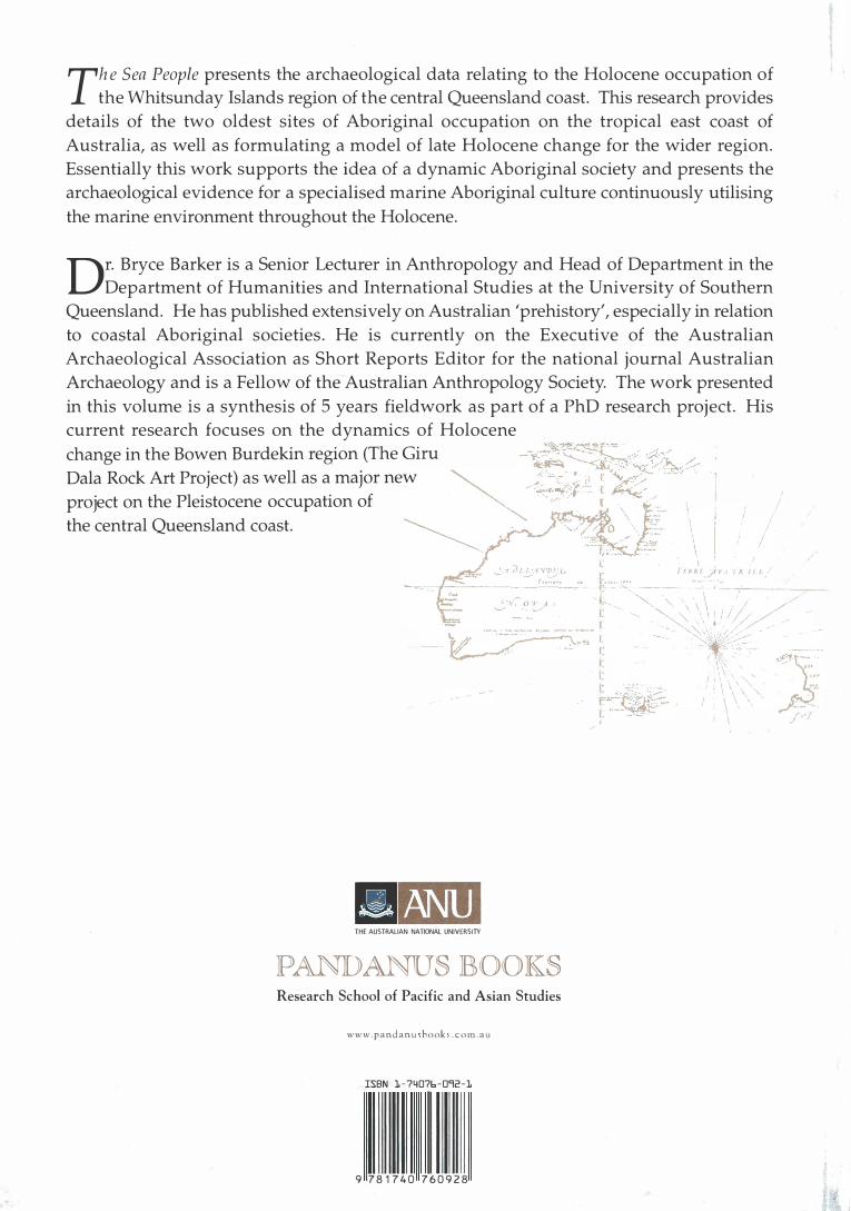
Th e Sea People presents the archaeological data relating to the Holocene occupation of
the Whitsunday Islands region of the central Queensland coast. This research provides
details of the two oldest sites of Aboriginal occupation on the tropical east coast of
Australia, as well as formulating a model of late Holocene change for the wider region.
Essentially this work supports the idea of a dynamic Aboriginal society and presents the
archaeological evidence for a specialised marine Aboriginal culture continuously utilising
the marine environment throughout the Holocene.
Dr. Bryce Barker is a Senior Lecturer in Anthropology and Head of Department in the
Department of Humanities and International Studies at the University of Southern
Queensland. He has published extensively on Australian 'prehistory', especially in relation
to coastal Aboriginal sod.eties. He is currently on the Executive of the Australian
Archaeological Association as Short Reports Editor for the national journal Australian
Archaeology and is a Fellow of the Australian Anthropology Society. The work presented
in this volume is a synthesis of 5 years fieldwork as part of a PhD research project. His
current research focuses on the dynamics of Holocene
change in the Bow.en Burdekin region
.(The Giru -���<;:f:�,--:-, ,
Dala Rock Art ProJect) as well as a maJor new .... � .. :�)/_ �: �
project on the Pleistocene occupation of ·� d • . · • t ·
· ·"�- \ the central Queensland coast. �. " ' \
\ .
I / f:ll. fl.f_Jt V 1 "I f.. 1 1 1 ,
, - I•
/
-.---·-.._'.-'f �I!_; 1 '-�·��-'� •• �, J:":" :_::•
� �(°' o � ' f ·- - . ·- - - - ... - -· - ........ I
\ · -�--- /-, \, . .' !//-l.# · �-� .. �L f. � · � - J: ':
\: 1: ;,...i_:�'-:_"";. �� [·· -��- . �
- m THE AUSTRALIAN NATIONAL UNIVERSITY
PANDANUS BOOKS Research School of Pacific and Asian Studies
www. p a n d a n u book . c o rn . a u
ISBN 1 - 7 4076 - 092 -1
9 7 8 1 7 4 0 7 6 0 9 2 8
' \ 1. ' :.-� ..
o:.J,,. -- · . .. .. �
"�
./•"/
I , ' ,\'
I I . I I \ \ ' \ ' I \