la moine river watershed ecosystem partnership
TRANSCRIPT

La Moine River Watershed Ecosystem Partnership
Up‐dating the La Moine River Watershed Implementation Plan
Two Rivers RC & D P.O. Box 87, Pittsfield, IL 62363
Telephone: 217‐285‐4114 July 31, 2008
Project Funding from Illinois Environmental Protection Agency
IEPA 319 Grant

Up‐dating the La Moine River Watershed Implementation Plan – 2008
Project Goals: 1. To determine sediment loadings, locations and where load reductions need to
occur 2. To ‘field’ verify existing La Moine River Best Management Practices within
“critical” subwatershed areas identified in the plan 3. To identify specific priority gully repair projects with specific landowners to
achieve load reductions and to update the current Watershed Plan.
Project and Report Deliverables:
1. Livestock assessment and inventory 2. Streambank erosion assessment and inventory 3. Gully erosion assessment inventory 4. Nutrient and sediment loadings and load reductions 5. BMP inventory and evaluation 6. Watershed Stakeholder and Focus Group Meetings 7. Field Verification of the Prioritization Model 8. Assessment Plan Update
2

Table of Contents Figures and Tables ..................................................................................................................... 4 Executive Summary................................................................................................................... 5 Livestock Assessment and Inventory ..................................................................................... 8 Streambank Erosion Inventory .............................................................................................. 15 Gully Erosion Inventory and Evaluation ............................................................................. 20 BMP Inventory and Evaluation, Summary of Watershed Loadings................................ 27 Willing Landowners ................................................................................................................ 32 Additional Information: Roadside Dumps in Fulton County........................................... 34 Appendices 1. Gully Study Data Sheet ..................................................................................................... 36 2. Meeting Summaries ........................................................................................................... 37
3
Figures and Tables Figures 1. Priority Rankings ................................................................................................................. 5 2. All Livestock Operations in Watershed.......................................................................... 10 3. Livestock Operations Having a Significant Impact ...................................................... 11 4. Livestock Operations by Subwatershed ......................................................................... 12 5. High Impact Livestock Operations by Subwatershed.................................................. 13 6. Map of Assessed Stream Segments ................................................................................. 17 7. Map of Most Severe Stream Segments............................................................................ 18 8. GIS File Map Example....................................................................................................... 19 9. Gully Study Areas.............................................................................................................. 22 10. Map‐Gully Locations McDonough County ................................................................... 23 11. Map‐Gully Locations Fulton County .............................................................................. 24 12. BMPs‐Location, Field Verification................................................................................... 27 13. Location, Extent and Type of BMPs ................................................................................ 28 14. Field Verified BMP Locations .......................................................................................... 31 15. Roadside Dumps in Fulton County ................................................................................ 34 Tables 1. Summary‐Acres and Stream Length of Livestock Operations...................................... 8 2. Summary‐Severity of Livestock Operations .................................................................... 9 3. Summary‐Stream Crossings, Acres of Runoff Retention, Wetland Restoration......... 9 4. Streambank Inventory Results ......................................................................................... 16 5. Streambank Stabilization Load Reductions‐10 Most Severe Sites .............................. 19 6. Streambank Inventory Data ............................................................................................. 19 7. Overall Streambank Inventory Results........................................................................... 21 8. Fulton County Streambank Inventory Results .............................................................. 21 9. McDonough County Streambank Inventory Results ................................................... 21 10. Key Factors Influencing Fulton County Gully Erosion................................................ 25 11. Summary Table: BMPs Visible from Road or Streambank Inventory ....................... 29 12. Summary Table: Field Verified BMP Locations in La Moine River Watershed
Plan....................................................................................................................................... 32 13. Summary of Pollutant Loading and Load Reductions................................................. 32 14. Willing Landowners .......................................................................................................... 33
4

Executive Summary
This report brings up‐to‐date the original “La Moine River Watershed Plan, 2006”, which addressed local stakeholder concerns related to water quality, erosion, wildlife habitat and education. Available and accessible data were analyzed to determine priority subwatersheds based on project goal areas. Subsequently, potential Best Management Practices (BMPs) were identified using
aerial photo interpretation, and expected load reductions were calculated. Although information provided in the watershed plan was extensive, data gaps did exist. Missing information included the extent and severity of gully and streambank erosion and the location andimpact of livestoperationsVerification ofBMPs outlined the plan was also needed. An IEPA 319 grant was pursued and
ock
. in
ingsFigure 1: Priority Rank
nding was acquired to address these data gaps and conduct sampling in
available
implementation.
fupriority subwatersheds (map above). The following report outlines methodologies and results from the assessment work. All raw data areto the local watershed group for use in grant applications and project

Two Rivers RC&D established a grant “Oversight Committee” to handdecisions that wer
le any e needed for this grant. The RC&D Council was the Grantee
of:
ip;
d
ional,
ocess, including:
and had final responsibility for the grant. The Oversight Committee consistedBrenda Middendorf, Access Illinois Outdoors Coordinator for Two Rivers RC&D; Beatrice Artis, RC&D Council member representing Schuyler County SWCD; Tim Sullivan, President of the La Moine River Ecosystem Partnershand Tharran Hobson, Brown County representative on the La Moine River Ecosystem Partnership. This committee met shortly after the grant was awardeto assign the project activities and timelines. The committee made recommendations on sub‐contracts that were awarded to: Jeff Boeckler with the University of Illinois, Hall Healy with Facilitated Solutions InternatMcDonough County SWCD, and Fulton County SWCD. A number of lessons were learned during this updating pr Things We Would Do the Same: Using SWCD staff to collect field data on the land was very effective. Not only did they gather the needed data, but they made landowner contacts.
e
es which d
rovements
From their contacts, we have a list of several landowners that want to construct conservation practices if cost‐share is available. This was felt to beffective because: 1) The SWCD staff are local; 2) They work for an established local unit that can be verified with a phone call; 3) The SWCD personnel have knowledge and experience with conservation practicthey can share. It was noted by the Fulton County SWCD staff that there habeen very little conservation work done in those sub‐watersheds in the past. Despite the fact that SWCD was not well known to landowners in the area, they were able to acquire permission to collect the field data. Conducting meetings with landowners in the evenings and outside of the planting and harvesting seasons
Identifying and asking for commitments from landowners to participate inreducing gully erosion
Asking willing landowners for suggestions of others that also might be willing to engage in imp
Data models developed for gully and streambank survey were effective
Things We Would Do Differently:
engage landowners and stakeholders did not work well. Very few of the target audience attended. Hall Healy was largely
Holding a public meeting to
6

responsible for those that attended. He followed up the invitation letters wperson phone calls. Collect slightly different attributes for livestock operations to allow for quicker data capture Capture polygon feature
ith
s for pasture boundaries rather than points Outreach, Education and Public Meetings: Various outreach and educational efforts were conducted during this project in e form of numerous one‐on‐one meetings with individual landowners as well
in e
etings included:
eople was held on Tuesday July 24, 2007 to inform landowners about SAFE, (State Acres for Wildlife), a relatively new
a
2. o discuss and determine approaches to identify Fulton County
thas public meetings for groups of landowners. The purpose of these gatherings was to inform them of the importance of managing and reducing gully erosion and of the various funding programs available to help them reduce erosion. It isclear that most are aware of the benefits of this practice, while some either don’thave financial resources to effect the improvements to their land or are reluctant to change. However, it also is clear that during the period of this grant, economics of area agriculture have shifted substantially, with more intense farming of corn and other crops for biofuels. Added to this is an increasedemand for U.S. crops from India and China. These factors are increasing thprice of corn and thereby making the land more valuable, thus augmenting incentives for control of erosion, as many landowners have stated in these discussions. The public me 1. A meeting of about twenty p
funding source to restore or enhance wildlife habitats. (See Appendix B forsummary.) On November 20, 2007 a “focus group” meeting of about fifteen people was conducted tlandowners willing to participate in grant programs for resolving gully erosion and related issues on their properties. (See Appendix B.)
7

Livestock Assessment and Inventory Methodology, Assessment Strategy and Results The location, size and observed impact on water quality of every confined and non‐confined hog and cattle operation was assessed using a windshield survey and a mobile GPS unit to record site specific data. We assessed a total of 9,284 road miles within the watershed. The following tables represent information collected during the survey as well a summary of findings for the watershed as a whole. Limitations of the survey
• In many cases the entire operation was not visible from the road; actual acreages and estimates may have been slightly under/over estimated; every attempt was made to avoid over‐estimating any values. Where an operation was almost entirely hidden from the road, a note was made and low values were applied to the data point in order to avoid over‐ estimating impact.
• Over time pasture operations are moved, modified or sold
Total Number of Livestock Operations in the La Moine River Watershed:
Table 1: Summary‐Acres and Stream Leng
Waterbody Acres
Name of stream or drainage where
operation is located
Approximate sizein acre
N/A 223,93
1,539
th of Livestock Operations
Stream Length
of operation s
Approximate length in feet of stream impacted
0 1,362,315 feet or 258 miles
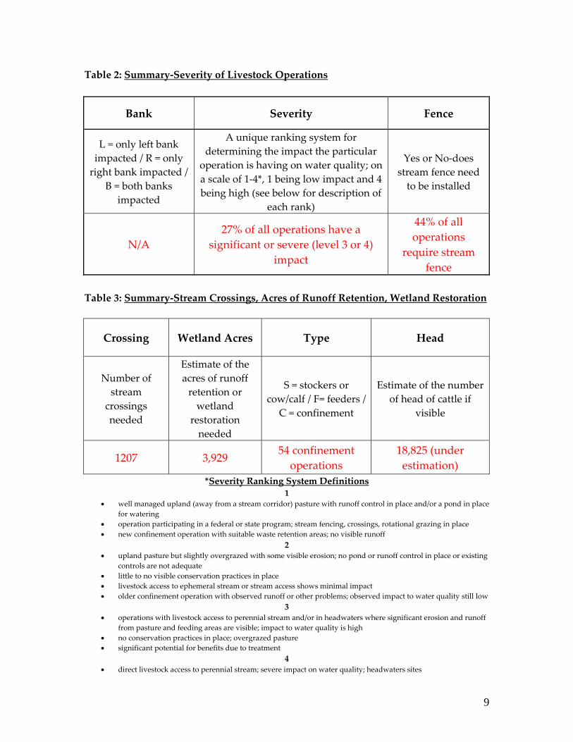
Table 2: Summary‐Severity of Livestock Operations
Bank Severity Fence
L = only left bank impacted / R = only right bank impacted /
B = both banks impacted
A unique ranking system for determining the impact the particular
operation is having on water quality; on a scale of 1‐4*, 1 being low impact and 4 being high (see below for description of
each rank)
Yes or No‐does stream fence need to be installed
N/A 27% of all operations have a
significant or severe (level 3 or 4) impact
44% of all operations
require stream fence
Table 3: Summary‐Stream Crossings, Acres of Runoff Retention, Wetland Restoration
Crossing Wetland Acres Type Head
Number of stream
crossings needed
Estimate of the acres of runoff retention or wetland
restoration needed
S = stockers or cow/calf / F= feeders /
C = confinement
Estimate of the number of head of cattle if
visible
1207 3,929 54 confinement operations
18,825 (under estimation)
*Severity Ranking System Definitions 1
• well managed upland (away from a stream corridor) pasture with runoff control in place and/or a pond in place for watering
• operation participating in a federal or state program; stream fencing, crossings, rotational grazing in place • new confinement operation with suitable waste retention areas; no visible runoff
2 • upland pasture but slightly overgrazed with some visible erosion; no pond or runoff control in place or existing
controls are not adequate • little to no visible conservation practices in place • livestock access to ephemeral stream or stream access shows minimal impact • older confinement operation with observed runoff or other problems; observed impact to water quality still low
3 • operations with livestock access to perennial stream and/or in headwaters where significant erosion and runoff
from pasture and feeding areas are visible; impact to water quality is high • no conservation practices in place; overgrazed pasture • significant potential for benefits due to treatment
4 • direct livestock access to perennial stream; severe impact on water quality; headwaters sites
9

• excessive bank erosion and direct waste runoff from pasture and feeding area • highest priority for treatment • feeding areas in a stream or creek
Figure 2: All Livestock Operations in Watershed
10

Figure 3: Livestock Operations Having a Significant Impact (Level 3 and 4)
11

Figure 4: Livestock Operations by Subwatershed
12

Figure 5: High Impact Livestock Operations by Subwatershed
13

Observations and Recommendations Landscape patterns within the La Moine River basin change dramatically from north to south and east to west. This seems to be the single most important factor influencing the impact of livestock operations on water quality. In the north east and southern portions of the La Moine where the landscape is older with rolling hills and deep gullies and where water seems less abundant, operations are much larger with livestock spread over larger areas. Due to the shortages in availability of summer water, ponds are constructed, keeping livestock out of riparian corridors. However, higher levels of gully erosion and erosion within timbered areas were observed in these areas. In the central and northwest portions of the watershed where the most productive and uniform ground is located, and where year round surface water seems more abundant, livestock are confined to stream corridors where the water is, away from ground being used for cultivation. Of the over 1,500 operations surveyed, less that 50 were observed to be limiting livestock access to streams, although in many cases this was not needed because of the upland location of many of these pastures. Although the number of confined hog and dairy operations is minimal, numerous new and very large hog buildings were observed. Almost every pasture operation includes some type of confined temporary feeding area; the location of these areas varied from flat ground to hill slopes to within streams. Little or no waste water runoff control was noted in any of these areas.
14

Streambank Erosion Inventory Methodology, Assessment Strategy and Results Selected reaches of four streams were surveyed for streambank erosion. These streams include: East Fork La Moine/Drowning Fork, Troublesome Creek, Camp Creek and Spring Creek. With the exception of Spring Creek, each stream surveyed is located within a “priority subwatershed” as identified in the La Moine River Watershed Plan. A total of 133,207 stream feet were assessed using IEPA methods for estimating streambank erosion. The above stream segments were selected for the following reasons: being within priority subwatersheds as identified in the La Moine River Watershed Plan; accessibility by canoe; and being representative of other headwater streams within the greater basin.
A GPS unit was used to collect data on bank height, lateral recession rates and soil texture. A GPS point was recorded at the start of each day, one for the left and one for the right bank. Observations of average lateral recession rate were made over uniform stream segments and the appropriate data recorded as another point file. A new point was created when visible changes in bank characteristics occurred, separately for the left and right banks if necessary. Bank length was calculated using GIS by measuring the distance between each point representing areas of similar bank characteristics. Other information was collected including the location of BMPs needed at a particular location, tile outlets and significant features. See the following sections for further discussion.
15

Total net erosion in tons/year and estimates of Nitrogen (N) and Phosphorous (P) loading were calculated using GIS and equations derived from IEPA’s load reduction spreadsheet. The following equation was used:
Total Tons = Length (feet) X Height (feet) X Lateral Recession Rate (feet/year) X Soil
Weight Dry Density (tons/feet3) N Load (lbs) = Total Tons X N concentration in Soil (0.002 lbs/lbs) X 2000 X
Correction Factor P Load (lbs) = Total Tons X N concentration in Soil (0.0006 lbs/lbs) X 2000
X Correction Factor Table 4: Streambank Inventory Results The following table represents results from the streambank inventory:
Total Net Erosion (tons/yr)
Average Height (feet)
Average Annual Recession
Rate
Total Length (in feet; both
banks)
Nitrogen Load (lbs/yr)
Phosphorous Load (lbs/yr)
3,276 3.75 Moderate‐
High 266,414 12,273 3,682
This represents approximately 24.6 pounds of sediment for every foot of eroding bank per year. Considering that the entire La Moine River basin (including some drainages that flow directly into the Illinois River) has 17,735,291 stream feet, at 24.6 lbs/feet of erosion, this would mean the basin could conservatively contribute over 200,000 tons of sediment annually from streambank erosion alone.
16

Figure 6: Map of Assessed Stream Segments (in red)
17

Of the 266,414 stream feet assessed, ten sites for a total of 910 feet require streambank stabilization as well as in‐stream grade control. Although streambank erosion is prevalent throughout, these 10 sites (in red on the map below) represent the most severe areas with the most realistic chance of receiving funding. Figure 7: Map of Most Severe Stream Segments
18

Table 5: Streambank Stabilization Load Reductions‐10 Most Severe Sites The following table represents load reductions to be gained from streambank
stabilization at the 10 most severe sites
Total Length stabilized (in
feet)
Total Net Erosion
Reduction (tons/yr)
Nitrogen Load Reduction (lbs/yr)
Phosphorous Load Reduction (lbs/yr)
910 69 277 83
Table 6: Streambank Inventory Data The following table represents additional data collected during the streambank inventory. More information on BMPs listed here can be found in the section “BMP inventory and evaluation; summary of watershed loadings”
Total Length (in feet; both banks)
Stream Length with Livestock Access (in
feet)
Number of Drain Tiles
Number of BMPs needed
266,414 38,054 or 14% of total stream length
68 91
Figure 8: GIS File Map Example The map below is an example of the GIS files created from the study. Blue areas represent potential wetland BMPs; brown areas are filter strips and the red line represents livestock operations.
19

Gully Erosion Inventory and Evaluation Methodology, Assessment Strategy, and Results A gully erosion inventory was completed within 2 subwatersheds identified in the La Moine River Watershed Plan as being “high priority” for erosion. One watershed is located in McDonough and one in Fulton County. All field work was completed by county SWCD employees and transferred to IDNR for processing. Gully locations and dimensions were collected using GPS and entered onto data sheets in the field (see Appendix A). The following is a list of variables collected in the field:
Latitude/longitude of gully A reference number Gully length, width, depth Soil texture Estimate of the number of years eroding Landowner willingness and additional comments (practice recommendations)
The following equations were used to estimate erosion rate and N and P loadings:
Total Tons = Length (feet) X Depth (feet) X Width (feet) X Soil Weight Dry Density (tons/feet3) / Number of Years Eroding
N Load (lbs) = Total Tons X N concentration in Soil (0.002 lbs/lbs) X 2000 X Correction Factor
P Load (lbs) = Total Tons X N concentration in Soil (0.0006 lbs/lbs) X 2000 X Correction Factor
20

Table 7: Overall Streambank Inventory Results
Total Number Gullies
Total Net Erosion (tons/yr)
Total N Load (lbs/yr)
Total P Load (lbs/yr)
Average Length (feet)
Average Width (feet)
Average Depth (feet)
628 22,668 90,662 27,199 244 5.9 2.3
Table 8: Fulton County Streambank Inventory Results
Total Number Gullies
Total Net Erosion (tons/yr)
Total N Load (lbs/yr)
Total P Load (lbs/yr)
Average Length (feet)
Average Width (feet)
Average Depth (feet)
571 20,993 83,972 25,192 147.5 6.4 2.36
Table 9: McDonough County Streambank Inventory Results
Total Number Gullies
Total Net Erosion (tons/yr)
Total N Load (lbs/yr)
Total P Load (lbs/yr)
Average Length (feet)
Average Width (feet)
Average Depth (feet)
57 1,673 6,690 2,007 1,214 1.5 1.2
Of the 571 eroding gullies, the highest recorded gully contributes 2,763 annual tons of erosion. This particular gully is 20 feet wide, 1.3 feet deep and 2,500 feet long. Total net erosion is 22,668 tons/year with a total recorded gully length for the entire study of 154,399 feet. It is important to note that a recommended practice was also recorded for each gully in the study areas. Results indicate that a simple grass waterway or diversion system will address the erosion resulting from a majority of these gullies. Grade stabilization and WASCBs were also recorded numerous times. What is important here is that 628 project locations have been identified that require some type of treatment.
21

Figure 9: Gully Study Areas McDonough County HUC 12 – 71300100601 Fulton County HUC 12 ‐ 71300030703
22

Figure 10: Map‐Gully Locations McDonough County‐HUC 71300100601
23

Figure 11: Map‐Gully Locations Fulton County‐HUC 71300030703
24

Results clearly show that the majority of gully erosion from the two study areas is occurring in Fulton County, almost twenty times that of the McDonough County watershed, with only ten times the number of gullies. Some of the key factors affecting these results include percentage of Highly Erodable Soil (HEL), land slope gully density, soil type and current landcover. The following table represents these factors for each subwatershed. Table 10: Key Factors Influencing Fulton County Gully Erosion
Subwatershed % HEL Average Slope (%)
Gully Density (#/acre)
Soil Landcover
71300030703 Fulton County
49.03 7.02 0.03 15% loess 54% Row Crop
71300100601 McDonough
County 4.43 0.91 0.002 0% loess
96% Row Crop
It is obvious that the study area in Fulton County has the highest rates of gully erosion given that the HEL percentage and average land slope is almost ten times that of McDonough County. Gully density is also significantly higher and although the total area percentage‐wise in row crop is highest in McDonough County, the rolling, steep topography in Fulton County easily lends itself to the formation of gullies. The ratio of average distance of eroding gullies to stream courses was also calculated. In Fulton County this dimension is 1162 feet and in McDonough County, 1557 feet. Fulton County has a maximum distance of 3559 feet and a minimum of 33 feet from a stream, while McDonough’s maximum is 5875 feet and minimum is 4.5 feet. Although McDonough’s minimum distance is 4.5 feet, data overall show that Fulton has a much higher percentage of gullies within a shorter distance to a stream, indicating a higher potential for eroded soil to reach a stream. Results from this study demonstrate the need to address gully erosion in the Fulton County watershed first, targeting the largest and most erodable gullies. Once gullies are successfully stabilized, very little soil continues to erode; and by addressing the identified gullies, sediment can be reduced by over 22,666 tons
25

annually. The result is significant in that it represents only 3% of the total land area of the greater La Moine basin. What this data does not necessarily show and what is important when comparing these two subwatersheds is that in McDonough County, the drainage area of crop ground contributing to these gullies is significantly higher. While gully erosion in McDonough is lower, this does not necessarily mean that the need to address these areas is any less than in Fulton. McDonough’s large drainage areas also contribute significant amounts of sheet and rill erosion not reflected in this report or in the statistics. Table #10 above shows that the area of crop ground in the McDonough watershed is almost twice that of Fulton. Typically, when addressing gully erosion, an entire field is evaluated to address all types of erosion occurring on the site. Therefore, tackling some of the areas in McDonough County may well lead to greater overall benefits and a reduction in net erosion, despite the fact that gully erosion is much higher in Fulton County.
26

BMP Inventory and Evaluation; Summary of Watershed Loadings BMP inventory and evaluation The two components of BMP information gathered in the field were: 1. Location, extent and type of Best Management Practice needed for a
particular site, where visible from the road or from the streambank inventory 2. Field verification of BMP locations identified in the La Moine River
Watershed Plan, where visible from the road Figure 12: BMPs‐Locations, Field Verification
27

1. Location, extent and type of Best Management Practice, visible from the road or from the streambank inventory The location, extent and type of BMP required were recorded during the livestock and streambank inventory, where visible. Figure 13: Location, Extent and Type of BMPs
28

Table 11: Summary Table: BMPs Visible from Road or Streambank Inventory
BMP TYPE Acres # High
PriorityMedium Priority
Low Priority
% Total Area
Critical Areas Seeding 1.54 2 1 1 0 0.03% Filter Strip 249.43 68 50 18 0 4.76% Grade Control 0.10 15 0 8 7 N/A Grass Waterway 136.24 64 33 23 8 2.60% Gully Stabilization 0.31 8 8 0 0 N/A Leaky Oil 0.12 2 2 0 0 N/A Prairie Restoration 73.87 11 2 6 3 1.41% Retention Basin 1.42 1 0 1 0 0.03% Riparian Buffer 4266.13 163 125 36 2 81.36% Streambank Stabilization 0.41 10 5 5 0 N/A TSI (Timber Stand Improvement) 159.47 3 0 0 3 3.04% Water and Sediment Control Basin (WASCB) 12.59 74 23 45 6 0.24% Wetland 341.86 79 49 24 6 6.52% Grand Total 5243.61 500 298 167 35 N/A % Priority 59.60% 33.40% 7.00%
Note: The above table shows ‘primary BMPs’ for the entire basin. Secondary BMPs and/or other comments were also recorded for each location, since for a given site, several practices may be appropriate. The following is a list of secondary BMPs associated with each one represented in the table Critical Areas Seeding
No secondary BMP Filter Strip
Wetland if hydric soils exist (noted in over 50% of Filter Strips) Gully stabilization Riparian buffer CRP and CREP practice if in areas eligible for these programs (i.e. in the 100 year floodplain
for CREP) Grade Control
Instream knick point Grass Waterway
CRP and CREP practice if in areas eligible for these programs (i.e. in the 100 year floodplain for CREP)
29
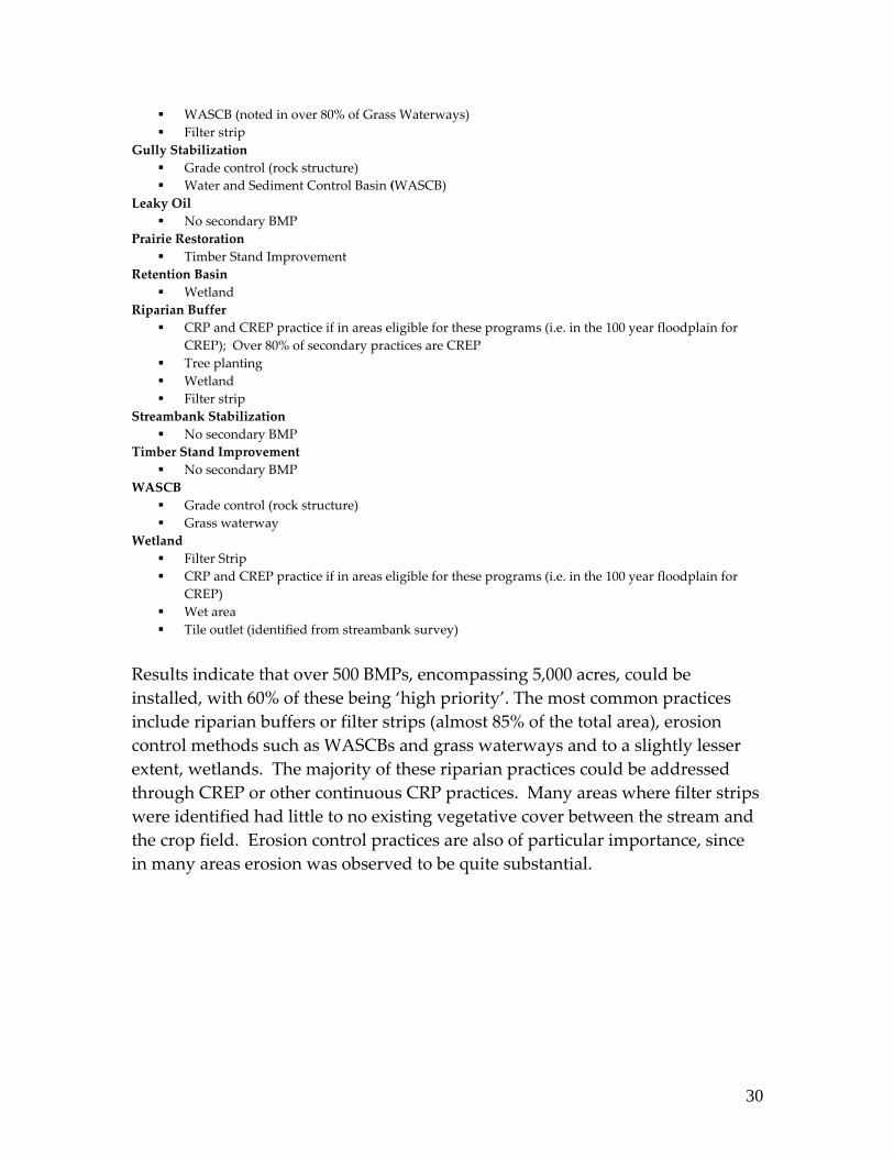
WASCB (noted in over 80% of Grass Waterways) Filter strip
Gully Stabilization Grade control (rock structure) Water and Sediment Control Basin (WASCB)
Leaky Oil No secondary BMP
Prairie Restoration Timber Stand Improvement
Retention Basin Wetland
Riparian Buffer CRP and CREP practice if in areas eligible for these programs (i.e. in the 100 year floodplain for
CREP); Over 80% of secondary practices are CREP Tree planting Wetland Filter strip
Streambank Stabilization No secondary BMP
Timber Stand Improvement No secondary BMP
WASCB Grade control (rock structure) Grass waterway
Wetland Filter Strip CRP and CREP practice if in areas eligible for these programs (i.e. in the 100 year floodplain for
CREP) Wet area Tile outlet (identified from streambank survey)
Results indicate that over 500 BMPs, encompassing 5,000 acres, could be installed, with 60% of these being ‘high priority’. The most common practices include riparian buffers or filter strips (almost 85% of the total area), erosion control methods such as WASCBs and grass waterways and to a slightly lesser extent, wetlands. The majority of these riparian practices could be addressed through CREP or other continuous CRP practices. Many areas where filter strips were identified had little to no existing vegetative cover between the stream and the crop field. Erosion control practices are also of particular importance, since in many areas erosion was observed to be quite substantial.
30

2. Field verification of BMP locations identified in the La Moine River Watershed Plan Best Management Practices were previously identified in the La Moine River Watershed Plan written in 2006. Separate from # 1 above, these BMPs were visually evaluated during the livestock inventory and coded as:
Yes – required and applicable to the particular site No – not needed Unknown – unable to see to determine yes or no
Figure 14: Field Verified BMP Locations
31

Table 12: Summary Table: Field Verified BMP Locations in the La Moine River Watershed Plan, where visible from the road
Status Number BMPs Area (acres) % of total # BMPs Yes 351 986 45% No 315 913 41%
Unknown 107 217 14% Summary of Pollutant Loading and Load Reductions A pollutant loading model for priority subwatersheds was developed for the La Moine River Watershed Plan (2006). The following table summarizes loadings and expected reductions as noted in the 2006 plan. Table 13: Summary of Pollutant Loading and Load Reductions
Total Load N (lbs/yr)
Total Load P (lbs/yr)
Total Load BOD (lbs/yr)
Total Load Sediment (tons/yr)
3,016,693 162,740 6,124,652 322,211
Total Load Reduction N
(lbs/yr)
Total Load Reduction P
(lbs/yr)
Total Load Reduction BOD
(lbs/yr)
Total Load Reduction Sediment
(tons/yr)
1,627,670 90,058 2,751,460 167,174
54% change 55% change 45% change 52% change
The total number of BMPs verified in the field is roughly half of what was included in the original load reduction estimates of the 2006 Watershed Plan. Given this, one could expect that net load reductions should also be roughly half of what was previously stated, as is demonstrated above.
Willing Landowners
As part of the survey and through subsequent discussions with landowners, contract personnel identified almost twenty who would like to repair gullies on their property. Many of them had previously applied remedies to their land, such as dry dams and ponds, and are motivated to apply additional remedial action. A number of landowners have their own equipment and are willing to apply this machinery and their own labor towards the cost sharing portion of a
32

grant, as a way of minimizing out‐of‐pocket costs. Some are tenants farming land of others, some work their own and other people’s property. Some work together as a group to farm their own and other land. They recognize the damage that gullies cause to the land, their crop yields and income and understand the benefits of reducing erosion and improving water quality. These landowners described their gully problems in various ways: as having numerous areas on their own property and as being effected by gullies on neighboring land. One person indicated he had a “gully the size of a combine.” A group of eighteen landowners and operators volunteered to put their names on a grant application for new funding to remedy gullies on their property. They, in turn, recommended numerous other individuals who might be candidates for a grant application. They are representative of different areas within Fulton and McDonough County such as Astoria and Ipava. Those who volunteered for the next round of funding are in the table below. Table 14: Willing Landowners
Last Name First Name City Beekman Wayne Astoria Beekman Stephen Havana Beekman Gale Astoria Brockley William Astoria Cheney Susan West PointCox Roger Astoria
Dewees Paula/Josh Astoria Elks Joe San Jose
McCausland Vernon Havana Oest Richard Astoria
Phillips Linda Astoria Porter Raymond Ipava Porter John W. Ipava Porter Sam Ipava
Thompson Don Ipava Webb James Astoria Webb Greg Astoria Welker Franklin Astoria
33

Additional Information: Roadside Dumps in Fulton County Figure 15: Roadside Dumps in Fulton County
In addition to BMPs mentioned above, 29 roadside dumps were identified and recorded during the survey, 12 of which are severe and require immediate attention. Two of these sites have since been cleaned up with the help of local volunteers. The remaining sites have been forwarded to staff at the IEPA I‐RID program. To date, all have been inspected and placed on the I‐RID list, with several sites currently being cleaned up or entirely cleaned up.
34

A 32 yard roll‐off bin and two pick‐up trucks were completely filled by local volunteers in the first annual La Moine River roadside dump cleanup. Special assistance was provided by Waste Management Inc., two local Road Commissioners, and Volunteer Now. Waste removed from these sites included: paint and aerosol cans, glass, metal, old TVs, batteries, tires, plastic bottles, and computer parts. Another cleanup was planned for May 2008.
35

Appendix A
Gully Study Data Sheet
36

Appendix B
Meeting Summaries
La Moine River Ecosystem Partnership
Section 319 Project
Meeting Summary, Project Report #1‐September 25, 2006
Present: Jeff Boeckler‐IDNR; Hall Healy‐Facilitated Solutions International; Brenda Middendorf, Martha Sheppard‐Two Rivers R.C. & D. The following is a summary of a conference call meeting to establish the program and timetable for the La Moine River Section 319 project authorized by the Illinois Environmental Protection Agency (IEPA) August, 2006. Project Goals 4. To determine sediment loadings, locations and where reductions need to
occur 5. To ‘field’ verify existing La Moine River Best Management Practices within
“critical” subwatershed areas identified in the plan 6. To identify specific priority projects with specific landowners to achieve the
load reductions and to update the current Watershed Plan. Project Activities 1. Jeff Boeckler will conduct ‘windshield’ surveys and develop an inventory of
the watershed’s cattle and hog operations in October 2006 a. The sampling method for this survey will be driving by all such
operations on the road without entering onto individual properties. A GPS position will be recorded and observations made, where possible, on the impact those operations are having on water quality and riparian habitat
2. Conduct a survey of the watershed’s gullies to determine major areas of erosion within selected subwatersheds in McDonough and Fulton Counties from November through January

a. Soil and Water Conservation Districts (SWCDs) will be asked to assist in collecting data and narrowing down the areas needing to be surveyed based on their existing knowledge
b. Jeff Boeckler will help as needed c. The surveying will be discussed with landowners beforehand to obtain
permission to go onto their property and to discuss the reasons for and benefits of the program; one motivation for landowners will be the potential for additional funds available to address the issue through the Conservation Practices Program (CPP)
d. Hall Healy will set up meetings with landowners and assist in making calls on them; Jeff Boeckler also will assist in talking with some of the landowners
e. This phase will begin as soon as harvesting is finished and there is approval from the SWCDs
f. A meeting will be held in October 2006 with the SWCDs to discuss the survey and obtain their ideas on the appropriate approach (see below)
g. The sampling method for this gully survey will include personal visits to all properties identified by SWCD offices as having significant gullies; Data collected in the field will include but not be limited to: gully location (GPS location), length, depth, width, slope, crop residue and soil test data if available.
3. Field verify Best Management Practices (BMP) in the La Moine plan a. Jeff Boeckler will drive the McDonough and Fulton county areas and
assess conditions from the road as an initial screening b. Jeff Boeckler will discuss conditions on individual properties with
landowners identified c. Some properties will have been identified previously during the cattle,
hog and gully surveys d. The sampling method will be a combination of analyzing data from the
cattle and hog and gully surveys, one‐on‐one discussions with SWCD personnel and with landowners and the field driving survey specifically for this activity
4. Conduct one‐on‐one, focus group and large group meetings with stakeholders, including willing landowners: to identify their issues and concerns; to identify and confirm/reconfirm willing landowner commitment; and to work with them on developing specific projects to reduce locations and amounts of erosion a. There will be a meeting on October 24, 2006 with SWCD staff and Board
members (once the date is confirmed with them), Jeff Boeckler, Hall Healy, Brenda Middendorf, Martha Sheppard and other decision makers
38

as appropriate to review this project, discuss goals, activities and approaches, in order to ensure participants are on the same wavelength
b. Others to consider having to this meeting include: NRCS (Sharon), Farm Bureau (asking Glenna how to approach; Carlos Hanson‐McDonough); FSA (Rob Cline, Joe Earlanson‐McDonough); having good relationships with these organizations will help in conducting this project
5. Conduct a streambank survey in the Spring of 2007 to accompany the gully survey a. Jeff Boeckler will conduct this survey with assistance of volunteers,
potentially including the help of Pat Sullivan b. The sampling method will be a survey in canoes and kayaks of selected La
Moine River tributaries (not the main stem); Data collected will include but not be limited to bank height, length location (GPS position) and severity.
6. Prepare and submit quarterly reports to IEPA, as required by terms of the grant a. Hall Healy will be responsible for preparing these reports, using data
provided by other team members b. Reports will be reviewed by appropriate team members prior to submittal
to IEPA c. This report, the first one of the project, will be submitted to the La Moine
Board at their 10/15/06 meeting and to IEPA Other Items • Martha will forward copies of the La Moine partnership timesheet to Jeff and
Hall for their use. The project has been approved and is beginning immediately
• Hall will edit the La Moine plan Respectfully submitted, Hall Healy Principal Facilitated Solutions International 847‐373‐7770, [email protected] October 12, 2006 Attachment 1 ‐ Project Action List, Responsibilities Attachment 2 ‐ Project Timeline
39

Attachment 1 La Moine River Project Action List, Responsibilities and Timeline
Activity Respon‐
sibility Timetable Status
Provide watershed maps of critical areas to 2 Rivers RC&D
JB SAP Complete‐9/25/06
Conduct cattle, hog windshield survey
JB 10/06 Begun in October
Conduct gully survey JB, with SWCD
11/06, 12/06, 1/07, 2/07,
3/07
Set up landowner meetings regarding gully survey
HH, some JB assistance
10/06
Obtain willing landowner contact information, including some from the cattle and gully surveys
HH with MS/SWCDs,
JB lists
10/06
Conduct meeting with SWCD staff, Board, JB, HH, BM, MS about project • Martha will talk with SWCDs
about the meeting
HH
MS
Afternoon of 10/24/06
Field verify BMPs JB 10/06, 2007 Conduct stakeholder/willing landowner meetings • one‐on‐one • large meetings‐100 or so people • focus groups
HH JB
Oct‐Dec 06 Fall 06, Spr 072/07, 2/08
Conduct streambank survey‐La Moine tributaries only
JB, Volunteers
Spring 2007
Collect up‐to‐date soils data JB In conjunction with gully and BMP survey
Prepare report for IEPA and La Moine partnership Board meeting
HH Prior to 10/15/06
This report, in final form, is intended to serve that purpose‐
40

completed 10/12/06 Prepare and submit quarterly reports to IEPA
HH Specific dates to be
established
Conduct edit of the La Moine plan HH 11/30/06 Send La Moine partnership timesheet to JB and HH
MS SAP
41

La Moine River Ecosystem Partnership Project Timeline‐Major Activities
Activity Q 4 2006 Q 2 2007 Q 3 2007 Q 4 2007 Q 1 2008 Q 2
2008Q 3 2008
Q 4 2008
Cattle, hog survey
Gully survey
Landowner meetings • one‐on‐
one • large
meetings
• focus groups
Field verify BMPs
Streambank survey
Soils data collection
Quarterly reports

La Moine River Ecosystem Partnership
Section 319 Project
Meeting Summary, Project Report #2‐November 2, 2006
Present: Jeff Boeckler‐IDNR; Hall Healy‐Facilitated Solutions International; Greg Jackson‐McDonough County SWCD/NRCS, Dave King‐Prairie Hills Resource Conservation Development, Cindy Moon‐McDonough County SWCD/NRCS, Martha Sheppard‐Two Rivers R.C. & D. The following is the summary of a meeting to initiate the La Moine partnership 319 project, discuss project steps and approaches to achieving those steps. Project Goals 7. To determine sediment loadings, locations and where reductions need to
occur 8. To ‘field’ verify existing La Moine River Best Management Practices within
“critical” subwatershed areas identified in the plan 9. To identify specific priority projects with specific landowners to achieve the
load reductions and to update the current Watershed Plan. Project Steps Discussed 1. Refining the loading model with field data
a. Jeff Boeckler is now in the process of surveying all hog and cattle operations in the watershed and four specific sub watersheds for other non point pollution sources‐including gullies
b. The 4 sub basins are Camp Creek, East Fork, Spring Lake and the upper portion of Troublesome Creek
c. Jeff has observed that only 2 of 300‐400 operations surveyed to‐date have flood fencing
d. The purpose of this phase is to determine specific locations for BMPs e. This work will help the State focus the use of CPP funds with “targeted
funds in targeted areas” f. Fulton County personnel (Kim Smale and Andy Karrick) need to be
approached to join the project 2. Developing a list of willing landowners

a. If a landowner has an active gully, for instance, it will be helpful to determine why they are not enrolled in CREP or other representative program and how can we get them enrolled
b. Jeff Boeckler will prepare and map showing locations surveyed; Hall Healy, with assistance from Cindy Moon, Duane Mansir and others will develop a willing landowner list for implementing BMPs
3. There is potential for contracting with the McDonough and Fulton County SWCDs, or the State Water Survey for some work on this project
4. Contract Advisory Committee a. This committee will provide oversight for the entire project b. One responsibility of the committee is to see that information is kept
confidential; raw data containing individual property owner names will be maintained within the watershed
Other Items 1. It would be helpful to coordinate meetings involving the various projects,
such at the La Moine 319 grant and the Spring Lake TMDL, to minimize confusion by stakeholders, leverage opportunities and maintain costs for these meetings
2. Another 319 grant has been obtained for the Spring Lake TMDL project; data from the La Moine project will help support the TMDL work a. Greg is preparing a list of landowners for this project
3. Another grant has been received by the partnership to conduct an awareness day
4. Dave King is pursuing an IEPA Brownfields grant 5. There is a USEPA “Targeted Watershed Program” initiative, with 20 some
grants being awarded nationwide. Its purpose is to help implement local plans with on‐the‐ground BMPs. Illinois did not receive one of them during the last grant cycle, so it stands a good chance of receiving one this time around. Proposals are due to the State by November 6, 2006. A few grant applications are in progress, one in particular for the La Moine area. a. BMPs being focused on for this grant include: WASCOBS, fencing, cattle
crossings, waterways, riparian buffers, Timber Stand Improvements (TSI) wetlands‐created and restored, and tree planting.
6. USDA is funding Purdue University to conduct a survey of changes in attitudes among watershed stakeholders due to various planning and BMP implementation activities to determine effectiveness of the watershed protection efforts. La Moine is likely to be a candidate for one of the surveys.
44

Action Items 1. Approach Kim Smale and Andy Karrick of Fulton County to join the project‐
Cindy Moon Respectfully submitted, Hall Healy Principal Facilitated Solutions International 847‐373‐7770, [email protected] November 5, 2006 Attachment 1 ‐ Project Action List, Responsibilities (new items added in red) Attachment 2 ‐ Project Timeline
45

Attachment 1 La Moine River Project Action List, Responsibilities and Timeline
Revised 11/5/06
Activity Responsibility
Timetable Status
Provide watershed maps of critical areas to 2 Rivers RC&D
JB SAP Complete‐9/25/06
Conduct cattle, hog windshield survey
JB 10/06 Begun in October
Conduct gully survey JB, with SWCD
11/06, 12/06, 1/07, 2/07,
3/07
Set up landowner meetings regarding gully survey
HH, some JB assistance
10/06
Obtain willing landowner contact information, including some from the cattle and gully surveys
HH with MS/SWCDs,
JB lists
10/06
Conduct meeting with SWCD staff, Board, JB, HH, BM, MS about project • Martha will talk with SWCDs
about the meeting
HH
MS
Afternoon of 10/24/06
Conducted 11/2/06
Field verify BMPs JB 10/06, 2007 Conduct stakeholder/willing landowner meetings • one‐on‐one • large meetings‐100 or so people • focus groups
HH JB
Oct‐Dec 06 Fall 06, Spr 072/07, 2/08
Conduct streambank survey‐La Moine tributaries only
JB, Volunteers
Spring 2007
Collect up‐to‐date soils data JB In conjunction with gully and BMP survey
Prepare report for IEPA and La Moine partnership Board meeting
HH Prior to 10/15/06
Completed 10/12/06
Prepare and submit quarterly HH Specific dates
46

reports to IEPA to be established
Conduct edit of the La Moine plan HH 11/30/06 Send La Moine partnership timesheet to JB and HH
MS SAP Done
Contact Fulton County (Kim Smale, Andy Karrick) to assist with the project
CM (?) SAP
47

La Moine River Ecosystem Partnership Project Timeline‐Major Activities
Activity Q 4 2006 Q 2 2007 Q 3 2007 Q 4 2007 Q 1 2008 Q 2
2008Q 3 2008
Q 4 2008
Cattle, hog survey
Gully survey
Landowner meetings • one‐on‐
one • large
meetings
• focus groups
Field verify BMPs
Streambank survey
Soils data collection
Quarterly reports

La Moine River Ecosystem Partnership Section 319 Project
Project Report #3‐June 30, 2007
The following is a summary of the La Moine River Partnership 319 project as of June 30, 2007. Tasks and schedules have been revised based on accomplishments of the project to‐date. The summary has been reviewed by Jeff Boeckler, IDNR, Martha Sheppard, SWCD‐McDonough County, and Hall Healy, Facilitated Solutions International. Project Goals 10. To determine sediment loadings, locations and where reductions need to
occur 11. To ‘field’ verify existing La Moine River Best Management Practices within
“critical” subwatershed areas identified in the plan 12. To identify specific priority projects with specific landowners to achieve the
load reductions and to update the current Watershed Plan. La Moine River Partnership Activities Field Surveys • Jeff Boeckler, IDNR, has surveyed approximately 1,500 livestock operations
and over 500 additional Best Management Practices (BMPs). He has verified 90% of ʺexistingʺ BMPs. Most were visible from the road. About one half of those verified do not require BMPs; of the other half, they either require BMPs or will need additional time and funds to visit specifically for verification of whether or not they need BMPs.
• The list created by the above BMP field survey was used to develop another list of potential candidates for State Acres for Wildlife (SAFE) and other funds; these people are being invited to a meeting in July to explain SAFE and other financial incentive programs (see ‘Water Quality Related Activities’ below).
• The soils association and type data survey was completed and awaits finalizing of the gully work (see below) to identify gully BMPs.
• Andy Karrick has completed about 66% of the gully survey in Fulton County, mostly the larger land parcels. Andy indicated that they found more gullies than expected from the aerial survey, either because some gullies weren’t

visible from the air or because they had grown in size since the aerial was conducted. He says that this work could become a model for estimating erosion rates in areas with similar terrain and loess type soil. Duane Mansir indicates that he has completed about 50% of the gully study in McDonough County. His findings to‐date suggest that the situation in McDonough County is less severe that previously thought, with more mega‐rills than gullies. They expect to complete the field work by August 2007, with a CD of GPS points and list of willing landowners available in September or October.
• The stream bank erosion inventory is complete – approximately 30 miles has been inventoried. Jeff is working on post processing the stream bank data, with an estimated completion date of February 2008.
Water Quality Related Activities • Livestock Initiative‐$250,000.00 in funds have been secured from IEPA’s 319
program for livestock management in McDonough County. An additional $750,000 is being sought from other agencies. Funds will be used to improve grazing operations, exclude livestock from streams and restore riparian habitat on private ground within the North Fork La Moine subwatershed. Other partners could be C‐2000, Fish and Wildlife and NRCS. We will need to identify willing landowners for the project.
• Funds have been secured through IDNR and U of I Extension to construct a series of waste treatment lagoons/wetlands in a small livestock feeding area (hogs and cattle). The total project cost is $9,500.00 and will eliminate the direct runoff of raw animal waste into an adjacent stream.
• A letter has been compiled (see Attachment 3) for sending to potential willing landowners to participate in the SAFE (State Acres for Wildlife) program of the FSA. It invites landowners to a meeting in Macomb on July 24, 2007 to learn more about SAFE and other financial incentives for restoring and enhancing habitat. IDNR, FSA and other appropriate agency personnel will be present at the meeting to explain these programs and promote enlisting in them. See Attachment 4 for a draft agenda of that meeting.
• There will be a Dump Cleanup Day on July 28, 2007. Two major dumps in McDonough County were identified by John Cox. One is on the East Fork near Bardolph and the other is in the southeast corner of Argyle. The Volunteer NOW program out of Macomb will serve as a partner and help direct volunteers to our project. Jeff Boeckler is working with Keister Tire to provide a tire collection spot for used tires that are retrieved. Kim Erndt is working with local township officials to get use of staff and trucks to help. IRID will be contacted about providing dumpsters for the event. Scott
50

McConnell and Chuck Ehlschlaeger will help promote the program with WIU students and offer extra credit for participating. John Cox will contact boy scouts to promote the program. While this project is not directly related to the grant, it evolved from those activities.
Watershed Model • IEPA LEAP grant funds of $500 were used to purchase a watershed model.
The model has been employed for educational programs around the area. To schedule the model for your event, contact Pat Sullivan.
Respectfully submitted, Hall Healy Principal Facilitated Solutions International 847‐373‐7770, [email protected] June 29, 2007 Attachment 1 ‐ Project Action List, Responsibilities Attachment 2 ‐ Project Timeline Attachment 3 ‐ SAFE Letter to Landowners Attachment 4 ‐ Draft Agenda for SAFE Meeting
51

Attachment 1 La Moine River Project Action List, Responsibilities and Timeline
As of June 30, 2007 (revised items in red)
Activity Respon‐sibility
Timeline Status
Conduct cattle, hog windshield survey
JB 10/06 Complete
Conduct gully survey JB, with SWCD
8/07‐field work
10/07‐analysis
66% done
Obtain willing landowner contact information, including some from the cattle and gully surveys
HH with MS/SWCDs,
JB lists
10/07 An initial list has been developed; it will be enlarged based on SAFE meeting, gully
survey Conduct meeting with SWCD staff, Board, JB, HH, BM, MS about project • Martha will talk with SWCDs
about the meeting
HH
MS
10/24/06 Done‐11/2/06
Field verify BMPs JB 2007 Complete Conduct stakeholder/willing landowner meetings‐for gully, other work • one‐on‐one • large meetings • focus groups
HH JB
Oct‐Dec 07 7/24/07, 3/08 Fall 07, 2/08
See above‐SAFE meeting
Conduct stream bank survey‐La Moine tributaries only
JB, Volunteers
Spring 2007 Complete
Collect up‐to‐date soils data JB Summer 2007 Complete Prepare report for IEPA and La Moine partnership Board meeting
HH Prior to 10/15/06
Complete‐10/12/06
Prepare and submit quarterly reports to IEPA
HH 6/30/07 9/30/07 12/31/07 3/31/08 6/30/08
52

53
Edit the La Moine plan, add new findings
HH 3/31/08
Contact Fulton County (Kim Smale, Andy Karrick) to assist with the project
CM SAP Complete

54
Attachment 2‐La Moine River Ecosystem Partnership Project Timeline‐Major Activities
Activity Q 4 2006 Q 2 2007 Q 3 2007 Q 4 2007 Q 1 2008 Q 2 2008 Q 3 2008 Q 4 2008
Cattle, hog survey Gully survey
Landowner meetings one‐on‐one •large meetings• focus groups •
Field verify BMPs Streambank survey
Soils data collection Quarterly reports

Attachment 3 SAFE Letter to Landowners
July 1, 2007 Dear Landowner: As an owner of farm land within the La Moine River Watershed, we would like to invite you to a meeting on Tuesday July 24, 2007 at 7:00 pm to learn about a new funding source to restore or enhance wildlife habitats. The La Moine River Ecosystem Partnership is sponsoring this request for funding as part of its on‐going work to enhance natural resources in the watershed. Funds will come from an extension of the USDA Farm Service Agency’s (FSA) Conservation Reserve Program (CRP) called SAFE‐State Acres for Wildlife. Existing CRP practices and framework will apply. Grants will be available for soil rental payments, land management and restoration of whole fields, stream and wetland buffers, trees and grass that help wildlife and will apply to CRP eligible cropland. They will pay up to 50% cost share for management required to maintain vegetation, such as prescribed burns, and up to 90% cost share to prepare habitat and plant vegetation for wildlife. Contracts will run from 10‐15 years, depending on practice type. IDNR and McDonough County FSA personnel will be developing a SAFE grant proposal in time for the September 15, 2007 deadline. Therefore, we want to make sure you have the necessary information in time to decide whether you would like to have your land included in the application. At the upcoming meeting, in addition to SAFE, we also will discuss other programs available to you such as the Conservation Reserve Enhancement Program (CREP) and Conservation‐2000. Agency personnel, including County FSA Executive Director Joe Erlandson, will be on hand to present these programs and answer your questions. The meeting will be at:
7:00 pm on Tuesday July 24, 2007 Community Room, Macomb City Hall, 232 East Jackson, Macomb 61455‐0337
(Refreshments will be served)
Please contact Martha Sheppard at 217‐285‐4114 to let her know that you will be attending or that you cannot and would like to talk with someone about these programs.
55

Thank you very much. We look forward to seeing you on July 24th! Sincerely, Tim Sullivan Chairman La Moine River Ecosystem Partnership
56

Attachment 4 La Moine River Watershed Partnership State Acres for Wildlife (SAFE) Meeting
Tuesday July 24, 2007 at 7:00 pm
Community Room, Macomb City Hall, 232 East Jackson, Macomb 61455‐0337
Agenda
Purpose: to learn about funding sources to restore or enhance wildlife habitats • Introductions • Explanation of the USDA Farm Service Agency’s (FSA) Conservation Reserve
Program (CRP) called SAFE‐State Acres for Wildlife • Overview of the Conservation Reserve Enhancement Program (CREP) and
Conservation‐2000 programs • Questions and answers • Opportunity for one‐on‐one answering of questions about applicability of
programs to individual participants in the meeting by agency experts
(Refreshments will be served)

La Moine River Ecosystem Partnership Section 319 Project
Project Report #4, September 15, 2007
The following is a summary of the La Moine River Partnership 319 project as of September 15, 2007. Tasks and schedules have been revised based on accomplishments of the project to‐date. The summary has been reviewed by Jeff Boeckler, IDNR, Martha Sheppard, SWCD‐McDonough County, and Hall Healy, Facilitated Solutions International. Project Goals 13. To determine sediment loadings, locations and where reductions need to occur 14. To ‘field’ verify existing La Moine River Best Management Practices within “critical”
subwatershed areas identified in the plan 15. To identify specific priority projects with specific landowners to achieve the load
reductions and to update the current Watershed Plan. La Moine River Partnership Activities Field Surveys • Jeff Boeckler, of IDNR completed surveying over 1,500 livestock operations in
McDonough County. The map in Attachment #1 demonstrates the rough locations of those operations. The survey covered 9,284 road miles. Initial results of the field work indicates that with about 30% of the total 1,500 operations, or about 258 miles of county streams, there have been direct and severe impacts on water quality. One half of all 1,500 operations appear to be too far from stream locations to have an impact. Thus, the implication is that over one half of the remaining operations (30% of total operations) do have severe impact.
• As part of Jeff Boeckler’s survey, he sampled 30 miles of stream banks for erosion. Fifty locations were identified as needing Best Management Practices (BMPs), such as filter strips, tree plantings or grade/erosion control structures.
• Currently, Jeff is posting the survey results, which will include calculation of pollutant concentrations, load reduction and specific project potential, updates on BMPs in the La Moine River Partnership Plan and a map of locations. Data on specific locations and names will be available to the La Moine River Partnership.
• Duane Mansir and Tim Royer have completed the McDonough County gully survey.
58

• Andy Karrick has completed field work in identifying 600 gully locations in Fulton County. While there are additional gullies to be identified, it is clear at this point that almost no one uses erosion control in the county. As a consequence, there is a fairly severe sediment load in the area. According to Jeff Boeckler, this creates good potential for a grant application to focus funds on improving the situation in Fulton County.
Meetings • On July 24th a meeting was held in Macomb to explain features of the State Acres for
Wildlife (SAFE) and other funds and financial incentive programs. About twenty people attended the meeting. Afterwards, it was decided not to apply for a SAFE grant at this time since all the attendees are eligible for CREP and other funds. Several people contacted Jeff Boeckler after the meeting to learn more details about applicable programs.
Project Results to‐date As a result of the project to‐date, several positive conclusions have been observed and activities have occurred, including: • Gullies that are causing severe erosion have been identified • Two hundred BMP locations have been identified • Forty roadside illegal dumping locations have been identified and on August 10th
volunteers cleaned up one of these dumps, with assistance from County Commissioners, who loaned equipment for the day and Waste Management Corporation that loaned a roll off container. Another dump was partially cleaned up. This project received significant local and media publicity, with an article being placed in the Macomb Journal.
• Repeatedly during the survey, Jeff Boeckler was asked by landowners about the work he was doing. As a consequence, several of them have gone into their local SWCD office to learn more about the conservation and financial incentive programs available.
Respectfully submitted, Hall Healy Principal Facilitated Solutions International 847‐373‐7770, [email protected]
59

September 17, 2007 Attachment 1 – Map of surveyed McDonough County livestock operations Attachment 2 ‐ Project Action List, Responsibilities Attachment 3 ‐ Project Timeline
60

Attachment 1 – Map of Surveyed McDonough County Livestock Operations
61

Attachment 2 La Moine River Project Action List, Responsibilities and Timeline
As of September 15, 2007 (revisions in red)
Activity Respon‐sibility
Timeline Status
Conduct cattle, hog windshield survey
JB 10/06 Complete
Conduct gully survey JB, with SWCD
8/07‐field work
10/07‐analysis
Almost complete
Obtain willing landowner contact information, including some from the cattle and gully surveys
HH with MS/SWCDs,
JB lists
10/07 An initial list has been developed; it will be enlarged based on SAFE meeting, gully
survey Conduct meeting with SWCD staff, Board, JB, HH, BM, MS about project • Martha will talk with SWCDs
about the meeting
HH
MS
10/24/06 Done‐11/2/06
Field verify BMPs JB 2007 Complete Conduct stakeholder/willing landowner meetings‐for gully, other work • one‐on‐one • large meetings • focus groups
HH JB
Oct‐Dec 07 7/24/07, 3/08 Fall 07, 2/08
SAFE meeting complete
Conduct stream bank survey‐La Moine tributaries only
JB, Volunteers
Spring 2007 Complete
Collect up‐to‐date soils data JB Summer 2007 Complete Prepare report for IEPA and La Moine partnership Board meeting
HH Prior to 10/15/06
Complete‐10/12/06
Prepare and submit quarterly reports to IEPA
HH 6/30/07 9/30/07 12/31/07 3/31/08 6/30/08
62

Edit the La Moine plan, add new findings
HH 3/31/08 12/31/07
Contact Fulton County (Kim Smale, Andy Karrick) to assist with the project
CM SAP Complete
63

Attachment 3‐La Moine River Ecosystem Partnership Project Timeline‐Major Activities
Activity Q 4 2006 Q 2 2007 Q 3 2007 Q 4 2007 Q 1 2008 Q 2
2008Q 3 2008
Q 4 2008
Cattle, hog survey
Gully survey
Landowner meetings • one‐on‐
one • large
meetings
• focus groups
Field verify BMPs
Streambank survey
Soils data collection
Quarterly reports

La Moine River Ecosystem Partnership November 20, 2007 Focus Group Meeting Summary
Present: Deb Baker, Jeff Boeckler, Bob Champlin, Dan Farr, Andy Karrick, Bernard McCance, Marty McManus, Keith Rohrer, Martha Sheppard, Kim Smale; facilitator‐Hall Healy Meeting Purpose: To discuss and determine approaches to identify Fulton County landowners willing to participate in grant programs for resolving gully erosion and related issues on their properties. All Board members present at this meeting indicated an interest in pursuing grant applications to bring funds into the County to address the gully issues. Jeff Boeckler of IDNR indicated that he can develop the application, do some outreach and help to push the application “through the bureaucracy”. Hall Healy also can assist with the grant application process. Observations from Field Survey Work There are some high density livestock operations in the County‐Otter Creek in particular could use cost‐share and assistance to address their issues
The exact address information obtained from the field survey work will not be turned into the agencies.
About 700 acres of BMPs were identified in the field work Illegal dump sites, mostly with tires and appliances, were identified and J. Boeckler is working to have them cleaned up as well; meeting participants suggested people contributing to these sites should be fined, that one of the most effective ways of dealing with them is to contact them individually, perhaps through the local sheriff.
A map showing general locations of County livestock operations and BMPs is in Attachment #1.
General Issues and Challenges‐The group identified the following issues facing the County and its landowners in addressing gully erosion and other environmental problems: There are lots of programs out there More information about these programs is needed by stakeholders “Money talks”

Corn is currently selling for about $4.00/bushel, making it difficult to compete against
Gully erosion has been inventoried in Fulton County; results are being tabulated now
People were surprised by the amount of livestock operations in the County There is significant illegal dumping of tires and appliances; there is a concern that if cleaned up, it will simply reappear; however, some voluntary cleanup has occurred and needs to be done
Little Swan Lake is filling in with sediment Stakeholder/Landowner Approaches Cost share‐even to a level of 60%, to help compensate for the high price of corn; however, there is some skepticism as to whether the County will ever see those cost‐sharing dollars
Have a higher level of highway maintenance Target critical sub watersheds‐with a separate sign‐up; add extra points to applications from those watersheds; Canton Lake watershed is already targeted; also target smaller farmers
Do a newsletter to inform landowners about the programs available “Direct mail is the best approach” Meetings have traditionally had low turnout Look at candidates on a case‐by‐case basis‐some landowners can’t afford‐especially if they are older and on a fixed‐income; absentee landowners aren’t always easily approachable or interested; tenant farmers may lack motivation as well
Conduct a legislative breakfast to educate legislators on the importance of supporting the environmental enhancement/management programs
Conduct tours for decision makers, including legislators Use newspapers, TV and radio to inform landowners ahead of time about government programs and then send them a direct mail piece
Circulate a petition among landowners to have them show support for obtaining a grant‐J. Boeckler indicated that a petition would help significantly in getting approval for the application
Conduct face‐to‐face/one‐on‐one meetings with landowners to sign them up for a grant, after they have been contacted initially by phone and demonstrate interest
Mail surveys don’t seem to have much value based on past experience Meetings with a ‘free meal’ will always draw an audience People know that grant applications are not guaranteed
66

Collect the gully study information together to be able to present it to landowners in meetings
Talk with the Spoon River Watershed to determine if there are ways to collaborate on these activities
Plan to Identify Willing Landowners, Submit a Grant Application Below are steps the group created to identify willing landowners and develop a grant application, along with people who volunteered to conduct the steps and timetables. Participants in the November 20 meeting are welcome to fill in missing information in terms of who will complete the work and timetables. 1. Get the gully inventory study information together in a form that can be used
in a newsletter and for meetings with landowners‐J. Boeckler, A. Karrick, prior to the 1st week in December
2. Include this information in a near‐term newsletter/mailing, including the fact that we are going after “free government money”‐D. Baker‐1st week in December
3. Conduct a direct mailing to County landowners‐D. Baker 4. Conduct selective follow up phone calls to landowners; some will call in as a
result of the mailing‐D. Baker 5. Identify other County meetings where the grant could be discussed‐? 6. Identify costs of conducting the gully work, including: travel; earthwork,
materials, staff time for design and implementation for WASCOB; administrative costs (SWCD‐10%, for paperwork and reporting). Include a 40% match‐?
7. Approach the Department of Agriculture for additional grant monies‐J. Boeckler
8. Give J. Boeckler information for the grant application no later than July 1, 2008‐?
9. Submit grant application‐J. Boeckler, August 1, 2008 Comments and additions/corrections are welcome. Respectfully submitted, Hall Healy Principal Facilitated Solutions International November 29, 2007 Attachment: Map of Fulton County Livestock Operations, BMPs
67
