lake charm, kangaroo lake and gunbower creek environs strategy · and gunbower creek environs...
TRANSCRIPT

Lake Charm, Kangaroo Lakeand Gunbower CreekEnvirons Strategy
July 2013
Gannawarra Shire Council
Parsons Brinckerhoff Australia Pty LimitedABN 80 078 004 798
Level 1528 Freshwater PlaceSouthbank VIC 3006AustraliaTelephone +61 3 9861 1111Facsimile +61 3 9861 1144Email [email protected]
Certified to ISO 9001, ISO 14001, AS/NZS 4801A GRI Rating: Sustainability Report 2011

Revision Details Date Amended By00 Original 11/04/2013
01 Revised 03/05/2013 E Lichkus
02 Revised 29/05/2013 P Dawson
03 Final 30/07/2012 P Dawson
©Parsons Brinckerhoff Australia Pty Limited [2013].
Copyright in the drawings, information and data recorded in this document (the information) is the property of Parsons Brinckerhoff. Thisdocument and the information are solely for the use of the authorised recipient and this document may not be used, copied or reproducedin whole or part for any purpose other than that for which it was supplied by Parsons Brinckerhoff. Parsons Brinckerhoff makes norepresentation, undertakes no duty and accepts no responsibility to any third party who may use or rely upon this document or theinformation.
Author: Emma Lichkus ; Peter Dawson
Signed:
Reviewer: Marc Bartsch
Signed:
Approved by: Peter Dawson
Signed:
Date: 30/07/2013

Lake Charm, Kangaroo Lake and Gunbower Creek Environs Strategy
PARSONS BRINCKERHOFF 2189212A-RPT-004 Page i
ContentsPage number
Glossary ivExecutive summary v
1. Background 1
1.1 Purpose and objectives 1
1.1.1 Vision 21.2 Study Areas 2
1.3 Lake Charm/Kangaroo Lake 7
1.4 Gunbower Creek 7
2. Methodology 8
2.1 Literature Review 8
2.2 Consultation 9
2.2.1 Overview 92.2.2 Key messages 10
2.3 SWOT Analysis 10
3. Strategic Framework 11
3.1 State Planning Policy Framework 11
3.2 Local Planning Policy Framework 14
3.2.1 MSS 143.2.2 Local Planning Policy Framework 15
3.3 Practice Note 37. Rural Residential Development 16
4. Trends, Issues and Strategic Response 17
4.1 Regional context 17
4.2 Population 19
4.3 Environmental values 19
4.4 Low Density and Rural living 21
4.5 Agriculture and farming activity 22
4.6 Tourism and recreation 24
4.6.1 Public Access 244.7 Infrastructure 25
4.7.1 Wastewater, stormwater, roading and utilities 254.7.2 Community and social infrastructure 254.7.3 Flooding and bushfire 26

Lake Charm, Kangaroo Lake and Gunbower Creek Environs Strategy
PARSONS BRINCKERHOFF 2189212A-RPT-004 Page ii
4.8 Summary 26
5. Strategic Vision 27
5.1 Environs Strategy Vision 27
5.2 Principles 28
5.2.1 A ‘planned’ approach to development 285.2.2 Natural systems, character, visual amenity and heritage 295.2.3 Rural living and tourism development 335.2.4 Land and environmental capability 385.2.5 Utilities, infrastructure, services and access 395.2.6 Recreational values and public access 40
6. Recommendations, Implementation & Monitoring 41
6.1 Implementation Actions 41
6.1.1 Planning Scheme Amendments 416.1.2 Developer contributions 41
6.2 Monitoring and review 42
6.3 Implementation table 43
7. References 47
List of tablesPage number
Table 1 Kangaroo Lake and Lake Charm Estimated Residential Demand (as provided in theU&RSP, 2007). 34
Table 2 Kangaroo Lake and Lake Charm Estimated Residential Demand (based on recentstatistics) 35
Table 3 Extent of land included within the ‘Potential Development Areas’ (refer Appendix F) 36Table 6.1 Implementation Table 43
List of figuresPage number
Figure 1.1 View of Lake Charm, looking north 2Figure 1.2 Lake Charm Study Area 3Figure 1.3 Kangaroo Lake Study Area 4Figure 1.4 Gunbower Creek Study Area 5Figure 2.1 Community and stakeholder consultation process 9Figure 4.1 Regional context 18Figure 4.2 View north of Lake Charm 21
Lake Charm, Kangaroo Lake and Gunbower Creek Environs Strategy
PARSONS BRINCKERHOFF 2189212A-RPT-004 Page iii
Figure 4.3 View of Kangaroo Lake, looking south-east 21Figure 4.4 Lake Charm Caravan Park 24Figure 5.1 Methodology for developing the vision for the Lakes and Creek Environs 27Figure 5.2 Future development – a planned approach is required 29Figure 5.3 View of Lake Charm, looking east 30Figure 5.4 View of Lake Charm, looking south-east 31Figure 5.5 View of Gunbower Creek, looking north 31Figure 5.6 Example design guideline for Lakes Edge 32Figure 5.7 Example design guideline for Lakes Edge 32Figure 5.8 Existing development surrounding Kangaroo Lake 36Figure 5.9 Lake Charm Pump Station 39
AppendicesAppendix A Literature ReviewAppendix B Consultation SummaryAppendix C SWOT AnalysisAppendix D Ramsar Mapping & Important Wetlands MappingAppendix E Constraint Mapping & Crown Ownership MappingAppendix F Development Framework Plans

Lake Charm, Kangaroo Lake and Gunbower Creek Environs Strategy
PARSONS BRINCKERHOFF 2189212A-RPT-004 Page iv
Glossary
ABS Australian Bureau of Statistics
BMO Bushfire Management Overlay
DCP Development Contributions Plan
DPCD Department of Planning and Community Development
DPO Development Plan Overlay
ESO Environmental Significance Overlay
FZ Farming Zone
GWAZ Green Wedge A Zone
LDRZ Low Density Residential Zone
LPPF Local Planning Policy Framework
LSIO Land Subject to Inundation Overlay
MSS Municipal Strategic Statement
RAZ Rural Activity Zone
RCZ Rural Conservation Zone
RFO Floodway Overlay
RLZ Rural Living Zone
SPPF State Planning Policy Framework
SWOT Strengths, Weaknesses, Opportunities and Threats
U&RSP Urban and Rural Strategy Plan
UDF Urban Design Framework
VCAT Victorian Civil and Administrative Tribunal
VPP Victorian Planning Provisions

Lake Charm, Kangaroo Lake and Gunbower Creek Environs Strategy
PARSONS BRINCKERHOFF 2189212A-RPT-004 Page v
Executive summary
Lake Charm, Kangaroo Lake and Gunbower Creek are important assets of the Gannawarra Shire,recognised for their environmental significance and their rural-residential lifestyle that makes themattractive places for both residents and tourists. These areas present strategic opportunities for futuredevelopment, which, if appropriately managed, can have benefits in the way of stimulating economicgrowth, improving existing services and facilities and helping to stabilise the Shire’s declining population.However, given the sensitivity of these environments, it is important that the right type and form ofdevelopment is taken forward, ensuring that the natural and physical attributes of these areas areprotected.
In response, the Gannawarra Shire Council (Council) has commissioned the preparation of this EnvironsStrategy to provide guidance and set the overall direction for future growth, development andinfrastructure investments within the Lakes and Creek Environs over the next 20 years. This Strategybuilds upon previous work completed by Council done to identify key issues and constraints and uses thisinformation, as well as feedback provided through consultation with the local community and keystakeholders, to identify an overall vision and key principles that will be used in the assessment of futuredevelopment and subdivision proposals.
The vision developed for this study is:
‘To maintain the rural character and lifestyle of the Lakes and Creek Environs while providing for futuredevelopment and growth which is appropriately located, sited and designed to protect the environmental,cultural and landscape features that make these areas unique.’
This Strategy identifies nine key principles that are focused around the following themes:
� A ‘Planned’ and logical approach
� Natural systems, character, visual amenity and heritage
� Rural living and tourism development
� Land and environmental capability
� Utilities, infrastructure and access
� Recreational values and public access
Principles to guide development within the Lakes and Creek environs are as follows:
1. Encourage a planned approach to development, avoiding adhoc decision.
2. Land use change and new developments must demonstrate how they will protect and enhancethe existing natural, cultural, historic features, native vegetation and landscape values of the areaand reinforce the character of the Lakes and Creek Environs.
3. Provide for rural-living, low-density residential and tourism development surrounding the Lakesand Creek in accordance with the Development Framework Plans which consolidates existingdevelopment areas, taking advantage of the natural Lake/Creek rural settings.
4. Where it is proposed to locate development outside of the areas identified for “DevelopmentPotential” on the Development Framework Plans, it must be demonstrated that:

Lake Charm, Kangaroo Lake and Gunbower Creek Environs Strategy
PARSONS BRINCKERHOFF 2189212A-RPT-004 Page vi
i. There is a demand for the development
ii. Infrastructural demands of the development can be provided for and met in a costeffective manner
iii. The development will not jeopardise the existing or future use of suitable agricultural land.
iv. The development proposal must meet all other development principles under thisEnvirons Strategy.
5. Development should be avoided in areas known to be:
i. Subject to flooding or inundation
ii. Environmentally sensitive or have significant environmental values
iii. Culturally or historically significant or have significant values
iv. Subject to wildfire risks
6. Avoid development of land which has been identified as being particularly suitable for agriculturalland uses. Any development within the Lakes and Creek Environs will need to demonstrate that itwill not compromise existing agricultural land uses on the subject site or on surroundings sites.
7. The wastewater, infrastructural and utility requirements of future development must beadequately met and provided for in a cost effective manner.
8. Developments must provide attractive, safe and functional open spaces that integrate withexisting developments and enhance the recreational opportunities of the existing waterbodies.
9. The management of the Lakes and Creek Environ needs to be undertaken in a coordinatedmanner with Council, the local community, key stakeholders and visitors working collaborativelyto protect the natural and physical features and to maximise the long term environmental,economic and social benefits of these areas.
An implementation plan provided within this Strategy sets the key actions required to implement theprinciples and specifies immediate, short-term, medium-term and long-term targets. Actions include thefollowing:
� Introduction of planning policy and new planning tool such as a Development Plan Overlay (DPO) toensure coordinated development that aims to protect and enhance the natural and environmentalvalues of the Lakes and Creeks Environs.
� Preparation of an Urban Design Framework to guide future development, particularly in terms ofscale, location of buildings and landscape treatments.
� Introduce the requirement for proponents to liaise with service and utility providers such asVicRoads, electricity, potable water, gas and telecommunication companies to determine thefeasibility of future development or subdivision proposals. The outcomes these discussions will needto be provided to Council to allow for a comprehensive assessment of the development and/orsubdivision proposal.
� Introduce the requirement for proponents to investigate wastewater management and to identify asuitable option for the disposal of wastewater from the site.

Lake Charm, Kangaroo Lake and Gunbower Creek Environs Strategy
PARSONS BRINCKERHOFF 2189212A-RPT-004 Page vii
� Preparation of a Lakes and Creek Management Plan to clearly articulate who is responsible formaintaining and enhancing the Lakes and Creek Environs.
The management plan will also need to detail how public/private land surrounding the Lakes and Creekwill be managed and determine whether it is appropriate to provide public access along the entire Lakesand Creek corridor. It is envisioned that the Strategy will be updated over time through regular monitoringand review, ensuring that the Strategy is responsive and adaptable. This will include an assessment ofprogress in achieving and implementing the key principles and actions as well as responding to logicalcommunity aspirations and changes in trends over time.
Lake Charm, Kangaroo Lake and Gunbower Creek Environs Strategy
PARSONS BRINCKERHOFF 2189212A-RPT-004 Page 1
1. BackgroundIn 2007 the Gannawarra Shire Council completed an Urban and Rural Strategy Plan(U&RSP) which identified opportunities for land use development within the Shire whileseeking to ensure agricultural industries are protected, environmental assets are preservedand the viability of existing settlements and tourist attractions are enhanced.
The U&RSP included an assessment of a number of areas within the Shire including LakeCharm, Kangaroo Lake and Gunbower Creek and considered an extensive range of factorsincluding:
� The existing land uses and developments
� The environmental assets and qualities
� The long term land use and strategic development options available.
The key findings of the U&RSP identified the immediate surrounds of Kangaroo Lake to bepotentially suitable for further low density residential land use on the western side and ruralliving on the eastern side. It also identified the western side of Lake Charm as beingpotentially suitable for additional low density residential or rural living. The U&RSPsuggested that development would be subject to the appropriate management of effluent,protection of adjoining farming activities, protection of environmental and landscape valuesand access to infrastructure. The U&RSP also identified the opportunity to promote lake sidedevelopment in these areas in order to reduce the pressure on more environmentallysensitive areas within the Shire. Similarly, land surrounding Gunbower Creek was identifiedas being suitable for low density residential growth, due to its attractive position adjacent tothe Creek and its accessibility to the existing urban area of Cohuna.
The U&RSP concluded that additional strategic assessment is required for the Lake Charm,Kangaroo Lake and Gunbower Creek areas to examine the potential development optionsand to provide a long term strategic direction.
In addition, the review of the Gannawarra Planning Scheme (the Planning Scheme)undertaken in 2010 identified the need for additional strategic work to inform the policydirections underpinning the Planning Scheme. This included the need for:
“A detailed strategic study of the Kangaroo Lake, Lake Charm and Gunbower Creekprecincts to identify land potentially suitable for rural living development, expanding andrefining the applicable sections of the U&RSP” [Chapter 17, p.25].
As a result the Gannawarra Shire Council has commissioned the preparation of this EnvironsStrategy, with the purpose and objectives as detailed in the Sections below:
1.1 Purpose and objectives
Taking into account the recommendations of the U&RSP and the Planning Scheme, Councilcommissioned the preparation of this Environs Strategy to develop a long term strategicvision and to provide recommendations for future growth and development opportunitieswithin the Lake Charm, Kangaroo Lake and Gunbower Creek Environs.

Lake Charm, Kangaroo Lake and Gunbower Creek Environs Strategy
PARSONS BRINCKERHOFF 2189212A-RPT-004 Page 2
The main purpose of the Strategy is to provide a framework for decision making regardingthe location of agricultural, residential, commercial and other land uses, which will be usedas a basis of assessing development applications and future infrastructure investments. Inaddition to this, the Strategy will also be used for the purposes of:
� Identifying required actions to take advantage of development and recreationalopportunities and to address current and future environmental issues.
� Identify infrastructural investments requirements to meet growth demands and specify aprogram as to how these will be met.
� Identifying initiatives and programs to be undertaken by Council, government agenciesand the local community in addressing particular issues.
� Identifying funding options to undertake the initiatives and programs.
1.1.1 Vision
The overall vision for the Lakes and Creek Environs has been developed through a review ofbackground material, policies, strategy’s and community consultation. The vision statementis as follows:
‘To maintain the rural character and lifestyle of the Lakes and Creek Environs while providingfor future development and growth which is appropriately located, sited and designed toprotect the environmental, cultural and landscape features that makes these areas unique.’
Figure 1.1 View of Lake Charm, looking north
1.2 Study Areas
The Environs Strategy applies to the Lake Charm, Kangaroo Lake and Gunbower Creekstudy areas as identified in Figure 1.2 to Figure 1.4 below. These study areas were

Lake Charm, Kangaroo Lake and Gunbower Creek Environs Strategy
PARSONS BRINCKERHOFF 2189212A-RPT-004 Page 3
determined based on logical physical boundaries (including property boundaries, mainhighways or existing areas that have been developed), the typography of land (whichconsidered view’s and access to the lakes or creek) and a site visit with Council staff thatprovided an appreciation of local context and issues.
The study areas (including all three locations) are approximately 8500 hectares andcomprise approximately 250 dwellings and a small number of commercial and communityfacilities.
Figure 1.2 Lake Charm Study Area

Lake Charm, Kangaroo Lake and Gunbower Creek Environs Strategy
PARSONS BRINCKERHOFF 2189212A-RPT-004 Page 4
Figure 1.3 Kangaroo Lake Study Area

Lake Charm, Kangaroo Lake and Gunbower Creek Environs Strategy
PARSONS BRINCKERHOFF 2189212A-RPT-004 Page 5
Figure 1.4 Gunbower Creek Study Area


Lake Charm, Kangaroo Lake and Gunbower Creek Environs Strategy
PARSONS BRINCKERHOFF 2189212A-RPT-004 Page 7
1.3 Lake Charm/Kangaroo Lake
Lake Charm and Kangaroo Lake are located approximately 17km north west of Kerang.These two lakes are significant tourist and recreational facilities within the Shire. There arealso a number of permanent residences located around the fringe of the lakes. Other landuses include a number of caravan parks, holiday homes, a public hall, a supermarket, apost office, a State school, a fuel outlet and a vineyard (to the west of Kangaroo Lake).Both lakes are classified as Ramsar wetlands and Important wetlands in Australia.
Wastewater management is currently substandard in the area and need to be consideredin the context of this report. The location of the area and the relative isolation from the mainsettlements within the Shire (including Kerang) creates its own challenges including thecost of service provision and the impact of development on the lakes and valuableagricultural operations.
1.4 Gunbower Creek
The Gunbower Creek is located east of Cohuna, approximately 32km south east ofKerang, and it is an anabranch of the Murray River. It provides another attractive waterfrontage for the Shire and water body for agriculture use. Located between GunbowerCreek and the main body of the Murray River is Gunbower Island. This is also classified asa Ramsar wetland. The Gunbower Forest designation is the second largest periodically-inundated red gum forest in Victoria.
Although most of Gunbower Island is public land, there is an area of private land along theeastern side of Gunbower Creek. There is also an important agricultural area, touristattraction and already includes some areas of residential development.

Lake Charm, Kangaroo Lake and Gunbower Creek Environs Strategy
PARSONS BRINCKERHOFF 2189212A-RPT-004 Page 8
2. MethodologyThe process for developing this Environs Strategy has included a number of key stages asfollows:
Phase 1:Review and Analysis
Review of policy documents, strategies and studies relevant to the Lakes andCreek Environs and the surrounding region to identify key issues, trends,constraints and directions.
Phase 2:Community/StakeholderConsultation
� Project bulletin distributed to local residents (November 2012)
� Stakeholder workshop with key authorities (31 January 2013)
� One-on-one meetings with selected property developers (31 January2013)
� Local community workshop (31 January 2013)
� Community survey (distributed to approximately 400 households withinthe three study areas. 129 surveys were returned.)
Phase 3:Draft EnvironsStrategy
� Preparation of a Strength, Weakness, Opportunity and Threat (SWOT)analysis based on the outcomes of Phases 1 & 2 above
� Preparation of Draft Environs Strategy Report
� Public display of Draft Environs Strategy
Phase 4:Final EnvironsStrategy
Preparation of Final Environs Strategy.
2.1 Literature Review
A number of background reports were reviewed to inform the development of the EnvironsStrategy. Refer to Appendix A for a comprehensive summary. The following documentswere reviewed:
� RMCG (2007) Domestic Wastewater Management Plan (DWMP) Shire of Gannawarra
� Parsons Brinckerhoff (2007) Gannawarra Urban and Rural Strategy Plan. GannawarraShire Council
� SKM (2010) Hydrological Assessment of Kangaroo Lake Domestic Septic Tank andGroundwater Impacts
� Gannawarra Shire Council (not dated) Guidelines for eligibility to apply for rezoning toallow subdivision to create nodal rural residential settlements close to water frontage.
� Gannawarra Shire Council (October 2010) Gannawarra Future Scan – Ganna 0503
� Gannawarra Shire Council (December 2010) Gannawarra 2025. Taking up thechallenge
� Gannawarra Shire Council (2009-2013) Council Plan and Strategic Resource Plan
� Gannawarra Shire Council (2010) Review of the Gannawarra Planning Scheme

Lake Charm, Kangaroo Lake and Gunbower Creek Environs Strategy
PARSONS BRINCKERHOFF 2189212A-RPT-004 Page 9
� RMCG (2010) Impacts of Sales of Permanent Water Entitlements and Land UseOptions for New Dryland Gannawarra Shire
� Department of Planning and Community Development (2012) Practice Note 37. RuralResidential Development
� Mark Reilly Landscape Architects (2002) Kangaroo Lake Management Plan.Gannawarra Shire Council
� RMCG (2011) Analysis and Mapping of Irrigated Land. Final Report
The review identified a number of key themes relevant to the Lakes and Creek Environs. Inparticular,
� The Lakes and Creek are recognised as being important recreation and tourismassets and are classified as significant environmental and landscape features.
� The significance of the culture heritage of the localities needs to be recognised onprotected.
� Wastewater management is of particular importance and there is a need to considerthe management of individual septics and the capability of the wastewater system.
� There is a need to maintain buffer zones and setbacks from the waterways to protectand enhance the landscape and visual features.
2.2 Consultation
2.2.1 Overview
This Environs Strategy has been prepared with input from key stakeholders, the localcommunity and prospective developers. This has involved a consultation process involvingone-on-one meetings with landholders/developers, workshops with the community,stakeholder and government agencies and consultation with service providers.Consultation was undertaken in a phased manner, consisting of early consultation toidentify opportunities, constraints and further consultation as the Strategy was developed.Figure 2.1 below illustrates the consultation undertaken at various stages of the process.
Figure 2.1 Community and stakeholder consultation process

Lake Charm, Kangaroo Lake and Gunbower Creek Environs Strategy
PARSONS BRINCKERHOFF 2189212A-RPT-004 Page 10
2.2.2 Key messages
A consultation summary report was prepared following the outcomes of the communityworkshop, survey and stakeholder meetings. This report is attached in Appendix B.
2.3 SWOT Analysis
The literature review and consultation summary were used as a bases for the identificationof the Strengths/ Weaknesses/ Opportunities and Threats (SWOT) for the Lakes and Creekenvirons. The SWOT analysis which was developed is contained in Appendix C.
The SWOT analysis identified a number of factors that need to be considered andaddressed throughout the Environs Strategy. Most importantly, the Environs Strategyshould recognise the Lakes and Creek existing character and environmental values, andalso the natural attributes which make the areas attractive places to live and visit.
The allocation of land for future opportunities needs to recognise other aspects includingthe existing constraints of the area (as identified in the mapping attached in Attachment C);the existing environmental values context, including cultural heritage considerations; theability of existing services (including road infrastructure) to accommodate future growth;and the costs of required upgrades versus the benefits of providing for this growth.
While it is was noted, through the community consultation, that there are differing viewsacross the community in regards to the future land use/development of Lake Charm,Kangaroo Lake and Gunbower Creek, there was a general consensus that development, atsome level, is inevitable and that is has the potential to bring positive change to the localcommunities.

Lake Charm, Kangaroo Lake and Gunbower Creek Environs Strategy
PARSONS BRINCKERHOFF 2189212A-RPT-004 Page 11
3. Strategic FrameworkThe State Planning Policy Framework (SPPF) and the Local Planning Policy Framework(LPPF) set the direction for future growth and development of the region. These documentsare contained within the Gannawarra Shire Planning Scheme (the Planning Scheme),which outlines the planning controls and determines the future direction for developmentwithin the Shire.
Analysis of the various development objectives under the SPPF and LPPF has identifiedkey themes relevant to the type, form and spatial objectives for the Lake Charm, KangarooLake and Gunbower Creek Environs. These are outlined below with discussion provided asto how these apply to this Environs Strategy.
3.1 State Planning Policy Framework
Settlement
11.03-1 SPPF To assist the creation of a diverse and integrated network of public openspace commensurate with the needs of the community.
� Plan for regional and local open space networks for both recreationand conservation of natural and cultural environments.
11.05-1 SPPF To promote the sustainable growth and development of regional Victoriathrough a network of settlements identified in the Regional VictoriaSettlement Framework plan.
� Developing networks of settlements that will support resilientcommunities and the ability to adapt and change.
� Preserving and protecting features of rural land and natural resourcesand features to enhance their contribution to settlements andlandscapes.
� Providing for appropriately located supplies of residential,commercial, and industrial land across a region, sufficient to meetcommunity needs.
11.05-3 SPPF To manage land use change and development in rural areas to promoteagriculture and rural production.
11.05-4 SPPF To develop regions and settlements which have a strong identity, areprosperous and are environmental sustainable.
� Maintain and provide for the enhancement of environmental healthand productivity of rural and hinterland landscapes by:` Managing the impacts of settlement growth and development to
deliver positive land use and natural resource managementoutcomes.
` Avoiding development impacts on land that contains highbiodiversity values, landscape amenity, water conservationvalues, food production and energy production capacity,extractable resources and minerals, cultural heritage andrecreation values, assets and recognised uses.

Lake Charm, Kangaroo Lake and Gunbower Creek Environs Strategy
PARSONS BRINCKERHOFF 2189212A-RPT-004 Page 12
Relevance to this Strategy
The objectives and strategies under the SPPF relating to settlements seek to managefuture growth in a sustainable way, by directing development into existing urban areas. Inparticular, the SPPF seeks to ensure that future development appropriately balancesgrowth while ensuring that the features of rural land, resources and agricultural activitiesare protected. The SPPF also seeks to avoid development on land with high biodiversityvalues, landscape amenity, conversation values and recreational values.
The Lakes and Creek Environs contain a mix of rural living and rural land uses with somesmall scale tourism development. There is an opportunity to build on the existing strengthsof the areas, such as the rural environment and natural landscapes while providing fordevelopment in appropriate locations that can assist in stimulating economic growth,provide increased opportunities for the local community and grow the rate base, providingfor future infrastructure and service investment.
It will be important to ensure that growth is directed to locations where utility andinfrastructure requirements, including the management of wastewater, can be provided inan effective manner, avoiding impacts on the biodiversity values, landscape amenity andnatural resources.
Environment and Landscape Values
12.01-1 SPPF To assist the protection and conservation of biodiversity, includingnative vegetation retention and provision of habitats for native plants andanimals and control of pest plants and animals.
12.01-3 SPPF To protect native habitat and areas of important biodiversity throughappropriate land-use planning.
12.04-1 SPPF To protect and conserve environmentally sensitive areas.
12.04-2 SPPF To protect landscapes and significant open spaces that contribute tocharacter, identity and sustainable environments.
Relevance to this Strategy
The SPPF contains objectives and strategies which specifically seek to protect the naturalenvironmental and landscape features of sensitive areas through appropriate land useplanning. This includes the protection of biodiversity, native vegetation, habitats,landscape features and the character of the area. The Lakes and Creek Environs inparticular are recognised for their significant natural features and the Lakes and GunbowerState Forest are classified as Ramsar wetlands and important Wetlands in Australia. It willbe important to ensure that these features are protected through the appropriate siting anddesign of future development.

Lake Charm, Kangaroo Lake and Gunbower Creek Environs Strategy
PARSONS BRINCKERHOFF 2189212A-RPT-004 Page 13
Environmental Risks
13.02-1 SPPF To assist the protection of:
� Life, property and community infrastructure from flood hazard.
� The natural flood carrying capacity of rivers, streams and floodways.
� The flood storage function of floodplains and waterways.
� Floodplain areas of environmental significance or of importance toriver health.
13.05-1 SPPF Ensure that strategic and settlement planning assists with strengtheningcommunity resilience to bushfire.
Relevance to this Strategy
Flooding risks occur to the south of Lake Charm and to the north of Kangaroo Lake andthis presents a potential threat to life and property if development is inappropriately located.The Environs Strategy will need to consider the degree of risk of this flooding and identifymeasures to avoid and minimise such risks. Specific development controls outlined in thePlanning Scheme will apply to development in flood prone areas and this includes the needfor a planning permit to be obtained from Council at which time the susceptibility of thedevelopment to flooding and flood damage will be determined.
The marshes and significant vegetation to the south-west of Lake Charm and KangarooLake have been identified as being fire prone, even when the marsh areas are wet.Consequently this presents a threat to any type of development and the planning for theseareas will need to take this into account to increase community resilience and safety.
Built Environment and Heritage
15.01-3 SPPF To ensure the design of subdivisions achieves attractive, liveable,walkable, cyclable, diverse and sustainable neighbourhoods.
15.03-1 SPPF To ensure the conservation of places of heritage significance.
15.03-2 SPPF To ensure the protection and conservation of places of Aboriginalcultural heritage significance.
Relevance to this Strategy
As the Lakes and Creek Environs develop over time it will be important to ensure thatfuture growth is not only appropriate to the context, but also reinforces the key attributesthat make these areas unique. With this in mind, development within these areas shoulddemonstrate how they will enhance the environmental, cultural features or recreationalattributes that are already there.
Significant cultural and heritage values and features have been identified within and inclose proximity to the Lakes and the Creek Environs. It will be important to ensure thesevalues are protected as development occurs.

Lake Charm, Kangaroo Lake and Gunbower Creek Environs Strategy
PARSONS BRINCKERHOFF 2189212A-RPT-004 Page 14
Economic Development
17.03-1 To encourage tourism development to maximise the employment andlong-term economic, social and cultural benefits of developing the Stateas a competitive domestic and international tourist destination.
Relevance to this Strategy
Tourism opportunities have been identified within the Lakes and Creek Environs, takingadvantage of the recreational and natural values of the area. Such development has thepotential to stimulate growth and provide positive spin-off effects to the local communityand the Shire as a whole. These opportunities should be considered and provided for asappropriate within the Environs Strategy.
3.2 Local Planning Policy Framework
3.2.1 MSS
The Municipal Strategic Statement (MSS) is the local policy to guide growth anddevelopment within the Gannawarra Shire. The MSS is presented in the Planning Schemeas part of the LPPF and includes the following objectives relevant to the Shire as whole:
� Support growth and development of the agriculture sector
� Encourage value adding industries
� Protect and improve the condition of the natural environment
� Grow and consolidate existing towns
� Further develop the local tourism industry based on existing features and assets
� Maintain and enhance existing infrastructure
In regards to the Lakes and Creek Environs in particular, Clause 21.04 identifies thefollowing strategies in meeting the Shire’s objectives:
� Future low-density residential or rural development could be provided on the east sideof Lake Charm, subject to demand, the provision of a suitable wastewatermanagement system and the maintenance of environmental and landscapes valuesand rural aesthetics.
� Future low-density residential development is to be consolidated with existingdevelopment on the west side of Kangaroo Lake, subject to the provision of suitablewastewater management system, access to services and the maintenance ofenvironmental landscape values and rural aesthetics.
� Future low-density residential development (in the next 10 to 15 years) is to befocussed in two areas; to the north east of the residential expansion area and west ofWilsons Road on Gunbower Island.

Lake Charm, Kangaroo Lake and Gunbower Creek Environs Strategy
PARSONS BRINCKERHOFF 2189212A-RPT-004 Page 15
� Development of Cohuna as a tourist stopover destination will be encouraged bystreetscape enhancement of the town centre precinct adjacent to the riverside park,establishing the Gunbower walking trail, identifying tourist development sites nearGunbower Creek and the town centre, and improving the visual image of highwayentrances.
The review of the Gannawarra Planning Scheme undertaken by Council in 2010 proposesnew items of strategic work which are recommended to strengthen the Planning Schemewhich includes the need to undertake:
“A detailed strategic study of the Kangaroo Lake, Lake Charm and Gunbower Creekprecincts to identify land potentially suitable for rural living development, expanding andrefining the applicable sections of the U&RSP” (page 25).
Relevance to this Strategy
The Environs Strategy needs to identify land potentially suitable for rural livingdevelopment that expands and refines the applicable sections of the U&RSP. It isassumed therefore that the candidate sites identified within the Environs Strategy shouldbe identified within the areas considered in the U&RSP. Alternative locations for ruralresidential or rural living development would need to demonstrate why these locations aremore suitable than those designated in the U&RSP, the way in which all potentialdevelopment impacts are to be mitigated, and how these developments will provideimprovements in the environmental values of the Lakes and Creek Environs.
This Environs Strategy has considered the suitability of future development within theareas identified above, as outlined in Section 5 of this report.
3.2.2 Local Planning Policy Framework
22.01 LPPFCatchmentand LandProtection
� To ensure the sustainable development of natural resources of soil,water, groundwater, flora, fauna, air and ecosystems.
� To recognise that wetland areas in the Gannawarra Shire provideimportant functions including: flora and fauna habitat; recreation area;landscape features; water filtration; and water storage and drainage.
22.07 LPPFAgriculture
� To protect the natural and physical resources upon which agriculturalindustries rely.
� To promote agricultural industries which are ecologically sustainableand incorporate best management practices.
� To prevent land use conflicts between agricultural uses and otherland uses and ensure that use and development in the Municipality isnot prejudicial to agricultural industries or the productive capacity ofthe land.
22.08 LPPFRuralSubdivision
� To ensure that the excisions of dwellings and creation of lots smallerthan that specified in the Schedule to the Farming Zone is consistentwith the purposes of the zone.
� To limit the subdivision of land that will be incompatible with theutilisation of the land for sustainable resource use.
22.12 LPPFBuilding Linesand Height
� To ensure that rural development is sited so as not to prejudice thelandscape features and environmental attributes of the surroundingarea.

Lake Charm, Kangaroo Lake and Gunbower Creek Environs Strategy
PARSONS BRINCKERHOFF 2189212A-RPT-004 Page 16
Relevance to this Strategy
The Lakes and Creek Environs have been identified as suitable locations for futureresidential growth and tourism development. However, there are multiple constraintsincluding: natural flora and fauna; landscape values; flooding, bushfire risk; existingdevelopment and heritage protections that limit where and to what extent this growth canoccur. Consequently, development within and in close proximity to existing rural livingareas should be promoted to ensure that growth can occur without impacting on the naturalvalues and prevent conflicts between the agricultural land uses of the region.
In terms of rural subdivision, the LPPF seeks to ensure that the creation of lots isconsistent with the overall purpose of the zone (ie, the creation of lots smaller than thatspecified in the Farming Zone must demonstrate why it is suitable to do so).
3.3 Practice Note 37. Rural Residential Development
The Department of Planning and Community Development (DPCD) Practice Note No.37supplements/replaces the information provided in the Ministerial Direction No. 6 ‘RuralResidential Development’. It sets out the required justification to seek an amendment toprovide for rural residential land use. This applies to the Low Density Residential Zone(LDRZ) and the Rural Living Zone (RLZ) and the Green Wedge A Zone (GWAZ).
Relevance to this Strategy
Of specific relevance to the consideration of development within the Gannawarra Lakesarea is the need to confirm the need for housing based on forecast demand, changes inhousehold structure and composition. This is to specify the type of requiredaccommodation over a 10 year period.
Generally the delivery of rural residential development needs to protect agricultural landcapability, the objectives and strategies of the MSS and other relevant regional strategies.Development promoted through this Environs Strategy needs to demonstrate that the ruralresidential development relates to, or is supported by existing urban development.Development should be located in areas where any impact on the environment, nativevegetation and biodiversity is avoided. Any proposal must be supported by an assessmentof the localities environmental features, and how these features could affect, and beaffected by the development.
The Practice Note identifies the requirement for a land management plan to show how theimpact of development can be remediated or minimised and the localities’ featuresprotected. A proposal will need to demonstrate how the costs of infrastructure, such asimprovements to access roads are to be met by the proponent.
The Practice Note emphasises that the design of the overall subdivision and the individualallotments needs to respond to the physical features of the land, the environmental,landscape, infrastructure and servicing features and constraints of the land. This requires asensitive approach to the overall site design, and a comprehensive explanation of how thiswill be achieved.

Lake Charm, Kangaroo Lake and Gunbower Creek Environs Strategy
PARSONS BRINCKERHOFF 2189212A-RPT-004 Page 17
4. Trends, Issues and Strategic ResponseThe key drivers of rural land use change present both threats and opportunities to thesustainable management of rural land. The following sections provide a contextualunderstanding of the changes impacting on rural land in the Shire and in particular in theLakes and Creek Environs.
The trends that are currently impacting on land use and communities within the Lakes andCreek Environs can be summarised under the following themes:
� Regional context
� Population
� Environmental values
� Low density and rural living
� Agriculture and farming activity
� Tourism and recreation
� Infrastructure
4.1 Regional context
Lake Charm and Kangaroo Lake are located to the north of the Ganawarrra Shire,approximately 17km north-west of Kerang. The two Lakes are significant tourist andrecreational facilities, popular for water-based recreation. Beyond this, land surrounding thelakes has historically been used for agricultural activities such as broad acre farming andviticulture. Access to the Lakes is provided via the Murray Valley Highway, passing to thesouth of Lake Charm and to the east of Kangaroo Lake. Figure 4.1 on page 20 shows thelocation of the Lake Charm and Kangaroo Creek study areas within the regional context ofthe Shire.
Gunbower Creek, situated to the east of the Murray Valley Highway, between Cohuna andLeitchville, is an attractive location for residents and tourists and this area has over theyears seen an increase in rural living and tourism development. Refer to Figure 4.1 for thelocation of the Gunbower Creek study area.
The Shire’s natural and physical resources play an important role in the economic andsocial well-being of the Shire. The Shire is recognised for its significant natural features,ecological, landscape and heritage resources and it will be important to ensure that anynew development responds to the existing environment.
Farming and agriculture, mainly dairy and grain production, are also important contributorsto the Shire’s economy, supported by the value adding processing industry, manufacturing,retail, tourism and health services. Agriculture in Gannawarra is estimated to be wortharound $283 million annually1, however, over recent years there has been a steady declinein this industry and this trend is expected to continue as: remaining farms become bigger
1 Environmental Sustainability Strategy 2013-2016, Gannawarra Shire Council

Lake Charm, Kangaroo Lake and Gunbower Creek Environs Strategy
PARSONS BRINCKERHOFF 2189212A-RPT-004 Page 18
and more labour efficient; farmers continue to sell water rights outside of farming areas;and people choose to pursue opportunities outside of the agricultural industry. As aresult, documents such as Gannawarra Future Scan (2010) seek to continue to support theagricultural industry while also exploring other options to revitalise the economy. Thetourism industry is an example, which has the opportunity to create more jobs and developa career path for young workers.
Figure 4.1 Regional context
Over the past years the Gannawarra Shire has seen a decline in the total population from12,055 people in 2001 to 10,366 in 20112. This is generally attributed to the loss of youngpeople seeking work and study opportunities and the relocation of people from the Shirefollowing the recent droughts and flooding. The population of Gannawarra is forecast tocontinue to steadily decline and to age significantly (47% of residents in the GannawarraShire are over the age of 50 years) over the coming years. The growth in retirees isexpected to increase demand for health services.
The loss of population has been identified as a key concern by the Council and alsoresidents of the Shire. Rural residential and tourism opportunities (as detailed further inSection 4.4 and Section 4.6) have been identified within the Lakes and Creek Environs,which may assist in stimulating future growth and create additional jobs in the area. It isimportant that such opportunities are realised as this will be a key factor in helping tostabilise the declining population base and stimulate economic growth.
2 Environmental Sustainability Strategy 2013-2016, Gannawarra Shire Council, page 6
Source: http://www.gannawarra.vic.gov.au/play/maps

Lake Charm, Kangaroo Lake and Gunbower Creek Environs Strategy
PARSONS BRINCKERHOFF 2189212A-RPT-004 Page 19
4.2 Population
The Lakes and Creek Environs are small settlements with varying lot sizes. As there areno statistics available on the Australian Bureau of Statistics (ABS) in relation to the specificstudy areas, population estimates for the study areas have been developed based ondwelling numbers and the assumption that there is approximately 2.7 people perhousehold3. On this basis, it is estimated the study area includes approximately:
� 205 people at Lake Charm
� 305 people at Kangaroo Lake
� 185 people at Gunbower Creek
It is anticipated that the demographic profile of the Lakes and Creek Environs is similar tothat of the Shire, as previously outlined in Section 4.1.
4.3 Environmental values
The Lakes and Creek Environs are recognised as having a number of key attributes thatmake them attractive locations to residents and tourists, being the main reasons whypeople choose to live and holiday in these areas. Residents have highlighted theimportance of the peaceful, rural-lifestyle, with landholders expressing a desire to maintainthis character.
Ramsar sites
These areas are also recognised for their significant natural features and wildlife habitats,and as such, Kangaroo Lake, Lake Charm and the Gunbower State Forest are all classifiedas Ramsar wetlands and Important Wetlands in Australia (refer to Appendix D for mappinginformation). The Ramsar Convention encourages the designation of sites containingrepresentative, rare or unique wetlands that are important for conserving biologicaldiversity. In designating a wetland as a Ramsar site, countries agree to establish andoversee a management framework aimed at conserving the wetland and ensuring its ‘wiseuse’. Wise use is broadly defined under the convention as maintaining ecological characterof the wetland.
The Kerang Wetlands designation contains a system of 22 lakes (including Lake Charmand Kangaroo Lake) and swamps. In the lower river reaches, the wetlands have variationsin permanence, depth, salinity and aquatic vegetation. The site includes freshwater lakesand marshes, and brackish or saline lakes and marshes. The most diverse vegetation isexhibited in the seasonal, freshwater marshes. The area is of great importance towaterbirds, supporting large numbers of endemic and migratory species, and serves as adrought refuge. The area supports rare or vulnerable plant species. Human activitiesinclude recreation and regulated duck hunting. The lake system provides an importantsource of irrigation water.
The Gunbower Forest designation is the second largest periodically-inundated red gumforest in Victoria. Plant distribution is a result of elevation differences that determine
3 Note that the 2.7 people per household is based on the ABS Census Data (2011) for the Gannawarra Shire. For the Lakes andCreek Environs the average number of persons per dwelling may actually be lower than this given that many of the householdsor used for holidays houses or are occupied by retirees. However, as this data is not available the average for the Shire hasbeen used.
Lake Charm, Kangaroo Lake and Gunbower Creek Environs Strategy
PARSONS BRINCKERHOFF 2189212A-RPT-004 Page 20
frequency and duration of flooding. During flood periods, the forest becomes a majorbreeding area for waterbirds, including the egrets, Egretta alba, E. intermedia (the onlyknown breeding site in Victoria), E. garzetta and Nycticorax caledonicus. Various speciesof reptiles and plants are scarce, rare or endangered and are therefore of conservationimportance. Human activities include recreational fishing, camping, hunting, silviculture andgrazing.
Ramsar wetlands are also a matter of national significance, as defined by theCommonwealth’s EPBC Act. Approval is required for any action occurring within or outsidea declared Ramsar wetland if the action has, will have, or is likely to have a significantimpact on the ecological character of the Ramsar wetland.
The key risks which threaten the environmental values of Ramsar wetlands include alteredwater regimes; salinity; pollution; pest plants and animals; resource utilisation; recreationand erosion. These risks result from activities in the site wetlands, on land adjacent and inthe wetlands’ catchments. Protection of the sites therefore requires an integrated approachwhich takes into account all of these factors. Any development application should thereforeconsider and address the risks identified above.
Outside of the Ramsar considerations, the Lakes and Creek Environs also have significantenvironmental, landscape and heritage values. It is important to ensure that any newdevelopment responds to the existing environmental features and assists in protecting andenhancing the environmental, landscape and cultural heritage values. All developmentsmust therefore assess the associated impacts on the environmental values and hydrologyof the adjacent Ramsar site and Gunbower Creek and identify relevant control measures tomitigate any impacts.
Measures to respond to the existing environmental values may include: appropriate scale(including size of allotments) and type of development; appropriate building location (ie,setbacks); and appropriate design of buildings (form and colours). Any land use change ornew developments must demonstrate how they will reinforce the ‘identity’ ensuring that thedevelopment does not detract from the natural environmental values and landscapecharacter.
Building design, form and scale should be considered within the context of the surroundingenvironment and developments should complement existing features. Developmentswhich are significantly large or which lack any substantial screening have the potential tobecome an eyesore and may detract from the existing visual features of the area. There isa need to ensure appropriate development controls are introduced which maintain andenhance the natural and physical features of the Lakes and Creek.
Inadequate on-site wastewater management or developments which are inappropriatelylocated or designed may jeopardise the environmental, historical and/or visual attributeswhich contributed to the overall character of these areas. Appropriate Lake and Creeksetback distances will need to be maintained for wastewater management systems (ie,septic tanks) to avoid the risk of effluent entering the waterways.

Lake Charm, Kangaroo Lake and Gunbower Creek Environs Strategy
PARSONS BRINCKERHOFF 2189212A-RPT-004 Page 21
Figure 4.2 View north of Lake Charm
Figure 4.3 View of Kangaroo Lake, looking south-east
4.4 Low Density and Rural living
Previous studies have identified a number of opportunities within the Lakes and CreekEnvirons, with these areas being attractive for future low density/rural living or tourismdevelopment. A number of private landholders4 have expressed an interest in developing
4 36% of respondents from the community survey indicated that they would anticipate subdividing/developing their land if theplanning controls were modified to make it possible.

Lake Charm, Kangaroo Lake and Gunbower Creek Environs Strategy
PARSONS BRINCKERHOFF 2189212A-RPT-004 Page 22
land and two specific development proposals have been put forward to Council forconsideration.5
The large vacant and flat parcels of land immediately surrounding the Lakes and Creekprovide opportunities for future development, however the suitability of developing this landis dependent upon a number of factors including: impacts of the development on thenatural and physical features of the area; land capability to provide on-site wastewatertreatment; potential flooding impacts; potential bushfire impacts; and potential impacts oncultural heritage. Further investigations will need to be carried out on a site specific basisto confirm land suitability.
It will also be important to consider the scale and form of development within the Lakes andCreek Environs. Consultation with the local community has identified divergent views withrespect to the location, scale (ie, size of allotments) and form that development shouldtake. Some people have identified the need for smaller allotments (for retirees and visitors)while others seek to maintain the ‘rural’ character by retaining large allotment sizes.Overall, the key message provided by the local community is that change, at some levelcan bring positive outcomes, but there is a need to ensure that the ‘right’ type ofdevelopment is undertaken which suits the character of the area and protects the naturalattributes.
4.5 Agriculture and farming activity
Traditionally the economic strength of the region has been based on the agriculturalmarket, primarily the dairy and grain industry supported by horticulture. The majority ofland surrounding Lake Charm, Kangaroo Lake and Gunbower Creek is included within theFarming Zone under the Planning Scheme and has historically been used for broadacrefarming with some viticulture to the west of Kangaroo Lake. Within the Farming Zone thePlanning Scheme seeks to protect productive agricultural land, which contributes to, orwhich may contribute to in the future, the economic activity of the region. While landimmediately surrounding the Lakes is not considered to have high agricultural value,suitable agricultural land has been identified in the general area surrounding the Lakes andit will be important to ensure that non-agricultural land uses do not adversely affect theproductivity of this land. Soil quality surrounding Gunbower Creek is considered to be highand these areas have been identified as being suitable for agricultural land uses. Theremay be an opportunity for increased agricultural activities while also providing for otheruses in appropriate locations that are compatible with agricultural land use.
A study undertaken by RMCG on behalf of the Gannawarra Shire Council in 2010‘Gannawarra Shire Impacts of Sales of Permanent Water Entitlements and Land UsePlanning Options for New Dryland’ identified a number of opportunities within the Shire tosupport productive and sustainable use of agricultural land. The report notes thatGannawarra Shire has over recent years experienced reductions in irrigation wateravailability as a result of: significant permanent and temporary water trade; dry conditions;Federal and State Government program to ensure water for the environment; and industryand population demands. Water availability under climate change is expected to reducewith estimates forecasting reductions in availability of 11% by 2030, with forecasts of a 5%increase and a 20% decrease by 2030 under low and high climate change scenarios
5 These proposals include: 1) 9ha development on the southern side of Lake Charm (proposal to provide 9 allotments whichrange between 7385 – 8000 sq metres; and 2) 35ha development on the eastern side of Kangaroo Lake (initial proposal for 70allotments between 2500 sq metres to 800 sq metres).

Lake Charm, Kangaroo Lake and Gunbower Creek Environs Strategy
PARSONS BRINCKERHOFF 2189212A-RPT-004 Page 23
respectively.6 The RMCG report highlights the importance of maximising the potential forirrigated agriculture and the returns from the available water. The Study goes on to makerecommendations in terms of the planning options (ie, the use of the Farming Zone, theRural Activity Zone, the Rural Conservation Zone and the Rural Living Zone) available tomaximise the potential for irrigated agriculture and the protection of land for agriculturaluses while also providing for other uses in appropriate locations. The Study does nothowever go as far as identifying the specific zoning of land but rather identifies a planningframework for the rural areas.
Subsequently, a report prepared by RMCG in 2011 titled “Analysis and Mapping ofIrrigated Land” was undertaken to identify land particularly suited to the application of the‘Rural Activity Zone (RAZ)’. The main purpose of this zone as set out in the VictorianPlanning Provisions (VPP) is to:
� Provide for the use of land for agriculture
� To provide for other uses and development, in appropriate locations, which arecompatible with agriculture and the environmental and landscape characteristics ofthe area.
RMCG undertook an assessment of land using the following criteria for identifying areassuitable for the RAZ:
� Proximity to existing townships
� Accessibility to New South Wales townships
� Proximity to existing tourism uses
� Proximity to the Murray River
� Proximity to National and State Reserves
� Current planning controls and settlement strategies
� Proximity to irrigation backbone
� Soil suitability for irrigation
� Existing settlement pattern (dwellings and lot sizes).
The analysis of land identified the area east of Cohuna as being particularly suitable for theRAZ zoning, which includes a significant area as part of the ‘Gunbower Creek Study Area’.However, as noted in the report, the analysis was not of sufficient detail to providejustification for individual developments or rezoning of land. Therefore, further strategicassessment is required to provide justification for any rezoning proposal.
It is important that this Environs Strategy protects this land from future development whichmay jeopardise or limit the ability of the land to be used for agricultural purposes now orinto the future.
6 RMCG (2010) Gannawarra Shire Impacts of Sales of Permanent Water Entitlements and Land Use PlanningOptions for New Dryland, pg. 11.

Lake Charm, Kangaroo Lake and Gunbower Creek Environs Strategy
PARSONS BRINCKERHOFF 2189212A-RPT-004 Page 24
4.6 Tourism and recreation
Tourism in the Shire is based on the natural and cultural attractions which includes theLakes and Creek and their associated uses (boating, fishing, camping, shooting, birdwatching). It will be important that these features are maintained so that these activitiescan continue into the future.
Previous studies have identified the Lakes and Creek as having opportunities for futuregrowth in the tourism market through the provision of additional recreational facilities andtourist accommodation.
Figure 4.4 Lake Charm Caravan Park
4.6.1 Public Access
The management of the riparian margin around Lake Charm and Kangaroo Lake has beenidentified as a particular issue by the local community. Land immediately surrounding theLakes and the Creek is owned by the Crown (refer maps provided in Appendix E),however, in some instances there is the ‘perception’ that this land is privately owned, withsome landholders even constructing buildings and structures (ie, jetties, pergolas,boatsheds) within the riparian margin. This is likely to have resulted from a lack of formaldirection as to who is responsible for this area and the fact that the land is often sold byagents as being “lakeside”. Despite there being differing views amongst community as towho should be responsible for maintaining this area (ie, Council, Goulburn Murray Water,local residents) there is a general agreement that a detailed management strategy shouldbe developed to manage this land. Feedback provided from respondents at the communityworkshop also indicated general support to maintain public access along the Lakes edge.
In the case of Gunbower Creek, there are differing views amongst the community inregards to the provision for public access along the Creek. Some people believe publicaccess along the Creek to be important while others believe that the land should beprivately owned. However, as shown in the land ownership plans attached in Appendix E,all land immediately surrounding the Creek is owned by the Crown. The management of

Lake Charm, Kangaroo Lake and Gunbower Creek Environs Strategy
PARSONS BRINCKERHOFF 2189212A-RPT-004 Page 25
this land will need to be further investigated as part of a coordinated strategy for the CreekEnvirons.
There is also a need to recognise the value of the riparian zone and the contribution thatthis land makes, and can make in the recreational, visual and environmental context of thearea. Opportunities for additional recreational activities (ie, walking/cycling tracks along theLakes and Creek edge) should be considered and detailed in a management strategy forthe Lakes and Creek surrounds.
4.7 Infrastructure
4.7.1 Wastewater, stormwater, roading and utilities
The management of wastewater is a major constraint for the future development of landwithin the Lakes and Creek Environs. As there is no reticulated sewerage within theseareas dwellings must rely on on-site management through septic tanks. Existinginadequate and failing sewerage systems have led to problems with runoff to the Lakesand the Creek in the past and there is a risk of pollution of the Lakes and the Creek ifwastewater is not appropriately managed. As noted in the Hydrological Assessmentprepared by SKM in 2010, past investigations have found detectable concentrations ofE.coli in water samples taken from the western side of Kangaroo Lake. Further field workcompleted as part of the study also found E.coli, which indicates that there may be someseptic contamination. Developers must demonstrate how their proposal will accessgroundwater, what risk any proposed septic system would have on groundwater qualityand an advanced land capability assessment should be carried out to establish the level ofrisk to water quality.
Residents have identified that some of the local roads surrounding Lake Charm andGunbower Creek are in poor condition and in need of repair. Most of these are unsealedgravel roads and if development did occur in the future these would need to be upgraded toaccommodate the increase in traffic. No specific issues have been identified for the roadssurrounding Kangaroo Lake. The local road network should be developed in such a way soas to provide local traffic with connections that reduce reliance on the arterial road network.Combined access points may need to be considered for future developments requiringaccess off the Murray Valley Highway. This will limit the number of Highway intersectionsand avoid potential safety issues with cars entering/exiting the highway.
There are no known impediments to the provision of power for future development withinthe Lakes or Creek Environs. Potable water is supplied through private companies andstored in holding tanks.
4.7.2 Community and social infrastructure
Services within the Lake Charm/Kangaroo Lake vicinity include: a local shop, primaryschool, public hall, petrol station and campgrounds. This allows residents and visitors toobtain basic services while still maintaining a ‘rural’ feel. Other facilities such as medicalfacilities, a secondary school and local businesses are provided in Kerang, approximately17km south-east of Lake Charm and Kangaroo Lake.

Lake Charm, Kangaroo Lake and Gunbower Creek Environs Strategy
PARSONS BRINCKERHOFF 2189212A-RPT-004 Page 26
Likewise, residents and visitors to Gunbower Creek are able to access shops, facilities andcommunity infrastructure within Cohuna, located approximately 11km from thesouthernmost point of the Gunbower Creek study area.
As these facilities are in relatively close proximity to the three study areas, it is consideredthat additional facilities will not be specifically required in the Lakes and Creeks Environsthemselves if the scale of future development is minimal. However, as developmentoccurs over time additional recreational or community facilities may be necessary to meetthe needs of the future population. The Environs Strategy seeks to take a flexibleapproach to community/social facility infrastructure provision through the principles outlinedin Section 5.
4.7.3 Flooding and bushfire
Land to the south of Lake Charm and to the north of Kangaroo Lake is known to be subjectto flooding. This is identified on the constraint mapping provided in Appendix E, whichshows the areas subject to flooding and or inundation (noted as the Land Subject toInundation (LSIO), the Floodway Overlay (RFO) and the Environmental Significant Overlay4(ESO4)7. It is important to note that although flooding/potential inundation is identified asa constraint, under the Planning Scheme, development can occur where the potentialimpacts can be mitigated (eg, through raised floor levels). In addition, the areas includedwithin the RFO, LSIO and ESO4 may be reconsidered and possibly revised during futurestrategic work. This Strategy will need to be reviewed in the event that these areas dochange.
In addition, the marshes and significant vegetation to the south-west of Lake Charm andKangaroo Lake have been identified as fire hazards, even when the marsh areas are wet.Although there is no Bushfire Management Overlay applying to this area in the PlanningScheme, it will be important to assess the potential impacts of bushfire on futuredevelopment within this area.
4.8 Summary
The ‘rural-lifestyle’ and relatively small population base has been identified as a keystrength of the area by many of the local community. However, this can also beconsidered a constraint as the small population base limits the economic potential andrestricts opportunities. The key challenge will be to ensure that development promotedthrough the Environs Strategy is suited to the area by maintaining a rural feel, builds uponthe strengths, and that the infrastructure can adequately accommodate developmentrequirements without resulting in unreasonable cost burdens on the local community andthe Council.
There are a number of key opportunities within the Lakes and Creeks Environs that, ifappropriately located, could have benefits to the local community as well as the Shire as awhole by helping to stimulate growth and stabilise the declining population.
7 The purpose of this overlay is to identify areas of poor drainage or land potentially subject to inundation.

Lake Charm, Kangaroo Lake and Gunbower Creek Environs Strategy
PARSONS BRINCKERHOFF 2189212A-RPT-004 Page 27
5. Strategic Vision
5.1 Environs Strategy Vision
The methodology for developing the vision for this Environs Strategy has involved aniterative process; whereby key themes and ‘big picture’ ideas have been explored atlength.
The steps in this process, as outlined in Figure 5.1 below included:
� understanding the context
� defining the real problem(s)
� stimulating ideas to solve the problem(s)
� assessing and prioritising those ideas to identify the best solution.
Figure 5.1 Methodology for developing the vision for the Lakes and CreekEnvirons
On this basis the following Vision statement has been developed for the Lake Charm,Kangaroo Lake and Gunbower Creek Environs:
To maintain the rural character and lifestyle of the Lakes and Creek Environs whileproviding for future development and growth which is appropriately located, sited anddesigned to protect the environmental, cultural and landscape features that make theseareas unique.
This vision has been used as a basis of developing this Environs Strategy and the settingof the principles and relevant actions, as detailed in the following sections.

Lake Charm, Kangaroo Lake and Gunbower Creek Environs Strategy
PARSONS BRINCKERHOFF 2189212A-RPT-004 Page 28
5.2 Principles
A set of guiding principles have been developed and will be used as a basis of determiningthe appropriateness of development and for directing future infrastructure and serviceinvestments within the Lake Charm, Kangaroo Lake and Gunbower Creek Environs.These principles are focused on the following six themes.
1. A ‘Planned’ and logical approach
2. Natural systems, character, visual amenity and heritage
3. Rural living and tourism development
4. Land and environmental capability
5. Utilities, infrastructure and access
6. Recreational values and public access
These principles are to apply to all new development and subdivision within the Lakes andCreek Environs.
5.2.1 A ‘planned’ approach to development
The overall objective of this Strategy seeks to achieve the following principle:
Principle 1:
Encourage a planned approach to development, avoiding ad hoc decisions.
It is important that land use decisions are made in a comprehensive manner, ensuring thatoutcomes are consistent with the overall objectives of the area. Failure to do so can leadto ad-hoc decisions, where matters such as cumulative impacts are not adequatelyconsidered.
The Gannawarra Shire Council has identified the need to encourage further lowdensity/rural-living and tourism development to stimulate the local economy and to avoidfurther population decline. Consultation undertaken with the local community inpreparation of this Environs Strategy has identified that there is a general support for futuredevelopment where this is undertaken in a logical manner and which protects the naturaland physical features of the area.
An integrated approach where there is an overall plan guiding land use decisions is likely toproduce more desirable outcomes to manage the future growth and development of theLakes and Creek Environs. This will also give greater assurance to residents who occupyallotments within the Lakes and Creek localities which areas will be/are likely to be affectedby future changes in land use.
Locations for future development
The Development Framework Plans attached in Appendix F identifies the preferredlocation for future low density/rural-living/tourism development while recognising theecological, heritage and visual features of the area and the infrastructural constraints.However, it is important to note that these plans will only be used as a guide in terms of

Lake Charm, Kangaroo Lake and Gunbower Creek Environs Strategy
PARSONS BRINCKERHOFF 2189212A-RPT-004 Page 29
areas that may be suitable for future development and further land capability assessments,as discussed in Principle 5, will need to be undertaken prior to the release of land for futuredevelopment.
It is also important to note that the mapping provided in Appendix F does not preclude thedevelopment of land outside of those areas identified as being ‘potential developmentareas’. Where a proponent seeks to rezone/develop land outside of these areas then acase by case assessment of the proposal against the principles under this EnvironsStrategy and the Planning Scheme will need to be undertaken. During this assessment itwill be important to understand the reasons why the land has not been identified as beingparticularly suitable (ie, the area is located within a floodplain) and a comprehensiveassessment as to how these matters will be adequately addressed will need to be providedas part of the rezoning/development application. This is further discussed in Section 5.2.2below.
Figure 5.2 Future development – a planned approach is required
5.2.2 Natural systems, character, visual amenity and heritage
Principle 2:
Land use change and new developments must demonstrate how they will protectand enhance the existing natural, cultural, historic features, native vegetation andlandscape values of the area and reinforce the character of the Lakes and CreekEnvirons.
As previously noted, the Lakes and Creek Environs are recognised for their significantenvironmental, cultural heritage and landscape values. This is demonstrated by beingdesignated as Ramsar sites. Figure 5.3 identifies some of the natural character of LakeCharm. It is important that these values are protected and enhanced in the future and arenot compromised as a result of future development.
To achieve this principle, prior to any land being developed, proposals must assess theassociated risks and impacts of the proposal on the environmental values and hydrology of

Lake Charm, Kangaroo Lake and Gunbower Creek Environs Strategy
PARSONS BRINCKERHOFF 2189212A-RPT-004 Page 30
the site and the adjacent Ramsar sites and Gunbower Creek. They must also identify anyrelevant control measures to mitigate any impacts.
As the Shire develops over time it will be important to ensure that future growth is not onlyappropriate to the context, but also reinforces the key attributes that make these placesunique. With this in mind, it is not enough to simply say that development should not‘detract’ from exiting features, but rather should enhance what is already there.
Form and scale of development
Any future development must be of a form and scale compatible with the existing characterof adjoining and nearby areas and developments must demonstrate how they will notimpact the existing environmental, cultural heritage or amenity values of the area.
Development controls must therefore also be established to control the design and scale ofdevelopment within the Lakes and Creek Environs. These will be additional to thecomprehensive land use and environmental assessments that will be required to meetPrinciple 5 below.
The scale and form of developments will be particularly important to consider when viewingdevelopments from surrounding areas. As shown in Figure 5.3 to Figure 5.5, the existingdevelopment is dispersed and generally low-scale. Future proposals should be consistentwith this context.
Figure 5.3 View of Lake Charm, looking east

Lake Charm, Kangaroo Lake and Gunbower Creek Environs Strategy
PARSONS BRINCKERHOFF 2189212A-RPT-004 Page 31
Figure 5.4 View of Lake Charm, looking south-east
Figure 5.5 View of Gunbower Creek, looking north
As noted in Table 6.1 in Section 6 of this Environs Strategy, it is recommended that Councilprepare a set of design principles or an Urban Design Framework (UDF) to guide newdevelopments, which should include consideration of:
� Appropriate building locations (setbacks)
� Appropriate design of buildings (form and colours)
� Landscape treatments.

Lake Charm, Kangaroo Lake and Gunbower Creek Environs Strategy
PARSONS BRINCKERHOFF 2189212A-RPT-004 Page 32
Examples of some illustrated guidelines are provided in Figure 5.6 and Figure 5.7 below.
Figure 5.6 Example design guideline for Lakes Edge
Figure 5.7 Example design guideline for Lakes Edge

Lake Charm, Kangaroo Lake and Gunbower Creek Environs Strategy
PARSONS BRINCKERHOFF 2189212A-RPT-004 Page 33
5.2.3 Rural living and tourism development
Principle 3:
Provide for rural-living, low-density residential and tourism developmentsurrounding the Lakes and Creek in accordance with the Development FrameworkPlans which consolidates existing development areas, taking advantage of thenatural Lake/Creek rural settings.
The ongoing function of the Lakes environs as residential and tourist locations is supportedwithin this Environs Strategy. These areas are attractive places for people to visit andreside and therefore, if developed appropriately, are suited to future rural-living or low-density development. While the areas directly surrounding the Lakes edge havesignificant amenity values, they are not considered to be particularly suited to agriculturalactivities. On this basis development located along the Lakes edge and which takesadvantage of the natural attributes of the area (ie, the Lake views) is supported.
Development Framework Plans
The Development Framework Plans prepared as part of this Strategy, and included inAppendix F, have been developed based on an assessment of the known constraints ofthe Environs Strategy study areas including flooding, environmental significance overlaysand vegetation protection overlays. Areas with limited constraints and which alreadycontain some form of low density/rural living or tourist development have been identified as‘Potential Development Areas’ on the Development Framework Plans.
The U&RSP identified the potential for further low-density residential development on thewestern side of Kangaroo Lake. This Environs Strategy supports this position on the basisthat there is already existing development within this area and there are limited constraintsin terms of flooding, environmental planning overlays, vegetation protection overlays orknown heritage values. There is also some existing development on the eastern side ofKangaroo Lake and this area could also be potentially suitable on the basis that there arelimited constraints. However, the main concern within the eastern area is the need toensure that safe and adequate access can be provided off the Murrray Valley Highway andthere is adequate service provision, as further discussed in Section 5.2.4. This will needto be assessed and discussed with VicRoads and any other relevant service providers priorto any rezoning or approval of any development proposals.
Additional low density residential or rural living development could also be provided to theeast and south of Lake Charm in areas shown as having limited constraints, refer to theconstraint mapping provided in Appendix E. While land to the west of Lake Charm isaffected by an Environmental Significance Overlay (ESO4), with the purpose of this overlaybeing to identify areas of poor drainage and subject to inundation, there is alreadysubstantial development on this western side of the Lake. Therefore, in accordance withPrinciple 3 above, it may be appropriate for future rural living or tourism development tooccur in this area, taking advantage of the Lake setting and consolidating alreadydeveloped areas. The Development Framework Plans identifies this by noting this area as:
“Area of poor drainage/subject to inundation: development potential for lowdensity/rural-living/tourism development if this is addressed”.
However, development will need to demonstrate how the potential risks of flooding will beaddressed and assessment of the proposal under the requirements of the planning overlaywill need to be undertaken, in accordance with Principle 5. This includes an assessment of
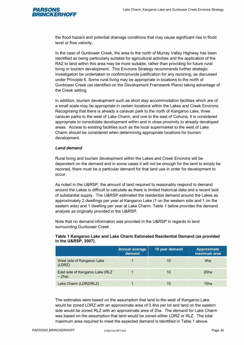
Lake Charm, Kangaroo Lake and Gunbower Creek Environs Strategy
PARSONS BRINCKERHOFF 2189212A-RPT-004 Page 34
the flood hazard and potential drainage conditions that may cause significant rise in floodlevel or flow velocity.
In the case of Gunbower Creek, the area to the north of Murray Valley Highway has beenidentified as being particularly suitable for agricultural activities and the application of theRAZ to land within this area may be more suitable, rather than providing for future ruralliving or tourism development. This Environs Strategy recommends further strategicinvestigation be undertaken to confirm/provide justification for any rezoning, as discussedunder Principle 6. Some rural living may be appropriate in locations to the north ofGunbower Creek (as identified on the Development Framework Plans) taking advantage ofthe Creek setting.
In addition, tourism development such as short stay accommodation facilities which are ofa small scale may be appropriate in certain locations within the Lakes and Creek Environs.Recognising that there is already a caravan park to the north of Kangaroo Lake, threecaravan parks to the west of Lake Charm, and one to the east of Cohuna, it is consideredappropriate to consolidate development within and in close proximity to already developedareas. Access to existing facilities such as the local supermarket to the west of LakeCharm should be considered when determining appropriate locations for tourismdevelopment.
Land demand
Rural living and tourism development within the Lakes and Creek Environs will bedependent on the demand and in some cases it will not be enough for the land to simply berezoned, there must be a particular demand for that land use in order for development tooccur.
As noted in the U&RSP, the amount of land required to reasonably respond to demandaround the Lakes is difficult to calculate as there is limited historical data and a recent lackof substantial supply. The U&RSP estimated the residential demand around the Lakes asapproximately 2 dwellings per year at Kangaroo Lake (1 on the western side and 1 on theeastern side) and 1 dwelling per year at Lake Charm. Table 1 below provides the demandanalysis as originally provided in the U&RSP.
Note that no demand information was provided in the U&RSP in regards to landsurrounding Gunbower Creek
Table 1 Kangaroo Lake and Lake Charm Estimated Residential Demand (as providedin the U&RSP, 2007).
Annual averagedemand
10 year demand Approximatemaximum area
West side of Kangaroo Lake(LDRZ)
1 10 4ha
East side of Kangaroo Lake (RLZ– 2ha)
1 10 20ha
Lake Charm (LDRZ/RLZ) 1 10 15ha
The estimates were based on the assumption that land to the west of Kangaroo Lakewould be zoned LDRZ with an approximate area of 0.4ha per lot and land on the easternside would be zoned RLZ with an approximate area of 2ha. The demand for Lake Charmwas based on the assumption that land would be zoned either LDRZ or RLZ. The totalmaximum area required to meet the expected demand is identified in Table 1 above.

Lake Charm, Kangaroo Lake and Gunbower Creek Environs Strategy
PARSONS BRINCKERHOFF 2189212A-RPT-004 Page 35
Since this time there has been a total of:
� 6 new dwellings approved by Council adjacent to Kangaroo Lake, located on thewestern side of Kangaroo Lake.
� 3 new dwellings approved by Council adjacent to Lake Charm.
All dwellings were constructed on existing lots and no new subdivisions have beenapproved during this time. It is also noted that no new rezoning has occurred, which mayaffect the demand analysis.
What this means is that since the analysis provided in 2007, the demand for new dwellingshas been approximately half that which was originally predicted in the U&RSP. Withoutany substantial trend data it is difficult to predict what the future demand will be, however,taking into account the recent approvals data, it is considered that the future long termdemand (ie, the next 15 years) will be less than what was originally predicted.
Using the current statistics the future residential demand at Kangaroo Lake and LakeCharm is outlined in Table 2 below.
Table 2 Kangaroo Lake and Lake Charm Estimated Residential Demand (based onrecent statistics)
Demand over a 2yearly period
10 year demand Approximatemaximum area ofland required incurrent zoning
West side of KangarooLake (FZ)
1 5 200ha
East side of KangarooLake (FZ)
1 5 200ha
Lake Charm (FZ) 1 5 200ha
The demand analysis in Table 2 is based on historical data and assumes land will remainin the FZ. As there is currently no land zoned within the LDRZ or RLZ, it is difficult topredict what the future demand would be for these types of zoned land at these locations. Itis considered that that the demand would likely be different based on different zonings. It istherefore recommended that prior to any rezoning applications being approved that acomprehensive supply and demand analysis is completed by the proponent based onsimilar developments at similar locations. The actual development uptake will depend on anumber of factors such as property/land prices, lot sizes, utility provision and populationmigration trends. All these factors should be considered by both the Council and theproponent prior to releasing land for future rezoning.
The U&RSP estimated that 20 lots (0-2ha) were vacant in 2006. Since this time 9 lotshave been built on leaving 11 vacant lots, with no more lots created. Using the demandestimate in Table 2 and assuming that no subdivision is undertaken, this only provides a 7-8 year supply. Therefore, in order to meet future demands over the next 15 years (1dwelling per 2 years) an additional 8 lots are required at Kangaroo Lake and 4 lots at LakeCharm.
While this Environs Strategy does not specifically recommend rezoning of lots, it doesenvisage future rezoning of land initiated by proponents, assuming the subdivision ordevelopment proposal meets the Principles of this Strategy. Table 3 below identifies the

Lake Charm, Kangaroo Lake and Gunbower Creek Environs Strategy
PARSONS BRINCKERHOFF 2189212A-RPT-004 Page 36
extent of land included within the ‘Potential Development Areas’ on the DevelopmentFramework Plans.
Table 3 Extent of land included within the ‘Potential Development Areas’ (refer Appendix F)
Area Extent of land
Lake Charm 168.64 ha
An additional 111.93ha of land is provided in thearea identified as ‘areas of poor drainage/subjectto development potential’.
Kangaroo Lake 303.18 ha
Gunbower Creek 168.64 haThis Strategy seeks to provide a flexible approach whereby landholders are provided withthe opportunity to develop or subdivide their land if the Principles of this Strategy can bemet and where the demand is sufficient.
As noted above, a demand analysis will need to be completed as part of any PlanningScheme Amendment process (to rezone land) to demonstrate the feasibility of theproposal. It is in the interests of the proponent to complete this analysis to reduce the levelof risk before proceeding with any form of development. For any rezoning proposalsproponents will need to demonstrate, among other things:
� What zone(s) to use
� What lot sizes would be appropriate for the development
� What markets are being catered to (e.g. retirement, holiday house, permanent living)
� Justification in terms of demand/supply.
In situations where supply exceeds demand, then there will be significant financial burdenson the developer. This Strategy seeks to avoid such situations, ensuring the efficient useof land in a manner which meets market demands.
Figure 5.8 Existing development surrounding Kangaroo Lake

Lake Charm, Kangaroo Lake and Gunbower Creek Environs Strategy
PARSONS BRINCKERHOFF 2189212A-RPT-004 Page 37
Lot sizes and sequencing
Appropriate lot sizes will be determined by the various assessments as required by thisStrategy (see Principles 2, 5 and 6). It is anticipated that over time a range of lot sizes willbe provided within the Lakes and Creek Environs, catering for different peoples’ needs. Asa general guide residential lots within the LDRZ should be approximately 1-2ha and lotswithin the RLZ should be over 2ha. However, as noted in Section 5.2.5, the size of eachallotment will be dependent upon, among other things, any buffer requirements, the landcapability and/or soil suitability and the lands capacity to accommodate onsite wastedisposal. In addition, the scale or density of development should be reflective of theexisting landscape/built form around the Lakes/Creek in the Shire. It is not appropriate forthis Strategy to identify lot sizes, prior to further detailed assessments being undertaken, asthis would not be based on any substantial evidence. Such an approach would also limitflexibility in providing for a range of lot sizes. The Planning Scheme can also provide for arange of lot sizes specified in the schedules to the LDRZ or the RLZ.
In regards to sequencing, this Environs Strategy and associated Development FrameworkPlans do not recommend the priority or sequencing in which areas should be developedwithin the ‘Potential Development Areas’. Sequencing will ultimately be driven by themarket and landowners willingness to develop. The demand analysis completed byproponents will also help justify sequencing. Notwithstanding this, when determining thesuitability of developing certain areas, priority should be given to areas which meet theprinciples of this Strategy (ie, areas with good views of the water, good road access to thehighway and limited constraints).
Location of development
This Strategy seeks to encourage development, firstly within the ‘Potential DevelopmentAreas’, However development proposals may be considered suitable where they candemonstrate that:
� There is a demand for the proposed type of development located outside of the‘Potential Development Areas’;
� The necessary utilities and services can be provided;
� The costs of the provision of relevant infrastructure can be met by the developer; and
� The development will not result in conflicts between existing agricultural uses.
This is reflected in Principle 4.
Principle 4:
Where it is proposed to locate development outside of the “Potential DevelopmentAreas” on the Development Framework Plans, it must be demonstrated that:
(i) There is a demand for the development
(ii) Infrastructural demands of the development can be provided for and met in acost effective manner
(iii) The development will not jeopardise the existing or future use of suitableagricultural land.

Lake Charm, Kangaroo Lake and Gunbower Creek Environs Strategy
PARSONS BRINCKERHOFF 2189212A-RPT-004 Page 38
(iv) The development proposal must meet all other development principles underthis Environs Strategy.
5.2.4 Land and environmental capability
Principle 5:
Development should be avoided in areas known to be:
� Subject to flooding or inundation
� Environmentally sensitive or have significant environmental values
� Culturally or historically significant or have significant values
� Subject to wildfire risks
There are a number of constraints which limit the development potential of the Lakes andCreek Environs. These include factors such as: flooding, bushfire risk, infrastructuralrequirements, ecological and cultural heritage values, and agricultural land uses. The mapsincluded within Appendix E show some of these constraints. 8 Development within theseconstraint areas should be avoided to reduce potential risks to life and property, to avoidadverse impacts on the natural and physical features of the area and to protect theresources upon which the agricultural industry relies. Any development within these areaswill need to demonstrate the extent of the potential impacts and the degree to whichmitigation measures can reduce these impacts.
Agricultural activities
Furthermore, as noted in Section 4.5, agricultural activities are important contributors to thelocal economy and these land uses will need to be protected, and where possibleopportunities for new or increased agricultural uses should be encouraged. Landsurrounding Gunbower Creek in particular, an area to the east of Cohuna and part of theGunbower study area, has been identified as being potentially suitable for agriculturalactivities9. Extensive development within this area would be inconsistent with theobjectives of the SPPF, the MSS and the LFFP, all of which seek to protect agriculturallyproductive land. There may however, be an opportunity to provide some small scale ruralliving development in certain locations where it can be demonstrated that the agriculturalpotential will not be compromised. In addition, agricultural opportunities have beenidentified beyond the immediate Lakes environments, particularly on the western side ofKangaroo Lake. Again, any future development must demonstrate that it will notcompromise the agricultural values or potential use of productive agricultural land.
8 Note: agricultural land use and bush fire risk have not been mapped. This is because there has been nocomprehensive study on the agricultural capability of land within the Lakes and Creek Environs. This issuggested as an Action in Section 6.3. Also, while the Planning Scheme maps do not identify fire risks in theseareas, consultation with local authorities has identified potential risks in the marshes and significant vegetationareas to the south-west of Lake Charm and Kangaroo Lake.
9 RMCG (2011) Analysis and Mapping of Irrigated Land.

Lake Charm, Kangaroo Lake and Gunbower Creek Environs Strategy
PARSONS BRINCKERHOFF 2189212A-RPT-004 Page 39
As such, this Strategy seeks to achieve the following principle:
Principle 6:
Avoid development of land which has been identified as being particularly suitablefor agricultural land uses. Any development within the Lakes and Creek environs willneed to demonstrate that it will not compromise existing agricultural land uses onthe subject site or on surroundings sites.
5.2.5 Utilities, infrastructure, services and access
Principle 7:
Wastewater infrastructure and utility requirements of future development must beadequately met and provided for in a cost effective manner.
There are a number of infrastructural and service constraints which limit the developmentpotential of sites within the Lakes and Creek Environs. This includes wastewatermanagement, stormwater management, transport and road access, power and potablewater reticulation.
The management of wastewater is of particular importance in the Lakes and CreekEnvirons and any future development will be dependent on the ability of the land toadequately dispose of wastewater. Each development will need to demonstrate how thewastewater will be managed so that there will be no potential runoff or impacts on thequality of nearby waterways, ensuring that the ecological values and recreational valuesare maintained and that there are no adverse impacts on irrigation schemes.
The size of allotments and the buffer requirements will be dependent upon the soil andland capability to accommodate this waste. Comprehensive assessments will need to beprovided with any future rezoning or development proposal prior to determining if theproposal is feasible.
Figure 5.9 Lake Charm Pump Station

Lake Charm, Kangaroo Lake and Gunbower Creek Environs Strategy
PARSONS BRINCKERHOFF 2189212A-RPT-004 Page 40
In addition, any future development will need to demonstrate how the necessary utilitiesand services can be provided and how the costs of the provision can be met. Thisassessment will also need to consider the impacts of the provision of services andinfrastructure (ie, traffic impacts, stormwater runoff etc). The costs of infrastructureprovision can be provided for either through direct contributions (ie, through planningpermit conditions) or through a Development Contributions Process (as outlined further inSection 6.1.2.
5.2.6 Recreational values and public access
Principle 8:
Developments must provide attractive, safe and functional open spaces thatintegrate with existing developments and enhance the recreational opportunities ofthe existing waterbodies.
The environmental and heritage values of the Lakes and Creek play a significant role inestablishing the character of the area and they provide for a number of recreationalactivities. There is an opportunity to enhance these areas by making them more attractiveand encouraging further residential and tourist development, better integrating them withexisting land uses. A pedestrian and cycling path along the Lake and Creek edge is oneexample of how recreational activities can be enhanced. All future development shouldcontribute to the recreational values and provide opportunities for additional activities.
The community has identified the need to clearly define the roles and responsibilities forthe management of land immediately surrounding the Lakes and Creek. This Strategysupports this view and seeks to achieve the following principle:
Principle 9:The management of the Lakes and Creek Environs needs to be undertaken in acoordinated manner with Council, the local community, key stakeholders andvisitors working collaboratively to protect the natural and physical features and tomaximise the long term environmental, economic and social benefits of these areas.

Lake Charm, Kangaroo Lake and Gunbower Creek Environs Strategy
PARSONS BRINCKERHOFF 2189212A-RPT-004 Page 41
6. Recommendations, Implementation &Monitoring
6.1 Implementation Actions
This section identifies implementation provisions and key Planning Scheme amendmentsor supporting strategic work, necessary to attain the principles and directions identified inthis Environs Strategy including:
� Introduction of planning policy
� Further strategic work required to assess the suitability of sites
� Further liaison with key authorities and infrastructure providers
� Other actions critical to attaining key principles and directions.
6.1.1 Planning Scheme Amendments
The primary planning instrument or statutory process to implement this Environs Strategyis through the Gannawarra Planning Scheme. This will ensure that any future developmentand/or subdivision proposals meet the long term vision and that the principles outlined inthis Strategy have a statutory standing. The specific Planning Scheme amendmentchanges to implement this Environs Strategy are detailed within Table 1 below.
6.1.2 Developer contributions
It is anticipated that new rural-residential, rural-living and tourist development will occurover time within the Lakes and Creek Environs. There is an opportunity to seek developercontributions in the form of payments or in-kind works for civic infrastructure improvements.This may include roads, bicycle or pedestrian paths, lighting, stormwater infrastructure andopen space and community facilities. There are principally two methods whereby Councilmay recoup costs from landholders to offset the costs of urban development andassociated infrastructure provision:
� Developer Contributions Plan (DCP) – A DCP sets out the levies required for newdevelopments to fund planned infrastructure investments. A DCP is binding to boththe Council and landholders (developers) and monies must be spent by Council onitems for which the money was collected for. The DCP sets out a framework of whatprojects are required, the costs of each project, when it will be delivered and what isCouncil’s contribution and the landholder/developer contribution.
The DCP in practice is used to charge new development for its share of infrastructurecost. On this basis, existing development is not charged through this funding tool butis used in the calculation of charges. In most cases existing development will benefitfrom the infrastructure project. A DCP also has the advantage of providing for fundinginfrastructure which may not be directly part of the development. For example where adevelopment affects land outside of the immediate subdivision area (ie, road orintersection upgrades), Council can justify the request for the developer to contribute

Lake Charm, Kangaroo Lake and Gunbower Creek Environs Strategy
PARSONS BRINCKERHOFF 2189212A-RPT-004 Page 42
to pay for such an upgrade when a nexus is proven between the proposeddevelopment and the required improvement.
� Section 173 Agreements – Council may enter into individual Section 173 Agreementsunder the Planning and Environment Act 1987 instead of using a DCP to recoup costsfor infrastructure provision. Section 173 Agreements appear as conditions onsubdivision or development permits and are registered on the land title.
Whilst a DCP is the preferred mechanism for securing contributions, this option is bothcostly and time consuming. In addition Council would need a clear understanding of howthe land is to be used and developed to complete a DCP. The Environs Strategy identifiesarea of land for potential development however is not specific about how the land will beused and does not propose to rezone land. Council therefore has an opportunity toconsider necessary contributions, associated upgrades, service connections and costs atthe time a rezoning application is made. There is also greater opportunity to enter into aSection 173 Agreement with the landowner at the time of rezoning than at the PlanningPermit stage.
It is understood that Council is wishing to pursue the development of a DCP for the entiremunicipality once the Minister for Planning releases a standard model. At this time furtherconsideration may be given to the Lakes and Creek Environs.
6.2 Monitoring and review
In order to ensure the effectiveness and future relevance of this Environs Strategy it isnecessary for regular monitoring to be undertaken to assess its performance against theoverall vision and to determine progress against the action identified in the implementationtable.
This Environs Strategy has been prepared with a 20 year horizon, while acknowledgingthat changes in demand are likely to occur and that the Strategy must be responsive andadaptable over time. Therefore, it is necessary that several forms of monitoring are carriedout during the implementation of this Plan. This includes:
� Review and updating of the Environs Strategy initially after 3 years time as themajority of the actions identified in the implementation table have an immediate toshort-term timeframe. The review should include an examination of trends and theuptake of land for development opportunities. Following this, a review should typicallyoccur once every 5 years.
� Review of the planning scheme policies, overlays and zones to ensure that thedesired outcomes of the Environs Strategy are being successfully implemented. Thiswill include an assessment of the recent planning applications and approvals,discussions with Council’s Senior Statutory Planners and include a review of VictorianCivil and Administrative Tribunal (VCAT) decisions.
� Community survey to assist with identify new/emerging trends that may be specific tocommunity needs/values.
Outcomes of the review should be used to review/update the Strategy as required.

Lake Charm, Kangaroo Lake and Gunbower Creek Environs Strategy
PARSONS BRINCKERHOFF 2189212A-RPT-004 Page 43
6.3 Implementation table
The actions required to implement this Environs Strategy are detailed in the table below, with timing, responsibilities and priorities.
Timeframes
Immediate within <1 year
Short-term within 1-5 years
Medium term within 5 -10 years
Long-term within 10+ years
Table 6.1 Implementation Table
Action Statutory Instrument Non-Statutory Instrument Commencementdate
Duration Party/organisation(s)responsible
1. Introduce a MSS reference (or clause) and a LocalPolicy into the Gannawarra Planning Scheme in whichthe Environs Strategy is referenced.The local planning policy should require subdivisionand development applications to:
� Demonstrate response to the principles of theEnvirons Strategy
� Demonstrate compliance with the DevelopmentFramework Plans.
� Provide land capability assessments that assess thesuitability of the land for development and identifies(through a site analysis) the minimum lot sizes foradequate on-site wastewater management.
� Provide site specific environmental investigationswhich include an assessment of the proposal andthe potential impacts in relation to: flooding;
Planning SchemeAmendment
Lake Charm, KangarooLake and Gunbower CreekEnvirons Strategy
Immediate 12-18 months � Gannawarra Shire Council,DPCD

Lake Charm, Kangaroo Lake and Gunbower Creek Environs Strategy
PARSONS BRINCKERHOFF 2189212A-RPT-004 Page 44
Action Statutory Instrument Non-Statutory Instrument Commencementdate
Duration Party/organisation(s)responsible
environmental values, cultural heritage values,wildfire risks.
� Provide agricultural land capability assessmentsthat demonstrate that there will be no adverseimpacts on agriculturally productive land.
� Provide open space areas as part of any substantialdevelopments/subdivisions.
2. Prepare a set of Design Principles or an UrbanDesign Framework (UDF) to guide new developments.This should include:
� Appropriate building location (setbacks)
� Appropriate design of buildings (form and colours)
� Landscape treatments
A Planning Scheme Amendment should be prepared toincorporate reference to the design principles or UDF.This may include the introduction of policy to the MSSor an Overlay into the Planning Scheme.
Planning SchemeAmendment
Design Principles or UrbanDesign Framework
Short – MediumTerm
12-18 months(design principles orUDF)PSA following
� Gannawarra Shire Council
3. Developers must investigate the potential trafficaccess issues as a result of any future subdivision and/or development proposals. Engage with VicRoads andthe local Council to identify and demonstrate impacts.Provide details to Council as part of anysubdivision/development proposal.
Nil Nil Immediate Ongoing � Developers, utilityoperators, serviceproviders
4. Developers must investigate utility requirements forfuture subdivisions/and or development proposalsincluding provision of electricity, potable water, gas,telecommunications. Engage with relevant utilityproviders as part of this process.Provide details to Council as part of anysubdivision/development proposal
Nil Nil Immediate Ongoing � Developers, utilityoperators, serviceproviders
5. Developers must investigate wastewatermanagement and identify a suitable option for thedisposal of wastewater from the site. As part of process
Nil Nil Immediate Ongoing � Developers, utilityoperators, serviceproviders

Lake Charm, Kangaroo Lake and Gunbower Creek Environs Strategy
PARSONS BRINCKERHOFF 2189212A-RPT-004 Page 45
Action Statutory Instrument Non-Statutory Instrument Commencementdate
Duration Party/organisation(s)responsible
discussions should be undertaken with GoulburnMurray Water.Provide details to Council as part of thesubdivision/development proposal.
6. Develop a Lakes and Creek Management Plan whichclearly articulates who is responsible formaintaining/enhancing the Lakes and Creek environsand the timeframes for doing so.The management strategy will need to include howpublic/private land surrounding the Lakes and Creek willbe managed (ie, is it feasible to provide public accessaround all the Lakes/along the whole Creek corridor).
Nil Lakes and CreekManagement Plan
Short-term 12-18 months � Gannawarra Shire Councilworking with the localcommunity, key authoritiesand community groups


7. ReferencesThe following documents and strategies were used in the preparation of this Strategy:
� RMCG (2007) Domestic Wastewater Management Plan (DWMP) Shire of Gannawarra
� Parsons Brinckerhoff (2007) Gannawarra Urban and Rural Strategy Plan. GannawarraShire Council
� SKM (2010) Hydrological Assessment of Kangaroo Lake Domestic Septic Tank andGroundwater Impacts (2010)
� Gannawarra Shire Council (April 2011) Waterfront Development Guidelines: Guidelinesfor eligibility to apply for rezoning to allow subdivision to create nodal rural residentialsettlements close to water frontage.
� Gannawarra Shire Council (October 2010) Gannawarra Future Scan – Ganna 0503
� Gannawara Shire Council (December 2010) Gannawarra 2025. Taking up the challenge
� Gannawarra Shire Council (2009-2013) Council Plan and Strategic Resource Plan
� Gannawarra Shire Council (2010) Review of the Gannawarra Planning Scheme
� RNCG (2010) Impacts of Sales of Permanent Water Entitlements and Land UsePlanning Options for New Dryland Gannawarra Shire
� Department of Planning and Community Development (2012) Practice Note 37. RuralResidential Development
� Mark Reilly Landscape Architects (2002) Kangaroo Lake Management Plan.Gannawarra Shire Council
� RMCG (2011) Analysis and Mapping of Irrigated Land. Final Report
� Gannawarra Shire Planning Scheme