lake county/city area planning council
TRANSCRIPT

LAKE COUNTY/CITY AREA PLANNING COUNCIL Lisa Davey-Bates, Executive Director 367 North State Street, Ukiah, CA 95482 www.lakeapc.org Administration: Suite 204 ~ 707-234-3314 Planning: Suite 206 ~ 707-263-7799
TECHNICAL ADVISORY COMMITTEE (TAC) MEETING AGENDA
DATE: Thursday, September 15, 2016 TIME: 9 a.m. PLACE: City of Lakeport Caltrans-District 1 Small Conference Room Teleconference 225 Park Street 1656 Union Street Lakeport, California Eureka, California
Teleconference Dial-In #: 866-576-7975 Passcode: 961240
1. Call to order
2. Approval of May 19, 2016 Minutes 3. Active Transportation Plan Update (Sookne)
4. Announcements and Reports
a. Lake APC i. Active Transportation Program Update (Dow) ii. Roundabout at State Routes 20 & 53 (Davey-Bates/Carstensen) iii. Miscellaneous
b. Lake Transit Authority i. Transit Hub Location Plan Update (Davey-Bates) ii. NEMT Update (Wall/Davey-Bates) iii. Miscellaneous
c. Federal & State Grant Status Reports i. HSIP Cycle 8 Update (Sookne) ii. FTA Rides to Wellness Grant (Davey-Bates) iii. Sustainable Planning Grant – Call for Projects (Sookne) iv. Other Grant Updates (All)
d. Caltrans i. Lake County Projects Update ii Other Updates
e. Miscellaneous i. Legislative Update – Prop 53 and Frazier/Beall Bill
5. Information Packet a. 5/21/16 Lake APC Minutes b. 1st Amended 2016/17 Overall Work Program
6. Public input on any item under the jurisdiction of this agency, but which is not otherwise on the above agenda
7. Next Proposed Meeting – October 20, 2016

Lake TAC Meeting September 15, 2016 – Page Two
8. Adjourn meeting
Public Expression - The TAC welcomes participation in TAC meetings. Comments will be limited for items not on the agenda to three minutes per person, and not more than 10 minutes per subject, so that everyone may be heard. This time is limited to matters under TAC jurisdiction which have not already been considered by the TAC. Americans with Disabilities Act (ADA) Requests - To request disability-related modifications or accommodations for accessible locations or meeting materials in alternative formats (as allowed under Section 12132 of the ADA) please contact the Lake APC office at 707-263-7799 at least 72 hours prior to the meeting. Posted: September 8, 2016 List of Attachments: Agenda Item #2 – (Draft) 5/19/16 Lake TAC Minutes Agenda Item #3 – Draft ATP Plan Agenda Item #4ai – Staff Report Agenda Item #4aii – 20/53 Info Agenda Item #4ciii – Grant Application Guide Agenda Item #4di –Caltrans Projects Update for Lake County Agenda Item #4ei – Frasier-Beall Summary Agenda Item #5 – Information Packet
a. 5/11/16 Lake APC Minutes b. 1st Amended 2016/17 OWP

LAKE COUNTY/CITY AREA PLANNING COUNCIL Lisa Davey-Bates, Executive Director 367 North State Street, Ukiah, CA 95482
www.lakeapc.org Administration: Suite 204 ~ 707-234-3314 Planning: Suite 206 ~ 707-263-7799
Lake TAC Meeting: 9/15/16 Agenda Item: #2
TECHNICAL ADVISORY COMMITTEE MEETING Draft Meeting Minutes
Thursday May 19, 2016 9 a.m.
City of Lakeport Small Conference Room
225 Park Street Lakeport, California
Present Todd Mansell, Department of Public Works, County of Lake
Kevin Ingram, Community Development Department, City of Lakeport Doug Grider, Public Works Superintendent, City of Lakeport
Doug Herren, Public Works Director, City of Clearlake Dave Carstensen, Caltrans District 1 (by telephone)
Absent Lisa Davey-Bates, Executive Director, Lake County/City Area Planning Council
Phil Dow, Lake Area Planning Council Mark Wall, General Manager, Lake Transit Authority
Greg Folsom, City Manager, City of Clearlake Mireya Turner, Assistant Planner, County of Lake
Hector Paredes, California Highway Patrol
Also Present James Sookne, Transportation Planning, Lake County/City Area Planning Council
Jesse Robertson, Transportation Planning, Lake County/City Area Planning Council Alexis Pedrotti, Lake County/City Area Planning Council Nephele Barrett, Lake County/City Area Planning Council
1. Call to orderThe meeting was called to order at 9:08 a.m.
2. Approval of April 21, 2016 Lake APC TAC MinutesKevin Ingram made a motion to approve the April 21, 2016 minutes with corrections. The motion wasseconded by Todd Mansell and carried unanimously.
3. Discussion and Recommended Approval of the Draft 2016-17 OWPAlexis Pedrotti reported that the Draft 2016-17 OWP was sent to Caltrans for review andhas come back with comments. It is approximately $412,000, not including any carry-overprojects that will be incorporated in an August amendment. The new projects in this OWPare the Speed Zone Studies – County of Lake, the Countywide Sign Inventory Project, andthe Regional Transportation Plan Update. Other than that, everything is the same as theprevious OWP.

Doug Herren asked if there was any additional money in the 16-17 OWP for GIS Training. Alexis informed him that there isn’t, however, the City of Clearlake has approximately $3,000 in the current OWP for training. This money can be carried over to the 16-17 OWP if necessary, and Alexis advised putting it in the Training Work Element to allow for flexibility rather than forcing the money to be spent strictly on GIS training. Nephele Barrett asked for clarification on Work Element 612 – Countywide Technology Support Services. Alexis stated that this work element used to be only for GIS support but was changed to allow for additional types of software, etc. Kevin Ingram asked if there was any training money available in the 16-17 OWP. Alexis stated that there isn’t any money available in the Training work element unless the money from the current OWP is carried over. Alexis pointed out that there is no money currently set aside in the 16-17 OWP to pay for local agency time spent on the Regional Transportation Plan Update. She is hopeful that there will be some carry over funds available for the local agency time. There were no additional questions or comments on the Draft 2016-17 OWP. Kevin Ingram made a motion to recommend approval the 2016-17 OWP. The motion was seconded by Todd Mansell and carried unanimously.
4. Active Transportation Plan Discussion Jesse Robertson reported that there has been some input on the mapping. The delayed
completion of the maps has impacted the ability to broadly disseminate the draft plan for review and comments. As a result, it is unlikely that the plan will be adopted at the June APC meeting.
Due to a lack of available sidewalk data, one of the recommendations in the plan is to apply for a Caltrans Affordable Housing Sustainable Communities grant to do a comprehensive sidewalk survey throughout Lake County. Dave Carstensen questioned why the segment of sidewalk from Shaul Road to Butler Avenue in Clearlake Oaks is included as a proposed project since it is within the segment from Keys Boulevard to Foothill Boulevard. Dave stated that because neither segment specifies which side of the road the sidewalk is to be constructed, the larger segment is all that would be needed to apply for future grants. It was decided that the segment between Shaul Road and Butler Avenue would be deleted from the table. Alexis also questioned the New Alignment from State Route 20 to 1st Street because there is no viable path for this segment to be constructed. Since this section of sidewalk would have to be constructed across private property, it will also be deleted from table. Alexis asked if she should leave the existing and proposed sidewalks unmapped since she doesn’t know which side of the road they should be on. The consensus was to leave them unmapped until a complete sidewalk inventory is done. Nephele stated that APC staff would like to bring the draft plan back to the TAC in June for a recommendation to the APC for action in August. The August APC Board meeting will also serve as a public hearing for the plan. The draft will need to go out for public review

between the May and June TAC meetings. This will be done by posting it on the APC website as well as distributing it to the contact list that was developed during the initial public participation process. Final comments from the local agencies are due to Alexis by May 27th. One last issue was the use of the term “financially constrained”. The local agencies didn’t like that term and decided to use the terms “funded” and “unfunded”. If a project listed in the plan needs to be changed from “funded” to “unfunded” or vice versa, all that would be needed is an amendment to the plan which could be done at any APC meeting.
5. Announcements and Reports
a. Lake APC i. Unmet Transit Needs Report
Nephele Barrett reported the changes to the list of unmet needs since the TAC meeting in February. These included additional identified needs, LTA’s analysis of each need, and the finding that was adopted by the APC on May 11, 2016. There were no items that were considered unmet needs that were reasonable to meet. Some were considered unmet needs but not reasonable to meet and some were not considered unmet needs based on the adopted definition. One other change to the list that the TAC saw affected the section at the end regarding other concerns that were identified. Per Mark Wall’s request, those were completely separated out in another list. TDA dictates the unmet needs process, and it is specific to transit service needs, and these other needs weren’t transit service related. They are shown on the last page so that the APC and the public are aware of them and there is a response from LTA for each one.
ii. Active Transportation Program Update
Jesse Robertson is working with the City of Lakeport on their Hartley ATP application, and APC staff is awaiting the City of Clearlake’s decision on whether to pursue an ATP application. Doug Herren reported that his City Council is considering reallocating the money that was to be used for the ATP project to a different project in the City. If this happens, the City of Clearlake will not submit an ATP application for Cycle 3.
iii. Tour of the Proposed Roundabout at State Routes 20 & 53
Nephele reported that there were 2 options for a roundabout discussed on the tour. One was a 3-legged roundabout and the other was a 4-legged roundabout. Both cost roughly the same amount of money. The 3-legged option would have a frontage road along the north side and a bypass lane for thru-traffic traveling west on State Route 20. The 4-legged roundabout would force all traffic through the roundabout.
iv. Miscellaneous None.
b. Lake Transit Authority
i. Transit Hub Location Plan Update Jesse Robertson announced that there was a charrette event on May 12. The main discussion at the event was about security around the transit hub. Some people in attendance expressed concern that the people who loiter around the existing transit hub would move to the new location. Mark Wall intends to mitigate that problem with additional security measures. The existing contract for the design of the hub may be extended to look at safety and security in more detail.
ii. NEMT Update
There was a meeting during the 3rd week of May (prior to the TAC meeting) involving representatives from the hospitals, transit, and the SSTAC to discuss how they are going to move forward with NEMT and look at what kind of partnerships can be formed with medical providers. Jesse Robertson spoke with Lisa Davey-Bates and Mark Wall, both of whom attended the meeting, and reported that there was unanimous support from Sutter Lakeside Hospital, Saint Helena Clearlake, the dialysis clinics, and other care providers. All of the attendees seemed to be willing to look into a brokerage system and participate in the CTSA.
iii. Miscellaneous
None.
c. Federal & State Grant Status Reports i. HSIP Cycle 8 Call for Projects
Applications are due August 12th. The City of Lakeport may pursue a HSIP project along Martin Street.
ii. FTA Rides to Wellness Grant Application Jesse Robertson is working on this grant with Mark Wall and Karl Parker. Caltrans is going to submit the grant on behalf of the APC. This application will be 1 of 3 that can be submitted by Caltrans statewide.
iii. Other Grant Updates None.
d. Caltrans
i. Lake County Project Updates Everyone liked the map of the projects. Dave Carstensen will likely update the list prior to the June TAC meeting. The two projects listed under “PSRs Complete & Not Yet Programmed (for Design)” will be moved to “Projects Programmed (in Design)” because they made it into the 2016 SHOPP.
ii. Other Updates None.

e. Miscellaneous i. Senate Bill (SB) 743
Nephele explained that the intent of SB 743 was to help streamline the CEQA process. Level of Service is no longer a metric that can be used to determine level of impact for CEQA. It looks like Vehicle Miles Traveled (VMT) will be the new metric. Mendocino County local agencies are interested in having training on SB 743 and how it will affect them. Local agencies in Lake County said they would also be interested in training. APC staff has spoken to Fehr and Peers regarding a joint training with Mendocino County that would be held in the fall.
6. Information Packet
7. Public input on any item under the jurisdiction of this agency, but which is not otherwise on the above agenda.
None. 8. Next Proposed Meeting – June 16, 2016
9. Adjourn Meeting
Meeting adjourned at 10:34 a.m.
Respectfully Submitted, (Draft) James Sookne Lake APC Transportation Planning

LAKE COUNTY/CITY AREA PLANNING COUNCIL TAC STAFF REPORT
TITLE: Active Transportation Plan Update DATE PREPARED: September 8, 2016MEETING DATE: September 15, 2016
SUBMITTED BY: James Sookne, Project Manager
BACKGROUND:
In February 2015, the Lake APC Board approved the staff recommendation to allocate $25,663 to begin work on the Lake County Active Transportation Plan. An additional $51,858 were allocated to this project, of which $40,000 were competitive RPA funds awarded by Caltrans in March 2015.
The purpose of this plan is to identify and prioritize non-motorized and transit station/stop improvement projects and conduct public outreach to strengthen future grant applications for Active Transportation projects within the region. An Active Transportation Advisory Committee (ATAC) was established for this project that includes members from the following agencies:
• County of Lake Department of Public Works• County of Lake Public Health Department• County of Lake Planning Department• City of Lakeport• City of Clearlake• Lake Transit Authority• Caltrans
Public outreach was conducted during the second half of 2015 by the consulting firm Redwood Community Action Agency. The final report was completed in December 2015 and was distributed to the TAC at the January 2016 meeting. Following the public outreach, APC staff developed an administrative draft Active Transportation plan to be distributed the ATAC for comments.
The draft plan is in nearly complete. The next step is for APC staff to meet with the local agencies to refine and prioritize the lists of projects within the Active Transportation plan and gather any further comments on the narrative. APC staff would like to receive all input from local agencies so that the final draft can be prepared by early October.
ACTION REQUIRED: None.
ALTERNATIVES: None identified.
RECOMMENDATION: None. This is for your information only.
Lake TAC Meeting: 9/15/16 Agenda Item: #3

Draft Active Transportation Plan
for Lake County
Prepared by:
Lake Area Planning Council
367 North State St., Suite 204
Ukiah, CA 95482
October 2016
This document is a product of Work Element 604 of the Lake County/City Area Planning Council’s Overall Work Program for FY 2015/2016

Lake Area Planning Council Board of Directors
Martin Scheel, Chair Mayor, City of Lakeport
Jeff Smith Supervisor, County of Lake
Jim Comstock Supervisor, County of Lake
Russell Perdock Clearlake City Council Member
Gina Fortino-Dickson Clearlake City Council Member
Stacey Mattina Lakeport City Council Member
Chuck Leonard Member at Large
Rachelle Damiata Member at Large
Anthony Farrington, Alternate Supervisor, County of Lake
Bruno Sabatier, Alternate Clearlake City Council Member
Marc Spillman, Alternate Lakeport City Council Member
Lake Area Planning Council Staff Lisa Davey-Bates, Executive Director
Phil Dow, Transportation Planning Jesse Robertson, Transportation Planning
Alexis Pedrotti, GIS Maps
Stakeholders
Lars Ewing, Deputy Director, Lake County Public Works Todd Mansell, Lake County Public Works
Dr. Karen Tait, Lake County Public Health Department Audrey Knight, Lake County Planning Department Nathalie Antus, Lake County Planning Department Margaret Silveira, City Manager, City of Lakeport
Kevin Ingram, Community Development Director, City of Lakeport Doug Grider, Public Works Department, City of Lakeport
Greg Folsom, City Manager, City of Clearlake Doug Herren, Public Works Director, City of Clearlake
Bill Clemans, City Engineer, City of Clearlake Rex Jackman, Caltrans, District 1
Dave Carstensen, Caltrans District 1 Lisa Hockaday, Caltrans District 1
Mark Wall, General Manager, Lake Transit Authority

Table of Contents Introduction………………………………………………………………………………………………………………………. Purpose and Need…………………………………………………………………………………………………………………. Regional Overview…………………………………………………………………………………………………………………. Coordination and Consistency with Other Plans……………………………………………………………………. Required Plan Element………………………………………………………………………………………………………….. Setting and Context…………………………………………………………………………………………………………… Background……………………………………………………………………………………………………………………………. Land Use………………………………………………………………………………………………………………………………… Disadvantaged Communities…………………………………………………………………………………………………. Bicycle Infrastructure…………………………………………………………………………………………………………….. Bikeway Classifications………………………………………………………………………………………………………….. Pedestrian Infrastructure………………………………………………………………………………………………………. Transit Linkages…………………………………………………………………………………………………………………….. Safety…………………………………………………………………………………………………………………………………….. Maintenance…………………………………………………………………………………………………………………………. Evaluation and Assessment……………………………………………………………………………………………………. Enforcement………………………………………………………………………………………………………………………….. Education………………………………………………………………………………………………………………………………. Encouragement……………………………………………………………………………………………………………………… Public Health…………………………………………………………………………………………………………………………. Recreational Trails…………………………………………………………………………………………………………………. Wayfinding Signs…………………………………………………………………………………………………………………… Community Outreach………………………………………………………………………………………………………… Goals, Objectives and Policies……………………………………………………………………………………………. Action Plan………………………………………………………………………………………………………………………… City of Lakeport……………………………………………………………………………………………………………………… City of Clearlake…………………………………………………………………………………………………………………….. County of Lake………………………………………………………………………………………………………………………. Bicycle and Pedestrian Facility Maps…………………………………………………………………………………. Funding Sources………………………………………………………………………………………………………………… Implementation………………………………………………………………………………………………………………… Appendices
A. Resolutions of Adoption of the Lake Active Transportation Plan B. Community Involvement C. List of Projects by Jurisdiction D. Weighting Criteria for Project Prioritization

Introduction
Purpose and Need The Lake Area Planning Council has developed this Active Transportation Plan in coordination with the County of Lake, the City of Lakeport, the City of Clearlake and the Lake Transit Authority. With input from community stakeholders and members of the public, the result is a regional vision for improving and integrating the bicycle and pedestrian network. The plan will create baseline eligibility within the region for grant applications under the Active Transportation Program.
This plan is consistent with the California Transportation Commission (CTC) adopted 2015 Active Transportation Program Guidelines and is consistent with Assembly Bill 101 (2013) and Senate Bill 99 (2013), which has a stated intent of increasing the use of active transportation modes. Due to the unavoidable overlap with the non-motorized element of the existing Regional Transportation Plan, the Lake Active Transportation Plan will also to serve as the non-motorized element in future Regional Transportation Plan updates.
Coordination and Consistency with Other Plans The Active Transportation Plan will replace the existing Regional Bikeway Plan, last updated in 2011 and will serve as the non-motorized element of the Regional Transportation Plan. The Active Transportation Plan will be updated every four years, to be kept current with the updates to the Regional Transportation Plan. Other local planning documents that help to define the regional transportation vision and goals are described below.
2010 Lake County Regional Transportation Plan Regional Transportation Plans (RTPs) are 20+ year planning documents for the Regional Transportation Planning Agencies that provide a comprehensive picture of the multi-modal transportation needs and development plan for the respective regions. The RTP for Lake County has historically been updated every five years, but future updates will be updated every four years with input from the public to coincide with the Regional Housing Needs Assessment.
2011 Lake County Regional Transportation Bikeway Plan The Bikeway Plan identifies existing and proposed bicycle facilities in Lake County and the incorporated cities, and includes their collective priorities for implementation. Prior to the arrival of the Active Transportation Program, this document served as a capital improvement program for Bicycle Transportation Account (BTA) funding. It was also used to identify projects for TE, SR2S, and STIP funding. The Active Transportation Program has absorbed and blended the BTA program into a larger non-motorized funding program.
Lake County Safe Routes to School Plan (2009) The Safe Routes to School (SRTS) Plan is a collaborative effort between public school districts and the public agencies responsible for transportation and roadway improvements. Public outreach for the plan was conducted, which contributed to the plan’s conclusions and recommendations. The SRTS plan identifies circulation improvements for pedestrian and bicyclists to improve safety for active transportation around the schools and encourage non-motorized transportation to and from school.
Lakeshore Drive Downtown Corridor Plan (2014) Through community engagement and a design development process, the plan proposes concepts to establish a complete street environment to help revitalize commercial nodes and public parks as a way to draw more tourism and create a more positive experience for visitors to Clearlake. Improvements will aim to preserve and enhance the connection between the community and the lakeshore, including views of the lake and Mount Konocti.
Middletown Community Action Plan (2014) Caltrans and the Lake Area Planning Council collaborated on a Public Partnership Planning grant project to jointly plan for the development of a multi-modal transportation network that addresses the community’s needs for main street livability while continuing to serve regional or interregional travel on the two State highways running through town, State Routes 29 and 175.
Konocti Regional Trails (KRT) Master Plan (2011) The KRT Master Plan is a countywide plan which lays the groundwork for establishing a network of trails, both for recreation and for non-motorized transportation. Some of the goals include: support and inspire healthy lifestyles, foster outdoor recreation and tourism and promote economic development, offer opportunities for learning and environmental stewardship, provide options for alternative modes of transportation, and increase public access in rural parts of the County.
Highway 20 Traffic Calming and Beautification Plan (2006) The Highway 20 corridor plan serves the unincorporated communities of Upper Lake, Nice, Lucerne, and Clearlake Oaks. All but the community of Upper Lake have Highway 20 as their main street. The plan outlines improvement options for making a more pedestrian-friendly atmosphere in the various community downtowns.
Lake County 2030 Regional Blueprint The Lake County Blueprint provides a vision and plan for growth in Lake County through 2030. The preferred “Balanced Growth” scenario emphasizes infill within existing community boundaries, including the redevelopment and revitalization of Lakeshore Drive as described in the Vision Task Force Report and subsequent Design Guidelines.

Lake County General Plan and Area Plans Lake County adopted their current General Plan in 2008. The Transportation and Circulation Element of the General Plan discusses goals and policies. Circulation plans were created for each of the eight Area Plans. The Area Plans vary in age, but the most recent is the Middletown Area Plan, which was adopted in 2010. The Shoreline Communities Area Plan was adopted in 2007 and is one of the more relevant Area Plans. While the Area Plans generally do a good job of addressing non-motorized transportation, only the Middletown Area Plan was adopted after the passage of the Complete Streets Act of 2008. The Lake County General Plan and Area Plans may include information and priorities beyond what is contained in the regional plans and contain valuable considerations for planning purposes.
Lake County is not expecting new large-scale residential development. Most growth is expected to be absorbed within and adjacent to existing communities. Expansion of the Active Transportation network would likely be distributed over existing routes and those routes already identified for improvement.
The Active Transportation Plan creates a work plan for implementing the region’s non-motorized transportation priorities. As opportunities arise, outside influences may direct development to lesser priorities of the Active Transportation Plan and its list of financially un- constrained projects. By referencing the above regional planning products, the Lake Area Planning Council supports efforts to implement the above plans.
Required Plan Elements
The Active Transportation Guidelines state that a city, county, county transportation commission, regional transportation planning agency, MPO, school district, or transit district may prepare an active transportation plan. Active transportation plans address bicycle, pedestrian, and transit access needs, and should be comprehensive in scope. Plans prepared by a city or county may be integrated into the circulation element of its general plan or a separate plan which is compliant or will be brought into compliance with the Complete Streets Act, Assembly Bill 1358 (Chapter 657, Statutes of 2008). An active transportation plan must include, but not be limited to, the following components or explain why the component is not applicable:

Requirement Page Number of existing bicycle trips and pedestrian trips in the plan area both as an absolute number and as a percentage of all trips Pages 25 - 26
Number and location of non-motorized collisions, injuries and fatalities in the plan area both as an absolute number and as a percentage of all trips
Page 17
Map and description of existing and proposed land use, showing residential neighborhoods, schools, shopping centers, public buildings, major employment centers and other destinations
Pages 7 - 13
Map and description of existing and proposed bicycle transportation facilities that will serve public and private schools and how the five E’s will be used to increase rates of bicycling to school
Description: Pages 24 – 26 Maps: Pages 33 - 42
Map and description of existing and proposed end-of-trip bicycle parking facilities
Description: Page 22 Maps: Map Pages 33 - 42
Description of existing and proposed policies related to bicycle parking facilities in public locations, private parking garages and parking lots, and in new and commercial and residential developments
Pages 50 - 51
Map and description of existing and proposed bicycle transport and parking facilities for connections with and use of other modes
Description: Pages Map Pages 33 - 42
Map and description of existing and proposed pedestrian facilities, including those at major transit hubs and those that serve public and private schools
Description: Pages 19 - 23 Map Pages 33 - 42
A description of proposed signage providing wayfinding along bicycle and pedestrian networks to designated destinations
Page 29
A description of the policies and procedures for maintaining existing and proposed bicycle & pedestrian facilities, including smooth pavement and ADA level surfaces, vegetation control, traffic control devices, signs, striping and lighting
Pages 24 - 25
A description of bicycle and pedestrian safety, education, and encouragement programs, law enforcement and the resulting effects on bicycle & pedestrian collisions
Pages 25 - 27
A description of the extent of community involvement in development of the plan, including disadvantaged and underserved communities
DAC: Pages 18 - 19 Community Involvement:
Pages 30 - 32 A description of how the plan has been coordinated with neighboring jurisdictions, school districts, air quality districts and RTPAs
Page 30
A description of projects and programs proposed in the plan and a listing of their priorities for implementation, including a methodology for prioritization and timeline for implementation
Description: Pages 55 - 58 Methodology: Pages 62 –
63, Appendix D A description of past expenditures for bicycle and pedestrian facilities and programs and future financial needs for projects and programs
Page 57

A description of steps necessary to implement the plan and the reporting process that will be used to keep the adopting agency and community informed of the progress being made in implementing the plan
Pages 60 - 63
A resolution showing adoption of the plan by the Lake APC Board and adopted resolutions for member agencies where projects would be implemented
Appendix A
The CTC Guidelines also state that a city, county, school district, or transit district that has prepared an active transportation plan may submit the plan to the transportation planning agency for approval. In the case of the Lake Active Transportation Plan, the Regional Transportation Planning Agency is preparing the plan with involvement of its member agencies, on behalf of its member agencies: the County of Lake, the City of Lakeport and the City of Clearlake. The city, county, school district, or transit district may submit an approved plan to Caltrans in connection with an application for funds for active transportation facilities, which will implement the plan.
Additional information related to active transportation plans can be found in the sections on Funding for Active Transportation Plans and Scoring Criteria.

Setting and Context
Regional Overview The 2014 US Census Data population estimate for Lake County is 64,184. This number is slightly less than the 2010 US Census figures, which estimated Lake County’s population to be 64,665. This population includes residents of the two incorporated cities in Lake County: the City of Clearlake and the City of Lakeport. The City of Clearlake has a 2014 US Census data population estimate of 15,089 and the estimate for the City of Lakeport is 4,776.
The County’s most prominent geographical feature, Clear Lake, covers approximately five percent of the County’s land area. The lake also provides a major attraction for recreational and related commercial activities. Many of the communities in Lake County are located along the shores of Clear Lake. The lake, along with the mountainous terrain, dictates the location and capacity of much of the transportation system of the region. Two-lane state highways are the primary link between most of the communities in the County and serve as “main street” for a number of communities. All State highways in Lake County are open to bicyclists. The City of Lakeport and the City of Clearlake are the two major employment centers in the region.
Funding Background Prior to the passage of the federal authorization bill, “ISTEA” or Intermodal Surface Transportation Efficiency Act of 1991, Lake County had no bicycle lanes. Roads were built to rural standards, meaning curbs, gutter, sidewalk, and storm drains were not standard features and building wide shoulders was not a standard practice. State highway design standards called for “multipurpose” shoulders on State routes where warranted, but it wasn’t until Transportation Enhancement Activities (TEA), Proposition 116, and Bicycle Transportation Account (BTA) funds became available that Lake County developed a bicycle program and had funds dedicated to construct bicycle facilities. The facilities constructed were limited to Clearlake, Lower Lake, North Lakeport and Kelseyville and focused on routes that served schools and school children. The regional bikeway plan, initially developed to compete for BTA funds, identified a network of bikeway routes that connect all of the major communities in the County. Implementation of the Bikeway Plan has been dependent upon the availability of alternative and usually competitive funding sources. Due to scarce funding for all modes of transportation in Lake County, the regional bikeway plan identifies a largely unconstructed backbone for bicycle travel.
Land Use Land use is a key indicator for determining where sidewalks and bikeways are needed. The Active Transportation Program Guidelines require a map and description of existing and

proposed land uses. Land use is regulated at the local level, so separate maps and discussions are provided for the County and two cities.
Lakeport The City of Lakeport had a population of 4,608 in 1990, a population of 5,230 in 2009, and the 2014 population is estimated to be 4,776. The population is not expected to increase substantially within the timeframe of this plan as little growth is expected.
There are four main activity centers around which most active transportation is focused: • Downtown and the lakefront parks • The four Lakeport public schools (Lakeport Elementary School, Terrace Middle School,
Clearlake High School and Lakeport Alternative/Home School), located adjacent to one another at the north end of town
• The Mendocino College campus at the south end of town • Westside Park, on the west side of the State Route 29 freeway
Westside Park hosts recreational ball fields. The area is accessed most directly via Lakeport Boulevard, which crosses over a freeway segment of State Route 29. The overpass has limited bicycle and pedestrian facilities. Caltrans has initiated a project to address the deficiencies. Once the overpass bottleneck is removed, the City could look to improve other gaps along the route.
The City of Lakeport is the County seat and contains much of the County’s commercial services. The primary commercial corridors are:
• Main Street (North and South) • Forbes Street • North High Street • Lakeshore Boulevard • Eleventh Street • Bevins Street • Parallel Drive • Lakeport Boulevard
The City has received complaints about the lack of bicycle and pedestrian access along Eleventh Street where one of the major shopping centers is located. The lack of public right of way limits the possibility of further roadway widening without significant investment in the purchase of private property. The complexity of building such a project puts the delivery at risk for using Active Transportation Program funds because of limitations placed on expending the funds. A Project Study Report (PSR) can help to define the problem and determine whether Active Transportation Funds could be used to fund a portion of the project.

Insert a land use map of Lakeport here.

Clearlake The City of Clearlake has a 2014 population estimate of 15,089 and is the largest city in Lake County. The City incorporated in 1980 and has since attempted to elevate its standards from the rural requirements that were imposed by the County. There are 111 miles of paved roads and 55 miles of unpaved residential streets all under the City’s jurisdiction. Despite a significant amount of bike and pedestrian improvements on collectors and arterials in recent years, additional investment in multi-modal transportation infrastructure is needed.
The Bikeway Plan for the City of Clearlake’s General Plan Circulation Element is limited to the collectors and arterial streets where most of the commercial activity is located. The primary commercial corridors are:
• Dam Road/Dam Road Extension • Old Highway 53 • Lakeshore Drive • 40th Avenue • Olympic Drive
Other important collector streets include: • Phillips Avenue • Austin Road • Burns Valley Road • Arrowhead Road • Sulphur Bank Road • 18th Avenue
Recently, the City has focused transportation improvements in three areas: Lakeshore Drive, Phillips and 18th Avenues, and Dam Road/Dam Road Extension. The City has been working to implement the Lakeshore Drive Downtown Corridor Plan, including upgrades to three City parks and enhanced bicycle and pedestrian facilities to support increased use by residents.
The City was awarded an Active Transportation Program grant for improvements on Phillips and 18th Avenues. Phillips Avenue is an important transit corridor for the “Avenues” subdivision, east of State Route 53. This neighborhood will be linked to Dam Road via Dam Road Extension, but shortfalls in the State Transportation Improvement Program (STIP) funding have delayed the development of this project, which would connect a third of the City’s population with the Dam Road area, which is the City’s largest center of activity. Connecting Dam Road Extension to 18th Avenue would be a significant benefit to Active Transportation in the City of Clearlake. The City of Clearlake’s council recently took action to allocate over $1M to construct the extension on Phillips Avenue from 18th Avenue to Dam Road Extension. Construction should be complete within 1 to 2 years.

Insert a land use map of Clearlake here.

Lake County The unincorporated portion of Lake County has an approximate population of 44,400. Most of the development is located within a number of small, unincorporated communities, including:
• Upper Lake • Nice • Lucerne • Clearlake Oaks • Lower Lake • Clearlake Riviera • Kelseyville • Cobb • Middletown/Coyote Valley
Each of the unincorporated communities has limited commercial development and serves as a local activity center. Other activity centers include Tribal casinos, which are located in Upper Lake, outside of Nice, between Lakeport and Kelseyville, and on the outskirts of Middletown. The County has adopted an Area Plan for the Lakeport Area which focuses on community vision and goals, primarily for the area north of the city limits which has a high concentration of residences although lacking in commercial or other community services.
The County Public Works Department has focused on Active Transportation improvements pursuant to the 2009 Countywide Safe Routes to School (SRTS) Plan. Clearlake Oaks, Kelseyville and Upper Lake have been awarded grant funding for SRTS projects.
Community organizations in Middletown (Middletown Area Town Hall-MATH, and Middletown Area Merchants Association-MAMA) have had success rallying local interest and capturing the attention of Caltrans and County officials. Caltrans funded a Community Transportation Planning grant for the Middletown Community Action Plan and an Active Transportation grant for the Middletown Multi-use (Class I) Trail project, both prepared by the Lake APC. Caltrans has also initiated projects to construct sidewalks and crosswalks on State Route 29, near the library/senior center.
The 2011 Regional Bikeway Plan and the 2009 Countywide Safe Routes to School Plan have identified a plethora of candidate projects. Due to limited staffing, including a shortage of licensed engineers, and due to a limited budget, implementation is a challenge. Prioritizing projects for implementation is difficult when choosing which community has the greatest need. The Regional Bikeway Plan also identifies segments which would link communities. Without an origin and destination study that identifies trip purpose, public input is needed. This plan also includes a list of criteria and a methodology for prioritizing projects that are best suited for Active Transportation Program funds—see Implementation Section, page __ and Appendix D.

Insert a land use map of Lake County here.
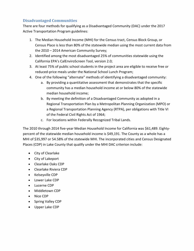
Disadvantaged Communities There are four methods for qualifying as a Disadvantaged Community (DAC) under the 2017 Active Transportation Program guidelines:
1. The Median Household Income (MHI) for the Census tract, Census Block Group, or Census Place is less than 80% of the statewide median using the most current data from the 2010 – 2014 American Community Survey;
2. Identified among the most disadvantaged 25% of communities statewide using the California EPA’s CalEnviroScreen Tool, version 2.0;
3. At least 75% of public school students in the project area are eligible to receive free or reduced-price meals under the National School Lunch Program;
4. One of the following “alternate” methods of identifying a disadvantaged community: a. By providing a quantitative assessment that demonstrates that the specific
community has a median household income at or below 80% of the statewide median household income;
b. By meeting the definition of a Disadvantaged Community as adopted in a Regional Transportation Plan by a Metropolitan Planning Organization (MPO) or a Regional Transportation Planning Agency (RTPA), per obligations with Title VI of the Federal Civil Rights Act of 1964;
c. For locations within Federally Recognized Tribal Lands.
The 2010 through 2014 five-year Median Household Income for California was $61,489. Eighty-percent of the statewide median household income is $49,191. The County as a whole has a MHI of $35,997 or 54.58% of the statewide MHI. The incorporated cities and Census Designated Places (CDP) in Lake County that qualify under the MHI DAC criterion include:
• City of Clearlake • City of Lakeport • Clearlake Oaks CDP • Clearlake Riviera CDP • Kelseyville CDP • Lower Lake CDP • Lucerne CDP • Middletown CDP • Nice CDP • Spring Valley CDP
• Upper Lake CDP

Four Census Designated Places in Lake County do not qualify as a Disadvantaged Community under the MHI criterion:
• Cobb CDP • Hidden Valley Lake CDP • North Lakeport CDP • Soda Bay CDP
No part of Lake County qualifies as a Disadvantaged Community under the CalEnviroScreen Tool. The 2017 ATP Guidelines limit the use of the free or reduced-price meals criterion to communities located within two miles of the schools represented in the project application.
Bicycle Infrastructure Chapter 8 of the California Streets and Highways Code governs non-motorized transportation infrastructure within the State. The State of California Department of Transportation (Caltrans) is given primary responsibility for implementing new and existing legislative requirements. The California Vehicle Code (CVC) governs the operation of vehicles, including bicycles, on public rights of way. Division 11 of the CVC establishes the rules of the road and Sections 21200-21212 apply specifically to the operation of bicycles. More about bicycle operation can be found under the non-infrastructure section of this plan.
Caltrans, in cooperation with county and city governments, is responsible for establishing the minimum design criteria for the bikeway types identified below and for roadways where bicycle travel is permitted. The design criteria are specified in the California Highway Design Manual (Chapter 1000) and the recently adopted NACTO (National Association of City Transportation Officials) Urban Bikeway Design Guide. The “NACTO Guide” was released in 2010 to address recently developed bicycle design treatments and techniques for urban settings as a way to establish “complete streets” for bicyclists and where the existing highway design guidelines had limited applicability.
Caltrans is also responsible for establishing uniform standards and specifications for signs, markers, and traffic control devices for bicycle facilities. These standards are published in the California Manual on Uniform Traffic Control Devices (California MUTCD), which is consistent with the Federal Highway Administration’s MUTCD and applies to all city, county, regional, and other local agencies responsible for the development or operation of bikeways or roadways where bicycle travel is permitted. Part 9, Traffic Control for Bicycle Facilities, applies to bicycle facilities and operation on both roadways and shared-use paths.

Bikeway Classifications Section 890.4 of the California Streets and Highways Code defines four (4) facility types that provide for and promote bicycle travel:
1. Class I Bikeways, also referred to as “bike paths” or “shared use paths,” provide a completely separated right-of-way designated for the exclusive use of bicycles and pedestrians with crossflows by motorists minimized.
2. Class II Bikeways, also referred to as “bike lanes", provide a restricted right-of-way
designated for the exclusive or semi-exclusive use of bicycles with through travel by motor vehicles or pedestrians prohibited, but with vehicle parking and crossflows by pedestrians and motorists permitted.
3. Class III Bikeways, also referred to as “bike routes," which provide a right-of-way on-
street or off-street, designated by signs or permanent markings and shared with pedestrians and motorists.
4. Class IV Bikeways, also referred to as “cycle tracks” or “separated bikeways," promote
active transportation and provide a right-of-way designated exclusively for bicycle travel adjacent to a roadway and which are protected from vehicular traffic. Types of separation include, but are not limited to, grade separation, flexible posts, inflexible physical barriers, or on-street parking.
Definitions Bicycle: A device upon which any person may ride, propelled exclusively by human power through a belt, chain, or gears, and having either two or three wheels in a tandem or tricycle arrangement.
Bicycle Commuter: A person making a trip by bicycle primarily for transportation purposes, including, but not limited to, travel to work, school, shopping, or other destination that is a center of activity, and does not include a trip by bicycle primarily for physical exercise or recreation with such a destination.
Bikeway: All facilities that provide primarily for, and promote, bicycle travel.
Shared Lane Markings: Also known as “sharrows”, these are pavement symbols designed to improve the positioning of bicyclists on roadways with regular bicycle use. Sharrows can be used on Class III Bikeways with parallel parking to channelize bikes away from the door swing zone.
Applicability of Bikeway Standards in the Lake APC Region For most parts of the Lake County Region, the most efficient use of construction funding for bicycle facilities is to provide Class II bike Lanes. The Active Transportation Program is less likely to fund Class III bike lanes, as they do not promote increased use by bicyclists of all abilities.
Due to generally limited road widths, close proximity to traffic and potential hazards at the edge of pavement such as steep drainage ditches and fixed objects, bicyclists of lesser ability consider Class III facilities to have an unacceptable exposure to risk. Class III facilities are most appropriate for low volume, low speed roads where bicycles can safely assume the travel lane.
Class I and Class IV facilities have limited applicability for most of Lake County as these types of projects generally require right of way acquisition, have an expanded environmental review, and substantially increase the cost of the project. Due to the overwhelming need for bicycle facilities in the region, and considering the limited supply of funding in relation to need, the region can provide more miles of bicycle facilities and provide better access to activity centers by developing Class II facilities.
The existing list of projects in the 2011 Regional Bikeway Plan points to a universal need for expanding bicycle travel throughout the region. No one community stands out as clearly more developed or built-out in terms of bikeways. Projects have historically been advanced according to project readiness and deliverability. As much as possible, investment should maintain a geographical equity in the implementation of projects as a way to provide equitable mobility and safety benefits for the region’s residents.
Pedestrian Infrastructure The Complete Streets Act of 2008 required the legislative body of a city or county, upon any substantive revision of the circulation element of the general plan, to modify the circulation element to plan for a balanced, multimodal transportation network that meets the needs of all users of streets, roads, and highways, which is defined to include motorists, pedestrians, bicyclists, children, persons with disabilities, seniors, movers of commercial goods, and users of public transportation, in a manner that is suitable to the rural, suburban, or urban context of the general plan.
Planning for pedestrian travel has historically been the responsibility of city government. Although the Lake Area Planning Council has developed regional bikeway plans to establish regional priorities for a countywide bicycle network, most pedestrian trips (for transportation purposes) are local. Planning for regional or interregional pedestrian travel has not previously taken place outside of the community context with the exception of recreational facilities. Increasing pedestrian travel for transportation purposes will require safe and convenient access to a mix of land uses. Additional planning and assessment of pedestrian facilities is needed for both local and regional levels.
The Active Transportation Plan requirements call for maps and descriptions of existing and proposed pedestrian facilities, including those serving major transit hubs and schools. The Active Transportation Plan has relied upon existing sources of data within the region and has not included any new studies to document the existence or absence of sidewalks or to identify

deficiencies in the existing pedestrian network. Additional community or neighborhood-level surveys are needed to provide a comprehensive, up-to-date inventory or assessment of the pedestrian network to ensure that the recommendations for pedestrian facilities are consistent with the Complete Streets Act of 2008.
Future pedestrian facility assessments could either be funded through the Caltrans Division of Transportation Planning or conducted by local public works engineers using the Institute of Transportation Studies publication: A Technical Guide for Conducting Pedestrian Safety Assessments for California Communities. The 2016 Lake Active Transportation Plan will establish short-term priorities and long-term recommendations for improving pedestrian infrastructure in the region.
Title II of the Americans with Disabilities Act (ADA) requires that state and local governments ensure that persons with disabilities have access to the pedestrian routes in the public right of way. An important part of this requirement is the obligation (where feasible) whenever streets, roadways, or highways are altered to provide curb ramps where street level pedestrian walkways cross curbs. This requirement is intended to ensure the accessibility and usability of the pedestrian walkway for persons with disabilities.
An alteration is a change that affects or could affect the usability of all or part of a building or facility. Alterations of streets, roads, or highways include activities such as reconstruction, rehabilitation, resurfacing, widening, and projects of similar scale and effect. Maintenance activities on streets, roads, or highways, such as filling potholes, are not alterations.
Transit Linkages A ‘trip’ is understood to be the entire journey between origin and destination. Public transportation agencies may provide bus service that constitutes the greatest portion of the trip, but transit riders often need to supplement the transit mode using other means of travel. Non-motorized travel is commonly used to arrive at the nearest transit stop, as well as to make the connection to the final destination. The routes to and from transit service are often referred to as the ‘first and last mile’ of the transit user’s entire trip.
The Lake Transit Authority was established in 1993 to provide transit service in a growing but still rural environment. Bus passenger facilities remain a significant deficiency, including trip-end bicycle facilities. LTA has installed bike lockers at one or two transit hubs; none at transit stops. Bike racks and bike lockers are typically provided on adjacent properties or not at all. Every bus in the LTA fleet has a rack to carry a minimum of two bicycles.
The California Household Travel Survey (2010-2012) surveyed 42,431 households from all 58 counties in California and determined that the average walking trip measures 0.3 miles in distance. The average bicycle trip measured 1.5 miles in distance. A common practice is to

provide pedestrian facilities within ½ to 1 mile of activity centers and transit stops, and up to two miles for bicycle facilities. Providing bicycle and pedestrian facilities and trip-end amenities within relative proximity to trip origin and destinations will help to achieve a number of goals of the Active Transportation Program, including:
• Reduce greenhouse gas emissions • Increase transportation choices • Provide lower cost transportation options • Reduce fuel consumption • Increase the number of people choosing to walk and bicycle for transportation purposes
as a way to increase physical activity and improve public health
Future studies can help to identify the origin and destination of transit users and target higher-use transit stops with safe and convenient bicycle and pedestrian access.
Safety Where collision records are strong indicators of safety improvement needs, funding may be available through the Active Transportation Program, the Highway Safety Improvement Program (HSIP), Office of Traffic Safety (OTS), or other State and federal discretionary funding sources. Safety projects are high priorities at all levels of government so a steady stream of funding can reliably be expected where collision rates are high enough or where collisions tend to be severe.
According to the Transportation Injury Mapping System (TIMS) and the Statewide Integrated Traffic Recording System (SWITRS), the Lake County region, which includes the County and the cities of Lakeport and Clearlake, experienced 105 pedestrian collisions over the ten-year history of available data. The unincorporated area of Lake County, not including roadways under the jurisdiction of Caltrans, had twenty-four pedestrian collisions reported during the same ten-year period, twenty-four pedestrian collisions were reported within the City of Clearlake, and twelve pedestrian collisions were reported in the City of Lakeport. Two of the pedestrian collisions in Clearlake and five of the pedestrian collisions on State Highways were fatal.
During the same ten-year period, the Lake County region experienced 59 collisions involving bicyclists. Four bicyclist fatalities were reported among the fifty-nine collisions. Twenty-five collisions were reported in the unincorporated County jurisdiction, fifteen collisions were reported in the City of Clearlake and two collisions were reported in the City of Lakeport.

Clearlake 2005-2014 Collision Severity
Total Collisions
Percent Bicycle Collisions
Percent Percent of Total
Pedestrian Collisions
Percent Percent of Total
Fatal 10 4.22% 0 0% 0% 2 8.33% 20% Severe Injury 23 9.70% 0 0% 0% 2 8.33% 8.7%
Visible Injury 79 33.33% 13 86.67% 16.46% 8 33.33% 10.13%
Complaint of Pain 125 52.74% 2 13.33% 1.6% 12 50% 9.6%
All Collisions 237 100% 15 100% 6.33% 24 100% 10.13%
Lakeport 2005-2014 Collision Severity
Total Collisions
Percent Bicycle Collisions
Percent Percent of Total
Pedestrian Collisions
Percent Percent of Total
Fatal 1 1% 0 0% 0% 0 0% 0% Severe Injury 3 3% 0 0% 0% 2 16.67% 66.67%
Visible Injury 22 22% 2 100% 9.09% 2 16.67% 9.09%
Complaint of Pain 74 74% 0 0% 0% 8 66.67% 10.81%
All Collisions 100 100% 2 100% 2% 12 100% 12%
County of Lake 2005-2014 Collision Severity
Total Collisions
Percent Bicycle Collisions
Percent Percent of Total
Pedestrian Collisions
Percent Percent of Total
Fatal 16 2.7% 0 0% 0% 0 0% 0% Severe Injury 90 15.18% 6 24% 6.67% 2 8.33% 2.22%
Visible Injury 253 42.66% 12 48% 4.74% 14 58.33% 5.53%
Complaint of Pain 234 39.46% 7 28% 2.99% 8 33.33% 3.42%
All Collisions 593 100% 25 100% 4.22% 24 100% 4.05%

State Highways 2005-2014 Collision Severity
Total Collisions
Percent Bicycle Collisions
Percent Percent of Total
Pedestrian Collisions
Percent Percent of Total
Fatal 94 5.83% 4 23.53% 4.26% 5 11.11% 5.32% Severe Injury 197 12.22% 5 29.41% 2.54% 14 31.11% 7.11%
Visible Injury 624 38.71% 7 41.18% 1.12% 13 28.89% 2.08%
Complaint of Pain 697 43.24% 1 5.88% 0.14% 13 28.89% 1.87%
All Collisions 1,612 100% 17 100% 1.05% 45 100% 2.79%
County-wide 2005-2014 Collision Severity
Total Collisions
Percent Bicycle Collisions
Percent Percent of Total
Pedestrian Collisions
Percent Percent of Total
Fatal 121 4.76% 4 6.78% 3.31% 7 6.67% 5.79% Severe Injury 313 12.31% 11 18.64% 3.51% 20 19.05% 6.39%
Visible Injury 978 38.47% 34 57.63% 3.48% 37 35.24% 3.78%
Complaint of Pain 1130 44.45% 10 16.95% 0.88% 41 39.05% 3.63%
All Collisions 2,542 100% 59 100% 2.32% 105 100% 4.13%
Northshore Pedestrian Safety Corridor Caltrans utilized Office of Traffic Safety funds to establish a pedestrian safety corridor along the Northshore portion of State Route 20 due to the high number of pedestrian and automobile collisions. The high number of interregional trips and through truck trips on State Route 20 conflict with the number of communities utilizing this route as main street. Pedestrian Safety Corridor signs are on either end of the corridor to alert drivers to the presence of bicycles and pedestrians along the route. Caltrans has also installed signs to provide notice that State Routes 29 and 53, along the south shore of Clear Lake, are the designated routes for trucks hauling hazardous materials.
Three Feet for Safety On September 16, 2014, California passed legislation requiring automobiles to provide three feet of separation between the vehicle and any bicyclists on the roadway. When the roadway is too narrow to pass bicyclists without crossing in front of on-coming traffic, vehicles must slow down and wait to pass until it is safe. This law became effective on September 16, 2014.

Maintenance The Lake Area Planning Council funds a regional Pavement Management Program (PMP) which monitors pavement condition for local streets and County roads. The PMP reports identify needs for maintaining roads and adjoining bicycle facilities. It also gives an indication of pavement smoothness and ADA level surfaces for roadway crossings. The most recent reporting was completed in June of 2015 and found that all three local jurisdictions in Lake County have poor overall road conditions. According to the 2014 Statewide Streets and Roads Needs Assessment, Lake County was one of nine counties statewide to be listed as having a poor overall pavement condition index. Additional local funds will be needed to make up for a lack of regional, State or federal funds for maintenance of all modal facilities.
None of the jurisdictions have maintenance programs for sidewalks. Sidewalks and vegetation control may be maintained with existing forces on an as-needed basis. Signs and striping have been maintained using Highway Safety Improvement Program (HSIP) funds when local funding was limited. Lighting and traffic signals are in limited use throughout the region.
The “5” E’s
Evaluation and Assessment Evaluation is one of the 5 E’s (Education, Encouragement, Engineering, Enforcement and Evaluation) and is often used with non-infrastructure projects as one of the approaches to promote and enhance Safe Routes to School efforts.
Evaluation and assessment, or monitoring, demonstrates how well transportation investments are spent and whether or not transportation policies and programs are effective in addressing the public’s need. MAP-21, the two-year (2012-2014) federal transportation funding (authorization) bill, established performance measures as a standard practice and future authorization bills are expected to continue this requirement.
Performance measures rely upon the establishment of benchmarks as a point for comparison over time. A concerted effort is necessary to monitor changes in conditions as improvements to the transportation system occur. Possible performance measures for Active Transportation modes in the Lake County region include:
• The number of trips made by walking and bicycling • The number of injuries and fatalities to bicyclists and pedestrians • The amount of ADA accessible sidewalks and street crossings • The total amount of sidewalks and bike lanes by jurisdiction
Other performance measures may be developed as needed to address safety, system preservation goals, mobility, accessibility, reliability, productivity, public health conditions, or other indicators affecting the benefits or services expected from the transportation system.

In the Lake County region, bicycle and pedestrian data is not currently collected to measure system performance. Lake APC monitors streets and highways for traffic volumes, prevailing speeds and consultants monitor pavement conditions. The CHP and Caltrans monitor collision history, including reported bicycle and pedestrian collisions. Bicycle and pedestrian collisions are only recorded if law enforcement files an incident report, which is less likely to occur for the less severe injuries. Implementing new data collection programs will require additional expense without the benefit of new funding sources.
Caltrans District 1 has initiated a non-motorized count program for Lake County. Due to the uncharacteristic travel patterns associated with the 2015 wildfire season, the first year of data is incomplete and data was not available for the Lake Active Transportation Plan. Processing the video counts is a time-intensive task so Caltrans has contracted with a specialist to process the counts on a periodic basis. The Caltrans data is limited to select locations on State highways, which may not provide information for some of the highest use non-motorized corridors.
At this time, no estimates for the number of bicycle or pedestrian trips are available for the region. Most methods for estimating volumes for active transportation modes assume that a bicycle and pedestrian count program is employed and that the counts can be incorporated into area travel demand or other simulation models. Theoretical estimates could be determined using California Household Travel Survey data or from manual counts with local data, but the lack of available data introduces a high degree of uncertainty and variability across the different parts of the county.
Enforcement Enforcement is often used with Safe Routes to Schools programs or projects due to the nature of non-infrastructure funding. The 2009 Lake County Safe Routes to School Plan includes a brief discussion of enforcement as an option for addressing safe routes to school efforts. Examples of enforcement activities include the posting of crossing guards, establishing school safety patrols, rewards programs (for good behavior), and sting operations where local law enforcement issues citations for moving violations within the school zone.
The Lake Area Planning Council has provided funding and technical support to school districts, State and local law enforcement units, and local public works staff when developing programs or task forces, associated with Safe Routes to School or other traffic safety needs. Periodic updates to the Safe Routes to School Plan and involvement with Safe Routes to School projects are methods for Lake APC staff to offer additional opportunities to promote or participate in enforcement activities.
The Active Transportation Program provides funding for non-infrastructure grants on a competitive basis for start-up or pilot projects. Supplemental non-infrastructure projects can be combined with infrastructure projects and result in an increase in the cost-benefit ratio for the

project, thus making the application more competitive. These types of projects are often combined with Safe Routes to School-type projects, but could be used to address other safety issues as well.
Education Safe Routes to School non-infrastructure projects consist primarily of education-related programs that target students and their parents. Students may attend school-wide assemblies focused on pedestrian and bicycle safety, take part in bicycle rodeos or bicycle maintenance workshops, and attend group walkabouts or walking audits. The intended outcomes of educational activities are to both increase the number of student trips traveling to and from school in the near term and to establish life-long healthful and environmentally-friendly habits.
Encouragement Encouragement activities have been used to target students to provide an impetus for choosing walking or bicycling as a first step in developing long-term habits of choosing non-motorized modes of transportation. Examples of Encouragement activities include: organizing walking school buses and bicycle trains; holding competitions centered around bicycling and walking; and offering incentives and rewards for students that frequently travel on foot or by bicycle.
While school children make an easy target for developing education, encouragement and enforcement programs, transportation and local government officials in the region are encouraged to seek opportunities to identify and reach out to the broadest possible range of groups within their respective communities.
Engineering Engineering involves “creating operational and physical improvements to the infrastructure surrounding schools that reduce speeds and potential conflicts with motor vehicle traffic, and establishing safer and fully accessible crossings, walkways, trails, and bikeways.” While education, encouragement, enforcement, and evaluation are all important, engineering will create the facilities for people to use. Engineering has led to successful Safe Routes to School projects in Upper Lake, Clearlake Oaks, and Clearlake.

Public Health In recognition of the impacts of public health on society, the Active Transportation Program promotes a “health in all policies” consideration in the planning and design of transportation infrastructure. Increasing opportunities for physical activity by walking or bicycling to local destinations, including schools, can form healthy habits and contribute to overall improvements in the public’s physical fitness. In Lake County, where agency staff and budgets are limited, pooling resources can increase the benefits provided to the community and help to achieve multiple goals.
Sutter Lakeside and St Helena Clear Lake have collaborated on the development of the 2013 Lake County Community Health Needs Assessment to comply with the Patient Protection and Affordable Care Act. These reports or assessments are to be completed on an on-going basis; with the first health needs assessment completed in 2010. Data is collected to identify public health issues, which is intended to allow health officials and policymakers to take a proactive approach to managing health care. Where public health can be improved through increased physical activity, transportation and public health officials may be able to work together to reach mutually beneficial goals. Active Transportation projects, both infrastructure and non-infrastructure, can target communities that demonstrate that increased physical activity would address one of the leading public health needs.
Wayfinding Signs Currently, none of the jurisdictions in Lake County have developed a wayfinding sign program. The limited extent of facilities for non-motorized travel puts a premium on the development of new facilities and reduces the immediate need for wayfinding signs. Programs that provide traveler information should be considered when developing and constructing bikeways, sidewalks and trails. The Active Transportation Plan and any subsequent, community specific bicycle or pedestrian studies can serve as a reminder for lead agencies to consider the need for wayfinding signs as a way to encourage broad use of active transportation facilities.

Community Outreach A grant from Caltrans’ surplus Rural Planning Assistance funds was used to hire Redwood Community Action Agency (RCAA) to conduct the public outreach for the Lake Active Transportation Plan. An advisory panel was assembled to direct the consultant with outreach for the two incorporated cities and for the two unincorporated communities where the outreach meetings were held. Panel members included representatives from the cities of Lakeport and Clearlake, Lake County Public Works Department, Community Development Department and the Public Health Department. Many of the advisory panel members also attended the public outreach events to assist with meeting facilitation and to take part in the dialogue with members of the public.
Public outreach meetings were held in Clearlake, Lucerne, Lakeport and Middletown. All of these communities are disadvantaged under the ATP Guidelines. These communities were selected to host community involvement workshops based on their location, which provides the greatest geographic equity in terms of accessibility by the majority of the region’s population.
Surveys were distributed throughout the County, both online and mail-in versions. A full account of public input is documented in a report by RCAA, which is included in Appendix B. A summary of the RCAA report is included in this section.
Survey results A total of 194 surveys were completed, including both on-line and mail-in formats. The following six factors were reported to have the biggest influence over whether to choose active modes of transportation in Lake County:
• Lack of sidewalks • Lack of bike lanes • Concerns about traffic • Concerns about pavement condition • Remoteness of destinations • Lack of time
Adding bike lanes, and potentially sidewalks, may coincide with roadway construction projects, which would address concerns about existing pavement conditions. Concerns about traffic suggest that a higher level of service be provided on arterial roads or alternate routes be considered. Remoteness of destinations and lack of time suggest that sidewalk and bikeway links to transit be emphasized in the near term. In the long term, changes in land use that increase density and the mix of land uses may further promote walking and bicycling.

City of Clearlake Redwood Community Action Agency conducted a public outreach meeting from 5 PM to 7 PM on Wednesday, October 28, 2015 at the Clearlake Senior Center. The City of Clearlake officials in attendance at the event invited Lake APC staff to present the Lake Active Transportation Plan at a City-hosted public meeting for the City Parks Master Plan, which took place on Tuesday, November 17 from 5 PM to 8 PM.
The key feedback received at the two public meetings includes the following points: • Include streetscape improvements, sidewalks, and beautification on Lakeshore Drive,
particularly in the vicinity of Redbud Park; • Construct sidewalks for the paved streets in the “Avenues” neighborhood, specifically
on 18th Ave, 32nd Ave and 40th Ave.
Lucerne On Thursday, October 29, RCAA conducted a public outreach meeting from 5 PM to 7 PM at the Marymount College Lake County Campus. Input received at the Lucerne outreach meeting included:
• Route 20 is narrow and unsuitable for bicyclists and pedestrians, particularly in Glenhaven and the eastbound approach to Clearlake Oaks;
• Develop bike and pedestrian trails parallel to State Route 20 through the paper subdivisions.
City of Lakeport On Wednesday, November 4, RCAA facilitated a public outreach meeting from 5 PM to 7 PM at the Lakeport Senior Center. Key comments received in Lakeport include:
• Sidewalks are needed on 11th Street, from Main Street to State Route 29, which is an important connector between State Route 29 and the city center. The City’s busiest shopping center is located on 11th street.
• Safe Routes to School Projects are needed at Clear Lake High School (in Lakeport), Terrace Middle School, Lakeport Elementary School, and Natural High School. These schools have adjoining campuses, which could all be served through focused Safe Routes to School projects.
Middletown On Thursday, November 5, RCAA facilitated a public meeting from 5 PM to 7 PM at the Calpine visitor center in Middletown. Input from Middletown included:
• A separated non-motorized facility is needed between Hidden Valley Lakes and Middletown as an alternate to State Route 29;
• Alternate and redundant corridors for non-motorized travel are needed for emergency evacuation routes.

Much of the input received from the public supported the development or implementation of bicycle or pedestrian improvements that are already identified as in one of the previous plans. Projects like the Bridge Arbor Bikeway were proposed for implementation, in this case using Transportation Enhancement (TE) funds, but have yet to be delivered. In the case of the Bridge Arbor project, the TE funds disappeared with the passage of MAP-21, the federal authorization bill for transportation funding from 2012 to 2015.
As a generalization, the more engaged members of the public support planned improvements that were identified during previous planning efforts. Demand for active transportation projects far exceeds the availability of funding.
***
In addition to consulting with the general public and the local agencies within the region, Lake APC staff provided opportunities for other input. Copies of the draft Lake Active Transportation Plan were circulated to school districts, Tribal governments, neighboring jurisdictions, air quality districts and RTPAs.

Goals, Objectives and Policies State and federal government continue to build on Complete Streets and air quality initiatives with new legislation, policies and practices that place a high priority on Active Transportation. Through Senate Bill 99 (2015), the State legislature adopted the Active Transportation Program and established the following goals:
• Increase the amount of local and regional trips accomplished by bicycling and walking; • Increase the safety and mobility for non-motorized modes of travel; • Advance or promote Active Transportation to achieve greenhouse gas emission
reductions consistent with Senate Bill 375 (2008); • Enhance public health, including the reduction of childhood obesity through programs
such as the Safe Routes to School; • Ensure that disadvantaged communities fully share in the benefits of the program; and • Provide a broad spectrum of projects to benefit many types of active transportation
users.
Funding is increasingly linked to State and federal goals and objectives and enforced through performance measures. The goal of the Lake Active Transportation Plan is to maintain consistency with priorities of the broader transportation leadership and to be able to compete for increasingly competitive transportation investment funds.
For the Lake County region, maintaining consistency with the Active Transportation Program means investing both focus and resources into developing a network of bicycle and pedestrian routes that separate bicycles and pedestrians from vehicular traffic. The limited resources that are generally available in rural areas make implementation a challenge. The policies in the following table are intended to guide the region and the local agencies in building infrastructure to meet the travel needs of a broader range of user types and abilities.
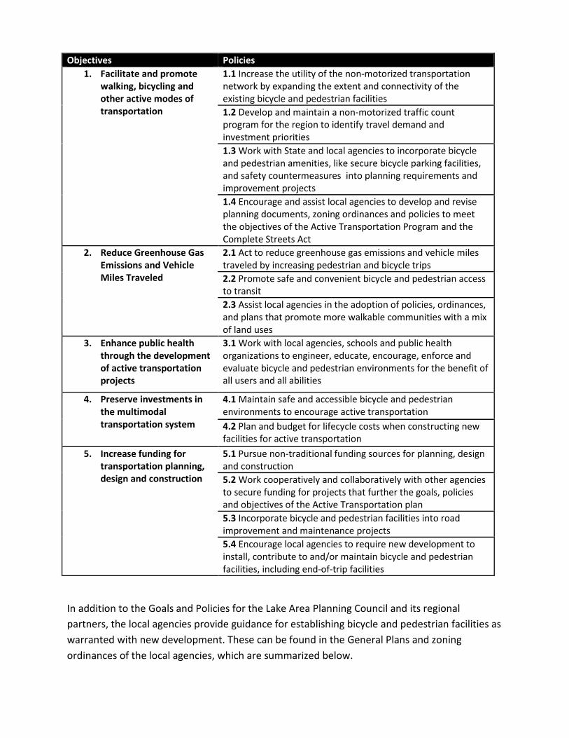
Objectives Policies 1. Facilitate and promote
walking, bicycling and other active modes of transportation
1.1 Increase the utility of the non-motorized transportation network by expanding the extent and connectivity of the existing bicycle and pedestrian facilities 1.2 Develop and maintain a non-motorized traffic count program for the region to identify travel demand and investment priorities 1.3 Work with State and local agencies to incorporate bicycle and pedestrian amenities, like secure bicycle parking facilities, and safety countermeasures into planning requirements and improvement projects 1.4 Encourage and assist local agencies to develop and revise planning documents, zoning ordinances and policies to meet the objectives of the Active Transportation Program and the Complete Streets Act
2. Reduce Greenhouse Gas Emissions and Vehicle Miles Traveled
2.1 Act to reduce greenhouse gas emissions and vehicle miles traveled by increasing pedestrian and bicycle trips 2.2 Promote safe and convenient bicycle and pedestrian access to transit 2.3 Assist local agencies in the adoption of policies, ordinances, and plans that promote more walkable communities with a mix of land uses
3. Enhance public health through the development of active transportation projects
3.1 Work with local agencies, schools and public health organizations to engineer, educate, encourage, enforce and evaluate bicycle and pedestrian environments for the benefit of all users and all abilities
4. Preserve investments in the multimodal transportation system
4.1 Maintain safe and accessible bicycle and pedestrian environments to encourage active transportation 4.2 Plan and budget for lifecycle costs when constructing new facilities for active transportation
5. Increase funding for transportation planning, design and construction
5.1 Pursue non-traditional funding sources for planning, design and construction 5.2 Work cooperatively and collaboratively with other agencies to secure funding for projects that further the goals, policies and objectives of the Active Transportation plan 5.3 Incorporate bicycle and pedestrian facilities into road improvement and maintenance projects 5.4 Encourage local agencies to require new development to install, contribute to and/or maintain bicycle and pedestrian facilities, including end-of-trip facilities
In addition to the Goals and Policies for the Lake Area Planning Council and its regional partners, the local agencies provide guidance for establishing bicycle and pedestrian facilities as warranted with new development. These can be found in the General Plans and zoning ordinances of the local agencies, which are summarized below.

Lakeport The Transportation Element in the City of Lakeport General Plan (2009) acknowledges that a number of residential areas lack sidewalks. Policy T 26.1 calls for the inclusion of sidewalks or pedestrian paths in all new street improvements. Sidewalks are now required with all new development. The City promotes the establishment of improvement districts to defray expenditures of City funds. The City intends to focus resources on projects with community-wide benefits. The City has called for a citywide inventory and map of existing sidewalks in relation to schools, parks, and major arterials to help identify priority areas for construction. To date, the City does not have a comprehensive map of pedestrian facilities.
Lakeport General Plan Policy T 22.1 calls for the dedication of land for the development of bicycle facilities in all new major land developments or for proposed developments in the an area designated as part of the Bikeways Plan. Bicycle and motorcycle parking is to be provided for all new parking facilities in excess of five spaces. The General Plan also calls for an amendment to the Zoning Ordinance to require such bicycle related amenities as bike rack/storage facilities for commercial/office, industrial and high density residential developments as well as park facilities. The city bikeway system is intended to increase the number of Class I and II facilities and bike storage at public transit facilities, commercial/office developments and schools as a way to promote greater bicycle use.
Clearlake The City of Clearlake is currently updating their General Plan to include a bigger emphasis on bicycle and pedestrian facilities. The City has been working under a variety of policy and planning documents to enhance bicycle and pedestrian facilities. The City’s Parks Master Plan requires trip-end bicycle facilities at all City parks and City ordinances include provisions for bicycles with off-street parking requirements. Proposed policy language for the Draft 2040 General Plan calls for the establishment of multimodal transit hubs, inclusion of multi-modal facilities to improve access and connectivity within and between neighborhoods, new bicycle and pedestrian networks as a requirement for new development, bicycle parking requirements for multi-family residential and non-residential land uses, and establishment and maintenance of a city-wide bikeway master plan. The General Plan is scheduled to be approved in 2016 with a comprehensive update to the zoning code to follow in 2017.
Lake County The General Plan for Lake County includes policies for developing a safe, continuous and accessible network for alternative modes of travel. Non-motorized transportation is to be considered in all new development and transportation infrastructure projects. Bicycle access and parking facilities are to be incorporated at office buildings, schools, shopping centers and parks.

Action Plan The Action Plan for the Lake Active Transportation Plan shows both constrained and unconstrained priority projects. The constrained projects are either currently programmed in the State Transportation Improvement Program (STIP) or identified by local agencies as scheduled for funding through local budgets. In some cases, projects have been awarded grant funding and construction is expected in the next three years. The availability of funding provides the constraints. Unconstrained projects have been identified to build out the bicycle infrastructure and to a lesser extent the pedestrian infrastructure. The unconstrained lists of projects do not consider the availability of funding, just the need.
The Active Transportation Program is the primary source of funds dedicated to non-motorized transportation. Because these funds are discretionary, the majority of identified projects will be unconstrained until such a time as projects are awarded. The Lake Area Planning Council or its member agencies will need to conduct a prioritization process for the list of unconstrained projects for each grant cycle to determine which projects to advance. A sample methodology for prioritizing projects has been developed by the Lake APC staff to assist with the project prioritization process. The criteria are included at the end of this section. The draft weighting criteria is included in Appendix D.
City of Lakeport There is currently only one active transportation project in the City of Lakeport with a dedicated funding source at this time. The first is Phase II of the Downtown Improvement Plan. The project will improve nearly ¼ mile of North Main Street (from 1st Street to 4th Street) by widening sidewalks and effectively reducing the travel lane width through the incorporation of “sharrows” to better accommodate bicyclists.
2016 Active Transportation Plan Bicycle and Pedestrian Project List – Financially Constrained Project Name Timeframe Cost (in $1,000s) Funding Source(s) Downtown Improvement Plan Phase II, Main Street 1 – 5 years $2,200 RDA
The City may use General Fund or Measure I funds to initiate bicycle and pedestrian improvements on Eleventh Street, which has one of the busiest shopping centers in town but has limited access for non-motorized travel. Supplemental funding will be needed to complete the right of way acquisition and construction, despite the fact that this project remains one of their highest unfunded priorities.

Safe Routes to School projects, Main Street improvements and other downtown and lakefront areas can be broken into smaller segments and are considered to be less complex. These can be designed and built within the timeframe of the Active Transportation Program grants. It is unlikely that all of these projects will be built within the desired timeframe. The unconstrained list shows the relative priority of each project although not necessarily achievable timeframes. Additional prioritization will be needed.
2016 Active Transportation Plan Bicycle and Pedestrian Project List – Financially Unconstrained Project Name Timeframe Cost (in $1,000s) Funding Source(s) Safe Routes to School (Lange, 20th, Lakeshore, Hartley, Giselman)
1 – 10 years TBD ATP, RTIP, HSIP
Martin St. (Bevins to Main) 1 – 10 years TBD ATP, RTIP, HSIP Hartley Road (20th to City Limits) 1 – 10 years TBD ATP, RTIP, HSIP
North High Street (11th to 20th Street) 1 – 10 Years TBD ATP, RTIP, HSIP
Bevins St. (Lakeport Blvd. to Martin Street) 10 – 20 years TBD ATP, RTIP, HSIP
Eleventh St. (Hwy 29 to North Main St.) 10 – 20 years TBD ATP, RTIP, HSIP
Lakeport Blvd. (South Main Street to Parallel Drive) 10 – 20 years TBD ATP, RTIP, HSIP
Safe Routes to School (Fairview, Forest, Hillcrest, Sayre, Terrace)
10 – 20 years TBD ATP, RTIP, HSIP
Downtown: Main St., Forbes St., Park St. between Martin & 11th St.
10 – 20 years TBD ATP, RTIP, HSIP
South Main Street (Lakeport Blvd to City Limits) 10 – 20 years TBD ATP, RTIP, HSIP
Lakefront Promenade 10 – 20 years TBD ATP, RTIP, HSIP Parallel Drive (Mendocino College to Westside Park Rd.) 10 – 20 years TBD ATP, RTIP, HSIP
20th Street (N. High to Alden) 10 – 20 years TBD ATP, RTIP, HSIP Hwy 175 (Parallel Drive to S. Main Street) 10 – 20 years TBD ATP, RTIP, HSIP
Esplanade and C Streets 10 – 20 years TBD ATP, RTIP, HSIP Forbes Creek Trail 10 – 20 years TBD ATP, RTIP, HSIP Howard Ave Trail 10 – 20 years TBD ATP, RTIP, HSIP 6th Street (Main to Hwy 29) 10 – 20 years TBD ATP, RTIP, HSIP Westside Park Road 10 – 20 years TBD ATP, RTIP, HSIP First Street 10 – 20 years TBD ATP, RTIP, HSIP
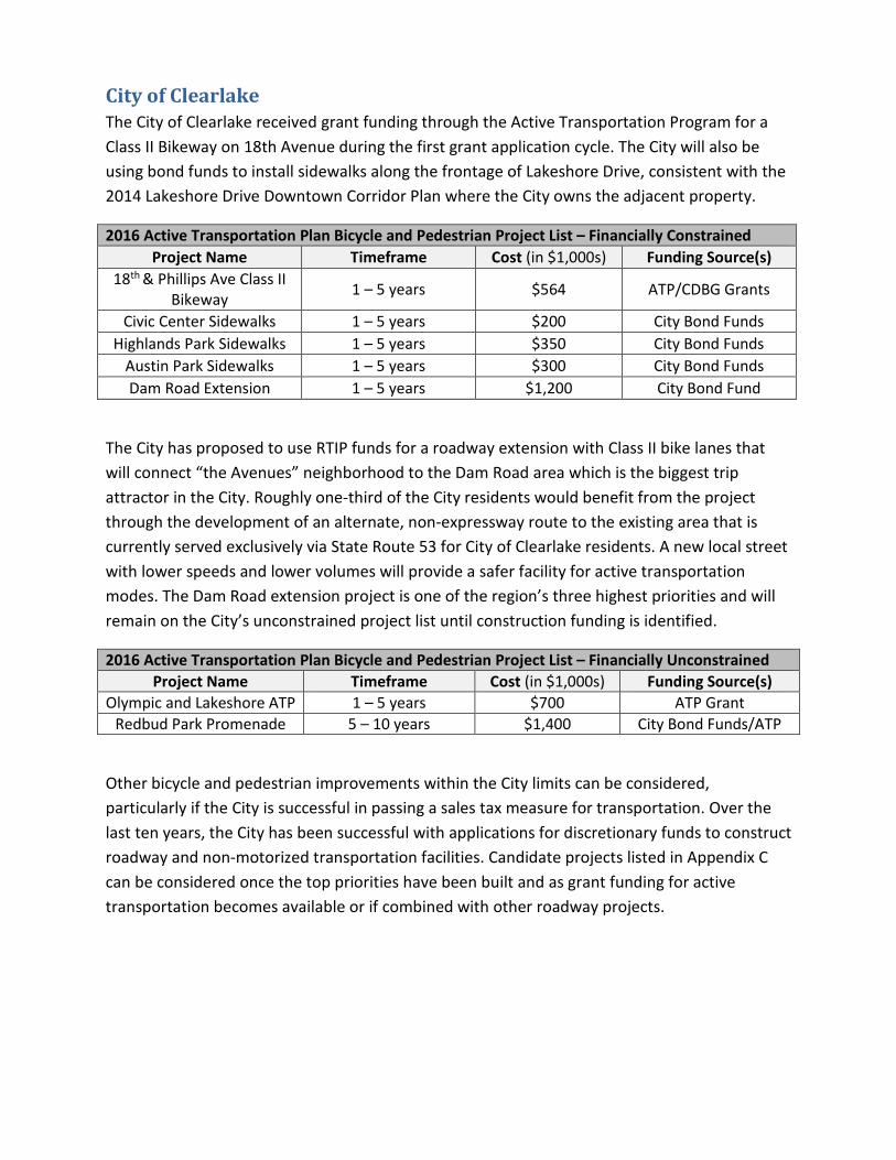
City of Clearlake The City of Clearlake received grant funding through the Active Transportation Program for a Class II Bikeway on 18th Avenue during the first grant application cycle. The City will also be using bond funds to install sidewalks along the frontage of Lakeshore Drive, consistent with the 2014 Lakeshore Drive Downtown Corridor Plan where the City owns the adjacent property.
2016 Active Transportation Plan Bicycle and Pedestrian Project List – Financially Constrained Project Name Timeframe Cost (in $1,000s) Funding Source(s)
18th & Phillips Ave Class II Bikeway 1 – 5 years $564 ATP/CDBG Grants
Civic Center Sidewalks 1 – 5 years $200 City Bond Funds Highlands Park Sidewalks 1 – 5 years $350 City Bond Funds
Austin Park Sidewalks 1 – 5 years $300 City Bond Funds Dam Road Extension 1 – 5 years $1,200 City Bond Fund
The City has proposed to use RTIP funds for a roadway extension with Class II bike lanes that will connect “the Avenues” neighborhood to the Dam Road area which is the biggest trip attractor in the City. Roughly one-third of the City residents would benefit from the project through the development of an alternate, non-expressway route to the existing area that is currently served exclusively via State Route 53 for City of Clearlake residents. A new local street with lower speeds and lower volumes will provide a safer facility for active transportation modes. The Dam Road extension project is one of the region’s three highest priorities and will remain on the City’s unconstrained project list until construction funding is identified.
2016 Active Transportation Plan Bicycle and Pedestrian Project List – Financially Unconstrained Project Name Timeframe Cost (in $1,000s) Funding Source(s)
Olympic and Lakeshore ATP 1 – 5 years $700 ATP Grant Redbud Park Promenade 5 – 10 years $1,400 City Bond Funds/ATP
Other bicycle and pedestrian improvements within the City limits can be considered, particularly if the City is successful in passing a sales tax measure for transportation. Over the last ten years, the City has been successful with applications for discretionary funds to construct roadway and non-motorized transportation facilities. Candidate projects listed in Appendix C can be considered once the top priorities have been built and as grant funding for active transportation becomes available or if combined with other roadway projects.

County of Lake Lake County was recently awarded two Active Transportation Project grants in Cycle 2 of the Program: The Middletown Multi-Use Trail and the Upper Lake Safe Routes to School Project.
2016 Active Transportation Plan Bicycle and Pedestrian Project List – Financially Constrained Project Name Timeframe Cost (in $1,000s) Funding Source(s)
Middletown Multi-Use Trail 1 – 5 years 1,429 ATP Upper Lake Safe Routes to School Project 1 – 5 years 481 ATP
South Main Street/Soda Bay Road Widening Project 1 – 10 years $6,100 RTIP
The Regional Bikeway Plan identified primary routes for bicycle travel to all corners of the County, connecting cities, unincorporated communities, and routes extending into neighboring counties. The bulk of the network is within unincorporated portions of the County. The County has been successful applying discretionary funding, however, despite building at least one project per year, the list of needs is still overwhelming for the limited number of staff on-hand.
A methodology for prioritizing projects has been developed by Lake APC staff to assist the County with objectively selecting projects based on functional classification, roadway data and project readiness. The weighted system of prioritizing the candidate projects identified in Appendix C will assist the County to deliver an equitable distribution of non-motorized benefits across the County. The selection criteria are consistent with the 2017 ATP Guidelines and can be modified in the future to remain consistent with the ATP Guidelines as they are updated. The weighting system is included in Appendix D.
Lake Transit Authority The first step to prioritizing transit oriented active transportation projects is to conduct a study that identifies the origin and destination of transit users and targets higher-use transit stops with safe and convenient bicycle and pedestrian access. Once this is complete, Lake Transit Authority can work with the Lake Area Planning Council and the local agencies to secure funding to complete priority projects.

Insert Bicycle and Pedestrian Maps Below

Funding Sources Local Sources Generally speaking, none of the local governments within the region have a dedicated source of funding for bicycle, pedestrian or bus passenger facilities. The City of Lakeport has a one-half cent sales tax measure to supplement their general fund. This is not a dedicated source of transportation funding but transportation construction and maintenance are allowable expenses. The Lakeport Public Works Department has developed projects that have improved bicycle and pedestrian travel, but those funds were mingled with costs for roadway improvements so past year expenditures for Bike and Pedestrian improvements is not available.
In the City of Clearlake, Regional Surface Transportation Program (RSTP) and Highway Users Tax Account (HUTA) funds are rapidly shrinking and the City has no permanent source of transportation funding. The City has passed a bond measure for public infrastructure, which has been used for matching funds for discretionary projects as well as bicycle and pedestrian improvements. The majority of active transportation improvement funds over the last ten years have come from discretionary sources. Since 2006, the City of Clearlake has received $1,033,700 in Safe Routes to School funding, $478,000 in Transportation Enhancement (TE) funding, $368,000 in HSIP funds for bike lane striping, and $564,000 in Active Transportation Program funds. Additional revenues for roadway improvements, which included bicycle and pedestrian facilities, were received from Surface Transportation Improvement Program (STIP), Federal Emergency Management Agency (FEMA), American Recovery and Reinvestment Act (ARRA), Community Development Block Grant (CDBG) and Proposition 1B funds.
The County has been successful in applying for Safe Routes to School projects, Highway Safety Improvement Program funds, and High Risk Rural Road Funds. The dollar amounts dedicated exclusively to bicycle and pedestrian elements is not readily available.
Transportation Development Act (TDA) The Transportation Development Act provides funding for public transportation through the Local Transportation Fund (LTF) and the State Transit Assistance (STA) fund. These funds come from sales tax revenues that are generated locally. Lake APC annually allocates 2% of the regional LTF allocation for funding bicycle, pedestrian or ADA projects through a competitive process. These funds can also be used by local agencies as a match for competitive grants, such as the Active Transportation Program.

State Transportation Improvement Program (STIP) The STIP has historically been the primary source of improvement funds in the Lake County Region for capital projects, as opposed to maintenance or rehabilitation projects. STIP funds have been declining since their inception, but since 2015, these funds have fallen short of projections. In 2016, approximately one-third of the projects programmed for funding beyond the current cycle have had to be removed to make up for a statewide $750 million shortfall in tax revenues. A legislative fix is needed to restore this program to a functional level. Should this funding source remain a viable source of active transportation funding, eligible projects include: improving state highways, local roads, public transit (including buses), pedestrian and bicycle facilities, grade separations, intermodal facilities and safety projects.
Regional Surface Transportation Program (RSTP) Regional Surface Transportation Program funds are distributed annually by the APC to each local entity on a formula basis and may be used on local streets and roads projects, including improvements for bikeway and pedestrian facilities. The source of these funds is the federal Surface Transportation Program.
Active Transportation Program (ATP) Senate Bill 99 established the Active Transportation Program to combine State and federal funding sources, such as the Bicycle Transportation Account, the State and federal Safe Routes to School programs, the Transportation Alternatives Program (formerly the Transportation Enhancement program) and the federal Recreational Trails Program into a single pot of funds. The goal was to create one program for funding non-motorized transportation improvements, rather than carve out a number of programs, each with its own goals and a limited amount of funding. Another benefit of combining the funds is an ability to fund more substantial projects that will have a bigger impact on the way Californians travel. Greater investment in non-motorized infrastructure should induce more people to choose a more sustainable, cost-effective mode of travel.
With the current emphasis by the State for developing a more sustainable transportation network, the amount of funding for active modes of transportation has become one of the more reliable and substantial sources of revenue available for improvement projects. While resources for capital improvements dedicated to streets and highways have become more difficult to obtain, the Lake APC region is expected to dedicate more effort to improving the limited bikeway and pedestrian network.

Transportation Alternatives Program (TAP) The TAP provides funding for programs and projects defined as transportation alternatives, including on- and off-road pedestrian and bicycle facilities, infrastructure projects for improving non-driver access to public transportation and enhanced mobility, community improvement activities, and environmental mitigation; recreational trail program projects; safe routes to school projects; and projects for planning, designing, or constructing boulevards and other roadways largely in the right-of-way of former Interstate System routes or other divided highways.
Federal Safe Routes to School Program (SRTS) Safe Routes to School is a federal program that strives to increase the number of children who walk or bicycle to school by funding projects that remove the barriers that currently prevent them from doing so. Those barriers include lack of infrastructure, unsafe infrastructure, lack of programs that promote walking and bicycling through education/encouragement programs aimed at children, parents, and the community.
Recreation Trails Program
The Recreational Trails Program is funded through the federal transportation authorization bill and amounts to more than $5 million per year. Federal funds come with stipulations as to how that funding is to be spent. Example project types under the federal Recreational Trail Program include:
• Maintenance and restoration of existing trails. • Development and rehabilitation of trailside and trailhead facilities and trail linkages. • Purchase and lease of trail construction and maintenance equipment. • Construction of new trails (with restrictions for new trails on Federal lands). • Acquisition of easements or property for trails. • Assessment of trail conditions for accessibility and maintenance. • Up to 5% of the allocation for each State can fund the development and
dissemination of publications and the operation of educational programs to promote safety and environmental protection, (as those objectives relate to 1 or more of the use of recreational trails, supporting non-law enforcement trail safety and trail use monitoring patrol programs, and providing trail-related training); and
• Up to 7% of the allocation for each State can fund State administrative costs for the program.
The Federal Highway Administration is responsible to ensure that States use 30 percent of Recreational Trail funds for motorized trail uses, 30 percent for non-motorized trail uses, and 40 percent for diverse trail uses. Diverse motorized projects (such as snowmobile and motorcycle) or diverse non-motorized projects (such as pedestrian and equestrian) may satisfy
two of these categories at the same time. States are encouraged to consider projects that benefit both motorized and non-motorized users, such as common trailhead facilities. Many States give extra credit in their selection criteria to projects that benefit multiple trail uses.
Community Development Block Grant (CDBG) The program is a flexible program that provides communities with resources to address a wide range of unique community development needs. The CDBG program is a U.S. Department of Housing and Urban Development (HUD) program administered by the State of California. Within the parameters of the program, one of a number of eligible project categories includes the construction or reconstruction of streets, including bike lanes and sidewalks. The County of Lake and the City of Clearlake have successfully applied for CDBG funds for projects that include street improvements.
Office of Traffic Safety (OTS) The OTS program offers grant funding to assist local agencies with bicycle and pedestrian safety and educational programs. Grants are awarded on a statewide, competitive basis and are not available for construction of bikeway facilities.
***
As traditional funding sources have become less able to meet the continuing demand for transportation investment, the challenge to obtain project funding requires both creativity and coordination with other agencies. This is especially true when funding bicycle and pedestrian projects, which are often considered a lower priority than road projects and may not be eligible or competitive for traditional transportation funding sources.

Implementation
Steps Necessary to Implement the Plan The first step in the implementation of the plan is for the Lake Area Planning Council to adopt this plan as a prerequisite for applying grant funding from the Active Transportation Program. The CTC has not enforced this requirement in the first cycles of the grant program in order to allow agencies time to prepare Active Transportation Plans, but this is expected to change as more and more agencies develop Active Transportation Plans. The Lake Area Planning Council has prepared this plan, in part, to benefit the local governments in the region as well. By adopting the Lake Active Transportation by resolution, the County of Lake, the City of Lakeport and the City of Clearlake will have met the requirements and the intent of the Active Transportation Program.
Reporting Process As the non-motorized element of the Regional Transportation Plan (RTP), future RTP updates will include an update of the Active Transportation Plan. The plan updates will include a description of funds spent on Active Transportation facilities, maps of built facilities and new priorities, which will identify the progress made towards stated priority projects. Future updates of the Lake Active Transportation Plan will include local agency participation and provide the public with opportunities for input. The plan updates will be presented for adoption by the Lake APC Board and the local jurisdictions at the respective public hearings.
Revenue Sources The Active Transportation Program is funded in part through federal sources, including the Transportation Alternatives Program (TAP) and the federal Safe Routes to School Program. The federal funding stream has been comparatively stable in relation to State revenues. The CTC has maintained an annual program of $120 million while other programs, most notably the STIP, have been substantially reduced. The minimum funding amount for construction projects is $250 thousand. The Active Transportation Program is expected to fund the bulk of the Lake Active Transportation Plan priorities until transportation funding is restructured through the legislature and/or other funding sources become available.
Transportation Development Act funds authorize 2% of the regional allocation to be spent on bicycle and pedestrian facilities, which in Lake County amounts to a few tens of thousands of dollars per year. Due to the limited size, these funds have been used to construct curb ramps and improve sidewalks to meet ADA accessibility requirements. These funds may also be used as matching funds for larger projects.

Pedestrian Infrastructure The Bicycle Transportation Account was instrumental in developing a comprehensive network of County and local roads that, when improved to the desired bikeway standard, will meet the essential mobility and accessibility needs of bicycle commuters in the region. The pedestrian infrastructure was assessed in the 2009 Countywide Safe Routes to School Plan, which includes limited mapping of sidewalks near public schools but the maps are not comprehensive. In some locations, gaps in sidewalks were not identified as potential sidewalk projects, perhaps because some communities reject the policy of constructing ubiquitous sidewalks due to a preference for a rural appearance to their neighborhood or community. Sidewalks provide an elevated path for a very vulnerable mode of travel. The physical separation created by the sidewalk provides a significant safety benefit that can’t be ignored in highly traveled corridors.
Additional assessments and evaluations are needed to better evaluate the existing and the desired pedestrian improvements at the community level. Rural Planning Assistance funds and Sustainable Communities Transportation Planning Grants are Caltrans-administered funds that can be used to further define work needed for pedestrian improvements, a more comprehensive mix of travel modes for each community, or for other defined planning areas.
Updates to General Plans and Circulation Elements can help to build complete streets and livable/walkable communities. New development and public investment can help to create more pedestrian-friendly environments. Factors influencing pedestrian activity include the following land use contexts:
1. Population density 2. Small blocks or grid system of streets 3. A mixture of land uses 4. Safe and convenient pedestrian facilities
The table of criteria for prioritization, presented later in this section, identifies a number of considerations that can be used to prioritize candidate proposals for Active Transportation Program grant funds. Many of the criteria listed are used to evaluate proposals for consistency with the goals and objectives of the program and are therefore useful in selecting projects with the greatest potential for being awarded.
Bicycle Infrastructure A significant number of bikeways are needed to complete a safe and connected network. A list of candidate projects for both bikeways and sidewalks are identified in Appendix C. The candidate bicycle projects, when built out, will become primary routes for regional travel. Local jurisdictions will need to ensure that the local streets and roads adequately serve residential

areas or recreational needs. A weighted system for prioritizing candidate projects, included in Appendix D, is provided to supplement the unconstrained project lists in the preceding Action Plan. In the absence of safety concerns or other obvious region-wide benefits, the weighted prioritization method will be an accepted method for prioritizing projects within the region. A simplified list of criteria for prioritization is provided below.
Implementation Costs Planning level estimates for construction costs give some idea of the funding needed to build the regional bikeway infrastructure network. Additional inventory work and assessment is needed to determine the amount or extent of pedestrian improvements as a basis for estimating needs for the region. A preliminary engineering estimate will be needed in order to justify requests for grant funds.
Construction Cost Assumptions for Bikeway Improvements Facility Type Number of Miles Cost per Mile Total Cost Class I Path 8.54 $1,000,000 $8,540,000 Class II Bike Lane 79.87 $300,000 $23,961,000
Total 88.41 $32,501,000
Construction Cost Assumptions for Pedestrian Improvements Facility Type Unit Cost Concrete Sidewalk Square Foot $15 Curb & Gutter Linear Foot $40 Pedestrian Ramp Each $7,000 Pedestrian Crossing Signs Each $375 Countdown Signal Heads Each $650 5-Foot A/C Pathway Linear Foot $50 Street Lights Each $2,000 Overhead Flashing Light Each $50,000

Criteria for Prioritization Where current or projected volume of bicycles and pedestrians is high, to reduce GHG emissions
Where current or projected volume of traffic is above 2,000 AADT, to increase modal choice
Where vehicular speed is greater than 35 mph, to reduce severity of accidents
Where existing safety concerns exist, to reduce the frequency of accidents
Within two miles of schools, to increase safety of active students
Within 1 mile of transit stops or within 2 miles of transit hubs, to promote greenhouse gas reduction
Where funds may be leveraged, to more efficiently spend Active Transportation funds
Improvement project that includes a bicycle and pedestrian component
Within one mile of senior or disabled services facilities, to provide equity and serve all abilities
Within a disadvantaged community, to provide equity with public funds and economic stimulation
Where non-motorized facilities are lacking and alternate routes do not exist
Within 2 miles of commercial districts, employment centers, and other community resources and senior centers, to expand accessibility to and among activity centers Where new links can be created to connect trip attractors or generators within a ½ mile proximity
Project includes education, encouragement, evaluation or enforcement component
Identified in other/previous planning processes and documents
Has documented public support for the project
Targets populations with high risk factors for obesity, heart disease, asthma or other health issues
Proposal includes an analysis of project alternatives, to increase cost effectiveness
Where the project proposes to exceed design standards, to promote increased use by active modes
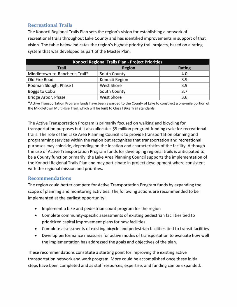
Recreational Trails The Konocti Regional Trails Plan sets the region’s vision for establishing a network of recreational trails throughout Lake County and has identified improvements in support of that vision. The table below indicates the region’s highest priority trail projects, based on a rating system that was developed as part of the Master Plan.
Konocti Regional Trails Plan - Project Priorities Trail Region Rating
Middletown-to-Rancheria Trail* South County 4.0 Old Fire Road Konocti Region 3.9 Rodman Slough, Phase I West Shore 3.9 Boggs to Cobb South County 3.7 Bridge Arbor, Phase I West Shore 3.6 *Active Transportation Program funds have been awarded to the County of Lake to construct a one-mile portion of the Middletown Multi-Use Trail, which will be built to Class I Bike Trail standards.
The Active Transportation Program is primarily focused on walking and bicycling for transportation purposes but it also allocates $5 million per grant funding cycle for recreational trails. The role of the Lake Area Planning Council is to provide transportation planning and programming services within the region but recognizes that transportation and recreational purposes may coincide, depending on the location and characteristics of the facility. Although the use of Active Transportation Program funds for developing regional trails is anticipated to be a County function primarily, the Lake Area Planning Council supports the implementation of the Konocti Regional Trails Plan and may participate in project development where consistent with the regional mission and priorities.
Recommendations The region could better compete for Active Transportation Program funds by expanding the scope of planning and monitoring activities. The following actions are recommended to be implemented at the earliest opportunity:
• Implement a bike and pedestrian count program for the region • Complete community-specific assessments of existing pedestrian facilities tied to
prioritized capital improvement plans for new facilities • Complete assessments of existing bicycle and pedestrian facilities tied to transit facilities • Develop performance measures for active modes of transportation to evaluate how well
the implementation has addressed the goals and objectives of the plan.
These recommendations constitute a starting point for improving the existing active transportation network and work program. More could be accomplished once these initial steps have been completed and as staff resources, expertise, and funding can be expanded.

Appendices
A. Lake Active Transportation Plan Adopting Resolutions
B. Community Involvement
C. List of Projects by Jurisdiction
D. Weighting Criteria for Project Prioritization
Appendix A
Lake Active Transportation Plan Adopting Resolutions

Appendix B
Community Input

Lake County Active Transportation Plan Community Outreach Report
December 2015 Prepared for: Lake Area Planning Council
Prepared by: Redwood Community Action Agency Natural Resources Services division
904 G Street, Eureka CA 95501

Contents of this Report: 1) Purpose of Outreach 2) Outreach Methods 3) Input Opportunities 4) Public Input Results and Key Themes Identified 5) Conclusion
Appendices
1) PURPOSE OF OUTREACH The purpose of the community outreach component of this project was to gather public feedback, priorities and ideas regarding active transportation in Lake County. Residents of Lake County were asked about their use of active modes of transportation, where there are needs for both infrastructure and non-infrastructure improvements, and for any additional input they wished to give to help improve active transportation (including transit, as all transit users complete at least a portion of their trip using active transportation.) To this end, outreach was conducted countywide via surveys (available in print or electronic format) and at workshops in four communities, including: Clearlake, Lucerne, Lakeport and Middletown. For the purposes of this report, “consultant team” refers to staff of Redwood Community Action Agency’s Natural Resources Services division, selected as consultants to support Lake Area Planning Council’s goal of garnering public input on the Lake Active Transportation Plan.
2) OUTREACH METHODS Outreach methods were selected by the consultant team with review and approval by Lake APC staff and a stakeholder advisory group comprised of representatives from local jurisdictions, Caltrans District 1, and Lake Transit. Outreach Method Overview The consultant team used various methods of communication to outreach to Lake County residents and stakeholders. These included: radio public service announcements in both English and Spanish (sent to Bicoastal Media, KBBF and KWINE), creation of social media content for distribution by local partners, press releases to local papers (sent to Lake County Record-Bee and Clearlake Observer-American), creation and distribution of flyers in both English and Spanish, emailing and faxing of flyers, surveys and workshop information, and direct phone calls inviting participation. Local stakeholders were heavily utilized to help spread the word, including local governments, Family Resource Centers, schools, tribal representatives and community-based organizations dedicated to supporting active transportation and public health.

Stakeholder Involvement Stakeholders invited to participate at a stakeholder advisory level included representatives from local governments (planning, public works, engineering and roads staff; City Councilmembers, Town Hall representatives and County Supervisors), tribes, Lake APC Board and staff, public health advocates such as the Health Leadership Network and the Hope Rising Coalition and trail groups such as Konocti Regional Trails. Conference calls and an in-person meeting with stakeholders were held prior to the workshops to get thorough input about where to focus outreach, how to present the information and most effectively get input. Outreach to Lake County Tribes The seven Tribes – the Big Valley Band of Pomo Indians of the Big Valley Rancheria, Elem Indian Colony of Pomo Indians/ Sulfur Bank Rancheria, the Habematolel Pomo of Upper Lake, Koi Nation of the Lower Lake Rancheria, Middletown Rancheria of Pomo Indians, Robinson Rancheria of Pomo Indians and Scotts Valley Band of Pomo Indians - in Lake County were contacted by the consultant team, via email, phone and fax. In addition, a local Tribal Health Forum representative and Caltrans Native American Liaison were contacted for additional input.

Outreach to Latino Community The consultant team worked with an experienced translator to develop outreach materials and surveys in Spanish. This included a radio ad/ public service announcement in Spanish which was played on stations with Spanish-language programming. The Clearlake-based Latino Health Clinic, La Voz de la Esperanza Centro Latino, which serves many people in Clearlake and beyond and is the only clinic of its kind in the County, helped with outreach to Spanish speakers. Their staff distributed paper surveys and was available to provide interpretation at the workshops. The consultant team had simultaneous interpretation equipment on-hand for Spanish translation.
3) INPUT OPPORTUNITIES The input opportunities consisted of the following:
• A one-page, 12 question survey, which was made available electronically in both English and Spanish, as well as distributed in English and Spanish in printed form to the Lakeport public library, Lakeport Main Street Bicycles, La Voz de la Esperanza Centro Latino in Clearlake, Clearlake Senior Center, Lakeport Senior Center, Middletown Senior Center, Middletown Community Center, Lakeport and Kelseyville Family Resource Centers, Marymount California University in Lucerne and other locations. (See Appendix 4 – Survey in English and Spanish.)
• Four community workshops, consisting of a presentation by the consultant team and opportunities for feedback and attendee prioritization of possible active transportation improvements by writing their ideas and needs on the following:
o Multiple strategy posters (in English and Spanish) which depicted various infrastructure and non-infrastructure strategies which could be used and encouraged participants to write down specific locations where these strategies would be appropriate. (See Appendix 5 – Strategy Posters.)
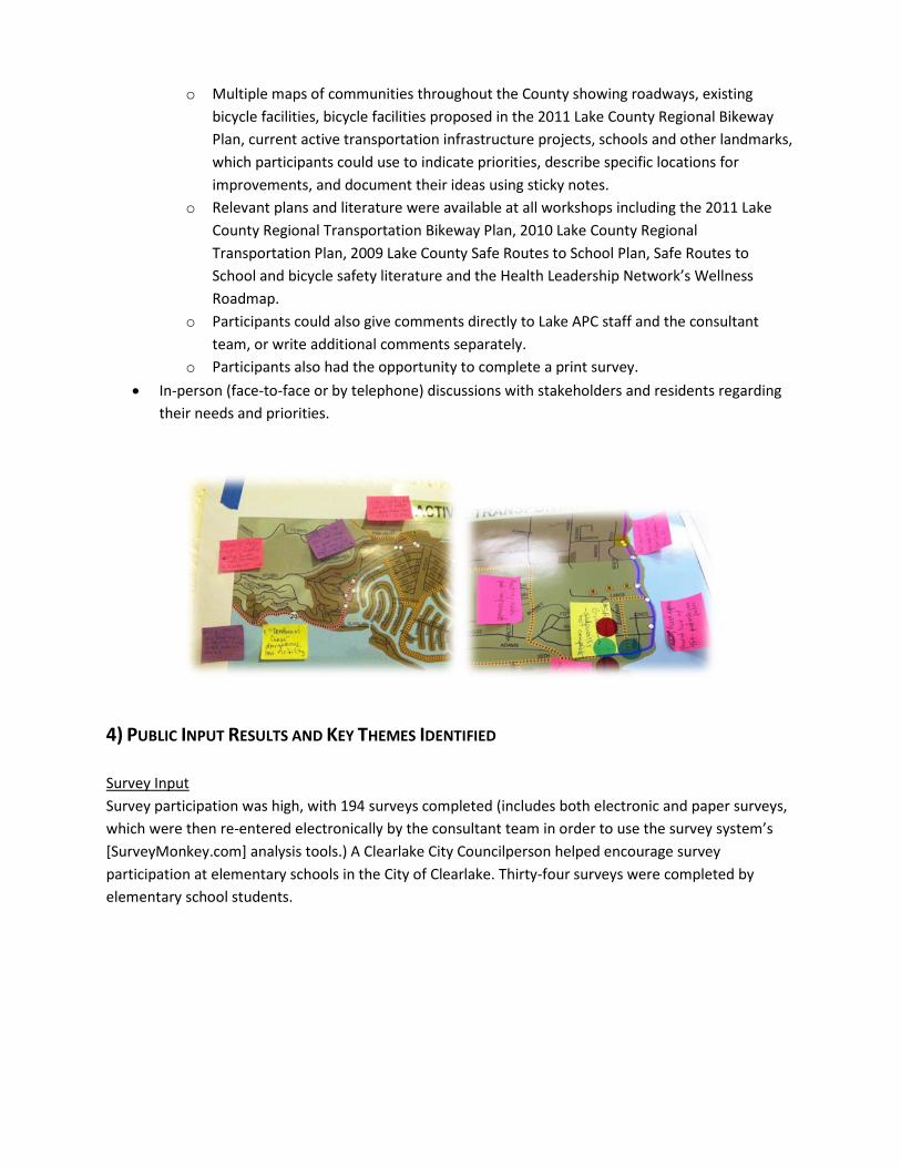
o Multiple maps of communities throughout the County showing roadways, existing bicycle facilities, bicycle facilities proposed in the 2011 Lake County Regional Bikeway Plan, current active transportation infrastructure projects, schools and other landmarks, which participants could use to indicate priorities, describe specific locations for improvements, and document their ideas using sticky notes.
o Relevant plans and literature were available at all workshops including the 2011 Lake County Regional Transportation Bikeway Plan, 2010 Lake County Regional Transportation Plan, 2009 Lake County Safe Routes to School Plan, Safe Routes to School and bicycle safety literature and the Health Leadership Network’s Wellness Roadmap.
o Participants could also give comments directly to Lake APC staff and the consultant team, or write additional comments separately.
o Participants also had the opportunity to complete a print survey. • In-person (face-to-face or by telephone) discussions with stakeholders and residents regarding
their needs and priorities.
4) PUBLIC INPUT RESULTS AND KEY THEMES IDENTIFIED Survey Input Survey participation was high, with 194 surveys completed (includes both electronic and paper surveys, which were then re-entered electronically by the consultant team in order to use the survey system’s [SurveyMonkey.com] analysis tools.) A Clearlake City Councilperson helped encourage survey participation at elementary schools in the City of Clearlake. Thirty-four surveys were completed by elementary school students.

A breakdown of survey responses by place of residence:
Where do you live? Response
Count Clearlake 92 Lakeport 42 Kelseyville 10 Hidden Valley Lakes 9 Rivieras 8 Clearlake Oaks 7 Lower Lake 7 Cobb 3 Lucerne 3 Upper Lake 3 Big Valley 2 Nice 2 Middletown 1 Glenhaven 1 Clearlake Peninsula 1 Scotts Valley 1
Survey respondents ranged in their responses to how many days per week they currently walk or bike for transportation purposes: 56.3% of respondents did not utilize active transportation, 26% utilized active transportation 1-3 days a week, and 15.1% walked or biked for transportation 4-7 days a week. The majority of survey respondents did not regularly utilize active transportation in Lake County – perhaps due to barriers this Active Transportation Plan is hoping to address.
Survey respondents indicated many reasons for walking and biking as part of their routine; however, health, exercise (63.6%) and recreation (41%) appear to be the top reasons versus for active transportation purposes. Close to 6% of respondents indicated they walk or bike to/from public transit stops, 14.5% commute to school and 10.4% utilize walking or biking to commute to work.
Lake County residents surveyed indicated a range of distances they were willing to commute by walking or biking, with 35.7% willing to commute over two miles – a range typically seen as a limit to regular walk/bike commuting.
Respondents indicated that there are many barriers that prevent them from walking and biking more regularly.

The table below details responses to barriers to walking and biking:
Answer Options Response Percent
Not enough sidewalks 43.0% Concerns about traffic 40.3% Time constraints 39.8% Not enough bicycle lanes 39.8% Destinations are too far 38.2% Poor or no pavement 37.6% Weather conditions 24.7% Concerns about crime/ personal safety 22.0% Need to carry things 21.5% Other (please specify) 20.4% Too many hills 16.7% Don't own a bicycle 11.3% Not enough bicycle parking 7.5% Need to link trips 6.5% Lack of interest 3.2% Too physically demanding 2.7% Disability 2.2% Not wheelchair friendly 1.1%
Workshop Input Workshop turnout was rather low, but input from those who did attend was plentiful, specific and valuable. This input (outside of surveys, which were also completed by many individuals at the workshops) included written comments on maps and posters and verbal comments captured by consultant team and Lake APC staff. Types of feedback that were received included people’s general feelings about active transportation options (or lack thereof) in their communities, key locations for infrastructure improvements, what types of improvements would be most appropriate, and preferences for non-infrastructure strategies. For a complete list of all comments from the maps and strategy posters utilized during the workshops, survey responses, and other input, see Appendices 1-3.
Method for Identifying Key Themes Participants in the workshops were asked to select the strategies or improvement locations (from both maps and strategy posters) that were most important to them. They were not asked to consider feasibility, complexity, cost, or any other factors in making their selection – only their own personal priorities and local knowledge. Participants indicated their top 3 most important/ most needed improvements or strategies using sticky dots or hash marks with marker. In some cases, individuals also wrote “high priority” or “very important” next to their choices. In instances where, when transcribing the map and strategy poster input, the consultant team observed more than 2-3 sticky dots/ hash marks OR when individuals wrote down the exact same location/ strategy multiple times, it was noted as “high priority” in the spreadsheet cataloging the input (see Appendices 1-2). Additionally, the surveys resulted

in a number of key themes emerging about what people felt were the greatest needs for themselves and their families, and where walking and bicycling could be improved in their communities. This is a summary of the key themes that emerged, in the opinion of the consultant team, after reviewing all the input received.
Infrastructure Improvements by Geographic Location Clearlake
• The greatest number of people indicated that a roundabout was desired at Dam Road where the Walmart is located.
• Pedestrian-activated crossing light desired at: Olympic across from Post Office, near all schools, along Highway 53, and at Austin Park across Lakeshore from the bathrooms to the park and playground.
• Rapid flashing beacon desired at Austin Park. • Multiple locations for potential bulb-outs listed at specific intersections (see Appendix B.) • Signage and other safety improvements are needed to address limited sight distance at blind curves
(vertical & horizontal), especially at Lakeshore Drive and Colusa. • Both traditional and creative sidewalks are desired nearly everywhere in Clearlake, with a particular
emphasis on: accessing parks (Austin, Highland and Redbud Parks), schools, along Lakeshore Drive,
on Rumsey to Olympic to access the senior center, along Highways 53 and 29, and in the Avenues (40th Street, 32nd Street and 18th Avenue.)
• Bike lanes are desired throughout Clearlake on arterials and collector streets. • Street sweeping of bike lanes and shoulders desired throughout Clearlake. • Three routes are recommended for improvements to create a bike route loop: Burns Valley Road,
Lakeshore Drive, and Old Highway 53. • Bike boulevards are a preference in residential neighborhoods, and could be demarcated during
road maintenance and improvements. • A colorized shoulder is desired along old Highway 53, Lakeshore Drive, Olympic, Highway 20, and
Highway 29 (especially “Glasgow grade”.) • Bike parking is desired at Highlands Park, Austin Park and City Hall. • Bike repair stations are desired at Austin Park (where there is a BMX park/ skate park) and, to a
lesser degree, at the Burns Valley Strip Mall near the Safeway store. • A bike share program is desired for lakefront areas.
Lucerne/ North Shore Communities
• The Bridge Arbor Road/Rodman Slough Bridge proposed widening project was identified by numerous individuals as their number one priority for active transportation improvements. This would include an access bridge below the confluence for the wet months, biking/ hiking on levees with easements from Robinson Rancheria and rice farmers, and other coordination amongst smaller private property owners.
• Safety improvements were requested for “Deadman’s Curve” (at Hillside & SR 20) to address inadequate sight distance at the intersection. Bike lanes desired on 13th Avenue in Lucerne.
• A bicycle repair station is desired near the college in Lucerne. • “Paper subdivisions” in Lucerne and Clearlake Oaks were noted as roads that could be alternate
routes to Highway 20 for cyclists. • Desire for increase in number of traffic stops or signals on Highway 20 to discourage truck traffic and
direct trucks to Highway 29 instead. • Opportunities for recreational use: trail easements from Paradise Cove west of Clearlake Oaks to
Mendocino National Forest, High Valley Road north from Clearlake Oaks for mountain bikes, Soda Bay Road and Point Lakeview Road.

Lakeport/ North of Lakeport
• Desire for signage on 11th to watch for pedestrians and cyclists. • Plentiful interest in sidewalks, colorized shoulders and other pedestrian improvements in the
following areas: 11th Street, on Martin Street from fairgrounds to downtown, Bevins, filling gaps on Main Street and High Street, near Mendocino College (College to Main Street along Parallel Road), all along Lakeshore Drive, Park, Hartley Road, and completing sidewalks to schools.
• Bike path between Lakeport and Kelseyville garnered lots of interest. • The Bridge Arbor connection (north of Lakeport to north shore) was well-supported in Lakeport
also. • Recreational trail opportunities exist along levees and Rodman Slough. • Bike route desired linking Scotts Valley Road, Highways 29 and 20, and Hendricks Road – popular
but dangerous for cyclists. See Appendices 1-3 for additional detail. • Roundabout at the intersection of Lakeport Blvd and South Main. • Street lights noted as a need on Lakeshore Drive. • Crosswalks needed along 11th Street, High Street and Lakeshore Blvd. • Interest was expressed in support of a bike share program for downtown Lakeport. • Safe Routes to Schools improvements strongly desired by residents.
Middletown
• Significant interest in continuing the momentum from the Middletown Multiuse Path by continuing path and traffic calming into downtown on Highway 29.
• Need for traffic calming on Central Park and Santa Clara – possible traffic circle location. • Interest in a gravel path for pedestrians and equestrians along Barnes, Santa Clara and Central Park
to link to the horse arena – many children use this route both walking and on horseback. • Raised crosswalk – at new school off of Sunset, Park and School streets. • Signal timing concerns exist where traffic backs up at Highway 29 and Wardlaw (linked to arrival/
dismissal times for school and parent drop-off) • Interest in a path from Middletown to Hidden Valley Lakes.
Other Lake County Communities
• Kelseyville – Need pedestrian improvements to schools on Live Oak and to nearby park, where many children walk and cross Highway 29, as well as safer crossing at Bell Hill Road and accompanying signage. There are maintenance needs on Gross Road (which connects to Live Oak.)
• Multiple people noted that there is a great need for a bike lane on Bottle Rock Road in Cobb. • Multiple people desired a bike route on Sulphur Bank Road. • Traffic calming desired in the Soda Bay area.

Regional/ County-wide Infrastructure Improvements
• Plentiful interest in a separated bike/ pedestrian trail that circumnavigates the lake. • Wide, bright fog lines are needed throughout the County for safety of all roadway users. • Improved infrastructure around schools is a significant interest County-wide. • Wayfinding signage desired for entire County to indicate walking and biking routes, places of
interest, parks. • Plentiful interest in having mileage for trails/ paths/ routes marked or indicated so those who are
using a trail to meet their physical health goals can gauge the distance traveled. • Cycle tracks that are painted/ colorized in a contrasting color (green or red) are desired in towns
throughout the County. • Bus shelters and benches are desired throughout the County, particularly in locations where
nothing is currently available – rural locations, Clearlake Oaks, where seniors are frequently using transit, at colleges and shopping centers.
• Interest in “gateway” designs that slow traffic and delineate communities. • Multiple people indicated that maintenance of roadways and shoulders is a key concern, and that
shoulders should be maintained and paved like the roadway. Also, the presence of ditches immediately next to the roadway is a hazard.
Non-infrastructure Key Themes
• County-wide, bicycle and pedestrian safety campaigns were frequently cited as a need for both youth and adults.
• Youth safety equipment and riding skills desired County-wide. • Land use and planning for development that accommodates all modes of transportation are key
themes County-wide. • Plentiful interest and commitment in supporting a Safe Routes to Schools program in Lakeport –
particularly at Giselman. • Code enforcement/ law enforcement needs frequently identified – people indicated that there were
loose dogs that prevented them from biking/ walking (especially in the area from Lakeport north) and that they had public safety and crime-related fears.
• Safety campaigns and signage would be helpful paired at highway entrances. • Enhanced enforcement desired throughout the County, but with an emphasis on schools (Pomo
Elementary and Burns Valley School specially noted) as well as areas of Clearlake such as 35th Avenue and Phillips Avenue.
Access to lakeside beaches in Clearlake is likely not only an infrastructure need – this may require political leadership and partnerships with local landowners and businesses to achieve.
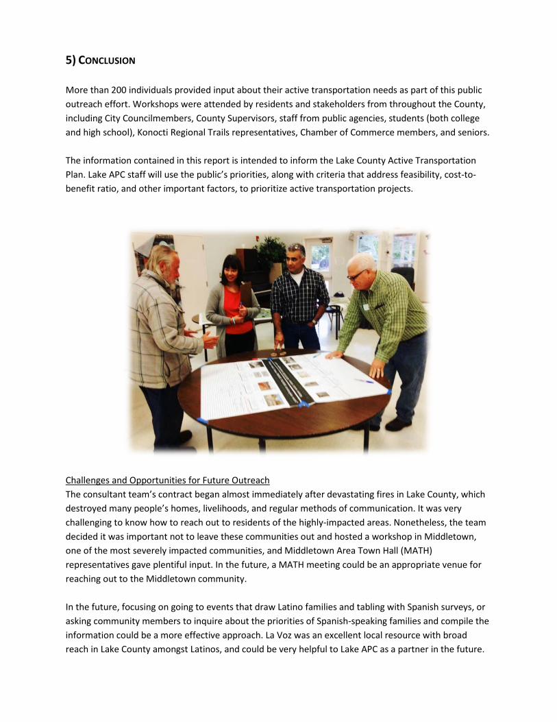
5) CONCLUSION More than 200 individuals provided input about their active transportation needs as part of this public outreach effort. Workshops were attended by residents and stakeholders from throughout the County, including City Councilmembers, County Supervisors, staff from public agencies, students (both college and high school), Konocti Regional Trails representatives, Chamber of Commerce members, and seniors. The information contained in this report is intended to inform the Lake County Active Transportation Plan. Lake APC staff will use the public’s priorities, along with criteria that address feasibility, cost-to-benefit ratio, and other important factors, to prioritize active transportation projects.
Challenges and Opportunities for Future Outreach The consultant team’s contract began almost immediately after devastating fires in Lake County, which destroyed many people’s homes, livelihoods, and regular methods of communication. It was very challenging to know how to reach out to residents of the highly-impacted areas. Nonetheless, the team decided it was important not to leave these communities out and hosted a workshop in Middletown, one of the most severely impacted communities, and Middletown Area Town Hall (MATH) representatives gave plentiful input. In the future, a MATH meeting could be an appropriate venue for reaching out to the Middletown community. In the future, focusing on going to events that draw Latino families and tabling with Spanish surveys, or asking community members to inquire about the priorities of Spanish-speaking families and compile the information could be a more effective approach. La Voz was an excellent local resource with broad reach in Lake County amongst Latinos, and could be very helpful to Lake APC as a partner in the future.

For future outreach efforts, ensuring that workshop locations are centrally located and highly accessible to pedestrians and transit routes would be very helpful. Also, the use of Senior Centers may be confusing to younger residents, who may have construed the events as something for seniors only. In the future, attending local meetings or large events that draw a crowd, including local government meetings, could be an effective way to reach Lake County residents.
Appendices
A. Map Comments from Workshops, B. Strategy Poster Comments from workshops and meetings (including feedback received by Lake
APC staff during workshops and a November 17, 2015 meeting in Clearlake) C. Survey Data, D. Survey in English and Spanish (paper version – electronic version was the same but formatted
differently) E. Strategy Posters (shown here in a small format – these were printed poster-size for workshops
and meetings)

Appendix A
Map Comments from Lake Active Transportation Plan Workshops Clearlake Workshop
• Redbud Park (just south of Lakeshore Drive where it turns east) – open the beaches so people can walk along whole length
• Highway 53 and 29 – Need colorized shoulders and ped facilities as there are a lot of pedestrians from the schools
• Need a roundabout at Dam Road where the Walmart is located • Need better pedestrian crossings of Highway 53. A lot of people dash across highway now. • Burns Valley would be a good country road cycling alternative • Path or bike lane on Rumsey back to Olympic would be great for seniors to walk on from the
senior center • Colusa Street (off Lakeshore) – there is a blind hill and need a warning sign with logo/image • Need speed bumps on Arrowhead Road! • Red shoulder on Highway 20! • Pomo Elementary not shown on the map
o Needs a bike lane parallel to Pomo as it is too dangerous • There is a public horse arena in Middletown west of Santa Clara
Lucerne Workshop
• Upper Lake area o Number 1 priority – Bridge Arbor Road for a bicycle/ped facility [two checks next to this] o Widen Rodman Slough Bridge – a lot of people cross the road just west of the existing
bridge. Work here with the Buddhists to make a pedestrian connection towards Nice. o Need a bridge below the confluence. But it is dry 5 months of the year. o Biking/hiking on levees + need easements from Robinson Rancheria, rice farmers and
small amount of property easements • Lakeport and north
o There are many loose dogs along the Westlake area…code enforcement issue o Scotts Valley Road from Blue Lakes to Lakeport is a big road cycling route but it is very
dangerous • Clearlake area
o Sulphur Bank Road northeast of Clear Lake is a poor quality road and is a deterrent to cycling
o Ride route 10 then route 11 in Clearlake just for the experience [are these KRT routes?]

North Shore
o Paradise Cove west of Clearlake Oaks…across is Paradise Ranch. There could be trail easements from here into Mendocino National Forest
o High Valley Road from Clearlake Oaks north would be great to advertise for mountain bikes
o On Highway 20 – Deadman’s Curve – where Hillside meets the 20 is very dangerous and has low visibility
o There is a lot of walking along Highway 20 between Glenhaven and downtown Clearlake Oaks. People walk on the rock guardwall.
o Need a walking loop in Clearlake Oaks from the school to park and back. Use Mountain View paper subdivision and make improvements on High Valley.
o Need traffic control on Highway 20 like traffic stops or signals to discourage truck traffic and encourage the truck traffic on Highway 29 instead
o Acknowledge Bartlett Springs to High Valley road could be an escape route/ alternative route if Highway 20 closed.
o Focus on trails around communities. o Paper subdivisions in Clearlake Oaks and Lucerne – these roads could be alternative
routes to Highway 20. County should accept these road right-of-ways into their system so the roads can serve as trails and alternative routes.
• Soda Bay area o Speeds too high along Soda Bay Road. Need traffic calming. o Point Lakeview Road (219) east of Clearlake Riviera has a lot of cyclists and great views
but needs a bike lane to be safer to cyclists. Also Soda Bay road.
Lakeport Workshop
• School area in north Lakeport o SRTS project at Giselman as sidewalks are not complete and this is the main route to the
schools in Lakeport (received 4 dot votes) o Hartley Road needs pedestrian improvements o Lakeshore Drive just east of the schools has a road repair project planned with the
addition of 4ft pedestrian path • Near Mendocino College
o Priority for ped improvements – Mendocino College to Main Street along Parallel Road o Need crosswalks improved at intersections of 29, 175, Parallel and 503/Soda Bay Road
• North Lakeport to Upper Lake o Bridge Arbor connectivity for bike/ped (received 2 dot votes) o Also recreational trails along levee, Rodman Slough o East of Rodman Slough the roadway falls off the shoulder and into ditch - not good for
bikes o Need sidewalks and bike lanes all the way down Lakeshore Drive o Need sidewalks and bike lanes on Park

o Hill Road used a lot by recreation walkers/bikers o Lakeshore Drive needs better maintenance of existing bike lanes, especially on the west
side o Need street lights on Lakeshore Drive
• Kelseyville o Live Oak and Highway 29 – need pedestrian improvements on Live Oak to the schools. A
lot of kids walk here and cross the highway. o Peds and cyclists cross over Highway 29 at Bell Hill Road which can be dangerous. Need
signage? o A park is also located near the schools shown on the map o Gross Road (connecting Live Oak and __) needs to be better maintained
• Other locations for improvements o Bike lane needed asap on Bottle Rock Road in Cobb (received two dot votes) o Scotts Valley needs bike lanes o Sulphur Bank Road would be a great ride to develop into a bike route (received two dot
votes) o Narrow shoulder on Soda Bay Road around Little Borax Lake o Highway 20 – make sure to pave driving lanes and shoulder at the same time during
repaving and maintenance o Traffic signals need loops to detect bikes at Highland Springs o Why are sidewalks being taken out at Highway 29 and Highland Springs?
Middletown Workshop
• Prioritize trail, bicycle connectivity around entire lake • Gigi’s KRT priorities by region • Now that the Middletown Multiuse Path has been funded from the Rancheria, next priority
should be a path and traffic calming from the end of the path into downtown on Highway 29 • Traffic calming needed on Central Park and Santa Clara as people speed through here
o Could include a traffic circle at Santa Clara and Lake o Also could include a gravel path for walking and horse along Barnes and down along
Santa Clara and Central Park to the horse arena. Many kids ride horses from north of town near the school down to the arena.
• Ensure the 6ft fence along Big Canyon is not rebuilt during the fire recovery. This fence blocked visibility near the school.
• Would be great to have an alternative to the highway connecting Barnes to Santa Clara • There should be a raised crosswalk at the new school (off of Sunset, Park and School streets) • There are signal traffic issues as traffic backs up at 29 and Wardlaw and perhaps need improved
arrival and dismissal area at the school

Appendix C
List of Projects by Jurisdiction

Proposed Bikeways for the City of Lakeport Roadway/Corridor Begin Point End Point Length Class Priority
11th Street City Limits North Main Street 0.89 II H 20th Street Alden Ave North High Street 0.66 II H Lakeport Blvd Parallel Drive South Main Street 0.57 II H Martin Street City Limits South Main Street 0.80 II H North High Street Clear Lake Ave Eleventh Street 0.07 II H Parallel Drive Hwy 175 Lakeport Blvd 1.28 II H South Main Street Lakeport Blvd First Street 0.53 II H South Main Street Lakeport Blvd/K St City Limits 0.75 II H
Proposed Sidewalks for the City of Lakeport Roadway/Corridor Begin Point End Point
1st Street Main St High St Fairview Way Hillcrest Dr Green St Forbes 1st St Martin Forest Dr Hillcrest Dr Loch Dr Giselman St Robles Dr Lange St High 1st St Martin Hillcrest Terrace Dr Loch Dr Martin Bevins Brush Sayre Begin Point Giselman St Terrace Hillcrest Dr Forest Dr
Proposed Bikeways for the City of Clearlake Roadway/Corridor Begin Point End Point Length Class Priority
Austin Ave Lakeshore Drive Old Hwy 53 1.00 II H Burns Valley Road Bowers Ave Olympic Drive 0.25 II M Country Club Drive Sulphur Bank Road Lakeshore Drive 0.27 II L Dam Road Lake Street SR 53 0.56 II H Dam Road Extension Dam Road 18th Ave 0.52 II M Lakeshore Drive Olympic Drive City Limits 3.18 II L Olympic Drive Lakeshore Drive Pine Street 0.23 II H Phillips Ave 40th Ave 18th Ave 1.00 II H Pine Street Olympic Drive Austin Road 0.12 II M

Proposed Sidewalks for the City of Clearlake Roadway/Corridor Begin Point End Point
18th Ave SR 53 Boyles Arrowhead Toyon Ciwa Austin Cottonwood Redwood Boyles 18th Ave 29th Ave Division Lakeshore Pine Huntington Lakeshore Arrowhead Olive Austin Walnut Pomo Nanake Arrowhead Walnut Pine Madrone
Proposed Bikeways for the Shoreline Communities Roadway/Corridor Begin Point End Point Length Class Priority
Hwy 20 Sulphur Bank Rd (Clearlake Oaks)
Nice Lucerne Cutoff Roundabout 17.34 II H
Proposed Sidewalks for Clearlake Oaks Roadway/Corridor Begin Point End Point
State Route 20 Shaul Road Butler Ave State Route 20 Keys Blvd Foothill Blvd Foothill Blvd Hwy 20 Oak Street New Alignment Hwy 20 1st Street
Proposed Bikeways for Cobb Roadway/Corridor Begin Point End Point Length Class Priority
Hwy 175 Emerford Rd Snead Drive 0.09 I M

Proposed Bikeways for Kelseyville Roadway/Corridor Begin Point End Point Length Class Priority
East Highland Springs Rd Adobe Creek Rd Highland Springs Rd 2.31 I L
Gross Cutoff Kelsey Creek Dr Live Oak Dr 0.24 I M Gaddy Ln Gunn St/Loasa Rd State St 0.58 II H Gaddy Ln State St Soda Bay Rd 2.11 II M
Highland Springs Rd Bell Hill Rd Big Valley Rd 3.58 II M
Hwy 281 Soda Bay Rd/Konocti Bay Rd Hwy 29 3.02 II L
Main St Merritt Rd/Gaddy Ln State St 0.81 II H Main St State St Konocti Rd 0.18 II H
Merritt Rd Big Valley Rd Gunn St/Loasa Rd 0.19 II M Park Dr Soda Bay Rd Lakeside Park 1.08 II M
Soda Bay Rd Big Valley Rd Clear Lake State Park 5.11 II H Soda Bay Rd South Main St Big Valley Rd 1.11 II H
Proposed Sidewalks for Kelseyville Roadway/Corridor Begin Point End Point
Konocti Cole Creek Bridge Oak Hills Ln
Proposed Bikeways for Lakeport North Roadway/Corridor Begin Point End Point Length Class Priority
North Lakeport Lakeshore Blvd Nice-Lucerne Cutoff 1.43 I M Hill Road Scotts Valley Road Hill Road East 0.27 II L Lakeshore Blvd 0.4 mi N. of Park Way Nice-Lucerne Cutoff 3.16 II H Martin Street Riggs Road City Limits 1.40 II M
Nice-Lucerne Cutoff Westlake Road Nice-Lucerne Cutoff (Abandoned) 1.61 II M
Riggs Road Martin Street Scotts Creek Road 1.02 II M Scotts Valley Road Hill Road Hwy 29/11th Street 0.49 II M South Main Street Soda Bay Road City Limits 0.49 II H

Proposed Sidewalks for Lower Lake Roadway/Corridor Begin Point End Point
Lake St Main St Lower Lake Elementary
Proposed Bikeways for Lucerne Roadway/Corridor Begin Point End Point Length Class Priority 13th (Castle Drive) Hwy 20 Country Club Drive 0.21 II H
Proposed Sidewalks for Lucerne Roadway/Corridor Begin Point End Point
9th Ave SR 20 Country Club 10th Ave SR 20 Country Club 14th Ave SR 20 Country Club 15th Ave SR 20 Country Club 16th Ave SR 20 Country Club 17th Ave SR 20 Country Club Country Club 3rd Ave 9th Ave
Proposed Bikeways for Middletown Roadway/Corridor Begin Point End Point Length Class Priority
Hwy 175 Dry Creek Cutoff Hwy 29 1.47 I M St. Helena Creek Rd. Wardlaw Street Hwy 29 0.27 I L Hwy 29 Hartmann Road Young Street 4.00 I/II H Hwy 29 Perry’s Market Central Park Road 0.43 II H Hwy 29 Rancheria Road Napa County Line 4.14 II L
Proposed Sidewalks for Middletown Roadway/Corridor Begin Point End Point
Coyote Valley Road Hartmann Coyote Valley Elementary School Mountain Meadow N Mountain Meadow S Hartmann
Proposed Bikeways for Nice Roadway/Corridor Begin Point End Point Length Class Priority Nice-Lucerne Cutoff
(Abandoned) Nice Lucerne Cutoff Lakeshore Blvd (Nice) 0.44 I H
Lakeshore Blvd Nice-Lucerne Cutoff (Abandoned) Lakeshore Blvd (Nice) 0.99 II M

Proposed Bikeways for the Rivieras Roadway/Corridor Begin Point End Point Length Class Priority
Point Lakeview Road Hwy 281 Hwy 29 6.89 II M Soda Bay Road Clear Lake State Park Hwy 281 7.49 II M
Proposed Sidewalks for the Rivieras Roadway/Corridor Begin Point End Point
Bel Air All All Del Monte All All Fairway Larkspur Bel Air Monte Cristo All All Monterey All All Sierra All All Sunset Ridge Pebble Beach Way Fairway
Proposed Bikeways for the Upper Lake Roadway/Corridor Begin Point End Point Length Class Priority
Bridge Arbor Bikeway (Alt #1) Hwy 20/Main Street Bridge Arbor Road 1.16 I H
Bridge Arbor Bikeway (Alt #2) Hwy 20/Main Street Bridge Arbor Road 1.57 I M
Proposed Sidewalks for Upper Lake Roadway/Corridor Begin Point End Point
1st St Government St 176 feet W of Clover Valley Rd 2nd St Main St 324 feet W of Clover Valley Rd Government St Melody Ln 1st St

Appendix D: Weighting System
Project Attribute 0 Points 1 Point 2 Points 3 Points High volume of bike/peds <12 per day 6 - 10 at peak hour 11 -50 at peak hour 50+ at peak hour High volume of traffic 0 - 200 201 - 2,000 2,001 - 8,000 >8,000
High speed corridor 0 -25 mph 26 - 40 mph 41 - 55 mph >55 mph
Accident history 0 reported injury severe injury fatality
Close to schools 2+ miles 2 - 1 miles 1 - 0.5 miles <0.5 miles
Close to transit 2+ miles 2 - 1 miles 1 - 0.5 miles <0.5 miles
Bike improvement Class III Class II Class II with Amenities Class I or IV
Ped improvement 0 Striping, ADA Safety Countermeasures Grade Separation
Close to Senior Center 2+ miles 2 - 1 miles 1 - 0.5 miles <0.5 miles
Disadvantaged Community 0 Criterion 1 Criterion 2 Criteria Severe Disadv.
Close to activity center 2+ miles 2 - 1 miles 1 - 0.5 miles <0.5 miles
Gap closure 0 Public Input Plan Recommendation Leveraged Project
Public health benefit 0 Public Input Plan Recommendation Leveraged Project
Public support 0 Public Input Plan Recommendation Feasibility Study
Includes alternatives 0 Conceptual Sketch-level Feasibility Study
Non-infrastructure 0 <5% of Budget School Programs Public At-large
Planning 0 Public Input Plan Recommendation Feasibility Study
Leveraged Funds 0 1% - 10% 11% -33% >33%
No alternate routes Indirect Public Roads Freeway-Expressway Unimproved RoW Public Land
Exceeds design standards 0 Aesthetic Value Safety Value <-Multiple Values
For the Adjusted Score, divide the weighted score by 6 to get a number between 0 and 10
1. Accident History over most recent 5-year period
2. Class II with Amenities includes end of trip bike facilities or proven safety countermeasures 3. Disadvantaged Community criteria established by the CTC

LAKE COUNTY/CITY AREA PLANNING COUNCIL TAC STAFF REPORT
TITLE: Active Transportation Program Update DATE PREPARED: September 8, 2016 MEETING DATE: September 15, 2016
SUBMITTED BY: Phil Dow, Transportation Planning Principal
BACKGROUND:
Due to ongoing funding shortfalls, the only consistent transportation funding available in 2016 is through the Active Transportation Program (ATP) administered by the California Transportation Commission. Cycle 3 of the competitive ATP is underway. The pertinent schedule for the Statewide and Small Urban/Rural programs, within which our agencies compete, is as follows: Applications Due to the CTC: June 15, 2016 CTC Staff Recommendations: October 28, 2016 CTC Adoption: December 8, 2016 Agencies within Lake County submitted only one ATP application in Cycle 3. A summary of this project application follows:
1. City of Lakeport: Hartley Street Safe Route to School Project Project will enhance the safety of students walking to and from school by installing sidewalks, curbs, and gutters along Hartley Street, a rural road with steep vertical and horizontal curves, limited sight distance and steep drop-offs. Retaining structures and fencing are needed in the steepest roadway sections. The project is along Hartley Street between 20th Street and the northernmost City Limits. Project cost is $1.87 million, with $22,000 local match to be provided by APC.
APC planning staff teamed with Lakeport staff to prepare and submit this application on behalf of the City of Lakeport. Loretta Ellard learned from the Rural Counties Task Force that the CTC received 456 project applications in Cycle 3. Last year 617 applications were received for Cycle 2, and in Cycle 1, 740 applications were received. APC staff will likely learn of the California Transportation Commission staff recommendations prior to the October 28 deadline.
ACTION REQUIRED: None.
ALTERNATIVES: None identified.
RECOMMENDATION: None. This is for your information only.
Lake TAC Meeting: 9/15/16 Agenda Item: #4ai

Lake 20/53 Intersection Improvement ProjectPublic Open House – August 25, 2016
This safety improvement project proposes to improve the intersection of State Route (SR) 20 and SR 53 by constructing a roundabout.
Purpose and Need:
This safety project is needed to reduce collisions at the intersection of SR 20 and SR 53. The “Fatal plus Injury” collision rate for thissegment of highway is approximately 5 times the statewide average for similar facilities.
Safety Improvement:
The proposed roundabout is expected to reduce the total number of collisions by 28%. Additionally, collisions with injuries are expected to be reduced by 74%.
Truck Accessibility:
The project will be designed for industry standard trucks. A truck apron and mountable curbs will be used to accommodate oversized loads.
Right of Way:
Caltrans anticipates a need to acquire a total of 4.3 acres from 5 parcels.
Cost:
Construction $ 6,000,000.00 Right of Way Acquisition $ 170,000.00 Total $ 6,170,000.00
Lake TAC Meeting: 9/15/16 Agenda Item: #4aii

Lake 20/53 Intersection Improvement Project
Project Description:
The California Department of Transportation (Caltrans) proposes a safety improvement project in Lake County at the intersection of SR 20 and SR 53 by replacing the existing partially stop-controlled intersection with a roundabout. Three existing bypass lanes will be maintained by overlaying existing pavement. The project will construct the new circulatory roadway along with new approaches and exits.
A new frontage road will be constructed to collect the traffic from 8 parcels on the north side of SR 20. The crest vertical curve on SR 20 west of the roundabout will be lowered to improve stopping sight distance for vehicles westbound on SR 20. Left and right turn pockets will be constructed at the new intersection of SR 20 and the frontage road.
Project Schedule:
Project Milestone Milestone Date Approve Final Environmental Document September, 2016 Begin Right of Way Appraisals & Acquisitions November, 2016 Designed and Ready to Build February, 2018 Begin Construction Summer, 2018 Construction Complete Winter, 2019
Contact Information: For additional information, please contact Jaime Matteoli, Project Manager at (707) 441-2097 or [email protected].
Project Website: www.dot.ca.gov/dist1/d1projects/20-53

LAKE COUNTY/CITY AREA PLANNING COUNCIL TAC STAFF REPORT
TITLE: FY 17/18 Sustainable Transportation Planning Grant DATE PREPARED: September 8, 2016 MEETING DATE: September 15, 2016
SUBMITTED BY: James Sookne, Project Manager
BACKGROUND:
On August 26, 2016, Caltrans released the Call for Applications for the Fiscal Year 2017-18 Sustainable Transportation Planning Grant Program. There is approximately $9.3 million available for transportation planning projects statewide. Overarching objectives for the grant program have been identified to ensure consideration of these major efforts in transportation planning, including: Sustainability, Preservation, Mobility, Safety, Innovation, Economy, Health, and Equity. The intent of the program remains the same. Although dedicated funding no longer exists for Environmental Justice, Community-Based Transportation Planning, and Transit Planning, these areas are still eligible for funding under the new Grant Program. Caltrans still provides transportation planning grants to promote a balanced, comprehensive multimodal transportation system; however, the program has been revised to reflect current goals emphasizing more transportation planning efforts that promote sustainability. These grants may be used for a wide range of transportation planning purposes that address local and regional transportation needs and issues. The implementation of these grants should ultimately lead to the adoption, initiation, and programming of transportation improvements. Below is the schedule for FY 17/18 Grant Awards:
• August 26, 2016 – Release Call for Applications • November 4, 2016 at 5 PM – Application Deadline • December – District Grant Application Review/Ranking • January/February 2017 – HQ Grant Committee Review/Funding Recommendations • February/March 2017 – Management Approval of Committee Recommendations • March/April 2017 – Send Preliminary Notifications to All Applicants • April 2017 – Send Conditional Award Letters with State Budget Contingency • July/October 2017 – Grantees May Begin Work, Pending State Budget Approval
APC staff will be available to assist local agencies with grant applications if necessary.
ACTION REQUIRED: None.
ALTERNATIVES: None identified.
RECOMMENDATION: None. This is for your information only.
Lake TAC Meeting: 9/15/16 Agenda Item: #4ciii

Application Deadline November 4th at 5:00 PM
California Department of Transportation
Division of Transportation Planning
CALTRANS SUSTAINABLE TRANSPORTATION PLANNING
GRANT PROGRAM
FY 2017-2018
Grant Application Guide STRATEGIC PARTNERSHIPS
SUSTAINABLE COMMUNITIES


Table of Contents
Sustainable Transportation Planning Grant Program….…...……………………………..…... 1
Sustainable Transportation Planning Grant Summary Chart…….……………………….….. 5
General Information and Requirements……………………………………………………........ 6
Grant Program Overview……………………………………………………................................ 10
Application Preparation….…………………………………………..………………................... 16
Application Submittal Instructions……………………………………………………... 17
Tips and Pointers for Writing a Successful Grant Application........................................ 18
Grant Application Checklist and Sample………………...………..………………….... 19
Scope of Work Checklist and Sample………………………..………………………… 29
Project Timeline Checklist and Sample………………………..…………………......... 35
Third Party In-Kind Valuation Plan Checklist and Sample…..…………………........... 37
Local Resolution Checklist and Sample……………………………………………....... 39
Caltrans District and Regional Agency Boundaries Map…………………................................ 41
Caltrans Sustainable Transportation Planning Grant District Contact List…..………........... 42
ADA Notice: For individuals with sensory disabilities, this document is available in alternate formats. For information call (916) 654-6410 or TDD (916) 654-3880 or write Records and Forms Management, 1120 N Street, MS-89, Sacramento, CA 95814.

[Intentionally left blank]

1
Sustainable Transportation Planning Grant Program The Sustainable Transportation Planning Grant Program was created to support the California Department of Transportation’s (Caltrans’) Mission: Provide a safe, sustainable, integrated and efficient transportation system to enhance California’s economy and livability. Current significant efforts were also considered during Grant Program development, such as:
California Transportation Infrastructure Priorities Vision and Core Concepts; State Smart Transportation Initiative Assessment and Recommendations; Caltrans Program Review Major Actions; California Transportation Plan (CTP) 2040 Vision and Goals; and, Smart Mobility 2010 Principles.
The Grant Programs Overarching Objectives were also identified to ensure consideration of these major efforts in transportation planning, including: Sustainability, Preservation, Mobility, Safety, Innovation, Economy, Health, and Equity. In addition, grant administration processes have been further streamlined and made consistent to benefit our partners and District grant managers. Most notable is the earlier release date of this Grant Application Guide, the earlier application deadline, and an earlier grant award announcement date. With this advanced process, grant recipients can anticipate starting project activities early in Fiscal Year (FY) 2017-2018, pending State Budget approval. The intent and amount of funding available for the Sustainable Transportation Planning Grant Program remains unchanged from previous years. Caltrans still provides transportation planning grants to promote a balanced, comprehensive multimodal transportation system that promotes sustainability and these grants may still be used for a wide range of transportation planning purposes that address local, regional, and interregional transportation needs and issues. The implementation of these grants should ultimately lead to the adoption, initiation, and programming of transportation improvements. The Caltrans Division of Transportation Planning provides the following transportation planning grants:
Strategic Partnerships Sustainable Communities for MPOs & RTPAs Sustainable Communities for Cities, Counties, Transit Agencies, and Tribal Governments
Integrating Goals and Objectives All grant applications must align with the Caltrans Mission, Grant Program Overarching Objectives, and the CTP 2040 Vision. The State and Federal goals provide the framework for the Strategic Partnerships and Sustainable Communities grants. A competitive grant application addresses and articulates how the project relates to the Caltrans Mission, Grant Program Overarching Objectives, CTP 2040 Vision, and multiple State and Federal goals. The Grant Specific Objectives on Page 14 indicate the specific purpose of each grant, and should also be considered when preparing an application. Overall, successful grant applications clearly demonstrate how the proposed project integrates the State and Federal goals and the Grant Program Overarching objectives.

2
State Transportation Planning Goals1 1. Improve Multimodal Mobility and Accessibility for All People: Expand the system and
enhance modal choices and connectivity to meet the State’s future transportation demands. 2. Preserve the Multimodal Transportation System: Maintain, manage, and efficiently utilize
California’s existing transportation system. 3. Support a Vibrant Economy: Maintain, manage, and enhance the movement of goods and
people to spur the economic development and growth, job creation, and trade. 4. Improve Public Safety and Security: Ensure the safety and security of people, goods, services,
and information in all modes of transportation. 5. Foster Livable and Healthy Communities and Promote Social Equity: Find transportation
solutions that balance and integrate community values with transportation safety and performance, and encourage public involvement in transportation decisions.
6. Practice Environmental Stewardship: Plan and provide transportation services while protecting our environment, wildlife, historical, and cultural assets.
Federal Transportation Planning Goals2 1. Support the economic vitality of the metropolitan area, especially by enabling global
competitiveness, productivity, and efficiency. 2. Increase the safety of the transportation system for motorized and non-motorized users. 3. Increase the security of the transportation system for motorized and non-motorized users. 4. Increase the accessibility and mobility of people and freight. 5. Protect and enhance the environment, promote energy conservation, improve the quality of life,
and promote consistency between transportation improvements and state and local planned growth and economic development patterns.
6. Enhance the integration and connectivity of the transportation system, across and between modes, for people and freight.
7. Promote efficient system management and operation. 8. Emphasize the preservation of the existing transportation system. 9. Improve the resiliency and reliability of the transportation system and reduce or mitigate
stormwater impacts of surface transportation. 10. Enhance travel and tourism. California Transportation Plan 2040 Vision California’s transportation system is safe, sustainable, and globally competitive. It provides reliable and efficient mobility and accessibility for people, goods, and services while meeting our greenhouse gas emission reduction goals and preserving the unique character of California’s communities.. This integrated, connected, and resilient multimodal system supports a thriving economy, human and environmental health, and social equity.
1 Source: California Transportation Plan 2040
2 Source: Title 23, United States Code, Section 134

3
Promoting Sustainable Communities in California Caltrans supports Senate Bill 375 (SB 375, 2008) Sustainable Communities Strategy (SCS) efforts. Applications should complement SCS efforts, if they exist in the geographical region. The SCS is a tool that is intended to help communities reduce transportation related greenhouse gas emissions and assist local and regional governments in creating sustainable communities for residents throughout the State. Information on SCS efforts can be found at: http://www.arb.ca.gov/cc/sb375/sb375.htm. Although most rural areas of the State are not subjected to SB 375/SCS requirements, Caltrans still promotes the development of sustainable communities in these areas of the State. Eligible rural agencies are strongly encouraged to apply for Sustainable Communities grants. Addressing Environmental Justice and Disadvantaged Communities3,4 Caltrans strives for environmental justice in all of its activities. In the past, low-income and minority communities bore many of the negative impacts of transportation projects. It is the goal of environmental justice to ensure that when transportation decisions are made, low-income and minority communities have a full opportunity to participate in the decision-making process, and they receive an equitable distribution of benefits and not a disproportionate share of burdens. Caltrans encourages eligible applicants to apply for Sustainable Communities grants to address transportation needs and deficiencies in disadvantaged communities. CalEnviroScreen Version 2.0 is used to verify the disadvantaged communities that will benefit from awarded grant projects. Information about environmental justice and disadvantaged communities can be found at: CalEnviroScreen Version 2.0: http://oehha.maps.arcgis.com/apps/Viewer/index.html?appid=dae2fb1e42674c12a04a2b302a080598 Desk Guide – Environmental Justice in Transportation Planning Investments: http://www.dot.ca.gov/hq/tpp/offices/ocp/documents/ej_titlevi_files/EnvironmentalJusticeDeskGuideJan2003.pdf Community Primer on Environmental Justice & Transportation Planning: http://www.dot.ca.gov/hq/tpp/offices/ocp/documents/ej_titlevi_files/EJ_Primer_4_10_WEB.pdf Complete Streets and Smart Mobility Framework Caltrans also supports complete streets and the Smart Mobility Framework (SMF). If applicable, Caltrans encourages applicants to consider the tools and techniques contained in the SMF as well as typical components of complete streets. Specifically, this might include how the project addresses components of community design, regional accessibility, place types, and priority activities to achieve smart mobility outcomes, community transition, and associated multimodal performance measures for the appropriate context of the problem. Information on these efforts can be found at: Complete Streets: http://www.dot.ca.gov/hq/tpp/offices/ocp/complete_streets.html SMF: http://www.dot.ca.gov/hq/tpp/offices/ocp/smf.html 3 Source: Desk Guide – Environmental Justice in Transportation Planning Investments (2003) 4 Source: Community Primer on Environmental Justice & Transportation Planning (2008)

4
Climate-Ready Transportation California’s six key climate change strategy pillars provides a framework for reducing California’s greenhouse gases emissions and increasing resiliency to the anticipated effects of global warming: (1) reducing today’s petroleum use in cars and trucks by up to 50 percent; (2) increasing to 50 percent our electricity derived from renewable sources; (3) doubling the efficiency savings achieved at existing buildings and making heating fuels cleaner; (4) reducing the release of short-lived climate pollutants; (5) managing farm and rangelands, forests and wetlands so they can store carbon; and, (6) updating the Safeguarding California Plan - California’s climate adaptation strategy. Climate change poses many threats to our communities’ health, well-being, environment, and property. Extreme weather, rising sea levels, shifting snowpack, among other impacts will touch every part of peoples’ lives in the next century. Planning key actions now will help lessen impacts and cope with changes. Government, at every level, must work together to safeguard our state by taking steps to reduce our own impacts and increase our resilience in the future. Executive Order B-30-15 specifically addresses the need for all of the state’s planning and investments to consider the exposures and risks from a changing climate, anticipating current and future impacts and disruptions that are likely to occur. The order establishes a California greenhouse gas emissions reduction target of 40 percent below 1990 levels by 2030, directs state government to take climate change into account in all planning and investment decisions, and employ full life-cycle cost accounting to evaluate and compare infrastructure investments and alternatives. It describes four guiding principles when making planning and investment decisions:
Priority should be given to actions that both build climate preparedness and reduce greenhouse gas emissions;
Where possible, flexible and adaptive approaches should be taken to prepare for uncertain climate impacts;
Actions should protect the state's most vulnerable populations; and Natural infrastructure solutions should be prioritized.
Safeguarding California – http://resources.ca.gov/climate/safeguarding/ California Climate Adaptation Planning Guide – http://resources.ca.gov/climate/safeguarding/adaptation_policy_guide/

5
Sustainable Transportation Planning Grant Summary Chart
GRANT FUND SOURCE PURPOSE WHO MAY APPLY LOCAL MATCH
Strategic Partnerships
Federal Highway Administration—
State Planning and Research, Part 1
Budget Federal funds $1,500,000
Grant Min $100,000
Grant Max MPOs $1,000,000, All others $500,000
Funds transportation planning studies of interregional and
statewide significance, in partnership with
Caltrans.
The following are eligible to apply as a primary applicant: Metropolitan Planning Organizations and
Regional Transportation Planning Agencies (MPOs/RTPAs)
The following are eligible to apply as a sub-applicant: MPOs/RTPAs Transit Agencies Universities and Community Colleges Native American Tribal Governments Cities and Counties Community-Based Organizations Non-Profit Organizations (501.C.3) Other Public Entities**
20% minimum (in non-federal funds or an in-
kind* contribution). The entire minimum 20%
local match may be in the form of an eligible in-
kind contribution. Additional local funds
above the minimum local match are desired.
Sustainable Communities
Federal Transit Administration (FTA), Section
5304
&
State Highway Account (SHA)
Budget Federal/State funds
$7,800,000
Grant Min $50,000
Grant Max MPOs $1,000,000, All others $500,000
Funds studies of multimodal
transportation issues having statewide,
interregional, regionalor local significance to assist in achieving the Caltrans Mission and
overarching objectives.
The following are eligible to apply as a primary applicant: MPOs/RTPAs Transit Agencies; Cities and Counties;
Native American Tribal Governments
The following are eligible to apply as a sub-applicant: MPOs/RTPAs Transit Agencies Universities and Community Colleges Native American Tribal Governments Cities and Counties Community-Based Organizations Non-Profit Organizations (501.C.3) Other Public Entities**
11.47% minimum (in cash or an in-kind*
contribution). The entire minimum 11.47% local
match may be in the form of an eligible in-kind
contribution.
* For in-kind contribution requirements, refer to Page 12 of this Guide. **
Public entities include state agencies, the Regents of the University of California, district, public authority, public agency, and any other political subdivision or public corporation in the State (Government Code Section 811.2).

6
General Information and Requirements This section provides a brief overview of the financial, subcontracting, and legal requirements pertaining to all grant programs. The content of this section should be notably considered in the development of grant applications as it lays the foundation for what to expect when applying for these grant funds. Upon award, grantees will receive more specific guidelines including administrative and reporting requirements. Accounting Requirements Grantees are required to maintain an accounting and record system that properly accumulates and segregates incurred project costs and matching funds by line item. The accounting system of the grantee, including its sub-applicants and subcontractors, must conform to Generally Accepted Accounting Principles that enable the determination of incurred costs at interim points of completion and provides support for reimbursement payment vouchers or invoices sent to or paid by Caltrans. Allowable project costs must comply with 2 Code of Federal Regulations (CFR), Part 200. It is the grantee’s responsibility, in conjunction with Caltrans District staff, to monitor work and expenses to ensure the project is completed according to the contracted Scope of Work and Project Timeline. Grantees must monitor work and costs to ensure invoices are submitted on a regular and timely basis (monthly or quarterly as milestones are completed). Grantees must communicate with their local Caltrans District Office to ensure any issues are addressed early during the project period. Indirect and Direct Costs Indirect costs require an Indirect Cost Allocation Plan (ICAP). For example, reproduction costs, computer rental and office supplies are considered indirect costs. However, if these costs are tied to a specific task or activity, they are considered direct costs. If a grantee, including sub-recipients and third party contractors/consultants, are seeking reimbursement of indirect costs, they must annually submit an ICAP or an Indirect Cost Rate Proposal (ICRP) to Caltrans Audits and Investigations for review and approval prior to reimbursement. An ICAP or ICRP must be prepared and submitted in accordance with 2 CFR, Part 200. For more information visit the following website: Indirect Cost Allocation Plan: http://www.dot.ca.gov/hq/audits/icap_icrp.html Due to the competitive nature of the grant award process, applications must include any indirect costs in the Project Timeline. Indirect costs can only be reimbursed if they are identified in the Project Timeline submitted with the initial application.

7
Eligible Activities and Expenses Direct costs must be used only for transportation planning-related activities. Please consult with Caltrans District staff for more information on whether costs are eligible for funding. Some examples of eligible costs include:
Data gathering and analysis Planning consultants Conceptual drawings and design Community surveys, meetings, charrettes, focus groups Bilingual services for interpreting and/or translation services for meetings
Travel Expenses Grantees may be eligible to claim travel expenses if they have been approved in the Scope of Work and Project Timeline. Travel expenses and per diem rates are not to exceed the rate specified by the State of California Department of Personnel Administration for similar employees (i.e. non-represented employees). For more information on eligible travel expenses, visit the following website:
Caltrans Travel Guide: http://www.dot.ca.gov/hq/asc/travel/
Ineligible Activities and Expenses Some activities, tasks, project components, etc. are not eligible under these grant programs, regardless of funding source. If an application has any of the following elements, it will be disqualified. Ineligible activities and expenses include:
Environmental studies, plans, or documents normally required for project development under the National Environmental Policy Act or the California Environmental Quality Act
Engineering plans and design specification work Project Initiation Documents (PIDs) Regional Transportation Plans (RTP) or updates to the RTP Economic development plans or studies Land use plans or studies General Plans or updates to elements Construction projects, such as the building of a facility, or maintenance Purchasing of office furniture, or other capital expenditures Decorations Acquisition of vehicles or shuttle programs Organizational membership fees Unreasonable incentives such as prizes for public participation Charges passed on to sub-recipient for oversight of awarded grant funds Other items unrelated to the project

8
Third Party Contracts The agreements between a grantee and a sub-recipient, consultant, or sub-consultant are often referred to as “third party contracts.” An eligible sub-applicant will be identified by an eligible applicant on the onset of the application. If a grantee or a sub-recipient is going to hire a consultant to perform work during the project, then proper procurement procedures must always be used. Grantees may use their agency’s procurement procedures as long as they comply with 2 CFR, Part 200 and Local Assistance Procedures Manual, Chapter 10. In addition, work can only be contracted if it has been stated in the applicant’s Scope of Work and Project Timeline. A grantee is fully responsible for all work performed by its sub-recipient, consultant, or sub-consultant. Caltrans solely enters into a contract directly with the grantee; therefore the grantee is responsible to ensure that all third parties adhere to the same provisions included in the contractual agreement between Caltrans and the grantee. All government funded consultant procurement transactions must be conducted using a fair and competitive procurement process that is consistent with 2 CFR, Part 200 and Local Assistance Procedures Manual, Chapter 10. All documentation of third party contract procurements must be retained and copies of all agreements must be submitted to Caltrans. For more information on third party contracting, visit the following links: 2 Code of Federal Regulations (CFR), Part 200 - http://www.ecfr.gov/cgi-bin/text-idx?tpl=/ecfrbrowse/Title02/2cfr200_main_02.tpl Local Assistance Procedures Manual: http://www.dot.ca.gov/hq/LocalPrograms/lam/lapm.htm Title VI Non-Discrimination Requirement Title VI of the U.S. Civil Rights Act prohibits discrimination on the basis of race, color, or national origin in programs or activities receiving federal financial assistance. Specifically Title VI provides the following:
No person in the United States shall, on the ground of race, color, national origin, religion, sex, age, or disability be excluded from participation in, be denied the benefits of, or be subjected to discrimination under any program or activity receiving financial assistance from the Federal government.
The Federal Highway Administration (FHWA) and the Federal Transit Administration (FTA) each have requirements that recipients of Metropolitan Planning federal funds must demonstrate continued compliance with Title VI. Compliance with Title VI includes conducting meetings in a fair and reasonable manner that are open to all members of a community. Compliance reflects not only the law, but is also a good policy that builds the kind of trust and information sharing upon which successful planning is done. Even where a city or county may not be receiving federal funding for transportation, the Civil Rights Restoration Act of 1987 also obligates that a city or county comply with Title VI, if it receives any other federal funding for any program. Caltrans is responsible for complying with Civil Rights requirements and for monitoring funding compliance of any sub-applicants. Grant recipients of federal funds, primarily Metropolitan Planning

9
Organizations (MPOs) and Regional Transportation Planning Agencies (RTPAs), are required to comply with FTA Circular 4702.1B, and must submit a copy of the agency’s governing board-approved Title VI Program. Caltrans staff will contact grantees to ensure this requirement is satisfied. Disadvantaged Business Enterprise Reporting Grant recipients of federal funds, primarily MPOs and RTPAs, are required to report any Strategic Partnerships and/or Sustainable Communities contracting opportunities that may involve Disadvantaged Business Enterprise (DBE) participation. DBE reporting is required twice a year: April 1st and October 1st. For details about DBE requirements, visit the Office of Regional Planning (ORP) DBE website at: http://www.dot.ca.gov/hq/tpp/offices/orip/DBE/DBE.html. Pre-Award Audit The Strategic Partnerships and Sustainable Communities grants are available in amounts up to $500,000 ($1 million for MPOs). However, any awarded grant in excess of $250,000 may require a pre-award audit. The pre-award audit is to ensure that recipients of state and federal funds maintain adequate financial management systems prior to receiving the funds. Pre-award audits may be required of new grantees, agencies that have not recently been audited, agencies that have undergone prior audits with significant weaknesses or deficiencies in their financial management systems, or those determined to be a higher risk to Caltrans. If a pre-award audit is needed, the local Caltrans District Office will contact the grantee to facilitate the appropriate action. This has the potential to delay the start of the project and applicants are encouraged to determine if the delay will hinder their ability to complete the project by the terms specified in the agreement. Additional Performance Considerations Previous grantee performance will be considered during the evaluation process. Applicants with a history of inadequate performance such as poor grant project management, failure to achieve grant project milestones, untimely invoice submittals, or an overall poor quality of the final grant product may be at a competitive disadvantage in the application review process. Grant funds may not be awarded to prior grant recipients with unresolved past grant performance issues. Additionally, applicants that have an excessive balance of or consistently relinquish any transportation funds administered by Caltrans Planning and/or have unresolved audit issues or findings will also be at a competitive disadvantage in the application review process. Applicants that have also failed to satisfy the required state and federal planning requirements, including submittal and administration of the Overall Work Program, Regional Transportation Plans, and Transportation Improvement Program, may not be awarded grants.
10
Award Terms Caltrans is committed to being an active partner. If awarded a grant, the applicant should include Caltrans District staff when planning both technical advisory and community meetings. In addition, Caltrans District staff will help to ensure that the approved Scope of Work, Project Timeline, and project funding will be maintained throughout the life of the contract. Applicants are also recommended to engage Caltrans District Staff throughout the entire grant life, when applicable. If an agency does not demonstrate adequate performance and timely use of funds, Caltrans may take appropriate actions, which can include termination of the grant. As stated in the previous section, inadequate performance by grantees, sub-recipients, or consultants may hinder the grantee’s ability to leverage future grant awards. Ownership Any technologies or inventions that may result from the use of these grants are in the public domain and may not be copyrighted, sold, or used exclusively by any business, organization, or agency. Caltrans reserves a royalty-free, non-exclusive, and irrevocable license to reproduce, publish, or otherwise use and to authorize others to use for public purposes. Grant Program Overview The Sustainable Transportation Planning Grant Program is both state and federally funded. The role of the Metropolitan Planning Organization (MPO) and Regional Transportation Planning Agency (RTPA) is to facilitate a fair and open competitive application and outreach process. For an MPO or RTPA to influence the applicant pool either formally or informally by pre-screening applications is contrary to both state and federal administration of these grant programs. Sub-applicants are encouraged to work far in advance of the application deadline with the appropriate MPO or RTPA to coordinate application development. It is also beneficial for sub-applicants to be informed of the appropriate MPO or RTPA process and schedule, as they may differ slightly from those of Caltrans. RTPAs residing within MPO boundaries should also coordinate application development with the MPO, as it is critical to ensure that proposed studies align with the RTP/SCS for the entire MPO region and do not duplicate efforts being applied for or already awarded to the MPO. Who May Apply – Strategic Partnerships Only MPOs and RTPAs that have a current Master Fund Transfer Agreement (MFTA) with ORP may apply directly for the Strategic Partnerships grants. Eligible sub-applicants include: MPOs and RTPAs, universities and community colleges, Native American Tribal Governments, cities and counties, community-based organizations, non-profit organizations (501.c.3), and public entities.

11
Who May Apply – Sustainable Communities Eligible primary applicants for the Sustainable Communities grants include: MPOs and RTPAs; transit agencies; cities and counties, and Native American Tribal Governments. Eligible sub-applicants include: MPOs and RTPAs, universities and community colleges, Native American Tribal Governments, cities and counties, community-based organizations, non-profit organizations (501.c.3), and public entities. For awarded grantees that do not have a current MFTA with ORP (i.e. cities, counties, transit agencies, Tribal Governments), Caltrans will contract directly with the primary grant recipients through the Restricted Grant Agreement (RGA) process. Project Start Dates All awarded grant funds must be programmed during the State’s 2017-18 Fiscal Year. The project start date depends on the method of contracting with Caltrans. For MPOs and RTPAs with a current MFTA, work may begin as early as July 2017. For other grant recipients that will undergo the RGA contracting process, work may begin as early as October 2017, assuming the grantee has received a fully executed contract and has been notified by Caltrans District Staff to begin work. It is important for applicants to reflect the estimated project start date in the Scope of Work and Project Timeline. Awardees are required to submit all supporting materials and a signed agreement or risk forfeiting the grant award. The following section provides the project timeline constraints for both methods of contracting with Caltrans. Restricted Grant Agreement Project Timeline Consider these dates when developing the Scope of Work and Project Timeline: October 2017
Anticipated start date, pending State Budget approval
February 28, 2020 Contract expires (no time extensions will be granted) Reimbursable work must be completed
April 28, 2020 All final invoices must be submitted to Caltrans for approval and reimbursement. This allows
Caltrans sufficient time to comply with the State Controller’s Office payment requirements. Master Fund Transfer Agreement Project Timeline (MPOs/RTPAs Only) Consider these dates when developing the Scope of Work and Project Timeline: July 2017
Anticipated start date, pending State Budget approval June 30, 2020
Project end date Reimbursable work must be completed

12
Final Request for Reimbursement A Final Request for Reimbursement must be filed no later than 60 days after the end of the
fiscal year to coincide with the submission of the Overall Work Program (OWP) Final Expenditure Report.
Overall Work Program (for MPOs/RTPAs Only) All MPOs and RTPAs must have the entire grant award and local match programmed in the Fiscal Year 2017-18 OWP no later than May 1, 2018. Approved grant projects must be identified as individual Work Elements in the current OWP and in future OWPs until the project is completed. Requests for Reimbursements Grant payments are made only as reimbursements. Invoices or Requests for Reimbursements (RFR) need to be submitted no more frequently than monthly or at a minimum quarterly. Grantees must pay sub-recipients and subcontractors prior to submitting a RFR to Caltrans. A one-time, lump sum RFR for the entire grant is not allowed. Local match (cash and third party in-kind contributions) must be expended on a proportional basis coinciding with each grant Work Element (MPOs/RTPAs only) and/or tasks in each RFR. The proportional expenditure of local match must be clearly identified in the Project Timeline. The minimum required local match (i.e., 11.47% or 20%) must be rendered during the invoicing period to which the matching requirement applies. The minimum required local match must also be satisfied with each RFR. Local Match Contribution All grants require a local match. Revenue sources for a local match can include local sales tax, special bond measures, private donations, private foundations, etc. The Strategic Partnerships grants require the applicant to provide a minimum 20 percent non-federal local match. The Sustainable Communities grants require the applicant to provide a minimum 11.47 percent local match—federal fund grant recipients, primarily MPOs, must provide a non-federal local match and other grantees may use any source of funds for the local match. The minimum local match is a percentage of the total project cost (i.e., minimum local match amount plus the grant amount). The local match can be all cash, all third party in-kind contributions, or a combination of the two. To better assist applicants, the Local Match Calculator can be found at : http://www.dot.ca.gov/hq/tpp/offices/orip/Grants/2015/Match_Calculator.xlsx Third Party In-Kind Contributions Third party in-kind contributions are typically goods and services donated from outside the primary grantee’s agency. Examples of third party in-kind contributions include donated printing, facilities, interpreters, equipment, advertising, time and effort, staff time, and other goods and services. The value of third party in-kind contributions must be directly benefiting and specifically identifiable to the project. Third party in-kind contribution information must be identified on the Grant Application Cover Sheet, the Project Timeline, and the project specific Work Element in the OWP (if applicable).
If third party in-kind contributions are used to satisfy the local match requirements, a third party in-kind valuation plan must also be submitted to Caltrans for approval as a condition of grant acceptance. The third party in-kind valuation plan is an itemized breakdown by task and serves as documentation for the

13
goods and/or services to be rendered. The Third Party In-Kind Valuation Plan Checklist and Sample are provided on Pages 37-38. Quarterly Reporting For MPOs and RTPAs, the progress of each awarded grant project must be included as part of the OWP Quarterly Progress and Expenditure Report. If this method of reporting is not adequately satisfied, Caltrans staff will require separate quarterly reports for each awarded grant project. All other primary grant recipients shall submit progress reports every quarter for each awarded grant project. Caltrans District staff will provide the brief report form and due dates. Final Product All final reports funded through the Sustainable Transportation Planning Grant Program shall credit the FTA, FHWA, or Caltrans’ financial participation on the cover or title page. An electronic copy of all final reports shall be forwarded to the Caltrans District Office responsible for the administration and oversight of the grant. Review Process All applications submitted to the Sustainable Transportation Planning Grant Program go through multiple levels of review including reviews by Caltrans District and HQ staff, and State and Federal interagency review committees. District staff reviews all applications for content, submission of proper documentation, and overall relationship to regional and local planning efforts. The District rates each application and provides comments to inform the interagency review committee. The grant review committees evaluate applications for content, completeness, meeting technical requirements, overall relationship to statewide planning efforts, and compliance with state and federal planning requirements. Once the grant review committees evaluate, rank, and select the best applications for grant funding, final recommendations are presented to Caltrans management for approval. Strategic Partnerships Funding The Strategic Partnerships grants are funded by the FHWA (State Planning and Research, Part I). Approximately $1.5 million will be available for the Fiscal Year 2017-18 grant cycle. For the Strategic Partnerships grant, the minimum grant award is $100,000 and the maximum grant award cannot exceed $500,000. MPOs may apply for a grant maximum of $1 million. Grant Specific Objective The objective of the Strategic Partnership grant program is to: achieve the Caltrans Mission and Grant Program Overarching Objectives on Page 1. Applicants should demonstrate that the proposed effort will:
1. encourage regional agencies to partner with Caltrans to identify and address
statewide/interregional transportation deficiencies in the state highway system, 2. strengthen government-to-government relationships, 3. and result in programmed system improvements.

14
Example Strategic Partnerships Project Types
Studies that identify interregional, inter-county, and/or statewide mobility and access needs Corridor studies and corridor performance/preservation studies Studies that evaluate transportation issues involving ground access to international borders,
seaports, airports, intermodal facilities, freight hubs, and recreational sites Development of planning activities intended to result in investment in sustainable
transportation projects Enhanced tools to capture Green House Gas benefits of Operation and System Management
type of projects Modeling requirements necessary for the development or implementation of SCS’ Integration of transportation and economic development, Planning for sustainable freight. Planning for transportation safety Studies for relinquishment of state routes Statewide research or modeling tools Transportation demand management plans System investment prioritization plans Assessment and integration of new technology
Sustainable Communities Funding The Sustainable Communities grants are funded by the FTA (Section 5304) and the State Highway Account (SHA). Funding distribution will depend on the quality and number of applications in each applicant pool (i.e., MPOs, RTPAs, cities and counties, transit agencies, and Native American Tribal Governments). Approximately $7.8 million will be available for the Fiscal Year 2017-18 grant cycle. Of the estimated $7.8 million available, the MPO/RTPA pool will consist of an estimated $2.8 million in FTA 5304 funding. The remaining $5.0 million will be funded from the SHA and cities, counties, transit agencies, and Tribal Governments will be eligible to apply. For the Sustainable Communities Grant, the minimum grant award is $50,000 and the maximum grant award cannot exceed $500,000. MPOs may apply for a grant maximum of $1 million. Grant Specific Objective The objective of the Sustainable Communities grant program is to: achieve the Caltrans Mission and Grant Program Overarching Objectives on Page 1. Applicants should demonstrate that the proposed effort will:
1. identify and address mobility deficiencies in the multimodal transportation system including
the mobility needs of environmental justice and disadvantaged communities, 2. encourage stakeholder collaboration, 3. involve active public engagement, 4. integrate Smart Mobility 2010 concepts, 5. and ultimately result in programmed system improvements.

15
Student Internships Student internships provide students with the opportunity to gain work experience in transit planning at public transportation agencies. The intent is to foster the education of university and community college students with an interest in the field of transit planning. Internships are for students only. The objective of these internships is to:
1. expose students to the skills, knowledge and abilities associated with incorporating transit and
transportation issues and priorities into planning for rural sustainable communities, 2. assist transit authorities and transportation agencies in building capacity in sustainability
issues, and 3. develop interest and creativity to respond to difficulties and challenges faced by rural areas
dealing with poverty, public health, isolation and social justice issues.
The application, including the Scope of Work and Project Timeline, should include administration of the internship program (i.e., recruitment, orientation, performance evaluation, etc.) and the specific intern assignments to be completed. However, the administrative costs should be limited, with the larger portion of costs allocated to intern wages and activities. Only rural transit agencies may apply for student internships. Example Sustainable Communities Grant Project Types
Studies that advance a community’s effort to reduce transportation related greenhouse gases Studies that assist transportation agencies in creating sustainable communities Community to school studies or safe routes to school plans Studies that advance a community’s effort to address the impacts of climate change and sea
level rise Jobs and affordable housing proximity studies Context-sensitive streetscapes or town center plans Complete street plans Bike and pedestrian safety enhancement plans Traffic calming and safety enhancement plans Corridor enhancement studies Health equity transportation studies Climate change adaptation plans for transportation facilities Transit plans, surveys, and research Identification of policies, strategies, and programs to preserve transit facilities and
optimize transit infrastructure Studies that evaluate accessibility and connectivity of the multimodal transportation
network Short range transit development plans Transit marketing plans Social service improvement studies Student Internships (Only for Rural Transit Agencies) Studies that address environmental justice issues in a transportation related context Station area planning First Mile/Last Mile project development planning

16
Planning for zero or near zero emission vehicles Integration of transportation and environmental planning
Application Preparation The Sustainable Transportation Planning Grant Program is highly competitive. This section provides applicants with supplemental information as well as details on required documents that must accompany an application at the time of submittal. All applicants are strongly encouraged to adhere to these requirements in order to score competitively during the application evaluation process. Required Documents Use the samples and checklists provided for the following required documents:
Application Scope of Work Project Timeline
A map of the project area is also required to clearly identify the boundaries of the project area and to provide a sense of the context of the project. Additional Documents The following documents are not required, but enhance the overall application and typically result in a more competitive application during the evaluation process.
Letters of Support o If submitted, letters of support must be included with the application package. Letters
received separate from the application package may not be considered. The letters should be addressed to the applicant. Such letters can come from community-based organizations, local governments, Native American Tribal governments, service agencies, and elected officials.
Photographs o Photographs of the proposed project area convey existing conditions and help to
further explain the need for the grant.
Safety Data o Statistical data such as pedestrian-vehicle injuries/crashes or fatalities resulting from
lack of safe infrastructure, unsafe pedestrian behavior, vehicle and driver factors or other road conditions that contribute to possible injuries. This information may be obtained from police reports, transit agencies, National Highway Traffic Administration or the Governor’s Highway Safety Association.

17
Application Submittal Instructions An applicant may submit more than one application. However, any application can only be submitted to either the Strategic Partnerships or Sustainable Communities Grants. Caltrans Headquarters staff checks all applications between grant programs for duplication. All grant application packages are required to be submitted via e-mail. An agency may only submit one application package per e-mail. The Caltrans District Office contact must be copied (refer to the District Contact List on Page 42) and the subject line needs to identify the district number, grant program, and brief project title (e.g., D1, SP, City of Can Do Planning Project). The required items outlined on the Grant Application Checklist on Page 19 must be attached to the e-mail as separate documents. Please submit your application package to: [email protected]
APPLICATIONS MUST BE SUBMITTED VIA E-MAIL NO LATER THAN
FRIDAY, NOVEMBER 4, 2016 BY 5:00 PM
HARD COPIES WILL NOT BE ACCEPTED &
LATE APPLICATIONS WILL NOT BE REVIEWED
The Grant Application Guide and application form are available at the following website: http://www.dot.ca.gov/hq/tpp/grants.html
Anticipated award announcements: Spring 2017 (all awards are contingent upon approval of the State
Budget)
Download the latest version of Adobe Reader DC ® to complete the application form. This version of Adobe is available free of charge.
Tips and Pointers for Writing a Successful Grant Application
Caltrans District Office staff is a valuable resource and will be available during the application period to answer questions and help interested groups complete their
applications. Refer to the District Contact List on Page 42 for contact information.

18
Tips and Pointers for Writing a Successful Grant Application
Consult with your District representative for technical assistance before the application deadline.
Use the Samples and Checklists provided for the Application, Scope of Work, and Project
Timeline. Include Caltrans as an active partner in the study.
Provide letters of support and project area photographs to enhance the application. Overall Grant Application: Clearly demonstrate how the project promotes State and
Federal Transportation Planning Goals, without stating the goals verbatim. Also demonstrate how the project fits the appropriate Grant Specific Objective.
Project Summary: Concisely describe the project in less than 100 words. Explain the
“Who, what, when, where, and why.” Project Justification: Clearly define and explain the transportation problem or
deficiency that the project will attempt to address. Why is it critical to address the problem now? Make the case for a critical need that the project will address and support it with verifiable data, if available.
Scope of Work: Identify the project area demographics, public participation, and project
implementation.. Project Timeline: Identify the current indirect cost rate if indirect costs will be sought
for reimbursement. Since indirect cost rates will not be approved until fiscal year 2017-2018, the rate will be an estimate based on the currently approved rate.
Keep administrative project tasks below 5 percent of the grant amount requested. Ensure the appropriate minimum local match amount, calculated as a percentage of the total
project cost (grant plus local match), is provided.

19
GRANT APPLICATION CHECKLIST The following documents are required and must be submitted via e-mail as separate attachments. Please keep file names brief, as files become corrupted when the names are too long. Refer to the Grant Application Guide for additional information and/or samples. Failure to include any of the required documents will result in a reduced application score.
Application* (Complete the PDF form provided online at
http://www.dot.ca.gov/hq/tpp/grants.html.) Application Signature Page (print, sign, and scan this page in PDF format) Scope of Work (Microsoft Word format) Project Timeline (Microsoft Excel format) Map of Project Area
Supplemental Information: Digital Photographs of Project Area (when applicable) Letter(s) of Support Safety Data
*Scanned or hard copies of the application will not be accepted.

20
APPLICANT SUB-APPLICANT SUB-APPLICANT
Organization
Mailing Address
City
Zip Code
Executive Director/designee
and title
Mr. Ms. Mrs. Mr. Ms. Mrs. Mr. Ms. Mrs.
E-mail Address
Contact Person and title
Mr. Ms. Mrs. Mr. Ms. Mrs. Mr. Ms. Mrs.
Contact E-mail Address
Phone Number
FUNDING INFORMATION Use the Match Calculator to complete this section.
Match Calculator
Grant Funds Requested Local Match - Cash Local Match - In-Kind Total Project Cost
$ $ $ $
Specific Source of Local Cash Match (i.e. local transportation funds, local sales tax, special bond measures, etc.)
Fiscal Year 2017-18 SUSTAINABLE TRANSPORTATION PLANNING
GRANT APPLICATION
Check One Grant Program:
Strategic Partnerships Sustainable Communities
PROJECT TITLE PROJECT LOCATION (city and county)

21
Fiscal Year 2017-18 SUSTAINABLE TRANSPORTATION PLANNING
GRANT APPLICATION
LEGISLATIVE INFORMATION Information in this section must directly be tied to the applicant’s address.
All legislative members in the project area do not need to be listed.
State Senator(s) Assembly Member(s) Name(s) District Name(s) District
*Use the following link to determine the legislators.
http://findyourrep.legislature.ca.gov/ (search by address)
Grant applications must clearly demonstrate how the proposed transportation planning project promotes State and Federal Transportation Planning Goals. Select all that apply.
STATE TRANSPORTATION PLANNING GOALS
Improve Multimodal Mobility and Accessibility for All People: Expand the system and
enhance modal choices and connectivity to meet the state’s future transportation demands. Please explain how:_________________________________________________________
__________________________________________________________________________ __________________________________________________________________________
Preserve the Multimodal Transportation System: Maintain, manage, and efficiently utilize California’s existing transportation system.
Please explain how:_________________________________________________________ __________________________________________________________________________
__________________________________________________________________________
22
Support a Vibrant Economy: Maintain, manage, and enhance the movement of goods and
people to spur the economic development and growth, job creation, and trade.
Please explain how:_________________________________________________________ __________________________________________________________________________
__________________________________________________________________________
Improve Public Safety and Security: Ensure the safety and security of people, goods, services, and information in all modes of transportation.
Please explain how:_________________________________________________________ __________________________________________________________________________
__________________________________________________________________________
Foster Livable and Healthy Communities and Promote Social Equity: Find transportation solutions that balance and integrate community values with transportation safety and performance, and encourage public involvement in transportation decisions.
Please explain how:_________________________________________________________ __________________________________________________________________________
__________________________________________________________________________
Practice Environmental Stewardship: Plan and provide transportation services while protecting our environment, wildlife, historical, and cultural assets.
Please explain how:_________________________________________________________ __________________________________________________________________________
__________________________________________________________________________

23
Fiscal Year 2017-18
SUSTAINABLE TRANSPORTATION PLANNING GRANT APPLICATION
FEDERAL TRANSPORTATION PLANNING GOALS
Support the economic vitality of the metropolitan area, especially by enabling global competitiveness, productivity, and efficiency.
Please explain how:_________________________________________________________ __________________________________________________________________________ ________________________________________________________________________
Increase the safety of the transportation system for motorized and non-motorized users.
Please explain how:_________________________________________________________ __________________________________________________________________________ ________________________________________________________________________
Increase the security of the transportation system for motorized and non-motorized users.
Please explain how:_________________________________________________________ __________________________________________________________________________ ________________________________________________________________________
Increase accessibility and mobility of people and freight.
Please explain how:_________________________________________________________ __________________________________________________________________________ ________________________________________________________________________
Protect and enhance the environment, promote energy conservation, improve the quality of life, and promote consistency between transportation improvements and State and local planned growth and economic development patterns.
Please explain how:_________________________________________________________ __________________________________________________________________________ ________________________________________________________________________

24
Enhance the integration and connectivity of the transportation system, across and between modes, for people and freight.
Please explain how:_________________________________________________________ __________________________________________________________________________ ________________________________________________________________________
Promote efficient system management and operation.
Please explain how:_________________________________________________________ __________________________________________________________________________ ________________________________________________________________________
Emphasize the preservation of the existing transportation system.
Please explain how:_________________________________________________________ __________________________________________________________________________ ________________________________________________________________________

25
Fiscal Year 2017-18 SUSTAINABLE TRANSPORTATION PLANNING
GRANT APPLICATION
1. Project Description (100 words maximum) (25 points): Briefly summarize project.
A good project description is one that can summarize the project in a clear and concise manner, including any connections to state or regional planning efforts.

26
Fiscal Year 2017-18 SUSTAINABLE TRANSPORTATION PLANNING
GRANT APPLICATION
2. Project Justification (Do not exceed the space provided.) (25 points): Describe the problems or deficiencies the project is attempting to address, as well as how the project will address the identified problems or deficiencies. Describe how the project will lead to implementation of future projects. Additionally, list the ramifications of not funding this project.
This section needs to clearly define the existing issues surrounding the project (e.g., transportation issues, inadequate transit services, impacts of heavy trucking on local streets, air pollution, etc). Competitive applications support the need for the project with empirical data, describe how this project addresses the issues raised, how the project will lead to implementation of future projects (this may also be addressed as a task showing how future funding sources will be explored in the Scope of Work) and describe the impact of not funding the project.

27
Fiscal Year 2017-18
SUSTAINABLE TRANSPORTATION PLANNING GRANT APPLICATION
3. Project Management (50 points) A. Scope of Work in required Microsoft Word format (25 points) B. Project Timeline in required Microsoft Excel format (25 points)
See Scope of Work and Project Timeline samples and checklists for requirements.

28
Fiscal Year 2017-18 SUSTAINABLE TRANSPORTATION PLANNING
GRANT APPLICATION
Application Signature Page
If selected for funding, the information contained in this application will become the foundation of the contract with Caltrans.
To the best of my knowledge, all information contained in this application is true and correct. If awarded a grant with Caltrans, I agree that I will adhere to the program
guidelines.
Signature of Authorized Official (Applicant) Print Name
Title Date
Signature of Authorized Official (Sub-Applicant) Print Name
Title Date

29
SCOPE OF WORK CHECKLIST
The scope of work is the official description of the work that is to be completed during the contract. The scope of work must be consistent with the project timeline. The scope of work must:
Be completed using the Fiscal Year 2017-18 template provided and in Microsoft Word format.
List all tasks and sub-tasks using the same title as stated in the project timeline.
Have task and sub-task numbers in accurate and proper sequencing; consistent with the project timeline.
List the responsible party for each task and subtask and ensure that it is consistent with the project timeline (i.e. applicant, sub-applicant, or consultant).
Have a thorough Introduction to describe the project and project area demographics.
Have a thorough and accurate narrative description of each task and sub-task.
Include a task for a kick-off meeting with Caltrans at the start of the grant.
Include a task for procurement of consultants, if consultants are needed.
Include a task for invoicing.
Include a task for quarterly reporting to Caltrans.
Include public participation and services to diverse communities.
Include project implementation/next steps.
NOT include environmental, complex design, engineering work, and other ineligible activities.
List the project deliverable for each task in a table following each task and ensure that it is consistent with the project timeline.
NOTE: Applications with missing components will be at a competitive disadvantage. Please use this checklist to make sure your scope of work is complete.

30
SAMPLE SCOPE OF WORK:
City of Can Do Complete Street Plan
The City of Can Do Complete Street Plan will provide a conceptual multi-modal planning foundation for the City’s downtown main street corridor. The Plan will be used to evaluate how different complete street features enhance or detract from the vision of the community. The city intends to gather public input through interactive community workshops which will be the driving factor of the planning process. The City of Can Do Complete Street Plan will contain conceptual design only. It is the City of Can Do’s intent that once this plan is complete, it will lead to implementation and development. The scope of work shown below reflects the anticipated process and deliverables for the City of Can Do Complete Street Plan. RESPONSIBLE PARTIES The City of Can Do with the assistance of a consulting firm will perform this work. The City has not yet selected a consulting firm and the proper procurement procedures will be used through a competitive RFP process. City staff anticipates these figures will not differ substantially and will not exceed the grant request amount. OVERALL PROJECT OBJECTIVES Reduce street crown and replace surface with enhanced and/or porous street pavers. Sidewalk widening and fully accessible ramp improvements at intersections. Add and improve bicycle lanes. Installation of street trees with grates and tree grates for existing trees that can be
preserved. Installation of pedestrian-scale street lighting at intersections. Installation of street furniture and other design features. Application of “green street” concepts, such as storm water planter boxes and porous
pavement where possible. Conceptual designs for underground utilities. Conceptual designs to improve drainage conveyance. 1. Project Initiation
Task 1.1: Project Kick-off Meeting The City will hold a kick-off meeting with Caltrans staff to discuss grant
procedures and project expectations including invoicing, quarterly reporting, and all other relevant project information. Meeting summary will be documented.
Responsible Party: The City

31
Task 1.2: Staff Coordination Monthly face-to-face project team meetings with consultants to ensure good
communication on upcoming tasks and to make sure the project remains on time and within budget. Caltrans staff will be invited to the project team meetings.
Responsible Party: The City
Task 1.3: RFP for Consultant Services Complete an RFP process for selection of a consultant using the proper
procurement procedures.
Responsible Party: The City
Task 1.4: Identify Existing Conditions Gather existing conditions and background data by identifying opportunities and
constraints as well as standards that should be used to guide preparation of the plan such as existing and planned land uses, population characteristics, and travel projections within the City.
Inventory and evaluate existing bicycle and pedestrian facilities.
Responsible Party: Consultant
Task Deliverable 1.1 Meeting Notes
1.2 Monthly Meetings Notes
1.3 Copy of Procurement Procedures and Executed Consultant Contract
1.4 Existing Conditions Report
2. Public Outreach
Note: All meetings will be publically noticed to ensure maximum attendance. All public notices will be in English and Spanish. Spanish translators and sign language interpreters will be present at all workshops.
Task 2.1: Community Workshop #1 Walking tour and workshop. This workshop will introduce the project to the
public, define project parameters, inform the community of project opportunities and constraints, and solicit opinions from the community to shape Task 3.1, Develop Streetscape Concept.
Responsible Party: Consultant

32
Task 2.2: Community Workshop #2 An interactive workshop that will use clicker technology, modeling tools, and
maps to present the streetscape design concept alternatives. Community will decide on preferred alternatives. Continue to solicit feedback from the community to shape Task 3.3, Draft Complete Street Plan.
Responsible Party: Consultant
Task 2.3: Community Workshop #3 Present Draft Design Concept and Report and continue to solicit feedback for
public comments to shape Task 3.3, Draft Complete Street Plan and Task 3.6, Final Complete Street Plan.
Responsible Party: Consultant
Task Deliverable
2.1 PowerPoint Presentation, Workshop Summary, Photos
2.2 PowerPoint Presentation, Workshop Summary, Photos
2.3 PowerPoint Presentation, Workshop Summary, Photos
3. Streetscape Plan
Task 3.1: Develop Streetscape Concept Based on the existing conditions report and the community input from Workshop
#1, a streetscape concept will be developed. Streetscape conceptual design will incorporate complete streets concepts and will include plans, sketches, and photos.
Responsible Party: Consultant
Task 3.2: Develop Conceptual Design Concept Alternatives Up to three complete street conceptual design alternatives will be developed.
Illustrations will be made in plan view, as street cross sections, and as sketches. A model simulation will be developed for each alternative. The alternatives will be prepared and presented at Community Workshop #2.
Responsible Party: Consultant

33
Task 3.3: Draft Complete Street Plan Based on the preferred design alternative chosen in Workshop #2, a draft report
will be prepared. The draft report will be presented at Workshop #3 for public comment.
Responsible Party: Consultant
Task 3.4: Identify Potential Funding Sources Review and identify potential funding sources for future implementation of the
preferred alternative. Responsible Party: Consultant
Task 3.5: Joint Planning/Parking and Safety/Bicycle Advisory Commission Meeting Coordinate a joint session among the three commissions to review the draft
report and conceptual design alternative. Solicit feedback, respond to any questions, and resolve any critical issues.
Responsible Party: The City/Consultant
Task 3.6: Final Complete Street Plan Complete the final report that addresses the comments given from Workshop #3
and the Joint Commission Meeting. Four hard-copies and four electronic copies of the final report will be submitted to Caltrans. Credit of the financial contribution of the grant program will be credited on the cover of the report.
Responsible Party: Consultant
Task 3.7: City Council Adoption Present the final Complete Street Plan at the City Council meeting. Resolve any
critical issues. Adopt final City of Can Do Complete Street Plan.
Responsible Party: The City/Consultant
Task Deliverable 3.1 Sketches, illustrations 3.2 Sketches, illustrations 3.3 Draft Report 3.4 Funding Source Report 3.5 PowerPoint Presentation, Workshop Summary, Photos
3.6 Final Report 3.7 Meeting Notes
34
4. Fiscal Management
Task 4.1: Invoicing Submit complete invoice packages to Caltrans District staff based on milestone
completion—at least quarterly, but no more frequently than monthly.
Responsible Party: The City Task 4.2: Quarterly Reports Submit quarterly reports to Caltrans District staff providing a summary of project
progress and grant/local match expenditures.
Responsible Party: The City
Task Deliverable 4.1 Invoice Packages
4.2 Quarterly Reports
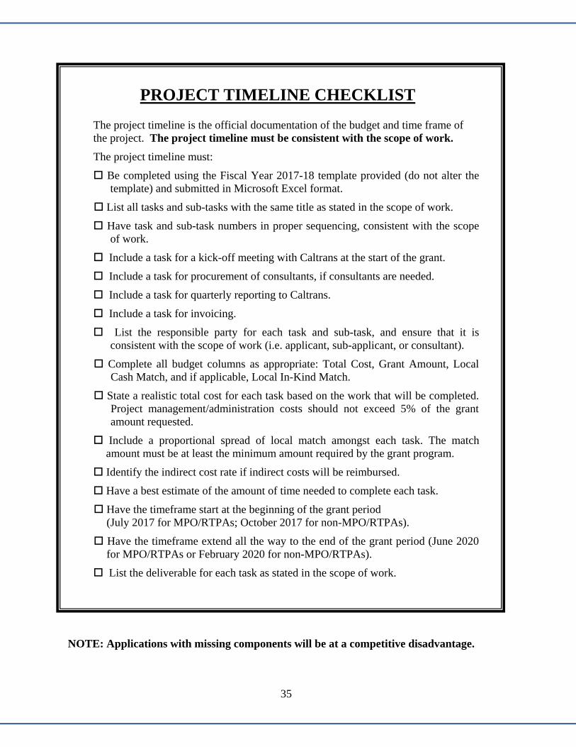
35
PROJECT TIMELINE CHECKLIST
The project timeline is the official documentation of the budget and time frame of the project. The project timeline must be consistent with the scope of work. The project timeline must: Be completed using the Fiscal Year 2017-18 template provided (do not alter the
template) and submitted in Microsoft Excel format. List all tasks and sub-tasks with the same title as stated in the scope of work. Have task and sub-task numbers in proper sequencing, consistent with the scope
of work. Include a task for a kick-off meeting with Caltrans at the start of the grant. Include a task for procurement of consultants, if consultants are needed. Include a task for quarterly reporting to Caltrans. Include a task for invoicing. List the responsible party for each task and sub-task, and ensure that it is
consistent with the scope of work (i.e. applicant, sub-applicant, or consultant). Complete all budget columns as appropriate: Total Cost, Grant Amount, Local
Cash Match, and if applicable, Local In-Kind Match. State a realistic total cost for each task based on the work that will be completed.
Project management/administration costs should not exceed 5% of the grant amount requested.
Include a proportional spread of local match amongst each task. The match amount must be at least the minimum amount required by the grant program.
Identify the indirect cost rate if indirect costs will be reimbursed. Have a best estimate of the amount of time needed to complete each task. Have the timeframe start at the beginning of the grant period (July 2017 for MPO/RTPAs; October 2017 for non-MPO/RTPAs). Have the timeframe extend all the way to the end of the grant period (June 2020
for MPO/RTPAs or February 2020 for non-MPO/RTPAs). List the deliverable for each task as stated in the scope of work.
NOTE: Applications with missing components will be at a competitive disadvantage.

36

37
THIRD PARTY IN-KIND VALUATION PLAN CHECKLIST
The third party in-kind valuation plan is an itemized breakdown by task and sub-task and serves as documentation for the goods and/or services to be donated. The third party in-kind valuation plan must be consistent with the information provided on the Project Timeline and Grant Application Cover Sheet.
This document is required upon grant award as a condition of grant acceptance.
The third party in-kind valuation plan must:
Be completed using the Fiscal Year 2017-18 template provided (do not alter the format).
Name the third party in-kind local match provider.
Describe how the third party in-kind local match will be tracked and documented for accounting purposes.
Describe the fair market value of third party in-kind contributions and how the values were determined.
Include an itemized breakdown by task and sub-task consistent with the project timeline.
Be consistent with the in-kind local match amount reflected on the grant application cover sheet.

38

39
LOCAL RESOLUTION (Not Applicable to MPO/RTPAs)
A local resolution is NOT required at the grant application stage; however, it is required upon award, as a condition of grant acceptance.
The local resolution must:
1. State the title of the project.
2. State the job title of the person authorized to enter into a contract with Caltrans on behalf of the applicant.
3. Be no more than a year old or will not be accepted.
4. Be signed by the governing board of the grant applicant.

40
SAMPLE LOCAL RESOLUTION
CITY OF CAN DO RESOLUTION NO. 009-2012
RESOLUTION OF THE BOARD OF DIRECTORS OF THE CITY OF CAN DO AUTHORIZING THE EXECUTIVE DIRECTOR TO EXECUTE AGREEMENTS
WITH THE CALIFORNIA DEPARTMENT OF TRANSPORTATION
FOR THE CITY OF CAN DO COMPLETE STREET PLAN
WHEREAS, the Board of Directors of the City of Can Do is eligible to receive Federal and/or State funding for certain transportation planning related plans, through the California Department of Transportation; and
WHEREAS, a Restricted Grant Agreement is needed to be executed with the
California Department of Transportation before such funds can be claimed through the Transportation Planning Grant Programs; and
WHEREAS, the City of Can Do wishes to delegate authorization to execute
these agreements and any amendments thereto;
NOW, THEREFORE, BE IT RESOLVED by the Board of Directors of the City of Can Do, authorize the Executive Director, or designee, to execute all Restricted Grant Agreements and any amendments thereto with the California Department of Transportation.
APPROVED AND PASSED this 4th day of August, 2015.
John Doe, Chair
ATTEST:
Eileen Wright, Executive Director
2
3
4
1
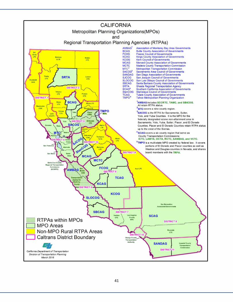
41

42
Caltrans Sustainable Transportation Planning Grant District Contact List
DISTRICT CONTACT MPO/RTPA
DISTRICT 1 1656 Union Street P.O. Box 3700 Eureka, CA 95502
Mendocino and Lake Counties— Rex Jackman (707) 445‐6412 Email: [email protected] Del Norte and Humboldt Counties— Kevin Tucker (707) 441‐5770 Email: [email protected]
Del Norte LTC Humboldt CAOG Lake CCAPC Mendocino COG
DISTRICT 2 1657 Riverside Drive Redding, CA 96001
Kathy Grah (530) 229‐0517 Email: [email protected]
Lassen CTC Tehama CTC Modoc LTC Trinity CTC Plumas CTC Siskiyou CLTC Shasta RTA
DISTRICT 3 703 B Street Marysville, CA 95901
Beatriz Gonzalez (530) 741‐5173 Email: [email protected]
Butte CAG Sierra LTC Colusa CTC Glenn CTC El Dorado CTC Nevada CTC Placer CTPA Sacramento Area COG Tahoe MPO
DISTRICT 4 111 Grand Avenue P.O. Box 23660 Oakland, CA 94623‐0660
Sustainable Communities— Becky Frank (510) 286‐5536 Email: [email protected] Blesilda Gebreyesus (510) 286‐5575 Email: [email protected] Strategic Partnerships— Cameron Oakes (510) 622‐5758 Email: [email protected]
Metropolitan Transportation Commission
DISTRICT 5 50 Higuera Street San Luis Obispo, CA 93401‐5415
Hana Mengsteab (805) 549‐3130 Email: [email protected]
Monterey TAMC Santa Cruz CCRTC San Benito COG Association of Monterey County
Bay Area Governments Santa Barbara CAG San Luis Obispo COG

43
Caltrans Sustainable Transportation Planning Grant District Contact List
DISTRICT CONTACT MPO/RTPA
DISTRICT 6 1352 W. Olive Avenue P.O. Box 12616 Fresno, CA 93778‐2616
Paul Marquez (559) 445‐5867 Email: [email protected]
Fresno COG Tulare CAG Kern COG Kings CAG Madera CTC
DISTRICT 7 100 S. Main Street Los Angeles, CA 90012
Charles Lau (213) 897‐0197 Email: [email protected]
Southern California Association of Governments
DISTRICT 8 464 W. 4th Street Mail Station 722 San Bernardino, CA 92401
Rebecca Forbes (909) 388‐7139 Email: [email protected]
Southern California Association of Governments
DISTRICT 9 500 S. Main Street Bishop, CA 93514
Ryan Dermody (760) 872‐0691 Email: [email protected]
Inyo LTC Mono LTC Eastern Kern (COG)
DISTRICT 10 1976 E. Dr. Martin Luther King Boulevard P.O. Box 2048 Stockton, CA 95201
Mountain Counties— Carl Baker (209) 948‐7325 Email: [email protected] Merced, San Joaquin, Stanislaus Counties— Tom Dumas (209) 941‐1921 Email: [email protected]
Alpine CTC Amador CTC Calaveras COG Mariposa LTC Merced CAG Tuolumne CCAPC San Joaquin COG Stanislaus COG
DISTRICT 11 4050 Taylor Street Mail Station 240 San Diego, CA 92110
Barby Valentine (619) 688‐6003 Email: [email protected]
San Diego Association of Governments
Southern California Association of Governments
DISTRICT 12 3347 Michelson Drive Suite 100 Irvine, CA 92612‐0661
Yatman Kwan (949) 724‐2731 Email: [email protected] Marlon Regisford (949) 724‐2241 Email: [email protected]
Southern California Association of Governments


Status of Lake County Projects: As of September 1, 2016
# County RoutePM
BackPM
AheadProgram Project Location Type of Work
Project Cost (millions)
Status of Project PSR Target Date
LAKE 20 5.20 5.551 $5.70 June 2017
# County RoutePM
BackPM
AheadProgram Project Location Type of Work
Project Cost (millions)
Status of Project
LAKE 20 5.84 5.842 Bridge replacement $2.00
RTL: 2021
# County RoutePM
BackPM
AheadProgram Project Location Type of Work
Project Cost (millions)
Status of ProjectEstimated Completion Date
Start of Work Date
LAKE 20 1.0 46.3 Nov 2019Start: Aug 2018 (prev 05‐18)
RTL: Feb 2018LAKE 20 13.5 30.5 Fall 2018
Start Work: Spring 2017 RTL: May 2016
LAKE 20 31 325
RTL: Feb 2018LAKE var var var
6RTL: 2019
LAKE 29 9.0 20.77 MBGR, widening and $5.30
truck climbing lane RTL: 2019LAKE 29 9.6 10.3
8RTL: Nov 2017
LAKE 29 12.78 14.35shoulder widening $8.10
RTL: 2019LAKE 29 23.8 31.6
10RTL: 2019
LAKE 29 34.17 34.5 Fall 201811 Start Work: Spring 2018
RTL: Aug 2017 LAKE 29 41.42 41.42 March 2018
Start Work: May 2017RTL: Feb 2017
LAKE var var var13
RTL: 2019LAKE 175 25 27.5 2020
14 Start Work: July 2018RTL: March 2018
# County RoutePM
BackPM
AheadProgram Project Location Type of Work
Project Cost (millions)
Status of Project Estimated Completion
LAKE 20 13.5 31.495% complete October 2016
LAKE 29 0.2 0.216 Starting Sept 2016 December 2016
State Route 29 Projects project cost = construction & RWState Route 53 Projects start work 0500
est comp date 0600 y: Reg Plng/Status/Lake/Lake Status Sept 1, 2016.xlsx
Capital Preventative Maint. $25.215
2014 SHOPP 378 Mandates
2012 SHOPP 010 Safety
700 STIP & RIP & SHOPP
$2.500
$180.000
Project Number 0B000J. Matteoli
Project Number OB690J. Matteoli
015 Safety $3.812 Project Number OE850J. Matteoli
112 Bridge Rail replacement
J. MatteoliProject Number OE730K
Project Number OC750J. Matteoli
intersection improvement
J. Matteoli
near Middletown, from east of Putah Cr Bridge to Dry Cr Bridge
$12.221
PSR (Project Study Report) Projects
PSR Complete & Not Yet Programmed (for Design)
2016 SHOPP 010 Safety
Project Number 0B120J. Matteoli
2012 SHOPP 361 Mandates
from Lucerne area east to Route 20/53 upgrade 55 curb ramps & sidewalks
upgrade ped facilities to ADA compliance
Project Number OC810
Near Lower Lake ‐ Lake 29 Expressway upgrade to 4‐lane expresswaywkg on Env doc for 8 mile
proj, const delay 1 yr due to CTC 5‐19‐16 action
estimated advertise 09‐16
on schedule
2014 SHOPP 010 Safety
J. Matteoli
Revised since last report.
Projects Programmed (in Design)
State Route 175 Projects
State Route 20 Projects
Under Construction
4
Amended into 2016 SHOPP
$6.156
9
intersection improvement
12 $0.485
Project Number 42780
$6.017
various on Rte 20, 29, 175 MBGR, widening & rumblestrips
2014 SHOPP 010 Safety
J. Matteoli Project Number 2981U
3
J. Matteoli110 Bridge Rehab on Route 20 three miles west of Upper Lake
2014 SHOPP 151 Roadway
various locations Rte 20, 29 & 53
bridges on 20, 29 & 175
Hartmann Rd/Rte 29
various locations on Route 29 between Middletown and Lower Lake
ramps at Lakeport Blvd overcrossing
152012 SHOPP 121
Roadway from Lucerne area east to Route 20/53
intersection of SR 20/53
Project Number 0A040J. Matteoli
Jaime Matteoli (Project Mgr) Project Number OG330k on schedule
Project Number OF490k
east of Upper Lake, 0.3 mi west of Witter Springs Rd to 0.02 mi east of Witter Sp Rd010 Safety Widen shoulders on both sides of SR 20
PSR signed 6‐20‐16; to be amended into 2018 SHOPP
on schedule
on schedule
on schedule
on schedule
on schedule
$1.057 on schedule
Bridge rail replacement & upgrade ‐ 5 bridges
$4.211
$5.884
119 Bridge Prevent Mt
St Helena Cr Bridge Bridge scour‐repair $.300Project Number 38560J. Matteoli
2016 SHOPP 010 Safety
near Lower Lake, .85 mi N of Spruce Grove Rd‐S to .52 mi S of Hofacker Ln
Amended into 2016 SHOPP
Project Number OE720KJ. Matteoli
on schedule
2014 SHOPP 010 Safety
Cruikshank Rd/Rte 29 NB left‐turn pocket
Shoulder Widening
Project Number OE080J. Matteoli
Project Number OE640J. Matteoli
culvert rehabilitation
Page 1 8/31/2016
Lake TAC Meeting: 9/15/16 Agenda Item: #4di

MENDOCINO
LAKE
COLUSA
SONOMA
NAPA
·|}þ101u
·|}þ281 ·|}þ53
·|}þ175
·|}þ20
·|}þ29
ClearLake
2
11
1
8
5
14
10
7
4
15
3
¯
0 5 10 152.5Miles
StatusPlannedProgrammed
Project Locations, Lake County StatusSeptember, 2016 (See Pg 1)
Pg 2

LAKE COUNTY/CITY AREA PLANNING COUNCIL TAC STAFF REPORT
TITLE: Proposition 53: November 8, 2016 Ballot DATE PREPARED: September 8, 2016 MEETING DATE: September 15, 2016
SUBMITTED BY: Phil Dow, Transportation Planning Principal
BACKGROUND:
Proposition 53 will appear on the November 8, 2016 statewide ballot. It is an initiative that would result in a California constitutional amendment, if passed, to require that State revenue bonds totaling more than $2 billion to be put to a statewide vote.
Proposition 53 is funded by a Stockton area landowner, farmer and businessman who has expressed concern about pervasive government debt.
This initiative is opposed by the League of California Cities, the California Association of Councils of Government (of which APC is a member), and a number of other interests. A two-page summary of government agencies, businesses, and unions that have signed on to the No on Prop 53 effort is attached. The Legislative Analyst Office summary of Proposition 53 is also attached.
Since the threshold of the revenue bond funding clearly applies to revenue bonds in excess of $2 billion, it is highly unlikely to directly affect entities in Lake County. The issue at play here could be one of local control. If the initiative passes, voters statewide will vote on revenue bonds everywhere in the state that exceed the $2 billion threshold. Voters everywhere in California would vote on bond funding for projects of which they are likely to have little or no knowledge of the feasibility or benefit.
At this time, the APC has not been asked to take a position on Proposition 53.This is for informational purposes only.
I also have additional information provided to me by the No on Prop 53 committee as well as an article on the initiative’s sponsor published in Capitol Weekly that I can forward to you if requested.
ACTION REQUIRED: None.
ALTERNATIVES: None identified.
RECOMMENDATION: None. This is for your information only.
Lake TAC Meeting: 9/15/16 Agenda Item: #4ei


Information Packet
Lake TAC Meeting: 9/15/16 Agenda Item: #5

Approved as presented June 8, 2016
LAKE COUNTY/CITY AREA PLANNING COUNCIL Lisa Davey-Bates, Executive Director 367 North State Street, Ukiah, CA 95482
www.lakeapc.org Administration: Suite 204 ~ 707-234-3314 Planning: Suite 206 ~ 707-263-7799
LAKE COUNTY/CITY AREA PLANNING COUNCIL (APC) MEETING MINUTES
Wednesday, May 11, 2016
Location: Moose Lodge, 15900 E Highway 20, Clearlake Oaks
Present Jim Comstock, Supervisor, County of Lake
Russell Perdock, City Council, City of Clearlake Gina Fortino Dickson, Council Member, City of Clearlake
Stacy Mattina, City Council Member, City of Lakeport Martin Scheel, Mayor, City of Lakeport
Chuck Leonard, Member at Large Rachelle Damiata, Member at Large
Absent Jeff Smith, Supervisor, County of Lake
Also Present Lisa Davey-Bates, Executive Director, Admin. Staff – Lake APC
Nephele Barrett, Admin. Staff – Lake APC Alexis Pedrotti, Admin. Staff - Lake APC
Phil Dow, Planning Staff – Lake APC Rex Jackman, Caltrans District 1 Policy Advisory Committee
Jamie Mattioli, Caltrans District 1 Doug Herren, City of Clearlake
1. Call to Order/Roll CallChairperson Scheel called the meeting to order at 10:23 am. Alexis Pedrotti called roll.Members present: Comstock, Perdock, Fortino Dickson, Mattina, Scheel, Leonard, Damiataand Jackman (PAC).
2. Adjourn to Policy Advisory CommitteeChairperson Scheel adjourned to the Policy Advisory Committee (PAC) at 10:23 a.m. to includeRex Jackman, Caltrans District 1, allowing him to participate as a voting member of the LakeAPC.
3. PUBLIC EXPRESSIONNone
CONSENT CALENDAR 4. Approval of April 13, 2016 (Draft) Minutes
Director Fortino Dickson made a motion to approve the consent calendar. The motion was seconded by DirectorLeonard and unanimously approved.
Lake TAC Meeting: 9/15/16 Agenda Item: #5a

2
REGULAR CALENDAR 5. Discussion and Recommended Approval of Resolution # 15-16-16 to Determine if Unmet
Transit Needs are Reasonable to Meet (Barrett) Nephele noted she would brief with the agenda item since the “tour of projects” was scheduled to begin at 10:30. She offered to answer any questions that remained following her presentation. The unmet transit needs list, a resolution, and the unmet needs definition was provided in the board packet for reference. This annual process is to identify and formalize any unmet transit needs by using the APC approved definitions. The current process started in December 2015 at the SSTAC meeting, where the SSTAC members identified potential unmet transit needs. A list was developed and then presented to APC in March 2016. At that meeting, the APC Board of Directors made a finding acknowledging the list did contain unmet transit needs. Since then, LTA and APC Staff have evaluated the list and provided a response. Nephele did note one change to the format of the list; it now separates TDA required unmet needs and other transit related concerns. The focus is on the unmet transit service needs; however for informational purposes staff includes the additional concerns as well. After the analysis was complete, it was taken back to the SSTAC for consideration. Staff is now presenting the Board with specific responses to each unmet need. Nephele updated the board on the unmet transit needs list as noted below: Lake County FY 2016/17 Potential Unmet Transit Needs & Recommended Findings
1. Medical trips to Saint Helena Clearlake and Sutter Health Lakeside and potentially Tribal Health. Recommended Finding: This is not an Unmet Need. This is not an Unmet Need. Extensive transit service is provided to each of these facilities. Clinic provided medical transport and the new Pay-Your-Pal Volunteer Driver Program supplements transit services. Any remaining need is too limited for public transit to serve, and would not meet the approved definition of an Unmet Need as it is not a significant number of people.
2. Eastbound service to Spring Valley and further east, allowing people to connect with service to the Sacramento area. Recommended Finding: This is an Unmet Need, but is not reasonable to meet at this time. Additional planning efforts are needed to explore ways to serve this area and coordinate with other services.
3. Non-Emergency Medical Transportation in outlying areas. Recommended Finding: This is an Unmet Need, but is not reasonable to meet at this time. LTA will continue to explore ways to address this need.
4. Non-Emergency Medical Transportation to out of county locations. Recommended Finding: This may be an Unmet Need, but is not reasonable to meet. Further analysis is needed of the extent of the demand in order to determine if this item meets the definition of Unmet Need and to explore the feasibility of such service.
Transit Related Concerns Identified by SSTAC and TAC for FY 16/17 1. A transit stop at the jail. 2. Accessibility improvements are needed around the fixed route transit stops. 3. Explore funding options/grant eligibility for non-profit transportation services,
including the potential for senior centers/non-profits to become sub-recipients of FTA grant funds.
4. A transit stop at Job Zone with a turnaround. 5. Relocation or pull-outs at fixed route stops on Lakeshore Drive in Clearlake, at
Highlands Park and Austin Park. Nephele concluded her summary and mentioned staff believes that at least some of the needs identified on the list qualify as unmet needs, but none are reasonable to meet at this time. It was recommended that Resolution 15-16-16 be approved, finding that there are no unmet transit needs that are reasonable to meet.

3
Director Leonard made a motion to approve Resolution 15-16-16 the Determination of Unmet Needs. The motion was seconded by Director Fortino Dickson and carried unanimously. Full Roll Call: 8 Ayes - Comstock, Fortino Dickson, Perdock, Mattina, Scheel, Leonard, Damiata and Rex Jackman (PAC); 0 Noes; 0 Abstain; 1 Absent - Smith
6. Status of County of Lake/City of Clearlake Sales Tax Polling Effort
Lisa mentioned there has not been much progress since the last Board Meeting. The consultant, FM3, presented the County’s polling results to the Board of Supervisors. There doesn’t seem to be much interest in moving forward. The City of Clearlake held a special meeting to discuss the polling results. There appeared to be support, and the City will consider the option of moving forward with putting the measure on the November ballot at an upcoming Council meeting. Director Perdock thanked staff for all there help and financial support. He confirmed that the City of Clearlake is moving forward and will be working to get information out and raising funds. The City Council has requested staff move forward and present ballot language to the Council. After reviewing the polling results from the consultant, there was a clear message to move forward with a measure dedicated to improving the City’s streets. Director Scheel noted that the City of Lakeport has decided to develop and distribute an RFP to evaluate voters, but include law enforcement as an option.
7. Presentation of 2016/17 APC Budget (Davey-Bates) Lisa presented the Draft 2016/17 APC Budget, and noted this document is presented solely for review at this board meeting. There is no action required, and the final Budget will be brought back next month for approval. Lisa reported that the LTF revenues have been increased slightly, which will beneficial since the Non-Emergency Medical Transportation (NEMT) allocation will be allocated this coming year again. She noted 5% of the LTF had been allocated to the Consolidated Transportation Services Agency (CTSA) since 2012/13 to initial the NEMT Brokerage program. This Fiscal Year an allocation to the CTSA for NEMT purposes did not occur since there was a large amount of reserve funding in the account. Now that the program is moving forward and a Mobility Manager has been hired, funds will once again be again allocated in FY 2016/17. She briefly discussed additional line items of the budget. She advised revenues and expenditures remained fairly unchanged for 2016/17, and welcomed any questions or comments.
8. Discussion of 2016/17 Overall Work Program (Davey-Bates) Due to time constraints, Lisa noted she’d provide a quick update of the draft document, but advised it had been provided for informational purposes and feedback from the Board. The final Overall Work program will be presented and approved next month. Lisa noted the Overall Work Program includes planning projects that will be happening in the next fiscal year. It includes three new projects; the Regional Transportation Plan Update, Countywide Sign Inventory Project and the Speed Zone Studies for the County of Lake. Lisa welcomed any questions or comments, and offered to give a more detailed summary next month when the final document is presented to the Board for adoption.
RATIFY ACTION 9. Adjourn Policy Advisory Committee and Reconvene as Area Planning Council
Chairperson Scheel adjourned the Policy Advisory Committee at 10:43 am and reconvened as the APC.

4
10. Consideration and Adoption of Recommendations of Policy Advisory Committee Director Leonard made a motion to adopt the recommendations of the Policy Advisory Committee. The motion was seconded by Director Fortino Dickson and carried unanimously.
REPORTS 11. Reports & Information
a. Lake APC Staff Summary of Meetings - Administration and Planning Services Chairperson Scheel referenced the Summary of Meetings report completed by Lisa Davey-Bates, showing a list of meetings attended by APC Administration and Planning Staff. There were no comments or questions. b. Lake APC Planning Staff
1. Active Transportation Program (ATP) Plan Update APC Staff has been working on the draft plan. It is scheduled to be discussed at the Technical Advisory Committee Meeting next week. Staff is hoping to bring the document to the APC Board in June.
2. ATP Cycle 3 Update and Schedule The call for projects is scheduled for April 15, 2016 with a submittal date of June 15, 2016. Currently there are two applications being considered for this ATP grant cycle; the City of Lakeport’s project on Hartley Road, and the City of Clearlake’s Burns Valley Civic Street Scape Improvement project. Clearlake may be submitting the same project last year, although there will be additional work done to improve the application. While on the topic of Planning Staff, Phil Dow reported that Jesse Robertson has accepted a job back with Caltrans District 1. APC Planning will be advertising for the job soon.
3. Lake Transit Hub Relocation Plan Update (Robertson, Wall) This item was previously discussed and reported at the LTA Board meeting.
c. Lake APC Administration Staff
1. Next Meeting Date – June 8, 2016 2. Miscellaneous – None
d. Lake APC Directors
None
e. Caltrans 1. Lake Caltrans Project Status Report It was agreed by the board that the new Caltrans status sheet and map format are very helpful and they really value this. Caltrans will be presenting during the tour regarding the 20/53 roundabout project.
2. Miscellaneous – None
f. California Association of Councils of Governments (CalCOG)
No Update.
g. Rural Counties Task Force No Update. h. Miscellaneous - None

LAKE COUNTY/CITY AREA PLANNING COUNCIL
REGIONAL TRANSPORTATION PLANNING WORK PROGRAM
FISCAL YEAR 2016/17 Adoption by Area Planning Council: June 8, 2016
1st Amendment: August 10, 2016
Prepared by: Lisa Davey-Bates, Executive Director 367 N. State St., Suite 204 Ukiah, CA 95482 707.234.3314
Lake TAC Meeting: 9/15/16 Agenda Item: #5b
Table of Contents Regional Transportation Planning Work Program
Final June 8, 2016
1st Amendment – August 10, 2016 1
TABLE OF CONTENTS TOPIC Page Lake County Area Profile ...................................................................................................................................2 Lake APC Overview ...........................................................................................................................................3 Regional Planning Efforts ..................................................................................................................................4 Introduction .........................................................................................................................................................6 Funding Needs ................................................................................................................................................. 10 Summary of Funding Sources ........................................................................................................................ 11 Summary of 2015/16 Overall Work Program Carryover .......................................................................... 12 Funding Sources by Work Element ............................................................................................................... 13 Funding Sources by Claimant ......................................................................................................................... 14 Expenditure Summary ..................................................................................................................................... 16 SUMMARY OF WORK ELEMENTS: Work Element 600: Regional Planning & Intergovernmental Coordination ................................. 17 Work Element 601: Transit Planning .................................................................................................... 19 Work Element 602: Transit Service Reliability & Performance Monitoring .................................. 20 Work Element 603: Lake County Active Transportation Plan (Carryover) ...................................... 21 Work Element 604: Lake County Project Reserve Account ............................................................. 23 Work Element 605: Federal & State Grant Preparation & Monitoring Program .......................... 24 Work Element 606: Speed Zone Studies – County of Lake (NEW) ......................................... 25 Work Element 607: Special Studies ....................................................................................................... 26 Work Element 608: Planning, Programming & Monitoring ............................................................. 28 Work Element 609: Lake Transit Hub Location Plan (Carryover) ..................................................... 30 Work Element 610: Non-Motorized Transportation ......................................................................... 32 Work Element 611: Pavement Management Program ....................................................................... 33 Work Element 612: Countywide Technology Support Services...................................................... 34 Work Element 613: Transportation Information Outreach .............................................................. 35 Work Element 614: Countywide Sign Inventory Project (New) ................................................ 36 Work Element 615: Regional Transportation Plan Update (New) .......................................... 37 Work Element 616: Training .................................................................................................................. 39
2016/17 Work Program Schedule ................................................................................................................. 40 Information Element ....................................................................................................................................... 41 Appendices ........................................................................................................................................................ 42 Appendix A – Project Status of 2015/16 Work Program Appendix B – Overall Work Program and Budget Revenue Summary FY 2016/17 Appendix C – Memorandum of Understanding Appendix D – Fiscal Year 2016/17 Federal Planning Factors

Lake County Area Profile Regional Transportation Planning Work Program
Final June 8, 2016
1st Amendment – August 10, 2016 2
LAKE COUNTY AREA PROFILE Lake County lies within the coastal range of mountains approximately 100 miles north of San Francisco and 35 miles east of the Pacific Ocean. It is surrounded by Mendocino County on the west, Sonoma and Napa Counties to the south, and Yolo, Colusa and Glenn Counties on the east. State Highway 20 connects the area with both U.S. 101 and Interstate 5. The northern third of the county is largely unoccupied, much of it lying within the Mendocino National Forest. According to the 2010 Census Data, the total population in Lake County was 64,665. This included the unincorporated population of 44,662 and the incorporated population of 20,003. Clearlake is the larger of the two incorporated cities, with a population of 15,250. Lakeport has a population of 4,753. The majority of the population of the county resides along the shores of Clear Lake, the most prominent geographical feature of Lake County. Lake County, although rural in nature, has a number of transportation problems. The ground transportation network is impacted by topography, a growing resident population, declining financial resources and high nonresident recreational traffic use. The more important issues are identified in the 2010 Regional Transportation Plan, adopted October 11, 2010. The largest income producing industries are agriculture, located in the lowlands to the west and southwest of Clear Lake, tourism, and geothermal development, located in the mountainous terrain in the southwestern portion of the County. In recent years, employment associated with tribal economic development has also become a significant factor. Finally, another important factor facing the region is the steady increase of commuting traffic. To look at this issue more closely, a four-county Inter-Regional Partnership (IRP) Report was completed in June 2004 concerning jobs-housing imbalances in Mendocino, Lake, Napa, and Sonoma Counties. The report presented the case that, even though a jobs-housing imbalance crisis may not be apparent yet, indications are that if nothing is done this will be a serious issue in the near future. A County-Wide Micro Simulation Model was completed in FY 2012/13 to analyze projected traffic growth and prioritize transportation projects on the State Highways in Lake County. The Middletown Community Action Plan and Engineered Feasibility Study were also completed in FY 2013/14 to enhance interregional and regional travel while balancing the community of Middletown’s needs.

Lake APC Overview Regional Transportation Planning Work Program
Final June 8, 2016
1st Amendment – August 10, 2016 3
LAKE APC OVERVIEW The Lake County/City Area Planning Council (APC) was established in June 1972 by a Joint Powers Agreement. Subsequently, it was designated by the Secretary of Transportation as the Regional Transportation Planning Agency for Lake County. The cooperative relationship between Caltrans and Area Planning Council was formalized by a Memorandum of Understanding. The member entities amended the Joint Powers Agreement in 1986 to change the membership of the Area Planning Council. It is now composed of eight (8) members, including two (2) members of the Lake County Board of Supervisors, two (2) city council members from the City of Lakeport, two (2) city council members from the City of Clearlake, and two (2) citizen members selected at large by the Board of Supervisors. Two committees serve to advise the Area Planning Council. The Policy Advisory Committee (PAC) is composed of the members of the Area Planning Council itself, together with the District One Director of Transportation, or his representative, from the Caltrans Office in Eureka. The Technical Advisory Committee (TAC) is composed of the Director of Public Works of Lake County, the Community Development Directors of Lake County and the cities of Clearlake and Lakeport, the City Engineers of Clearlake and Lakeport, the Commander of the Lake County Office of the California Highway Patrol, and a transportation planner from the Caltrans District One Office. The Lake County/City Area Planning Council has an active Social Services Transportation Advisory Council (SSTAC). The SSTAC was established to meet the intent of Senate Bill 498 (1987). The SSTAC assists the Area Planning Council in the identification of transit needs that may be reasonable to meet by establishing or contracting for new public transportation services, or specialized transportation services, or by expanding existing services. Recently the SSTAC has been meeting more frequently and in conjunction with the Lake County Transportation Coalition to facilitate coordination of public transit and other transportation needs.
Regional Planning Efforts Regional Transportation Planning Work Program
Final June 8, 2016
1st Amendment – August 10, 2016 4
REGIONAL PLANNING EFFORTS
In October, 1995, the Area Planning Council adopted the Transit Improvement Plan. This Plan was the culmination of a comprehensive transit study performed by a consultant with extensive input from County and City representatives, local elected officials, transit providers, and a wide range of interests in Lake County. One of the major recommendations of the Plan was to form a Transit Authority to provide transit service in Lake County through a Joint Powers Agreement. Establishment of a Transit Authority was approved by the County and the two incorporated cities in December, 1995. In addition, a part-time Transit Manager was hired on a contract basis to oversee transit development and implementation of the Transit Plan.
Lake County 2030, a comprehensive planning tool, was completed under Work Element 618 of the Work Program. This project was partially funded with State Planning and Research and Rural Blueprint grant funds that were provided through Caltrans. Phase I of the project began in Fiscal Year 2007/08, and consisted of preliminary outreach to the local agencies and many other potential stakeholders of the project. This phase also included gathering and developing data to run the model for this project. The second phase of this project was completed in Fiscal Year 2008/09 and included an extensive outreach process by APC staff and MIG consultants to gain knowledge and input by the citizens, local elected officials, local agencies and other stakeholders of their “vision” for Lake County. In February 2009, the Lake APC staff received word from the Department of Transportation (Caltrans) that the grant application to complete Phase III of the Blueprint Program in the amount of $140,000 had been approved. During Fiscal Year 2009/10, the vision and principles, and draft alternative scenarios were developed that were derived from the Public Involvement (Phase II) of the Blueprint project. Further public outreach was conducted in the spring 2010 to determine the ultimate preferred “growth scenario” for the County. During Phase III of the Blueprint Program, staff coordinated with local agency planning staff in the development of the data used in the UPlan model. The Blueprint Advisory Committee (BPAC) developed four alternative growth scenarios that could be compared to each other in another series of community workshops, for the eventual consensus on a Preferred Growth Scenario. The five Phase III workshops were held in February and March of 2010, with two follow-up workshops on a draft Preferred Growth Scenario in June 2010. The Final Blueprint Plan was adopted in October 2010 and summarizes all three phases of the Lake 2030 Regional Blueprint process. In 2011 Caltrans awarded the Lake APC funding to complete the fourth and fifth phases of the Regional Blueprint process. Phase IV developed tools and resources to help local agency staff and project designers, property owners and developers to incorporate Blueprint Principles into planning documents and development project plans. Phase V also conducted additional implementation activities from the tools that were developed in Phase IV. In July 2011, the Lake APC received notification from Caltrans that we had been awarded Partnership Planning funds to complete a Community Action Plan (CAP) in Middletown. The purpose of the CAP is to conduct a comprehensive community outreach effort in Middletown to assist with the development of transportation alternatives along the corridor. Caltrans District 1 also received State Planning & Research funding in 2011 to complete an Engineered Feasibility Study (EFS) within the south portion of the SR 29 corridor to analyze potential transportation improvement alternatives to enhance interregional and regional travel while balancing community needs. The project was completed in FY 2013/14. Lake Area Planning Council was awarded 5304 Rural Transit Planning funds in August 2012 to conduct a Transit Development Plan Update and Marketing Plan. The consultant and Lake APC worked in partnership with Lake Transit Authority to complete the Plan June 2015. Several of the project’s tasks

Regional Planning Efforts Regional Transportation Planning Work Program
Final June 8, 2016
1st Amendment – August 10, 2016 5
include public outreach, including completion of surveys and interviews of existing and potential riders of the transit system. The Plan will develop a five-year operating and capital plan including cost projections. The Marketing Plan will provide marketing strategies and tools to promote the transit system. The Lake County/City Area Planning Council in partnership with Lake Transit Authority received Sustainable Communities Transportation Planning Grant funds to complete a Transit Hub Location Plan under this current Overall Work Program. This project will involve extensive, interactive community engagement with a broad range of stakeholders to identify locations and options for a new transit hub in the City of Clearlake. In 2015/16, the Lake APC initiated the development of the Lake County Active Transportation Program (ATP) Plan to strengthen the opportunity for future grant funds for Active Transportation projects throughout the region. The Plan will identify and prioritize non-motorized and transit improvements projects in Lake County. The Lake APC received Rural Planning Assistance (RPA) grant funding in the amount of $40,000 to enhance the level of public participation and provide assistance to the local agencies. The Lake County/City Area Planning Council will incorporate the planning factors identified in the recently passed Federal transportation bill, Fixing America’s Surface Transportation (FAST) Act, while preparing and implementing planning projects throughout the region.
Introduction Regional Transportation Planning Work Program
Final June 8, 2016
1st Amendment – August 10, 2016 6
INTRODUCTION The Area Planning Council's Transportation Planning Work Program is prepared annually to identify and focus the next year's transportation planning tasks. These tasks are envisioned and are to be fulfilled in accordance with the goals and policies of the Lake County Regional Transportation Plan (RTP) and other planning documents prepared by the Lake APC. The primary goal is to develop a safe, balanced, practical and efficient regional transportation system. This entails timely maintenance as well as capital improvements to the transportation network, which includes the streets and highways. Since the Fiscal Year 1986/87, the Lake County/City Area Planning Council (APC) has contracted with a consultant to do most of the technical planning efforts in the Work Programs. Dow & Associates entered into a contract with the Lake APC (effective October 1, 2006) to continue to perform planning duties. In December 2008 and again in April 2012, the APC Board acted to renew its contract with Dow & Associates for an additional three years. In June 2014, the Lake APC advertised for an Administration/Fiscal Contractor, as well as the Planning duties to be conducted under the Overall Work Program. Dow and Associates was awarded the Planning contract for a five-year period (effective October 1, 2014). Grant funded work elements will likely be completed by consultants hired under this contract and administered through Dow & Associates. PUBLIC PARTICIPATION The Area Planning Council encourages public participation in the planning and decision making process and holds public hearings whenever an important decision concerning transportation is imminent. In addition to these public hearings which are announced in local newspapers, parties known to be interested in specific issues are invited to both the Technical Advisory Committee and the Area Planning Council meetings, when appropriate. As required by SAFETEA-LU, the Lake APC developed a Public Participation Plan in Fiscal Year 2008/09 to enhance its public outreach efforts. The development of this Plan includes strategies to engage and notify the public when conducting planning activities. The plan provides a clear directive for public participation activities of the APC, particularly when they pertain to the development and implementation of the Regional Transportation Plan (RTP), Regional Transportation Improvement Program (RTIP), Overall Work Program (OWP), administration of the Transit Development Act (TDA), Federal and state grant programs, Coordinated Human Transportation Plan, transit studies, area transportation plans, blueprint planning and other special projects. The Lake APC began the update of the Lake County Regional Transportation Plan in Fiscal Year 2008/09, which was adopted in October 2010. An extensive public outreach effort occurred during the development of this long-range transportation planning document. An update to the current document is scheduled to begin this FY 2015/16, with an expected plan adoption of October 2017. As discussed in the previous section, the Lake APC conducted an extensive public outreach for multiple years as part of the development of the regional Blueprint plan, Lake County 2030. The Lake APC also received two grants in July 2011, one of which included Community-Based Transportation Planning grant funding to complete a Downtown Corridor Plan in the City of Clearlake. The other included Partnership Planning grant funds to complete a Middletown Community Action Plan, which was conducted simultaneously with the SR 29 Engineered Feasibility Study. These planning projects included tasks to conduct extensive public outreach activities through a charrette process.

Introduction Regional Transportation Planning Work Program
Final June 8, 2016
1st Amendment – August 10, 2016 7
The Lake APC provided funding in the Overall Work Program to update the Human Services Coordinated Plan, completed June 2015. The update conducted outreach, data collection and analysis to determine gaps in service and strategies to improve mobility to low-income, older adults and those with disabilities. A Title VI Program was also conducted in 2013/14 which is required by Federal regulation to those who receive FTA funding. The Plan is required to be updated every three years and submitted to Caltrans. The Program requires a complaint procedure process, minority representation on advisory bodies (at times), interpretation opportunities and outreach to the limited English proficient (LEP) populations. Transit providers, such as Lake Transit Authority, who provide fixed-route service, must provide additional information. COMPLETED PRODUCTS IN PRIOR WORK PROGRAM Appendix A includes a brief synopsis of products that were completed in the 2015/16 Work Program.
Introduction Regional Transportation Planning Work Program
Final June 8, 2016
1st Amendment – August 10, 2016 8
2016/17 WORK ELEMENTS The Lake County/City Area Planning Council is dedicated to working cooperatively with all agencies to provide comprehensive planning in the region. There are two new work elements included in the 2016/17 work program. The remaining elements are either ongoing work elements that appear repetitively in Work Programs or carryover projects that will be completed in this Overall Work Program. Several projects are also discussed below that are support planning efforts on a regional level. The following work elements are included in the 2016/17 Work Program, and are briefly described below:
Work Element 600 – This work element includes funding for general planning activities to be completed by the regional transportation planning agency (Lake APC), the transit agency (Lake Transit Authority), County and two cities.
Work Element 601 –This work element will help determine the need for public
transportation in Lake County and strive to provide a reliable source of mobility for all citizens.
Work Element 602 – An element initiated in Fiscal Year 2007/08 to provide transit
service performance monitoring on an ongoing basis for Lake Transit Authority. Work Element 603 – This carryover project will create an Active Transportation Plan
(ATP) for the Lake County region. The ATP will identify and prioritize non-motorized and transit station/stop improvement projects and conduct public outreach to strengthen future grant applications for Active Transportation projects within the region.
Work Element 604 – This element has been designated as a reserve account for planning
projects to be completed by. Lake County, City of Lakeport and City of Clearlake that are often not funded due to a lack of funding from year-to-year in the Overall Work Program.
Work Element 605 –This work element continues to provide funding to assist agencies
in the preparation of applications and monitoring of Federal and State grants to improve the transportation system in Lake County.
Work Element 606 – This work element was established as an ongoing to gather and
interpret roadway, traffic, and accident data for Lake County in order to establish and enforce appropriate traffic speed limits in the community.
Work Element 607 – Special Studies has been included in the past several work
programs and will be used to perform studies, collect data, update the transportation data base, respond to local issues, and aid in implementation of the Regional Transportation Plan, and other projects as needed.
Work Element 608 – Planning, Programming & Monitoring is an ongoing work element
to provide assistance associated with project development for Regional Improvement Program projects and other planning activities

Introduction Regional Transportation Planning Work Program
Final June 8, 2016
1st Amendment – August 10, 2016 9
Work Element 609 – This carryover project will be to finalize the development the
Transit Hub Location Plan for the Lake Transit Authority. It will involve extensive, interactive community engagement with a broad range of stakeholders to identify locations and options for a new transit hub in the City of Clearlake
Work Element 610 – To encourage growth to bicycle and pedestrian travel to the region
by integrating and promoting bicycle and pedestrian facilities and services with roadway and transit planning operations.
Work Element 611 –Pavement Management Program Update, an ongoing project to provide a systematic method for determining roadway pavement maintenance, rehabilitation, and reconstruction needs. Triennial updates are conducted to provide an updated streets/roads inventory.
Work Element 612 – Technology Support Services has been an ongoing project to
provide GIS support services to agencies within Lake County involved with the roadway transportation system, aviation, bike/pedestrian, and transit planning. The name has been changed to incorporate additional technology needs in the county.
Work Element 613 – Transportation Information Outreach is a work element that informs and educates residents of Lake County on transportation related activities. This work element also maintains the agency’s website
Work Element 614 – The Countywide Sign Inventory Project is a NEW work element to provide the County of Lake and cities of Lakeport and Clearlake with a current inventory of all traffic signs on the maintained street/road systems.
Work Element 615 – The Regional Transportation Plan is a long-range planning
document that provides a clear vision of the regional transportation goals, policies, objectives and strategies for an effective transportation system for Lake County. The plan guides decisions about all types of transportation and the related facilities needed for an effective transportation system. Statute requires RTP updates every five years.
Work Element 616 – This work element will provide training to staff of upcoming requirements for grant programs, changes in technologies relating to transportation planning, and other useful educational opportunities as needed.

Funding Needs Regional Transportation Planning Work Program
Final June 8, 2016
1st Amendment – August 10, 2016 10
FUNDING NEEDS The amended 2016/17 Transportation Planning Work Program requires total funding of $505,226 and will be funded from a combination of Sustainable Transportation Planning Grant Funds, Rural Planning Assistance (RPA) funds, and Local Transportation Funds (LTF), Planning, Programming & Monitoring (PPM) funds. FEDERAL The Lake APC does not currently have any federal funds identified in the Fiscal Year’s work program. STATE Estimated Rural Planning Assistance (RPA) funds in the amount of $294,000 are expected for FY 2016/17. These funds are only available after the passage of the State Budget and on a reimbursement basis. It is permissible to carry over up to 25% of RPA funding from the prior year’s Work Program. Carryover RPA Funds from the 2015/16 Work Program total $18,991. Total RPA Funds programmed in the 2016/17 Work Program are $312,991. Work Program products funded by RPA funds must be received by Caltrans District 1 staff prior to requesting full reimbursement of funds. Also included in this Overall Work Program is carryover State Highway Account Sustainable Communities (SHA-SC) grant funds in the amount of $29,945. These funds were awarded to the Lake APC in FY 2015/16, will be used to complete the Lake Transit Hub Location Plan. LOCAL The total new Local Transportation Funds (LTF) commitment will be $50,000 in the 2016/17 Work Program. LTF Funds carried over from the 2015/16 Work Program in the amount of $22,177 are being carried over to be used under several work elements in the 2016/17 Work Program. Total LTF Funds committed to the 2016/17 Work Program total $72,177. Planning, Programming & Monitoring Funds in the amount of $68,000 were allocated for FY 2016/17. In addition, prior PPM funding in the amount of $22,113 was set aside in Work Element 604 in order to complete a larger regionally significant project. Total PPM Funds committed to the 2016/17 Work Program total $90,113. The total commitment from local funding sources totals $162,290 (32%) plus carryover funding which will be included in the Final 2016/17 OWP.
Summary of Funding Sources Regional Transportation Planning Work Program
Final June 8, 2016
1st Amendment – August 10, 2016 11
LAKE COUNTY WORK PROGRAM SUMMARY OF FUNDING SOURCES
Fiscal Year 2016/17
FUNDING SOURCE AMOUNT FUNDING %
Federal Funding SourcesNoneTotal Federal Funds: $0 0%
State Funding SourcesRural Planning Assistance - 2016/17 $294,000 58%Rural Planning Assistance - (2015/16 Carryover) $18,991 0%State Transit Account - Sustainable Communities (SHA-SC) (15/16) $29,945 0%Total State Funds: $342,936 58%
Federal and State Funding: $342,936 68%
Local Funding SourcesLocal Transportation Funds - 2016/17 $50,000 10%Local Transportation Funds - (Carryover-See Page 14 for Breakdown by Fiscal Year) $22,177 0%Total Local Transportation Funds: $72,177 14%
Planning, Programming & Monitoring (PPM) - 2016/17 $68,000 13%Planning, Programming & Monitoring - (Carryover-See Page 14 for Breakdown by Fiscal Year) $22,113 0%Total Planning, Programming & Monitoring Funds: $90,113 13%
Local Funding: $162,290 32%
TOTAL PROGRAM FUNDING REVENUES $505,226 100%

Summary of Funding Sources Regional Transportation Planning Work Program
Final June 8, 2016
1st Amendment – August 10, 2016 12
SUMMARY OF 2015/16 CARRYOVER BY FUNDING SOURCE
LOCALLTF 600 $67 10/11 Actual carry over amount to be used for direct expenses.
$892 14/15 Actual carry over amount to be used for direct expenses.
602 $4,918 14/15WE came in under budget, funds will be added to WE 604 Reserve for fuure projects.
603 $294 13/14 Actual carry over amount to be used for direct expenses.
$108 14/15 Actual carry over amount to be used for direct expenses.
605 $500 13/14 Actual carry over amount to be used for direct expenses.
606 $233 14/15 Actual carry over amount to be used for direct expenses.
607 $526 14/15 Actual carry over amount to be used for direct expenses.
609 $3,889 15/16 Actual carry over amount to complete proejct.
$385 14/15 Actual carry over amount to be used for direct expenses.
612 $500 14/15 Actual carry over amount to be used for direct expenses.
613 $305 13/14 Actual carry over amount to be used for direct expenses.
$500 15/16 Actual carry over amount to be used for direct expenses.
614 $2,636 15/16WE came in under budget, funds will be added to WE 604 Reserve for fuure projects.
620 $2,128 14/15 Actual carry over amount to be used for direct expenses.$3,716 15/16 Actual carry over amount to be used for direct expenses.
621 $580 12/13WE came in under budget, funds will be added to WE 604 Reserve for fuure projects.
TOTAL LTF CARRYOVER: $22,177
PPM604 $2,113 14/15 Actual Carryover amount for WE 604 Reserve Account.
$20,000 15/16 Actual Carryover amount for WE 604 Reserve Account.TOTAL PPM CARRYOVER: $22,113
STATERural Planning Assistance (RPA) 601 $2,593 15/16 These funds have been carried over to complete this Project.
602 $3,500 15/16 These funds have been carried over to complete this Project.603 $1,67015/16 GranThese funds have been carried over to complete this Project.
$1,000 15/16 These funds have been carried over to complete this Project.613 $228 15/16 These funds have been carried over to complete this Project.620 $10,000 15/16 These funds have been carried over for a PMP Training.
State Hwy Acct Sustainable Comm.(SHA-SC 609 $29,945 15/16 These funds have been carried over to complete this Project.TOTAL STATE CARRYOVER: $48,936
FEDERALTOTAL FEDERAL CARRYOVER: $0TOTAL CARRYOVER: $93,226
10/11 = $6712/13 = $58013/14= $1,09914/15 = $9,69015/16 = $10,741 Total LTF = $22,177
14/15 = $2,11315/16 = $20,000

Summary of Funding Sources by Work Element Regional Transportation Planning Work Program
Final June 8, 2016
1st Amendment – August 10, 2016 13
LAKE COUNTY WORK PROGRAM SUMMARY OF FUNDING SOURCES
BY WORK ELEMENT WE Work Element Project Description RPA LTF PPM Other Total
600 Regional Planning & Intergovernmental Coordination 129,229$ 2,959$ -$ -$ 132,188$ 601 Transit Planning 7,500$ 2,500$ -$ -$ 10,000$ 602 Transit Service Reliability & Performance Monitoring 28,500$ -$ 2,000$ -$ 30,500$ 603 L.C Active Transportation Program Plan (Carryover ) 5,262$ 402$ -$ -$ 5,664$ 604 Lake County Project Reserve Funds -$ 8,134$ -$ -$ 8,134$ 605 Federal & State Grant Preparation 25,500$ 6,951$ 10,000$ -$ 42,451$ 606 Speed Zone Studies- County of Lake (NEW) 12,500$ 233$ -$ -$ 12,733$ 607 Special Studies 20,000$ 22,026$ -$ -$ 42,026$ 608 Planning, Programming, & Monitoring 22,500$ -$ -$ -$ 22,500$ 609 Lake Transit Hub Location Plan (Carryover) -$ 4,274$ -$ 29,945$ 34,219$ 610 Non-Motorized Transportation 10,000$ -$ -$ -$ 10,000$ 611 Pavement Management Program Inventory -$ -$ 6,000$ -$ 6,000$ 612 Technology Support Services -$ 3,000$ -$ -$ 3,000$ 613 Transportation Information Outreach -$ 2,967$ -$ -$ 2,967$ 614 Countywide Sign Inventory Project (NEW) -$ 12,387$ 72,113$ -$ 84,500$ 615 Regional Transportation Plan (NEW) 42,000$ 500$ -$ -$ 42,500$ 616 Training 10,000$ 5,844$ -$ -$ 15,844$
312,991$ 72,177$ 90,113$ 29,945$ 505,226$ Total Funding Sources

Summary of Funding Sources by Claimant Regional Transportation Planning Work Program
Final June 8, 2016
1st Amendment – August 10, 2016
14
LAKE COUNTY WORK PROGRAM SUMMARY OF FUNDING SOURCES BY CLAIMANT
Lake APC Staff TransitDPW Consultant Manager
600 Regional Planning & Intergovernmental Coordination -$ -$ -$ -$ -$ 2,959$ 2,959$ 601 Transit Planning -$ -$ -$ -$ 2,500$ -$ 2,500$ 603 L.C Active Transportation Program Plan (Carryover) -$ -$ -$ -$ -$ 402$ 402$ 604 Lake County Project Reserve Funds -$ -$ -$ -$ -$ 8,134$ 8,134$ 605 Federal & State Grant Preparation 5,000$ -$ -$ 1,451$ -$ 500$ 6,951$ 606 Speed Zone Studies (NEW) -$ -$ -$ -$ -$ 233$ 233$ 607 Special Studies 5,000$ 4,000$ 5,000$ 7,500$ -$ 526$ 22,026$ 609 Lake Transit Hub Location Plan (Carryover) -$ -$ -$ 233$ 157$ 3,884$ 4,274$ 612 Technology Support Services -$ -$ 2,500$ -$ -$ 500$ 3,000$ 613 Transportation Information Outreach -$ -$ -$ 2,000$ -$ 967$ 2,967$ 614 Countywide Sign Inventory Project (NEW) -$ -$ -$ -$ -$ 12,387$ 12,387$ 615 Regional Transportation Plan Update (NEW) -$ -$ -$ -$ -$ 500$ 500$ 620 Training -$ -$ -$ 5,844$ -$ -$ 5,844$
10,000$ 4,000$ 7,500$ 17,028$ 2,657$ 30,992$ 72,177$
Local Transportation Fund (LTF)
Total LTF Funding by Claimant
TotalWE Lakeport Clearlake OtherWE Project Description
Lake APC Staff TransitDPW Consultant Manager
602 Transit Service Reliability & Performance Monitoring -$ -$ -$ -$ 2,000$ -$ 2,000$ 604 Lake County Project Reserve Funds -$ -$ -$ -$ -$ -$ -$ 605 Federal & State Grant Preparation & Monitoring 10,000$ -$ -$ -$ -$ -$ 10,000$ 611 Pavement Management Program -$ -$ -$ -$ -$ 6,000$ 6,000$ 614 Countywide Sign Inventory Project (NEW) 7,000$ 1,000$ 1,500$ -$ -$ 62,613$ 72,113$
Total PPM Funds by Claimant 17,000$ 1,000$ 1,500$ -$ 2,000$ 68,613$ 90,113$
Planning, Programming & Monitoring (PPM)TotalWE WE Project Description Lakeport Clearlake Other

Summary of Funding Sources by Claimant Regional Transportation Planning Work Program
Final June 8, 2016
1st Amendment – August 10, 2016
15
Lake APC Staff TransitDPW Consultant Manager
600 Regional Plng & Intergovernmental Coordination 5,000$ -$ 1,500$ 122,729$ -$ -$ 129,229$ 601 Transit Planning -$ -$ -$ 5,000$ 2,500$ -$ 7,500$ 602 Transit Service Reliability & Performance Monitoring -$ -$ -$ -$ -$ 28,500$ 28,500$ 603 L.C Active Transportation Program Plan (Carryover) -$ -$ -$ 5,262$ -$ -$ 5,262$ 605 Federal & State Grant Preparation & Monitoring -$ -$ 2,000$ 23,500$ -$ -$ 25,500$ 606 Speed Zone Studies - County of Lake (New) -$ -$ -$ 12,500$ -$ -$ 12,500$ 607 Special Studies 5,000$ -$ -$ 15,000$ -$ -$ 20,000$ 608 Planning, Programming & Monitoring 10,000$ -$ 2,500$ 10,000$ -$ -$ 22,500$ 610 Non-Motorized Transportation -$ -$ -$ 10,000$ -$ -$ 10,000$ 615 Regional Transportation Plan Update (NEW) -$ -$ -$ 42,000$ -$ -$ 42,000$ 616 Training -$ -$ -$ -$ -$ 10,000$ 10,000$
20,000$ -$ 6,000$ 245,991$ 2,500$ 38,500$ 312,991$
Rural Planning Assistance (RPA)
Total RPA Funding by Claimant
TotalWE Lakeport Clearlake OtherWE Project Description
CDD/ Lake Public APC Staff TransitAdmin. DPW Health Consultant Manager
Federal:609 Lake Transit Hub Location Plan (Carryover) -$ -$ -$ -$ -$ 1,730$ 1,213$ 27,002$ $29,945
Total Funds by Claimant $0 $0 $0 $0 $0 $1,730 $1,213 $27,002 $29,945
Other Funding:TotalWE WE Project Description Lakeport Clearlake Other
Total Funds Available: $505,226

Summary of Expenditures by Work Element Regional Transportation Planning Work Program
Final June 8, 2016
1st Amendment – August 10, 2016 16
LAKE COUNTY WORK PROGRAM SUMMARY OF EXPENDITURES
BY WORK ELEMENT
WE Title Lake DPW Lakeport Clearlake APC Staff
ConsultantTransit
Manager Other Total Costs
600 Regional Planning & Intergovernmental Coordination $ 5,000 $ - $ 1,500 $ 122,729 $ - $ 2,959 132,188$ 601 Transit Planning $ - $ - $ - $ 5,000 $ 5,000 $ - 10,000$ 602 Transit Service Reliability & Performance Monitoring $ - $ - $ - $ - $ 2,000 $ 28,500 30,500$ 603 L.C. Active Transportation Plan (Carryover) $ - $ - $ - $ 5,262 $ - $ 402 5,664$ 604 Lake County Project Reserve Funds $ - $ - $ - $ - $ - $ 8,134 8,134$ 605 Federal & State Grant Preparation $ 15,000 $ - $ 2,000 $ 24,951 $ - $ 500 42,451$ 606 Speed Zone Studies - County of Lake (New) $ - $ - $ - $ 12,500 $ - $ 233 12,733$ 607 Special Studies $ 10,000 $ 4,000 $ 5,000 $ 22,500 $ - $ 526 42,026$ 608 Planning, Programming, & Monitoring $ 10,000 $ - $ 2,500 $ 10,000 $ - $ - 22,500$ 609 Lake Transit Location Plan (Carryover) $ - $ - $ - $ 1,963 $ 1,370 $ 30,886 34,219$ 610 Non-Motorized Transportation $ - $ - $ - $ 10,000 $ - $ - 10,000$ 611 Pavement Management Program $ - $ - $ - $ - $ - $ 6,000 6,000$ 612 Technology Support Services $ - $ - $ 2,500 $ - $ - $ 500 3,000$ 613 Transportation Information Outreach $ - $ - $ - $ 2,000 $ - $ 967 2,967$ 614 Countywide Sign Inventory Project (New) $ 7,000 $ 1,000 $ 1,500 $ - $ - $ 75,000 84,500$ 615 Regional Transportation Plan Update (New) $ - $ - $ - $ 42,000 $ - $ 500 42,500$ 616 Training $ - $ - $ - $ 5,844 $ - $ 10,000 15,844$
$ 47,000 $ 5,000 $ 15,000 $ 264,749 $ 8,370 $ 165,107 $ 505,226 Totals

Work Program Schedule Regional Transportation Planning Work Program
Final June 8, 2016
1st Amendment – August 10, 2016
17
WORK ELEMENT 600 – REGIONAL PLANNING & INTERGOVERNMENTAL COORDINATION PURPOSE: Provide ongoing coordination with outside agencies and jurisdictions on current and long-range planning, programming and funding, and make policy and technical recommendations to the Area Planning Council.
PREVIOUS WORK: This work element provides ongoing planning duties. Work completed varies each year according to planning needs, yet consistently includes completion of work programs, amendments, and quarterly reports, involvement in and completion/updates of planning projects such as the Regional Transportation Plan, Regional Bikeway Plan, Blueprint Plan, Human Services Coordinated Plan, Transit Plans and other special studies, participation in local, regional, statewide and committee meetings, and responding to legislative requirements and changes. TASKS: 1. Coordinate with APC Administration Staff, local agencies (including tribal governments) and
Caltrans to assist in preparing the draft and final work programs and amendments. (APC Staff: Ongoing/Products: Draft & Final Work Programs)
2. Manage work program throughout the year, which includes coordinating with local agency staff, preparing quarterly reports to Caltrans on status of work program and developing an annual report defining work program expenses by element. (APC Staff: Ongoing/Products: Quarterly Status Reports)
3. Prepare, attend and follow-up to Lake County/City Area Planning Council (APC), Social Services Transportation Advisory Council (SSTAC), Technical Advisory Committee (TAC) meetings, and conduct public hearings as necessary. (APC Staff: Ongoing/Products: Meeting agendas, minutes, resolutions, technical reports, staff reports, public outreach materials, etc.)
4. Provide ongoing planning duties which include participation in California Transportation Commission (CTC), and other meetings as necessary; travel and work assignments; and evaluation of regional planning issues as directed by APC and TAC. (APC Staff: As needed/Products: Meeting materials, staff reports, CTC meeting materials such as allocation requests, etc.)
5. Review/comment on transportation planning documents provided by Caltrans and local agencies. (APC Staff: Ongoing/Products: Examples of work products are included under previous work above.)
6. Prepare and update regional planning documents and coordinated plans as needed (APC Staff: Ongoing/Products: Examples of work products are included under previous work above.)
7. Cooperate with Caltrans in development of system planning products. (APC Staff: As needed/Products: Examples may include Transportation Concept Reports, Interregional Transportation Strategic Plan, California State Freight Mobility Plan, etc.)
8. Respond, as necessary, to legislative requirements and changes in transportation planning process. (APC Staff: Ongoing/Products: Letters, resolutions, etc.)
9. Coordinate and consult with Native American Tribal governments during the planning process, and document Tribal government-to-government relations. (APC Staff: Ongoing/Products: Correspondence, public outreach materials, meeting materials)
10. Implementation of the Federal transportation bill and respond to associated planning-related duties such as project status reports and other required reporting and monitoring and communication with local agencies of projects, and Federal planning factors. (APC Staff: As needed/Products: Correspondence, reports, resolutions, etc.)
11. Conduct and document outreach efforts to all segments of the community, including tribal governments and Native American Communities in accordance with the Introduction – Public

Work Program Schedule Regional Transportation Planning Work Program
Final June 8, 2016
1st Amendment – August 10, 2016
18
Participation section of this OWP. (APC Staff: Ongoing/Products: Public outreach materials, meeting materials)
12. Review and comment on environmental documents that are regional and/or interregional in nature. (APC Staff: As needed/Products: Neg Decs, Environmental Impact Reports, etc.) –only Local Funding will be used to complete this task.
13. Provide $2,000 local funding contribution to Rural Counties Task Force for the purpose of assisting in costs related to meetings. (RCTF: Annually/Product: Meeting materials, workshop and forum materials, other materials relating to transportation issues of regional/state significance.
PRODUCTS: Meeting agendas and minutes, resolutions, technical reports to the Area Planning Council and Technical Advisory Committee, quarterly work program status reports, draft and final work programs, and amendments as necessary, final report defining work program expenses, updates to APC on statewide and other meetings attended as necessary, written reports on issues of concern to APC and TAC and other status reports as necessary. FUNDING SOURCES AND AGENCY PARTICIPATION:
Responsible AgencyApprox.
Person DaysBudget Fiscal Year
Funding Source
City of Clearlake 2 $1,500 16/17 RPACounty of Lake-DPW 7 $5,000 16/17 RPAAPC Staff Consultant 158 $122,500 16/17 RPA
0 $228.85 15/16 RPARCTF Dues N/A $2,000 16/17 LTFDirect Exepenses $892 14/15 LTF
$67 10/11 LTF$129,000 - 16/17 RPA$228.85 - 15/16 RPA$2,000 - 16/17 LTF$892 - 14/15 LTF$67 - 10/11 LTF
TOTAL: 166 $132,188

Work Program Schedule Regional Transportation Planning Work Program
Final June 8, 2016
1st Amendment – August 10, 2016
19
WORK ELEMENT 601 – TRANSIT PLANNING PURPOSE: Determine the need for public transportation in Lake County and strive to provide a reliable source of mobility for all citizens. PREVIOUS WORK: Review of social service agency coordination; Section 5310, 5311, 5316, 5317 and other federal funding review, ranking and project support, workshops; preparation of monthly transit summary and evaluation reports; participation on Social Services Transportation Advisory Council (SSTAC); consultation and coordination with tribal governments on transit-related planning and project programming activities.
TASKS: 1. Evaluate social services coordination as required and meet with Social Services Transportation
Advisory Council and other community-based groups to obtain input on coordination issues, review and comment on SSTAC recommendations. (Transit Manager: As needed)
2. Participate in Section 5310 and 5311 grant funding and other transit grant funding opportunities, as appropriate. (Transit Manager: As needed) –only Local Funding will be used to complete this task.
3. Review Federal legislation and FTA guidance to determine how to utilize programs and consider necessary involvement, including completion and updates of the coordinated human service transportation plan. (APC Staff, Transit Manager: As needed)
4. Review and comment on technical correspondence, report on other transit issues as assigned by the APC or TAC. (APC Staff, Transit Manager: Ongoing)
5. Prepare grants/request for proposals as needed to support transit planning efforts (Transit Manager, APC staff, Consultant: As required and/or as needed.)
6. Maintain ongoing consultation process with tribal governments regarding tribal transit needs to enable their participation in transportation planning and programming activities. (Transit Manager: Ongoing)
7. Coordinate with local agencies (including tribal governments) and Caltrans to prepare draft and final work programs and amendments. (APC Staff: As needed)
8. Coordinate the Unmet Transit Needs Process, and ensure coordination with the Regional Transportation Plan. (APC Staff / LTA: As needed)
9. Prepare, attend and follow-up to Lake Transit Authority (LTA), and Social Services Transportation Advisory Council (SSTAC) meetings, and conduct public hearings as necessary. (APC Staff, Transit Manager: Ongoing)
PRODUCTS: LTA meeting agendas and minutes, resolutions, technical reports to the Area Planning
Council and Technical Advisory Committee, quarterly work program status reports, draft and final work programs, and amendments as necessary, monthly transit summary and evaluation reports, staff reports, reporting pertaining to SAFETEA-LU & MAP-21, written reports on issues of concern to APC and TAC and other status reports as necessary.
FUNDING SOURCES AND AGENCY PARTICIPATION:
Responsible AgencyApprox.
Person DaysBudget Fiscal Year
Funding Source
APC Staff 18 $5,000 16/17 RPATransit Manager 4 $2,500 16/17 RPA
4 $2,500 16/17 LTFTOTAL: 22 $10,000
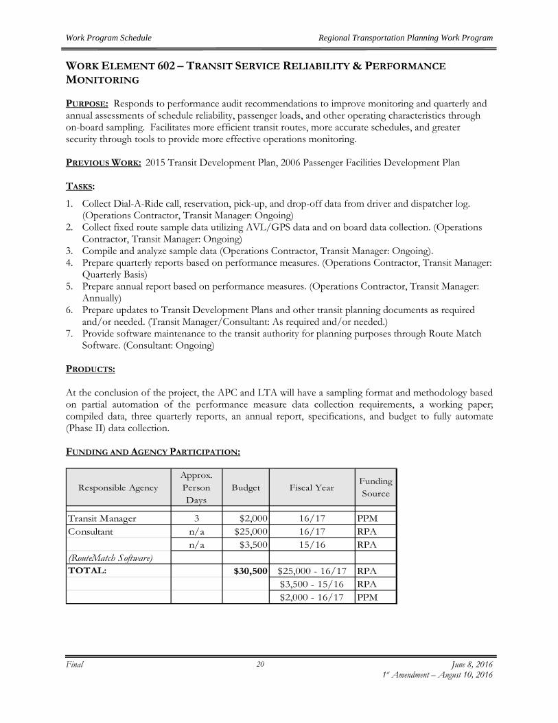
Work Program Schedule Regional Transportation Planning Work Program
Final June 8, 2016
1st Amendment – August 10, 2016
20
WORK ELEMENT 602 – TRANSIT SERVICE RELIABILITY & PERFORMANCE MONITORING PURPOSE: Responds to performance audit recommendations to improve monitoring and quarterly and annual assessments of schedule reliability, passenger loads, and other operating characteristics through on-board sampling. Facilitates more efficient transit routes, more accurate schedules, and greater security through tools to provide more effective operations monitoring. PREVIOUS WORK: 2015 Transit Development Plan, 2006 Passenger Facilities Development Plan TASKS:
1. Collect Dial-A-Ride call, reservation, pick-up, and drop-off data from driver and dispatcher log. (Operations Contractor, Transit Manager: Ongoing)
2. Collect fixed route sample data utilizing AVL/GPS data and on board data collection. (Operations Contractor, Transit Manager: Ongoing)
3. Compile and analyze sample data (Operations Contractor, Transit Manager: Ongoing). 4. Prepare quarterly reports based on performance measures. (Operations Contractor, Transit Manager:
Quarterly Basis) 5. Prepare annual report based on performance measures. (Operations Contractor, Transit Manager:
Annually) 6. Prepare updates to Transit Development Plans and other transit planning documents as required
and/or needed. (Transit Manager/Consultant: As required and/or needed.) 7. Provide software maintenance to the transit authority for planning purposes through Route Match
Software. (Consultant: Ongoing) PRODUCTS: At the conclusion of the project, the APC and LTA will have a sampling format and methodology based on partial automation of the performance measure data collection requirements, a working paper; compiled data, three quarterly reports, an annual report, specifications, and budget to fully automate (Phase II) data collection. FUNDING AND AGENCY PARTICIPATION:
Responsible AgencyApprox. Person Days
Budget Fiscal YearFunding Source
Transit Manager 3 $2,000 16/17 PPMConsultant n/a $25,000 16/17 RPA
n/a $3,500 15/16 RPA(RouteMatch Software)TOTAL: $30,500 $25,000 - 16/17 RPA
$3,500 - 15/16 RPA$2,000 - 16/17 PPM

Work Program Schedule Regional Transportation Planning Work Program
Final June 8, 2016
1st Amendment – August 10, 2016
21
WORK ELEMENT 603 – LAKE COUNTY ACTIVE TRANSPORTATION PLAN (CARRYOVER) PURPOSE: This project will create an Active Transportation Plan (ATP) for the Lake County region. The ATP will identify and prioritize non-motorized and transit station/stop improvement projects and conduct public outreach to strengthen future grant applications for Active Transportation projects within the region. PREVIOUS WORK: The ATP will be consistent with the 2010 Lake County Regional Transportation Plan, the 2011 Lake County Regional Transportation Bikeway Plan, the 2009 Lake County Safe Routes to School Plan, the Lake County 2030 Regional Blueprint, the Middletown Community Action Plan, the Konocti Regional Trails (KRT) Master Plan, the Human Services Coordinated Plan and the 2015 Transit Development and Marketing Plan, time permitting. TASKS:
Completed in FY 2015/16:
1. Research and review local, regional, state and federal guidelines, plans and policies for the Active Transportation Program. (APC staff)
2. Establish an Active Transportation Advisory Committee (ATAC) and convene meetings of the ATAC to discuss and identify challenges, priorities and strategies, and obtain input over the course of developing the Active Transportation Plan. (APC staff)
3. Provide Project Mapping and GIS Database, research data and assess existing condition, and identify route segments and options. (APC Staff, County, Cities: Ongoing)
4. Provide regular updates to the APC Directors, Lake APC TAC and SSTAC, including background information, draft documents for review, and opportunities to discuss and provide input on the development of the ATP. (APC staff)
5. Coordinate with appropriate federal, state, and local agencies to solicit their input and obtain relevant information. (APC staff)
6. Conduct consultation with Tribal Communities. (APC staff) 7. Conduct public participation and outreach consistent with the 2008 Public Participation Plan. Outreach efforts may
include communication with key stakeholder groups, distribution of information to the public through local media, community events and the Lake APC website, and presentations to community organizations. Conduct a public review of the Active Transportation Plan. (APC staff)
8. Attend meetings, public workshops, and training sessions relevant to the development of the ATP. (APC staff)
9. Prepare an Administrative Draft and Draft ATP. (APC staff) 10. Review Draft ATP. (ATAC, Lake TAC, SSTAC, APC, Caltrans) 11. Prepare Final ATP. (APC staff) 12. Present Final ATP for approval and adoption by APC. (APC staff)
PRODUCTS: Documentation and notes from discussions with APC, ATAC, Lake TAC, SSTAC, LTA, and other entities; public participation and outreach materials, Administrative Draft, Draft, and Final ATP. (CEQA documents, if necessary.)

Work Program Schedule Regional Transportation Planning Work Program
Final June 8, 2016
1st Amendment – August 10, 2016
22
FUNDING AND AGENCY PARTICIPATION:
Responsible AgencyApprox.
Person DaysBudget Fiscal Year Funding Source
APC Staff 2 $1,670 15/16 RPA Grant5 $3,592 15/16 RPA
Direct Expenses $108 14/15 LTF$294 13/14 LTF
TOTAL: $5,664 RPA

Work Program Schedule Regional Transportation Planning Work Program
Final June 8, 2016
1st Amendment – August 10, 2016
23
WORK ELEMENT 604 –LAKE COUNTY PROJECT RESERVE FUNDS Purpose: To reserve funding to perform projects that are not typically funded in Lake County because of the lack of funding available in any “one” given fiscal year. The reserve account will allow the opportunity to accumulate funding to complete projects that have been needed for many years. Initial projects being considered for completion may be a Countywide Traffic Sign Inventory, an update to the Pavement Management Program, or additional funding to complete the first Active Transportation Program (ATP) Plan PREVIOUS WORK: None to date. TASKS:
No tasks will be initiated in FY 2016/17. Funding is reserved for a future project, which is anticipated to be programmed in FY 2016/17. PRODUCTS: No products will be produced in FY 2016/17. FUNDING AND AGENCY PARTICIPATION:
Responsible AgencyApprox. Person Days
Budget Fiscal YearFunding Source
Reserve N/A $2,636 15/16 LTFN/A $4,918 14/15 LTFN/A $580 12/13 LTF
TOTAL: N/A $8,134

Work Program Schedule Regional Transportation Planning Work Program
Final June 8, 2016
1st Amendment – August 10, 2016
24
WORK ELEMENT 605 – FEDERAL & STATE GRANT PREPARATION & MONITORING PURPOSE: Maximize federal and State sources that may be available to improve all modes of transportation in Lake County. PREVIOUS WORK: DPW gathered and analyzed accident data, then prepared applications for HES funding. Bicycle Transportation Account (BTA) application and Safe Routes to School applications have also been submitted. TASKS:
1. Establish entity priorities for the current fiscal year. (County & cities: Ongoing) 2. Review available federal and State transportation grants that may be available to meet local priorities.
Caltrans planning grant opportunities can be accessed at www.dot.ca.gov/hq/tpp/grants.htm (County, Cities, APC Staff: Ongoing) –only Local Funding will be used to complete this task.
3. Prioritize grants by purpose, funding source, matching requirements, granting authority, and availability. (County, Cities, APC Staff: Ongoing)
4. Utilize entity staff or consultants to gather required information and prepare grant documents. (County & cities, APC Staff: Ongoing)
5. Submit grant applications to appropriate agencies including but not limited to the Active Transportation Program (ATP), grant applications pertaining to the Federal Transportation Bill and other programs. (County, Cities, APC Staff: Ongoing) –only Local Funding will be used to complete this task.
6. As necessary, coordinate and consult with all tribal governments on grant process and development of grants. (Local Agencies, APC Staff: Ongoing)
PRODUCTS: Copies of grant applications will be prepared on behalf of APC, cities of Lakeport, and Clearlake, and Lake County.
FUNDING SOURCES AND AGENCY PARTICIPATION:
Responsible AgencyApprox.
Person Days Budget Fiscal YearFunding Source
County of Lake-DPW 7 $5,000 16/17 LTF15 $10,000 16/17 PPM
City of Clearlake 3 $2,000 16/17 RPAAPC Staff Consultant 30 $23,500 16/17 RPA
2 $1,451 16/17 LTFDirect Expenses N/A $500 13/14 LTFTOTAL: 58 $42,451 $25,500 - 16/17 RPA
$10,000 - 16/17 PPM$500 - 13/14 LTF
$6,451 - 16/17 LTF

Work Program Schedule Regional Transportation Planning Work Program
Final June 8, 2016
1st Amendment – August 10, 2016
25
WORK ELEMENT 606 – SPEED ZONE STUDIES –COUNTY OF LAKE (NEW) PURPOSE: To gather and interpret roadway, traffic, and accident data in order to establish and enforce appropriate traffic speed limits in the community, to improve safety for automobiles, bicycles and pedestrian use.
PREVIOUS WORK: Speed Zone Studies for County of Lake were previously completed as part of the 2011/12 Overall Work Program.
TASKS: 1. Meet with Local Agency staff to determine scope of study effort. (Local Agency Staff, APC Staff:
July-December) 2. Develop a data collection plan to ensure appropriate speed sampling. (Staff Consultant) 3. Collect spot speed data at selected locations. (APC Staff: July-December) 4. Research accident history of streets selected for speed sampling. (APC Staff: July-December) 5. Coordinate study with data from WE 607 Special Studies; and WE 608 Planning, Programming and
Monitoring, to reduce duplication of work and analysis, as appropriate. (APC Staff: Ongoing) 6. Collect field data regarding traffic and roadway characteristics. (APC Staff: March-June) 7. Analyze data and prepare report of findings, including recommendations for implementation. (APC
Staff: May-June) 8. Present document to Local Agencies for consideration. (APC Staff: May-June)
PRODUCT: Final Speed Zone Study Report FUNDING AND AGENCY PARTICIPATION:
Responsible AgencyApprox.
Person Days Budget Fiscal YearFunding Source
APC Staff Consultant 16 $12,500 16/17 RPADirect Expenses N/A $233 14/15 LTFTOTAL: 16 $12,733

Work Program Schedule Regional Transportation Planning Work Program
Final June 8, 2016
1st Amendment – August 10, 2016
26
WORK ELEMENT 607 – SPECIAL STUDIES PURPOSE: Collect data and perform studies for the County and two cities which will be useful to update the transportation data base, respond to local issues, aid in implementation of the Regional Transportation Plan, Active Transportation Program and other projects as needed. PREVIOUS WORK: Previous work performed under this element has included: traffic studies in the County of Lake and City of Clearlake; roundabout review in City of Lakeport; crosswalk reviews in the City of Clearlake and Middletown; purchased traffic counters and performed traffic counts countywide to prepare Traffic Monitoring Program, purchased equipment for City of Lakeport, GIS equipment and technical support for Cities of Lakeport & Clearlake, and Roadway Safety Analysis. This is an ongoing project which was initiated several years ago and will continue in this fiscal year. TASKS:
1. Perform studies, volume monitoring, inventories, analyses, and evaluations to ensure adequate data is available for County roads and City streets in Clearlake and Lakeport. (APC Staff, Lake County DPW, cities & Consultant: Ongoing)
2. Provide timely transportation related data and technical support to aid in the evaluation of local issues, including the development of and updates to transportation planning documents. (APC Staff, Lake County DPW, cities & Consultant: Ongoing)
3. Prepare grants/RFPs and coordinate studies consistent with data from Speed Zone Studies, Federal & State Grant Preparation and Monitoring, and Planning, Programming & Monitoring to reduce duplication of work and analysis. (APC Staff: Ongoing)
4. Preparation and monitoring of the Regional Transportation Plan and other regional planning documents. (APC Staff, Lake County DPW, cities & Consultant: Ongoing)
5. Coordination and consultation with Native American Tribal Governments as appropriate, and document Tribal government-to-government relations. (APC Staff, County DPW and Cities: Ongoing)
6. Perform county-wide speed/volume surveys and traffic counts to support a variety of planning documents/studies that may not be completed through WE 603. (Lake County DPW & cities, APC Staff, Consultant: Annually)
7. Evaluate high accident roadway segments; the options for repair, and preparation of cost estimates for desired alternatives. (APC Staff, Lake County DPW, cities & Consultant: Ongoing)
8. Perform updates to sign inventory programs, and pavement marking & sign inventories, and conduct traffic safety inspections. (Consultant, APC Staff, Lake County DPW and Cities: Ongoing) –only Local Funding will be used to complete this task.
PRODUCTS:
1. Special Studies Summary which outlines scope, recipient agency, cost, and completion date of projects. (APC Staff, Consultants, Lake County DPW & Cities)
2. Report of final results of speed and volume studies on County Maintained Roads and City Streets. (APC Staff)
3. Report that identifies the top ten accident producing roadway segments. (Lake County DPW, cities)
4. Proposed corrective measures and cost estimates. (Consultants, Lake County DPW and Cities) 5. Updates to transportation planning projects such as sign inventory programs, traffic counting
programs, bikeway and pedestrian projects, and other data bases. (Consultants, Lake County DPW and Cities)

Work Program Schedule Regional Transportation Planning Work Program
Final June 8, 2016
1st Amendment – August 10, 2016
27
FUNDING SOURCES AND AGENCY PARTICIPATION:
Responsible AgencyApprox.
Person DaysBudget Fiscal Year Funding Source
7 $5,000 16/17 LTF7 $5,000 16/17 RPA
City of Lakeport 6 $4,000 16/17 LTFCity of Clearlake 8 $5,000 16/17 LTF
APC Staff Consultant 19 $15,000 16/17 RPA10 $7,500 16/17 LTF
Direct Expenses n/a $526 14/15 LTFTOTAL: 57 $42,026 $20,000 – 16/17 RPA
$21,500 - 16/17 LTF$526 - 14/15 LTF
County of Lake-DPW

Work Program Schedule Regional Transportation Planning Work Program
Final June 8, 2016
1st Amendment – August 10, 2016
28
WORK ELEMENT 608 - PLANNING, PROGRAMMING & MONITORING PURPOSE: This element will provide planning, programming, and monitoring activities associated with project development for RTIP (Regional Transportation Improvement Program) projects; coordination of ITIP (Interregional Transportation Improvement Projects) and the STIP (State Transportation Improvement Program); maintain Countywide Traffic Monitoring Program and respond to, major changes in transportation planning process. PREVIOUS WORK: Implementation of SB 45 legislative requirements; development of SB 45 funding distribution formula; and participation in SB 45 Guidelines development; development of RTIPs and Amendments; coordination with Caltrans and local agencies on various Planning, Programming & Monitoring (PPM) activities.
TASKS: 1. Attendance at STIP related meetings at the statewide, regional and local level; coordination with local
Cities and County. (APC Staff: Ongoing) 2. Ongoing coordination of STIP Guidelines. (APC Staff: Ongoing) 3. Ongoing review/response to STIP related correspondence as needed. (APC Staff: Ongoing) 4. Development of policy issues for the APC’s consideration. (APC Staff: Ongoing) 5. Development of state and local project funding priorities for the APC’s consideration. (APC Staff:
Ongoing) 6. Review new and existing funding plans, program sources and develop/update a priority list for each
improvement type and funding source. (Lake County DPW and Cities: Ongoing) 7. Prepare and update a five-year improvement plan. (Lake County DPW: Ongoing) 8. Maintain/develop cost estimates for existing and proposed improvement projects (Consultant,
County and Cities: As needed) 9. Planning, programming, and monitoring activities associated with RTIPs, ITIPs, STIPs and
Amendments; coordination with Caltrans and CTC, and provide assistance to local agencies. (APC Staff, Lake County DPW and Cities: Ongoing)
10. Monitor progress of Federal Transportation Bill activities and candidate projects; provide assistance and coordination with local agencies regarding projects. (APC Staff: Ongoing - PPM Funds Only)
11. Prepare preliminary engineering reports to include projects’ scope of work, costs and timelines. (Lake County DPW, Cities & Consultant: As needed – PPM Funds Only)
12. Conduct and update bicycle, pedestrian and vehicular counts and maintain traffic monitoring program (APC Staff Consultant, Consultant, County and Cities: As needed/Ongoing)
13. Coordinate and consult with Tribal governments on planning, programming and monitoring activities, and document Tribal government-to-government relations. (Lake Staff, Lake County DPW and Cities: Ongoing)
14. Purchase software/annual license for Streetsaver for County & both cities. The Streetsaver program is utilized as a planning tool that helps prioritize future Regional Transportation Plan projects. (Software)
15. Purchase and Maintain equipment and software necessary to collect data and provide funding to process acquired data.
PRODUCTS: Products may include staff comments, reports, and recommendations on STIP correspondence and guidelines; possible RTIP Amendments, extension requests, or other STIP documents, and Project Study Reports and maintenance of Traffic Monitoring Program.

Work Program Schedule Regional Transportation Planning Work Program
Final June 8, 2016
1st Amendment – August 10, 2016
29
FUNDING SOURCES AND AGENCY PARTICIPATION:
Responsible AgencyApprox.
Person DaysBudget Fiscal Year
Funding Source
County of Lake-DPW 15 $10,000 16/17 RPACity of Clearlake 4 $2,500 16/17 RPAAPC Staff Consultant 13 $10,000 16/17 RPATOTAL: 107 $22,500 16/17 RPA

Work Program Schedule Regional Transportation Planning Work Program
Final June 8, 2016
1st Amendment – August 10, 2016
30
WORK ELEMENT 609 - LAKE TRANSIT HUB LOCATION PLAN (CARRYOVER) PURPOSE: To develop the Transit Hub Location Plan for the Lake Transit Authority. This project will involve extensive, interactive community engagement with a broad range of stakeholders to identify locations and options for a new transit hub in the City of Clearlake. A consultant team will translate community input into design concepts, assess their feasibility, and prepare a final prioritized plan and cost estimates.
PREVIOUS WORK: 2008 and 2015 Transit Development Plan,
TASKS: 1. Project Planning & Coordination
1.1 Conduct Kickoff Meeting (APC Staff & Transit Manager: July 2015) 1.2 Procure Consultant Team (APC Staff & Transit Manager: August - September 2015) 1.3 On-going Coordination (APC Staff, Transit Manager & Consultant: August 2015 - May 2016) 1.4 Document Conditions and Prepare Base Maps (Consultant: October – December 2015)
2. Community Outreach & Engagement 2.1 Develop and Disseminate Media and Publicity Materials (APC Staff, Transit Manager &
Consultant: January – February 2016) 2.2 Agenda Development and Logistics (APC Staff, Transit Manager & Consultant: January –
February 2016) 2.3 One-day Charrette (APC Staff, Transit Manager & Consultant: March 2016)
3. Draft & Final Plan 3.1 Prepare Administrative Draft Plan (APC Staff, Transit Manager & Consultant: March - April
2016) 3.2 Public Review of Draft Plan (APC Staff, Transit Manager & Consultant: May 2016) 3.3 Final Draft (Consultant: June 2016) 3.4 Board Adoption (Consultant: June 2016)
4. Grant Management 4.1 Quarterly Reporting (APC Staff & Transit Manager: Ongoing) 4.2 Invoicing (APC Staff & Transit Manager: Ongoing)
PRODUCTS: Consultant RFP, Distribution List, Executed Contract, list of Advisory Group Members, Meeting Agendas and Minutes, Existing Conditions Report, Base Maps, Outreach materials, Presentations, review of Public Input, Administrative Draft Plan, Public Review Document, Final Draft Report, Final Plan and Presentation, Quarterly Reports, and Invoicing Packages.

Work Program Schedule Regional Transportation Planning Work Program
Final June 8, 2016
1st Amendment – August 10, 2016
31
FUNDING AND AGENCY PARTICIPATION:
Responsible AgencyApprox.
Person Days Budget Fiscal Year Funding Source
APC Staff Consultant $233.98 15/16 LTF$1,730.17 15/16 Sustainable Grant
Transit Manager $157.16 15/16 LTF$1,213.01 15/16 Sustainable Grant
Consultant $3,498.32 15/16 LTF$27,001.37 15/16 Sustainable Grant
Direct Expenses n/a $385.00 14/15 LTFTOTAL: 0 $34,219.01 $3,889.46 - 15/16 LTF
$29,944.55 - 15/16 Sustainable Grant$385 - 14/15 LTF

Work Program Schedule Regional Transportation Planning Work Program
Final June 8, 2016
1st Amendment – August 10, 2016
32
WORK ELEMENT 610 – NON-MOTORIZED TRANSPORTATION PURPOSE: To encourage growth to bicycle and pedestrian travel in the region by integrating and promoting bicycle and pedestrian facilities and services with roadway and transit planning operations.
PREVIOUS WORK: Regional Bikeway Plan, Non-Motorized Element of Regional Bikeway Plan, successful Safe Routes to School, Bicycle Transportation Account (BTA) and Active Transportation Program (ATP) Grants, Safe Routes to School Plan, Lake County 2030 Blueprint Plan. TASKS: 1. Coordinate bicycle and pedestrian transportation planning, including coordination with local,
regional and state agencies (including tribal governments) regarding various funding sources. (APC Staff: Ongoing)
2. Promote input and assistance to local, regional and state agencies on how to integrate bicycle and pedestrian features into roadway and land use development. (APC Staff: Ongoing)
3. Assist local jurisdictions in the development of regional plans and blueprint program. (APC Staff: Ongoing)
4. Investigate methods to reduce vehicle travel by expanding and enhancing bicycle and pedestrian travel by incorporating features of the California Complete Streets Act into project planning. (APC Staff: Ongoing)
5. Encourage and assist in the submittal of grant applications to support the development of bike and pedestrian planning projects through Work Element 605 of this Work Program. (APC Staff: Ongoing)
6. Coordinate and consult with Native American Tribal governments during the planning process, and document Tribal government-to-government relations. (APC Staff: Ongoing)
7. As necessary, conduct and document outreach efforts to all segments of the community, including tribal governments and Native American Communities in accordance with the Introduction – Public Participation section of this OWP. (APC Staff: Ongoing)
PRODUCTS: Updated bicycle and pedestrian elements of the Regional Transportation Plan, Regional Bikeway Plans, and grant applications and projects. FUNDING SOURCES AND AGENCY PARTICIPATION:
Responsible AgencyApprox.
Person DaysBudget Fiscal Year
Funding Source
APC Staff Consultant 20 $10,000 16/17 RPA TOTAL: 20 $10,000 RPA

Work Program Schedule Regional Transportation Planning Work Program
Final June 8, 2016
1st Amendment – August 10, 2016
33
WORK ELEMENT 611 – PAVEMENT MANAGEMENT PROGRAM PURPOSE: To update the County of Lake’s, City of Clearlake’s and the City of Lakeport’s Pavement Management Program (PMP) to provide a systematic method for determining roadway pavement maintenance, rehabilitation, reconstruction needs to lead to improving safety for automobiles, bikes and pedestrians use. This project includes a component to link the PMP database to the County and the Cities’ Geographic Information System (GIS) street centerlines. PREVIOUS WORK: Development of the Pavement Management System was completed in 1997 and funded through the Lake County/City Area Planning Council Planning Work Program. Updates to the PMP are on a three-year cycle on a countywide basis. The first update was completed in FY 2004/05, again in FY 2007/08 and again in FY 2010/11. TASKS: 1. Purchase software/annual license for Streetsaver Version 9 from MTC for County & both cities.
(Software)
PRODUCTS: PMP Streetsaver Software upgrades/Annual Licenses FUNDING SOURCES AND AGENCY PARTICIPATION:
Responsible AgencyApprox. Person Days
Budget Fiscal YearFunding Source
Software n/a $6,000 16/17 PPM
n/aTOTAL: $6,000
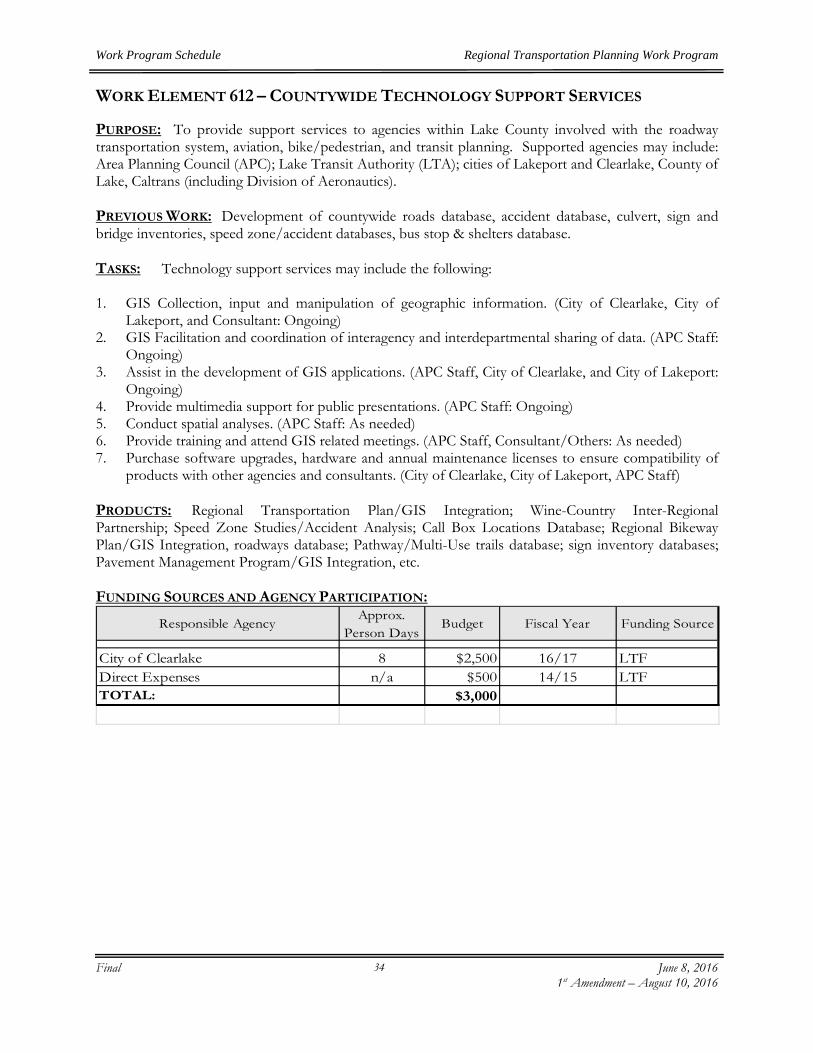
Work Program Schedule Regional Transportation Planning Work Program
Final June 8, 2016
1st Amendment – August 10, 2016
34
WORK ELEMENT 612 – COUNTYWIDE TECHNOLOGY SUPPORT SERVICES PURPOSE: To provide support services to agencies within Lake County involved with the roadway transportation system, aviation, bike/pedestrian, and transit planning. Supported agencies may include: Area Planning Council (APC); Lake Transit Authority (LTA); cities of Lakeport and Clearlake, County of Lake, Caltrans (including Division of Aeronautics). PREVIOUS WORK: Development of countywide roads database, accident database, culvert, sign and bridge inventories, speed zone/accident databases, bus stop & shelters database.
TASKS: Technology support services may include the following: 1. GIS Collection, input and manipulation of geographic information. (City of Clearlake, City of
Lakeport, and Consultant: Ongoing) 2. GIS Facilitation and coordination of interagency and interdepartmental sharing of data. (APC Staff:
Ongoing) 3. Assist in the development of GIS applications. (APC Staff, City of Clearlake, and City of Lakeport:
Ongoing) 4. Provide multimedia support for public presentations. (APC Staff: Ongoing) 5. Conduct spatial analyses. (APC Staff: As needed) 6. Provide training and attend GIS related meetings. (APC Staff, Consultant/Others: As needed) 7. Purchase software upgrades, hardware and annual maintenance licenses to ensure compatibility of
products with other agencies and consultants. (City of Clearlake, City of Lakeport, APC Staff) PRODUCTS: Regional Transportation Plan/GIS Integration; Wine-Country Inter-Regional Partnership; Speed Zone Studies/Accident Analysis; Call Box Locations Database; Regional Bikeway Plan/GIS Integration, roadways database; Pathway/Multi-Use trails database; sign inventory databases; Pavement Management Program/GIS Integration, etc. FUNDING SOURCES AND AGENCY PARTICIPATION:
Responsible AgencyApprox.
Person DaysBudget Fiscal Year Funding Source
City of Clearlake 8 $2,500 16/17 LTFDirect Expenses n/a $500 14/15 LTFTOTAL: $3,000

Work Program Schedule Regional Transportation Planning Work Program
Final June 8, 2016
1st Amendment – August 10, 2016
35
WORK ELEMENT 613 – TRANSPORTATION INFORMATION OUTREACH AND PUBLIC PARTICIPATION PURPOSE: To inform and educate Lake County residents and visitors on transportation issues, and provide opportunities for public input consistent with the 2008 Lake APC Public Participation Plan. Provide access to plans, reports and other information by facilitating public participation opportunities.
PREVIOUS WORK: The Lake APC website was developed in 2005 and is a useful tool that provides access to various reports, plans, on-line surveys, public notices, and upcoming meetings/workshops. TASKS: 1. Coordinate with the County, Cities of Lakeport and Clearlake, Lake Transit Authority, Caltrans and
other agencies/businesses when possible to develop informational materials. (APC Staff: Ongoing) 2. Coordinate and consult, as possible, with all potentially impacted Tribal Governments, and
document Tribal government-to-government relations. (APC Staff: Ongoing) 3. As possible, conduct outreach to low income, disabled and elderly. (APC Staff: Ongoing) 4. Update Lake APC website as necessary to ensure transportation related materials are posted on a
timely basis and available to the public. (APC Staff: As needed) 5. As necessary, conduct and document outreach efforts to all segments of the community in
accordance with the Introduction – Public Participation section of this document and the 2008 Lake APC Public Participation Plan. (APC Staff: Ongoing)
PRODUCTS: 1. Website (LakeAPC.org) with current transportation outreach materials, plans and reports. 2. Outreach materials for specific projects
FUNDING SOURCES AND AGENCY PARTICIPATION:
Responsible AgencyApprox.
Person DaysBudget Fiscal Year Funding Source
APC Staff Consultant 6 $2,000 16/17 LTFDirect Costs n/a $162 16/17 LTF
n/a $500 15/16 LTFn/a $305 13/14 LTF
TOTAL: 6 $2,967

Work Program Schedule Regional Transportation Planning Work Program
Final June 8, 2016 1st Amendment – August 10, 2016
36
WORK ELEMENT 614 – COUNTYWIDE SIGN INVENTORY PLAN (NEW)
PURPOSE: To provide the Lake County, City of Lakeport and City of Clearlake Public Works Departments with a current inventory of all Traffic Signs within the County and Cities’ Maintained Road/Street Systems.
PREVIOUS WORK:
Traffic Sign Inventory conducted in 2003.
TASKS: 1. Prepare RFP and solicit proposals to conduct traffic sign inventory project. (Lake County
DPW and Lake APC Admin.) 2. Award contract to conduct sign inventory project. (Lake County DPW and Lake APC
Admin.) 3. Conduct traffic sign inventory for all signs within the County and Cities Maintained
Road/Street system including GPS coordinates, photos, sign retro-reflectivity, size, type, condition and other attributes as needed. (Consultant, Lake County DPW)
4. Enter data collected for each sign into County and Cities’ existing sign database or otherdatabase as recommended by consultant. (Consultant, Lake County DPW)
5. Provide training on sign inventory program. (Consultant, Lake County DPW, City ofLakeport, City of Clearlake)
PRODUCTS: Current Traffic Sign Inventory for Lake County and cities of Lakeport and Clearlake.
FUNDING SOURCES AND AGENCY PARTICIPATION:
Responsible AgencyApprox.
Person DaysBudget Fiscal Year
Funding Source
County of Lake-DPW 10 $7,000 16/17 PPMCity of Lakeport 1 $1,000 16/17 PPMCity of Clearlake 2 $1,500 16/17 PPMConsultant 81 $62,613 16/17 PPM
16 $12,387 16/17 LTFTOTAL: 107 $84,500 $72,113 - 16/17 PPM
$12,387 - 16/17 LTF

Work Program Schedule Regional Transportation Planning Work Program
Final June 8, 2016
1st Amendment – August 10, 2016
37
WORK ELEMENT 615 – REGIONAL TRANSPORTATION PLAN UPDATE (NEW) PURPOSE: The Regional Transportation Plan provides a clear vision of the regional transportation goals, policies, objectives and strategies for an effective transportation system for Lake County. The plan guides decisions about all types of transportation and the related facilities needed for an effective transportation system. PREVIOUS WORK: The last RTP was adopted by the Lake APC in October 2010. Staff reviewed Caltrans RTP Guidelines, and relevant plans, reports and legislation developed since the last RTP was adopted. Staff reviewed and updated existing goals policies and objectives, initiated public involvement and outreach efforts, established and convened an RTP Community Advisory Committee, requested consultation with each Tribal Chairperson for the seven tribes in Lake County, provided information to the APC, TAC and SSTAC. TASKS:
1. Review and revise existing RTP (2010) Goals, Policies and Objectives. (APC Staff: Ongoing) 2. Research and review local, state and federal plans, reports and guidelines developed since the
2010 RTP was completed. (APC Staff: Ongoing) 3. Ensure Lake County’s Regional Transportation Plan goals are consistent with the goals of
the 2040 California Transportation Plan. 4. Establish an RTP Community Advisory Committee (CAC) and convene meetings of the
CAC to discuss and identify challenges, priorities and strategies, and obtain input over the course of developing the RTP. (APC Staff: Ongoing)
5. Research and analyze information relevant to the elements of the RTP, including policies, existing conditions, funding resources, transportation modeling, demographics, performance measures, and potential improvement projects. Develop relevant maps, cost estimates, charts and graphics. Develop a project list for each element of the RTP. (APC Staff: Ongoing)
6. Provide regular updates to the APC Directors, Lake APC TAC and SSTAC, including background information, draft documents for review, and opportunities to discuss and provide input of the development of the RTP. (APC Staff: Ongoing)
7. Coordinate with appropriate federal, state and local agencies to solicit their input and obtain relevant information. (APC Staff: Ongoing)
8. Conduct consultation with Tribal Communities. (APC Staff: Ongoing) 9. Conduct Public Participation and Outreach efforts consistent with the 2008 Public
Participation Plan. Outreach efforts may include communication with key stakeholder groups, distribution of information to the public through local media, community events and the Lake APC website, and presentations to community organizations. Conduct Public Review of the RTP. (APC Staff: Ongoing)
10. Attend meetings, workshops and training sessions relevant to the development of the RTP. 11. Complete analysis and documents as required under the California Environmental Quality
Act (CEQA) 12. Prepare an Administrative Draft and Draft RTP. (APC Staff) 13. Review Draft RTP. (CAC, TAC, SSTAC, APC, Caltrans). 14. Prepare Final RTP (APC Staff) 15. Present final RTP for approval and adoption by APC. (Staff Consultant)

Work Program Schedule Regional Transportation Planning Work Program
Final June 8, 2016
1st Amendment – August 10, 2016
38
PRODUCTS: Presentations to and notes from discussions with the APC, Lake TAC, RTP CAC, SSTAC and other entities; public participation and outreach materials, Administrative Draft, Draft and Final RTP; CEQA documents. FUNDING SOURCES AND AGENCY PARTICIPATION:
Responsible AgencyApprox.
Person DaysBudget Fiscal Year Funding Source
APC Staff Consultant 30 $42,000 16/17 RPADirect Costs N/A $500 16/17 LTFTOTAL: 30 $42,500

Work Program Schedule Regional Transportation Planning Work Program
Final June 8, 2016
1st Amendment – August 10, 2016
39
WORK ELEMENT 616 – TRAINING PURPOSE: To provide funding for technical training in the transportation planning field to the Lake County/City Area Planning Council (APC) planning staff, to keep informed of changes in the field. PREVIOUS WORK: CalCOG Leadership Forum, ITS Managing Transportation & Land Use Interactions, Fundamentals of Traffic Engineering, Regional Blueprint Planning Workshops & Trainings, California’s Brownfield’s Training, Focus on the Future Conference, CTA/CalACT Conferences TASKS: 1. Attendance at transportation planning academies, conferences, seminars or workshops that may be
offered through Caltrans or other agencies. (APC Staff: As needed) PRODUCTS: Educational materials & resources, Trained staff FUNDING SOURCES AND AGENCY PARTICIPATION:
Responsible AgencyApprox. Person Days
Budget Fiscal YearFunding Source
APC Staff Consultant/APC Members (includes direct costs-registration, travel, hotel, meals, etc.)
n/a $3,716 15/16 LTF
$2,128 12/13 LTFConsultant / Other $10,000 15/16 RPA
$15,844 TOTAL:

Work Program Schedule Regional Transportation Planning Work Program
Final June 8, 2016
1st Amendment – August 10, 2016
40
LAKE COUNTY/CITY AREA PLANNING COUNCIL
2016/17 WORK PROGRAM SCHEDULE Work
Element July August September October November December January February March April May June
600
601
602
603
604
605
606
607
608
609
610
611
612
613
614
615
616

Information Element Regional Transportation Planning Work Program
Final June 8, 2016
1st Amendment – August 10, 2016
41
INFORMATION ELEMENT Per the 2016/17 Overall Work Program Guidelines, the Lake County/City Area Planning Council was requested to include an Information Element to promote coordination in the region through awareness of Caltrans and RTPA planning activities and where they may compliment or intersect one another. Products(s) Project Description

Appendices Regional Transportation Planning Work Program
Final June 8, 2016
1ST Amendment – August 10, 2016 42
APPENDICES: (TO BE INCLUDED IN FINAL OWP) Appendix A – Project Status of 2015/16 Work Program Appendix B – Overall Work Program and Budget Revenue Summary FY 2016/17 Appendix C – Memorandum of Understanding Appendix D – FY 2016/17 Federal Planning Factors