lake samish comprehensive stormwater plan – … samish comprehensive stormwater plan – water...
TRANSCRIPT


Lake Samish Comprehensive Stormwater Plan – Water Quality Modeling
2
Water quality modeling attempts to predict water quality parameters within a basin boundary utilizing mathematical simulation techniques. A water quality model is comprised of a collection of mathematical formulations which attempt to simulate real-life physical mechanisms controlling the position and momentum of pollutants in a water body. The purpose for this water quality modeling effort was to simulate the potential water quality impacts of current and future nutrient loading from the watershed into Lake Samish. At the onset of this work, it was acknowledged that the current body of water quality monitoring data for the Lake Samish Basin may be inadequate to support construction and calibration of a reliable water quality model for the area. As it turned out, these limitations in background monitoring data proved prohibitive, and a reliably predictive water quality model could not be built. The following memorandum includes a brief overview of the model’s construction, calibration, limitations and general results. The memorandum concludes with some general thoughts and conclusions regarding any future water quality monitoring efforts for the basin.
Water Quality Modeling Effort for Lake Samish
Goals The original goals of this analysis included (1) development of a simple mathematical model for water quality in Lake Samish focusing on phosphorus, algae, and dissolved oxygen and (2) use of this model to assess the effects of increased nutrient loadings associated with changing land uses and development. The purpose was to provide an objective tool for relating changes in nutrient loadings to potential changes in water quality in Lake Samish.
Model Construction and Calibration For development of the Lake Samish water quality model, LAKE2K (Version 1.2) (Chapra, S.C. and Martin, J.L. 2004), was chosen for its simplicity in that the required input parameters best matched the existing data available for the basin. LAKE2K simulates a lake as a one-dimensional system consisting of three, vertical layers. Similar to most lakes within temperate climates, Lake Samish tends to stratify into three separate layers based upon temperature (and the differences in water density which occur at differing temperatures). The epilimnion (surface layer) is characterized by warmer temperatures (less dense water). This layer is the zone of light within the lake strata where the bulk of biological growth occurs. The hypolimnion (bottom layer) is comprised of much colder, heavier water, and usually receives insufficient sunlight to support photosynthesis. The metalimnion (middle layer) is a narrow layer which is colder than the epilimnion and warmer that the hypolimnion, helping to prevent mixing between the upper and lower layers. Lake Samish consists of two distinct basins (West and East Arms) with lake flows moving from the West Arm to the East Arm where they are discharged at the Friday Creek outlet. Because of this hydraulic configuration, it was determined that Lake Samish could best be modeled as two separate lakes. Model outputs from the West Arm were inputted into the East Arm model. The LAKE2K model provides a series of worksheets that allow the user to input the information required for the model to run. Most of the model inputs were identical for both basins and in all model land use scenarios, including:
• meteorological data • light and heat parameters • stoichiometry (e.g., proportions of carbon, nitrogen, phosphorus for phytoplankton)

Lake Samish Comprehensive Stormwater Plan – Water Quality Modeling
3
• rates (growth, settling, uptake, hydrolysis, etc.) Some of the model inputs, however, did vary between the two basins or for the different land use scenarios, including:
• lake hypsographic information (i.e., depth/area relationships) • depth of epilimnion • inflow data • initial conditions
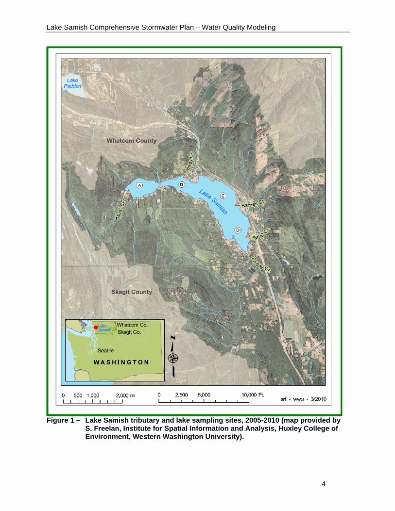
Calibration of the constructed model was performed by comparing the model outputs to existing water quality data collected by Western Washington University (WWU) during their ongoing study of the basin. For additional information regarding this WWU study and its findings, reference Study WQ-D (2005-present) in the technical memorandum Water Quality Monitoring – Review of Historical Monitoring and Recommendations for Future Monitoring Programs (dated October 7, 2010) prepared by Wilson Engineering LLC for this project. This study’s stream monitoring program included monitoring on four influent streams (Mia Creek, Mud Creek, Finney Creek and Barnes Creek) and on the Friday Creek outlet. Figure 1 details the locations of the WWU lake monitoring stations A, B, C, and D and the stream monitoring stations from this study. Model Limitations There are a number of caveats and limitations associated with the LAKE2K model that should be kept in mind when considering the accuracy of the Lake Samish model results. The model gives only an approximation of water quality; and thus predictions can only be used in light of the uncertainty due to errors in either the model structure or the calibrated parameters. Limitations which should be considered in evaluating this modeling effort include:
• The model’s predictions assume that future forcing functions (e.g., loading, meteorology, tributary flows, settling fluxes) can be reasonably extrapolated from prior data.
• The model simulates water quality as whole-lake, average concentrations. Any
horizontal gradients in stratification, mixing, internal loading, and water quality would not be accounted for by LAKE2k.
• The phosphorus loading inputs for the model were either inorganic phosphorus or organic phosphorus without distinguishing bioavailability. Organic phosphorus represents the phosphorus tied up in the lake’s biomass and is, therefore, not available for uptake. Inorganic phosphorus represents the phosphorus which is available for uptake.
• The model simulated the lake as a one-dimensional system consisting of three vertical
layers (Figure 3). The volumes of the two deeper layers (metalimnion and hypolimnion) are held fixed whereas the epilimnion was allowed to change as a function of the balance between inflows and outflows. This is an oversimplification that can add to the existing error in the model compared to models which allow varying hypolimnion depth.
Lake Samish Comprehensive Stormwater Plan – Water Quality Modeling
4
Figure 1 – Lake Samish tributary and lake sampling sites, 2005-2010 (map provided by
S. Freelan, Institute for Spatial Information and Analysis, Huxley College of Environment, Western Washington University).
Lake Samish Comprehensive Stormwater Plan – Water Quality Modeling
5
• The LAKE2K model of Lake Samish is only useful in determining the relative effects of
relative changes in lake phosphorus loading. The precise phosphorus loading and other lake parameters are only estimates from limited data or extrapolated from literature data. Therefore the model is best used to determine relative effects of changes in lake parameters rather than a model that precisely characterizes the lake dynamics.
Model Results Three modeling water quality scenarios were analyze mirroring the modeling scenarios performed for the hydrologic model. All of the scenarios modeled were for the two-year time period 2008-2009. The water quality scenarios modeled and their results are outlined below:
• Scenario #1 – Existing Land Use - Existing Conditions – The “existing conditions”
scenario modeled the current conditions in the watershed utilizing existing land use and development flows and water quality conditions. Model runs were performed for both the West and East Arms of the lake.
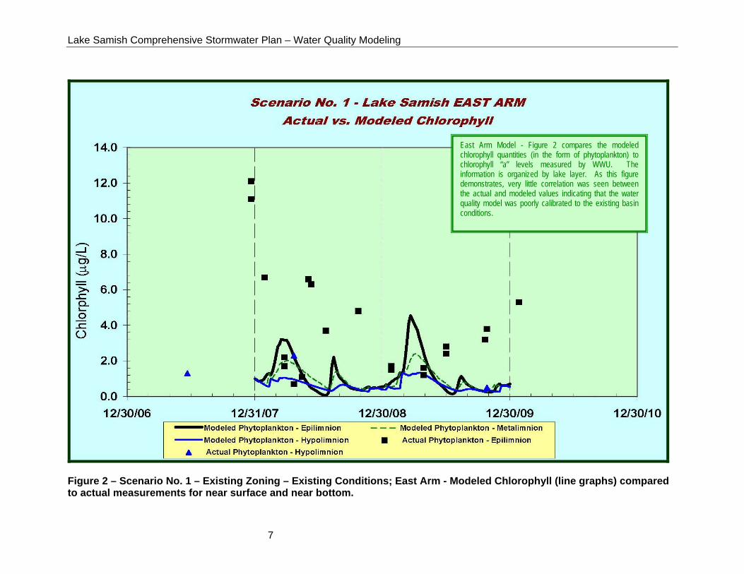
For this scenario, the amount of total chlorophyll modeled for the lake was compared to the amount of chlorophyll “a” measured during the WWU study as an indicator of overall water quality. In addition, comparisons were made between other parameters measured during the WWU study including; dissolved oxygen, phosphorus, and nitrogen. - Chlorophyll (function of phytoplankton) - The model under-predicts phytoplankton
(and thus chlorophyll) peak values for the East Arm (Figure 2) and only provides intermittent agreement with the existing West Arm data..
- Dissolved Oxygen - The modeled dissolved oxygen data only generally follows the actual data for the East and West Arms of the lake. The existing WWU data for the East Arm data indicates that there is more mixing in the East Arm than modeled, and the LAKE2K model is not equipped to consider diurnal changes in wind which could in turn underestimate the mixing energy. This “insufficient” mixing within the model may account for some of the discrepancy between the model and the existing data.
- Phosphorus - The modeled total phosphorus data provides only general agreement with the existing WWU data. The modeled inorganic phosphorus and organic phosphorus data, however, are not directly comparable to actual data. In reality, the modeled inorganic phosphorus data are probably overestimated, while the modeled organic phosphorus is most likely underestimated. A few possible reasons for this inaccuracy could be; o an incomplete understanding of existing conditions in the lake due to data gaps, o conditions within the model do not allow for variation of the hypolimnion depth, o the influent load ratio of inorganic to organic phosphorus in the lake may be smaller
than modeled, and o inorganic phosphorus uptake by the phytoplankton may be greater than modeled.
For the sake of brevity, only a graph comparing total chlorophyll and chlorophyll “a” in the East Arm has been included in this technical memorandum, (reference Figure 2). As demonstrated in this figure, results from Scenario #1 showed insufficient agreement

Lake Samish Comprehensive Stormwater Plan – Water Quality Modeling
6
between the existing and modeled conditions to establish the constructed model as a reliable predictive tool. Similar results were found for the other parameters modeled.
• Scenario #2 – Future Land Use – Build-out Conditions - The “build-out” scenario
considered land use and land cover changes based only on maximum development potential and resulting percent impervious increases as projected per Whatcom County 2010 zoning designations. Model runs were performed for both the West and East Arms of the lake.
• Scenario #3 – Differential Impacts of Timber Harvesting - The “timber harvesting” scenario in the West Arm assumed 43% of forest was harvested in Mud and Roy East/West sub-basins.
While both Scenario #2 and #3 were executed using the LAKE2K model, results from these scenarios were inconclusive with regard to their water quality predictions.
Lake Samish Comprehensive Stormwater Plan – Water Quality Modeling
7
Figure 2 – Scenario No. 1 – Existing Zoning – Existing Conditions; East Arm - Modeled Chlorophyll (line graphs) compared to actual measurements for near surface and near bottom.
East Arm Model - Figure 2 compares the modeled chlorophyll quantities (in the form of phytoplankton) to chlorophyll “a” levels measured by WWU. The information is organized by lake layer. As this figure demonstrates, very little correlation was seen between the actual and modeled values indicating that the water quality model was poorly calibrated to the existing basin conditions.

Lake Samish Comprehensive Stormwater Plan – Water Quality Modeling
8
Summary and Recommendations Summary The original goals of this analysis included (1) development of a simple mathematical model for water quality in Lake Samish focusing on phosphorus, algae, and dissolved oxygen and (2) use of this model to assess the effects of increased nutrient loadings associated with changing land uses and development. The purpose was to provide an objective tool for relating changes in nutrient loadings to potential changes in water quality in Lake Samish. At the onset of this work, it was acknowledged that the current body of water quality monitoring data for the Lake Samish Basin may be inadequate to support construction and calibration of a reliable water quality model for the area. As it turned out, these limitations in background monitoring data proved prohibitive, and a reliably predictive water quality model could not be built.
Recommendations Construction and calibration of a working water quality model which is sophisticated enough to accurately model a lake basin and provide consistent predictive information is difficult, costly, and time consuming. Before committing the money and resources required to develop such a model, a clear benefit must be identified. Historical water quality monitoring within the Lake Samish Basin has already confirmed the effects of external phosphorus loading to the lake as it relates to eutrophication and water quality. However, it is understood that the majority of this loading is non-point in nature. While a calibrated water quality model of the basin might be capable of simulating the potential, overall water quality impacts of future nutrient loading from the watershed, the results would only be relevant relative to current overall conditions. The model would be unable to positively correlate specific watershed activities to water quality changes in the lake except in a general fashion. For this reason, this planning effort does not recommend expending resources to develop a comprehensive water quality model for the Lake Samish Basin at this time. Instead, we re-emphasize the recommendation made in a previous memorandum regarding monitoring which calls for the development of a comprehensive, ongoing lake and tributary monitoring effort which can be used to establish a clearer picture of the basin’s baseline water quality condition.