samish final report final 9-29 - skagitcounty.net
TRANSCRIPT
Samish Bay Watershed Water Quality Monitoring Project
Final Report Introduction The Samish Bay Watershed Water Quality Monitoring Project was initiated to try to determine sources of shellfish contamination in Samish Bay, Skagit County, Washington. In 1988, under guidance from the ‘Nonpoint Rule’ WAC 400-12, the Samish Watershed was given third priority ranking for controlling non-point pollution in Skagit County. In August of 1994, an outbreak of gastro-intestinal illness related to shellfish consumption prompted the Washington State Department of Health Shellfish Office to downgrade shellfish growing areas in Samish Bay from ‘approved’ to ‘restricted’ and ‘prohibited’. Further investigation revealed elevated levels of fecal coliform associated with fresh water inputs into the bay, including the Samish River, Edison Slough, and Colony Creek. The Samish Watershed Plan was finished in 1995, and was also used as a Final Closure Response Strategy. It outlined objectives for addressing non-point pollution problems in the Samish Bay Watershed. In 1998, community sewers were installed in Blanchard and Edison, and resulted in the upgrading to ‘approved’ and ‘conditionally approved’ of a small amount of the original 2,700 acres of closed shellfish beds. More recently, most stations in Samish Bay have been upgraded to “approved” status. However, segments of Friday Creek, Samish River, and Samish Bay are on the 1998 303(d) list for fecal coliform. The Washington State standard for Class A surface fresh waters states that fecal coliform levels shall not exceed a geometric mean of 100 colonies/100 ml, and not have more than 10 percent of all samples obtained for calculating the geometric mean exceeding 200 colonies/100 ml. Sampling for the Samish Bay Watershed Water Quality Monitoring Project began in April, 2000, and continued into June, 2003. A full range of water quality parameters in addition to fecal coliform were measured at 24 sample sites in the Samish Basin and nearby independent drainages leading to Samish Bay.

2
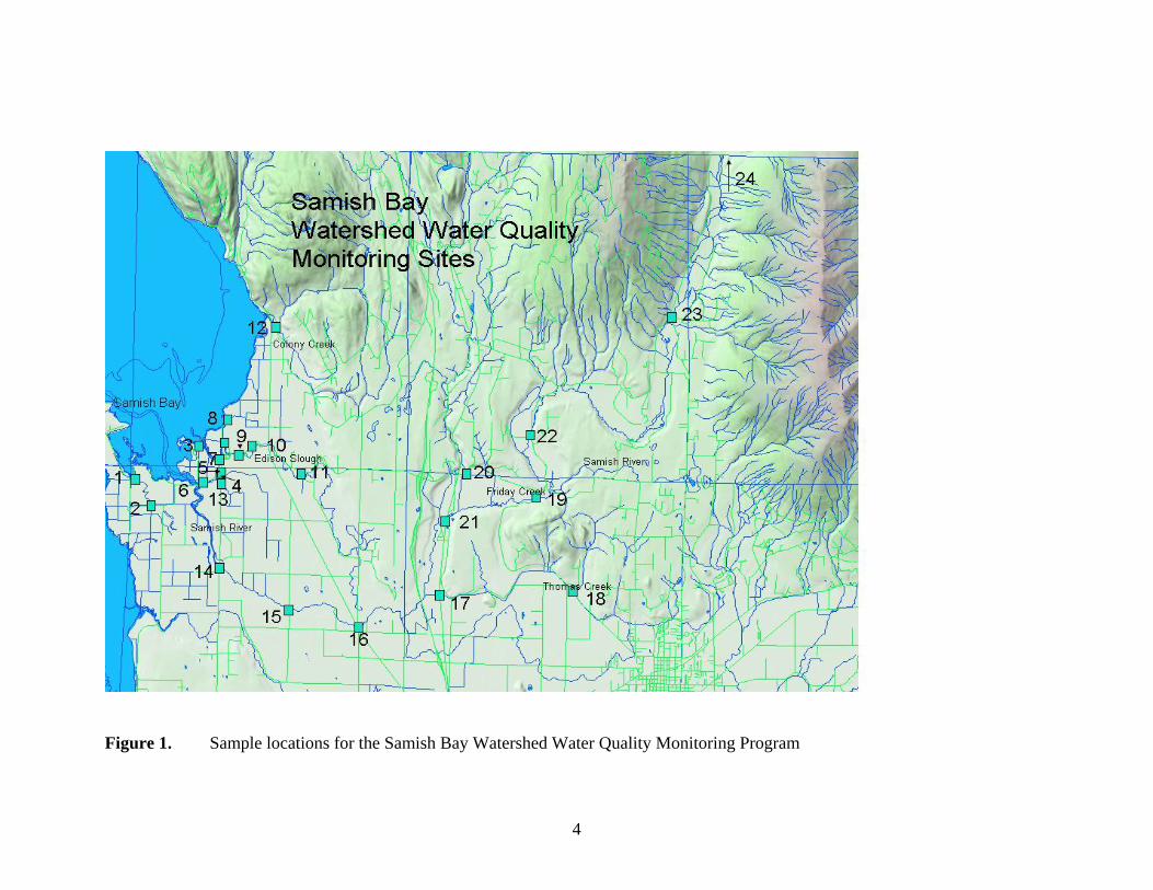
Operation of the project was aided by a Technical Advisory Committee (TAC) composed of water quality experts from around the region. Members were Doug Bulthuis (Padilla Bay National Estuarine Research Reserve), Bill Dewey (Taylor Shellfish Farms), Bob LaRock (Skagit System Cooperative), Britt Pfaff-Dunton (Skagit County Health Department), Kristi Carpenter (Skagit Conservation District), Lori Kyle (Skagit Conservation District), Jim Carver (Samish Tribe), Don Lennartson (Washington State Department of Health), and Kirk Buchanan (Washington Department of Fish and Wildlife). The TAC met on seven occasions between October, 1999 and July, 2003. The group helped plan the project prior to the initiation of monitoring, reviewed data collected, and provided input on interpretation of results and methods to address problems encountered with the monitoring. Methods Sample sites for the Samish Bay Watershed Water Quality Monitoring Project are listed in Table 1 and illustrated in Figure 1. Detailed descriptions of monitoring method can be found in the Quality Assurance Project Plan (Skagit County Public Works, 2000). Sample locations were divided into two types: ambient and problem. Most ambient sites were visited during each sampling trip (every two weeks) and a full range of parameters were analyzed, including nutrients. These sites were selected to provide data on both fecal coliform sources and general water quality. Problem sites were visited every other sampling trip (every four weeks), and no nutrient samples were taken. The problem sites were chosen specifically for further information on fecal coliform sources, although field water quality parameters such as dissolved oxygen, pH, and turbidity were also measured at problem sites. Parameters measured in the Samish Bay Water Quality Monitoring Project and the methods used are summarized in Table 2. Samples were collected, preserved, and stored as recommended in Puget Sound Protocols (Puget Sound Estuary Program 1996). Water samples were grab samples obtained with a sampling wand from the thalweg of the watercourse. These samples were used for fecal coliform, nutrients, Total Suspended Solids (TSS), turbidity, and pH. Duplicates were collected sequentially within a few seconds of the main samples. Fecal coliform samples were analyzed by the Skagit County Health Department, a state-accredited laboratory. Nutrient samples were analyzed by state-accredited private contract laboratories.

3
Table 1. Sample locations for the Samish Bay Watershed Water Quality Monitoring Project
Site Code Site No. Type* Site Description
Latitude
Longitude
ABPS1 1 A Alice Bay pump station 48.5552 -122.4833
ABSR1.0 2 P Alice Bay drainage at Samish Island Rd.
48.5482 -122.4759
ESMTG4 3 A Edison drainage near mouth of Edison Slough 48.5644 -122.4540
EBEW1 4 P Edison drainage at Bayview Edison Road, west 48.5547 -122.4516
EBEE2 5 P Edison drainage at Bayview Edison Road, east 48.5570 -122.4438
EFMN1 6 P Edison drainage at Farm to Market Road, north 48.5575 -122.4430
ESPSTG5 7 A near Edison - drainage channel 2 pump stations and 3 tide gates 48.5610 -122.4441
SBTG3 8 A near Samish Bay, tide gate and pump station 48.5718 -122.4405
ESSC1.5 9 A Edison Slough near school 48.5623 -122.4350 ESED3.0 10 P Edison Slough at East Edison Rd. 48.5647 -122.4286 ESBH4.0 11 A Edison Slough near Bow 48.5576 -122.4053 CCCR1.0 12 A Colony Creek near mouth 48.5971 -122.4185
EFMS2 13 P Edison drainage at Farm to Market Road, south 48.5546 -122.4429
SRFM3.0 14 A Samish River at Farm to Market 48.5319 -122.4431 SRTR4.5 15 A Samish River at Thomas Road 48.5211 -122.4100 SRCD6.5 16 A Samish River at Chuckanut Dr. 48.5169 -122.3772 TCH990.5 17 A Thomas Creek at Highway 99 48.5260 -122.3390 TCFS4.0 18 A Thomas Creek at F & S Grade Rd. 48.5279 -122.2761 SRFS12.5 19 A Samish River at F & S Grade Rd. 48.5529 -122.2944 FCPR1.0 20 A Friday Creek at Prairie Road 48.5586 -122.3271 SRH9910.0 21 A Samish River at Highway 99 48.5458 -122.3369 SRPR15.5 22 A Samish River at Prairie Road 48.5695 -122.2975 SRH921.0 23 A Samish River at Highway 9 48.6020 -122.2315 SRIR25.0 24 A Samish River near Innis Rd 48.6787 -122.1946
4
Figure 1. Sample locations for the Samish Bay Watershed Water Quality Monitoring Program

5
Table 2. Parameters measured in Samish Bay Watershed Water Quality Monitoring Project
Parameter Units(DL) Method Range Dissolved Oxygen mg/L (0.01) YSI 85 Dissolved Oxygen Meter 0 - 20 Temperature °C (1.0) YSI 85 Dissolved Oxygen Meter -10 to 110 Turbidity NTU (0.01) LaMotte 2020 Turbidity Meter 0 to 1100 pH pH (0.01) Fisher Accumet AP 62 pH Meter 0 to 14 Fecal Coliform colonies / 100
ml (NA) MPN - fresh water, 5 tube(SM 9221 E)
(analyzed by Skagit County Health Dept)
<2 to 2400
Conductivity uS/cm (0.01) YSI 85 Dissolved Oxygen Meter 0 to 4999 Salinity ppt (0.01) YSI 85 Dissolved Oxygen Meter 0 to 80 NO3, NH4, PO4, TP mg/L(0.1) EPA 300.0, 350.3, 265.2, 365.3 0.1 to UL1
Total Suspended Solids mg/L (1.0) EPA 160.2 1.0 to UL1
Velocity ft/s (0.1) Price type current meter 0.1 to 25 1 upper limit can be increased by dilution of sample Meters with sensors deployed directly in the thalweg were used for dissolved oxygen, temperature, conductivity, and salinity. Stream velocity and discharge were determined at selected locations using Price-type current meters and the area-velocity method. Discharge from a tide gate at a selected location was determined using a Sigma 950 flowmeter. Field data was recorded in waterproof notebooks or field data sheets. Field data, along with data from laboratory reports, were entered into the Skagit County Public Works Monitoring Database. Printouts from the database were compared with field sheets and lab reports for correct data entry. Errors were corrected in the database. Information from the database was exported to Excel spreadsheets for data summarization and analysis. The statistical software package Statistix was used for some analysis and generation of box-and-whisker plots, which illustrate the median, upper and lower quartiles, and extremes of a data set along with outlying data points. Means and geometric means were calculated by substituting a value of 2500 for those instances where the laboratory reported a value of “>2400.” These means must be treated with caution since we do not have information regarding the amount those values exceeded 2400. They are included here for the purposes of comparisons between sample stations.

6
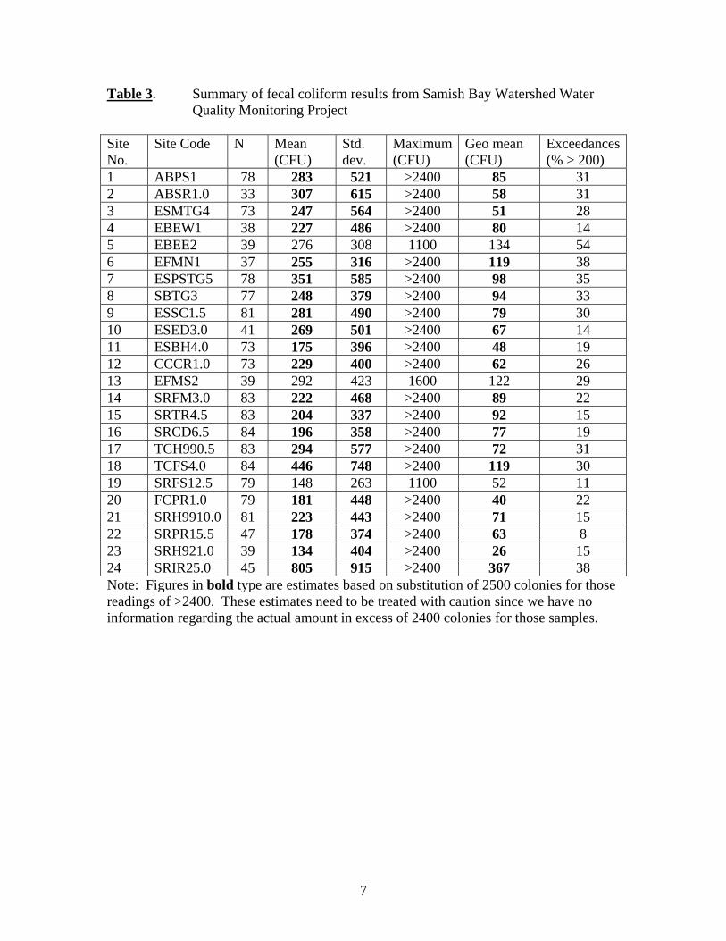
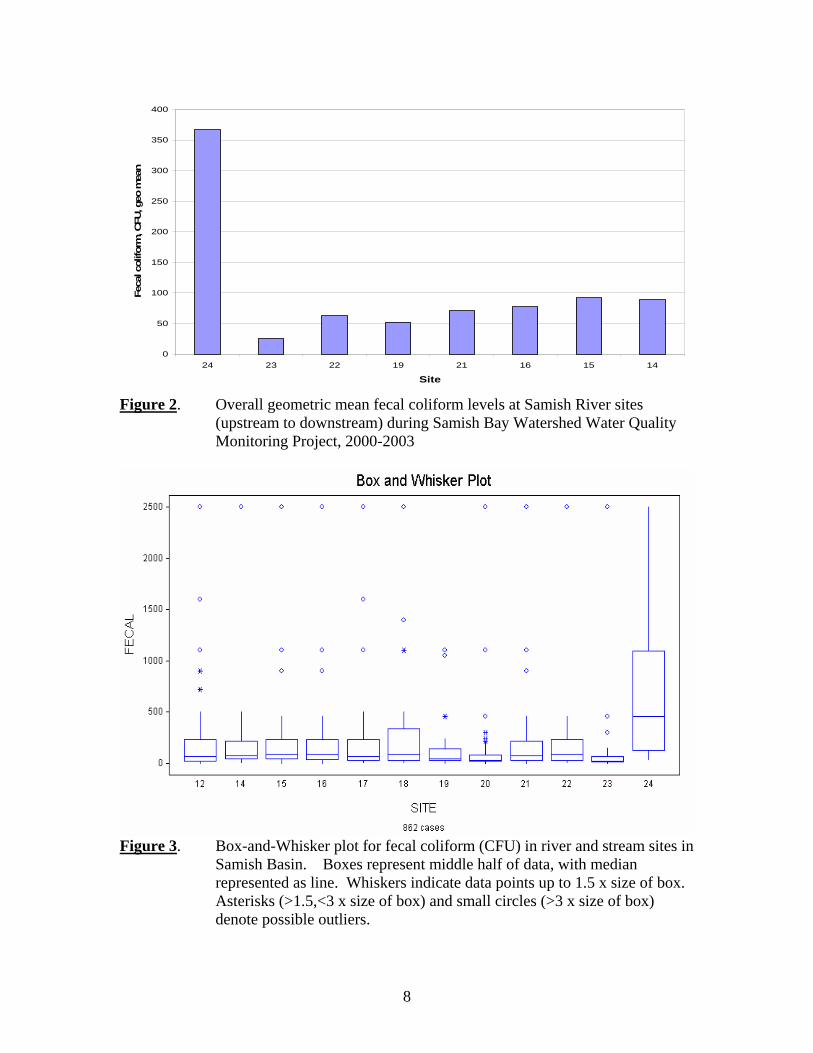
Results and Discussion Results from all of the samples taken during the project for each sample station are included in Appendix A. Summaries for each sample site including descriptive statistics are included as Appendix B. Fecal coliform A summary of fecal coliform results is provided in Table 3. Overall geometric means for the study period ranged from 25 colony forming units per 100 ml (CFU) for the Samish River at Highway 9 (Site 23) to 366 CFU for the Samish River near Innis Road (Site 24). The state water quality standard for these waters is 100 CFU. Site 23 is the next sample location downstream from Site 24, and it is interesting that the sites with the highest and lowest fecal coliform levels are so close together. Between the two sites, the river flows through a large wetland which may serve as a sink for coliform bacteria. Exceedances, the number of samples greater than 200 CFU for the last 12 months, range from 8 percent for the Samish River at Prairie Road (Site 22) to 54 percent for a portion of the Edison drainage (Site 5). The state standard (State of Washington 2003) for exceedances is less than 10 percent. Only one station in this study did not exceed that standard. Combining all data for the three years from the drainage and slough sites (Sites 1-11, 13) yields an arithmetic mean of 262 CFU, while the mean for the stream sites (Sites 12, 14-24) was 256 CFU. This indicates that in general, the stream sites had as much fecal coliform as the drainage infrastructure. Removal of Site 24 (the highest river site) from the river data yielded a mean of 225 CFU. The arithmetic mean was used for this part of the analysis because Excel software could not calculate geometric means for large data arrays. Overall geometric mean for the Samish River sites, from upstream to down, is illustrated in Figure 2. River sites showed a consistent pattern of high fecal coliform at the upstream station (24), very low coliform at the next station, then gradually increasing downstream. The same river data, plus the other stream stations (Friday, Thomas, and Colony Creeks) is displayed in box-and-whisker format in Figure 3. This data suggests that except for the furthest upstream site, there are no sites that show consistent large influxes of fecal coliform. This concept was confirmed by examination of the pattern of coliform levels from individual sample dates (Figure 4). The station with the highest coliform levels changed from sample date to sample date, and no one station showed a consistent input of coliform bacteria. This suggests that other than at the furthest upstream station, there is no consistent source of fecal coliform to the Samish River, and that the observed coliform levels stem from transient sources rather than consistent practices.
7
Table 3. Summary of fecal coliform results from Samish Bay Watershed Water Quality Monitoring Project Site No.
Site Code N Mean (CFU)
Std. dev.
Maximum (CFU)
Geo mean (CFU)
Exceedances (% > 200)
1 ABPS1 78 283 521 >2400 85 31 2 ABSR1.0 33 307 615 >2400 58 31 3 ESMTG4 73 247 564 >2400 51 28 4 EBEW1 38 227 486 >2400 80 14 5 EBEE2 39 276 308 1100 134 54 6 EFMN1 37 255 316 >2400 119 38 7 ESPSTG5 78 351 585 >2400 98 35 8 SBTG3 77 248 379 >2400 94 33 9 ESSC1.5 81 281 490 >2400 79 30 10 ESED3.0 41 269 501 >2400 67 14 11 ESBH4.0 73 175 396 >2400 48 19 12 CCCR1.0 73 229 400 >2400 62 26 13 EFMS2 39 292 423 1600 122 29 14 SRFM3.0 83 222 468 >2400 89 22 15 SRTR4.5 83 204 337 >2400 92 15 16 SRCD6.5 84 196 358 >2400 77 19 17 TCH990.5 83 294 577 >2400 72 31 18 TCFS4.0 84 446 748 >2400 119 30 19 SRFS12.5 79 148 263 1100 52 11 20 FCPR1.0 79 181 448 >2400 40 22 21 SRH9910.0 81 223 443 >2400 71 15 22 SRPR15.5 47 178 374 >2400 63 8 23 SRH921.0 39 134 404 >2400 26 15 24 SRIR25.0 45 805 915 >2400 367 38 Note: Figures in bold type are estimates based on substitution of 2500 colonies for those readings of >2400. These estimates need to be treated with caution since we have no information regarding the actual amount in excess of 2400 colonies for those samples.
8
0
50
100
150
200
250
300
350
400
24 23 22 19 21 16 15 14
Site
Feca
l col
iform
, CFU
, geo
mea
n
Figure 2. Overall geometric mean fecal coliform levels at Samish River sites (upstream to downstream) during Samish Bay Watershed Water Quality Monitoring Project, 2000-2003
Figure 3. Box-and-Whisker plot for fecal coliform (CFU) in river and stream sites in Samish Basin. Boxes represent middle half of data, with median represented as line. Whiskers indicate data points up to 1.5 x size of box. Asterisks (>1.5,<3 x size of box) and small circles (>3 x size of box) denote possible outliers.

9
0.00
20.00
40.00
60.00
80.00
100.00
120.00
24 23 22 19 21 16 15 14Site
Feca
l col
iform
, CFU
3/18/20034/15/20035/18/2003
Figure 4. Samish River fecal coliform levels from upstream to downstream for three sample dates during the Samish Bay Watershed Water Quality Monitoring Project. Overall geometric mean for the slough and drainage ditch sites is shown in Figure 5. These sites showed extremely variable amounts of fecal coliform. Sites 11, 10, and 9 are in Edison Slough (upstream to downstream) and show increasing levels of fecal coliform in the downstream direction. The same data is displayed in box-and-whisker format in Figure 6.
0
20
40
60
80
100
120
140
160
1 2 3 4 5 6 7 8 9 10 11 13
Site
Feca
l col
iform
, CFU
, geo
mea
n
Figure 5. Overall geometric mean fecal coliform levels at slough and drainage ditch sites during Samish Bay Watershed Water Quality Monitoring Project, 2000-2003

10
Figure 6. Box-and-Whisker plot of fecal coliform levels (CFU) for slough sample sites in Samish Basin. Boxes represent middle half of data, with median represented as line. Whiskers indicate data points up to 1.5 x size of box. Asterisks (>1.5,<3 x size of box) and small circles (>3 x size of box) denote possible outliers. Figure 7 shows an upstream-downstream analysis for the most recent samples from sites on Edison Slough. Again, there is no clear indication of a site that consistently shows the highest coliform levels, although there is a suggestion that Site 10 could have a repeated source in the area. This pattern was not repeated over time, however, as Site 9 has the highest geometric mean over the life of the study. This again suggests transient sources are the main contributors of fecal coliform to Edison Slough. Figure 8 illustrates the overall geometric mean for all samples taken on a given date. This graph is intended to help determine the seasonality of fecal coliform contamination in the Samish Basin. The data suggest that peak coliform levels usually occur in the late spring and early summer. Additional sampling in the area during the summer of 2003 conducted as part of the Skagit County Baseline Monitoring Program showed that high fecal coliform levels again occurred in late spring and early summer in Samish River stations. This graph also suggests that there is no apparent long-term trend in coliform levels in the Samish watershed. Summer peaks in 2002 and 2003 were lower than 2001, but higher than 2000.

11
0.00
20.00
40.00
60.00
80.00
100.00
120.00
140.00
160.00
180.00
ESBH4.0 Site 11 ESED3.0 Site 10 ESSC1.5 Site 9
Site
Feca
l col
iform
, CFU
3/4/20034/1/20034/29/20035/27/2003
Figure 7. Edison Slough fecal coliform levels from upstream to downstream for four sample dates during the Samish Bay Watershed Water Quality Monitoring Project.
0
500
1000
1500
2000
2500
4/26
/00
6/5/
00
7/18
/00
8/29
/00
10/1
0/00
11/2
0/00
1/2/
01
2/20
/01
4/3/
01
5/15
/01
6/27
/01
8/7/
01
9/18
/01
10/3
0/01
12/1
1/01
1/22
/02
3/5/
02
4/16
/02
5/28
/02
7/9/
02
8/20
/02
10/1
/02
11/1
2/02
12/1
2/02
1/23
/03
3/4/
03
4/15
/03
5/27
/03
Date
Feca
l col
iform
, geo
met
ric m
ean,
CFU
Figure 8. Overall geometric mean fecal coliform for all sites by date for Samish Basin Water Quality Monitoring Project

12
Figure 9 shows coliform results for Site 14, the Samish River at Farm-to-Market Road. This is the furthest downstream site on the Samish River in this study. Except for some relatively high coliform counts in the winter of 2000, this station showed the highest counts in the late spring and summer, similar to the overall pattern. Figure 10 illustrates coliform levels over time for Site 1, the Alice Bay Pump station. This site also shows maximum coliform levels in the late spring and summer.
0
500
1000
1500
2000
2500
3000
Apr-00
Jun-
00
Aug-
00
Oct
-00
Dec
-00
Feb-
01
Apr-01
Jun-
01
Aug-
01
Oct
-01
Dec
-01
Feb-
02
Apr-02
Jun-
02
Aug-
02
Oct
-02
Dec
-02
Feb-
03
Apr-03
Date
Feca
l col
iform
, CFU
Figure 9. Fecal coliform sample results over time for Samish River at Farm-to- Market Road (Site 14).
0
500
1000
1500
2000
2500
3000
4/26
/00
6/26
/00
8/26
/00
10/2
6/00
12/2
6/00
2/26
/01
4/26
/01
6/26
/01
8/26
/01
10/2
6/01
12/2
6/01
2/26
/02
4/26
/02
6/26
/02
8/26
/02
10/2
6/02
12/2
6/02
2/26
/03
4/26
/03
Date
Feca
l col
iform
, CFU
Figure 10. Fecal coliform sample results over time for Alice Bay Pump Station (Site 1).

13
Figure 11 shows coliform results for the Samish River near Innis Road (Site 24), which had the highest geometric mean coliform levels of any site in the study. There is no apparent seasonality to the coliform levels at this site, as high readings occurred in both winter and summer.
0
500
1000
1500
2000
2500
3000
Apr-0
0
Jun-
00
Aug
-00
Oct
-00
Dec
-00
Feb-
01
Apr-0
1
Jun-
01
Aug
-01
Oct
-01
Dec
-01
Feb-
02
Apr-0
2
Jun-
02
Aug
-02
Oct
-02
Dec
-02
Feb-
03
Apr-0
3
Date
Feca
l col
iform
, CFU
Figure 11. Fecal coliform sample results over time for Samish River at Innis Creek Road (Site 24). Figures 12 and 13 illustrate fecal coliform samples taken before and after periods of concentrated rainfall. These graphs illustrate the potential for coliform increases as a result of rainfall. At most stations, fecal coliform levels increased markedly after the rainfall compared with samples taken within 48 hours before the rainstorm. However, analysis of rainfall events did not explain all the coliform spikes seen in this study. In some cases, high coliform levels appeared without rainstorms. In others, some stations did not have high coliform levels after significant rain. While it is clear from Figures 12 and 13 that rainfall events can have an effect on coliform levels, that effect is not guaranteed for every station and rainfall event.

14
0
100
200
300
400
500
600
1 3 8 9 12 14 15 16 17 18 19 20 21
Site
Feca
l col
iform
(CFU
)
12/10/200212/12/2002
Geo mean 1/21 = 40 1/23 = 135
Rainfall = 0.44 on 12/11-12
Figure 12. Pre- and Post-rainfall fecal coliform samples for December 2002, for selected sites in the Samish Basin Water Quality Project.
0.00
200.00
400.00
600.00
800.00
1,000.00
1,200.00
1,400.00
1,600.00
1,800.00
1 3 7 8 9 11 12 14 15 16 17 18 19 20 21
Site
Feca
l col
iform
(FC
U)
1/21/20031/23/2003
Geo mean 1/21 = 19 1/23 = 284
Rainfall = 0.75 on 1/21-22
Figure 13. Pre- and Post rainstorm samples for January, 2003, for selected sites in Samish Bay Watershed Water Quality Monitoring Project.

15
Figure 14 represents a comparison of fecal coliform samples and their duplicates for Site 16, the Samish River at Chuckanut Drive. Note the occasional disparity between samples and duplicates. The comparisons charted here yielded a mean difference of 121 percent between samples and their duplicates, with a median of 78 percent. These results and similar results from other sample sites led Skagit County to conduct a small experiment to attempt to pinpoint the source of variability in fecal coliform samples. Results of the experiment are included as Appendix C. Results from this experiment suggest that a significant portion of the overall variability in fecal coliform analyses may occur in the laboratory. The existence of significant amounts of variability in coliform sample results indicates that individual coliform readings need to be considered carefully before being used for characterization of sample locations. This points out the need to consider long-term performance at a given site in assessing the condition of that site. For the purposes of summary statistics and charting for this study, the samples labeled as originals were used in all cases. Samples labeled as duplicates were used only for indications of variability.
0
200
400
600
800
1000
1200
4/26
/00
6/26
/00
8/26
/00
10/2
6/00
12/2
6/00
2/26
/01
4/26
/01
6/26
/01
8/26
/01
10/2
6/01
12/2
6/01
2/26
/02
4/26
/02
6/26
/02
8/26
/02
10/2
6/02
12/2
6/02
2/26
/03
Sample date
Feca
l col
iform
, CFU
Fecal ColiformDuplicate
Figure 14. Comparison of fecal coliform samples and duplicates for Samish River at Chuckanut Drive during Samish Bay Watershed Water Quality Monitoring Project. Fecal coliform loading to Samish Bay from the Samish River is illustrated in Figure 15. This graph shows the estimated number of coliform colonies per day reaching Samish

16
Bay, based on discharge measurements and coliform levels at the sample station at Chuckanut Drive (Site 16). This is the furthest downstream station with discharge data due to tidal interference at stations further downstream. From these data it is estimated that the Samish River supplies an average of 3 x 10¹² coliform colonies per day to Samish Bay. Loading from a tide gate near Edison (Site 7) was also calculated based on estimated flows through the tide gate (recorded on a flow meter) and the coliform levels detected there. Through this method it is estimated that this tide gate supplies an average of 7 x 10⁹ coliform colonies per day to Samish Bay. By extending this estimate to the other tide gates and pump stations discharging to Samish Bay, it is estimated that the Samish River provides over 90 percent of the fecal coliform organisms to Samish Bay. This estimate is based on assumptions that the Site 7 tide gate is typical, and that the pump stations and tide gates discharge roughly equivalent amounts of water. Skagit County is in the process of confirming those assumptions, but based on this preliminary assessment, it appears that the Samish River is the primary freshwater source of fecal coliform colonies to Samish Bay.
0
1E+13
2E+13
3E+13
4E+13
5E+13
6E+13
7E+13
9/25
/00
10/2
5/00
11/2
5/00
12/2
5/00
1/25
/01
2/25
/01
3/25
/01
4/25
/01
5/25
/01
6/25
/01
7/25
/01
8/25
/01
9/25
/01
10/2
5/01
11/2
5/01
12/2
5/01
1/25
/02
2/25
/02
3/25
/02
4/25
/02
5/25
/02
6/25
/02
7/25
/02
8/25
/02
9/25
/02
10/2
5/02
11/2
5/02
12/2
5/02
1/25
/03
2/25
/03
3/25
/03
4/25
/03
5/25
/03
Date
Feca
l col
iform
, num
ber/d
ay
Mean loading = 3.2 e12 coliform colonies per day
Figure 15. Estimated fecal coliform loadings to Samish Bay from the Samish River. Determining the sources of fecal coliform in the Samish Basin is hampered by the lack of a Microbial Source Tracking (MST) program. Such a program could compare coliform strains from the water with those cultured from fecal samples to give an indication of origin of fecal coliform from water samples. Without such a program, we are unable to
17
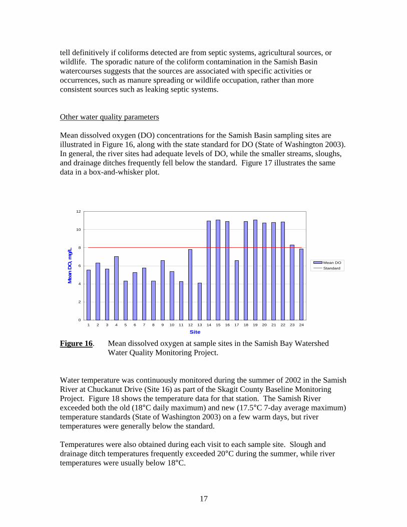
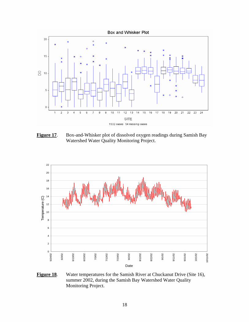
tell definitively if coliforms detected are from septic systems, agricultural sources, or wildlife. The sporadic nature of the coliform contamination in the Samish Basin watercourses suggests that the sources are associated with specific activities or occurrences, such as manure spreading or wildlife occupation, rather than more consistent sources such as leaking septic systems. Other water quality parameters Mean dissolved oxygen (DO) concentrations for the Samish Basin sampling sites are illustrated in Figure 16, along with the state standard for DO (State of Washington 2003). In general, the river sites had adequate levels of DO, while the smaller streams, sloughs, and drainage ditches frequently fell below the standard. Figure 17 illustrates the same data in a box-and-whisker plot.
0
2
4
6
8
10
12
1 2 3 4 5 6 7 8 9 10 11 12 13 14 15 16 17 18 19 20 21 22 23 24
Site
Mea
n D
O, m
g/L
Mean DOStandard
Figure 16. Mean dissolved oxygen at sample sites in the Samish Bay Watershed Water Quality Monitoring Project. Water temperature was continuously monitored during the summer of 2002 in the Samish River at Chuckanut Drive (Site 16) as part of the Skagit County Baseline Monitoring Project. Figure 18 shows the temperature data for that station. The Samish River exceeded both the old (18°C daily maximum) and new (17.5°C 7-day average maximum) temperature standards (State of Washington 2003) on a few warm days, but river temperatures were generally below the standard. Temperatures were also obtained during each visit to each sample site. Slough and drainage ditch temperatures frequently exceeded 20°C during the summer, while river temperatures were usually below 18°C.
18
Figure 17. Box-and-Whisker plot of dissolved oxygen readings during Samish Bay Watershed Water Quality Monitoring Project.
0
2
4
6
8
10
12
14
16
18
20
22
5/24
/02
6/3/
02
6/13
/02
6/23
/02
7/3/
02
7/13
/02
7/23
/02
8/2/
02
8/12
/02
8/22
/02
9/1/
02
9/11
/02
9/21
/02
10/1
/02
10/1
1/02
Date
Tem
pera
ture
(C)
Figure 18. Water temperatures for the Samish River at Chuckanut Drive (Site 16), summer 2002, during the Samish Bay Watershed Water Quality Monitoring Project.

19
Mean turbidities for the Samish Basin sites are illustrated in Figure 19. Turbidities were generally higher in the sloughs and drainage ditches than in the river and stream sites. Slough and ditch turbidities may occasionally be elevated due to algal blooms rather than eroding sediments. State turbidity standards are based on differences from background levels, and the Samish Basin study was not designed to focus on those differences.
0
5
10
15
20
25
30
35
40
1 2 3 4 5 6 7 8 9 10 11 12 13 14 15 16 17 18 19 20 21 22 23 24
Site
Turb
idity
, NTU
Figure 19. Mean turbidity at sample sites in the Samish Bay Watershed Water Quality Monitoring Project. Mean nutrient values from the Samish Basin study are illustrated in Figure 20. Orthophosphate, nitrate, and ammonia values tended to be higher in the sloughs and ditches. There are currently no state numeric standards for nutrients except ammonia toxicity. A spot check revealed that many of the ammonia levels recorded in this study, in both sloughs and river sites, exceeded the state ammonia chronic toxicity standard. In addition, the nitrate values are higher for each station than the regional nutrient criteria developed by EPA (USEPA 2000).

20
0.00
0.50
1.00
1.50
2.00
2.50
1 3 7 8 9 11 12 14 15 16 17 18 19 20 21 22 23 24
Site
Con
cent
ratio
n, m
g/L
as N
or P
Orthophosphate
Nitrate
Ammonia
Figure 20. Mean nutrient values at sample sites in the Samish Bay Watershed Water Quality Monitoring Project. Summary and Conclusions The Samish Bay Watershed Water Quality Monitoring Project successfully monitored a full suite of water quality parameters in the basin for over three years. Although fecal coliform contamination was the driving force behind the study, the Project gathered data for a wide range of water quality parameters. Samish Bay is recovering, as evidenced by the removal of shellfish restrictions from most areas in the bay. This recovery was certainly aided by community sewer improvements in Edison and Blanchard. However, river, slough, and drainage sites still occasionally exceed state standards for coliform and continue to supply coliform organisms to Samish Bay. Coliform sources seem to be transient in that most stations have wide fluctuations. A station showing the highest coliform during one sample may have the lowest in the next sample. One station on the upper Samish River was consistently high, but apparently did not influence the amount of coliform bacteria reaching Samish Bay, and no other stations were either consistently high or low. There was a tendency for coliform numbers to be higher in late spring and early summer. The transient nature of the coliform peaks suggest that they could be associated with particular short-term land use activities, such as application of manure to fields, wildlife activity, or movement of livestock to new pastures. Lack of consistency suggests that leaking septic systems are not responsible for the coliform peaks.

21
Preliminary loading calculations indicate that the Samish River is the largest source of coliform to Samish Bay. While the sloughs and drainages occasionally have high coliform counts, the river’s flow and only slightly lower counts appear to supply more bacteria to the bay. Coliform sampling variability appears to be high, based on analysis of duplicates taken during the sampling. A simple experiment suggested, although not definitively, that a large part of the variability may be associated with the laboratory procedures (See Appendix C. The project also provided evidence of substandard water quality for other parameters. Dissolved oxygen was frequently below state standards, especially in the drainage infrastructure. Temperature standards were exceeded in both the Samish River and the sloughs and drainages. Ammonia levels throughout the basin may exceed state chronic toxicity standards and nutrient levels exceed EPA regional criteria. Segments of the Samish River and Friday Creek were placed on the 1998 ECY 303(d) list for excess fecal coliform. Although Friday Creek and all but the uppermost site on the Samish maintain coliform geometric means below the state water quality standard (100 cfu), most stations still have more readings in excess of 200 cfu than the standard allows. One of the goals of the study was to assess the suitability of the Samish Basin for spawning and rearing of salmonids with respect to water quality. This study shows that the mainstem Samish River is in reasonable shape for salmonid use. Temperatures in the river, although occasionally venturing above the 18°C standard, were generally much lower and were not over the standard except for a few hours on the warmest days. Dissolved oxygen was also usually above the state standard, and turbidities in the river were generally low. However, substandard water quality remains a possible limiting factor to salmonid use of some smaller streams in the Samish Basin. High temperatures and low dissolved oxygen were found in Colony, Thomas and Friday Creeks, Edison Slough, and the uppermost reaches of the Samish River. The sites located in the drainage infrastructure, although more frequently in violation of water quality standards, were located upstream of tide gates or pump stations and are not considered salmonid habitat. This report should serve as an indicator that while progress has been made towards reducing fecal coliform levels in Samish Bay, the freshwater portions of the basin continue to record coliform levels in excess of state standards. Addressing the sources of coliform in the freshwater system may require a Microbial Source Tracking (MST) program. This report will be forwarded to the Skagit Conservation District to inform them of the status of coliform contamination in the Samish basin. The Conservation District works
22
cooperatively with the agricultural community to reduce impacts of agricultural activities on local ecosystems. Monitoring of fecal coliform and other water quality parameters will continue in the Samish Bay watershed as part of the Skagit County Monitoring Program. This program, an extension of the Skagit County Baseline Monitoring Program as delineated in Skagit County Resolution No. R20030210, will select sample sites in both the Samish River and the drainage infrastructure. The data collected in the Samish Bay Watershed project will be used in conjunction with data developed in the new program. Monitoring is scheduled to begin in October, 2003.

23
References Puget Sound Estuary Program (1996), “Recommended Protocols for Measuring Environmental Variables in Puget Sound,” (Puget Sound Protocols). Puget Sound Action Team, Olympia, WA. Skagit County Public Works (2000), “Samish Bay Watershed Water Quality Monitoring Project Quality Assurance Project Plan,” Centennial Clean Water Grant No. G0000258, Mount Vernon, WA. State of Washington (2003), Chapter 173-201A WAC, “Water Quality Standards for Surface Waters of the State of Washington,” Olympia, WA. USEPA (2000), “Ambient Water Quality Criteria Recommendations, Information Supporting the Development of State and Tribal Nutrient Criteria, Rivers and Streams in Nutrient Ecoregion II,” EPA 822-B-00-015.