lake sarah outlet
TRANSCRIPT

(27-191)
Hennepin County
LAKELAKELAKELAKELAKESARAH
OUTLET INVESTIGATION
December 2003
DNR
Waters

Equal opportunity to participate in and benefit fromprograms of the Minnesota Department of Natural
Resources is available to all individuals regardless of race,color, national origin, sex, sexual orientation, maritalstatus, status with regard to public assistance, age ordisability. Discrimination inquiries should be sent to:
MN/DNR, 500 Lafayette Road, St. Paul, MN 55155-4031; orthe Equal Opportunity Office, Department of the Interior,
Washington, D.C. 20240.
The DNR Information Center phone numbers:Twin Cities: (651) 296-6157
MN Toll Free: 1-888-646-6367 (or 888-MINNDNR)Telecommunication Device for the Deaf:
(651) 296-5484MN Toll Free: 1-800-657-3929
World Wide Web Address:http://www.dnr.state.mn.us/waters
This information is available in analternative format upon request
© 2003 State of Minnesota, Department of Natural Resources
Printed on Recycled Paper

Lake Sarah (27-191) Hennepin County
Outlet Investigation* December 2003
Introduction Lake Sarah has been experiencing higher lake levels for several years. The lake has been consistently above its Ordinary High Water (OHW) level since regular lake level readings have been kept since 1994. The DNR Waters Area Hydrologist and the Cities of Greenfield and Independence have received numerous high water complaints, primarily in regard to shoreline erosion and yard damage from higher lake levels. The outlet is located at the northwest end of the lake and flows through a relatively flat wetland/upland reach, eventually reaching the Crow River, approximately two miles downstream of Lake Sarah (Figure 1). The current runout is located at an abandoned railroad grade. The City of Greenfield produced plans to excavate sediment from a 3100-foot reach of the outlet channel to minimize higher water conditions. Concerns about the potential of this proposal to excessively lower lake levels, and impact a protected wetland (27-365W) immediately downstream of Lake Sarah, prompted this investigation.
Figure 1
*Prepared by: James A. Solstad DNR Waters [email protected]
DNR Waters Lake Sarah Outlet Investigation
2
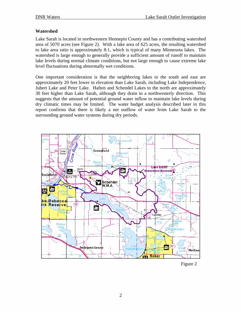
Watershed Lake Sarah is located in northwestern Hennepin County and has a contributing watershed area of 5070 acres (see Figure 2). With a lake area of 625 acres, the resulting watershed to lake area ratio is approximately 8:1, which is typical of many Minnesota lakes. The watershed is large enough to generally provide a sufficient amount of runoff to maintain lake levels during normal climate conditions, but not large enough to cause extreme lake level fluctuations during abnormally wet conditions. One important consideration is that the neighboring lakes to the south and east are approximately 20 feet lower in elevation than Lake Sarah, including Lake Independence, Jubert Lake and Peter Lake. Haften and Schendel Lakes to the north are approximately 30 feet higher than Lake Sarah, although they drain in a northwesterly direction. This suggests that the amount of potential ground water inflow to maintain lake levels during dry climatic times may be limited. The water budget analysis described later in this report confirms that there is likely a net outflow of water from Lake Sarah to the surrounding ground water systems during dry periods.
Figure 2
DNR Waters Lake Sarah Outlet Investigation
3
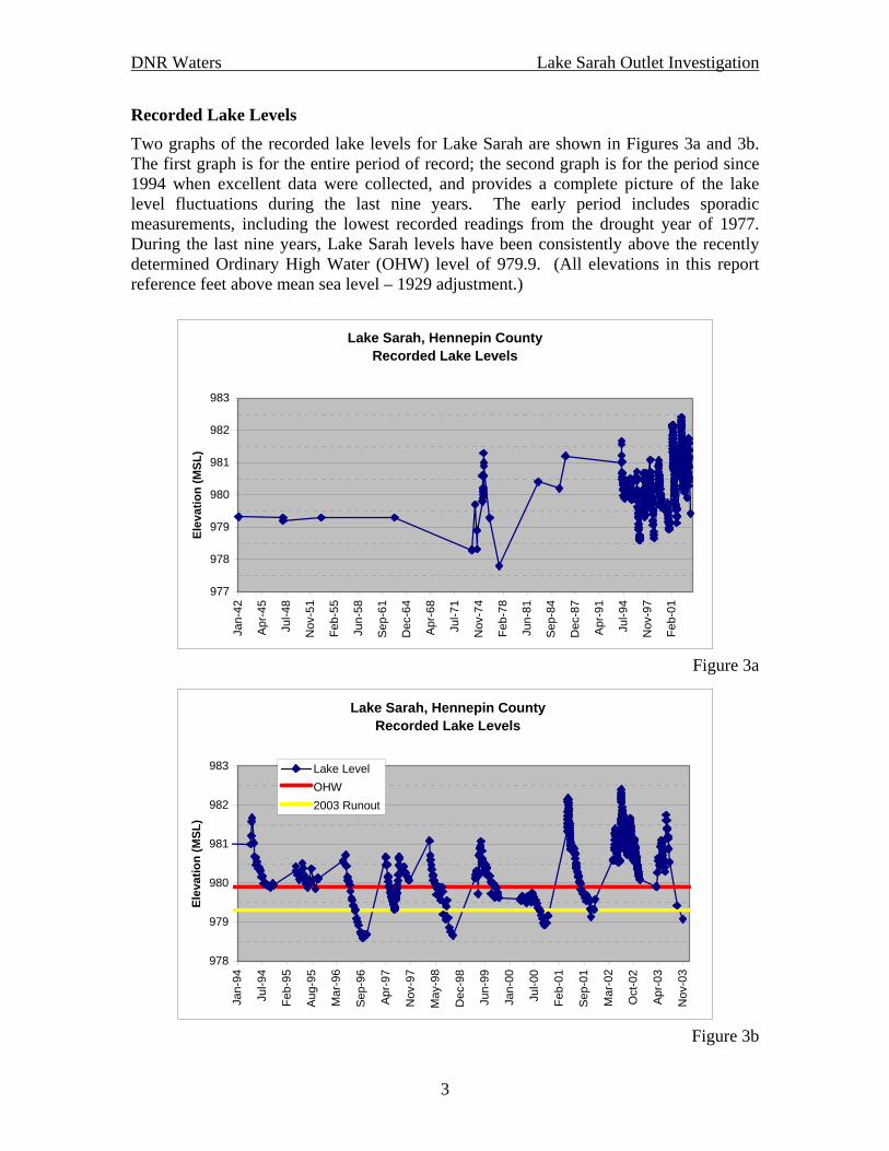
Recorded Lake Levels Two graphs of the recorded lake levels for Lake Sarah are shown in Figures 3a and 3b. The first graph is for the entire period of record; the second graph is for the period since 1994 when excellent data were collected, and provides a complete picture of the lake level fluctuations during the last nine years. The early period includes sporadic measurements, including the lowest recorded readings from the drought year of 1977. During the last nine years, Lake Sarah levels have been consistently above the recently determined Ordinary High Water (OHW) level of 979.9. (All elevations in this report reference feet above mean sea level – 1929 adjustment.)
Lake Sarah, Hennepin CountyRecorded Lake Levels
977
978
979
980
981
982
983
Jan-
42
Apr-4
5
Jul-4
8
Nov
-51
Feb-
55
Jun-
58
Sep-
61
Dec
-64
Apr-6
8
Jul-7
1
Nov
-74
Feb-
78
Jun-
81
Sep-
84
Dec
-87
Apr-9
1
Jul-9
4
Nov
-97
Feb-
01
Elev
atio
n (M
SL)
Figure 3a
Lake Sarah, Hennepin CountyRecorded Lake Levels
978
979
980
981
982
983
Jan-
94
Jul-9
4
Feb-
95
Aug-
95
Mar
-96
Sep-
96
Apr-9
7
Nov
-97
May
-98
Dec
-98
Jun-
99
Jan-
00
Jul-0
0
Feb-
01
Sep-
01
Mar
-02
Oct
-02
Apr-0
3
Nov
-03
Elev
atio
n (M
SL)
Lake LevelOHW2003 Runout
Figure 3b

DNR Waters Lake Sarah Outlet Investigation
4
Climate Climate is the predominant factor affecting lake levels. During the 1990s, much of the state was wetter than normal, including much of the Twin Cities area (Figure 4). However, precipitation in the Lake Sarah area of northwestern Hennepin County was, on average, near normal throughout the 1990s. It does appear that above-normal precipitation was, in part, the source of the higher lake level conditions during 2001 and 2002. Monthly precipitation totals for the Lake Sarah area are shown for the past twenty years in Table 1. Note the above-normal April 2001 and June through October 2002 precipitation amounts. These data help explain the recent higher lake levels, but not the continuing higher levels experienced during the past 10 years – as compared to the OHW.
-50-30-20-15-10-551015203050
inches
State Climatology Office - DNR Waters
Accumulative Precipitation DepartureJanuary 1, 1991 to August 16, 1999
Figure 4

DNR Waters Lake Sarah Outlet Investigation
5
Table 1: Monthly precipitation amounts (inches) for the Lake Sarah area. The values in red highlight the above average precipitation amounts during 2001 and 2002.
Jan Feb Mar Apr May Jun Jul Aug Sep Oct Nov Dec TOTAL1984 0.52 1.22 0.96 3.11 2.53 5.87 3.09 5.15 3.94 5.35 0.41 2.13 34.281985 0.49 0.04 2.56 3.70 5.41 5.31 3.06 5.24 6.49 3.53 1.23 1.30 38.361986 0.86 0.83 1.21 5.47 3.29 3.68 4.48 2.76 6.38 1.41 1.17 0.17 31.711987 0.43 0.03 0.67 0.16 1.87 2.21 9.58 3.20 1.55 1.00 2.48 0.67 23.851988 0.89 0.11 0.40 1.96 1.54 0.13 1.71 4.38 2.34 0.47 1.13 0.33 15.391989 0.55 0.54 2.30 1.92 4.48 2.58 2.99 4.87 2.44 0.80 0.96 0.21 24.641990 0.30 0.45 2.42 3.38 4.69 7.35 7.64 2.36 0.81 2.27 0.53 0.82 33.021991 0.36 1.29 1.12 4.27 7.77 4.08 6.31 2.88 7.50 1.00 4.67 1.52 42.771992 0.84 0.24 1.18 1.76 1.69 4.15 3.96 3.22 5.64 2.18 2.23 0.84 27.931993 1.08 0.38 2.07 2.24 5.08 7.07 4.82 5.70 3.22 1.69 3.02 0.79 37.161994 1.85 1.00 0.25 4.66 2.34 3.07 3.73 3.23 3.78 2.81 1.57 0.55 28.841995 0.23 0.24 2.51 2.62 3.57 3.38 2.46 8.32 2.76 4.79 1.02 1.94 33.841996 2.23 0.23 1.49 0.67 4.24 2.90 1.49 1.05 1.15 2.26 3.90 1.77 23.381997 1.39 0.51 2.04 0.76 1.26 3.90 6.45 6.53 2.71 1.38 0.82 0.19 27.941998 1.06 0.56 2.27 1.15 3.87 3.48 2.70 3.07 1.40 2.40 1.11 0.47 23.541999 1.21 0.13 1.37 3.38 4.66 3.29 4.00 4.10 1.61 0.19 0.46 0.20 24.602000 0.72 1.14 0.82 0.91 2.06 2.39 0.92 1.86 1.79 0.88 2.96 1.12 17.572001 0.85 1.50 1.04 6.29 2.03 3.19 1.96 0.86 1.74 0.53 2.35 0.51 22.852002 0.38 1.05 1.65 2.87 3.62 10.94 7.45 5.68 5.47 3.54 0.26 0.15 43.062003 0.26 0.94 1.42 3.09 5.01 6.05 2.02 0.50 2.92 0.88 23.09
AVERAGE 0.83 0.62 1.49 2.72 3.55 4.25 4.04 3.75 3.28 1.97 1.70 0.83 29.02 Outlet Channel Surveys Previous surveys at the Lake Sarah outlet in the vicinity of the abandoned railroad grade found the following runout elevations (lake level corresponding to zero outflow): DNR Waters, January 19, 1942: 977.3 Hennepin County, August 5, 1974: 977.9 DNR Waters, September 22, 2003: 979.3 In addition, 1986 technical notes from an engineer working for the Hennepin Conservation District indicate a runout elevation of 978.2. Of potentially equal importance is the runout elevation for the wetland (27-365W) immediately downstream of the Lake Sarah outlet. The DNR Waters survey crew found that runout elevation to be 978.0 this past September. A detailed topographic survey was also completed by the then Department of Conservation in 1942. This earlier survey found a runout elevation for wetland 27-365W to be 978.4. These data indicate that the runout of Lake Sarah has increased by 2.0 feet during the past 60 years, while the runout of wetland 27-365W has remained essentially the same. In fact, it appears that the channel downstream of wetland 27-365W was the actual runout for Lake Sarah prior to 1980.

DNR Waters Lake Sarah Outlet Investigation
6
Lake Water Budget Analysis A water budget analysis was completed for Lake Sarah using a program developed by DNR Waters – WATBUD. WATBUD (a contraction for WATer BUDget) is a physically-based parameter model capable of optimizing and estimating selected water balance parameters, such as snowmelt, surface runoff, evaporation, and interchange with the ground water, by comparing computed lake levels to known lake levels. The primary input parameters are lake and watershed size, precipitation and air temperature. This model has been used in numerous studies to help identify causes of lake level fluctuation, whether natural or artificial, and in quantifying water balance components for use in water quality/quantity models. Additional information regarding WATBUD may be found at: http://climate.umn.edu/tools/wb.htm. The purpose of the proposed channel cleanout project would be to increase the amount of water leaving Lake Sarah. Fortunately, the Hennepin Conservation District measured flows in Sarah Creek at County Road 92 during 2002. These data were used with the recorded lake levels for Lake Sarah to produce the outflow rating curve shown in Figure 5. Figure 5 also displays the anticipated increase in outflow for two outlet cleanout alternatives:
• Alternative 1: Lower the Lake Sarah runout by 0.9 feet to elevation 978.4 (1.5 ft. below the OHW).
• Alternative 2: Lower the runout as indicated by Alternative 1, as well as remove vegetation from the outlet channel to 200 feet downstream of wetland 27-365W. It was assumed that this portion of the cleanout would improve the hydraulic efficiency by 25%.
Lake Sarah
978
979
980
981
982
983
0 10 20 30 40 50 60 70 80Outlet Discharge (cubic feet per second - cfs)
Lake
Lev
el (f
t)
w/ Outlet Cleanout, Alt. 1
w/ Outlet Cleanout, Alt. 2
Existing Conditions

DNR Waters Lake Sarah Outlet Investigation
7
Figure 5 The WATBUD model was calibrated to the recorded lake levels for several periods from 1994 through 2003. Figure 6a shows the calibration results for November 2000 through September 2003. During this period, the model calibration results are very good, except for over predicting the peak lake levels in 2002 by approximately one-half foot. The calibrated WATBUD model was then rerun with the only change being the outflow rating curve (Figure 6b).
Lake SarahWATBUD Model Calibration
978
979
980
981
982
983
984
Nov
-00
Dec
-00
Feb-
01
Mar
-01
May
-01
Jul-0
1
Aug
-01
Oct
-01
Dec
-01
Jan-
02
Mar
-02
May
-02
Jun-
02
Aug
-02
Oct
-02
Nov
-02
Jan-
03
Mar
-03
Apr
-03
Jun-
03
Jul-0
3
Sep-
03
Lake
Lev
el (f
t)
WATBUD - Exist. ConditionsRecorded
Figure 6a
Lake SarahWATBUD Model Alternative Analysis
978
979
980
981
982
983
984
Nov
-00
Dec
-00
Feb-
01
Mar
-01
May
-01
Jul-0
1
Aug
-01
Oct
-01
Dec
-01
Jan-
02
Mar
-02
May
-02
Jun-
02
Aug
-02
Oct
-02
Nov
-02
Jan-
03
Mar
-03
Apr
-03
Jun-
03
Jul-0
3
Sep-
03
Lake
Lev
el (f
t)
WATBUD - Exist. ConditionsOutlet Cleanout - Alt. 1Outlet Cleanout - Alt. 2OHW

DNR Waters Lake Sarah Outlet Investigation
8
Figure 6b Discussion There is a significant change in the slope of the outflow rating curve at elevation 981.0. This suggests that during lower lake levels, the runout elevation and the immediate downstream portion of the outlet channel control the outflow rate. This was also documented in the 2003 DNR survey that found almost a one-foot drop in water levels from Lake Sarah to a point in the channel approximately 100 feet downstream of the lake. During higher lake levels, a 200-foot reach of the outlet channel immediately downstream of wetland 27-365W is most likely the hydraulic control. Based on visual observations, Tom Hovey, DNR Area Hydrologist, indicated that during higher lake level conditions, water is “backed up” on the downstream side of the railroad culvert. This suggests that the channel further downstream is causing the restriction in outflow. Lowering a short reach of the outlet channel in the vicinity of the abandoned railroad grade will have the effect of lowering “normal” lake levels. The peak lake levels following heavy snowmelt or rainfall will therefore also be somewhat lower. A cleanout of the outlet channel from the railroad crossing to downstream of the wetland will provide for increased outflow rates during higher lake level conditions. The WATBUD analysis indicates that peak water levels would be lowered by approximately six inches, while normal to lower lake levels would be six to twelve inches lower using a combination of these two approaches. The City of Greenfield’s proposed channel modification would lower the outlet channel by as much as 3.5 feet. This proposal would have an obvious direct impact on the protected wetland, and therefore unlikely to receive the necessary permits. It would also very likely further lower Lake Sarah levels during drier conditions, even if as proposed, it did not affect the lake runout. Factors suggesting we need to be concerned about low lake levels:
• There is likely a net ground water outflow from the lake baseflow during drier periods.
• The recorded lake level data (see Figure 2b) show lake levels “bottoming-out” at around elevation 978.5. This suggests that the runout for 27-365W should be kept at its current elevation of 978.0. That wetland may be helping to prevent lake levels on Lake Sarah from dropping even further during dry conditions.
Recommendations
• Proceed with a channel cleanout from the abandoned railroad grade downstream to approximately 200 feet downstream of the outlet of wetland 27-365W. This should primarily consist of vegetation removal. The channel downstream of wetland 27-365W should not be lowered below its current elevation of 978.0.
• Lower the runout by removing 6” to 12” of sediment from the channel bottom for a 100-foot reach at the Lake Sarah outlet.
• Reanalyze the Lake Sarah 100-year flood elevation. Even with a cleanout of the outlet channel, the current 100-year flood elevation of 981.2 is too low based on the recorded lake level data.