land prediction in ncep modeling systems: current … emc-land-nggps...land prediction in ncep...
TRANSCRIPT
ENVIRONMENTAL MODELING CENTER
Land Prediction in NCEP Modeling Systems NGGPS meeting, NCWCP, 10 February 2016
Land Prediction in NCEP Modeling Systems: Current Status and Future Plans
(NGGPS Land Team)
Michael Ek1, Youlong Xia2, Jesse Meng2, Roshan Shresha2, Helin Wei2, Jiarui Dong2, Yihua Wu2, Weizhong Zheng
1NOAA/NWS National Centers for Environmental Prediction (NCEP)
Environmental Modelling Center (EMC) College Park, Maryland, USA
2NCEP/EMC and I.M. Systems Group (IMSG) College Park, Maryland, USA
…and a large number of collaborators!
1

ENVIRONMENTAL MODELING CENTER
Land Prediction in NCEP Modeling Systems NGGPS meeting, NCWCP, 10 February 2016
Outline
• Role of Land-Surface Models, Requirements
• Remotely-Sensed Products and Land Data Assimilation Status and Upgrades (support from NGGPS)
• Land Data Assimilation Systems at NCEP: - Global Land Data Assimilation System (GLDAS) - North American LDAS (NLDAS)
• Model Improvement, Testing & Validation
• Summary/Future
2
ENVIRONMENTAL MODELING CENTER
Land Prediction in NCEP Modeling Systems NGGPS meeting, NCWCP, 10 February 2016
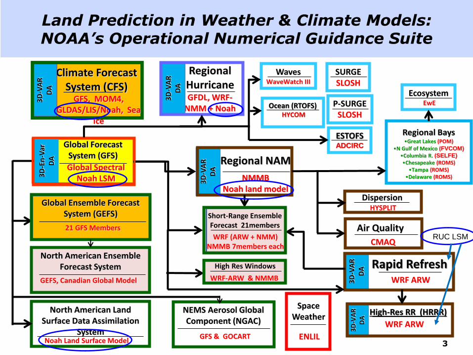
Land Prediction in Weather & Climate Models: NOAA’s Operational Numerical Guidance Suite
Regional Hurricane GFDL, WRF-
NMM + Noah
Climate Forecast System (CFS)
North American Ensemble Forecast System
GEFS, Canadian Global Model
Dispersion HYSPLIT
Air Quality
CMAQ
Regional NAM
NMMB Noah land model
3D
-VA
R
DA
Regional Bays •Great Lakes (POM)
•N Gulf of Mexico (FVCOM) •Columbia R. (SELFE) •Chesapeake (ROMS)
•Tampa (ROMS) •Delaware (ROMS)
Space Weather
ENLIL
North American Land Surface Data Assimilation
System Noah Land Surface Model
Global Spectral Noah LSM 3
D-E
n-V
ar
DA
Global Forecast System (GFS)
3D
-VA
R
DA
3D
-VA
R
DA
Rapid Refresh
3D
-VA
R
DA
Waves WaveWatch III
Ocean (RTOFS) HYCOM
Ecosystem EwE
Global Ensemble Forecast System (GEFS)
21 GFS Members
ESTOFS ADCIRC
SURGE SLOSH
P-SURGE SLOSH
WRF ARW
3D
-VA
R
DA
High-Res RR (HRRR)
NEMS Aerosol Global Component (NGAC)
GFS & GOCART
GFS, MOM4, GLDAS/LIS/Noah, Sea
Ice
WRF (ARW + NMM) NMMB 7members each
Short-Range Ensemble Forecast 21members
WRF-ARW & NMMB
High Res Windows
WRF ARW
RUC LSM
3

ENVIRONMENTAL MODELING CENTER
Land Prediction in NCEP Modeling Systems NGGPS meeting, NCWCP, 10 February 2016
seasonal storage
• Land Surface Models (LSMs) provide surface flux boundary conditions for heat, moisture and momentum to the atmosphere for NCEP weather and seasonal climate models.
Role of Land-Surface Models & Requirements
• Land models close surface energy and water budgets.
Land data sets, e.g. land use/land cover (vegetation type), soil type, surface albedo, snow cover, surface roughness, etc.
Atmospheric forcing to drive LSM.
Land Data Assimilation Systems (LDAS): provide initial land states for NCEP modeling systems.
Initial land states: Compared to atmosphere, land states carry more memory (especially deep soil moisture), similar to the role of SSTs and ocean temeratures.
Land Data Assimilation: some of these quantities may be assimilated, e.g. snow depth and cover, soil moisture.
• Land Model Requirements:
Physics: appropriate to represent land-surface processes (for relevant time/spatial scales) and assoc. LSM model parameters.
4

ENVIRONMENTAL MODELING CENTER
Land Prediction in NCEP Modeling Systems NGGPS meeting, NCWCP, 10 February 2016
Land Model Physics: Flux Boundary Conditions
soil
canopy
canopy water
Transpiration Canopy Water Evaporation
Latent heat flux (Evapotranspiration)
Direct Soil Evaporation
from soil surface/canopy
Sensible heat flux
to canopy/soil surface
Soil heat flux
i.e. surface roughness & near-surface turbulence (H), plant & soil processes (LE), and heat transport thru soil/canopy (G), affecting evolving boundary-layer, clouds/convection, and precipitation.
•Surface fluxes balanced by net radiation (Rn), = sum of incoming and outgoing solar and terrestrial radiation, with vegetation important for energy partition between H, LE, G,
Emitted longwave
snow
Snowpack & frozen soil physics
5

ENVIRONMENTAL MODELING CENTER
Land Prediction in NCEP Modeling Systems NGGPS meeting, NCWCP, 10 February 2016
Max.-Snow Albedo (1-deg, Robinson)
Snow-Free Albedo (seasonal, 1-deg, Matthews)
Green Vegetation Fraction (GVF) (monthly, 1/8-deg, NESDIS/AVHRR)
July Jan summer winter
• Climatologies: fixed/annual, monthly, weekly.
• Near real-time observations, e.g. GVF “becoming” a land state.
Soil Type (1-km, STATSGO-FAO)
Vegetation Type (1-km, IGBP-MODIS)
Land Data Sets Used in NCEP Modeling Systems
6

ENVIRONMENTAL MODELING CENTER
Land Prediction in NCEP Modeling Systems NGGPS meeting, NCWCP, 10 February 2016
• Climatology vs. near real-time GVF.
NGGPS Project: Incorporate near-realtime Green Vegetation Fraction (GVF), validation with LST
VIIRS AVHRR 5-year “Climatology”
• Ingest into NCEP models where near real-time GVF leads to better partition between surface heating & evaporation --> impacts surface energy budget, PBL evolution, clouds & convection.
• Initial summertime GFS tests in 2013, 2014, 2015 show improvements in low-level temperature and dew point, land-surface temperature.
• Part of a broader effort for land product data set ingest with focus on internal
consistency among various products (i.e. albedo, burned area, soil moisture, etc). Weizhong Zheng, Yihua Wu (NCEP/EMC), Bob Yu, Ivan Csiszar, Marco Vargas et al (NESDIS/STAR)
VIIRS GVF in US Midwest much lower than AVHRR
7

ENVIRONMENTAL MODELING CENTER
Land Prediction in NCEP Modeling Systems NGGPS meeting, NCWCP, 10 February 2016
NGGPS Project: Satellite-based Land Data Assimilation in NCEP Modeling Systems
• Use NASA Land Information System (LIS) to serve as a global Land
Data Assimilation System (LDAS) for testing both GLDAS, NLDAS.
• LIS EnKF-based Land Data Assimilation tool used to assimilate:
• Soil moisture from the NESDIS global Soil Moisture Operational Product
System (SMOPS).
• Snow cover area (SCA) from operational NESDIS Interactive
Multisensor Snow and Ice Mapping System (IMS), and AFWA snow
depth (SNODEP) products.
1. Build NCEP’s GFS/CFS-LDAS by incorporating the NASA Land Information System (LIS) into NCEP’s GFS/CFS (left figure)
2. Offline tests of the existing EnKF-based land data assimilation capabilities in LIS driven by the operational GFS/CFS.
3. Coupled land data assimilation tests and evaluation against the operational system.
NGGPS Project: Land Data Assimilation
Michael Ek, Jiarui Dong, Weizhong Zheng (NCEP/EMC)
Christa Peters-Lidard, Grey Nearing (NASA/GSFC)
Jiarui Dong, NCEP/EMC
NASA
(LIS)
8
ENVIRONMENTAL MODELING CENTER
Land Prediction in NCEP Modeling Systems NGGPS meeting, NCWCP, 10 February 2016
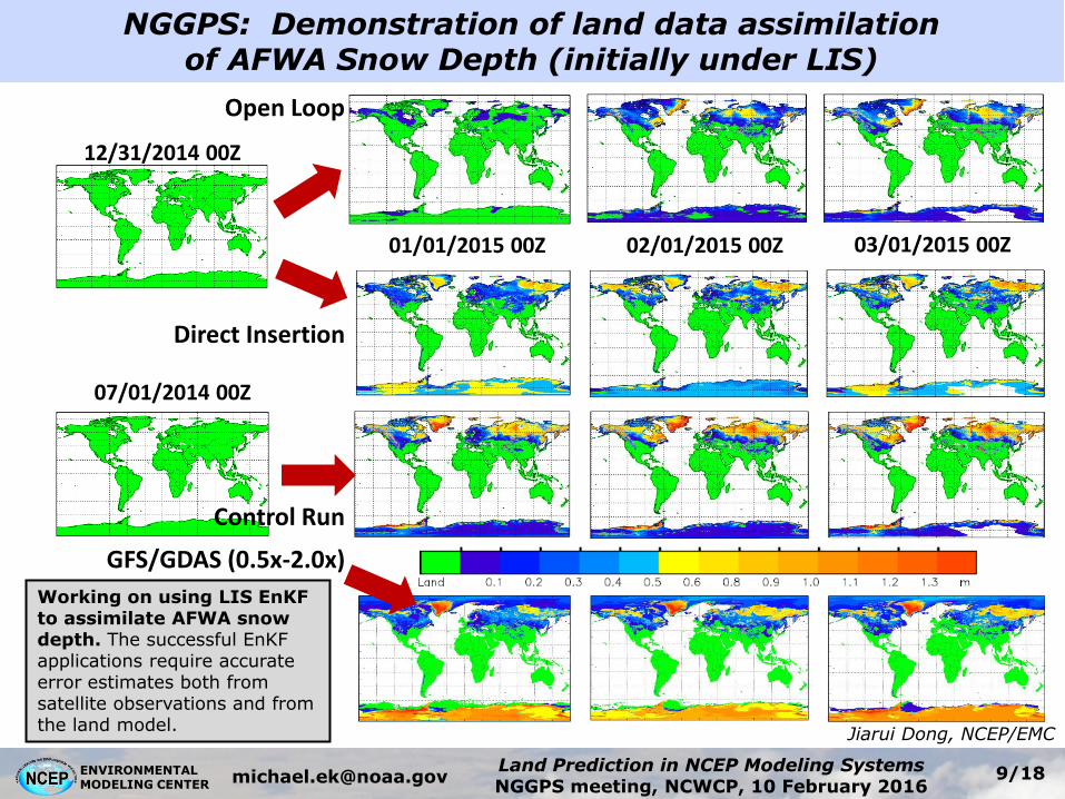
NGGPS: Demonstration of land data assimilation of AFWA Snow Depth (initially under LIS)
•
12/31/2014 00Z
01/01/2015 00Z 03/01/2015 00Z
Open Loop
02/01/2015 00Z
Control Run
07/01/2014 00Z
Direct Insertion
Working on using LIS EnKF to assimilate AFWA snow depth. The successful EnKF applications require accurate error estimates both from satellite observations and from the land model.
Jiarui Dong, NCEP/EMC
GFS/GDAS (0.5x-2.0x)
9
ENVIRONMENTAL MODELING CENTER
Land Prediction in NCEP Modeling Systems NGGPS meeting, NCWCP, 10 February 2016
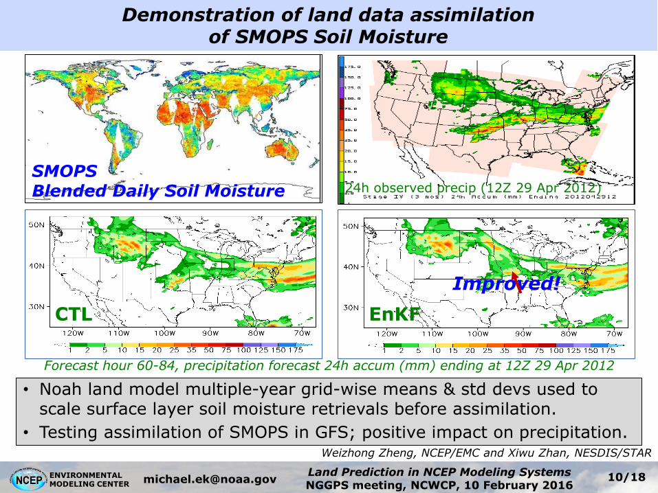
SMOPS Blended Daily Soil Moisture
• Noah land model multiple-year grid-wise means & std devs used to scale surface layer soil moisture retrievals before assimilation.
• Testing assimilation of SMOPS in GFS; positive impact on precipitation.
Forecast hour 60-84, precipitation forecast 24h accum (mm) ending at 12Z 29 Apr 2012
24h observed precip (12Z 29 Apr 2012)
EnKF CTL
Improved!
Weizhong Zheng, NCEP/EMC and Xiwu Zhan, NESDIS/STAR
Demonstration of land data assimilation of SMOPS Soil Moisture
10
ENVIRONMENTAL MODELING CENTER
Land Prediction in NCEP Modeling Systems NGGPS meeting, NCWCP, 10 February 2016
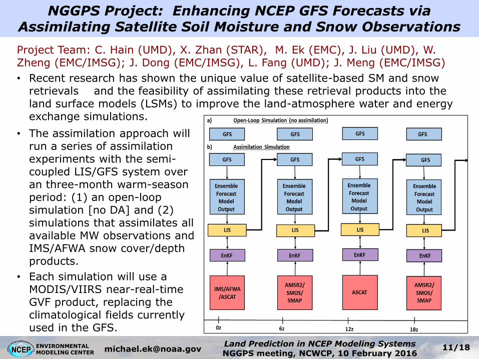
NGGPS Project: Enhancing NCEP GFS Forecasts via Assimilating Satellite Soil Moisture and Snow Observations
Project Team: C. Hain (UMD), X. Zhan (STAR), M. Ek (EMC), J. Liu (UMD), W. Zheng (EMC/IMSG); J. Dong (EMC/IMSG), L. Fang (UMD); J. Meng (EMC/IMSG)
• Recent research has shown the unique value of satellite-based SM and snow retrievals and the feasibility of assimilating these retrieval products into the land surface models (LSMs) to improve the land-atmosphere water and energy exchange simulations.
• The assimilation approach will run a series of assimilation experiments with the semi-coupled LIS/GFS system over an three-month warm-season period: (1) an open-loop simulation [no DA] and (2) simulations that assimilates all available MW observations and IMS/AFWA snow cover/depth products.
• Each simulation will use a MODIS/VIIRS near-real-time GVF product, replacing the climatological fields currently used in the GFS.
11

ENVIRONMENTAL MODELING CENTER
Land Prediction in NCEP Modeling Systems NGGPS meeting, NCWCP, 10 February 2016
• Noah surface model runs in semi-coupled mode with Climate Data Assimilation System version (CDASv2); daily update provides initial land states to operational Climate Forecast System version 2 (CFSv2).
• Forcing: CDASv2 atmospheric output, & “blended” precipitation, snow.
• Blended Precipitation: CPC satellite (heaviest weight in tropics); CPC gauge (heaviest mid-latitudes); model CDASv2 (high latitude).
• Snow: IMS cover & AFWA depth, cycled if within 0.5-2.0x “envelope”.
• 30+ year global land-surface climatology.
• Research/partners supported by NOAA Climate Program Office.
AFWA depth IMS cover
Current Global Land Data Assimilation System (GLDAS) at NCEP Operational in CFSv2 at NCEP 01 April 2011
CMAP Surface gauge GDAS
Precipitation Snow
Jesse Meng, NCEP/EMC
12
ENVIRONMENTAL MODELING CENTER
Land Prediction in NCEP Modeling Systems NGGPS meeting, NCWCP, 10 February 2016
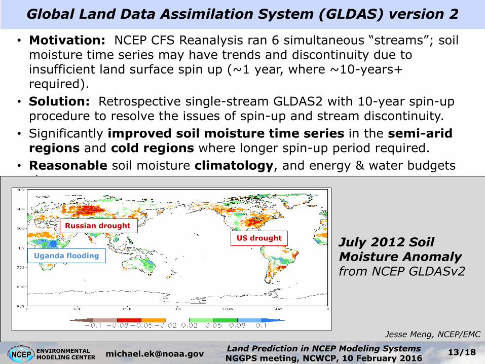
• Motivation: NCEP CFS Reanalysis ran 6 simultaneous “streams”; soil moisture time series may have trends and discontinuity due to insufficient land surface spin up (~1 year, where ~10-years+ required).
• Solution: Retrospective single-stream GLDAS2 with 10-year spin-up procedure to resolve the issues of spin-up and stream discontinuity.
• Significantly improved soil moisture time series in the semi-arid regions and cold regions where longer spin-up period required.
• Reasonable soil moisture climatology, and energy & water budgets closure.
Global Land Data Assimilation System (GLDAS) version 2
July 2012 Soil Moisture Anomaly from NCEP GLDASv2
Uganda flooding
US drought
Russian drought
Jesse Meng, NCEP/EMC
13
ENVIRONMENTAL MODELING CENTER
Land Prediction in NCEP Modeling Systems NGGPS meeting, NCWCP, 10 February 2016
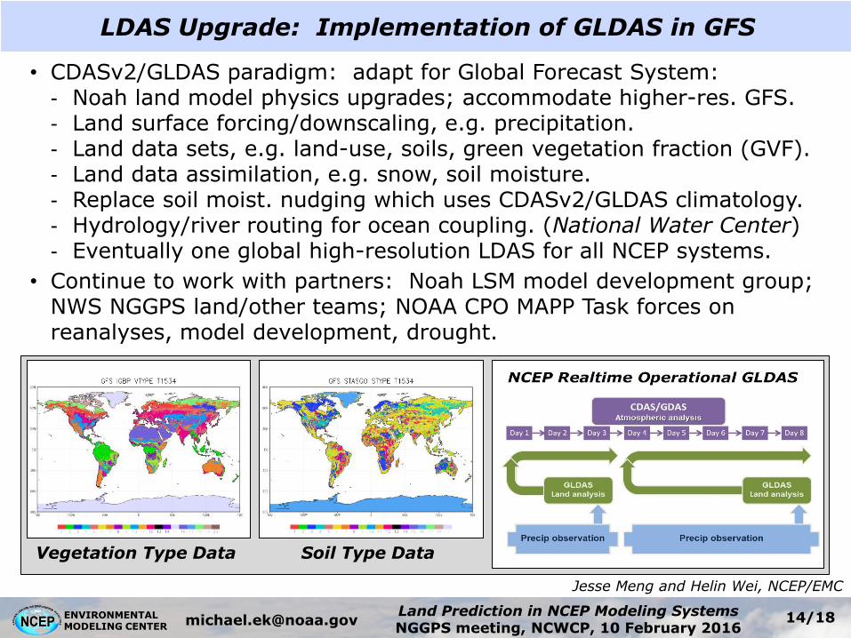
LDAS Upgrade: Implementation of GLDAS in GFS
• CDASv2/GLDAS paradigm: adapt for Global Forecast System: - Noah land model physics upgrades; accommodate higher-res. GFS. - Land surface forcing/downscaling, e.g. precipitation. - Land data sets, e.g. land-use, soils, green vegetation fraction (GVF). - Land data assimilation, e.g. snow, soil moisture. - Replace soil moist. nudging which uses CDASv2/GLDAS climatology. - Hydrology/river routing for ocean coupling. (National Water Center) - Eventually one global high-resolution LDAS for all NCEP systems.
• Continue to work with partners: Noah LSM model development group; NWS NGGPS land/other teams; NOAA CPO MAPP Task forces on reanalyses, model development, drought.
Jesse Meng and Helin Wei, NCEP/EMC
Vegetation Type Data Soil Type Data
14
ENVIRONMENTAL MODELING CENTER
Land Prediction in NCEP Modeling Systems NGGPS meeting, NCWCP, 10 February 2016
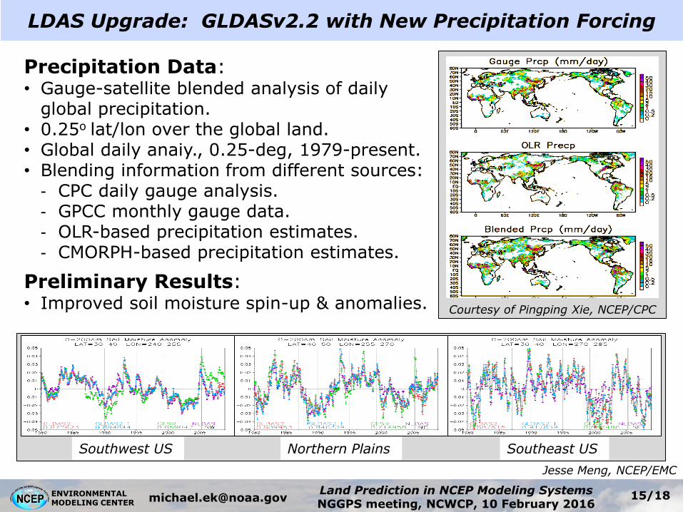
Precipitation Data: • Gauge-satellite blended analysis of daily
global precipitation. • 0.25o lat/lon over the global land. • Global daily anaiy., 0.25-deg, 1979-present. • Blending information from different sources:
- CPC daily gauge analysis. - GPCC monthly gauge data. - OLR-based precipitation estimates. - CMORPH-based precipitation estimates.
Preliminary Results: • Improved soil moisture spin-up & anomalies. Courtesy of Pingping Xie, NCEP/CPC
Southwest US Northern Plains Southeast US
LDAS Upgrade: GLDASv2.2 with New Precipitation Forcing
Jesse Meng, NCEP/EMC
15
ENVIRONMENTAL MODELING CENTER
Land Prediction in NCEP Modeling Systems NGGPS meeting, NCWCP, 10 February 2016
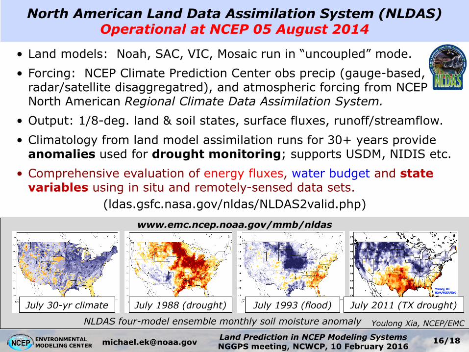
North American Land Data Assimilation System (NLDAS) Operational at NCEP 05 August 2014
NLDAS four-model ensemble monthly soil moisture anomaly
• Land models: Noah, SAC, VIC, Mosaic run in “uncoupled” mode.
• Forcing: NCEP Climate Prediction Center obs precip (gauge-based, radar/satellite disaggregatred), and atmospheric forcing from NCEP North American Regional Climate Data Assimilation System.
• Output: 1/8-deg. land & soil states, surface fluxes, runoff/streamflow.
• Climatology from land model assimilation runs for 30+ years provide anomalies used for drought monitoring; supports USDM, NIDIS etc.
• Comprehensive evaluation of energy fluxes, water budget and state variables using in situ and remotely-sensed data sets.
(ldas.gsfc.nasa.gov/nldas/NLDAS2valid.php)
July 30-yr climate July 1988 (drought) July 1993 (flood) July 2011 (TX drought)
www.emc.ncep.noaa.gov/mmb/nldas
Youlong Xia, NCEP/EMC
16
ENVIRONMENTAL MODELING CENTER
Land Prediction in NCEP Modeling Systems NGGPS meeting, NCWCP, 10 February 2016
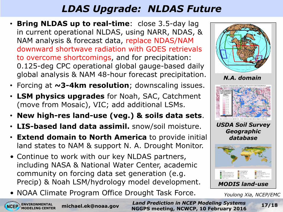
• Bring NLDAS up to real-time: close 3.5-day lag in current operational NLDAS, using NARR, NDAS, & NAM analysis & forecast data, replace NDAS/NAM downward shortwave radiation with GOES retrievals to overcome shortcomings, and for precipitation: 0.125-deg CPC operational global gauge-based daily global analysis & NAM 48-hour forecast precipitation.
• Forcing at ~3-4km resolution; downscaling issues.
• LSM physics upgrades for Noah, SAC, Catchment (move from Mosaic), VIC; add additional LSMs.
• New high-res land-use (veg.) & soils data sets.
• LIS-based land data assimil. snow/soil moisture.
• Extend domain to North America to provide initial land states to NAM & support N. A. Drought Monitor.
• Continue to work with our key NLDAS partners, including NASA & National Water Center, academic community on forcing data set generation (e.g. Precip) & Noah LSM/hydrology model development.
• NOAA Climate Program Office Drought Task Force.
USDA Soil Survey Geographic database
N.A. domain
MODIS land-use
LDAS Upgrade: NLDAS Future
Youlong Xia, NCEP/EMC
17

ENVIRONMENTAL MODELING CENTER
Land Prediction in NCEP Modeling Systems NGGPS meeting, NCWCP, 10 February 2016
LDAS Upgrade: Finer-Resolution Forcing Input for NLDAS
Downscaling and merging of precipitation (CPC OLR-based latest product)
Snapshots of precipitation
events in 2013. Stage IV and
NLDAS precipitation are
compared against OLR precipitation.
Re-run of URMA retrospective analysis producing 2.5-km 30 years historical
mesoscale reanalysis for CONUS and Alaska.
Comparison of UnRestricted Mesoscale Analysis (URMA) and NLDAS forcing
LDAS
Dail
y
OLR Stage IV
Ho
urly
Roshan Shretha, NCEP/EMC
18

ENVIRONMENTAL MODELING CENTER
Land Prediction in NCEP Modeling Systems NGGPS meeting, NCWCP, 10 February 2016
Model Physics Improvement: Noah-MP
Noah-MP is an extended version of the Noah LSM with enhanced multi-physics options to address shortcomings in Noah. • Canopy radiative transfer with shading
geometry. • Separate vegetation canopy. • Dynamic vegetation. • Ball-Berry canopy resistance. • Multi-layer snowpack. • Snow albedo treatment. • New snow cover algorithm. • Snowpack liquid water retention. • New frozen soil scheme. • Interaction with groundwater/aquifer.
Noah-MP references: Niu et al., 2011, Yang et al., 2011. JGR
Main contributors: Zong-Liang Yang (UT-Austin); Guo-Yue-Niu (U. Arizona); Fei Chen, Mukul Tewari, Mike Barlage, Kevin Manning (NCAR); Mike Ek (NCEP); Dev Niyogi (Purdue U.); Xubin Zeng (U. Arizona)
19
ENVIRONMENTAL MODELING CENTER
Land Prediction in NCEP Modeling Systems NGGPS meeting, NCWCP, 10 February 2016
Yihua Wu, NCEP/EMC
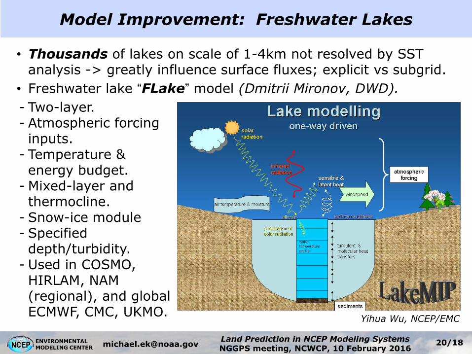
• Thousands of lakes on scale of 1-4km not resolved by SST analysis -> greatly influence surface fluxes; explicit vs subgrid.
• Freshwater lake “FLake” model (Dmitrii Mironov, DWD).
- Two-layer. - Atmospheric forcing inputs.
- Temperature & energy budget.
- Mixed-layer and thermocline.
- Snow-ice module - Specified depth/turbidity.
- Used in COSMO, HIRLAM, NAM (regional), and global ECMWF, CMC, UKMO.
Model Improvement: Freshwater Lakes
20
ENVIRONMENTAL MODELING CENTER
Land Prediction in NCEP Modeling Systems NGGPS meeting, NCWCP, 10 February 2016
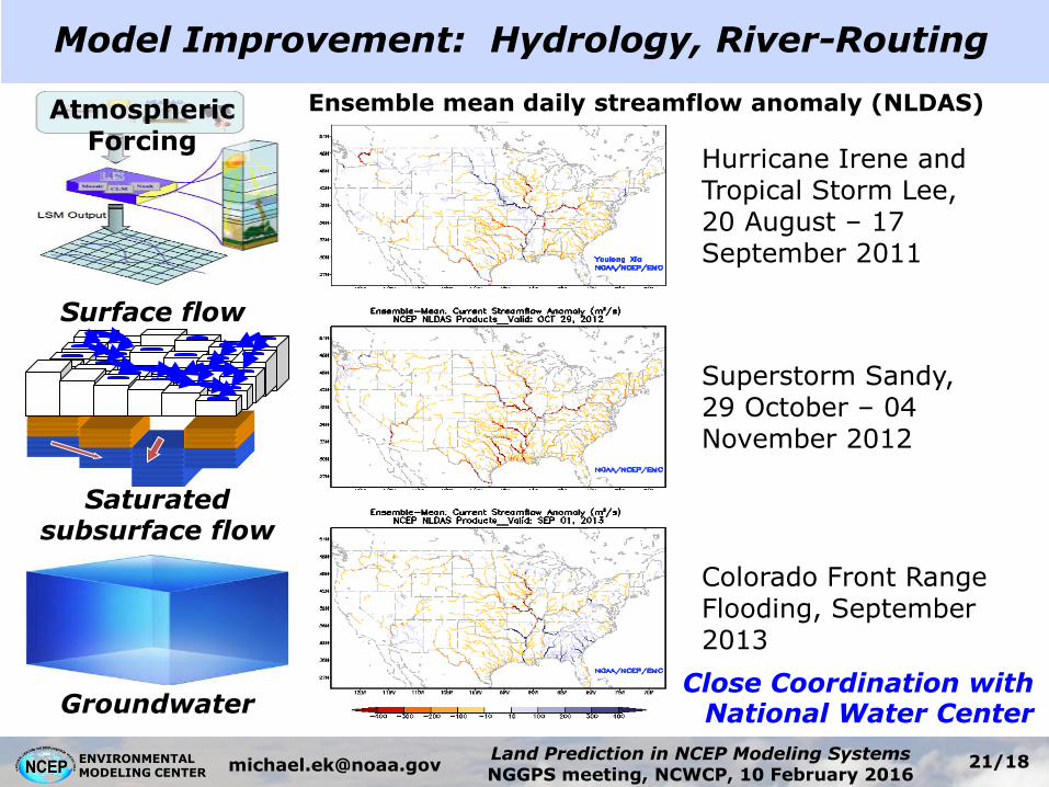
Atmospheric Forcing
Ensemble mean daily streamflow anomaly (NLDAS)
Hurricane Irene and Tropical Storm Lee, 20 August – 17 September 2011
Superstorm Sandy, 29 October – 04 November 2012
Colorado Front Range Flooding, September 2013
Groundwater
Surface flow
Saturated subsurface flow
Close Coordination with National Water Center
Model Improvement: Hydrology, River-Routing
21
ENVIRONMENTAL MODELING CENTER
Land Prediction in NCEP Modeling Systems NGGPS meeting, NCWCP, 10 February 2016
Ocean, Waves
Microphysics
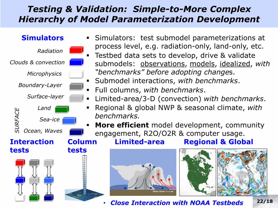
Testing & Validation: Simple-to-More Complex Hierarchy of Model Parameterization Development
Boundary-Layer
Radiation
Clouds & convection
Simulators Simulators: test submodel parameterizations at process level, e.g. radiation-only, land-only, etc.
Land
Sea-ice
Surface-layer
Testbed data sets to develop, drive & validate submodels: observations, models, idealized, with “benchmarks” before adopting changes.
More efficient model development, community engagement, R2O/O2R & computer usage. S
URFACE
Submodel interactions, with benchmarks.
Interaction tests
Limited-area/3-D (convection) with benchmarks.
Limited-area Column tests
Full columns, with benchmarks.
Regional & Global
Regional & global NWP & seasonal climate, with benchmarks.
22 • Close Interaction with NOAA Testbeds

ENVIRONMENTAL MODELING CENTER
Land Prediction in NCEP Modeling Systems NGGPS meeting, NCWCP, 10 February 2016
Testing and Validation: Surface-layer Simulator
• GOAL: Improve surface turbulence exchange coefficients. • Surface-layer simulation (“SLS”) code simulates surface-layer
and schemes from meso-NAM and medium-range GFS. • Use observations to drive SLS (U,T,q and Tsfc) and compare
with inferred Ch, Cd from independent “fluxnet” obs (H, LE, t). • Bias in surface exchange coefficient for heat dependent on
vegetation height. Action: adjust thermal roughness parameter.
Caterina Tassone, NCEP/EMC
short vegetation, czil=0.2 tall vegetation, czil=0.01
short vegetation, czil=0.1 tall vegetation, czil=0.1
default default
23

ENVIRONMENTAL MODELING CENTER
Land Prediction in NCEP Modeling Systems NGGPS meeting, NCWCP, 10 February 2016
• Validation uses near-surface observations, e.g. routine weather observations of air temperature, dew point and relative humidity, 10-meter wind, along with upper-air validation, precipitation scores, etc.
Testing and Validation: Land Model & Sfc-Layer
• To more fully validate land models at the process level, surface fluxes and soil states (soil moisture, etc) are also used.
• Monthly diurnal composites to assess systematic model biases (averaging out transient atmospheric conditions), and suggest land physics upgrades.
24
ENVIRONMENTAL MODELING CENTER
Land Prediction in NCEP Modeling Systems NGGPS meeting, NCWCP, 10 February 2016
E E
E
D
B
B
D G M G G C
W S
P
W
E E B D
E – Evergreen Needleleaf B – Evergreen Broadleaf D – Deciduous Broadleaf M – Mixed Forest G - Grassland C – Cropland W – Woody Savanna S – Savanna P – Permanent Wetlands
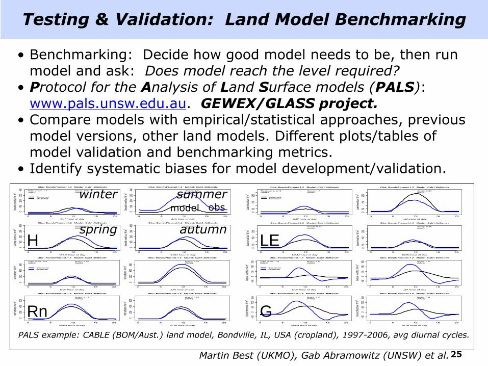
The PALS Land sUrface Model Benchmarking Evaluation pRoject (PLUMBER)
PALS example: CABLE (BOM/Aust.) land model, Bondville, IL, USA (cropland), 1997-2006, avg diurnal cycles.
LE
Rn G
H spring
summer
autumn
winter model obs
Testing & Validation: Land Model Benchmarking
• Benchmarking: Decide how good model needs to be, then run model and ask: Does model reach the level required?
• Protocol for the Analysis of Land Surface models (PALS): www.pals.unsw.edu.au. GEWEX/GLASS project.
• Compare models with empirical/statistical approaches, previous model versions, other land models. Different plots/tables of model validation and benchmarking metrics.
• Identify systematic biases for model development/validation.
Martin Best (UKMO), Gab Abramowitz (UNSW) et al. 25

ENVIRONMENTAL MODELING CENTER
Land Prediction in NCEP Modeling Systems NGGPS meeting, NCWCP, 10 February 2016
Testing & Validation: (uncoupled) NLDAS
Monthly streamflow anomaly correlation (1979-2007 USGS measured streamflow)
Ensemble Mean
Comprehensive evaluation against in situ observations and/or remotely sensed data sets.
Energy flux validation from tower: net radiation, sensible, latent & ground heat fluxes.
Water budget: evaporation, total runoff/streamflow.
State variables: soil moist., soil/skin temp., snow depth/cover.
Daily top 1m soil moisture anomaly corr. (2002-2009 US SCAN Network)
Xia et al., JGR-atmosphere (2012) Xia et al., J. Hydrol. (2014)
RMSE<0.06 m3/m3
26
ENVIRONMENTAL MODELING CENTER
Land Prediction in NCEP Modeling Systems NGGPS meeting, NCWCP, 10 February 2016
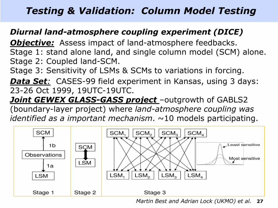
Testing & Validation: Column Model Testing
Diurnal land-atmosphere coupling experiment (DICE)
Objective: Assess impact of land-atmosphere feedbacks. Stage 1: stand alone land, and single column model (SCM) alone. Stage 2: Coupled land-SCM. Stage 3: Sensitivity of LSMs & SCMs to variations in forcing.
Data Set: CASES-99 field experiment in Kansas, using 3 days: 23-26 Oct 1999, 19UTC-19UTC. Joint GEWEX GLASS-GASS project –outgrowth of GABLS2 (boundary-layer project) where land-atmosphere coupling was identified as a important mechanism. ~10 models participating.
Martin Best and Adrian Lock (UKMO) et al. 27

ENVIRONMENTAL MODELING CENTER
Land Prediction in NCEP Modeling Systems NGGPS meeting, NCWCP, 10 February 2016
Testing and Validation: Fully Coupled GFS
• Forecast only
• Cycled
• Full parallel
• Metrics: precip, 500mb AC, upper air, surface temp/wind, etc
• Examples
28
Helin Wei, NCEP/EMC Results from the new LSC dataset tests on the GFS
ENVIRONMENTAL MODELING CENTER
Land Prediction in NCEP Modeling Systems NGGPS meeting, NCWCP, 10 February 2016
Improve & unify Noah land model and GLDAS/NLDAS at NCEP: – Forcing, e.g. precipitation, & land data sets, e.g. near-realtime GVF. – Run GLDAS, NLDAS under NASA Land Information System (LIS):
parallel run environment, latest land model versions, land data sets, data assimilation/validation tools for e.g. snow, soil moisture.
– Land model physics improvements, including next-generation “Noah-MP” with dynamic vegetation, etc; account for agriculture, irrigation, etc; lakes; hydrology/groundwater/river-routing.
– Higher resolution and downscaled forcing and model output. – Enhance land model spin-up procedures. – Extend domain/resolution of NLDAS to North America, to then
“merge” with GLDAS for global models (GFS, CFS), providing unified initial land conditions for all NCEP regional, global and climate models.
– Comprehensive hierarchy of model development and evaluation.
• Land models role expanding for weather & climate in increasingly more fully-coupled Earth-System Models (atmosphere-ocean-land-ice-waves-aerosols) with connections between Weather & Climate and Hydrology, Ecosystems & Biogeochemical cycles (e.g. carbon), and Air Quality, models and communities, i.e. under community model development, e.g. NOAA Environ. Modeling System (NEMS).
Land Prediction at NCEP: Summary/Future
29