land south of the bungalow, poslingford psg...
TRANSCRIPT

Land South of the Bungalow, Poslingford PSG 020
Archaeological Excavation Report v0.3
SCCAS Report No. 2014/066
Client: Row Build
Author: Rob Brooks
November/2014
© Suffolk County Council Archaeological Service


Land South of the Bungalow, Poslingford
Archaeological Excavation Report v0.3
SCCAS Report No. 2014/066
Author: Rob Brooks
Contributions By: Richenda Goffin and Val Fryer
Illustrators: Simon Cass and Beata Wieczorek-Oleksy
Editor: Richenda Goffin
Report Date: November/2014


HER Information
Site Code: PSG 020 Site Name: Land South of the Bungalow Report Number 2014/066 Planning Application No: SE/13/0769/FUL Date of Fieldwork: 2nd – 5th March, 2014 Grid Reference: TL 7699 4826 Oasis Reference: suffolkc1-178184 Curatorial Officer: Matthew Brudenell Project Officer: Rob Brooks Client/Funding Body: Row Build Client Reference: N/A Digital report submitted to Archaeological Data Service:
http://ads.ahds.ac.uk/catalogue/library/greylit
Disclaimer
Any opinions expressed in this report about the need for further archaeological work are those of the Field
Projects Team alone. Ultimately the need for further work will be determined by the Local Planning
Authority and its Archaeological Advisors when a planning application is registered. Suffolk County
Council’s archaeological contracting services cannot accept responsibility for inconvenience caused to
the clients should the Planning Authority take a different view to that expressed in the report.
Prepared By: Rob Brooks
Date: 26/11/2014
Approved By: David Gill
Position: Senior Project Officer
Date: 26/11/2014
Signed:


Contents
Summary
Drawing Conventions
1. Introduction 1
2. The Excavation 3
2.1 Site location 3
2.2 Geology and topography 3
2.3 Archaeological and historical background 4
3. Methodology 8
4. Results 10
4.1 Introduction 10
4.2 Larger pits 10
Pit 0006/0018 10
Pits 0011, 0022 and 0025 11
4.3 Smaller pits and posthole 14
Posthole 0008 14
Pit/depression 0028 14
Pit 0030 14
Pit 0037 14
Pit 0041 15
4.4 Ditch 15
Cuts 0032 and 0039 15
5. The finds evidence 18
5.1 Introduction 18
5.2 Pottery 18

Introduction and recording method 18
The pottery 19
Discussion 21
5.3 Ceramic building material and fired clay 24
5.4 Post-medieval bottle glass 24
5.5 Iron nails 24
5.6 The small finds 24
6. The environmental evidence 25
6.1 Faunal remains 25
6.2 Shell 25
6.3 Plant macrofossils and other remains 25
Introduction and method statement 25
Results 26
Conclusions and recommendations for further work 27
7. Discussion of the finds and environmental evidence 28
8. Overall discussion 29
9. Conclusions 31
10. Archive deposition 32
11. Acknowledgements 32
12. Bibliography 33
List of Figures
Figure 1. Location plan, showing site and HER entries 2 Figure 2. 1885 Ordnance Survey map of Poslingford 7 Figure 3. Site plan 9 Figure 4. Excavation plan 13 Figure 5. Sections 17 Figure 6. Pottery illustrations 23
List of Tables
Table 1. Finds quantities 18
List of Plates
Plate 1. View from the site to the church, showing The Street 4 Plate 2. 1841 Tithe map of Poslingford 6 Plate 3. Pit 0006/0018 11 Plate 4. Pits 0011, 0022 and 0025 12 Plate 5. Ditch 0032 16
List of Appendices
Appendix 1. Abridged written scheme of investigation Appendix 2. Context list Appendix 3. OASIS form
Appendix 4. Bulk finds catalogue Appendix 5. Pottery catalogue Appendix 6. Plant macrofossils and other remains


Summary
An excavation was carried out prior to the construction of housing and related services
and driveways on land to the south of a bungalow and immediately east of The Street in
Poslingford, Suffolk. This revealed pits, postholes and a ditch of 12th-13th century date,
which produced medieval pottery, roof tile, animal bone, fired clay, iron nails and a
shears blade. There were also environmental residues indicating hearth/midden waste,
burnt flooring/bedding and sewage or animal ordure. The features were well preserved
below imported and buried topsoil deposits and are probably contemporary with the
construction of the church, located just to the south-west.

Plans
S.14
Limit of Excavation
Features
Break of Slope
Features - Conjectured
Natural Features
Sondages/Machine Strip
Intrusion/Truncation
Illustrated Section
Limit of Excavation
Cut
Cut - Conjectured
Deposit Horizon
Deposit Horizon - Conjectured
Intrusion/Truncation
Top Surface
Top of Natural
Break in Section
Sections
18.45m OD
0007
0008
0008
Cut Number
Cut Number
Deposit Number
Ordnance Datum
Archaeological Features
Modern Cut
Drawing Conventions

1
1. Introduction
An archaeological excavation was carried out prior to the construction of two houses on
land to the south of an existing bungalow in Poslingford, Suffolk (Fig. 1). The site was
investigated due to its position within a medieval village, which has some evidence for
9th century activity, suggesting the presence of nearby burials. Both the evaluation and
excavation phases were carried out to look for the presence of any such remains and
provide more information on this otherwise unexcavated settlement.
The work was carried out to a Written Scheme of Investigation by John Craven (Suffolk
County Council Archaeological Service Field Team – Appendix 1) to fulfil a Brief by Dr
Matthew Brudenell (SCCAS Conservation Team) as a condition of planning application
SE/13/0769/FUL. Row Build Ltd funded the work that was carried out on the 2nd-5th
June, 2014.

Haven FarmNew House Farm
Tudor Lodge
Spindlewood
Cimla Cottage
CottageHall
13
18
19
7
20
The OldVicarage
Bryony Cottage
New House Cottage
Heatherbank
Briar Cottage
Saffron Cottage
HighbanksChaumiere Geranium
Pink Cottage
Appletree CottageThe
Cot
tage
Marigold Cottage
Hill
Cot
tage
sH
ill C
otta
ge
PO
Hall Cotta
ges
4
6
BungalowThe
Plough Cottageand DogShepherdThe Old
Function Room
DuwThe Former
Gras
CottageConifer
InSeldom
LodgeDerwent
HallPoslingford
ChurchSt Mary's
CottageChurch
1
Brookside
Honeysuckl
e Cottage
4
Bridge Cottage
Little
bourn
e
The Thatch
Pond
Pond
Pond
Pond
Pond
Pond
Pond
Issues
Pond
Pond
Pond
Drain
Drain
Pond
Pond
Pond
Drain
Pond
Issues
Pond
Drain
Drain
Issues
Track
Track
Trac
k
Path (um)
Track
Track
Track
Track
Track
Track
Trac
k
FBFB
FB
FB
FB
MemlWar
FB
FB
TCB
Pump
98.6m99.0m
100.0m
98.1m
94.1m
93.2m
82.1m
88.8m
66.8m
67.7m
72.0m
74.2m
78.3m
82.8m
86.5m
91.6m95.7m
72.3m
76.9m
67.7m
92.6m
97.3m
101.6m
69.3m
82.5m88.6m
93.1m
64.4m
64.8m
97.2m
83.7m
83.5m
83.5m
102.2m
104.9m
GardensAllotment
Cemetery
5765
00
247500
248000
248500
249000
576500
577000
577500
Clar
e Ro
ad
New House Lane
SITE
PoslingfordPoslingford
PSG 004
PSG 003PSG 003
Post-medievalfarm and millcomplex
Post-medievalfarm and millcomplex
PSG 006
TL
BBN
0 500m
B
0 10 km
A
Bury St. Edmunds
Cambridge
Chelmsford
Colchester
HarlowHertford
Ipswich
King's Lynn
Thetford
Norwich
Norfolk
Suffolk
Essex
Cambridgeshire
0 25 km
Bury St. Edmunds
Chelmsford
Colchester
Felixstowe
Ipswich
King's Lynn
Lowestoft
Norwich
Thetford
Norfolk
SUFFOLK
Essex
0 25 km
A
© Crown Copyright. All rights reserved. Suffolk County Council Licence No. 100023395 2014© Crown Copyright. All rights reserved. Suffolk County Council Licence No. 100023395 2014
Figure 1. Location plan, showing site (red) and HER entries (green)
2
3
2. The Excavation
2.1 Site location
The site was located near the street frontage within an area of former driveway and
garden, at grid reference TL 7699 4826. The village church is positioned 65m to the
south-west and the proposed development area (PDA) is just to the east of The Street,
which is the main road running through the village (Fig. 1).
2.2 Geology and topography
The recorded superficial geology of the area consists of Head clay, silt, sand and
gravel, with bedrock formations of Lewes Nodular, Newhaven and Culver chalk.
Immediately east and west of the site superficial deposits of Lowestoft formation
diamicton overlie bedrock formations of Lewes Nodular, Seaford, Newhaven and Culver
chalk (BGS, 2014). On site the geology presented itself as superficial deposits of
orange sand and gravel, orange sandy-stony-clay, yellowish-grey chalky clay, and
greyish-orange silty-clay, indicating a mixture of river terrace deposits, boulder clay and
diamicton.
The site slopes slightly from the north-east down to the south-west, with ground levels
of 69.72m above the OD recorded at the northern end of Trench 4 during the
evaluation, and 69.3m on the eastern edge of the excavation and 69.16m on the
western edge. Towards the stream on the western edge of the site (a tributary of the
Chilton Stream, which joins the Stour River) a height of 68.88m was recorded, with a
measurement of 68.35m on The Street, which is a sunken lane (Pl. 1). The gardens on
the opposite western side of the road are noticeably higher, with one spot height
recorded at 70.47m. However the properties to the north and south of the PDA were
consistently no higher than the site and this suggests that the ground levels on the
eastern side of The Street were never built up to the same extent as those on the west.
Therefore it is unlikely that the archaeological horizons were particularly truncated here,
although it is unclear as to why there was such a disparity between the eastern and
western sides of the lane.

4
Plate 1. View from the site to the church, showing The Street (facing south-west)
2.3 Archaeological and historical background
The site is of interest because it lies within the historical core of the medieval village of
Poslingford, within 60m of the medieval church, recorded in the Historic Environment
Record (HER) as PSG 003 (Fig.1). The village was noted in the Domesday listings as
containing fifty-four households (which was quite large) and also mentions the church,
which has been described by English Heritage as ‘mainly C13 and C14 … of random
flint with stone dressings, but with remains of C12 work’ (2014, list entry number
1265343). No direct archaeological intervention has occurred in the settlement core
before and as such evidence of its origins is limited. Of the archaeological records close
to the site, of particular interest is a 9th century gold ring, recorded 20m to the north of
the site (PSG 004). This represents ‘unusual early activity’ and potentially suggests the
presence of burials in the area (Brudenell, 2014).
A scatter of Roman pottery is also recorded 460m to the west of the development area
(PSG 006), with a post-medieval farm, dovecote, kiln and windmill complex located
c.600m to the east. The site is also located along the edge of a tributary that runs into

5
the Chilton Stream and this would have been quite a favourable setting for early
occupation, both in prehistory and later.
The 1841 Tithe map (Pl. 2) shows the site as an area enclosed by ditches and the
apportionment listings record it as ‘Pightle – Grass’ (Suffolk Record Office reference for
apportionments – T90A/1), indicating that it was a small field. Surrounding listings
include houses or cottages with gardens, and meadows. Immediately east of the site
apportionment 261 is recorded as ‘Chalk Hill’. Neither the first (1885) or second (1904)
editions of the Ordnance Survey (OS) map show any features on the site, which is
enclosed by ditches and the third edition of the OS map was not available. However the
1885 map does list the site to the north as The Smithy, although this is not mentioned
on later maps (Fig. 2). There is also a reference to a John London in 1761 who was a
blacksmith in Poslingford (Suffolk Record Office reference: FL501/7/15/2/ 60).
In March and April 2014 four evaluation trenches were excavated on the site. Two
medieval pits, two ditches and a posthole were excavated. These produced 11th-12th
and 12th-14th century pottery, animal bone, Oyster shell and a late medieval roof tile.
Environmental samples produced evidence of nearby agricultural and domestic activity
in the form of crop processing and/or usage, as well as hammerscale residue. The
features were well preserved below varying levels of overburden and were interpreted
as evidence characteristic of one or more medieval backyard plots running back from
the street frontage.

6
Plate 2. 1841 Tithe map of Poslingford (site shown as apportionment 262 – Suffolk Records Office reference T90A/2)

Fi
gure
2. 1
885
Ord
nanc
e S
urve
y m
ap o
f Pos
lingf
ord
(site
mar
ked
as 2
06)
7

8
3. Methodology
The site was excavated using a machine equipped with a toothless bucket, with the
work being constantly monitored and directed by an experienced archaeologist. Topsoil
and in places modern aggregate were removed, followed by some deposits of buried
topsoil and subsoil to expose any cut features and the natural geology. All of the upcast
spoil was monitored for finds and metal-detected. The excavation area was positioned
across the footprints of the proposed houses and measured up to 17.5m x 23m (Fig. 3).
When the site stripping was finished, soil profiles were cleaned and recorded in
conjunction with the digging and recording of the cut features. All of the pits and the
ditch were excavated, with a minimum of 50% sampled from all the pits and a >1m long
slot through the ditch. Environmental bulk samples were taken from all of the features
during the evaluation and excavation, with the exception of pits 0022, 0025 and 0041.
Colour digital photographs (at 300 x 300 dots per inch resolution with dimensions of
4288 x 2848 pixels) were taken of the contexts and the site. A 1:50 plan of the
excavation was hand drawn and geo-referenced using an RTK GPS. Sections were
drawn at 1:20. A single continuous numbering system was used to record all contexts
(records 0017-0045) and these, combined with those from the evaluation are presented
in Appendix 2. A visit was made to the Bury St Edmunds branch of the Suffolk Record
Office to obtain the Tithe map and look for other relevant documents.
Site data has been input onto an MS Access database and recorded using the County
HER code PSG 020. An OASIS form has been completed for the project (reference no.
suffolkc1-178184 – Appendix 3) and a digital copy of the report submitted for inclusion
on the Archaeology Data Service database (http://ads.ahds.ac.uk/catalogue/library/
greylit). The archive is kept in the main store of Suffolk County Council Archaeological
Service at Bury St Edmunds under HER code PSG 020.

0011
0006
0008
0004
0013
S.4
S.2
S.3
S.1
S.5
Tr.4
Tr.3
Feat
ures
Mod
ern
© C
row
n C
opyr
ight
. A
ll rig
hts r
eser
ved.
Suf
folk
Cou
nty
Cou
ncil
Lice
nce
No.
100
0233
95 2
014
020
m
Sect
ion
Scal
e 1:
400
N
9
F
igur
e 3.
Site
pla
n (a
lso
show
ing
eval
uatio
n Tr
ench
es 3
and
4)
10
4. Results
4.1 Introduction
Across the site ten features were excavated, comprising one ditch, one post-hole and
eight pits of varying size (Figs. 4 and 5). Overlying the features were a mixture of
deposits, measuring 0.25m-0.45m thick and made up generally of a layer of modern
and probably imported topsoil, over buried in-situ topsoil, leaving the archaeological
levels generally well preserved. Close to the bungalow a small area had also been
consolidated during the development using aggregate, though this had not truncated the
archaeological levels. Full context descriptions are given in Appendix 2.
Six of the features produced medieval pottery, the bulk of which falls broadly within a
12th-13th century range, although some slightly earlier and later wares and CBM were
also recovered (11th-15th century).
Three of the remaining four features did not produce datable material and do not have
stratigraphic relationships with other contexts on site. However these are assumed to be
part of the same phase of activity due to the absence of features or finds from other
periods and due to their broadly similar fills. One of these cuts also produced
hammerscale, as did two datable features on the site, which also suggests that it is part
of the medieval phase. The remaining feature that did not produce finds was part of a
series of three inter-cutting pits, of which the other two cuts produced 12th-15th century
pottery and CBM.
4.2 Larger pits
Four larger pit cuts were excavated on the site, which were interpreted out in the field as
possible quarry pits, partially back filled with domestic waste.
Pit 0006/0018
Pit 0006 was partially excavated in the evaluation, with an extended slot excavated as
cut 0018 in the excavation works (Pl. 3). In plan the cut was a slightly misshapen circle,
measuring 1.78m x 1.68m x 1.05m deep, while the profile had initially steep sides that
then became concave, undercutting the top of the pit, before gradually curving to the

11
almost flat base. Upper fill 0026 was recorded as dark brownish-grey silty-clay, with
small flints, charcoal flecks and chalk flecks, as well as thirteen sherds of mid 12th-mid
13th century pottery (103g) and animal bone. During the evaluation (when recorded as
fill 0005) the upper fill also produced 11th-12th and 12th-14th century pottery. The
environmental material (sample 2) from this fill contained remnants of cereal grains,
weeds, wetland plants, some charcoal, mollusc remains and tarry deposits. The basal
fill, 0027 was hard to differentiate from 0005/0026 and as such no finds were separately
collected from this context. The pit was cut into cut into orange stony-clayey-sand at the
top, while by the base it had reached a deposit of yellowish-grey chalky boulder clay.
Plate 3. Pit 0006/0018 (facing east, 2m scale)
Pits 0011, 0022 and 0025
A series of inter-cutting pits were recorded in both the evaluation and the excavation,
although during the evaluation it was not felt to be sufficiently clear as to whether one or
more cuts were present (Pl. 4). All three pits are interpreted as contemporary, but
stratigraphically the latest cut was 0011, containing fills 0024, 0044 and 0045. This cut
measured 1.62m x 1.9m x 0.6m deep and formed a circular/sub-square shape in plan,
with steep and slightly convex sides, that curved sharply to a slightly concave base.
Upper fill 0045 was recorded as mid to dark grey clayey-silt with frequent flints and two
sherds of late 12th-14th century pottery (10g). It overlaid 0044, which consisted of light
yellowish-grey silty-clay, with flints and gravel and one fragment of 13th-15th century

12
CBM, as well as thirteen fragments of animal bone. The basal fill, 0024, was very similar
to 0044, but with a higher proportion of small stones and no finds. Sample 4, recovered
from fill 0009 in the evaluation (reinterpreted as fills 0024, 0044 and 0045 in the
excavation) contained remnants of cereals (low levels), dry and wetland plants, trees,
charcoal, black tarry deposits, bone, coal and mollusc remains.
Pit 0025 was cut by 0011, but subsequently cut pit 0022. As with pit 0011, cut 0025 was
quite irregular in plan, forming a roughly east to west aligned oval that measured 2.23m
x >1.24m x 0.34m deep. In profile the cut had moderately sloped sides, curving to a flat
base and it was filled with 0019, 0020 and 0021. Upper fill 0021 was light to mid yellow-
grey clayey-silt with angular flints and two sherds of 12th-14th century pottery (11g) and
one iron nail. Underlying this was fill 0020, which was dark brownish-grey clayey-silt,
with angular flints, one sherd of 14th-15th century pottery (2g), one piece of CBM and
two oyster shells. The basal fill 0019 was yellowish-brown silty-clay and contained two
sherds of late 12th-14th century pottery (15g).
A small pit, 0022, was recorded on the southern end of cut 0025 and was possibly cut
by it. Its form in plan was hard to distinguish, but it measured >0.24m x >0.27m x 0.22m
deep and contained light to mid brownish-grey clayey-silt 0023, with flints and no finds.
It had moderate to near vertical slightly concave sides and a slightly irregular concave
base.
Plate 4. Pits 0011, 0022 and 0025 (2m scale, facing east)

995/250 000/250
995/255 000/255
Modern
Eval trench
Modern Pond
Black organic silt
Mid grey clay
Flooded
not bottomed
b b b b b
b
b
b
b
b
b
b
b
b
b
b
b
b
b
b b b
b b
c c
b
S.9S.12
S.7S.8
S.10
S.11
S.6
S.3
0032
00370039
0008
0041
0030
0011
0025
0022
0028
0006/0018
Modern Pond
Base notuncovereddue to flooding
Notbottomed
Naturalfeature
© Crown Copyright. All rights reserved. Suffolk County Council Licence No. 100023395 2014
N
Figure 4. Excavation plan
13
Plan Scale 1:150
0 10.00m

14
4.3 Smaller pits and posthole
Posthole 0008
Posthole 0008 was entirely excavated in the evaluation. This was a well-defined round
cut in plan, measuring 0.38m x 0.34m x 0.08m deep, with steep sides at c.75°, which
had a rapidly curving break of slope to the flat base. The posthole was filled with 0007,
which was dark greyish-brown loose silty-clay, with small-medium flints. No finds were
recovered from the posthole. Sample 3 contained low levels of cereals, dry land plants,
charcoal, coke-like and tarry material, coal fragments and mollusc remains.
Pit/depression 0028
Context 0028 was partially sub-rounded in plan with an irregular western edge and was
very shallow, measuring just 0.06m deep x 0.7m x 0.78m. Its sides had a very slight
slope, with a flat to slightly concave base. Fill 0029 was very dark grey/black silt with
occasional small flints and three 11th-12th century pottery sherds (14g), sixteen
fragments of animal bone and one oyster shell. Sample 6 produced the remains of
cereals, dry land plants, trees, charcoal, coke-like material, bone, faecal material, small
coal fragments, vitreous pieces and molluscs. This feature may have been a cut, or a
possibly natural depression.
Pit 0030
Although possibly a large posthole, feature 0030 was interpreted on site as the base of
a truncated pit, due to its somewhat irregular base and concave moderately sloping
sides. It was oval in plan, with dimensions of 0.73m x 0.62m x 0.16m deep and an
almost flat base that was shallower at the south-east end. Its single fill was recorded as
0031 and was dark brownish-grey silt with one animal bone. The sample produced low
levels of cereal remains, dry land plants and trees, charcoal, coke-like material, tarry
material, bone, small coal fragments and molluscs.
Pit 0037
Pit 0037 was recorded on the southern edge of ditch cut 0039, but no relationship was
visible between the two features. It had an irregular oval cut, aligned north to south, with

15
35°-80° concave to convex variable sides, curving to an uneven base. There were
patches of what appeared to be heated red sand around the cut in places, but there was
only occasional charcoal and fired clay in the fill. The pit was >1.15m x 0.75m x 0.28m
deep and the uneven edges of the outline may have indicated two separate features,
although it was interpreted that the form of the cut was more likely related to the uneven
sandy-gravel river terrace type deposits into which it was dug. Single fill 0036 was
recorded in the feature, which was grey clayey-silt, with small stones and occasional
chalk and charcoal flecks. Twenty-seven sherds of mid 12th-mid 13th century pottery,
weighing 206 grams were recovered from the fill, along with three pieces of fired clay,
three animal bone fragments and one oyster shell. The sample produced cereal
remains, dry and wetland plants, trees, charcoal, coke-like and tarry material,
mineralised faecal material, arthropod remains, bone, small coal fragments and
molluscs.
Pit 0041
Along the western edge of the site was a pit recorded as 0041. It only partially emerged
from the limit of excavation, but had a rounded edge in plan, with very steep sides and a
sharp break of slope at base to the stepped and slightly concave base. It measured
>0.84m x >0.18m x 0.38m deep and contained light to mid yellowish-grey gravelly-silt fill
0042. The sample produced cereal remains, dry land plants, charcoal, coke-like
material, bone, small coal fragments and molluscs.
4.4 Ditch
Cuts 0032 and 0039
At the northern end of the site a ditch (consisting of a cut and probable re-cut) ran east
to west before being truncated by a modern pond (Pl. 5). In the evaluation this feature
was over-machined as cut 0004 and misinterpreted as either a curvilinear ditch or a
series of shallow pits. In that instance it produced 12th-14th century pottery from single
fill 0003. Where fully excavated as cut 0032 in the excavation it was up to 3.52m wide x
0.56m deep with a steep concave southern edge and a shallow-moderately sloping
northern side, with a gently sloping and slightly concave base that dipped down slightly
near the southern edge. Three fills were recorded in cut 0032. Upper fill 0035 was mid-
dark brownish-grey gravelly-silt with a loose lens of small-medium flints near the base of

16
the fill, a lens of light yellowish-orange clayey-silt along the base of the fill at the
southern end and no finds. Underlying this was fill 0034, which contained twenty-eight
sherds of mid 11th-12th century pottery (329g) and described as very dark grey/black
silt with frequent charcoal and occasional flints. This material is the same as 0004 from
the evaluation where it was sampled, producing the highest levels of cereals from the
environmental assemblage, as well as dry and wetland plants, trees, charcoal, coke-like
and tarry material, burnt/fired clay, bones and coal fragments, and molluscs. Basal fill
0033 was light to mid grey silty-clay, with occasional small flints and no finds. Although
it was not very distinct in plan or section, it is possible that fill 0033 in cut 0032 may
represented an original cut of the ditch, whilst fills 0034 and 0035 may be the infilling of
a re-cut. It is also likely that the ditch continued into the area of evaluation Trenches 3
and 4 as feature 0013 (Fig. 3). Environmental material from cut 0013 included cereals,
dry and wetland plants, charcoal, coke-like and tarry material, bones and mollusc
remains.
The ditch was also partially excavated as cut 0039 in order to look for a relationship with
pit 0037. Here a single fill of dark grey clayey-silt, with common stones and occasional
chalk and charcoal flecks was recorded as 0036, producing five sherds of mid 13th-14th
century pottery (24g), two pieces of fired clay, five animal bone fragments and a blade
from a pair of iron shears (SF 1001). No clear relationship was visible in plan or section
between the ditch and the pit.
Plate 5. Ditch 0032 (2m scale, facing north-west)

0023
0019
0020
0021
0024
0044
0045
0022
0025
0011
NS
S.6
68.7
6m O
D
68.9
5m O
D
0027
0026
/000
5
0018
\00
06
NS
S.7
0036
0038
0039
0037
NS
S.11
68.7
m O
D
68.9
5m O
D
0029
0028
NS
S.8
68.6
9m O
D
0031
0030
NW
SES.
968
.83m
OD
68.8
3m O
DTo
psoi
l
Mod
ern
0033
0035
0034
0032
SN
S.10
Tops
oil
Bur
ied
Tops
oil
Subs
oil
0042
Subs
oil
0041
SN
S.12
17
Figu
re 5
. Sec
tions

18
5. The finds evidence
Richenda Goffin
5.1 Introduction
Table 1 shows the quantities of bulk finds by context from the excavation. The table
includes additional finds recovered from samples. A full catalogue is shown in Appendix
4.
Context Pottery CBM F clay Animal bone Miscellaneous Spotdate
No. Wt/g No. Wt/g No. Wt/g No. Wt/g 0017 1 38 19th C glass
bottle Med/late pmed
0019 2 15 L12th-14th C 0020 1 2 1 52 2 oyster shell
13g 14th-15th C
0021 2 11 1 Fe nail 1g 12th-14th C 0026 13 103 6 33 Mid 12th-Mid
13th C 0029 3 14 16 38 Ferrous frags, 1
oyster 2g 11th-12th C
0031 1 2 Ferrous frags 0034 28 329 Mid 11th-12th
C 0036 27 206 3 2 3 212 Includes 40g
bone from sample 09, ferrous frags, 1 oyster 1g
Mid 12th-Mid 13th C
0038 5 24 2 30 5 141 SF1001 Iron shears fragment
M13th-14th C
0043 1 23 12th -14th C 0044 1 106 13 141 13th-15th C 0045 2 10 L12th-14th C Total 85 775 2 158 5 32 44 566
Table 1. Finds quantities
5.2 Pottery
Introduction and recording method
A total of sixty-four fragments of pottery weighing 686 grammes was recovered from the
excavation. The assemblage dates almost entirely to the medieval period, with most of
the pottery dating to the 12th-13th centuries.
The ceramics were fully quantified using the recording methods recommended in the
MPRG Occasional Paper No 2, Minimum standards for the processing, recording,

19
analysis and publication of Post-Roman ceramics (Slowikowski et al, 2001). The pottery
was sorted by fabric and where possible, by vessel. The number of sherds present in
each context by fabric, the estimated number of vessels represented and the weight of
each fabric was noted. Other characteristics such as form, decoration, condition and
fabric date range were recorded, and an overall date range for the pottery in each
context was established.
The pottery was catalogued by context using letter codes based on fabric and form and
this data has been recorded in an Access database and summarised in Appendix 5.
The codes used are based mainly on broad fabric and form types identified in Eighteen
centuries of pottery from Norwich (Jennings, 1981), with additional fabric types and date
ranges from the Suffolk Post-Roman Fabric Series (S Anderson, unpublished). Where
possible rim forms from the Essex type series were used (Drury, 1993). The catalogue
also includes the pottery from the evaluation.
The pottery recovered through the sampling process was scanned to see if there was
any additional dating evidence, especially for contexts where no datable finds had been
recovered through hand-retrieval.
The pottery
Medieval pottery was recovered from the fills of two fragments of ditches 0032 and
0038, and a number of pits, some of which had been identified during the evaluation.
The largest quantity of pottery was found in fill 0034 of ditch 0032. A total of twenty-
eight fragments weighing 329 grammes were present. The group consists of a variety of
medieval sandy wares of varying appearance, indicating a range of different production
sites. Several fragments of the sooted base of a hard sandy greyware jar can be
classified as Bury Medieval coarseware. Two joining sherds of a distinctive jar are likely
to be the products of an Essex kiln site, such as Mile End or Great Horkesley. They are
made in a hard fabric which has a reddish brown interior with dark grey margins. The
fabric has a fine matrix but contains sparse coarse quartz, together with occasional soft
red inclusions that are likely to be haematite. In this respect it is similar to Fabric C of
the pottery production site at Mile End (Drury and Petchey, 1975). The jar is nearly
straight-sided and has a pronounced external bead with internal bevel (diameter

20
180mm) (Fig. 6, No.1). It is unevenly made with prominent girth-grooving. The dating of
this form is difficult because it is unusual, but straight-sided jars from Colchester are
thought to date to late 12th-13th century (Cotter 44). It is accompanied by a second jar
which has also has an external beaded rim (Essex type C1), which is made in a sandy
fabric with shell dusting on the external surface (Fig. 6, No. 2). This fabric is the same
as the Essex Fabric 12C. This type of rim can be dated from the second half of the 11th
century through to the thirteenth century (Cotter, 50). The remainder of the pottery from
this feature is made of medium sandy wares, many of which have grey cores but have
pale or mid-brown external margins which are very similar to the Essex type early
medieval sandy wares (Essex Fabric 12). Some have shallow but widely spaced girth
grooves, and some have surface inclusions of shell. Three fragments are hand-made in
their appearance with poorly mixed fabrics containing large quartz inclusions as well as
some organic matter; they resemble Early medieval gritty wares dating to the 11th-12th
centuries.
Further fragments of medieval pot were present in fill 0038 of ditch 0039. The abraded
rim of a coarseware grey jar with a neckless rim dates to c.1250-1375. It is similar to rim
types from the Great Horkesley kiln (Drury and Petchey fig. 13, nos. 73-76), but a
fragment of an Essex type early medieval sandy ware cooking pot rim, which has
shallow thumbing on the top may belong to the 12th century.
Eight sherds of medieval pottery were recovered through hand collection from the fill
0036 of a pit located close to ditch 0038. Several sherds of a greyware vessel similar in
fabric to Bury coarseware were identified, together with a globular sandy sherd with a
worn surface and reddish-brown interior which is probably once again an Essex type
medieval ware. A large fragment of a Hedingham ware jug was present, which has a
pitted splashed external glaze and rilling on the neck. Although it is fragmentary, it may
belong to an early rounded jug of London-style which dates to c.1140/50-1200 (Walker
37). Further fragments which were present in the environmental sample taken from
0036 include small fragments of Early medieval wares (11th-12th century), other
medieval sandy wares and a large sherd of a cooking vessel or jar with an upright neck
with a thickened squared rim which is categorised as an Essex H1 form, which is most
frequently found in Essex groups dating to the 13th century (Drury 1993, fig. 40).

21
Pottery was recovered from three fills of pit 0025. The basal fill 0019 contained two
body sherds of medieval coarseware dating to the late 12th-14th centuries, whilst a
small sherd of Colchester ware was identified in the middle fill 0020 which has a wide
date range of the late 13th-16th century. Two further body coarseware sherds present in
the upper fill 0021 again date to the late 12th-14th century. The fill 0045 of adjacent pit
0011 also contained two joining sherds of sandy medieval ware dating to the 12th
century or later.
Further fragments of medieval pottery were collected from fill 0026, the upper deposit of
pit 0006/0018, which was found during the evaluation phase (0005). A number of
greyware sherds with silver mica were present, together with two more hand-made
sandy wares, one of which had an incised decoration on the outer surface. Fragments
of two Hedingham ware fineware vessels were identified (Mid 12th-Mid 13th C) – this
fabric was also found in the evaluation ceramics.
Discussion
The ceramics from the evaluation and the excavation are for the most part restricted in
their overall date range, which is mainly the 12th-13th centuries. A small quantity of
pottery may be slightly earlier, as two sherds of St Neots-type wares identified during
the evaluation in pit 0006 and 0009 date to the 11th-12th century. A number of sandy
medieval wares were present, including Colchester- type Early medieval sandy wares,
some of which are shell-dusted. Other types of medieval coarsewares with medium
sandy fabrics, sometimes with a grey core and reddish brown margins come from other
production sites, probably from kilns such as Mile End and Great Horkesley. In addition
harder, grey sandy medieval coarsewares were also present, and many of these are
very similar to the ‘Bury coarsewares’ found in the town of Bury St Edmunds. The rim of
a Bury ware jar with yellow/buff surfaces and sparse chalk inclusions with a thickened
rim dating to the 12th-13th century was for example, found in topsoil deposit 0017 (Fig.
5, No. 3). This fabric type, with its coarse inclusions, is now considered to have
originated in the area of the fens (Sue Anderson, pers. comm.). The only glazed wares
present are Hedingham wares, but these are mostly fragmentary, apart from the jug
sherd from the fill 0036 of pit 0037. There is no evidence of fully developed jar rims
which date to the 14th century or later in the excavation assemblage, apart from a
steep-sided flanged bowl from Trench 3 of the evaluation which is likely to date to the

22
13th-14th century. It is similar to published examples from Mile End and Great
Horkesley which are of this date (Drury, fig. 41, nos. 86, 87, 89 and 90).
Little work has been done in the village of Poslingford, and the ceramics reflect its
location to the south of Bury St Edmunds close to the border with Essex. The
Hedingham kiln sites lie c. 8 miles to the south of the site across the River Stour. The
production sites of Mile End and Great Horkesley are further to the south-east, closer to
Colchester. The village was also clearly using medieval coarsewares which are
commonly found on excavations within the town of Bury St Edmunds. The types of
pottery present are similar to the more wide-ranging group of medieval ceramics studied
from the site of ‘Land East of the Granary, Clare’ (CLA 079 – Anderson, 2013).

PSG 020 0034
(1)
(2)
(3)
PSG 020 0017
PSG 020 0034
0 5 10cm
Scale 1:2
Figure 6. Pottery illustrations (No. 1 - coarseware jar from fill 0034 of ditch 0032, No. 2 - Shell dusted ware from fill 0034 of ditch 0032, No. 3 - Bury coarseware)
23

24
5.3 Ceramic building material and fired clay
A small quantity of ceramic building material was recovered (2 fragments weighing
158g). A single fragment of a fully oxidised roofing tile was found in the fill 0020 of pit
0025 which has the remains of mortar on its two main surfaces. It is made in a fine
sandy fabric with sparse iron oxide, flint and calcareous inclusions, but its main
characteristic is that it has small chalk fragments on the moulded side. It dates to the
medieval or late medieval period. A second fragment of roof tile was the only find
recovered from the fill 0044 of pit 0011. It is made in a fine orange fabric with moderate
red grog inclusions, and has a reduced core, indicating that it also dates to the medieval
or late medieval period.
Small quantities of fired clay were also recovered from the fill 0038 of ditch 0039 (2
fragments weighing 30g). The largest piece is made of fine, poorly mixed clay which has
moderate large chalk inclusions up to 8mm in length. The fragment is probably medieval
and the fabric is typical of the type used during the medieval period to form oven domes
(Sue Anderson, pers. comm.). Another smaller harder fragment has sparse flint
inclusions and may represent a piece of fuel ash slag.
5.4 Post-medieval bottle glass
An almost complete pale blue glass medicine bottle was found in the topsoil layer 0017.
It has moulded subdivisions in the glass for tablespoon measurements and is likely to
date to the twentieth century.
5.5 Iron nails
A small fragment of iron, probably the shank of a nail with a thickening at the upper end,
was present in fill 0021 of pit 0025, which also contained medieval pottery.
5.6 The small finds
A single small find was recovered from the site. Part of the iron blade of a shears arm
was present in fill 0038 of ditch 0039. Although missing the tip and the bow element of
the shears, enough survives of the length of the sloping blade (141mm) to suggest that

25
the shears were used for sheep shearing or cloth cutting (Margeson, 1993, 133). Such
shears were used in the medieval period (Cowgill et al, 1987).
6. The environmental evidence
6.1 Faunal remains
Twenty-nine fragments of animal bone (500g) were hand collected from five contexts
from the excavation, with some additional small bone pieces present amongst the
sampled material. Nearly all of the assemblage was recovered from the fills of mainly
medieval pits, with one group from the fill 0038 of the ditch 0039. The majority of the
bone is very fragmentary but some diagnostic pieces were present.
Small quantities of fragmentary bone present in fill 0044 of pit 0011 consist of the
mandible of a cow, the scapula of a sheep and the shaft of a mammalian humerus
which has no distal or proximal ends. Fill 0036 of pit 0037 contained part of the humerus
of a pig, the tibia of a bird and a large rib fragment from a cow or horse. Part of the skull
of a rabbit was identified in fill 0029 of pit 0028.
Stained and blackened fragments from the fill 0038 of ditch 0039 include a bovine horn
core and the remains of other bone shafts, some of which have been cut longitudinally.
6.2 Shell
Small quantities of oyster shell were collected from fill 0020 of pit 0025 and fill 0036 of
pit 0037 (3 fragments weighing 24g). These were subsequently discarded.
6.3 Plant macrofossils and other remains
Val Fryer
Introduction and method statement
Excavations at Poslingford recorded pits, ditches and other discrete features of
medieval date. Samples for the retrieval of the plant macrofossil assemblages were
taken from across the excavated area and nine were submitted for assessment.

26
The samples were bulk floated by SCCAS and the flots were collected in a 300 micron
mesh sieve. The dried flots were scanned under a binocular microscope at
magnifications up to x 16 and the plant macrofossils and other remains noted are listed
in Appendix 6. Nomenclature within the table follows Stace (1997) for the plant
macrofossils and Kerney and Cameron (1979) and Macan (1977) for the mollusc shells.
Although most plant macrofossils were charred, a small number of mineral replaced
seeds and fruit stones were also recorded. These are denoted within the table by a
lower case ‘m’ suffix. Modern roots, seeds and arthropod remains were also recorded.
Results
Cereal grains/chaff, seeds of common weeds and wetland plants, and tree/shrub
macrofossils are present at varying densities within all nine assemblages. Preservation
is poor to moderate, with a high density of the cereals being severely puffed and
distorted, probably as a result of exposure to very high temperatures during combustion.
Oat (Avena sp.), barley (Hordeum sp.) and wheat (Triticum sp.) grains are recorded
along with numerous cereals which are too poorly preserved for close identification. Of
the identifiable grains, wheat is predominant, and although chaff is relatively scarce,
both bread wheat (T. aestivum/compactum) and rivet wheat (T. turgidum) type rachis
nodes are recorded. Other potential food plant remains include a possible pea (Pisum
sativum) seed and cotyledon fragments of indeterminate large pulses (Fabaceae).
Seeds of common segetal weeds and grassland herbs are present within all but Sample
3. Taxa noted include stinking mayweed (Anthemis cotula), a plant commonly found on
heavy clay soils, brome (Bromus sp.), thistles (Cirsium sp.), small legumes (Fabaceae),
goosegrass (Galium aparine), medick/clover/trefoil (Medicago/ Trifolium/Lotus sp.),
grasses (Poaceae), knotgrass (Polygonum aviculare) and dock (Rumex sp.). Wetland
plant remains, including sedge (Carex sp.) and spike-rush (Eleocharis sp.) nutlets and a
bur-reed (Sparganium erectum) seed, are noted within the assemblages from features
0004 (sample 1) and 0013 (sample 5) and pit 0037 (sample 9). Hazel (Corylus avellana)
nutshell fragments are noted within four assemblages and sample 9 also includes
mineral replaced sloe or cherry (Prunus sp.) type fruit stones. Charcoal/charred wood
fragments are present throughout, and although most pieces are extremely
comminuted, larger fragments are also present. Other plant macrofossils occur

27
infrequently, but fragments of charred root/stem and indeterminate culm nodes and
inflorescence fragments are recorded.
Fragments of black porous and tarry material are present at a low to moderate density
within all nine assemblages. Most are thought to be residues of the high temperature
combustion of organic remains (including cereal grains), and similar tarry globules are
also recorded on a number of cereals and fringing the edges of some charcoal/charred
wood fragments. Other remains are generally scarce, although small pieces of bone, a
fish bone and mineralised faecal material and arthropod remains are recorded along
with small pieces of coal and small mammal/amphibian bones. However, it is
considered most likely that the latter two may be intrusive within the feature fills.
Although specific sieving for molluscan remains was not undertaken, shells of common
terrestrial species are recorded at varying densities within all nine assemblages. Most
specimens are bleached, abraded and fragmentary, probably indicating that they are
contemporary with the contexts from which the samples were taken. All four of Evans
(1972) ecological groups are represented, with open country species (most notably
those indicative of a short turfed grassland habitat) occurring most frequently. The
presence of shells of marsh/freshwater slum species within the assemblages from
features 0004 and 0013 and ditch 0032 (Sample 8) may indicate that these features
were at least damp and possibly seasonally water filled.
Conclusions and recommendations for further work
In summary, any interpretation of the assemblages from Poslingford is difficult, as the
features from which the samples were taken appear to be in isolation, with little in the
way of corroborative evidence. The features themselves are dispersed across the
excavated area, and yet it is noted that the overall composition of the recovered
assemblages is very similar, probably indicating that the remains have a common or
similar source. On the basis of only nine assemblages it is difficult to state with any
degree of certainty what this source may have been. However, it is, perhaps, most likely
that the remains are derived from mixed refuse (including hearth/midden waste, burnt
flooring/bedding and sewage or animal ordure), which was deposited within all features
across the excavated area. Cereals are generally abundant, but it is unclear how or why
so many became charred. Possible explanations include an accidental conflagration

28
during processing/drying or the spillage of cereal during culinary preparation, although
the latter is, perhaps, a little unlikely as wheat (which is predominant) was rarely used
whole for human or animal consumption. Whatever the cause, it is apparent that many
of the grains were burnt at an extremely high temperature, and possibly on repeated
occasions. General environmental indicators are quite scarce within these
assemblages, although it would appear that much of the grain was being grown on
heavier clay land, which is particularly well suited to the production of wheat. In addition,
grasses, grassland herbs and wetland plants may have been gathered locally for use as
flooring, bedding or thatch.
Although at least three of the current assemblages do contain a sufficient density of
material for quantification (i.e. 100+ specimens), the poor condition of the remains and
the uncertainty of their origin almost certainly precludes any further meaningful analysis.
Therefore, no further work is recommended, although a summary of this assessment
should be included within any publication of data from the site.
7. Discussion of the finds and environmental evidence
The largest quantity of artefactual evidence was provided by the ceramics, which have a
limited date range mainly of the 12th-13th century. The pottery indicates that there is
little difference in the dating between the ditch, pits and other features. There is no
indication of any earlier wares, dating to the Late Anglo-Saxon period, which might be
expected given the location of the site relatively close to the church.
The pottery assemblage is dominated by coarsewares from a number of production
sites, and the number of glazed wares is small and restricted to local Hedingham wares.
The lack of glazed wares may in part be due to the limited date range of the
assemblage, but it may also be due to the rural character of the site. The types of
material present in the pits, including small quantities of animal bone, shell and food
plant remains reflect the dietary habits of this rural community. The remains of an iron
shears blade too suggests evidence of animal husbandry during the medieval period.
29
8. Overall discussion
Although the site did not reveal evidence of direct settlement in the form of a house
platform, or a greater density of large pits as might typically be expected of a medieval
village plot, a significant quantity and range of artefactual and environmental material
has been recovered that is indicative of domestic life, agriculture and small scale
industry. This reveals not only that a number of activities were being carried out in the
vicinity, but also gives a more developed idea of the village at the time around
Domesday, as well as hinting at trading patterns as illustrated by the pottery.
Despite the significant find spot of a 9th century gold Saxon ring close to the site, no
features or finds of a similar date were recorded, despite good preservation of the
archaeological levels. However the excavation only represents a small and isolated
sample of the village’s development and by no means rules out a Saxon origin or the
presence of other localised Saxon remains. As it is, the 12th-13th century dating of
much of the pottery appears to fit with a period when the Norman church was being
rebuilt. The absence of much later material on the site is also interesting, although again
with such a small area it is unclear whether this represents a lack of activity or just an
aberration in the evidence. However, similar apparent abandonment has been
witnessed on a medieval site at Hepworth (HEP 025 – David Gill, pers. comm.).
The analysis of the environmental samples has shown that an unusually large range of
activities were consistently represented in the material. As Fryer notes in section 6.3: ’The features themselves are dispersed across the excavated area, and yet … the overall
composition of the recovered assemblages is very similar, probably indicating that the remains
have a common or similar source’.
It is also notable that the pottery spot dates represent a series of closely dated deposits
and as such the site represents a well-defined record of Poslingford’s development at
that time. In short, the recorded fills are likely therefore to be the result of deposition
from a nearby plot over a short space of time.
One of the more unusual activities recorded on the site is represented by remains
indicating metalworking. Despite finding no features that were directly linked to this,
hammerscale residue was recognised in three samples during the evaluation. This
material is ‘diagnostic of … the smithing of iron, and … is often found in the immediate

30
vicinity of the smithing hearth and anvil’ (Starley, 1995). Charcoal was also recovered
from some of the samples and the site would have had a convenient water source for
metalworking in the form of the Chilton Stream tributary that runs past the site. Given
that two of the features from which the hammerscale was recovered were dated with
11th-12th and 12th-13th century pottery and did not appear to be disturbed or
contaminated, smithing clearly took place nearby at this time. Smithing was also
recorded in the village in the 18th and 19th centuries according to the historical written
sources and the 1885 OS map. If this later activity is a continuation of smithing on or
near the same site for approximately seven or eight centuries, then it represents a
highly unusual continued use of the site throughout the village’s history and emphasises
the importance of the smith to village life during these periods.
Other activity on the site probably included low levels of quarrying, demonstrated by the
presence of several large pits. The localised geology, namely the mixed sand and
gravel river terrace deposits would have been useful for building and road construction,
whilst the clay geology may have been exploited for fabricating house platforms. These
pits were then back filled with domestic refuse and other material. It seems unlikely that
deepest pit 0006/0018 was used as a well (a suggestion made on site) as it barely
penetrated the groundwater level. Beyond quarrying, it is clear from the environmental
residues that crop processing was occurring, perhaps with small-scale garden type crop
farming on site, whilst the presence of charcoal may be also relate to domestic activity.
Animal bones retrieved from the site clearly signify animal husbandry and meat
consumption, which is not unusual, although the recovery of a shearing blade is a
somewhat rare survival indicating another use of the local livestock. The shearing blade
may also be a piece of smithing stock, due to be repaired.
The variety of pottery, mainly from kiln sites in Essex, as well as wares typically found in
Bury St Edmunds, alongside material from the fens shows a fairly wide geographical
spread, but it is not unduly unusual for sites from this part of Suffolk as shown by a
recent assemblage from Clare, amongst others (CLA 079 - Anderson, 2013).
The site layout was probably mainly dictated by the wide ditch running east to west
across it, although this feature does not survive later on the post-medieval map sources.
It is likely to indicate a property boundary, although given its width and the stream that
runs through the village it may instead have functioned to drain the site. It is also

31
possible that the ditch continued into the area of Trenches 3 and 4 from the evaluation
as context 0013.
9. Conclusions
The excavation uncovered a site of mainly 12th-13th century date, with evidence of a
variety of activities. The features and finds were fairly typical of a medieval site, with
quarrying, animal husbandry, smithing, agriculture and other domestic activity clearly
depicted, but within a very well defined instance of Poslingford’s development. At this
point the village appears to have been quite large and relatively wealthy according to
the Domesday records. Whilst there was no evidence of Saxon occupation, it is likely
that such material survives nearby associated with the 9th century gold ring found to the
north as a precursor to the 12th-13th century activity recorded on this site. The
abandonment of the site after this point is unusual and a similar pattern has been
recorded at sites such as at Rose Cottage, Hepworth although it is unclear why this
occurs (HEP 025 – David Gill, pers. comm.). This excavation represents the first
archaeological works within Poslingford and tends to suggest that further remains
survive, very well preserved elsewhere within the village.

32
10. Archive deposition
Paper and photographic archive: SCCAS Bury St Edmunds
Digital archive: SCCAS R:\Environmental Protection\Conservation\Archaeology\
Archive\Poslingford\PSG 020 Land south the Bungalow\Excavation
Digital photographic archive: SCCAS R:\Environmental Protection\Conservation\
Archaeology\Catalogues\Photos\HYA-HYZ\HYJ 19-42
Finds and environmental archive: SCCAS Bury St Edmunds. Store Location: H/87/2
11. Acknowledgements
The fieldwork was carried out by Tim Carter and Rob Brooks and directed by Rob
Brooks.
Project management was undertaken by John Craven, and David Gill provided advice
during the production of the report.
Post-excavation management was provided by Richenda Goffin. Finds processing was
undertaken by Jonathan van Jennians, whilst the environmental samples were
processed by Anna West and Preston Boyles. The specialist finds report was produced
by Richenda Goffin, with additional specialist advice provided by Val Fryer.
The report illustrations were created by Simon Cass and Beata Wieczorek-Oleksy and
the report was edited by Richenda Goffin.

33
12. Bibliography
Anderson, S., 2013, ‘The pottery’ in Brooks, R., ‘Excavations at Land East of The Granary, Stoke Road, Clare’, SCCAS Post-excavation report No 2013/119 BGS, 2014, Information obtained from http://www.bgs.ac.uk/products/digitalmaps/ and reproduced with the permission of the British Geological Survey ©NERC. All rights Reserved. Brudenell, M., 2014, Brief for Archaeological Excavation at Land South of the Bungalow, The Street, Poslingford, unpublished planning document, Bury St Edmunds: SCCAS Conservation Team Cotter, J.P., 2000, Post-Roman Pottery from Excavations in Colchester, 1971-85. Colchester Archaeol. Rep. 7. English Heritage, London Cowgill, J., de Neergaard, M., and Griffiths, N., 1987, Medieval finds from excavations in London: 1 Knives and Scabbards, Museum of London, HMSO Drury, P., 1993, ‘The later Saxon, medieval and post-medieval pottery’, in Rodwell, W. and Rodwell, K., Rivenhall: Investigations of a Villa, Church and Village, 1950-1977, Vol. 2. Chelmsford Archaeol. Trust Rep. 4.2, CBA Res. Rep. 80 Drury, P.J. and Petchey, M.R., 1975, ‘Medieval potteries at Mile End and Great Horkesley, near Colchester’, Essex Archaeol. and Hist. 7, 33-60 English Heritage, 2014, List of Buildings of Special Architectural or Historic Interest. District of Listing: St. Edmundsbury, Parish: Poslingford, 19th December 1961. List Entry Number: 1265343, available at: http://www.heritagegateway.org.uk/Gateway/ Results_Single.aspx?uid=1265343&resourceID=5
Starley, D., 1995, Hammerscale, The Historical Metallurgy Society: Archaeology Datasheet No 10, (available from: hist-met.org) Evans, J., 1972, Land Snails in Archaeology, London Jennings, S., 1981, Eighteen Centuries of pottery from Norwich. EAA 13, Norwich Survey/NMS Kerney, M.P., and Cameron, R. A. D., 1979, A Field Guide to the Land Snails of Britain and North-west Europe, London: Collins Macan, T.T., 1977, British Fresh- and Brackish-Water Gastropods: A Key, Freshwater Biological Association Scientific Publication, No. 13 Margeson, S., 1993, Norwich Households, EAA 58, Norwich Survey Slowikowski, A., Nenk, B., and Pearce, J., 2001, Minimum standards for the processing, recording, analysis and publication of post-Roman ceramics, MPRG Occasional Paper No 2 Stace, C., 1997, New Flora of the British Isles, 2nd edition, Cambridge: Cambridge University Press Walker, H., 2012, Hedingham ware: a medieval pottery industry in north Essex; its production and distribution, EAA Report No. 148

Appendix 1. Abridged written scheme of investigation
Land south of the Bungalow, The Street, Poslingford
PSG 020
Written Scheme of Investigation and Risk Assessment Archaeological Excavation
Client: Row Build Ltd
Suffolk County Council Archaeological Service Field Team
Author: J. A. Craven
May 2014

Contents
1. Introduction 2
2. The Site 2
3. Archaeological and historical background 2
4. Project Objectives 2
5. Archaeological method statement 4
6. Project Staffing 8
List of Figures
Figure 1. Location map - REMOVED 3
Figure 2. Excavation area plan 3
Project details
Planning Application No: SE/13/0769/FUL
Curatorial Officer: Dr Matthew Brudenell
Grid Reference: TL 770 043
Area: 0.04ha
HER Event No/Site Code: PSG 020
Oasis Reference: 178184
Project Start date 09/06/2014
Project Duration: c.5 days
Client/Funding Body: Row Build Ltd
SCCAS/FT Project Manager John Craven
SCCAS/FT Project Officer: Rob Brooks
SCCAS/FT Job Code: POSLBUN002
2
1. Introduction
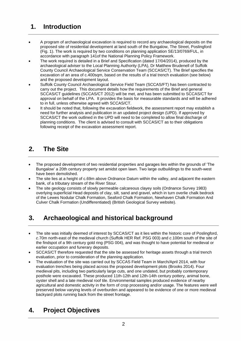
A program of archaeological excavation is required to record any archaeological deposits on the proposed site of residential development at land south of the Bungalow, The Street, Poslingford (Fig. 1). The work is required by two conditions on planning application SE/13/0769/FUL, in accordance with paragraph 141of the National Planning Policy Framework.
The work required is detailed in a Brief and Specification (dated 17/04/2014), produced by the archaeological adviser to the Local Planning Authority (LPA), Dr Matthew Brudenell of Suffolk County Council Archaeological Service Conservation Team (SCCAS/CT). The Brief specifies the excavation of an area of c.400sqm, based on the results of a trial trench evaluation (see below) and the proposed development layout.
Suffolk County Council Archaeological Service Field Team (SCCAS/FT) has been contracted to carry out the project. This document details how the requirements of the Brief and general SCCAS/CT guidelines (SCCAS/CT 2012) will be met, and has been submitted to SCCAS/CT for approval on behalf of the LPA. It provides the basis for measurable standards and will be adhered to in full, unless otherwise agreed with SCCAS/CT.
It should be noted that, following the excavation fieldwork, the assessment report may establish a need for further analysis and publication in an updated project design (UPD). If approved by SCCAS/CT the work outlined in the UPD will need to be completed to allow final discharge of planning conditions. The client is advised to consult with SCCAS/CT as to their obligations following receipt of the excavation assessment report.
2. The Site
The proposed development of two residential properties and garages lies within the grounds of ‘The Bungalow’ a 20th century property set amidst open lawn. Two large outbuildings to the south-west have been demolished.
The site lies at a height of c.69m above Ordnance Datum within the valley, and adjacent the eastern bank, of a tributary stream of the River Stour.
The site geology consists of slowly permeable calcareous clayey soils (Ordnance Survey 1983) overlying superficial Head deposits of clay, silt, sand and gravel, which in turn overlie chalk bedrock of the Lewes Nodular Chalk Formation, Seaford Chalk Formation, Newhaven Chalk Formation And Culver Chalk Formation (Undifferentiated) (British Geological Survey website).
3. Archaeological and historical background
The site was initially deemed of interest by SCCAS/CT as it lies within the historic core of Poslingford, c.70m north-east of the medieval church (Suffolk HER Ref. PSG 003) and c.100m south of the site of the findspot of a 9th century gold ring (PSG 004), and was thought to have potential for medieval or earlier occupation and funerary deposits.
SCCAS/CT therefore requested that the site be assessed for heritage assets through a trial trench evaluation, prior to consideration of the planning application.
The evaluation of the site was carried out by SCCAS Field Team in March/April 2014, with four evaluation trenches being placed across the proposed development plots (Brooks 2014). Four medieval pits, including two particularly large cuts, and one undated, but probably contemporary posthole were excavated. These produced 11th-12th and 12th-14th century pottery, animal bone, oyster shell and a late medieval roof tile. Environmental samples produced evidence of nearby agricultural and domestic activity in the form of crop processing and/or usage. The features were well preserved below varying levels of overburden and appeared to be evidence of one or more medieval backyard plots running back from the street frontage.
4. Project Objectives

3
The aim of the project is to ‘preserve by record’ all archaeological deposits within the defined excavation area, prior to its development, and to produce a post-excavation assessment report.
The project will: Excavate and record all archaeological deposits present on the site. Assess the potential of the site to address research aims defined in the Regional Research
Framework for the Eastern Counties (Brown and Glazebrook 2000, Medlycott 2011). These aims are likely to relate to general themes for the medieval period concerning rural settlement, agriculture and industry, including specific topics such as the dynamics of medieval settlement, the origins and development of rural settlements, the form and function of farmsteads with particular reference to the range of building types or size and shape of fields, and the relationship between rural and urban sites, particularly through study of the production and processing of food for urban markets and the interchange between rural food supplies and urban industrial and craft products. The site may also provide data for further study of medieval pottery industries, both at a local and regional scale.
Provide an updated project design with proposals and a timetable for further analysis, dissemination and archive deposition.
Provide sufficient information for the client to establish any further cost implications for the development regarding the application areas heritage assets.
Figure 1. Location map - REMOVED
© Crown Copyright. All rights reserved. Suffolk County Council Licence No. 100023395 2014.
Figure 2. Excavation area plan

4
5. Archaeological method statement
5.1. Management
The project will be managed by SCCAS/FT Project Officer John Craven in accordance with the principles of Management of Research in the Historic Environment (MoRPHE, English Heritage 2006).
SCCAS/CT will be given ten days notice of the commencement of the fieldwork and arrangements made for SCCAS/CT visits to enable the works to be monitored effectively.
Full details of project staff, including sub-contractors and specialists are given in section 6 below.
5.2. Project preparation
An event number has been obtained from the Suffolk HER Officer (PSG 020) and will be included on all future project documentation.
An OASIS online record has been initiated (suffolkc1-178184) and key fields in details, location and creator forms have been completed.
A pre-site inspection and Risk Assessment for the project has been completed.
5.3. Fieldwork
Excavation
Fieldwork standards will be guided by ‘Standards for Field Archaeology in the East of England’, EAA Occasional Papers 14, and the Institute For Archaeology’s (IFA) paper ‘Standard and Guidance for archaeological field evaluation’, revised 2008.
The archaeological fieldwork will be carried out by members of SCCAS/FT led by a Project Officer (TBC). The fieldwork team will be drawn from a pool of suitable staff at SCCAS/FT and will include an experienced metal detectorist/excavator.
The project Brief requires the excavation of a 400sqm area, encompassing evaluation trenches 01 and 02 and the footprints of the two proposed properties (Fig. 2). If necessary minor modifications to the excavation plan may be made onsite to respect any previously unknown buried services, areas of disturbance/contamination or other obstacles.
The site location will be marked out using an RTK GPS system. The trenches will be excavated using a machine equipped with a back-acting arm and toothless
ditching bucket (measuring at least 1.8m wide), under the supervision of an archaeologist. This will involve the removal of an estimated 0.3m-0.6m of topsoil or modern deposits until the first visible archaeological surface or subsoil surface is reached.
The location of spoil heaps will be determined by the client who are in possession of the site and supplying plant. Spoil heaps will be examined and metal-detected for archaeological material.
The excavation of all archaeological deposits will be by hand, including stratified layers, unless it can be demonstrated to the satisfaction of SCCAS/FT that no information will be lost by using a machine. All features will be excavated by hand unless otherwise agreed with SCCAS/CT. Typically 50% of discrete features such as pits and 10% of linear features (in 1m slots) will be sampled by hand excavation, although significant archaeological features such as solid or bonded structural remains, building slots or postholes will be examined in section then 100% excavated. Occupation levels and building fills will be sieved using a 10mm mesh.
Any fabricated surface (floors, yards etc) will be fully exposed and cleaned. Metal detector searches will take place throughout the excavation by an experienced SCCAS/FT
metal-detectorist. Environmental sampling of archaeological contexts will, where possible, be carried out to assess the
site for palaeoenvironmental remains and will follow appropriate guidance (English Heritage 2011). In order to obtain palaeoenvironmental evidence, bulk soil samples (of at least 40 litres each, or 100% of the context) will be taken using a combination of judgement and systematic sampling from selected archaeological features or natural environmental deposits, particularly those which are both datable

5
and interpretable. All samples will be retained until an appropriate specialist has assessed their potential for palaeoenvironmental remains. Decisions will be made on the need for further analysis following these assessments.
If necessary, for example if waterlogged peat deposits are encountered, then advice will be sought from the English Heritage Regional Advisor for Archaeological Science (East of England) on the need for specialist environmental techniques such as coring or column sampling.
The depth and nature of colluvial or other masking deposits across the site will be recorded.
Site recording
An overall site plan showing feature positions, sections and levels will be made using an RTK GPS or Total Station Theodolite. Individual detailed trench or feature plans etc will be recorded by hand at 1:10, 1:20 or 1:50 as appropriate to complexity. All excavated sections will be recorded at a scale of 1:10 or 1:20, also as appropriate to complexity. All such drawings will be in pencil on A3 pro forma gridded permatrace sheets. All levels will refer to Ordnance Datum. Section and plan drawing registers will be maintained.
The site, and all archaeological features and deposits will be recorded using standard pro forma SCCAS/FT registers and recording sheets and numbering systems. Record keeping will be consistent with the requirements of the Suffolk HER and will be compatible with its archive.
A photographic record, consisting of high resolution digital images, will be made throughout the evaluation. A number board displaying site code and, if appropriate, context number and a metric scale will be clearly visible in all photographs. A photographic register will be maintained.
All pre-modern finds will be kept and no discard policy will be considered until all the finds have been processed and assessed. Finds on site will be treated following appropriate guidelines (Watkinson & Neal 2001) and a conservator will be available for on-site consultation as required.
All finds will be brought back to the SCCAS/FT finds department at the end of each day for processing, quantifying, packing and, where necessary, preliminary conservation. Finds will be processed and receive an initial assessment during the fieldwork phase and this information will be fed back to site to inform the on-site excavation methodology.
If human remains are encountered guidelines from the Ministry of Justice will be followed. Human remains will be treated at all stages with care and respect, and will be dealt with in accordance with the law and the provisions of Section 25 of the Burial Act 1857. The evaluation will attempt to establish the extent, depth and date of burials whilst leaving remains in situ. If human remains are to be lifted, for instance if analysis is required to fully evaluate the site, then a Ministry of Justice license for their removal will be obtained in advance. In such cases appropriate guidance (McKinley & Roberts 1993, Brickley & McKinley 2004) will be followed and, on completion of full recording and analysis, the remains, where appropriate, will be reburied or kept as part of the project archive.
In the event of unexpected or significant deposits being encountered on site, the client and SCCAS/CT will be informed. Such circumstances may necessitate changes to the Brief and hence excavation methodology, in which case a new archaeological quotation will have to be agreed with the client, to allow for the recording of said unexpected deposits. If the excavation is aborted, i.e. because unexpected deposits have made the development unviable or led to other mitigation measures such as project redesign, then all exposed archaeological features will be recorded as usual prior to completion of fieldwork and a PXA report produced.
Fieldwork will not end without the prior approval of SCCAS/CT. On completion the site will be handed over to the client, to either backfill or begin development.
Outreach
Due to the small size and likely short duration of the project outreach activities such as an open day or tours for the general public, local schools, councillors, societies etc, are unlikely to be viable. If warranted, and the site is not deemed too archaeologically sensitive, a press release will be issued to local media and information boards will placed on the site perimeter alongside The Street during the fieldwork stage of investigation.

6
5.4. Post-excavation
The post-excavation finds work will be managed by the SCCAS/FT Finds Team Manager, Richenda Goffin, with the overall post-excavation managed by John Craven. Specialist finds staff, whether internal SCCAS/FT personnel or external specialists, are experienced in local and regional types and periods for their field.
All finds will be processed and marked (HER site code and context number) following ICON guidelines and the requirements of the Suffolk HER. For the duration of the project all finds will be stored according to their material requirements in the SCCAS Archaeological Stores at Bury St. Edmunds or Ipswich. Metal finds will be stored in accordance with ICON) guidelines, initially recorded and assessed for significance before dispatch to a conservation laboratory within 4 weeks of the end of the excavation. All pre-modern silver, copper alloy and ferrous metal artefacts and coins will be x-rayed if necessary for identification. Sensitive finds will be conserved if necessary and deposited in bags/boxes suitable for long term storage to ICON standards. All coins will be identified to a standard acceptable to normal numismatic research.
All on-site derived site data will be entered onto a digital (Microsoft Access) SCCAS/FT database compatible with the Suffolk HER.
Bulk finds will be fully quantified and the subsequent data will be added to the digital site database. Finds quantification will fully cover weights and numbers of finds by context and will include a clear statement for specialists on the degree of apparent residuality observed.
Assessment reports for all categories of collected bulk finds will be prepared in-house or commissioned as necessary and will meet appropriate regional or national standards. Specialist reports will include sufficient detail and tabulation by context of data to allow assessment of potential for analysis and will include non-technical summaries.
Representative portions of bulk soil samples from archaeological features will be processed by wet sieving and flotation in-house in order to recover any environmental material which will be assessed by external specialists. The assessment will include a clear statement of potential for further analysis.
All hand drawn site plans and sections will be scanned. All raw data from GPS or TST surveys will be uploaded to the project folder, suitably labelled and
kept as part of the project archive. Selected plan drawings will then be digitised as appropriate for combination with the results of digital
site survey to produce a full site plan, compatible with MapInfo GIS software. All hand-drawn sections will be digitised using autocad software. Digital photographs will be allocated and renumbered with a code from the Suffolk HER photographic
index.
5.5. Report
A full post-excavation assessment report (PXA) will be produced, consistent with the principles of Management of Research in the Historic Environment (MoRPHE, English Heritage 2006). If the fieldwork results do not warrant such an assessment SCCASD/CT will be asked to approve the production of a full archive report.
The PXA report will contain a description of the project background, location plans, excavation methodology, a period by period description of results, finds assessments and a full inventory of finds and contexts. The report will also include scale plans, sections drawings, illustrations and photographic plates as required.
The PXA will present a clear and concise assessment of the archaeological value and significance of the results, and identify the site’s research potential in the context of the Regional Research Framework for the East of England (Brown and Glazebrook, 2000, Medlycott 2011). This will include an assessment of potential research aims that could be addressed by the site evidence.
The PXA will include an Updated Project Design, with a timetable, for analysis, dissemination and archive deposition.
The report will contain sufficient information to stand as an archive report should further publication not be required.
The report will include a summary in the established format for inclusion in the annual ‘Archaeology in Suffolk’ section of the Proceedings of the Suffolk Institute of Archaeology and History.
A copy of this Written Scheme of investigation will be included as an appendix in the report. The report will include a copy of the completed project OASIS form as an appendix. An unbound draft copy of the report will be submitted to SCCAS/CT for approval within 6 months of
completion of fieldwork.

7
5.6. Project archive
On approval of the report a printed and bound copy will be lodged with the Suffolk HER. A digital .pdf file will also be supplied, together with a digital and fully georeferenced vector plan showing the application area and trench locations, compatible with MapInfo software.
The online OASIS form for the project will be completed and a .pdf version of the report uploaded to the OASIS website for online publication by the Archaeological Data Service. A paper copy of the form will be included in the project archive.
A second bound copy of the report will be included with the project archive (see below). A digital .pdf copy of the approved report will be supplied to the client, together with our final invoice
for outstanding fees. Printed and bound copies will be supplied to the client on request. The project archive, consisting of the complete artefactual assemblage, and all paper and digital
records, will be deposited in the SCCAS Archaeological Store at Bury St Edmunds within 6 months of completion of fieldwork. The project archive will be consistent with MoRPHE (English Heritage 2006) and ICON guidelines. The project archive will also meet the requirements of SCCAS (SCCAS/CT 2010).
All physical site records and paperwork will be labelled and filed appropriately. Digital files will be stored in the relevant SCCAS archive parish folder on the SCC network site.
The project costing includes a sum to meet SCCAS archive charges. A form transferring ownership of the archive to SCCAS will be completed and included in the project archive.
If the client, on completion of the project, does not agree to deposit the archive with, and transfer to, SCCAS, they will be expected to either nominate another suitable depository approved by SCCAS/CT or provide as necessary for additional recording of the finds archive (such as photography and illustration) and analysis. A duplicate copy of the written archive in such circumstances would be deposited with the Suffolk HER.
Exceptions from the deposition of the archive described above include: Objects that qualify as Treasure, as detailed by the Treasure Act 1996. The client will be informed as
soon as possible of any such objects are discovered/identified and the find will be reported to SCCAS/CT and the Suffolk Finds Liaison Officer and hence the Coroner within 14 days of discovery or identification. Treasure objects will immediately be moved to secure storage at SCCAS and appropriate security measures will be taken on site if required. Any material which is eventually declared as Treasure by a Coroner’s Inquest will, if not acquired by a museum, be returned to the client and/or landowner. Employees of SCCAS, or volunteers etc present on site, will not eligible for any share of a treasure reward.
Other items of monetary value in which the landowner or client has expressed an interest. In these circumstances individual arrangements as to the curation and ownership of specific items will be negotiated.
Human skeletal remains. The client/landowner by law will have no claim to ownership of human remains and any such will be stored by SCCAS, in accordance with a Ministry of Justice licence, until a decision is reached upon their long term future, i.e. reburial or permanent storage.
Bibliography
Brickley, M., and McKinley, J. I., 2004, Guidelines to the Standards for Recording Human Remains. IFA Professional Practice Paper No 7.
Brooks, R., 2014, Land south of the Bungalow, Poslingford, PSG 020. SCCAS Report No. 2014/043.
Brown, N and Glazebrook, J. (Eds), 2000, Research and Archaeology: a Framework for the Eastern Counties, 2. Research Agenda and Strategy. East Anglian Archaeology Occasional Paper No. 8.
English Heritage, 2006, Management of Research in the Historic Environment (MoRPHE).
English Heritage, 2011, Environmental archaeology, A Guide to the Theory and Practice of Methods, from Sampling and Recovery to Post-excavation (2nd Ed).
Gurney, D., 2003, Standards for Field Archaeology in the East of England. East Anglian Archaeology Occasional Paper No 14.
Institute for Archaeologists, 2008, Standard and Guidance for archaeological field evaluation.
McKinley, J., I and Roberts, C., 1993, Excavation and post-excavation treatment of cremated and

8
inhumed human remains. IFA Technical Paper No 13.
Medlycott, M. (Ed), 2011, Research and Archaeology Revisited: A revised framework for the East of England. EAA Occasional Paper 24.
SCCAS/CT, 2010, Deposition of Archaeological Archives in Suffolk.
SCCAS/CT, 2012, Requirements for Archaeological Excavation 2012.
Watkinson, D. and Neal, V., 2001, First Aid for Finds. Third Edition, revised. Rescue/UKIC Archaeology Section, London.
6. Project Staffing
Management
SCCAS/FT Manager Western Office Dr Rhodri Gardner
SCCAS/FT Project Manager John Craven
SCCAS/FT Finds Dept Richenda Goffin
SCCAS/FT Graphics Dept Crane Begg
Fieldwork
The fieldwork team will be derived from the following pool of SCCAS/FT staff.
Name Job Title First Aid Other skills/qualifications
John Craven Project Officer
Robert Brooks Project Officer Yes Surveyor
Andrew Beverton Project Officer Yes Surveyor
Simon Picard Supervisor Surveyor
John Sims Supervisor Yes
Preston Boyle Senior Project Assistant
Phil Camps Senior Project Assistant Yes Shoring. 360 machine and dumper driver.
Mobile tower.
Steve Manthorpe Senior Project Assistant
Tim Carter Project Assistant Metal detectorist
Alan Smith Project Assistant Metal detectorist
Post-excavation and report production
The production of the site report and submission of the project archive will be carried out by the fieldwork Project Officer. The post-excavation finds analysis will be managed by Richenda Goffin. The following SCCAS/FT specialist staff will contribute to the report as required.

9
Graphics Crane Begg
Graphics Ellie Cox, Gemma Bowen, Beata Wieczorek-Olesky
Illustration Donna Wreathall
Post Roman pottery and CBM Richenda Goffin
Roman Pottery Cathy Tester, Stephen Benfield
Environmental sample processing Anna West
Finds Processing Jonathan Van Jennians
SCCAS also uses a range of external consultants for post-excavation analysis who will
be sub-contracted as required. The most commonly used of these are listed below.
Sue Anderson Human skeletal remains Freelance Sarah Bates Lithics Freelance Julie Curl Animal bone Freelance Anna Doherty Prehistoric pottery Archaeology South-East Val Fryer Plant macrofossils Freelance SUERC Radiocarbon dating Scottish Universities Environmental
Research Centre

10
WSI Appendix 1. Health and Safety
1. Introduction
The project will be carried out following Suffolk County Council Health and Safety Policies at all times. All staff will be aware that they have a responsibility to: Take care of their own health and safety and that of others who maybe affected by what they do, or
fail to do, at work. Follow safe systems of work and other precautions identified in the risk assessment. Report any changes to personal circumstances that may affect their ability to work safely. Report potential hazards, incidents and near misses to the Project Officer/supervisor. A pre-site inspection has been made of the site and applicable SCCAS/FT Risk Assessments for the project are included below. All SCCAS/FT staff are experienced in working on a variety of archaeological sites and permanent staff all hold a CSCS (Construction Skills Certification Scheme) card. All staff have been shown the SCCAS Health and Safety Manual, copies of which are held at the SCCAS/FT offices in Ipswich and Bury St Edmunds. All staff will read the site WSI and Risk Assessments and receive a site safety induction from the Project Officer prior to starting work. All staff will be issued with appropriate PPE. From time to time it may be necessary for site visits by other SCCAS/FT staff, external specialists, SCCAS/CT staff or other members of the public. All such staff and visitors will be issued with the appropriate PPE and will undergo the required inductions. Site staff, official visitors and volunteers are all covered by Suffolk County Council insurance policies. SCC also has professional negligence insurance. Copies of these policies are available on request.
2. Specific site issues
Welfare facilities Due to the limited nature of the project, it is proposed that SCCAS/FT staff will work from their vehicle and use client welfare facilities if available. If not staff will be able to travel to public facilities. Additional facilities, toilet, site accommodation etc, will be provided if the project is extended. Fresh, clean water for drinking and hand washing is carried in SCCAS vehicles. A vehicle will be on site at all times. First Aid A member of staff with the First Aiders at Work qualification will be on site at all times. A First Aid kit and a fully charged mobile will also be in vehicle/on site at all times. Site access and security Plant is being supplied by the client who has control of the site. Access will be via the existing property entrance off The Street. The site is private property, secured by the client, and not open to public access. Deep excavation Due to Health and Safety considerations, excavations will be limited to a maximum depth of 1.2m below existing ground level unless the excavation area is stepped or shored. In practice the excavation is likely to be c.0.6m deep. On completion of the project the excavation area will be returned to the client who will decide whether to backfill etc prior to development. Contaminated ground Details of any ground contamination have not been provided by the client. If any such is identified then groundworks will cease until adequate safety and environmental precautions are in place. Advice will be sought from HSE and relevant authorities if required concerning any of these issues. Hazardous Substances No hazardous substances are specifically required in order to undertake the archaeological works.

11
Underground services Details of known services have not been provided by the client. The excavation will be modified with reference to any service plan supplied and a CAT scanner used prior to excavation. Overhead Power lines Overhead power lines pass near the north-west corner of the site. Plant operations will maintain a safe working distance, with hazard tape/barrier fencing being used to demarcate safe limits if required. Personal Protective Equipment (PPE) The following PPE is issued to all site staff as a matter of course. Additional PPE will be provided if deemed necessary. Hard Hat (to EN397). High Visibility Clothing (EN471 Class 2 or greater). Safety Footwear (EN345/EN ISO 20346 or greater – to include additional penetration-resistant
midsole). Gloves (to EN388). Eye Protection (safety glasses to at least EN 166 1F).
Environmental impact/constraints
Suffolk County Council maintains an internal Environmental Management System run in accordance with the ISO14001 standard by a dedicated EMS officer. The council has a publicly available Environment Policy, which commits us to meeting all relevant regulatory, legislative and other requirements, preventing pollution, and to continually improving our environmental performance. All existing and new SCCAS subcontractors are issued annually with the SCC Environmental Guidance Note For Contractors. On site the SCCAS Project Officer will monitor environmental issues and will alert staff to possible environmental concerns. In the event of spillage or contamination, e.g. from plant or fuel stores, EMS reporting and procedures will be carried out in consultation with Jezz Meredith (SCCAS/FT EMS Officer). There are no environmental constraints upon the development area and the excavation will not have any impact on any trees or sensitive flora and fauna or their habitats. . All rubbish will be bagged and removed either to areas designated by the client or returned to SCCAS for disposal. Water will not be pumped into any water course, storm drain etc without prior consent from the Environment Agency. Procedures for dealing with contamination from fuel spills or sediments will be closely followed.

12
3. Project Contacts
SCCAS/FT
SCCAS/FT Manager Western Office Dr Rhodri Gardner 01473 581473 SCCAS/FT Project Manager John Craven 01284 741249 SCCAS/FT Finds Dept Richenda Goffin 01284 741233 SCCAS/FT H&S Stuart Boulter 01473 583290 SCCAS/FT EMS Jezz Meredith 01473 583288 SCCAS/FT Outreach Officer Duncan Allan 01473 583288
Emergency services
Local Police Raingate Street, Bury St Edmunds, IP33 2AP
101
Local GP Hardwicke House Group Practice, Nethergate Street, Clare, Sudbury, Suffolk, CO10 8NP
01787 278999
Location of nearest A&E West Suffolk Hospital, Hardwick Lane, Bury St. Edmunds, Suffolk, IP33 2QZ
01284 713000
Environment Agency Customer Services Line (8am to 6pm) 03708 506 506 24 hour Emergency Hotline 0800 807060 Essex and Suffolk Water 24 hour Emergency Hotline 0845 782 0999 National Gas Emergency Service Gas emergency hotline 0800 111 999 UK Power Networks East England electricity emergency hotline 0800 783 8838 Anglian Water 24 hour Emergency Hotline 08457 145 145
Client contacts
Client Row Build Ltd 01787 310910 Client Agent Site landowner
Archaeological contacts
Curator Dr Matthew Brudenell 01284 741227 Consultant EH Regional Science Advisor Zoe Outram 01223 582707
Sub-contractors
Plant hire Client provided Misc. Equipment hire Toilet/facilities hire
Other
SCC Press Office Andrew St Ledger (Chief Press Officer) 01473 264398 SCC Fleet Maintenance 01359 270777 SCC Environment Strategy Manager Emma Flint 01473 264810 SCC Health and Safety Advisor (ESE)
Mark Ranson 01473 261494
SCC Corporate H&S Manager Dave Atkinson 01473 260513

4. Risk Assessments - REMOVED
A pre-site inspection and assessment has been made of the site and the following
SCCAS/FT Risk Assessments apply to the project and are included below.
SCCAS/FT RA1 Working with plant machinery
SCCAS/FT RA2 Manual excavation and outdoor working
SCCAS/FT RA3 Deep excavations
SCCAS/FT RA4 Use of Hand tools
SCCAS/FT RA5 Damage to services

Appendix 2. Context listContext No Feature No Feature TypeGrid Sq. Description Length Width Depth Phase SpotdateGroup NoSmall Finds Cuts Cut by Over Under Finds Sample
0001 Dark greyish-brown firm silty-clay, with moderate levels of small-medium angular and rounded flints. Clear horizon clarity.
Topsoil present across all of site.
0.1-0.Topsoil Layer 0002 No No0001
0002 Very dark greyish-brown firm silty-clay, with frequent small-medium angular and rounded flints. Clear horizon clarity. Found in Trenches 1 and 2. Much higher stone context in Trench 1, presumably relating to the river terrace geology here.
Subsoil layer.
0.15-Subsoil Layer 0001 No No0002
0003 Single fill of 0004. Dark brownish-grey compact silty-clay, with occasional small rounded and angular flints. Clear horizon clarity.
Fill of possible pit [thought to be a pit in evaluation, but then found to be a ditch in excavation].
Ditch Fill 00400004 No No0004
0004 Shape in plan suggests a ditch turning a corner, but the cut was shallow, possibly like a large pit. The sides sloped initially at c.45° before curving to the wide slightly concave base. Filled with 0003.
Large pit/pits, or a cornering ditch. [Found to be a ditch in the excavation and possibly relates to the feature in the west end of Trench 3 - 0013].
>3.2 >1.8 0.25Ditch Cut 00400003 No No0004
0005 Single fill of pit 0006 as excavated so far. Dark brownish-grey compact silty-clay, with occasional small rounded and angular flints, moderate charcoal flecks and occasional chalk flecks. Re-excavated as 0026 in excavation. Finds can be analysed in conjunction with those from 0026.
Fill of pit 0006. Contains domestic refuse and charcoal.
>0.7Pit Fill 0006 No No0006
0006 Pit cut is probably circular in plan, with initially vertical sides that then undercut the top of the pit. Not fully excavated as pit was filling with water! Re-excavated as 0018 during excavation.
Pit cut. Domestic pit cut.
1.35 >0.8 >0.7Pit Cut 0005 No No0006
0007 Single posthole fill. Dark greyish-brown loose silty-clay, with occasional small-medium angular and rounded flints. Clear horizon clarity.
Posthole fill.
Posthole Fill 0008 No No0008
0008 Round posthole cut in plan, with steep sides at c.75°, which have a rapidly curving break of slope to the flat base.
Well defined posthole cut.
0.38 0.34 0.08Posthole Cut 0007 No No0008
0009 Excavated in evaluation and described as:Top fill of pit. Firm mid-dark brownish-grey clay-silt mix with common small chalk flecks and nodules, and occasional medium-large flints. Diffuse horizon clarity. Separated in the excavation into three separate fills 0024, 0044 and 0045.
Pit fill.
1.47 0.48Pit Fill 0010 No No0011

Context No Feature No Feature TypeGrid Sq. Description Length Width Depth Phase SpotdateGroup NoSmall Finds Cuts Cut by Over Under Finds Sample
0010 Basal(?) fill of pit 0011. Firm dark grey clay-silt mix, with common variable flints and occasional chalk flecks. Clear horizon clarity with natural. Not fully excavated. Re-excavated during excavation and divided into fills 0019, 0020, 0021, 0044 and 0045.
Lowest excavated fill of pit. Quite organic - domestic waste?
1.16 0.28Pit Fill 0024 0009 No No0011
0011 First described in evaluation as:Irregular shaped cut in plan, possibly consisting of two round/oval pit cuts. Fairly shallow poorly defined upper limits that then become vertical and overhang slightly in places. The base is stepped and may suggest several cuts. Re-excavation in excavation suggests three cuts - 0011, 0022 and 0025.Fully excavated in excavation and described as:Sub oval in plan, N-S. Very steep almost vertical sides with sharp break of slope at top and base. Flat to slightly concave base. Cuts pit [0025].
Cut of pit. Cuts pit 0025 to its south. Medieval pot finds recovered. Part of three pits all intercutting.
1.0m i 1.47 0.60Pit Cut 0021 0024 No No0011
0012 Very dark grey compact silty-clay, with frequent charcoal flecks and small-medium angular and rounded flints. Clear horizon clarity.
Basal excavated pit fill. See also 0014 and 0015.
0.3Pit Fill 0013 No No0013
0013 Shape in plan unclear. One straight NW-SE edge revealed in plan. 35-40° sloping concave NE edge, which gradually curves to the flat base.
Large shallow pit? Or a very wide shallow ditch? [Possibly a continuation of over machined ditch 0004/ditch group 0040].
>3.3 >1.8 0.3Pit Cut 0012 No No0013
0014 Mid brownish-grey compact silty-clay, with occasional small chalk and flint nodules. Only uncovered by machine at the end of the trench - not hand excavated.
Possibly the upper fill of feature 0013.
Pit Fill No No0013
0015 Very dark grey compact silty-clay, with frequent charcoal flecks and small-medium angular and rounded flints.
Possibly the same as 0012, but not excavated, so relationship not established. Fill of feature 0013.
Pit Fill No No0013
0016 Pale-mid brownish-grey firm clayey-silt, with occasional chalk nodules and stones. Clear horizon with natural geology. Only recorded in Trenches 3 and 4 - not the same as subsoil 0002 in Trenches 1 and 2.
Subsoil layer.
0.26-Subsoil Layer No No0016
0017 Number given to topsoil across the site. Partially consists of an imported/built-up topsoil near the street frontage and also a buried topsoil. Finds recovered from this are medieval and post-medieval.
Topsoil.
Topsoil Layer Yes No0017

Context No Feature No Feature TypeGrid Sq. Description Length Width Depth Phase SpotdateGroup NoSmall Finds Cuts Cut by Over Under Finds Sample
0018 Large pit, originally recorded as 0006 in evaluation. 25% excavated in evaluation, extended to 50% in excavation. Slightly oval in plan, aligned north-south. Sides slope at 70°-80° for top 0.15m then undercut quite abruptly, with curving break of slope to the slightly concave base.
Pit cut. Quarrying clay for house building? Not deep enough to be a well. Secondary use for refuse.
1.78 1.68 1.05Pit Cut 0027 No No0018
0019 Yellowish-brown slightly silty clay, compact, good horizon, no inclusions.
Basal fill of pit [0025]. 2 pieces of medieval pot recovered.
0.58 0.08Pit Fill 0025 0020 Yes No0025
0020 Dark brownish-grey slightly clayey silt, mod angular flints, good horizon clarity, middle fill.
Middle fill of pit [0025], ceramic building material and oyster shell recovered.
0.48 0.22Pit Fill 0019 0021 Yes No0025
0021 Light to mid yellowy grey clayey silt, loose, moderate angular flints, good horizon clarity. 2 pieces of medieval pot recovered.
Upper fill of pit [0025]. Medieval pot recovered.
0.90 0.28Pit Fill 0020 0011 Yes No0025
0022 U shaped in profile, very steep almost vertical sides, sharp break of slope at top, mod break of slope at base. Concave base. Cut by pit [0025].
Cut of small pit [0022]. No finds within it, but assumed medieval or earlier, as cut by medieval pit to its north.
0.38 0.24Pit Cut 0023 No No0022
0023 Light to mid brownish-grey, slightly clayey silt. Compact. Mod small gravel and angular small flints. Good horizon clarity.
Single fill of small pit [0022]. No finds within.
0.38 0.24Pit Fill 0022 0025 No No0022
0024 Light yellowy grey gravelly silty clay, compact, no finds.
Basal fill of pit [0011], no finds within.
1.24 0.10Pit Fill 0011 0044, 0010
No No0011
0025 Appears to be sub oval in plan, not much visible. Mod steep south side, fairly sharp break of slope at top and base. Flat to concave base. Cut by pit [0011 and cuts pit [0022].
Cut of pit [0025]. Three fills, medieval in date (pot recovered).
2.23 >1.2 0.34Pit Fill 0023 0019 No No0034
0026 Fill - same as 0005 from evaluation. Upper fill of pit 0006/0018. Dark brownish-grey compact silty-clay, with occasional small rounded and angular flints, moderate charcoal flecks and occasional chalk flecks.
Upper fill of pit 0006/0018. Contains domestic refuse and charcoal.
0.76Pit Fill 0027 Yes No0018
0027 Mid-dark firm-cohesive grey clayey-silt, with frequent small to medium rounded-angular flints. Sharp horizon with clay natural. Basal fill. No finds collected as hard to differentiate from 0005/0026.
Basal pit fill. Probably same as 0005/0026, but with some natural clay and stone inclusions from trample of base/collapse of sides.
0.3Pit Fill 0018 0026 No No0018

Context No Feature No Feature TypeGrid Sq. Description Length Width Depth Phase SpotdateGroup NoSmall Finds Cuts Cut by Over Under Finds Sample
0028 Irregular/sub-rounded cut in plan, very shallow, with very gradual slope to north, slightly more sloping to the south. Flat to slightly concave base. Single fill.
Cut of very shallow possible pit to southern end of site.
0.9 0.06Pit Cut 0029 No No0028
0029 Very dark grey/black very organic silt. Firm/compact. Occasional small sub-angular flints. Good horizon clarity. Single fill.
Single fill of pit 0028.
0.9 0.06Pit Fill 0028 Yes Yes0028
0030 Oval in plan, running NW-SE. Generally U-shaped in profile, but with a wide almost flat base. Shallower at SE end.
Cut of posthole, possibly a second one at its south-east end, but more likely just a dip in the natural.
0.73 0.62 0.16Posthole Cut 0031 No No0030
0031 Dark brownish-grey compact/firm silt. No inclusions. Good horizon with natural. Single fill.
Single fill of posthole.
0.72 0.16Posthole Fill 0030 Yes Yes0041
0032 Linear cut in plan, with moderately sloping sides. Slightly concave-flat base. Running west to east across north end of site.
Cut of ditch. Cut to east by modern pond. Thick silting(?) layer makes up basal fill (sampled). All finds retrieved from middle fill.
3.52 0.56Ditch Cut 00400033 No No0032
0033 Light to mid grey slightly silty-clay. Compact and very cohesive. Occasional small angular flints. Basal fill with good horizon with natural.
Basal fill of ditch. Appears to be a silty layer from initial silting of the ditch.
1.68 0.17Ditch Fill 00400032 0034 No No0032
0034 Very dark grey/black very silty organic material with frequent charcoal and occasional sub-rounded flints. Good horizon clarity. Compact and cohesive. Same as 0004 from evaluation where it was sampled (sample 1).
Main organic build up after initial ditch silting. Only fill with finds.
3.12 0.52Ditch Fill 00400033 0035 Yes No0032
0035 Mid to dark brownish-grey slightly organics gravelly-silt. Line of small-medium flints loosely gathered at base of fill, with fewer to the south. Lens of light yellowish-orange material along the base of the fill at the southern end. Good horizon with topsoil above.
Upper fill in ditch 0032. Slightly less organic than fill below and no finds.
2.91 0.31Ditch Fill 00400034 No Yes0032
0036 Dark grey firm-cohesive clayey-silt, with common small stones and occasional chalk and charcoal flecks. Sharp horizon clarity with natural. Single fill.
Pit fill. No clear evidence of burnt material in fill, despite possible burnt discolouration around the pit.
Pit Fill 0037 Yes Yes0037

Context No Feature No Feature TypeGrid Sq. Description Length Width Depth Phase SpotdateGroup NoSmall Finds Cuts Cut by Over Under Finds Sample
0037 Oval cut(s) aligned north to south, positioned on the southern edge of ditch 0039. No relationship in section. Ditch possibly cuts 0037 in plan, but very unclear. 35°-80° concave to convex variable sides, curving to an uneven base. Patches of possibly heated red sand around cut.
Pit cut. Possibly used for a fire, but very little burnt material in fill. May actually be two small cuts, but probably just irregular within the natural that consists of large stones in a sand matrix.
>1.15 0.75 0.28Pit Cut 0036 No No0037
0038 Dark grey firm cohesive clayey-silt with common small stones and occasional charcoal flecks. Clear horizon with natural. Single fill.
Ditch fill. Probable the same material as 0034 in cut 0032.
Ditch Fill 0040SF1001 0039 Yes No0039
0039 Cut through ditch to try and find relationship with pit 0037 - no clear definition. Ditch only part-excavated. 40°-45° irregular southern side. Not bottomed. North side not excavated/truncated by evaluation trench.
Ditch, as seen to west and as 0004 in evaluation.
Ditch Cut 00400038 No No0039
0040 Group number for E-W aligned ditch. Partially aligned with the evaluation trench, so was over-machined in the evaluation works and then mistakenly excavated as a pit - 0004. Excavated in main excavation as 0032 and 0039.
Medieval ditch, cut by modern pond to east edge of site. Where excavated as 0032, it has an unusual lower silty-clay fill.
Ditch Group 0040No No
0041 Has a rounded edge in plan (only partially visible next to west limit of excavation). Very steep sides, with sharp break of slope at base to the concave base.
Cut of possible pit found whilst cleaning west baulk. Single fill with no finds.
>0.84 >0.18 0.38Pit Cut 0042 No No0041
0042 Light to mid yellowish-grey loose gravelly-silt. Good horizon clarity with natural.
Single fill of possible pit.
>0.84 0.38Pit Fill 0041 No No0041
0043 Unstratified finds from the site.Unstratified Finds
Yes No0043
0044 Light yellowish-grey slightly silty-clay, with large angular flints and small gravel. Compacted.
Pit fill.
Pit Fill 0024 0045 Yes No0011
0045 Mid to dark grey loose clayey silt. Frequent med-large angular flints. Upper fill.
Upper fill of pit [0011]. Two pieces of medieval pot found within.
0044 Yes No0011


Appendix 3. OASIS form


Appendix 4. Bulk finds catalogue
Context No
Samp No
Pot No
Pot Wt (g)
CBM No
CBM Wt(g)
F Clay No
F Clay Wt (g)
P-med glass No
P-med glass Wt (g)
Abone No
Abone Wt (g)
Shell No
Shell Wt (g)
Oyster Shell Other
Overall Date
Notes
0017 1 38 1 233 Med/pmed
12th-13th C but 19th C blue medicinal bottle
0019 2 15 L12th-14th C 0020 1 2 1 52 2 13 YES 14th-15th C
0021 2 11 L12th-14th C 1 fe nail @ 1g
0026 13 103 6 33 M12th-M13th C
0029 1 9 2 13 11th-12th C Fragments of hammerscale?
0034 28 329 Mid 11th-12th c?
0036 8 137 3 172 1 11 YES M12th-M13th C
Hammerscale frags in sample? Fruit pips?
0038 5 24 2 30 5 141 M13th-14th C
0043 1 23 12th C+ 0045 2 10 L12th-14th C 0044 0 0 1 106 13 141 13th-15th C 0029 06 2 5 14 25 1 2 YES
0036 09 19 69 3 2 40 1 1 YES 4 bt flint @ 18g
0031
Possible hammerscale (magnetic)
0031 07 1 2 YES Small snails

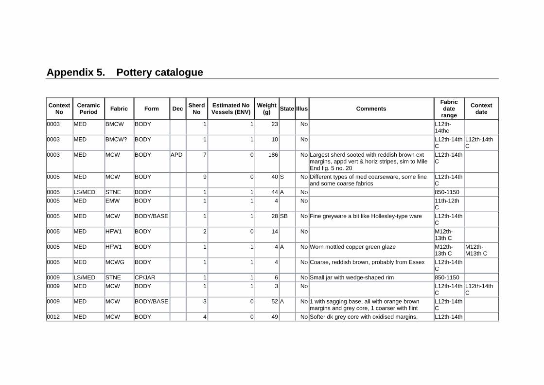
Appendix 5. Pottery catalogue
Context
No Ceramic Period
Fabric Form DecSherd
No Estimated No Vessels (ENV)
Weight (g)
State Illus Comments Fabric date
range
Context date
0003 MED BMCW BODY 1 1 23 No L12th-14thc
0003 MED BMCW? BODY 1 1 10 No L12th-14th C
L12th-14th C
0003 MED MCW BODY APD 7 0 186 No Largest sherd sooted with reddish brown ext margins, appd vert & horiz stripes, sim to Mile End fig. 5 no. 20
L12th-14th C
0005 MED MCW BODY 9 0 40 S No Different types of med coarseware, some fine and some coarse fabrics
L12th-14th C
0005 LS/MED STNE BODY 1 1 44 A No 850-1150
0005 MED EMW BODY 1 1 4 No 11th-12th C
0005 MED MCW BODY/BASE 1 1 28 SB No Fine greyware a bit like Hollesley-type ware L12th-14th C
0005 MED HFW1 BODY 2 0 14 No M12th-13th C
0005 MED HFW1 BODY 1 1 4 A No Worn mottled copper green glaze M12th-13th C
M12th-M13th C
0005 MED MCWG BODY 1 1 4 No Coarse, reddish brown, probably from Essex L12th-14th C
0009 LS/MED STNE CP/JAR 1 1 6 No Small jar with wedge-shaped rim 850-1150
0009 MED MCW BODY 1 1 3 No L12th-14th C
L12th-14th C
0009 MED MCW BODY/BASE 3 0 52 A No 1 with sagging base, all with orange brown margins and grey core, 1 coarser with flint
L12th-14th C
0012 MED MCW BODY 4 0 49 No Softer dk grey core with oxidised margins, L12th-14th

Context No
Ceramic Period
Fabric Form DecSherd
No Estimated No Vessels (ENV)
Weight (g)
State Illus Comments Fabric date
range
Context date
probably Essex products. C
0012 MED MCW BOWL DEEP
2 1 106 No With flange, steep sided, poss similar to Great Horksley products (Drury & Petchey 1975 fig. 13)
13-14th C 13th C?
0012 MED MCW CP/JAR 1 1 32 No Coarse oxidised fabric, everted rm with flattened top. Similar to Rivenhall fig. 39 no. 42-43. 13th C?
L12th-14th C
0012 MED MCW CP/JAR 4 0 58 No Squared rim with flat top Essex type H1, 13th C L12th-14th C
0012 MED BMCW BASE 1 1 18 S No Sagging base L12th-14th C
0017 MED BCSW CP/JAR 1 1 38 No Coarse 'Bury ware' jar, thickened flat topped rim
12th-13th C
12th-13th C
0019 MED MCW BODY 1 1 11 A No Reddish brown core w sl internal sooting L12th-14th C
L12th-14th C
0019 MED BMCW BODY 1 1 4 No L12th-14th C
0020 MED COLC BODY 1 1 2 No Reduced core, red grog or fe oxide L13th-M16th C
L13th-M16th C
0021 MED BMCW BODY 1 1 5 S No L12th-14th C
0021 MED MCW BASE 1 1 6 No Sagging base, sandier fabric L12th-14th C
L12th-14th C
0026 MED MCWG BODY INCD 1 1 8 No Incised wavy line, grey core, pale brown external margin, mod qurtz incs + silver mica
L12th-14th C
0026 MED EMWC? BODY 1 1 16 A No Handmade 11th-12th C
0026 MED MCW BODY 3 0 13 No L12th-14th C
0026 MED HFW1 BODY 1 1 2 No Mid 12th-M13th C
Mid 12th-M13th C
0026 MED HFW1 BODY 3 0 20 No Small spots of lead glaze Mid 12th-

Context No
Ceramic Period
Fabric Form DecSherd
No Estimated No Vessels (ENV)
Weight (g)
State Illus Comments Fabric date
range
Context date
M13th C
0026 MED MCW BODY 4 2 33 No L12th-14th C
0029 MED MCWG BODY INCD 1 1 9 No Has chalk, silver mica, Essex source? L12th-14th C
L12th-14th C
0034 MED EMWE SHELL
BASE 1 1 10 S No 11th-12th C
0034 MED EMWE CP/JAR 1 1 10 S Yes Some calc, beaded rim, Colchester type C1, beaded rim M11-12th C, poss Middleborough kiln
11th-12th C
0034 MED EMWG JAR 2 1 60 S Yes 2 joining, red brown fab with dk grey ext. marg. Large bead w int bevel. Almost straight-sided jar
L12th-13th C??
L12th-13th C
0034 MED EMWG BODY 4 0 42 S No Includes 1 base 11th-12th C
0034 MED EMWE BODY 4 0 51 No Sandy with pronounced girth grooves 11th-12th C
0034 MED MCW BASE 4 0 54 S No Hard grey base frags, coarse w silver mica and sp flint
L12th-14th C
0034 MED EMWE BODY 5 0 24 S No Sand hand-made with some calc 11th-12th C
0034 MED EMWE SHELL
BODY 2 0 36 S No Shell dusted 11th-12th C
0034 MED MCW BODY 1 1 7 No Shallow girth grooves, sl. Oxid. Margins L12th-14th C
0034 MED MCW BODY 1 1 11 No Grey core, pale orange ext L12th-14th C
0034 MED EMWL BODY 1 1 7 No 11th-12th C
0034 MED MCW BODY/BASE 1 1 12 No L12th-14th C
0034 MED EMWE BODY INCD 1 1 5 S No Wavy line inc'd dec 11th-12th

Context No
Ceramic Period
Fabric Form DecSherd
No Estimated No Vessels (ENV)
Weight (g)
State Illus Comments Fabric date
range
Context date
C
0036 MED MCW BODY 5 0 76 S No Some knife trimming. Base sherd L12th-14th C
0036 MED EMWE BODY 1 1 5 S No 11th-12th C
0036 MED EMWE BODY 1 1 26 SBA No Globular body 11th-12th C
0036 MED HFW1 JUG 1 1 30 No Fine pale orange fabric w mottled g glaze Mid 12th-M13th C
Mid 12th-M13th C
0038 MED MCW BODY 2 0 7 No Hard fired greywares L12th-14th C
0038 MED EMWE BODY 1 1 5 S No 11th-12th C
0038 MED EMWE CP/JAR 1 1 7 S No Thumbing on very top of rim ?Middleborough kiln?
11th-12th C
0038 MED MCW JAR 1 1 5 A No Neckless rim c.1250-1375ish L12th-14th C
Mid 13th-Mid 14th C
0043 MED MCW BODY 1 1 23 A No Prob 12th C+ L12th-14th C
L12th-14th C
0045 MED MCW BODY 2 1 10 S No L12th-14th C
L12th-14th C

Appendix 6. Plant macrofossils and other remains
Sample No. 1 2 3 4 5 6 7 8 9
Context No. 0003 0005 0007 0009 0012 0029 0031 0035 0036
Feature No. 0004 0006 0008 0011 0013 0028 0030 0032 0037
Date 12-
14thC 11-
12thC U/D 11-
12thC 12-
14thC 11-12th U/D 11-
12thC 12-
13thC
Cereals and other potential food crops
Avena sp. (grains) xxx x x xx xx x x
(awn frags.) x x
Hordeum sp. (grains) xx x x x x
Triticum sp. (grains) xxxx xx x x xxxx xxx xx xx xx
(rachis internode frag.) x
T. aestivum/compactum type (rachis nodes) x x x x x
T. turgidum type (rachis nodes) x x x
Cereal indet. (grains) xxxx xx x xx xxx xx xx xx xx
(silica skeletons - awn) x
Pisum sativum L. xcf
Large Fabaceae indet. xcffg x
Dry land herbs
Anthemis cotula L. xx x x xxx x x x x
(capitula frag.) x
Asteraceae indet. x
Atriplex sp. x
Bromus sp. xcf x x x

Sample No. 1 2 3 4 5 6 7 8 9
Context No. 0003 0005 0007 0009 0012 0029 0031 0035 0036
Feature No. 0004 0006 0008 0011 0013 0028 0030 0032 0037
Date 12-
14thC 11-
12thC U/D 11-
12thC 12-
14thC 11-12th U/D 11-
12thC 12-
13thC
Caryophyllaceae indet. xm
Chenopodium album L. x
C. ficifolium Sm. xcf
Chenopodiaceae indet. x
Cirsium sp. x
Fabaceae indet. x x x x xx x x x
(tendril frag.) x
Fallopia convolvulus (L.)A.Love x
Galium sp. x x
G. aparine L. x x x x
Lamiaceae indet. xm
Medicago/Trifolium/Lotus sp. xcf xxx x
Plantago lanceolata L. x
Small Poaceae indet. x x x x
Large Poaceae indet. x x x x
Polygonum aviculare L. x x
Rhinanthus minor L. xcf
Rumex sp. x x x x x
Silene sp. x
Valerianella dentata (L.)Pollich x
Wetland plants
Carex sp. xm

Sample No. 1 2 3 4 5 6 7 8 9
Context No. 0003 0005 0007 0009 0012 0029 0031 0035 0036
Feature No. 0004 0006 0008 0011 0013 0028 0030 0032 0037
Date 12-
14thC 11-
12thC U/D 11-
12thC 12-
14thC 11-12th U/D 11-
12thC 12-
13thC
Eleocharis sp. x x
Juncus sp. xcf xcf
Sparganium erectum L. x
Tree/shrub macrofossils
Corylus avellana L. x x xcf x
Prunus sp. xm
Other plant macrofossils
Charcoal <2mm xxxx xxxx xx xxxx xxxx xxxx xxxx xxxx xxxx
Charcoal >2mm xxxx xxxx x x xxxx xxx xxxx xxx xx
Charcoal >5mm xx xx x x xx x xx x xx
Charcoal >10mm x x x x x
Charred root/stem xx x x x x x x
Indet. culm nodes x x
Indet. inflorescence frags. x x
Indet. seeds x x x x xm
Other remains
Black porous 'cokey' material xx xx x x xxx xx x xx x
Black tarry material x xx x x x x x
Bone x x x x x
Burnt/fired clay x x
Fish bone x
Mineralised faecal material x

Sample No. 1 2 3 4 5 6 7 8 9
Context No. 0003 0005 0007 0009 0012 0029 0031 0035 0036
Feature No. 0004 0006 0008 0011 0013 0028 0030 0032 0037
Date 12-
14thC 11-
12thC U/D 11-
12thC 12-
14thC 11-12th U/D 11-
12thC 12-
13thC
Mineral replaced arthropod remains x x
Small coal frags. x x x x x x x
Small mammal/amphibian bones x x x x x xx
Vitreous material x x
Mollusc shells
Woodland/shade loving species
Aegopinella sp. xcf x
Carychium sp. x x x x
Clausilia bidentata x
Discus rotundatus x x x x
Oxychilus sp. x x x x
Punctum pygmaeum x x
Vitrea sp. x
Zonitidae indet. x x
Open country species
Helicella itala x
Helicidae indet. x
Pupilla muscorum x x x x x x x
Vallonia sp. x x x xxxx x x xx xx x
V. costata x x xxx x x x
V. excentrica x x x xcf xcf xcf
V. pulchella x x x xcf x

Sample No. 1 2 3 4 5 6 7 8 9
Context No. 0003 0005 0007 0009 0012 0029 0031 0035 0036
Feature No. 0004 0006 0008 0011 0013 0028 0030 0032 0037
Date 12-
14thC 11-
12thC U/D 11-
12thC 12-
14thC 11-12th U/D 11-
12thC 12-
13thC
Vertigo pygmaea x x x x x x
Catholic species
Cepaea sp. x
Cochlicopa sp. x x x x x x x xx x
Nesovitrea hammonis x
Trichia hispida group xx x xx x x x xx x
Marsh/freshwater slum species
Anisus leucostoma xx x x
Lymnaea sp. x x x
Pisidium sp. x
Succinea sp. x x
Sample volume (litres) 40 40 7 40 40 40 40 40 40
Volume of flot (litres) 0.2 0.1 <0.1 0.2 0.3 0.2 <0.1 <0.1 0.3
% flot sorted 50% 100% 100% 50% 50% 50% 100% 100% 50%
Key to Table x = 1 – 10 specimens xx = 11 – 50 specimens xxx = 51 – 100 specimens xxxx = 100+ specimens cf = compare fg = fragment m = mineral replaced C = century U/D = undated


Archaeological services Field Projects Team
Delivering a full range of archaeological services
Desk-based assessments and advice
Site investigation
Outreach and educational resources
Historic Building Recording
Environmental processing
Finds analysis and photography
Graphics design and illustration
Contact:
Rhodri Gardner
Tel: 01473 265879
www.suffolk.gov.uk/Environment/Archaeology/