land use sub-committee -...
TRANSCRIPT

Georgetown-Scott County
Comprehensive Plan Update
Land Use
Sub-Committee
December 19, 2016
5:00-7:00pm
Planning Commission Office
230 East Main Street
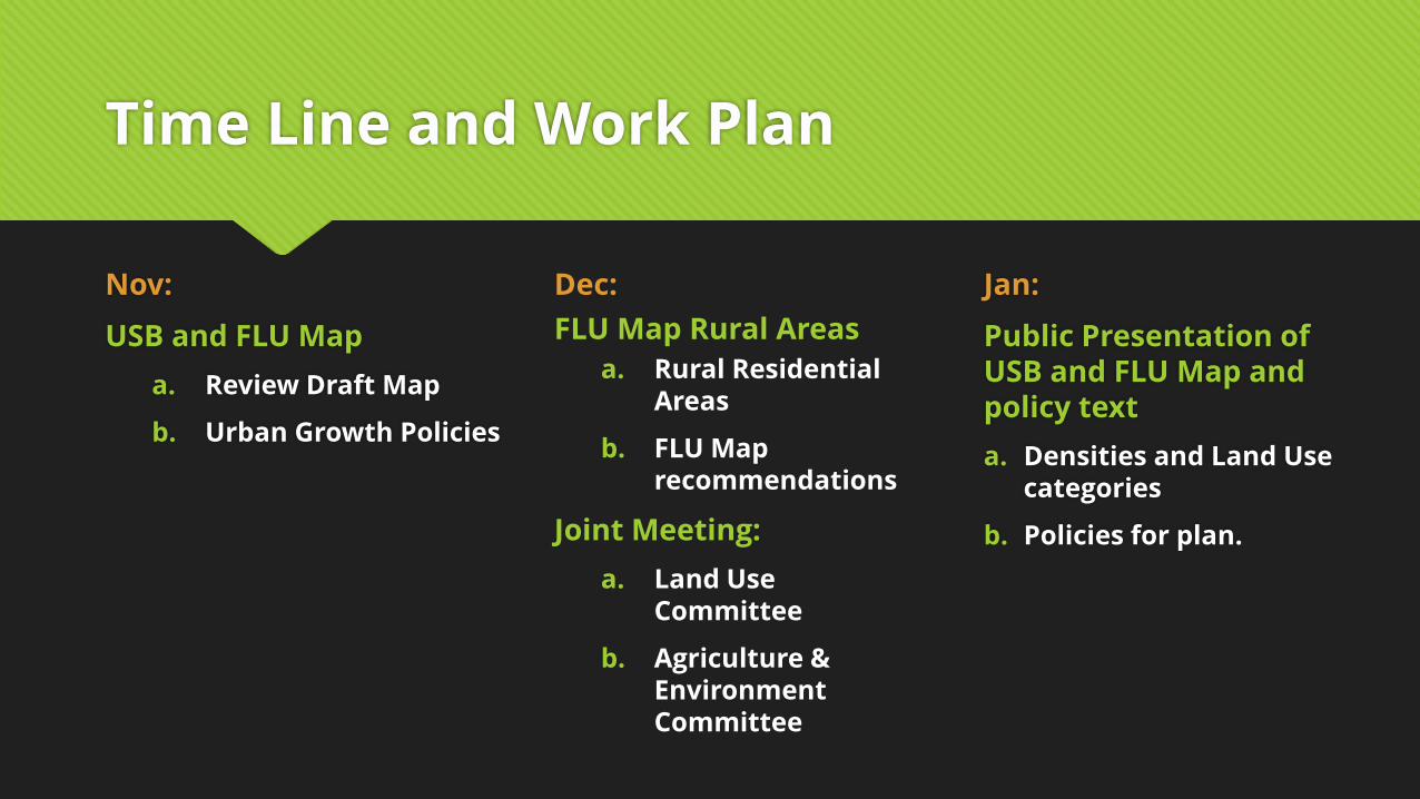
Time Line and Work Plan
Nov:
USB and FLU Map
a. Review Draft Map
b. Urban Growth Policies
Jan:
Public Presentation of USB and FLU Map and policy text
a. Densities and Land Use categories
b. Policies for plan.
Dec:
FLU Map Rural Areas
a. Rural Residential Areas
b. FLU Map recommendations
Joint Meeting:
a. Land Use Committee
b. Agriculture & Environment Committee

Rural Land Use Policy
Agricultural Uses, Rural Residential Uses, Conditional Use Permits,
Minimum Lot Size, and Building Standards

Unincorporated Area Statistics
Rural Parcel
Information
Average lot size:
17.22 acres
Median lot size:
4.91 acres
Parcel Size Percentage of
Unincorporated Land (Total 160,345.45 acres)
Percentage of Parcels(Total 9,223 parcels)
<10 acres
19,591.37 acres6,823 parcels
12.22 % 73.98 %
10-25 acres
15,629.63 acres1,003 parcels
9.75 % 10.87%
25.01-100 acres
51,025.46 acres997 parcels
31.82% 10.81%
100.01-250 acres
50,571.47 acres
342 parcels31.54% 3.71%
>250 acres
23,527.54 acres58 parcels
14.67% 0.63%

Unincorporated Area Statistics
Zone District Total
Acreage
Percent
A-1 154,672.29 97%
A-1S 9.94 0%
A-1R 92.55 0%
A-5 200.05 0%
B-1, B-2, B-3, (B-4),
B-5, (BP-1), (P-1A/B)134.49 0%
C-1 1,162.82 1%
Greenbelt 0.16 0%
R-1A, B, or C, R-2,
R-33,586.36 2%
I-1, I-2 214.96 0%
Future Land Use Total
Acreage
Percent
Agricultural 142,500.884 90%
Greenbelt 482.76 0.30%
Rural
Residential14,028.30 8.85%
Urban
Residential0.02 0%
Commercial 23.00 0.01%
Industrial 0 0%
Quasi-Public 1,403.46 0.89%

Agricultural & Rural Residential
Goals & Objectives
1. Preserve prime farmland for agricultural uses.
2. Provide access between and among rural areas, connections to regional transportation systems, and safe, economical mobility and accessibility for citizens and goods.
3. Provide an interconnected system of local and regional public open space and recreational opportunities.
4. Encourage sustainable development practices at site and community-wide levels.
5. Protect and enhance the natural, historic, and cultural landscapes that give Scott County its unique identity and image.
6. Highlight the special environmental qualities of Scott County in developed and undeveloped areas.
7. Promote enhanced use of the Elkhorn Creek as a resource for recreation and tourism, and a unique attraction for environmentally sensitive development within the Urban Service Boundary (USB).
10. Protect the natural environmental qualities of the creeks as special habitats for plants and animals, and make them accessible for educational purposes.
11. Increase access to local healthy foods and nutritional educational programs.
12. Protect water quality.
13. Protect creek conservation corridors.
14. Ensure the pristine water quality of the reservoir once it is constructed.
15. Protect the aquifer recharge area and county karst topography areas.
16. Minimize the amount of impervious coverage in rural areas.
17. Minimize the impact of waste produced in Scott County.
18. Promote clean air practices.
19. Protect environmentally sensitive areas.
20. Discourage development of areas with a concentration of sensitive resources or areas prone to health and safety hazards.
21. Require rezoning to conservation for any creek conservation corridors in any area proposed for development
22. Monitor the Environmentally Sensitive Areas ordinance for potential updates to sensitive areas and best management practices.
23. Support green spaces, parks & walkways.
24. Encourage agricultural economic growth in Scott County.
25. Work with agricultural advocacy groups to maintain and enhance the agricultural base.
26. Multiply markets for local agricultural products, and create market-driven agricultural diversification strategies.
27. Encourage cluster development when new major rural residential subdivisions are proposed.
28. Provide greater flexibility in land use regulations to adapt to shifting housing demands.

Agricultural Development Policy
GREEN: AGRICULTURAL AREAS
• Minimum Lot Size
• 10-acre minimum lot size should be considered to preserve prime farmland
• Neighboring counties to the south have more restrictive minimum lot sizes and
subdividing policies, putting pressure on Scott County prime farmland to develop
into residential property.
• An official study should be conducted to discover the best method for preserving
prime farmland in Scott County.
• Conditional Use Permits
• Limit all conditional uses to buildings 10,000 square feet or less.
• Remove:
• Slaughterhouses

Rural Residential Development Policy
LIGHT YELLOW: RURAL RESIDENTIAL AREAS
• Locations – where is rural residential appropriate?
• Rural residential should be located within a half-mile of the urban service boundary of
each city.
• Clustering reduces costs for emergency services
• Reduces costs for school transportation
• More efficient system of utilities (water, electric, internet)
• North-South Dividing line identified in previous Comprehensive Plans
• Buffer Requirements for A-5 zone district and/or minor subdivisions
• Buffering from cluster developments would remain the same
• Buffers for all other rural subdivisions would be:
• A single row of trees spaced 60 feet,
• Fencing as currently required,
• Would apply to major and minor subdivisions


FLU Map and USB
Public Review Process
Final Draft, Meeting Dates, and Appeal Deadlines

Timeline for FLU and USB Map Review
Jan. 12, 2017 Presentation of FLU and USB
Planning Commission meeting, 6pm at Scott County Courthouse
Jan. 26, 2017 Applications for inclusion/exclusion in the USB
Due at Planning Office by close of business, 4:30pm
FLU – no appeals to Future Land Use designations
USB – may apply for inclusion or exclusion in the USB only
If applying for inclusion in the USB, applicant will be required to provide a concept plan and narrative
to justify the FLU the applicant feels is most appropriate for the property
Cost: $75 (administrative appeals)
February 9, 2017 Review of USB Applications
Planning Commission meeting, 6pm at Scott County Courthouse

Updates to the Urban Area FLU
and Supplemental Maps
Base Map, Commercial Center Nodes, Gateways and Corridors,
Mobility Infrastructure, Parks and Recreation, and Community Facilities

Future Land Use Map
Base Map:
• Our “traditional” FLU Map
• Expanded to include both unincorporated areas and all cities
• Pair with Policy Guidance (Comp Plan text) and/or future small area studies to provide
recommendations on future development.
Supplemental Maps:
• Neighborhood Center “Nodes”
• Gateways and Corridors
• Mobility Infrastructure
• Parks and Recreation
• Community Facilities


Neighborhood Centers
Mixed Use Nodes
These nodes are scaled to fit the pedestrian shed at ¼ mile radius. This distance has been shown to be
the general distance an individual can comfortable walk in 5-10 minutes and a distance most people are
willing to walk to access transit or community uses.
• Mixed Used Commercial Retail/Office/Residential
• Higher density development
• Pedestrian-oriented development, parks, civic uses, trail and sidewalk linkages (density bonus)
Area 1: Downtown Georgetown
Area 2: West Georgetown
Area 3: Champion Way/Interchange 127
Area 4: Connector Road/Old Oxford Road
Area 5: Amerson Lemons Mill
Area 6: South Georgetown
Area 7: Sadieville
Area 8: Stamping Ground


Gateways & Corridors
This supplemental map addresses concerns raised over the way residents and visitors experience and
perceive our communities. Locations are prioritized for pedestrian and aesthetic improvements.
Blue: Major Community Corridors• Increased clean-up efforts
• Improved Sign Regulation Enforcement
Green: Priority Locations• Beautification efforts, such as trees, flowers, landscaping
• Develop more restrictive sign standards
• Potential for Form-Based Codes
Yellow: Gateways• New or improve welcome signs
• Seasonal flowers or landscaping


Mobility Infrastructure
This map includes proposed improvements to vehicular, bicycle, and pedestrian transportation
infrastructure.
Minor Projects: Existing Surfaces• Small upgrades to existing infrastructure
• Surface improvements,
• Restriping, paint, road diets, crosswalks
Major Projects: Expansion of Infrastructure• Large upgrades to existing infrastructure
• Road widening projects
• Adding new sidewalks, curb ramps,
• Grading work required
New Projects: Completely New Infrastructure• New roadways, trails, or connections
• Complete connections with new development
• Fund some projects with CIP and/or grants


Parks and Recreation
Existing (light line weight)and proposed (heavy line weight) parks and recreation areas are indicated on
this supplemental map.
Proposed parks and recreation facilities are either:
Linear: Trails, Paths, Etc.• Legacy Trail Project
• Connecting existing park facilities
• Mobility focused
• Recreation, but also transportation
• Sadieville includes horse trails, not just pedestrian or bicycle trails
Areas: General locations for More Traditional Parks• Proposed park in the Bradford neighborhood
• Corresponding to the Neighborhood Centers
• Northeast Georgetown


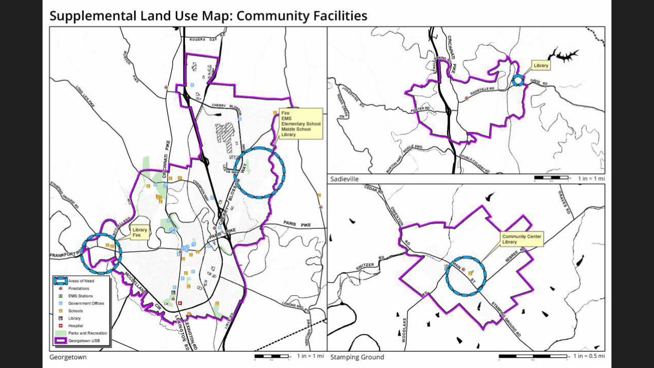
Community Facilities
Existing (solid)and proposed (dashed/hatched/shaded) Community Facilities areas are indicated on this
supplemental map.
Categories include:• Schools
• Libraries
• Fire Stations
• EMS Stations
• Hospital
• Government Offices
• Parks and Recreation
General locations are proposed for types of community facilities that are under-represented in those
areas of our community.

What happens next?
Next Sub-Committee Meeting
TBD, as needed
At-Home/On Your Schedule
Action Item Review
By each committee
Due Jan. 9, 2017
Check your emails!
FLU Map Dates
Jan. 12, 2017 Anticipated Release
at the Planning Commission
meeting, 6pm
Jan. 26, 2017 Appeal/Applications
to USB due at Planning Office by
close of business, 4:30pm
February 9, 2017 Hearing at
Planning Commission meeting,
6pm