landscape & visual sensitivity analysis · blunsdon parish council blunsdon east neighbourhood...
TRANSCRIPT

BSc (Hons) DipLA CMLI TechArborA ROB PILE Chartered Landscape Architect
1 Brassington Gardens, Withington, Cheltenham, Gloucestershire GL54 4DG
M: 07976 257010 T: 01242 890571 E: [email protected] www.connectedlandscapes.co.uk
BLUNSDON ST. ANDREW − EAST NEIGHBOURHOOD PLAN
LANDSCAPE & VISUAL SENSITIVITY ANALYSIS
ON BEHALF OF BLUNSDON PARISH COUNCIL
Blunsdon Parish Council
Blunsdon East Neighbourhood Plan
Landscape & Visual Sensitivity Analysis
December 2017 Page | 1
CONTENTS
1. INTRODUCTION ................................................................................... 2
2. METHODOLOGY .................................................................................... 4
3. IDENTIFICATION OF IMPORTANT VIEWS ................................................. 5
4. LANDSCAPE CHARACTER SENSITIVITY .................................................... 7
5. VISUAL SENSITIVITY .......................................................................... 17
6. SUMMARY .......................................................................................... 19
APPENDICES
APPENDIX 1: DETAILED METHODOLOGY
APPENDIX 2: BLUNSDON EAST NEIGHBOURHOOD PLAN AREA (17-003-002)
APPENDIX 3: VIEWPOINT LOCATION PLAN (CLS_010_04 VLP)
APPENDIX 4: LANDSCAPE CHARACTER AREAS (CLS_010_01 LCA)
APPENDIX 5: TOPOGRAPHY (CLS_010_03)
APPENDIX 6: ENVIRONMENTAL DESIGNATIONS AND LOCAL PLAN POLICIES
(CLS_010_02)
APPENDIX 7: VISUAL SENSITIVITY ANALYSIS PROFORMA
APPENDIX 8: PHOTOVIEWS AND DETAILED VISUAL SENSITIVITY ANALYSIS
(17-003-001)

Blunsdon Parish Council
Blunsdon East Neighbourhood Plan
Landscape & Visual Sensitivity Analysis
December 2017 Page | 2
1. INTRODUCTION
1.1 With the increasing need to accommodate growth and regeneration of settlements
whilst at the same time making those same settlements more sustainable, the
importance of countryside, landscapes and green spaces becomes ever greater.
Landscape and green space are at the heart of sustainable development,
contributing to the environmental dimension of the National Planning Policy
Framework (NPPF)1. They also form the setting for communities and the people
who define them, as set out in the European Landscape Convention (ELC)2.
1.2 Landscape is defined by the ELC thus:
“Landscape is an area, as perceived by people, whose character is
the result of the action and interaction of natural and/or human
factors.”
1.3 The Guidelines for Landscape and Visual Impact Assessment, 3rd Edition (GLVIA3)3
notes that it is not just ‘designated’ landscapes (National Parks, Areas of
Outstanding Natural Beauty etc.) that are important, but also the “ordinary and
the everyday – the landscapes where people live and work, and spend
their leisure time”.
1.4 GLVIA3 notes:
“When the interrelationship between people […] and the
landscape is considered, this introduces related but very different
considerations, notably the views that people have and their visual
amenity – meaning the overall pleasantness of the views they
enjoy of their surroundings.”
1.5 The distinction between landscape and visual amenity is an important one, though
the two are of course inextricably linked.
Purpose of this Report
1.6 As a result of the public consultation process, consideration is being given as to
whether there is potential for some carefully-sited, small-scale residential
development within and immediately surrounding the village of Blunsdon. The
public consultation process also indicated some concern that large-scale
development might result in adverse effects on the local landscape character and
on visual amenity as experienced from within the local area.
1 Department for Communities and Local Government, 2012 2 Council of Europe, 2004 3 Landscape Institute and Institute of Environmental Management & Assessment, 2013
Blunsdon Parish Council
Blunsdon East Neighbourhood Plan
Landscape & Visual Sensitivity Analysis
December 2017 Page | 3
1.7 Connected Landscapes, a landscape planning and landscape architecture practice,
was commissioned by Blunsdon Parish Council to undertake a visual sensitivity
analysis for a number of key views from within and around the village.

Blunsdon Parish Council
Blunsdon East Neighbourhood Plan
Landscape & Visual Sensitivity Analysis
December 2017 Page | 4
2. METHODOLOGY
2.1 This sensitivity analysis has been undertaken with regard to best practice, as
outlined in published guidance:
• Guidelines for Landscape and Visual Impact Assessment (3rd edition) -
Landscape Institute/ Institute of Environmental Management and Assessment
(2013)
• GLVIA3 Statement of Clarification 1/13 – Landscape Institute (2013)
• An Approach to Landscape Character Assessment – Natural England, October
2014
• Photography and photomontage in landscape and visual assessment (2011) -
Landscape Institute Advise Note 01/11
2.2 The detailed methodology is set out in Appendix 1.
2.3 The extent of the study area is shown at Appendix 2.
2.4 The analysis considers the sensitivity of the landscape and selected views to
residential development, though the same sensitivity may be equally relevant to
other forms of development.

Blunsdon Parish Council
Blunsdon East Neighbourhood Plan
Landscape & Visual Sensitivity Analysis
December 2017 Page | 5
3. IDENTIFICATION OF IMPORTANT VIEWS
3.1 The viewpoints and associated views which are considered in this report were
identified by members of the local community, through the Neighbourhood Plan
consultation process, as being “of merit and worthy of preservation”.
3.2 The Draft Neighbourhood plan contains two policies relating to landscape and
preservation of views. Both Policy 12 and Policy 5 are of relevance and the position
is summarised from Policy 12 which states:
“Landscape setting is an important part of this area, as the views
of the surrounding land are a significant input to its character
which reinforces the distinctive identity as a rural settlement on
land above the Thames plain. There are spectacular views both
from and into the village from many viewpoints. Northwards, there
are some exceptional panoramic views over the Thames valley
towards the Cotswolds, and back inwards towards the village.
Southwards, the views are blocked by new developments;
nevertheless, some open views of fields are visible and provide
some evidence of the settlement’s pastoral origins, helping to
depict its rural location. And there are good views from the public
footpath from Broadbush to the tributary of the Bydemill Brook.”4
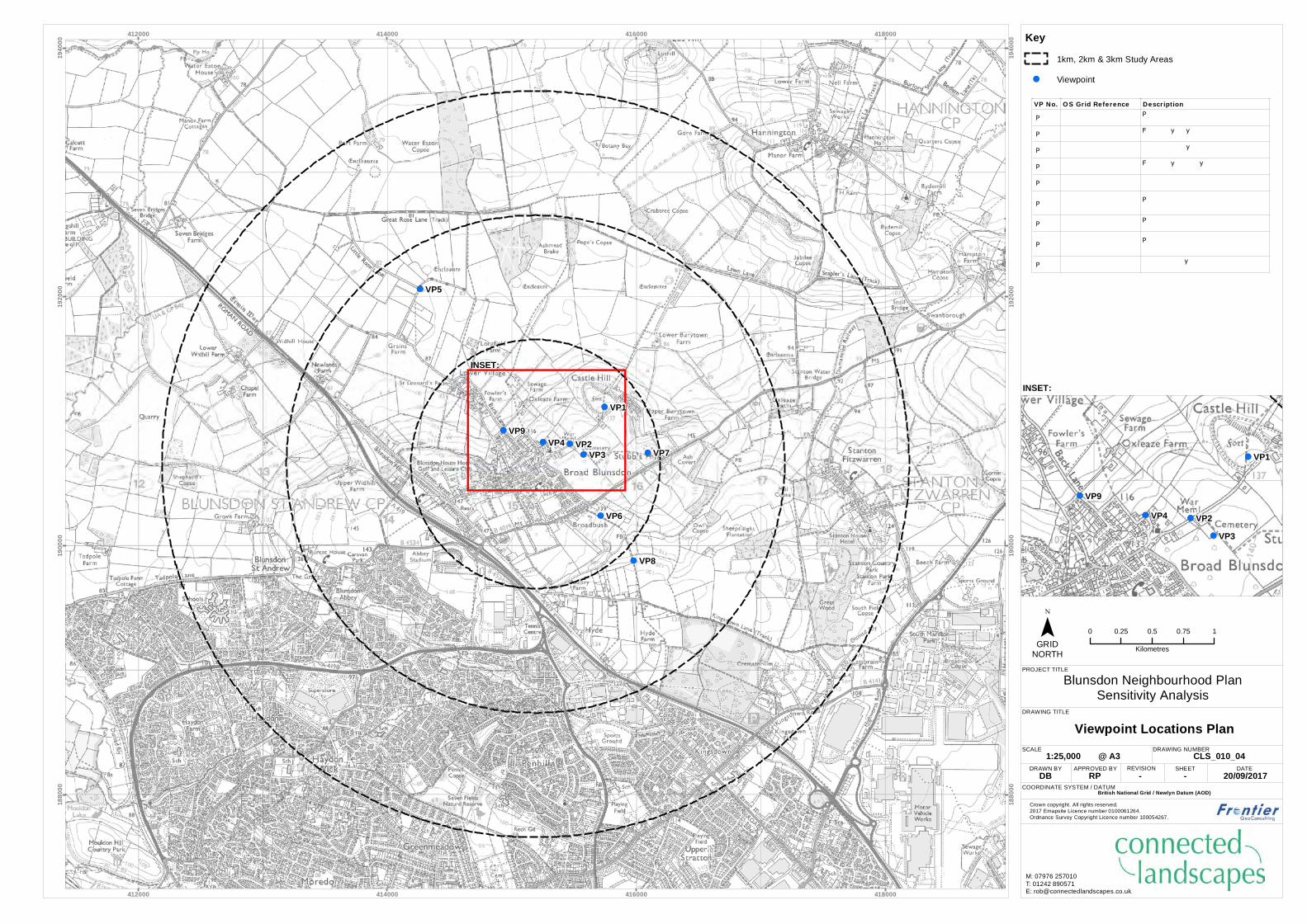
3.3 These views are shown on the Viewpoint Location Plan (see Appendix 3 and
Figure 3.1 below), and listed in Table 3.1:
Table 3.1: Sensitive Viewpoints
VP
No.
OS Grid
Reference
Description
VP1 SU 15745 91115 Public footpath crossing Castle Hill, looking north/north-west
VP2 SU 15467 90819 Field gateway on Burytown Lane, looking north-west
VP3 SU 15577 90733 Blunsdon Cemetery, looking south-east
VP4 SU 15250 90832 Field gateway on Churchway, looking north-west
VP5 SU 14264 92064 South-east end of Little Rose Lane, looking south-east
VP6 SU 15714 90242 Public footpath heading south-east from Broadbush, looking
south-east
VP7 SU 16093 90748 Public footpath on Stubb’s Hill, looking east and south
4 Sensitivity analysis briefing note/draft Neighbourhood Plan Policy 12, Blunsdon Parish Council, 2017

Blunsdon Parish Council
Blunsdon East Neighbourhood Plan
Landscape & Visual Sensitivity Analysis
December 2017 Page | 6
VP8 SU 15979 89880 Public footpath to north of Kingsdown Lane, looking north-
east
VP9 SU 14933 90926 Junction of Back Lane and Ivy Lane, looking north
Figure 3.1: Extract from Viewpoint Location Plan (Not to Scale)

Blunsdon Parish Council
Blunsdon East Neighbourhood Plan
Landscape & Visual Sensitivity Analysis
December 2017 Page | 7
4. LANDSCAPE CHARACTER SENSITIVITY
National (Landscape) Character Areas
4.1 National Landscape Character Areas (NCAs) were originally prepared by the former
Countryside Agency but are now managed by Natural England. Although they
typically cover quite large areas, these Character Assessments identify a number of
key landscape characteristics for each area. Broad Blunsdon is located at the
western end of NCA 109 – Midvale Ridge (see Appendix 4: Landscape Character
Areas), with this NCA extending in a relatively narrow north-east to south-west
aligned band. Broad Blunsdon is also very close to the boundary with NCA 108 –
Upper Thames Clay Vales, which surrounds NCA 109. Indeed, Lower Village lies
within NCA 108.
4.2 A full description of the Midvale Ridge NCA can be found at:
http://publications.naturalengland.org.uk/file/5792154
4.3 Key relevant characteristics of the Midvale Ridge NCA are described as:
• “Low, irregular wooded limestone ridge giving way to a series
of isolated steep-sided tabular hills in the east which rise from
the surrounding clay vales;
• Contrast between the moderately elevated limestone hills and
ridges and the surrounding low-lying clay vales;
• Drained mostly by small springs and streams which run into the
Thames, Thame and Ock;
• Well wooded – a third of the woodland is designated ancient
woodland;
• Mixed pastoral and arable landscape with large, geometric
fields divided by hedges and regularly spaced hedgerow trees
punctuated by blocks of woodland;
• …
• Evidence of previous land use such as iron-age and Romano-
British settlements and ridge and furrow through to old
quarries still visible in the landscape;
• …
• Settlement pattern of nucleated villages on the hill tops and
along the springline with low density of dispersed
settlement…”
4.4 Statements of Environmental Opportunities include SEO1:
Blunsdon Parish Council
Blunsdon East Neighbourhood Plan
Landscape & Visual Sensitivity Analysis
December 2017 Page | 8
“Maintain the historic environment and cultural character of the
Midvale Ridge by ensuring that permitted development is well
integrated to preserve local distinctiveness and sense of place and
providing green space and recreational opportunities for the health
and wellbeing of residents and visitors.”
4.5 The full description of the Upper Thames Clay Vales NCA can be found at:
http://publications.naturalengland.org.uk/file/6557755053703168
4.6 Key relevant characteristics of the Upper Thames Clay Vales NCA are described as:
• “Low-lying clay-based flood plains encircle the Midvale Ridge.
Superficial deposits, including alluvium and gravel terraces,
spread over 40 per cent of the area, creating gently undulating
topography. The Upper Jurassic and Cretaceous clays and the
wet valley bottoms give rise to enclosed pasture, contrasting
with the more settled, open, arable lands of the gravel;
• …
• Woodland cover is low at only about 3 per cent, but hedges,
hedgerow trees and field trees are frequent. Watercourses are
often marked by lines of willows and, particularly in the
Aylesbury Vale and Cotswold Water Park, native black poplar;
• …
• Wet ground conditions and heavy clay soils discourage
cultivation in many places, giving rise to livestock farming.
Fields are regular and hedged, except near the Cotswolds,
where there can be stone walls…
• …
• Settlement is sparse on flood plains, apart from at river
crossings, where there can be large towns, such as Abingdon.
Aylesbury and Bicester are major urban centres, and the outer
suburbs of Oxford and Swindon spread into this NCA. Market
towns and villages are strung along the springlines of the
Chilterns and Downs…”
4.7 Views to the north, east and south are generally across the Midvale Ridge NCA,
while those to the west are generally across the Upper Thames Clay Vales NCA.
However, the scale of the NCAs means that they are of limited value when
considering landscape character in relation to the setting of relatively small
settlements such as Blunsdon.

Blunsdon Parish Council
Blunsdon East Neighbourhood Plan
Landscape & Visual Sensitivity Analysis
December 2017 Page | 9
County Landscape Character Areas
4.8 At a county level, the 2005 Wiltshire Landscape Character Assessment places
Broad Blunsdon within Landscape Character Area (LCA) 8A: Swindon-Lyneham
Limestone Ridge, within Landscape Character Type (LCT) 8: Limestone Ridge. The
key characteristics of the LCT are described as:
• “Rolling upland landscape formed by a linear outcrop of
Stanford and Coral Rag Formation limestone;
• Level hill tops contrast with steep slopes down to the
surrounding clay lowland;
• Predominantly a pastoral landscape with some arable fields;
• Large fields with a network of hedgerow with numerous
hedgerow trees;
• Scattered tree clumps and woodland blocks, with some ancient
woodland;
• A settled landscape with a number of large villages, several
smaller settlements and scattered farmsteads;
• A variety of building styles from distinctive stone buildings in
historic village centres to modern development using a mix of
materials;
• Urban influences due to the proximity of Swindon and other
settlements, military complexes and the busy A3102 road;
• An intricate network of rural roads connects the villages and
farms;
• Panoramic views from higher ground, particularly from the
western scarp slopes.”
4.9 LCA 8A is described thus:
“The Swindon-Lyneham Limestone Ridge Character Area is a belt
of Coral Rag Formation limestone hills emerging from the lower
clay vales. The land form of the area undulates, rising sharply
along the western boundary to form a steep scarp slope in places.
To the east the transition to the lower clay areas is more gradual.
Land cover is predominantly pastoral farmland although there are
pockets of arable and horse pasture. The fields are fairly large and
divided by a network of hedgerows with numerous hedgerow trees
and intermittent woodland clumps, although the hedgerows have
become flailed and more open in places. Smaller, more sinuous

Blunsdon Parish Council
Blunsdon East Neighbourhood Plan
Landscape & Visual Sensitivity Analysis
December 2017 Page | 10
fields indicative of medieval enclosure are also present in more
isolated areas. Settlement has a considerable influence over the
area: the Swindon-Lyneham Limestone Ridge is divided into two
sections by the large urban mass of Swindon and other large
settlements also have a visual influence such as Highworth and
Purton, which are highly visible from surrounding lower areas. The
RAF airfield at Lyneham, dominates the southern central part of
the area. Smaller settlements have also been affected by urban
influences with ribbon development expansion and a proliferation
of signage along the more popular transport routes, such as the
A3102. Building materials and styles vary throughout, with local
stone buildings and more modern estates on the periphery. Within
the area views are intermittent, but from the peripheral slopes
there are panoramic views. Around Swindon the town dominates
but further south and in the very north of the area the views out
across the rural clay vales create a more remote feel.”
4.10 Inherent landscape sensitivities of the LCT are identified as:
• “Views to and from the lower surrounding clay vales;
• The areas of peaceful pastoral landscape;
• The hedgerow network and hedgerow trees;
• Scattered woodland blocks particularly the ancient woodlands
of high ecological value;
• Isolated areas of hay meadow and permanent pasture;
• The traditional structure of villages;
• The rural lanes.”
4.11 The landscape of the LCT is assessed as being of moderate overall condition, with
moderate strength of character.
4.12 Lower Village and land to the north-west of Broad Blunsdon lie within LCA 12A:
Thames Open Clay Vale, within LCT 12: Open Clay Vales. The relevant key
characteristics of the LCT are described as:
• “Level land form with wide open skies and views to ridges and
downs;
• Pastoral land use with some arable;
• Large scale geometric fields with hedgerows or open drainage
channels defining boundaries;

Blunsdon Parish Council
Blunsdon East Neighbourhood Plan
Landscape & Visual Sensitivity Analysis
December 2017 Page | 11
• Presence of rivers, tributaries, drainage channels and open
water bodies;
• Watercourses lined with riparian vegetation with prominent
lines of willows (some pollarded);
• Floristically rich hay meadows;
• Settlement pattern varies from large towns and small scattered
villages to sparse farmsteads;
• Buildings in varied materials of brick, render and stone;
• Crossed by major transport corridors, and a network of minor
roads linking settlements;
• Historic use for transport evident in canals.”
4.13 LCA 12A is described thus:
“Area 12A: Thames Open Clay Vale is a low lying area centred on
the River Thames and its floodplain. It is a largely tranquil, rural
landscape, predominantly level, with vertical elements of lines of
willow and other wetland trees. The agricultural use of the area
combines arable and wet pasture, with open water ditches as well
as hedgerows defining boundaries. Field patterns vary from small
and irregular to larger, geometric fields often in arable use on
dryer or drained gravel areas. A major feature of the area is the
large extent of open water resulting from gravel extraction and
afterwards put to leisure use as the Cotswold Water Park. The
many water bodies with their varied vegetation are of national
significance as scarce marl waters (Cotswold Water Park SSSI).
There are also a number of hay meadows of high ecological
interest. The presence of water is felt throughout this area in the
rivers, tributaries, drainage ditches with frequent lines of willows
and other wetland vegetation. Settlement is sparse in the Thames
Open Clay Vale with a few small settlements such as the village of
Ashton Keynes and the town of Cricklade, but mainly scattered
isolated farmsteads. Vernacular building materials are brick and
stone. Although the Roman Ermine Way, now the busy trunk road
of the A419, runs through the area, most of the roads are minor
rural routes with small bridges crossing the waterways and
ditches.”
4.14 Inherent landscape sensitivities of the LCT are identified as:
• “Rural tranquillity;

Blunsdon Parish Council
Blunsdon East Neighbourhood Plan
Landscape & Visual Sensitivity Analysis
December 2017 Page | 12
• Hedgerow pattern;
• Water bodies and water ways of varied character and ecological
value;
• Streamside willows and other riparian vegetation;
• Remnant hay meadows;
• Wide open views;
• Settlement pattern of nucleated villages with variety of
vernacular building materials.”
4.15 The landscape of the LCT is assessed as being of moderate overall condition, with
moderate strength of character.
District Landscape Character Areas
4.16 Broad Blunsdon lies within LCA vii: Mid Vale Ridge of the 2004 Swindon Borough
Council Landscape Character Areas Supplementary Planning Guidance, while Lower
Village lies within LCA i: Thames Vale, with the boundary between the two LCAs
lying along the north-western edge of Broad Blunsdon.
4.17 The Mid Vale Ridge LCA is described thus:
“The Midvale Ridge is characterised by two distinct areas, one to
the north-east and one to the south of Swindon. The southern
Midvale Ridge area comprises the area of land to the south of
Swindon that encompasses Coate Water and the open land to the
west of Coate Water and is bounded by the M4 motorway, the
eastern edge of Coate Water and Swindon’s settlement boundary.
The other Midvale Ridge Area contains the hilltop settlements of
Blunsdon, Hannington and Highworth, which run along the
Corallian Ridge. Included within the Corallian Ridge are the small
valley settlements of Stanton Fitzwarren, Sevenhampton and
South Marston. This Midvale Ridge area enjoys views over the
surrounding lower clay vales, particularly northwards over the
Thames Vale…”
4.18 Views across the Thames Vale towards the Cotswolds are particularly noted.
4.19 Development considerations are noted as:
• “Ensure that non-developed hilltops remain free from
development to preserve the prominence and quality of existing
hilltop settlements;

Blunsdon Parish Council
Blunsdon East Neighbourhood Plan
Landscape & Visual Sensitivity Analysis
December 2017 Page | 13
• Where opportunities arise, provide for additional tree planting
that maintains the scale and dispersed pattern of existing
woodlands;
• …
• Provide planting to contain the development within a discrete
area, reflecting the undulations of the landscape;
• Retain the perception of distinctiveness and separation from
Swindon within the Rural Buffer areas identified in the Local
Plan.”
4.20 The overall condition of the LCT is considered to be moderate, with moderate
strength of character. Of particular relevance to this sensitivity analysis are the
management objectives to:
• “Discourage intrusive development along the visually sensitive
ridgeline; and
• Limit further uncontrolled spreading of settlement and ribbon
development concentrating new development within existing
settlements.”
4.21 The Thames Vale LCA is described as:
“By definition, the Thames Vale comprises the alluvial plain
adjoining the river Thames. Water plays an important role in
forming this landscape, which includes a proliferation of ditches.
Willows are an important tree in the floodplain. In conjunction
with the existing hedgerows, there are occasional blocks of tree
planting, punctuating the landscape. Although development has
taken place within this area, it is dominated by a series of small
settlements with scattered, isolated groupings making up the
remainder.”
4.22 Extensive views across to the Midvale Ridge and Highworth are considered to be
particularly important.
4.23 Development considerations are noted as:
• “Ensure that the scale and massing of development does not
adversely affect the area’s perception of remoteness;
• Retain views and vistas to key local settlements and landmarks,
for example local churches (Lechlade);
Blunsdon Parish Council
Blunsdon East Neighbourhood Plan
Landscape & Visual Sensitivity Analysis
December 2017 Page | 14
• Where appropriate, provide planting that reinforces existing
hedgerows, compensating for the trees lost to Dutch Elm
disease during the 1970’s;
• Ensure that any woodland planting does not prejudice existing
vistas;
• Reflect the high visibility of this area from the Midvale Ridge;
• Where appropriate, restore former landscape features such as
meandering river channels, where these would benefit the
landscape and its wildlife.”
4.24 Published management objectives include:
• “Consider developing guidance for built development to ensure
both future construction and changes to existing buildings are
designed to integrate with the existing character and structure
of settlements; and
• Consider screening views to intrusive urban edges through
planting new woodland.
Author’s Own Assessment of Local Landscape Character
4.25 The published national, county and district landscape character assessments
provide a general impression of landscape character of the Application Site and the
surrounding area. A detailed assessment of the local landscape character shows:
Landscape Designations
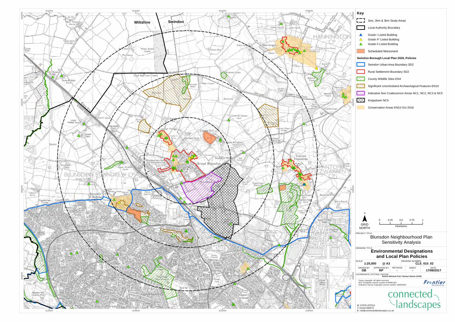
4.26 Broad Blunsdon and its environs are not covered by any landscape designations at
either the local or national level. The Cotswolds AONB lies approximately 13km to
the north of the village.
Landscape Scale
4.27 The agricultural fields surrounding Broad Blunsdon are generally medium-sized,
smaller closer to the settlement boundary and sometimes larger within the Thames
Vale. The landscape is of medium scale, though some views across the Vale create
the perception of a larger scale landscape
Landform and Enclosure
4.28 The landform around Broad Blunsdon falls into two distinct forms – the flatter
Thames Vale, and the rising/higher ground of the Mid Vale Ridge. This landform is
relatively uncomplicated.

Blunsdon Parish Council
Blunsdon East Neighbourhood Plan
Landscape & Visual Sensitivity Analysis
December 2017 Page | 15
4.29 Field boundary vegetation is generally strong, creating a strong sense of enclosure
within the areas of flatter topography, but with longer views still available where
the landform drops away to the Vale.
Landscape Pattern and Complexity
4.30 The fields around Broad Blunsdon are geometric in shape, with generally rectilinear
boundaries. The field boundaries are sometimes more sinuous where they relate to
watercourses such as the tributary of the Bydemill Brook which flows to the south
of the B4019. Their small to medium size results in a landscape pattern of
moderate complexity, with this complexity increased where built form and
infrastructure are more prominent.
Existing Built Infrastructure and Human Influence
4.31 The small hilltop village of Broad Blunsdon itself is the main area of built form
within the study area. The large and expanding conurbation of Swindon lies close
by, while the town of Highworth lies to the north-east, separated from Blunsdon by
approximately 4km. The A419 dual-carriageway and associated road junctions,
together with built form ranging from the Swindon greyhound track to isolated
farmsteads are further examples of the strong human influences in the area.
Within the Thames Vale, arable farming is a separate form of human influence.
4.32 Overall Broad Blunsdon and the surrounding area exhibit clear signs of long-term
and on-going human influence.
Settlement Pattern
4.33 The local settlement pattern comprises a mix of isolated farmsteads and houses,
smaller villages (such as Broad Blunsdon and Stanton Fitzwarren), larger villages
and towns (such as Highworth), and the large and expanding conurbation of
Swindon. This expansion has the potential to result in coalescence between
settlements, though local planning policy includes some measures to prevent this
from happening by designating certain areas as ‘non-coalescence areas’.
Skylines
4.34 Local skylines are varied. Where strong field boundary vegetation is present, this
can itself form the skyline to many views, while in longer views across the Thames
Vale the skyline is formed by the distant Cotswold Hills.
Inter-visibility
4.35 Levels of inter-visibility are variable, depending on topography and levels of
vegetation within the landscape. Rising ground of the Mid Vale Ridge allows long
distance views across the Thames Vale, yet from less undulating ground within the

Blunsdon Parish Council
Blunsdon East Neighbourhood Plan
Landscape & Visual Sensitivity Analysis
December 2017 Page | 16
Vale and elsewhere views can sometimes be limited by boundary vegetation to
within one or two fields.
Tranquillity
4.36 Tranquillity mapping undertaken by the Council for the Protection of Rural England
(CPRE)5 considered the local area to be of moderate tranquillity – less tranquil
within the main part of Broad Blunsdon and towards the A419, and more tranquil
in areas to the north and east with less built form and infrastructure (roads etc.).
Assessment of Landscape Character Sensitivity
4.37 The published county and, particularly, district level landscape character
assessments are considered to accurately reflect the character of the landscape
surrounding Broad Blunsdon and Lower Village. Views to and from the higher
ground where Broad Blunsdon is located are noted as being both important and
sensitive (see also Appendix 5: Topography).
4.38 The landscape is undesignated at either national/statutory or local/non-statutory
levels (see Appendix 6: Environmental Designations and Local Plan
Policies), but is nevertheless an attractive edge-of-settlement agricultural
landscape with strong field boundary vegetation. The latter results in sometimes
limited inter-visibility, though elsewhere the topography allows long views across
the Thames Vale. The local landscape is therefore considered to be of medium
value.
4.39 Outside of the main settlements, built form is generally sparse, limited to
farmsteads and occasional isolated residential properties. The balance between
built form and the more natural environment (albeit one that is heavily managed
through agriculture) which characterises the local landscape is of medium
susceptibility to small-scale, appropriately-sited residential development, but of
high susceptibility to large-scale development and/or development outside of the
existing settlement boundaries or on the rising slopes visible from the Thames
Vale. This results in an overall medium sensitivity to appropriately-located small-
scale development, but high sensitivity to large-scale development, especially any
which substantially extends or lies outside of the existing settlement boundary.
5 National Tranquillity Mapping Data 2007 developed for Campaign to Protect Rural England and Natural England by Northumbria University. OS Licence number 100018881.

Blunsdon Parish Council
Blunsdon East Neighbourhood Plan
Landscape & Visual Sensitivity Analysis
December 2017 Page | 17
5. VISUAL SENSITIVITY
5.1 All visual receptors are people. Visual sensitivity is therefore a combination of the
susceptibility of a person or group of people at a specific viewpoint to changes in
that view (which may in turn depend on the type of change experienced), and the
value attached to that view.
5.2 Susceptibility is mainly a function of the occupation or activity of people
experiencing the view at particular locations, and the extent to which their
attention or interest is focussed (or otherwise) on the view. This is explained
further in the detailed methodology in Appendix 1, but for the purposes of this
analysis the most sensitive receptors are likely to include:
• occupants of residential properties (especially those with rural views);
• users of Public Rights of Way (PRoWs) whose focus and attention is likely to
be on the surrounding landscape; and
• visitors to particular locations where the views of the landscape are a
component of most visitors’ enjoyment of the location.
5.3 At the other end of the spectrum, receptors likely to be least sensitive to changes
in the view include:
• those travelling on main roads and motorways; and
• people at their place of work whose attention is not focussed on their
surroundings.
Assessment Process
5.4 The “important views” identified through the Neighbourhood Plan consultation
process were visited during September 2017.
5.5 Panoramic photographs were taken from each viewpoint using a full-frame DSLR
fitted with a 50mm lens and mounted on a levelled panoramic tripod. The
panoramic photos were taken with an arc of view of approximately 75, 145 or 215
degrees (depending on the view available from each viewpoint).
5.6 To ensure consistency of analysis, a proforma was completed at each viewpoint,
recording a range of criteria for each view (see Appendix 7):
• topography and skylines;
• landscape scale;
• landscape pattern and complexity;
• aesthetic and perceptual quality; and
• views, visual character and inter-visibility.

Blunsdon Parish Council
Blunsdon East Neighbourhood Plan
Landscape & Visual Sensitivity Analysis
December 2017 Page | 18
5.7 Information recorded on the proforma was then combined with professional
judgement and an analysis of the panoramic photos to assess the sensitivity of
each of the views to residential development.
Assessment of Visual Sensitivity
5.8 The photoviews and detailed analysis of visual sensitivity are provided at
Appendix 8, and summarised in Table 5.1 below:
Table 5.1: Summary Visual Sensitivity of Important Views
VP
No.
Receptor Type View into
or out of
the village
Value of
the View
Susceptibility
of Receptors
Sensitivity
VP1 PRoW users Out of village Medium High High
Residential
occupiers
Medium High High
VP2 Minor road users Out of village Medium Medium Medium
Cemetery
visitors
Medium Medium Medium
VP3 Cemetery
visitors
Out of village Medium Medium Medium
VP4 Minor road users Out of village Medium Medium Medium
Residential
occupiers
Medium High High
VP5 Minor road users Into village Medium Medium Medium
VP6 PRoW users Out of village Medium High High
Residential
occupiers
Medium High High
VP7 PRoW users Out of village Medium High High
VP8 PRoW users Into village Medium High High
VP9 Minor road users Out of village Medium Medium Medium
Residential
occupiers
Medium High High
5.9 The majority (six of nine) of the important views have been assessed as being of
high sensitivity, with the remaining three assessed as being of medium sensitivity.
Blunsdon Parish Council
Blunsdon East Neighbourhood Plan
Landscape & Visual Sensitivity Analysis
December 2017 Page | 19
6. SUMMARY
6.1 As part of the preparation of a Neighbourhood Plan, Blunsdon Parish Council
commissioned Connected Landscapes to undertake a landscape and visual
sensitivity analysis for the village and surrounding landscape.
6.2 The landscape which surrounds the hilltop village is undesignated at either
national/statutory or local/non-statutory levels, but is nevertheless an attractive
edge-of-settlement agricultural landscape with strong field boundary vegetation.
The latter results in sometimes limited inter-visibility, though elsewhere the
topography allows long views across the Thames Vale. Outside of the main
settlements, and particularly on the sloping ground that drops away from the
village, built form is generally sparse, limited to farmsteads and occasional isolated
residential properties.
6.3 The balance between built form and the more natural environment (albeit one that
is heavily managed through agriculture) which characterises the local landscape is
assessed as being of medium sensitivity to appropriately-located small-scale
development, but high sensitivity to large-scale development, especially any which
substantially extends or lies outside of the existing settlement boundary.
6.4 As part of the neighbourhood plan consultation process, nine ‘important views’
were identified in the landscape surrounding the village that are considered “of
merit and worthy of preservation” because they provide the undeveloped
setting to the hilltop village. These views have been assessed for their visual
sensitivity, having been recognised, both by the Parish Council and in published
landscape character assessments, as being both important and potentially
sensitive.
6.5 Six of the nine views are assessed as being of high sensitivity to residential
development, with the remaining three views considered to be of medium
sensitivity.

December 2017
APPENDIX 1:
DETAILED METHODOLOGY
Introduction
1.1 This assessment has been undertaken with regard to best practice, as outlined in
published guidance:
• Guidelines for Landscape and Visual Impact Assessment (3rd edition) -
Landscape Institute/ Institute of Environmental Management and Assessment
(2013)
• GLVIA3 Statement of Clarification 1/13 – Landscape Institute (2013)
• An Approach to Landscape Character Assessment – Natural England, October
2014
• Photography and photomontage in landscape and visual assessment (2011) -
Landscape Institute Advise Note 01/11
1.2 The field survey work was undertaken in September 2017 when tree and hedgerow
vegetation was generally still in leaf. Consideration has also therefore been given
to the potential for greater visibility of the during the winter months when
deciduous vegetation is not in leaf.
Landscape Character Sensitivity Methodology
1.3 The landscape character analysis considers landscape character and landscape
value. The analysis identifies landscape receptors, and assesses the sensitivity of
them.
1.4 The susceptibility of landscape character is an expression of the landscape’s ability
to accommodate change. It varies depending on factors such as the existing land
use, pattern and scale of the landscape, the degree of openness, condition, the
value placed on the landscape and any designations that may apply. In most cases
the landscape components in the immediate surroundings strongly influence the
landscape character more so than distant elements or features. However, at
elevated viewpoints it is possible to feel a sense of exposure or remoteness due to
the absence of nearby features.
1.5 Landscape value is considered in terms of factors such as the condition and quality
of the landscape, the scenic quality, the rarity of the landscape in the locality and
at a larger scale, the representativeness of the landscape, the recreation or
amenity value of the landscape, its perceptual aspects such as wildness or
tranquillity, and any associations that may exist between the local landscape and
historical people or events. This list is not necessarily exhaustive or definitive.
(GLVIA3, page 84).
1.6 Sensitivity of landscape character is determined by a combination of the value that
is attached to a landscape and the susceptibility of the landscape character to
change – see Pages 88-90 of GLVIA3. Both value and susceptibility are assessed as
high, medium or low.

December 2017
Table 1: Sensitivity of Landscape Character
Value
Susceptibility
High Medium Low
High High High Medium
Medium High Medium Low
Low Medium Low Low
Table 2: Criteria for Landscape Character Value
Criteria
High Designated areas at an International, Regional or National (including but not limited
to World Heritage Sites, National Parks, AONBs etc.) and also considered an
important component of the country’s character, experienced by a high number of
people.
Landscape condition is good and components are generally maintained to a high
standard.
In terms of seclusion, enclosure by land use, traffic and movement, light pollution
and presence/absence of major infrastructure, the landscape has an elevated level
of tranquillity.
Rare or distinctive elements and features are key components that contribute to the
character of the area.
Medium Local or district-level formal designation (SLA etc.), or (typically) rural landscapes
important to the setting of villages etc. and also considered to a distinctive
component of the regional/county character experienced by a large proportion of its
population. May also include larger public open spaces such as parks or key green
infrastructure elements within urban areas.
Landscape condition is fair and components are generally well maintained.
In terms of seclusion, enclosure by land use, traffic and movement, light pollution
and presence/absence of major infrastructure, the landscape has a moderate level
of tranquillity.
Rare or distinctive elements and features are notable components that contribute to
the character of the area.
Low No formal designations but a landscape of local relevance. Also green infrastructure
and smaller open spaces within residential/urban areas likely to be visited and
valued by the local community.
Landscape condition may be poor and components poorly maintained or damaged.
In terms of seclusion, enclosure by land use, traffic and movement, light pollution
and presence/absence of major infrastructure, the landscape has limited levels of
tranquillity.
Rare or distinctive elements and features are not notable components that
contribute to the character of the area.

December 2017
Table 3: Criteria for Landscape Susceptibility
Criteria
High Scale of enclosure – landscapes with a low capacity to accommodate the type of
development proposed owing to the interactions of topography, vegetation cover,
built form etc.
Nature of land use – landscapes with no or little existing reference or context to the
type of development being proposed.
Nature of existing elements – landscapes with components that are not easily
replaced or substituted (e.g. ancient woodland, mature trees, historic parkland
etc.).
Nature of existing features – landscapes where detracting features or major
infrastructure is not present or where present has limited influence on the
landscape.
Medium Scale of enclosure – landscapes with a medium capacity to accommodate the type
of development proposed owing to the interactions of topography, vegetation cover,
built form etc.
Low Nature of land use – landscapes with some existing reference or context to the type
of development being proposed.
Visual Sensitivity Methodology
1.7 The sensitivity of receptor groups depends on factors such as duration of view, the
angle at which they would see the Application Site and the nature of the viewer
e.g. resident, tourist or worker. In general, residential receptors, tourists,
recreational users of public rights of way and views from recognised vantage points
are considered to have a higher sensitivity to change than people travelling along
highways or at places of work.
1.8 Sensitivity is determined by a combination of the value that is attached to a view
and the susceptibility of the receptor to changes in that view – see Pages 113-114
of GLVIA3. Both value and susceptibility are assessed as high, medium or low.
1.9 The value attached to a view includes a recognition of value through formal
designations (for example landscape designations), and indicators of value
attached to views by visitors (for example inclusion on maps or within guidebooks,
provision of facilities, presence of interpretation etc.).

December 2017
Table 4: Criteria for Assessing the Value of Views
Criteria
High Views with high scenic value within nationally-designated landscapes including but
not limited to World Heritage Sites, National Parks, Areas of Outstanding Natural
Beauty, etc. Likely to include key viewpoints on OS maps or reference within
guidebooks, provision of facilities, presence of interpretation boards, etc.
Medium Views with moderate scenic value within undesignated landscapes or those falling
under local (non-statutory) designations, including urban fringe and rural
countryside.
Low Views with unremarkable scenic value within undesignated landscape with partly
degraded visual quality and detractors.
Table 5: Criteria for Susceptibility for Visual Receptors
Criteria
High Includes occupiers of residential properties and people engaged in recreational
activities in the countryside such as using Public Rights of Way.
Medium Includes people engaged in outdoor sporting activities and people travelling through
the landscape on minor roads and trains.
Low Includes people at place of work e.g. industrial and commercial premises and people
travelling through the landscape on A roads and motorways.
Table 6: Sensitivity of Visual Receptors
Value
Susceptibility
High Medium Low
High High High Medium
Medium High Medium Low
Low Medium Low Low
1.10 The viewpoints identified through the consultation process were visited and
photographs taken using a digital SLR (Canon EOS 6D) fitted with a 50mm focal
length lens and mounted on a levelled tripod with a panoramic head. Viewpoint
locations have been recorded using a Garmin 64s hand-held GPS.
1.11 All of the representative viewpoints have been taken at 1.6m above ground level.
However, where relevant, assumed views from the upper floors of buildings have
also been considered. Viewpoints include, where relevant, residential properties,
highways, public footpaths, bridleways, recreation and places of work. The baseline
data for the viewpoints includes:
• Location of viewpoint;
• Nature of visual receptor;

December 2017
• Description of the existing view from each viewpoint; and
• Sensitivity of visual receptor.
1.12 A proforma was completed at each viewpoint to ensure that the analysis was
undertaken in a consistent manner for each viewpoint – see Appendix 7.

December 2017
APPENDIX 2:
BLUNSDON EAST NEIGHBOURHOOD PLAN AREA

Client
Project
Drawing Title
Scale Date
Drawn by
Drawing No.
Checked by
M: 07976 257010T: 01242 890571E: [email protected]
Rev
Blunsdon East Parish Council
Blunsdon Neighbourhood PlanSensitivity Analysis
Study Area
1:25,000 @ A4 30/11/2017
RP IJ
17-003-002
KEY:
EXTENT OF STUDY AREA

December 2017
APPENDIX 3:
VIEWPOINT LOCATION PLAN
!(
!(
!(
!(
!(
!(
!(
!(
!(
VP1
VP2VP3
VP4
VP5
VP6
VP7
VP8
VP9
412000
412000
414000
414000
416000
416000
418000
418000
1880
00
1880
00
1900
00
1900
00
1920
00
1920
00
1940
00
1940
00
GRIDNORTH
0 0.25 0.5 0.75 1
Kilometres
Blunsdon Neighbourhood PlanSensitivity Analysis
@ A3
DRAWING TITLE
PROJECT TITLE
SCALE 1:25,000
Key1km, 2km & 3km Study Areas
!( Viewpoint
COORDINATE SYSTEM / DATUMBritish National Grid / Newlyn Datum (AOD)
DATE20/09/2017DRAWN BYDB APPROVED BYRPREVISION
- SHEET-CLS_010_04DRAWING NUMBER
Crown copyright. All rights reserved.
2017 Emapsite Licence number 0100061264.
Ordnance Survey Copyright Licence number 100054267.
Viewpoint Locations Plan
M: 07976 257010
T: 01242 890571E: [email protected]
!(
!(
!(
!(
!(
VP1
VP2VP3
VP4VP9
INSET:
INSET:
VP No. OS Grid Reference DescriptionVP1 SU 15745 91115 Public footpath cros sing Cas tle Hill,
looking north/north-w e s tVP2 SU 15467 90819 Fie ld gate w ay on Burytow n Lane ,
looking north-w e s tVP3 SU 15577 90733 Blunsdon Ce me te ry, looking south-
e as tVP4 SU 15250 90832 Fie ld gate w ay on Churchw ay,
looking north-w e s tVP5 SU 14264 92064 South-e as t e nd of Little Ros e Lane ,
looking south-e as t
VP6 SU 15714 90242 Public footpath he ading south-e as t from Broadbush, looking south-e as t
VP7 SU 16093 90748 Public footpath on Stubb’s Hill, looking e as t and south
VP8 SU 15979 89880 Public footpath to north of Kingsdow n Lane , looking north-e as t
VP9 SU 14933 90926 Junction of Back Lane and Ivy Lane , looking north

December 2017
APPENDIX 4:
LANDSCAPE CHARACTER AREAS

SS
S
Midvale RidgeUpper ThamesClay Vales
SwindonWiltshire
S
i.
vii.
i.
08A
12A
12A
11B11A
2
1
3 3
412000
412000
414000
414000
416000
416000
418000
418000
1880
00
1880
00
1900
00
1900
00
1920
00
1920
00
1940
00
1940
00
GRIDNORTH
0 0.25 0.5 0.75 1
Kilometres
Blunsdon Neighbourhood PlanSensitivity Analysis
@ A3
DRAWING TITLE
PROJECT TITLE
SCALE 1:25,000
Key1km, 2km & 3km Study Areas
National Character Areas
Local Authority Boundary
Wiltshire Landscape Character Assessment (2005)Landscape Character Areas
North Wiltshire Landscape Character Assessment (2004)Landscape Character Areas
01: Thames Valley Floor
02: Thames Valley Lowland
03: Swindon Fringe
Swindon Borough Council Landscape Character Areas (2004)Landscape Character Areas
S. Settlement
i. Thames Vale
vii. Mid Vale Ridge
COORDINATE SYSTEM / DATUMBritish National Grid / Newlyn Datum (AOD)
DATE17/09/2017DRAWN BYDB APPROVED BYRPREVISION
- SHEET-CLS_010_01DRAWING NUMBER
Crown copyright. All rights reserved.
2017 Emapsite Licence number 0100061264.
Ordnance Survey Copyright Licence number 100054267.
Landscape Character Areas
M: 07976 257010
T: 01242 890571E: [email protected]

December 2017
APPENDIX 5:
TOPOGRAPHY

140
115110
105
100
95
130
125
85
8012
5 120 11
5 110
100
110105
90100
95
130
115
125
120
110
105
110
10
5
100
95
90
95
90
100
95
90
85
9085
80
150
145
115110
90
85
90
85
85
80
135120
105
95
105
100
100
80
100
100
90
100
90
80
150
14
5
125
125
125
120
125
115
120
115
110
110
110
110
105
110
110
10
5
105
105
100
100
100
90
95
95
90
90
85
85
85
85
80 85
85
80
80
80
80
120
90
90
90
80
80
412000
412000
414000
414000
416000
416000
418000
418000
1880
00
1880
00
1900
00
1900
00
1920
00
1920
00
1940
00
1940
00
GRIDNORTH
0 0.25 0.5 0.75 1
Kilometres
Blunsdon Neighbourhood PlanSensitivity Analysis
@ A3
DRAWING TITLE
PROJECT TITLE
SCALE 1:25,000
Key1km, 2km & 3km Study Areas
5m Contour
DTM (metres above ordnance datum)High : 152.958
Low : 73.2263
COORDINATE SYSTEM / DATUMBritish National Grid / Newlyn Datum (AOD)
DATE17/09/2017DRAWN BYDB APPROVED BYRPREVISION
- SHEET-CLS_010_03DRAWING NUMBER
Crown copyright. All rights reserved.
2017 Emapsite Licence number 0100061264.
Ordnance Survey Copyright Licence number 100054267.
Topography Plan
M: 07976 257010
T: 01242 890571E: [email protected]
December 2017
APPENDIX 6:
ENVIRONMENTAL DESIGNATIONS
AND LOCAL PLAN POLICIES
##
########
#
####
# #
#
###########
#############
#####
#
#
#
###########
#
#
#
##
##
#
#
#
#
#
#
#
##
#
###
#
#
#
#
#
####
##
#
#
###
#
##
###
##
#
##
#
#################
#
####
#
####
#
###
####
##
#
#
##
#
#
#
#
##
#
#
#
#
#
#
#
#
###
#
#
########
###
#
######### ###
#
# ######
#
#
#
#
#
#
#
###
#
###
##
#### ###
#
#
#
###
#
##
##
#
#
###########
#
#
#
#
#
#
#
#
#
#
#
#
#
###
##
#
###
#
###
##
########
#
#
#####
#
#
#
###
#
#
#
#
#
#
#
#
#
#
#
##
#
#
#
##
####
#
#
#
#
#
#
##
#
###
##
###
#
#
#
##
#
#
#
#
#
#
#
#
# ###
#
##
##
##
#
#
#
#
##
#
#
#
###
#
##
#
#
###
#
#
##
#
#
#
##
#
#
#
### #
#
#
#
#
##
#
##
###
#
####
##
#
#
##
##
#
#
#
#
## ##
#
#
##
#
#
# ###
#
#
#
#####
#
#
#
#
###
#
###
#
#
##
#######
#
# #
#
#
#
#
###
#
#
#
#
#
#
#
# #
######
#####
##
#####
##
#
#
### #
#
#
#
##
#
#
# ##
#
##
#
#
#
#
#
#
#
**
********
*
****
* *
*
***********
*************
*****
*
*
*
***********
*
*
*
**
**
*
*
*
*
*
*
*
**
*
***
*
*
*
*
*
****
**
*
*
***
*
**
***
**
*
**
*
*****************
*
****
*
****
*
***
****
**
*
*
**
*
*
*
*
**
*
*
*
*
*
*
*
*
***
*
*
********
***
*
********* ***
*
* ******
*
*
*
*
*
*
*
***
*
***
**
**** ***
*
*
*
***
*
**
**
*
*
***********
*
*
*
*
*
*
*
*
*
*
*
*
*
***
**
*
***
*
***
**
********
*
*
*****
*
*
*
***
*
*
*
*
*
*
*
*
*
*
*
**
*
*
*
**
****
*
*
*
*
*
*
**
*
***
**
***
*
*
*
**
*
*
*
*
*
*
*
*
* ***
*
**
**
**
*
*
*
*
**
*
*
*
***
*
**
*
*
***
*
*
**
*
*
*
**
*
*
*
*** *
*
*
*
*
**
*
**
***
*
****
**
*
*
**
**
*
*
*
*
** **
*
*
**
*
*
* ***
*
*
*
*****
*
*
*
*
***
*
***
*
*
**
*******
*
* *
*
*
*
*
***
*
*
*
*
*
*
*
* *
******
*****
**
*****
**
*
*
*** *
*
*
*
**
*
*
* **
*
**
*
*
*
*
*
*
*
#
#
#
#####
#
#
#
#
#
#
##
##
#
#
#
#
#
#
#
#
*
*
*
*****
*
*
*
*
*
*
**
**
*
*
*
*
*
*
*
*
¹
¹
¹
¹
¹
¹
¹¹
¹
¹
¹
¹
¹
*
*
*
*
*
*
**
*
*
*
*
*
SwindonWiltshire
412000
412000
414000
414000
416000
416000
418000
418000
1880
00
1880
00
1900
00
1900
00
1920
00
1920
00
1940
00
1940
00
GRIDNORTH
0 0.25 0.5 0.75 1
Kilometres
Blunsdon Neighbourhood PlanSensitivity Analysis
@ A3
DRAWING TITLE
PROJECT TITLE
SCALE 1:25,000
Key1km, 2km & 3km Study Areas
Local Authority Boundary
¹* Grade I Listed Building
#* Grade II* Listed Building
#* Grade II Listed Building
Scheduled Monument
Swindon Borough Local Plan 2026, PoliciesSwindon Urban Area Boundary SD2
Rural Settlement Boundary SD2
County Wildlife Sites EN4
Significant Unscheduled Archaeological Features EN10
Indicative Non Coalescence Areas NC1, NC2, NC3 & NC5
Kingsdown NC5
Conservation Areas EN10 Oct 2016
COORDINATE SYSTEM / DATUMBritish National Grid / Newlyn Datum (AOD)
DATE17/09/2017DRAWN BYDB APPROVED BYRPREVISION
- SHEET-CLS_010_02DRAWING NUMBER
Crown copyright. All rights reserved.
2017 Emapsite Licence number 0100061264.
Ordnance Survey Copyright Licence number 100054267.
Environmental Designationsand Local Plan Policies
M: 07976 257010
T: 01242 890571E: [email protected]

December 2017
APPENDIX 7:
VISUAL SENSITIVITY ANALYSIS PROFORMA

Landscape and Visual Sensitivity Study
Field Survey - Sensitivity
1
LOCATION:
Criterion Description
Topography and skylines
Landscape scale (landform and component landscape features)
Landscape pattern and complexity (including sense of time-depth)
Aesthetic and perceptual quality (including landscape experience and tranquility)
Views, visual character and inter-visibility

Landscape and Visual Sensitivity Study
Field Survey - Sensitivity
2
Notes
Aesthetic: scale, enclosure, diversity, texture, form, line, colour, balance, movement, pattern
Perceptual/experiential: security, stimuli, tranquility, movement, naturalness, noise

December 2017
APPENDIX 8:
PHOTOVIEWS AND
DETAILED VISUAL SENSITIVITY ANALYSIS

Project Title: Blunsdon East Neighbourhood Plan - Visual Sensitivity Analysis
PROJECT INFORMATION
Drawing Tile: Visual Sensitivity
Drawn By: RP
Dwg. No: 17-003-001
Approved By: IJ
Sheet No: 1 of 17
Date: 29/09/2017 Rev:
Produced By:
VIEWPOINT 1APublic footpath crossing Scheduled Monument at Castle Hill,
looking north-west
© Crown copyright, All rights reserved. 2017 emapsite Licence number 0100031673
Camera make & model - Canon 6D with 50mm lens
VIEWPOINT INFORMATION
Date & time of photograph - 18/09/2017 @ 10:42
OS grid reference - SU 15745 91115
Viewpoint height (AOD) - 135m
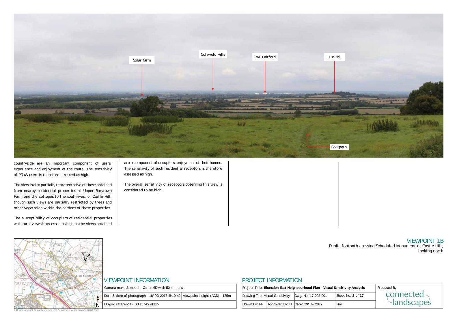
Description of View
The view is across an area of rough pasture and nettles
(which covers the Scheduled Monument site) in the
foreground, and then across the Thames Vale towards
the Cotswold Hills in the distance. The distant skyline is
formed by the Cotswold Hills, though some closer skylines
are formed by trees and tall hedgerows.
The topography falls away from the viewpoint, becoming
very gently undulating within the Thames Vale, with
occasional more defined hills such as Luss Hill. In the distance the landform rises again to the Cotswold Hills.
This is a medium-scale agricultural landscape with strong
field boundary vegetation, and often irregular field shapes. The landscape is generally of moderate complexity,
including elements of built form such as the large, light-
coloured buildings at RAF Fairford, and a solar farm. The
settlement of Cricklade is partially visible to the west,
while other smaller settlements such as Castle Eaton and
Kempsford are also partially visible. Overall, tree cover
means that built form appears relatively infrequently in
the view, though the agricultural landscape is still clearly
a managed one.
The landscape is relatively tranquil, with traffic movement generally hidden from view by intervening vegetation.
Depending on the wind direction there can sometimes be
limited background noise from traffic on the A419.
From Castle Hill, the rising topography allows very long
views and high levels of inter-visibility across the Thames
Vale. From the lower ground of the Vale, views within the
Vale are often more limited due to strong field boundary vegetation, though the rising ground of the Mid-Vale
Ridge is generally visible from the Vale.
Sensitivity
The view from this location is considered to be of medium
value as it is of not unattractive but undesignated
farmland, albeit with some visible human influences such as RAF Fairford and the solar farm. The nationally-
designated Cotswold AONB is visible in the far distance,
but views from the AONB are unlikely to be notably
affected by potential development in the vicinity of Blunsdown.
The susceptibility of users of Public Rights of Way (PRoWs)
is considered to be high as views of the surrounding
N
CrickladeCotswold Hills
Project Title: Blunsdon East Neighbourhood Plan - Visual Sensitivity Analysis
PROJECT INFORMATION
Drawing Tile: Visual Sensitivity
Drawn By: RP
Dwg. No: 17-003-001
Approved By: IJ
Sheet No: 2 of 17
Date: 29/09/2017 Rev:
Produced By:
VIEWPOINT 1BPublic footpath crossing Scheduled Monument at Castle Hill,
looking north
© Crown copyright, All rights reserved. 2017 emapsite Licence number 0100031673
Camera make & model - Canon 6D with 50mm lens
VIEWPOINT INFORMATION
Date & time of photograph - 18/09/2017 @ 10:42
OS grid reference - SU 15745 91115
Viewpoint height (AOD) - 135m
countryside are an important component of users’
experience and enjoyment of the route. The sensitivity
of PRoW users is therefore assessed as high.
The view is also partially representative of those obtained
from nearby residential properties at Upper Burytown
Farm and the cottages to the south-west of Castle Hill,
though such views are partially restricted by trees and
other vegetation within the gardens of those properties.
The susceptibility of occupiers of residential properties
with rural views is assessed as high as the views obtained
are a component of occupiers’ enjoyment of their homes.
The sensitivity of such residential receptors is therefore
assessed as high.
The overall sensitivity of receptors observing this view is
considered to be high.
N
Luss HillRAF FairfordSolar farm
Footpath
Cotswold Hills

Project Title: Blunsdon East Neighbourhood Plan - Visual Sensitivity Analysis
PROJECT INFORMATION
Drawing Tile: Visual Sensitivity
Drawn By: RP
Dwg. No: 17-003-001
Approved By: IJ
Sheet No: 3 of 17
Date: 29/09/2017 Rev:
Produced By:
VIEWPOINT 2Field gateway on Burytown Lane, opposite Blunsdown cemetery,
looking north-west
© Crown copyright, All rights reserved. 2017 emapsite Licence number 0100031673
Camera make & model - Canon 6D with 50mm lens
VIEWPOINT INFORMATION
Date & time of photograph - 18/09/2017 @ 13:08
OS grid reference - SU 15467 90819
Viewpoint height (AOD) - 141m
Description of View
The view is through a field gateway in a strong, 2.5-3m tall native hedgerow. The foreground is a pasture field, with the view then extending across the Thames Vale
towards the Cotswold Hills in the distance. The distant
skyline is formed by the Cotswold Hills, while foreground
skylines are formed by field boundary hedgerows and hedgerow trees.
The topography falls away from the viewpoint, becoming
very gently undulating within the Thames Vale. In the
distance the landform rises again to the Cotswold Hills.
This is a medium-scale agricultural landscape of moderate
complexity. With strong field boundary vegetation and generally irregular field shapes, the view includes elements of built form such as large modern agricultural
buildings, and a solar farm. Overall, the strong tree cover
means that built form appears relatively infrequently in
the view, though the agricultural landscape is still clearly
a managed one.
The landscape is relatively tranquil, with traffic movement generally hidden from view by intervening vegetation.
Depending on the wind direction there can sometimes be
limited background noise from traffic on the A419.
From this point on Burytown Lane, the rising topography allows very long views across the Thames Vale. From the
lower ground of the Vale, views within the Vale are often
more limited due to strong field boundary vegetation, though the rising ground of the Mid-Vale Ridge is generally
visible to the south/south-east.
Sensitivity
The view from this location is considered to be of medium
value as it is of not unattractive but undesignated
farmland, albeit with some visible human influences. The nationally-designated Cotswold AONB is visible in the
far distance, but views from the AONB are unlikely to be
notably affected by potential development in the vicinity of Blunsdown.
The susceptibility of minor road users is considered to be
medium as the generally slower speed of travel means
that views across the surrounding countryside are more
easily obtained (unless restricted by roadside vegetation).
The sensitivity of minor road users is therefore assessed
as medium.
This view is also obtained by pedestrians using Burytown
Lane to access the cemetery as they pass the gateway.
N
Cotswold Hills
Solar farm

Project Title: Blunsdon East Neighbourhood Plan - Visual Sensitivity Analysis
PROJECT INFORMATION
Drawing Tile: Visual Sensitivity
Drawn By: RP
Dwg. No: 17-003-001
Approved By: IJ
Sheet No: 4 of 17
Date: 29/09/2017 Rev:
Produced By:
VIEWPOINT 2 (CONT.)Field gateway on Burytown Lane, opposite Blunsdown cemetery,
looking north-west
© Crown copyright, All rights reserved. 2017 emapsite Licence number 0100031673
Camera make & model - Canon 6D with 50mm lens
VIEWPOINT INFORMATION
Date & time of photograph - 18/09/2017 @ 13:08
OS grid reference - SU 15467 90819
Viewpoint height (AOD) - 141m
Such pedestrians are considered to of similar medium
susceptibility as although the views of the surrounding
countryside are no doubt important, such views are not
the primary purpose of their visit. The sensitivity of
pedestrian visitors to the cemetery is therefore assessed
as medium.
The overall sensitivity of receptors observing this view
is considered to be medium, though it should be noted
that views from the majority of other locations along
Burytown Lane are restricted by roadside hedgerows and hedgerow trees.
N

Project Title: Blunsdon East Neighbourhood Plan - Visual Sensitivity Analysis
PROJECT INFORMATION
Drawing Tile: Visual Sensitivity
Drawn By: RP
Dwg. No: 17-003-001
Approved By: IJ
Sheet No: 5 of 17
Date: 29/09/2017 Rev:
Produced By:
VIEWPOINT 3Rear of Blunsdown cemetery, looking south-east
© Crown copyright, All rights reserved. 2017 emapsite Licence number 0100031673
Camera make & model - Canon 6D with 50mm lens
VIEWPOINT INFORMATION
Date & time of photograph - 18/09/2017 @ 13:32
OS grid reference - SU 15577 90733
Viewpoint height (AOD) - 142m
Description of View
The view is over the wall at the rear of the cemetery and
across a single arable field, bounded by strong deciduous trees along the B4019. The view is generally limited to
the arable field by strong field boundary vegetation, though there are some very limited views towards the
Marlborough and Lambourn Downs where the trees along the B4019 are slightly lower.
The skyline is generally formed by the field boundary vegetation, except where the Downs are visible.
With the view predominantly limited to the arable field immediately beyond the cemetery wall, the visible
landscape is one of medium scale but low complexity.
Other than the cemetery wall, built form is not noticeable
in the view, with residential development along Sams
Lane (to the south-west) being generally hidden by roadside tree cover.
The landscape is relatively tranquil, though there is some
traffic movement visible on the B4019. Depending on the wind direction there can sometimes also be limited
background noise from traffic on the A419.
Sensitivity
The view from this location is considered to be of medium
value as it is of not unattractive but undesignated
farmland, albeit with some visible human influences. Very limited parts of the nationally-designated North
Wessex Downs AONB are visible in the far distance, but
views from the AONB are unlikely to be notably affected by potential development in the vicinity of Blunsdown.
This view represents that obtained by visitors to the
cemetery. Such receptors are considered to of medium
susceptibility as although the views of the surrounding
countryside are no doubt important, such views are not
the primary purpose of their visit. The sensitivity of
visitors to the cemetery is therefore assessed as medium.
The overall sensitivity of receptors observing this view is
considered to be medium.
N
Part of Marlborough and
Lambourn DownsTrees lining B4019 to
Highworth
Sams Lane (beyond trees)
Project Title: Blunsdon East Neighbourhood Plan - Visual Sensitivity Analysis
PROJECT INFORMATION
Drawing Tile: Visual Sensitivity
Drawn By: RP
Dwg. No: 17-003-001
Approved By: IJ
Sheet No: 6 of 17
Date: 29/09/2017 Rev:
Produced By:
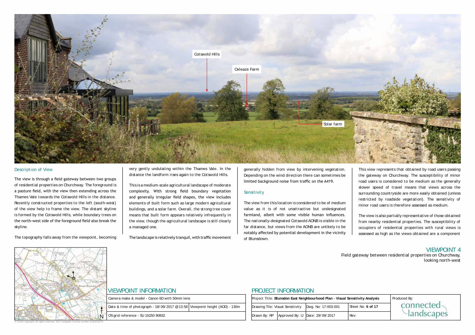
VIEWPOINT 4Field gateway between residential properties on Churchway,
looking north-west
© Crown copyright, All rights reserved. 2017 emapsite Licence number 0100031673
Camera make & model - Canon 6D with 50mm lens
VIEWPOINT INFORMATION
Date & time of photograph - 18/09/2017 @ 13:58
OS grid reference - SU 15250 90832
Viewpoint height (AOD) - 130m
Description of View
The view is through a field gateway between two groups of residential properties on Churchway. The foreground is
a pasture field, with the view then extending across the Thames Vale towards the Cotswold Hills in the distance.
Recently constructed properties to the left (south-west)
of the view help to frame the view. The distant skyline
is formed by the Cotswold Hills, while boundary trees on
the north-west side of the foreground field also break the skyline.
The topography falls away from the viewpoint, becoming
very gently undulating within the Thames Vale. In the
distance the landform rises again to the Cotswold Hills.
This is a medium-scale agricultural landscape of moderate
complexity. With strong field boundary vegetation and generally irregular field shapes, the view includes elements of built form such as large modern agricultural
buildings, and a solar farm. Overall, the strong tree cover
means that built form appears relatively infrequently in
the view, though the agricultural landscape is still clearly
a managed one.
The landscape is relatively tranquil, with traffic movement
generally hidden from view by intervening vegetation.
Depending on the wind direction there can sometimes be
limited background noise from traffic on the A419.
Sensitivity
The view from this location is considered to be of medium
value as it is of not unattractive but undesignated
farmland, albeit with some visible human influences. The nationally-designated Cotswold AONB is visible in the
far distance, but views from the AONB are unlikely to be
notably affected by potential development in the vicinity of Blunsdown.
This view represents that obtained by road users passing
the gateway on Churchway. The susceptibility of minor
road users is considered to be medium as the generally
slower speed of travel means that views across the
surrounding countryside are more easily obtained (unless
restricted by roadside vegetation). The sensitivity of
minor road users is therefore assessed as medium.
The view is also partially representative of those obtained
from nearby residential properties. The susceptibility of
occupiers of residential properties with rural views is
assessed as high as the views obtained are a component
N
Cotswold Hills
Solar farm
Oxleaze Farm
Project Title: Blunsdon East Neighbourhood Plan - Visual Sensitivity Analysis
PROJECT INFORMATION
Drawing Tile: Visual Sensitivity
Drawn By: RP
Dwg. No: 17-003-001
Approved By: IJ
Sheet No: 7 of 17
Date: 29/09/2017 Rev:
Produced By:
VIEWPOINT 4Field gateway between residential properties on Churchway,
looking north-west
© Crown copyright, All rights reserved. 2017 emapsite Licence number 0100031673
Camera make & model - Canon 6D with 50mm lens
VIEWPOINT INFORMATION
Date & time of photograph - 18/09/2017 @ 13:58
OS grid reference - SU 15250 90832
Viewpoint height (AOD) - 130m
of occupiers’ enjoyment of their homes. The sensitivity of
such residential receptors is therefore assessed as high.
The overall sensitivity of receptors observing this view is
considered to be high.
N

Project Title: Blunsdon East Neighbourhood Plan - Visual Sensitivity Analysis
PROJECT INFORMATION
Drawing Tile: Visual Sensitivity
Drawn By: RP
Dwg. No: 17-003-001
Approved By: IJ
Sheet No: 8 of 17
Date: 29/09/2017 Rev:
Produced By:
VIEWPOINT 5Field gateway at south-east end of Little Rose Lane,
looking south-east
© Crown copyright, All rights reserved. 2017 emapsite Licence number 0100031673
Camera make & model - Canon 6D with 50mm lens
VIEWPOINT INFORMATION
Date & time of photograph - 18/09/2017 @ 15:20
OS grid reference - SU 14264 92064
Viewpoint height (AOD) - 85m
Description of View
The view is over a low section of roadside hedgerow and
a field gate, and across arable farmland towards the rising ground on which the main part of Broad Blunsdon
is located.
The skyline is predominantly formed by trees and built
form on the rising ground of Broad Blunsdon, though to
the left (east) and right (south), the skyline is formed by
tree cover within the Thames Vale.
The foreground topography is broadly flat to very gently
undulating, and then rises to approximately 140-145m
AOD around the main part of Broad Blunsdon.
This is a medium-scale, agricultural landscape of
moderate complexity, though located close to the edge
of Broad Blunsdon. The built form of Broad Blunsdon is a
notable feature within the local landscape, though strong
field boundary and other vegetation helps the settlement to fit within the landscape. Outside of the settlement boundaries, the agricultural landscape is still clearly a
managed one.
The landscape is relatively tranquil, with traffic movement
generally hidden from view by intervening vegetation.
Depending on the wind direction there can sometimes
be limited background noise from traffic on the A419. Built form within Broad Blunsdon does add busyness to
the view and thereby reduces the perceived tranquillity
of the view.
Sensitivity
The view from this location is considered to be of medium
value as it is of not unattractive but undesignated
farmland, albeit with a clear presence of built form set
amongst strong tree cover.
This view represents that obtained by road users
passing the gateway at the end of Little Rose Lane. The susceptibility of minor road users is considered to be
medium as the generally slower speed of travel means
that views across the surrounding countryside are more
easily obtained (unless restricted by roadside vegetation).
The sensitivity of minor road users is therefore assessed
as medium.
The overall sensitivity of receptors observing this view is
considered to be medium.
N
Castle Hill
Longfield Farm
Built form within
Broad Blunsdon

Project Title: Blunsdon East Neighbourhood Plan - Visual Sensitivity Analysis
PROJECT INFORMATION
Drawing Tile: Visual Sensitivity
Drawn By: RP
Dwg. No: 17-003-001
Approved By: IJ
Sheet No: 9 of 17
Date: 29/09/2017 Rev:
Produced By:
VIEWPOINT 6Public footpath to south-east of Broadbush,
looking south-east
© Crown copyright, All rights reserved. 2017 emapsite Licence number 0100031673
Camera make & model - Canon 6D with 50mm lens
VIEWPOINT INFORMATION
Date & time of photograph - 18/09/2017 @ 12:36
OS grid reference - SU 15714 90242
Viewpoint height (AOD) - 133m
Description of View
The view is across the valley of a tributary of the
Bydemill Brook. The view to the north and east comprises
neatly mown horse paddocks in the foreground, with
the tree lined stream in the bottom of the valley and
arable farmland on the opposite side of the valley.
The view to the south and south-east is restricted by a
strong hedgerow with frequent, sometimes continuous,
hedgerow trees. Where views to the south are possible
(here over a field gateway), the view is across further pasture fields with strong field boundary vegetation.
The skyline is predominantly formed by trees, either on
the rising ground on the far side the valley or, in some
directions, by those in the foreground. The topography
drops away to the tree-lined stream in the bottom of the
valley, and then rises again beyond.
This is a medium-scale, agricultural landscape of
moderate complexity. Field sizes are variable - smaller
horse paddocks and larger arable fields, while tree cover and topography are the dominant features within the
landscape. The agricultural landscape is still clearly a
managed one, with fences and parked farm machinery
adding complexity to the view.
The landscape is relatively tranquil, with traffic movement generally hidden from view by intervening vegetation.
Depending on the wind direction there can sometimes be
limited background noise from traffic on the A419. Built form along Broadbush (behind the viewpoint) reduces the
perceived tranquillity of the landscape, adding an edge-
of-settlement feel.
Land on the nearside of the valley (including the viewpoint) lies within the Swindon Borough Local Plan
Non-Coalescence Area, while visible land on the far side
of the valley lies within the Kingsdown Allocated Site
(Policy NC5).
Sensitivity
The view from this location is considered to be of medium
value as it is of not unattractive but undesignated
farmland with strong tree cover.
The susceptibility of users of PRoWs is considered to
be high as views of the surrounding countryside are an
N
Land within Kingsdown Allocated Site (Policy NC5)
Footpath
Trees lining tributary of
the Bydemill Brook

Project Title: Blunsdon East Neighbourhood Plan - Visual Sensitivity Analysis
PROJECT INFORMATION
Drawing Tile: Visual Sensitivity
Drawn By: RP
Dwg. No: 17-003-001
Approved By: IJ
Sheet No: 10 of 17
Date: 29/09/2017 Rev:
Produced By:
VIEWPOINT 6 (CONT.)Public footpath to south-east of Broadbush,
looking south-east
© Crown copyright, All rights reserved. 2017 emapsite Licence number 0100031673
Camera make & model - Canon 6D with 50mm lens
VIEWPOINT INFORMATION
Date & time of photograph - 18/09/2017 @ 12:36
OS grid reference - SU 15714 90242
Viewpoint height (AOD) - 133m
important component of users’ experience and enjoyment
of the route. The sensitivity of PRoW users is therefore
assessed as high.
The view is also partially representative of those obtained
from nearby residential properties on the south-east
side of Broadbush. The susceptibility of occupiers of
residential properties with rural views is assessed as high
as the views obtained are a component of occupiers’
enjoyment of their homes. The sensitivity of such
residential receptors is therefore assessed as high.
The overall sensitivity of receptors observing this view is
considered to be high.
N
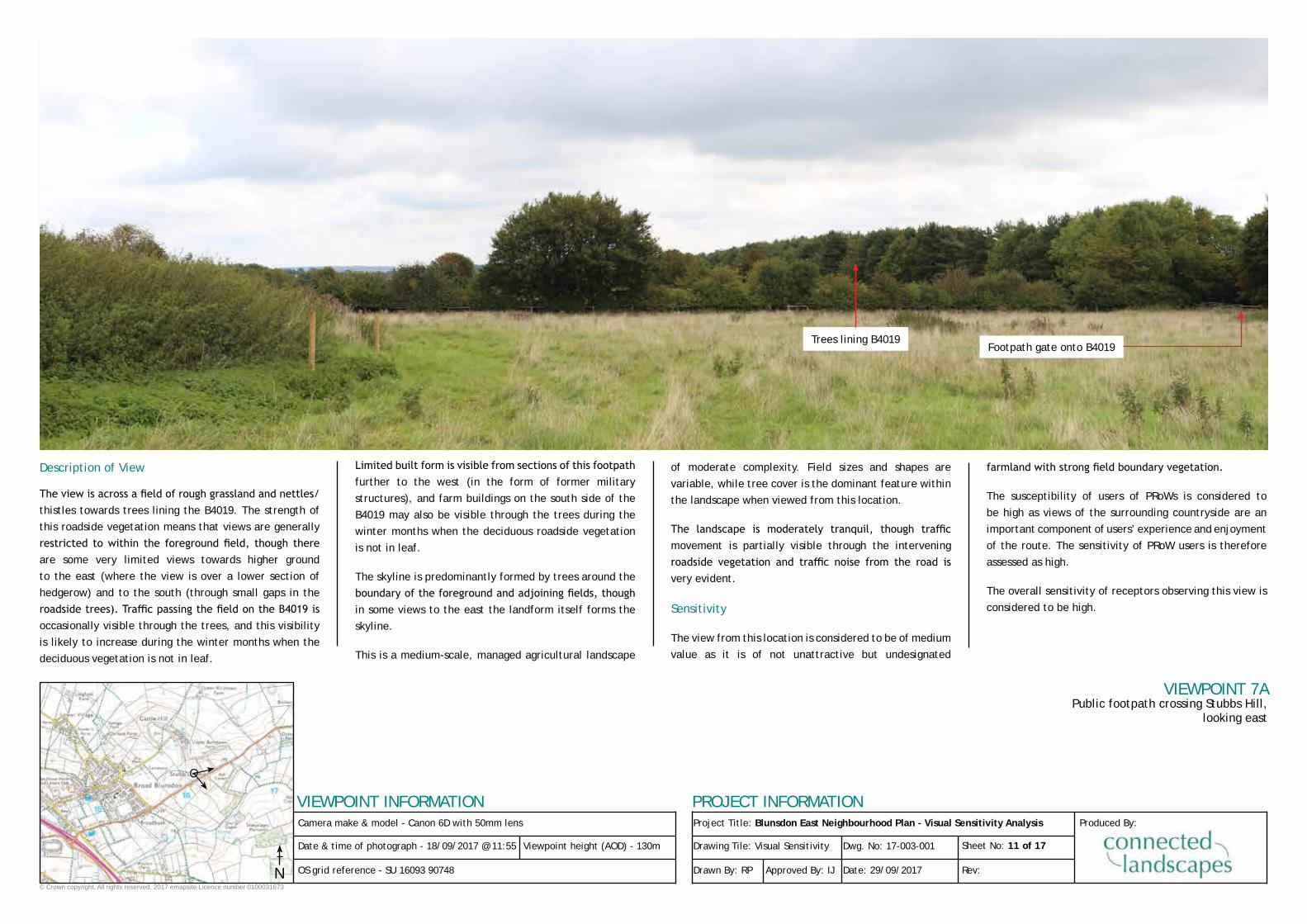
Project Title: Blunsdon East Neighbourhood Plan - Visual Sensitivity Analysis
PROJECT INFORMATION
Drawing Tile: Visual Sensitivity
Drawn By: RP
Dwg. No: 17-003-001
Approved By: IJ
Sheet No: 11 of 17
Date: 29/09/2017 Rev:
Produced By:
VIEWPOINT 7APublic footpath crossing Stubbs Hill,
looking east
© Crown copyright, All rights reserved. 2017 emapsite Licence number 0100031673
Camera make & model - Canon 6D with 50mm lens
VIEWPOINT INFORMATION
Date & time of photograph - 18/09/2017 @ 11:55
OS grid reference - SU 16093 90748
Viewpoint height (AOD) - 130m
Description of View
The view is across a field of rough grassland and nettles/thistles towards trees lining the B4019. The strength of
this roadside vegetation means that views are generally
restricted to within the foreground field, though there are some very limited views towards higher ground
to the east (where the view is over a lower section of
hedgerow) and to the south (through small gaps in the
roadside trees). Traffic passing the field on the B4019 is occasionally visible through the trees, and this visibility
is likely to increase during the winter months when the
deciduous vegetation is not in leaf.
Limited built form is visible from sections of this footpath further to the west (in the form of former military
structures), and farm buildings on the south side of the
B4019 may also be visible through the trees during the
winter months when the deciduous roadside vegetation
is not in leaf.
The skyline is predominantly formed by trees around the
boundary of the foreground and adjoining fields, though in some views to the east the landform itself forms the
skyline.
This is a medium-scale, managed agricultural landscape
of moderate complexity. Field sizes and shapes are
variable, while tree cover is the dominant feature within
the landscape when viewed from this location.
The landscape is moderately tranquil, though traffic movement is partially visible through the intervening
roadside vegetation and traffic noise from the road is very evident.
Sensitivity
The view from this location is considered to be of medium
value as it is of not unattractive but undesignated
farmland with strong field boundary vegetation.
The susceptibility of users of PRoWs is considered to
be high as views of the surrounding countryside are an
important component of users’ experience and enjoyment
of the route. The sensitivity of PRoW users is therefore
assessed as high.
The overall sensitivity of receptors observing this view is
considered to be high.
N
Footpath gate onto B4019Trees lining B4019

Project Title: Blunsdon East Neighbourhood Plan - Visual Sensitivity Analysis
PROJECT INFORMATION
Drawing Tile: Visual Sensitivity
Drawn By: RP
Dwg. No: 17-003-001
Approved By: IJ
Sheet No: 12 of 17
Date: 29/09/2017 Rev:
Produced By:
VIEWPOINT 7BPublic footpath crossing Stubbs Hill,
looking south-east
© Crown copyright, All rights reserved. 2017 emapsite Licence number 0100031673
Camera make & model - Canon 6D with 50mm lens
VIEWPOINT INFORMATION
Date & time of photograph - 18/09/2017 @ 11:55
OS grid reference - SU 16093 90748
Viewpoint height (AOD) - 130m
N
Footpath gate onto B4019Trees lining B4019

Project Title: Blunsdon East Neighbourhood Plan - Visual Sensitivity Analysis
PROJECT INFORMATION
Drawing Tile: Visual Sensitivity
Drawn By: RP
Dwg. No: 17-003-001
Approved By: IJ
Sheet No: 13 of 17
Date: 29/09/2017 Rev:
Produced By:
VIEWPOINT 7CPublic footpath crossing Stubbs Hill,
looking south
© Crown copyright, All rights reserved. 2017 emapsite Licence number 0100031673
Camera make & model - Canon 6D with 50mm lens
VIEWPOINT INFORMATION
Date & time of photograph - 18/09/2017 @ 11:55
OS grid reference - SU 16093 90748
Viewpoint height (AOD) - 130m
N
Trees lining B4019

Project Title: Blunsdon East Neighbourhood Plan - Visual Sensitivity Analysis
PROJECT INFORMATION
Drawing Tile: Visual Sensitivity
Drawn By: RP
Dwg. No: 17-003-001
Approved By: IJ
Sheet No: 14 of 17
Date: 29/09/2017 Rev:
Produced By:
VIEWPOINT 8APublic footpath between Broadbush
and Kingsdown Lane, looking west
© Crown copyright, All rights reserved. 2017 emapsite Licence number 0100031673
Camera make & model - Canon 6D with 50mm lens
VIEWPOINT INFORMATION
Date & time of photograph - 28/09/2017 @ 10:10
OS grid reference - SU 15979 89880
Viewpoint height (AOD) - 126m
Description of View
The view is across the valley of a tributary of the Bydemill
Brook, looking north-west towards the residential
properties on the south-east side Broadbush. The
foreground to the view comprises grass fields/paddocks on either side of the valley, and a strong belt of riverine
trees lining the tributary of the Bydemill Brook at the
bottom of the valley.
The skyline is formed by trees (and occasional residential
properties amongst them) on the far side the valley or,
in some directions, by hedgerows with hedgerow trees
in the foreground. Inter-visibility is limited to within
the valley. The topography drops away to the tree-lined
stream in the bottom of the valley, and then rises again
beyond to Broadbush.
This is a medium-scale, agricultural landscape of
moderate complexity. Field sizes are variable, while tree
cover and valley topography are the dominant features
within the landscape. The pastoral landscape is clearly a
managed one, influenced by built from on the south-east edge of Broad Blunsdon/Broadbush.
The landscape is relatively tranquil, though there can
sometimes be limited background noise from traffic on the A419, depending on the wind direction. Built form
along Broadbush reduces the perceived tranquillity of the
landscape, adding an edge-of-settlement feel.
Land on the far side of the valley lies within the Swindon Borough Local Plan Non-Coalescence Area, while land on the nearside of the valley (including the viewpoint) lies
within the Kingsdown Allocated Site (Policy NC5).
Sensitivity
The view from this location is considered to be of medium
value as it is of not unattractive but undesignated
farmland, with strong tree cover and limited elements
of built form.
The susceptibility of users of PRoWs is considered to
be high as views of the surrounding countryside are an
important component of users’ experience and enjoyment
of the route. The sensitivity of PRoW users is therefore
assessed as high.
N
Trees lining tributary of
the Bydemill Brook

Project Title: Blunsdon East Neighbourhood Plan - Visual Sensitivity Analysis
PROJECT INFORMATION
Drawing Tile: Visual Sensitivity
Drawn By: RP
Dwg. No: 17-003-001
Approved By: IJ
Sheet No: 15 of 17
Date: 29/09/2017 Rev:
Produced By:
VIEWPOINT 8BPublic footpath between Broadbush and Kingsdown Lane,
looking north-west
© Crown copyright, All rights reserved. 2017 emapsite Licence number 0100031673
Camera make & model - Canon 6D with 50mm lens
VIEWPOINT INFORMATION
Date & time of photograph - 28/09/2017 @ 10:10
OS grid reference - SU 15979 89880
Viewpoint height (AOD) - 126m
The overall sensitivity of receptors observing this view is
considered to be high.
N
Footpath
Properties on
Broadbush
Trees lining tributary of
the Bydemill Brook

Project Title: Blunsdon East Neighbourhood Plan - Visual Sensitivity Analysis
PROJECT INFORMATION
Drawing Tile: Visual Sensitivity
Drawn By: RP
Dwg. No: 17-003-001
Approved By: IJ
Sheet No: 16 of 17
Date: 29/09/2017 Rev:
Produced By:
VIEWPOINT 9Back Lane, at junction with Ivy Lane,
looking north
© Crown copyright, All rights reserved. 2017 emapsite Licence number 0100031673
Camera make & model - Canon 6D with 50mm lens
VIEWPOINT INFORMATION
Date & time of photograph - 18/09/2017 @ 15:04
OS grid reference - SU 14933 90926
Viewpoint height (AOD) - 106m
Description of View
The view is across the Thames Vale towards the Cotswold
Hills. Roadside and field boundary hedgerows partially restrict views, though growth patterns suggest that
these are regularly trimmed. Land use is predominantly pastoral close to Broad Blunsdon, but arable farming is
also present.
There is limited built form within the view to the north -
isolated farmsteads and large industrial-type buildings at
RAF Fairford. Powerlines mounted on timber poles cross
the foreground, while traffic on Back Lane and Ivy Lane is also obviously visible.
The altitude of the viewpoint, though lower than the
main part of Broad Blunsdon, is still sufficient to still allow long views across the Vale with little interruption
from intervening field boundary vegetation.
The skyline is generally formed by tree cover or by the
Cotswold hills in the far distance.
This is a medium-scale, managed agricultural landscape
of moderate complexity. Field sizes and shapes are
variable, while tree boundary vegetation and the distant
Cotswold Hills are the dominant features within the
landscape.
The landscape is moderately tranquil, though traffic passing on Back Lane/Ivy Lane is obviously very evident. Depending on the wind direction, there may also be some
background noise from traffic on the A419 to the south-west.
Sensitivity
The view from this location is considered to be of medium
value as it is of not unattractive but undesignated
farmland with strong field boundary vegetation. The nationally-designated Cotswold AONB is visible in the
far distance, but views from the AONB are unlikely to be
notably affected by potential development in the vicinity of Blunsdown.
This view represents that obtained by road users
passing between Broad Blunsdon and Lower Village. The
N
Access road to
Oxleaze Farm
Cotswold Hills

Project Title: Blunsdon East Neighbourhood Plan - Visual Sensitivity Analysis
PROJECT INFORMATION
Drawing Tile: Visual Sensitivity
Drawn By: RP
Dwg. No: 17-003-001
Approved By: IJ
Sheet No: 17 of 17
Date: 29/09/2017 Rev:
Produced By:
VIEWPOINT 9 (CONT.)Back Lane, at junction with Ivy Lane,
looking north
© Crown copyright, All rights reserved. 2017 emapsite Licence number 0100031673
Camera make & model - Canon 6D with 50mm lens
VIEWPOINT INFORMATION
Date & time of photograph - 18/09/2017 @ 15:04
OS grid reference - SU 14933 90926
Viewpoint height (AOD) - 106m
susceptibility of minor road users is considered to be
medium as the generally slower speed of travel means
that views across the surrounding countryside are more
easily obtained (unless restricted by roadside vegetation).
The sensitivity of minor road users is therefore assessed
as medium.
The view is also representative of those obtained by
the occupants of nearby residential properties. The
susceptibility of occupiers of residential properties with
rural views is assessed as high as the views obtained are
a component of occupiers’ enjoyment of their homes.
The sensitivity of such residential receptors is therefore
assessed as high.
The overall sensitivity of receptors observing this view is
considered to be high.
N