langstone coastal defence study january 2020 design updatelangstone coastal defence study january...
TRANSCRIPT

Langstone Coastal Defence Study Langstone Coastal Defence Study January 2020 Design UpdateJanuary 2020 Design Update
Reducing Coastal Flood and Erosion Risk to the Langstone CommunityReducing Coastal Flood and Erosion Risk to the Langstone Community


ContentsContentsWho are the ESCP?Coastal roles and responsibilitiesWhy we are hereClimate change and sea level riseFunding challengesHeritage considerationsEnvironmental considerationsThe choicesStory so farCore scheme overviewLangstone WestThe Ship InnLangstone VillageRoyal OakWhat happens next?
234 5678910111213141516

Who are the ESCP?Who are the ESCP?Eastern Solent Coastal Eastern Solent Coastal PartnershipPartnership
The ESCP are a team of council officers delivering comprehensive coastal management services across the coastlines of Fareham, Gosport, Havant and Portsmouth.
These different activities are distributed across These different activities are distributed across three teams:three teams:
Partnership Vision:Partnership Vision:“To reduce the risk of coastal flooding and “To reduce the risk of coastal flooding and erosion to our communities and encourage the erosion to our communities and encourage the provision of technically, environmentally and provision of technically, environmentally and economically sustainable coastal defence and economically sustainable coastal defence and protection measures.”protection measures.”
The ESCP has been recognised as an example of best practice by the Environment Agency and Defra, with suggestions that the model should be encouraged across the rest of the country.
Map of ESCP coverage
Since 2012 we have been delivering projects to the highest standard, reducing coastal flood and erosion risk to thousands of homes and businesses. The Partnership has surpassed the work that each Local Authority could have achieved in isolation delivering multi-million pound projects while making a combined saving of £1.8 million.
The ESCP undertakes a broad range of coastal The ESCP undertakes a broad range of coastal management activities, including:management activities, including:
• Coastal Policy, Strategy and Environment• Capital Projects• Operations
• Setting coastal management policy, through the development of Shoreline Management Plans and Coastal Strategies
• Designing and implementing civil engineering schemes
• Regular management, inspection and maintenance of sea defences
• Identifying opportunities to enhance our coastal environment
• Leading and contributing to industry research• Engaging with local communities, organisations
and businesses on all aspects of our work
Above left: Anchorage Park Coastal Defences with Wildflower Meadow. Above right: Tipner Lake Coastal Path with Paving and Giant Sun loungers. Below: Hill Head Coastal Defence Wall with Safety Rail.
2

3
Coastal roles and Coastal roles and responsibilitiesresponsibilities
Private land owners and homeowners have ultimate responsibility for protecting their own property and land from flooding and erosion and they must act within statutory planning regulations and other applicable legislation to do so.
Who is responsible?Who is responsible?
How schemes are fundedHow schemes are funded
The Government has put in place a mechanism for funding flood and coastal erosion risk management schemes called Partnership Funding. The principles are quite simple, where projects do not qualify for full government funding, external funding contributions can be sought to make up the shortfall.
Coastal Protection Authorities and the Environment Agency have permissive powers to carry out works to protect against coastal flooding and erosion. However this is not a legal obligation. This means Havant Borough Council has the ‘power’ to carry out coastal protection works but is not duty bound to do so and will not be liable for the failure to exercise these powers.
Local Authorities and the Environment Agency do however act to try and secure funding and deliver projects where there are sufficient benefits to the public, i.e. when there is a clear economic benefit to developing coastal defence works, when there is an appropriate engineering solution that is achievable and where environmental legislation is not contravened.
A scheme at Langstone is not guaranteed to attract full government funding, therefore we are actively working with the council and external partners to explore opportunities to identify additional funding for the scheme.
1100% funded00% funded
Partial Partial funding funding availablavailablee ......
... savings or ... savings or other funding other funding
requiredrequired
Val
ue fo
r Mon
eyV
alue
for M
oney
Funding ScoreFunding Score0%0% 100%100%% costs met by FDGiA% costs met by FDGiA (Flood Defence Grant in Aid) (Flood Defence Grant in Aid)

4
Why we are here?Why we are here?
North Solent Shoreline Management PlanNorth Solent Shoreline Management PlanThe North Solent Shoreline Management Plan (SMP) is a high level policy document setting out a framework for future management of the coastline over the next 100 years. It was adopted by Havant Borough Council in 2010 and recommends a ‘Hold the line’ policy to maintain or upgrade the level of protection provided by the coastal defences in Langstone.
Portchester Castle to Emsworth StrategyPortchester Castle to Emsworth StrategyThe Portchester to Emsworth Strategy covers a 27km stretch of coastline marking The Portchester to Emsworth Strategy covers a 27km stretch of coastline marking the northern boundaries of Portsmouth, Langstone and Chichester Harbours. The the northern boundaries of Portsmouth, Langstone and Chichester Harbours. The Strategy looks at how the SMP policy can be implemented at a more local level and Strategy looks at how the SMP policy can be implemented at a more local level and identifies areas where work may be required over the next 100 years. The Strategy identifies areas where work may be required over the next 100 years. The Strategy recommended improvement of the defences at Langstone through a phased approach.recommended improvement of the defences at Langstone through a phased approach.
Langstone StudyLangstone StudyCurrent defences are in poor condition and some are reaching the end of their life, so there is a need to address these issues now in order to reduce flood risk to the Langstone community moving forward into the future. Due to sea level rise, in 100 years time more than 120 homes in Langstone are at risk of tidal flooding in an extreme event. The aim of this study is to develop coastal management options to reduce the flood and erosion risk to the community, important heritage assets and the A3023, the only road crossing to Haying Island.
20102010
20132013
20182018
Present day 1 in 200 year coastal flood event (2019)Present day 1 in 200 year coastal flood event (2019) Predicted 1 in 200 year coastal flood event (2119)Predicted 1 in 200 year coastal flood event (2119)
Aerial Photography: Channel Coastal Observatory (2013) Aerial Photography: Channel Coastal Observatory (2013)
Properties at risk of flooding and erosion Properties at risk of flooding and erosion over the coming century if we ‘Do over the coming century if we ‘Do Nothing’. Based on 1 : 200 year (0.5% Nothing’. Based on 1 : 200 year (0.5% annual chance) flood event.annual chance) flood event.
YEARYEAR RESIDENTIALRESIDENTIAL COMMERCIALCOMMERCIAL TOTALTOTAL
PRESENT DAY 72 4 76
2119 122 9 131

5
Climate change and Climate change and sea level risesea level rise
In all our designs we have to take account of and plan for sea level rise. Scientists have determined that the temperature of central England has risen by almost 1oC over the last century. Winters are getting increased rainfall and average sea levels are rising.
The long-term effects of climate change are uncertain, however in some shape or form it will affect us all. With this in mind we must start acting now to protect our coastline and ensure that our actions are sustainable for future generations.
Havant Borough Council takes human-induced climate change very seriously. Many of the services that they provide directly affect the local economy and the environment. When developing the Council Strategies and how services are being delivered, the council will always consider how these things could affect climate change and how communities can respond to the effects of climate change.
Planning for the long term future of our Coastal CommunitiesPlanning for the long term future of our Coastal Communities
Our ResponsibilityOur ResponsibilityClimate ChangeClimate ChangeRelative sea level rises refer to the effective change in sea level in relation to the land surface and takes into account long term land movement. The combined effect of these changes are predicted to result in an annual sea level rise in Southern England of about 6mm per year.
The rise in sea level due to global warming is caused by thermal expansion of the oceans and to a lesser extent from melting of ice caps and glaciers.
The relative rise in sea level is also caused by a phenomenon called isostatic readjustment. Effectively the north-west of Britain is rising following glacial withdrawal at the end of the last ice age, thus causing the south-east of England to sink.

6
Funding challengesFunding challenges
The Eastern Solent Coastal Partnership, on behalf of Havant Borough Council are undertaking this coastal defence study to appraise options and develop outline designs for defences at Langstone.
The objectives of the study are: The objectives of the study are:
Identify the most appropriate way forward to manage Langstone’s flood and erosion risks into the future
Cost the leading approach
Develop a business case for the leading approach
Identify potential sources of funding to progress a scheme
Funding has only been secured for this study. Funding has only been secured for this study. FUNDING IS NOT guaranteed for detailed design and FUNDING IS NOT guaranteed for detailed design and
construction at this point.construction at this point.
Appraisal and Outline Appraisal and Outline Design StageDesign Stage
Detailed Design and Detailed Design and ConstructionConstruction
£75,000£75,000HBC Community Infrastructure Levy HBC Community Infrastructure Levy
(CIL) secured(CIL) secured
£301,000£301,000Southern Regional Flood & Coastal Southern Regional Flood & Coastal
Committee (RFCC) Local Levy securedCommittee (RFCC) Local Levy secured
£2.55 million£2.55 million HBC CIL secured via HBC CIL secured via
pot buildingpot building
Shortfall for Shortfall for construction of the core construction of the core
schemescheme
Potential sources being explored:Potential sources being explored:Grant in Aid (GiA), RFCC Local Levy, Grant in Aid (GiA), RFCC Local Levy,
Highways England, Hampshire County Highways England, Hampshire County Council, private contributions, Council, private contributions,
community/fundraisingcommunity/fundraising
?

The coastline at Langstone is popular with locals and tourists due to its unique setting and is an important cultural heritage area.
Two conservation areas lie within the study area; Mill Lane and Langstone.
Langstone was an important area in the Roman period and the A3023 follows the line of the Roman road that ran from Hayling Island to Havant. The area also has potential for prehistoric and medieval buried archaeology.
Mill Lane & Langstone Mill Lane & Langstone Conservation AreasConservation Areas
ArchaeologyArchaeologyThe popular Hayling Bill Trail follows the route of The popular Hayling Bill Trail follows the route of the former railway line that connected Havant the former railway line that connected Havant with Hayling Island. At low tide you can see the with Hayling Island. At low tide you can see the remains of the old bridge footings extending from remains of the old bridge footings extending from the relic spit across to Hayling Island.the relic spit across to Hayling Island.
Hayling Billy TrailHayling Billy Trail
An historic causeway, known as the Wadeway, was An historic causeway, known as the Wadeway, was initially the only crossing between Langstone and initially the only crossing between Langstone and Hayling Island before the bridge was built.Hayling Island before the bridge was built.
Historic CausewayHistoric Causeway
Hayling ‘Billy’ train crossing onto the island. (A history of the Hayling Hayling ‘Billy’ train crossing onto the island. (A history of the Hayling Island Brach Line by Ralph Cousins -photograph by Alan Bell). Island Brach Line by Ralph Cousins -photograph by Alan Bell).
The First Road Bridge and Langstone Quay . (A Langstone The First Road Bridge and Langstone Quay . (A Langstone Miscellany –Ann Griffiths)Miscellany –Ann Griffiths)
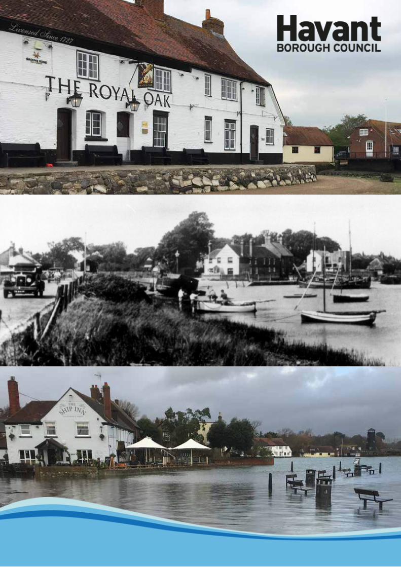
Langstone has 7 Grade II Listed buildings including The Ship Inn and the Royal Oak public houses, all of which lie within the flood risk area.
The Royal Oak The Ship Inn
Langstone House with cottage and shellfish store, now The Winkle Market. (A Langstone Miscellany –Ann Griffiths)
Heritage considerationsHeritage considerations7
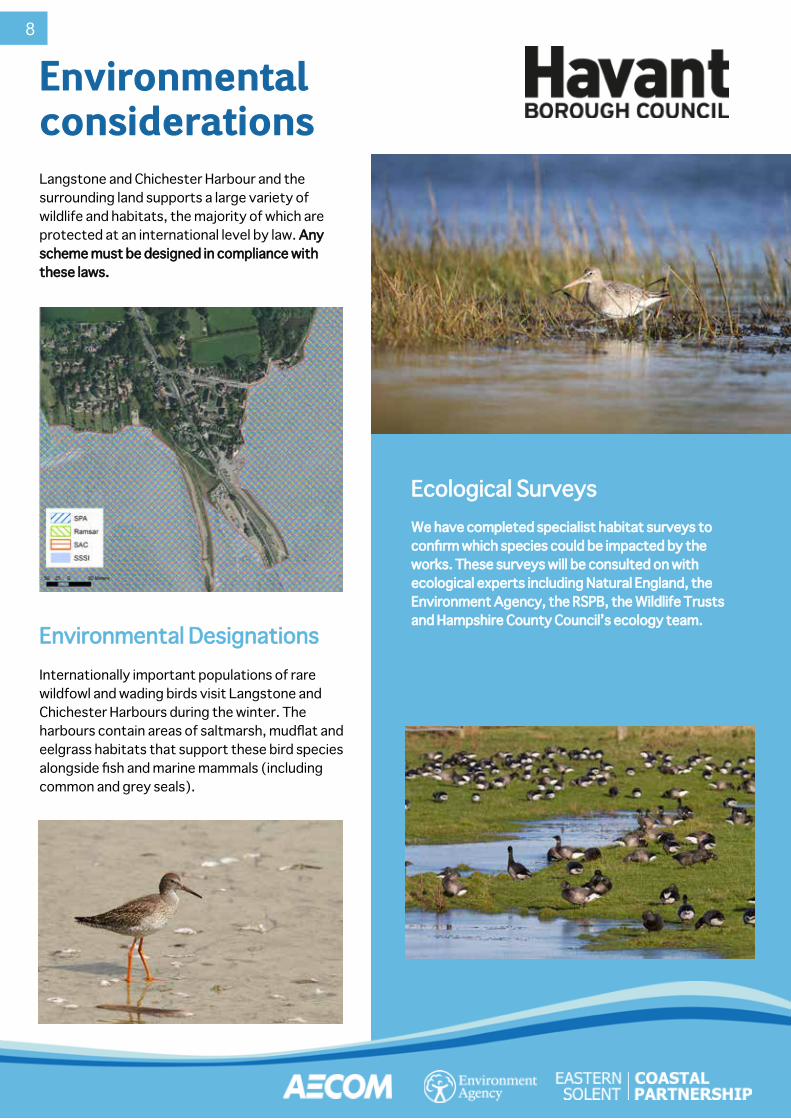
Langstone and Chichester Harbour and the surrounding land supports a large variety of wildlife and habitats, the majority of which are protected at an international level by law. Any Any scheme must be designed in compliance with scheme must be designed in compliance with these laws.these laws.
Internationally important populations of rare wildfowl and wading birds visit Langstone and Chichester Harbours during the winter. The harbours contain areas of saltmarsh, mudflat and eelgrass habitats that support these bird species alongside fish and marine mammals (including common and grey seals).
We have completed specialist habitat surveys to We have completed specialist habitat surveys to confirm which species could be impacted by the confirm which species could be impacted by the works. These surveys will be consulted on with works. These surveys will be consulted on with ecological experts including Natural England, the ecological experts including Natural England, the Environment Agency, the RSPB, the Wildlife Trusts Environment Agency, the RSPB, the Wildlife Trusts and Hampshire County Council’s ecology team.and Hampshire County Council’s ecology team.
Environmental DesignationsEnvironmental Designations
Ecological SurveysEcological Surveys
Environmental Environmental considerationsconsiderations
8
9
What are the choices?What are the choices?
Do SomethingDo Something“Leading “Leading Option”Option”
AdaptationAdaptation“Managing “Managing
Change”Change”Do NothingDo Nothing
“Walk Away”“Walk Away”
Replace / improve failing coastal defences as sensitively as possible but accept that it will change the way the coastline currently looks.
Reduce flood and erosion risk to Langstone properties and businesses
Preserve the conservation areas and protect important heritage assets for the future
Reduce flood risk to the A3023, critical road infrastructure to Hayling Island
A resilient village for the next generation
Adapt to living with the consequences of sea level rise and climate change through:
• Adaptation of properties, i.e. property level resilience
• Effective flood warnings• Evacuation • Changing use or loss of
properties at immediate risk
• Altering proposed new infrastructure to protect only the A3023
• Undertake no new front line flood and erosion protection works
• Ultimately relocate people
Flood and erosion risk, unmanaged and will increase significantly over time to properties and A3023
Existing defences will continue to deteriorate and eventually fail
Conservation area and heritage at significant risk of damage or loss
When defences fail, frontline properties at immediate risk of structural damage, undermining or collapsing
Langstone village becomes unsustainable in the long term
Property flood Property flood resilienceresilience
Moving people Moving people to new placesto new places
Flood Flood warningswarnings
EvacuationEvacuationCoastal Coastal
infrastructureinfrastructure
Flood wallsFlood walls
What are your views?What are your views?
HBC are undertaking this study using our permissive powers to promote a public scheme but if we are not able to identify and agree a technically, environmentally acceptable, sustainable and affordable solution then the responsibility will continue to rest with the landowners and residents to take their own measures to live and adapt with climate change and the increasing risk of flooding.
10
Story so farStory so far
20192019
March 2018March 2018
Funds approved from Regional Flood Coastal Funds approved from Regional Flood Coastal Committee (RFCC) and Havant Borough Committee (RFCC) and Havant Borough Council (HBC) Community Infrastructure Levy Council (HBC) Community Infrastructure Levy (CIL) for the Langstone Option appraisal study.(CIL) for the Langstone Option appraisal study. SeptSept
20182018
Langstone Stakeholder Langstone Stakeholder Working Group 1Working Group 1On 5th September 2018, On 5th September 2018, the Langstone Stakeholder the Langstone Stakeholder Working Group was formed Working Group was formed and a workshop held to share and a workshop held to share information, gather feedback, information, gather feedback, concerns and local aspirations. concerns and local aspirations.
Ground Investigation Ground Investigation WorksWorks
Ground Ground Investigation Investigation works carried works carried out along the out along the
frontage. frontage.
Define Long List of Define Long List of OptionsOptions
All potential defence All potential defence measures to measures to
implement various implement various management options management options
were considered.were considered.
Option Development—Reduce Option Development—Reduce to Short List of Optionsto Short List of Options
The longlist of options was cut The longlist of options was cut down to a shortlist by appraising down to a shortlist by appraising each option against a number of each option against a number of
categories or questions using categories or questions using multi-variate analysis. multi-variate analysis.
NovNov20182018
Stakeholder Working Group 2 Stakeholder Working Group 2 Workshop to update on progress, Workshop to update on progress, share the share the shortlisted shortlisted options, the options, the process and process and the next the next steps of the steps of the study.study.
Public Exhibitions on Shortlisted OptionsPublic Exhibitions on Shortlisted OptionsExhibitions to present the short list of Exhibitions to present the short list of options to options to the public the public and gain and gain feedback feedback to inform to inform the leading the leading options.options.
Short List Appraisal and Short List Appraisal and Identify Leading Options:Identify Leading Options:
The leading options were The leading options were selected through similar selected through similar
appraisal for each frontage, appraisal for each frontage, incorporating feedback from incorporating feedback from the public exhibitions, where the public exhibitions, where
feasible to do so.feasible to do so.
June June 20192019
Local Resident Local Resident EngagementEngagement
Face-to-face Face-to-face meetings with meetings with
residents along the residents along the scheme frontage scheme frontage
who may be directly who may be directly affected.affected.
Stakeholder Working Group 3Stakeholder Working Group 3Update on project progress, funding, Update on project progress, funding,
leading options, core scheme leading options, core scheme alignment and alignment and
the next steps.the next steps.
Develop Outline DesignsDevelop Outline DesignsThe leading options for each frontage have The leading options for each frontage have been developed into outline designs. been developed into outline designs.
We Are HereWe Are HerePublic exhibitions to present Public exhibitions to present the leading options to the the leading options to the public and gain further public and gain further feedback.feedback.
20202020
MayMay20182018
Commisioned Commisioned AECOM to provide AECOM to provide professional professional services to deliver services to deliver the Langstone the Langstone Study and Outline Study and Outline Designs.Designs.
Project Start-upProject Start-upFunding SecuredFunding Secured

Affordability is a key constraint and driver for selecting the combination of leading options to identify Affordability is a key constraint and driver for selecting the combination of leading options to identify the scheme alignment, the duration of the scheme and standard of protection the scheme will provide.the scheme alignment, the duration of the scheme and standard of protection the scheme will provide.
The ‘Core Scheme’ represents the most affordable combination of options that protects the greatest The ‘Core Scheme’ represents the most affordable combination of options that protects the greatest number of properties and the A3023 road to Hayling Island.number of properties and the A3023 road to Hayling Island.
With a total cost of £4.5 million (including 60% risk at this outline design stage), this alignment With a total cost of £4.5 million (including 60% risk at this outline design stage), this alignment represents the least-cost scheme, designed to provide a present day 0.5% Annual Exceedance represents the least-cost scheme, designed to provide a present day 0.5% Annual Exceedance Probability (AEP) standard of protection, with a scheme design life of 50 years.Probability (AEP) standard of protection, with a scheme design life of 50 years.
At present, £3.1 million worth of contributions have been secured via HBC Community At present, £3.1 million worth of contributions have been secured via HBC Community Infrastructure Levy (CIL) and Southern Regional Flood and Coastal Committee (RFCC)Infrastructure Levy (CIL) and Southern Regional Flood and Coastal Committee (RFCC) Local Levy, with the potential for an additional £500k of FCERM GiA funding. Local Levy, with the potential for an additional £500k of FCERM GiA funding. However, even with these contributions, However, even with these contributions, there is currently still a £900k shortfall for there is currently still a £900k shortfall for construction of the core scheme. construction of the core scheme. Additional funding streams are being Additional funding streams are being explored to help close this gap. explored to help close this gap.
11
Core scheme overviewCore scheme overview
Due to affordability, there are some areas along the Langstone frontage, including Mill Lane, Langstone Spit and Langstone Sailing Club that are not included in the core scheme.
If additional funding is sourced during the detailed design stage, some or all of these areas could be included in the scheme as ‘add-on’ options.
Engagement with Mill Lane residents is ongoing and the project team have agreed to take the leading options for the Mill Lane area through to detailed design. The ESCP will provide advice and support to these residents, to ultimately include their frontage within the scheme if funding is found or to help them progress repairs etc privately in the future.
Langstone Sailing Club are concerned about the erosion that is occurring at the southern tip of Langstone Spit, and the implications this has on providing protection to their assets. The project team are currently working with them to investigate how this option can be included in the detailed design phase of the project and to provide advice on funding streams to potentially enable it to progress in the future.
ADD-ON OPTIONSADD-ON OPTIONS
What is the core scheme being promoted?What is the core scheme being promoted?
Langstone WestLangstone West
TOPSOIL AND GRASS SEEDED
PROPOSED EARTH EMBANKMENT WIDTH SHOWN AT 1500mm
MIN CREST LEVEL 3.8mAOD
IMPERMEABLE CLAY CORE
PRESENT DAY 1 IN 200 YR EXTREME STILL WATER LEVEL (3.5mAOD)
SHOWN AT 2.97mAOD
PRESENT DAY MHWS (2.21mAOD)
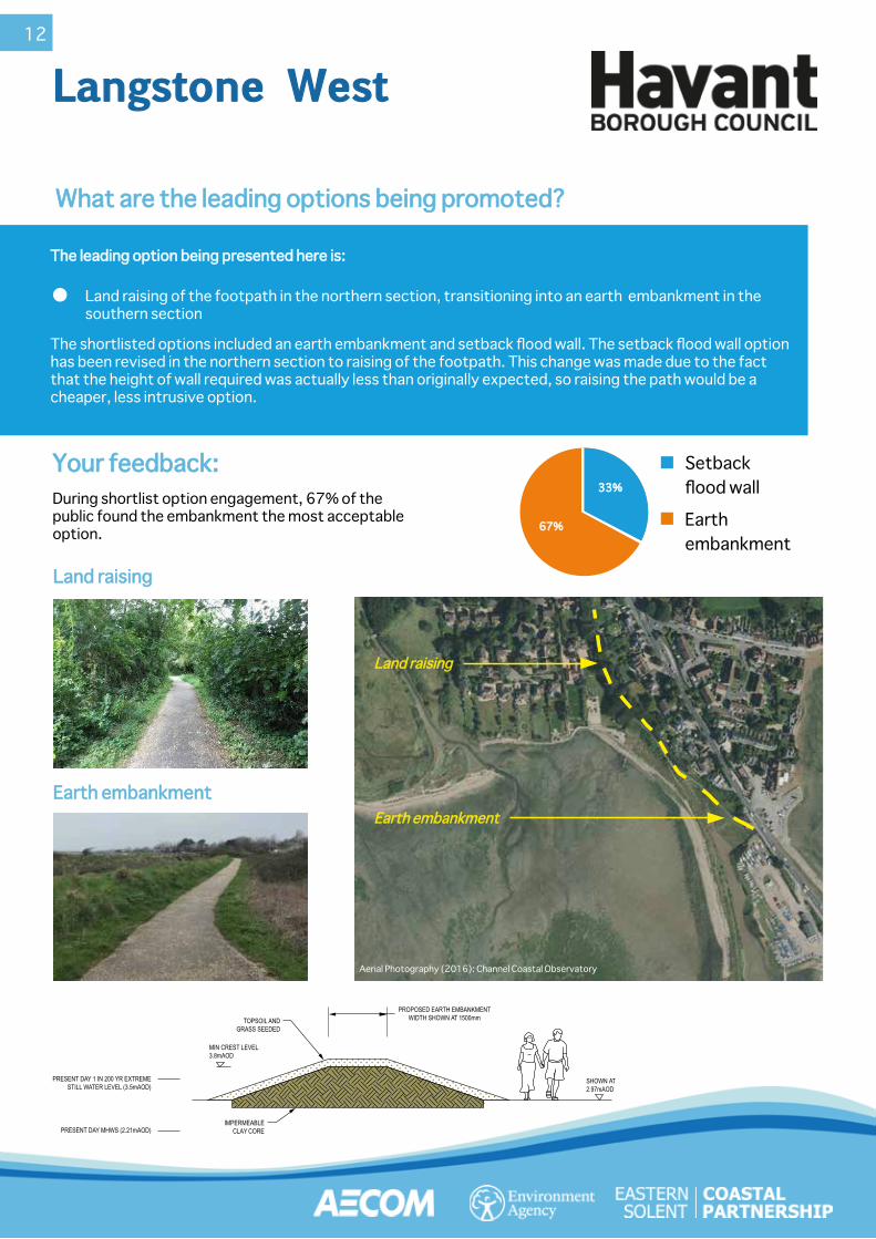
The leading option being presented here is:The leading option being presented here is:
The shortlisted options included an earth embankment and setback flood wall. The setback flood wall option has been revised in the northern section to raising of the footpath. This change was made due to the fact that the height of wall required was actually less than originally expected, so raising the path would be a cheaper, less intrusive option.
What are the leading options being promoted?What are the leading options being promoted?
Land raising of the footpath in the northern section, transitioning into an earth embankment in the southern section
Land raisingLand raising
Earth embankmentEarth embankment
During shortlist option engagement, 67% of the public found the embankment the most acceptable option.
Your feedback:Your feedback:
Land raisingLand raising
Earth embankmentEarth embankment
67%67%
33%33%
Setbackflood wall
Earthembankment
Aerial Photography (2016): Channel Coastal Observatory
12

13
The Ship InnThe Ship Inn
What are the leading options being promoted?What are the leading options being promoted?
Flip up floodwall or floodgate across The Ship Inn car park to tie-in to a small wall beside the A3023.Continued maintenance of the quay wall around the car park.Glass-topped flood wall along the front of The Ship Inn courtyard and adjacent building, includes a floodgate for access, if required.
The shortlisted options also included a set-back flood wall around the quay and flood gates at each slipway. Compared to the flip-up floodwall, these options have similar costs, however the flip-up flood wall was put forward as the leading option on heritage, environmental and social grounds.
The leading options being presented here are:The leading options being presented here are:
* Please note that these visualisations are purely examples and should not be taken literally at this stage as the options will not be determined fully until the next
stage of the project.
39%39%
28%28%
33%33%
Flip-up flood wallSetback flood wallSetback glass topped flood wall
FLIP UP BARRIER (1025mm HEIGHT)
MIN. CREST HEIGHT (3.8mAOD)
PRESENT DAY 1 IN 200 YR EXTREME STILL WATER LEVEL (3.5mAOD)
CONCRETE BASE375mm RECESS TO ACCOMODATE FRAME AND HINGE INSTALLATION
REINSTATEMENT TO MATCH ADJACENT PAVEMENT MATERIAL
SHOWN AT 3.19mAOD
CROSS SECTION C - PROPOSED DEFENCE OPTION FOR ODU 3B FLIP-UP FLOODWALL (1:50)
EXISTING PUB
SHOWN AT 2.84mAOD
EXISTING OUTDOOR SEATS
MIN. 1100mm EDGE PROTECTION
GLASS BARRIERS MOUNTED ON NEW RC WALL
MIN. CREST HEIGHT (3.8mAOD)PRESENT DAY 1 IN 200 YR EXTREME STILL WATER LEVEL (3.5mAOD)
PRESENT DAY MHWS (2.21mAOD)BEACH LEVEL (VARIES)
EXISTING MASONARY WALL (CONDITION TBC) ASSUMING RISK OF UNDERMINING IS NEGLIGIBLE
PROPOSED RC WALL
EXISTING FOUNDATION UNKNOWN
CROSS SECTION D - PROPOSED DEFENCE FOR ODU 3D TO 3E GLASS CRESTED FLOODWALL (1.50)
Glass-topped floodwallGlass-topped floodwall
Current wall
Design visual concrete wall with three different cladding finishes Design visual when raised
Design visual when loweredwww.floodcontrolinternational.com/products/flood-barriers/flip-up.html
During shortlist option engagement, 39% of the public found the flip-up floodwall the most acceptable option.
Your feedback:Your feedback:
Glass-Topped FloodwallGlass-Topped Floodwall
Flip up floodwall Flip up floodwall or floodgateor floodgate
Aerial Photography (2016): Channel Coastal Observatory
Flip-up floodwallFlip-up floodwall

14
The Langstone VillageThe Langstone Village
Setback floodwall with boardwalk Setback floodwall with boardwalk
The leading options being presented here are:The leading options being presented here are:
The shortlisted options also included reinforcing / replacing the existing defence. This option was discounted on cost and technical grounds. Technically there are major constraints associated with reinforcing / replacing the existing defence including, space constraints, land ownership,trees and potential for structural damage to adjacent properties.
What are the leading options being promoted?What are the leading options being promoted?
Setback reinforced floodwall adjacent to the existing garden walls, with timber boardwalk to improve access to the existing footpath.Setback reinforced floodwall adjacent to the existing seawall at Green Cottage, with floodgate for access onto the boardwalk.Floodproof existing wall at the Winkle Market with boardwalk.
During shortlist option engagement, 52% of the public found the setback floodwall and boardwalk the most acceptable option.
Setback floodwall and boardwalkReinforcement/replace existing defence
Your feedbackYour feedback
48%48%52%52%
Design visual set back floodwall and boardwalk
Current wall
* Please note that these visualisations are purely examples and should not be taken literally at this stage as the options will not be determined fully until the next stage of the project.
Design visual set back floodwall and boardwalk
Current wall
Winkle MarketWinkle Market
Setback Setback floodwall with floodwall with boardwalkboardwalk
Aerial Photography (2016): Channel Coastal Observatory
15
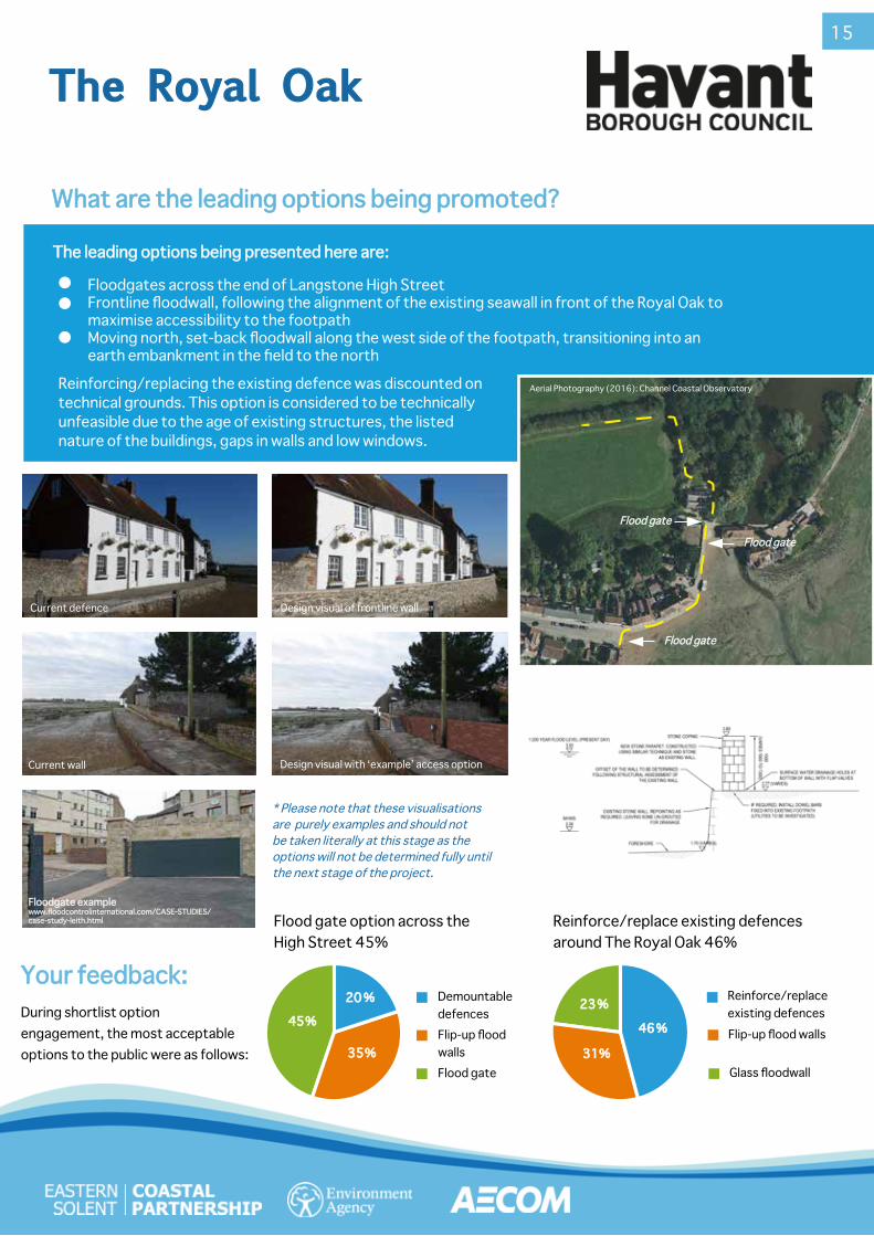
The Royal OakThe Royal Oak
What are the leading options being promoted?What are the leading options being promoted?
Your feedback:Your feedback:During shortlist option engagement, the most acceptable options to the public were as follows:
2200 %%
3355%%
4455%% 4466 %%
3311%%
2233 %%
Flood gate option across the High Street 45%
Reinforce/replace existing defences around The Royal Oak 46%
Demountable defencesFlip-up flood wallsFlood gate
Reinforce/replace existing defencesFlip-up flood walls
Glass floodwall
Floodgates across the end of Langstone High StreetFrontline floodwall, following the alignment of the existing seawall in front of the Royal Oak to maximise accessibility to the footpathMoving north, set-back floodwall along the west side of the footpath, transitioning into an earth embankment in the field to the north
The leading options being presented here are:The leading options being presented here are:
Floodgate exampleFloodgate examplewww.floodcontrolinternational.com/CASE-STUDIES/www.floodcontrolinternational.com/CASE-STUDIES/case-study-leith.htmlcase-study-leith.html
Current defence Design visual of frontline wall
Current wall Design visual with ‘example’ access option
* Please note that these visualisations are purely examples and should not be taken literally at this stage as the options will not be determined fully until the next stage of the project.
Flood gateFlood gate
Flood gateFlood gate
Flood gateFlood gate
Aerial Photography (2016): Channel Coastal ObservatoryReinforcing/replacing the existing defence was discounted on technical grounds. This option is considered to be technically unfeasible due to the age of existing structures, the listed nature of the buildings, gaps in walls and low windows.

16
What happens next?What happens next?
The detailed design stage of the project is likely to take 18-24 months.Whilst the principles of the scheme have been defined, following the technical guidance which governs our industry, there is at least another 2 years for these options to be refined, adapted and if necessary, changed through the detailed design process. This includes how they will look and feel with strong consideration of community views but of course within the wholly appropriate constraints of our regulators Natural England, Historic England, Chichester Harbour Conservancy, Langstone Harbour Board and the Local Planning Authority.
Detailed DesignDetailed Design
Community EngagementCommunity EngagementWe will carefully review all of the feedback from the public events and questionnaires to inform the next stage of the project.
Engagement with the stakeholder working group, residents, landowners, public and regulators will continue throughout the detailed design stage to refine and shape the leading options to ensure the project arrives at the best outcome.
Winter 2019/20:Winter 2019/20: Spring 2022/23:Spring 2022/23:Now:Now:Begin detailed designs Begin detailed designs
and investigate and investigate potential funding potential funding
partnerspartners
Public events -Public events -Leading optionsLeading options
Construction start Construction start (estimated)(estimated)
To see all engagement materials to date, please visit us To see all engagement materials to date, please visit us online at: www.escp.org.uk/langstoneonline at: www.escp.org.uk/langstone