lao mekong sanakham hydropower project introduction
TRANSCRIPT

1
Lao Mekong Sanakham Hydropower Project
introduction
Ministry of Energy and Mines
Department of Energy Policy and Planning
CONTENTS
✓ Design and investigation process
✓Project layout
✓ Design standards
✓ Project study

➢ Design and investigation process

➢ Design and investigation process
F/S for Peer Review complied with PDG 2009
The Updated F/S Report was finally acknowledged by Ministry of Energy and
Mines, Lao PDR.
The ESIA was approved by GoL
MOU signed in 2007

➢ Project Layout
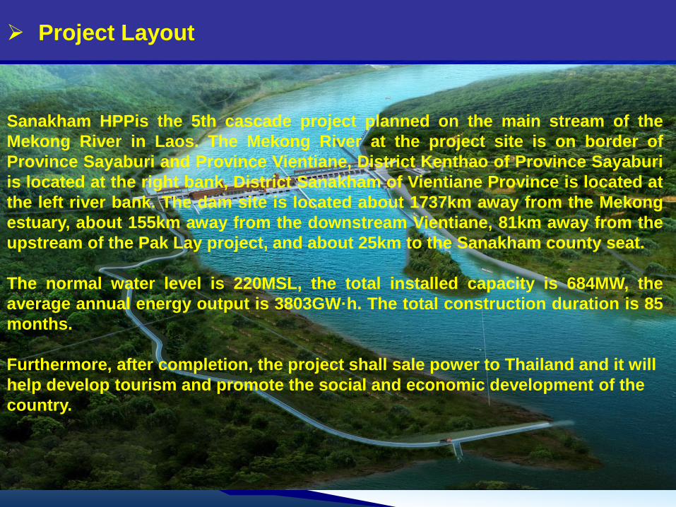
Sanakham HPPis the 5th cascade project planned on the main stream of the
Mekong River in Laos. The Mekong River at the project site is on border of
Province Sayaburi and Province Vientiane, District Kenthao of Province Sayaburi
is located at the right bank, District Sanakham of Vientiane Province is located at
the left river bank. The dam site is located about 1737km away from the Mekong
estuary, about 155km away from the downstream Vientiane, 81km away from the
upstream of the Pak Lay project, and about 25km to the Sanakham county seat.
The normal water level is 220MSL, the total installed capacity is 684MW, the
average annual energy output is 3803GW·h. The total construction duration is 85
months.
Furthermore, after completion, the project shall sale power to Thailand and it will
help develop tourism and promote the social and economic development of the
country.
➢ Project Layout

➢ Project Layout
Dam type: Concrete dam
Water retaining structure: Left auxiliary dam, ship lock, left flood sluice, powerhouse,
right flood sluice, fish pass, right auxiliary dam
Dam crest length: 909.9m
Max. dam height: 56.2m
Switchyard

Upstream view
➢ Project Layout
In order to improve sand flushing efficiency, the bottom elevation of the right four
outlets has been lowered to 192.0m, from 198.0m.
198
Powerhouse section unit block
1#~12# and erection bay
192
262.2 46 91.542250
Left bank flood sluice gate
13-15x22 (Normal) Right bank flood
sluice gate
4-12.5x16 (Lower)
1-12.5x22
(Normal)
Sluice outlet
6-2.5x4.5

➢ Design Standards

Updated FS Report is in compliance with following standards:
✓ Lao Electric Power Technical Standards;
✓ Preliminary Design Guidance for Proposed Mainstream
Dams in the Lower Mekong Basin, and related MRC
regulations;
✓ Periodic Technical Bulletins on the Safety of Dams issued
by the International Commission on Large Dams (ICOLD) ;
✓ World Bank, Operational Policy 4.37;
✓ International standard:ACI、ASTM、US Army Corps of
Engineers、United States Bureau of Reclamation,etc.
✓ China Power Industry Standard;
➢ Design Standards
➢ Project study
1. Hydrology
2. Sediment & Water quality
3. Dam safety
4. Navigation
5. Fish way
6. Resettlement
7. Transboundary study

⚫ 1. Hydrology
Hydrological data
➢ Project study
Previous FS Report Updated FS Report Latest Data
Run off data 1923~2004 1923~2019 1923~2019
Flood data 1923~2004 1923~2008 1923~2019
✓ During 2009~2019, 4 sets of water gauges
had been established at the damsite, mainly
to measure water levels;

Hydrological data gauges location
➢ Project study
P Water Gauge
A Water Gauge
DA
M A
XIS
B Water Gauge
C Water Gauge

Runoff
Jan. Feb. Mar. Apr. May Jun. Jul. Aug. Sep. Oct. Nov. Dec.Annua
lRemark
1680 1340 1150 1160 1670 3390 6860 11600 10900 6600 3840 2360 4400 This Review
(1923-2008)
1690 1340 1150 1160 1650 3420 6920 11800 10900 6570 3840 2350 4410
Feasibility
Study in 2011
(1923-2004)
1700 1360 1160 1160 1650 3430 6920 11800 10900 6590 3860 2360 4410 Latest Data
(1923-2019)
➢ Project study
It can be found that this review result of the long term monthly average
discharge is similar to the result of the feasibility study in 2011.

Flood
➢ Project study
Exceedance
Probability(%)T(years)
Flood Flows at Sanakham project
1994 Study
Estimations
NWE
Estimations
MRC-CNR
Estimations
50 2 16300 16200
20 5 19400 19000
10 10 23580 21300 21100
5 20 22900 23000
2 50 25000 25500
1 100 28780 28400 27200
0.5 200 29900 29000
0.2 500 31700
0.1 1000 33880 3310033000
(30900-34900)
0.05 2000 3440034700
(32500-36850)
0.02 5000 3610037000
(34550-39450)
0.01 10000 3730038800
(36150-41400)
It can been seen that the flood
calculation method adopted by NWE
is similar to the calculation method
adopted by MRC-CNR and the
difference between the developer
estimations and MRC-CNR
estimations is very small, the
maximum of which is less than
3.87%,the minimum is only 0.86%.

⚫ 2. Water quality and
Sediment sampling
• Taking samples twice per month.
➢ Project study

Calculation with mathematical model
Morphology for 2-D
water-sediment
mathematic model
simulation
➢ Project study

Physical Model Test in Chong Qing, P.R.C
➢ Project study
Integral Model Test Semi-Integral Model Test
Research scope of the model test is: 2.5Km from the upstream of the
dam site and 1.7 Km from the downstream of the dam site with the 1:100
of model test scale.
➢ Project study

➢ Project study

• No earthquake above 5 magnitude has ever occurred within
100km of the dam site in 553 years;
• Seismic safety evaluation had been completed by the
Earthquake engineering research institute of Yunnan (China);
• The horizontal seismic peak ground acceleration for standard of
design and check is 0.063g (ah) and 0.1g (ah), respectively.
⚫ 3. Dam safety
1. Earthquake safety
➢ Project study

Dam type
Work condition
Return period
(year)
Flood discharge
(m3/s)
Gravity
dam
Design flood 2000 34700
Check flood 10000 38800
The proposed maximum navigable water level for navigation structures is
based on 3-year frequency floods.
➢ Project study
• Flood Standard

• The envisaged second-stage ship lock arrangement and estimated cost are
included.
• Navigation design during construction period is included.
• Sanakham HPP will be operated for power generation at inflow rate without
consideration of reservoir capacity regulation and dead water level is
designed for multiple operation choices. Generally, the normal operation
level is maintained at EL.220.0m.
• The one-way lockage time:T=5 (entrance) + 2(lock closing) +10 (filling or water release) +2 (lock opening)
+4(exit) +5 (interval)=28 min<30min
⚫ 4. Navigation
➢ Project study

➢ Project study

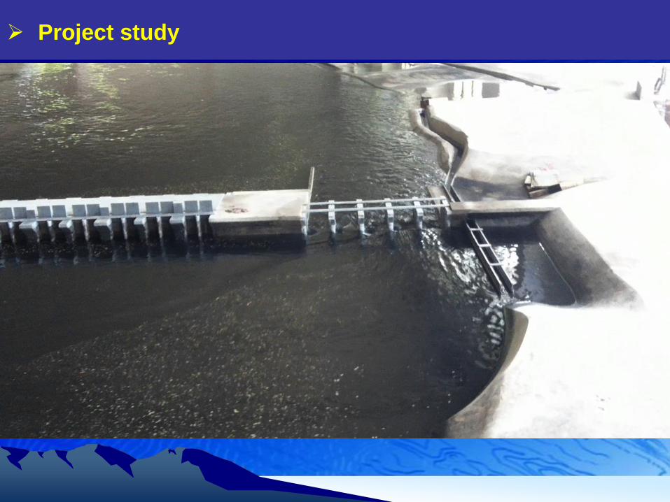
⚫ 5. Fish way
➢ Project study
With reference to the latest investigation on fish and historical data,
we studied the kinds, quantity of fish resource, and living habit.
And referring to the experience on the world, A natural-like fishway is
selected.

Passages for fish passing through Sanakham dam: fishway, turbine, sluice.
Turbine generators for Sanakham are bulb type units, which are environmental friendly.
With 18 flat-bottom flood sluices arranged for Sanakham, the upstream-downstream
level difference during the flood release period would be not much.
⚫ Fish way
➢ Project study

flood sluice gate section
powerhouse section
Fish pass
Width :5m;
Length:2.39km
Slope:0.075%
Switchyard
flood sluice gate section
Exit
Blocking fish with
electric screen
Entrance 1MEKONG
Namhueng
Entrance 2
➢ Project study
⚫ Fish way

➢ Project study

➢ Project study

➢ Project study
⚫ 6. Resettlement

➢ Project study
⚫ 7. Transboundary studyIn March 2013, company was entrusted
to initiate the Cumulative Impact
Assessment ("CIA") and Transboundary
Environmental Impact Assessment
("TEIA") of Sanakham hydropower
project. In September 2013, the TEIA
report and CIA report were submitted to
the Ministry of Natural Resources and
Environment and approved by the GoL.
In Aug 2017, the updated “CIA” & “TEIA”
were submitted to Ministry of Natural
Resources and Environment and
approved by the GoL.
Now developer hire external consultant
to collect data information regarding to
Thailand territory.

➢ Project study
Northwest Institute was invited to
cooperate with NCG to carry out the
physical index investigation of
Sanakham project. Meanwhile,
Northwest Institute studied hydrology,
fish migration and fishery, sediment
subsidence, navigation, water quality
and dam safety in cumulative and
transboundary impacts that The
National Mekong Committees
("NMCs") concerned. The results
show that the Sanakham project will
not have significant transboundary
and cumulative impacts on the above
areas.

➢ Project study
We have fully considered the concerns of the NMCs and invited the
Northwest Institute to conduct a detailed study on the above issues. At
present, no specific scheme has been formulated. We will invite the
Northwest Institute to offer detailed answers to relevant questions when the
PNPCA is initiated.
Thank you for your attention!