lateritic soils in distinct tropical environments
TRANSCRIPT
7/31/2019 Lateritic Soils in Distinct Tropical Environments
http://slidepdf.com/reader/full/lateritic-soils-in-distinct-tropical-environments 1/20
32. LATERITIC SOILS IN DISTINCT
TROPICAL ENVIRONMENTS:
Southern Sudan and Brazil
Mary McNeil
The myth of fertility of tropical soils is giving way before abundant evidence to the contrary.Many areas of the tropics have soils which are in a more or less advanced stage of natural lat-erization, which occurs when the soil is leached of silica, leaving residual minerals such asiron, aluminum, manganese and nickel. These widespread laterite-prone soils are usually cov-ered by rainforests or savannas. Most available organic matter is quickly reused by the living plants on such soils instead of forming a layer of humus. Thus, the soils are quickly impover-ished when forest or other plant cover is gone.
The southern Sudan and parts of Brazil have such laterite-tending soils, and the history of development projects in these areas exposes an almost complete disregard for the limits andconditions which such areas impose for productive development. In the Sudan, the peoples liv-
ing on laterite soils had developed their agriculture in harmony with the requirements of theland and practiced a shifting agriculture which allowed a long fallow period for rejuvenatingand preventing the loss of soils. Development projects have restructured traditional agriculturalstyles, often forcibly, resulting in overuse of the land, with consequent social and agriculturaldisasters. Other areas are threatened by a proposed canal to regulate the flow of the White Nileand conserve its waters. Studies indicate that the intimate and delicate relationship of the sur-rounding lands to the annual flooding would be disrupted, with consequent permanent destruc-tion of much of the grazing and farming land and possible serious problems for fishing.
7/31/2019 Lateritic Soils in Distinct Tropical Environments
http://slidepdf.com/reader/full/lateritic-soils-in-distinct-tropical-environments 2/20
592 THE CARELESS TECHNOLOGY
In Brazil, many thousands of hopeful pioneers have been lured into rain-forest areas of theAmazon basin and have cleared the forest for agriculture. Little thought had been given toadapting the type of agricultural practices and crops to the nature of the soil. As a result, thesoils have quickly become exhausted as the closed tree-soil-tree cycle has been destroyed. Inaddition, the minerals in the soil have tended to cake, producing a hard semi-desert over much
of the colonized areas. The colonizers have moved yet deeper into the forest trying to make ago of agriculture, but with the same results. A small group of Japanese colonists had the insightto plant useful trees; their example offers some hope for a nondestructive and realistic devel-opment of the area.
These case studies show how crucial it is for man to recognize all the many forces operatingwhen he tries to permanently modify the environment. The price paid in terms of an alteredecosystem must be worth what man gets in return. Survival of a small segment of humanity or a whole nation often depends upon how well we can distinguish between the real costs and real benefits of our development programs. With knowledge of the entire ecosystem involved, thesecosts and benefits can be better defined.
The myth of fertility of tropical soils which has been around since the days of Alexander vonHumboldt is slowly giving way. The lushnessof the tropical rain-forest has proven to be moreapparent than real. Close examination of large portions of these forests in Africa and SouthAmerica has shown them to be relics of a for-mer climatic regime: the so-called rain-forests
in many cases are subject to periods of little or no rainfall. Through clearing, construction andcultivation, man has disturbed the delicate bal-ances of relief and biology. In many instancesthese interferences have led to a rapid accelera-tion of the process of laterization.
We shall consider two widely separated ar-eas of the tropics, both ranging in vegetationfrom savanna to rain forest. The climate inthese rain-forested areas is closer to the sa-vanna type than to the true rain-forest. The se-lected regions are in northern South Americaand southern Sudan. The South American areacomprises three different locations within thevast Amazon region. Included are the savannasof Roraima which stretch from the province of Rio Branco, Brazil, into Guyana. Within thesesavannas are the laterite uplands. The secondlocation is the Bragantina region of the state of
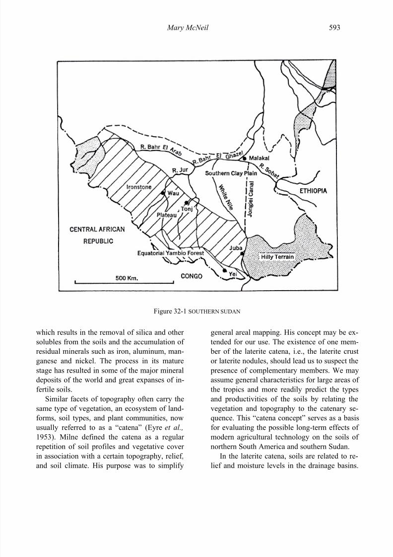
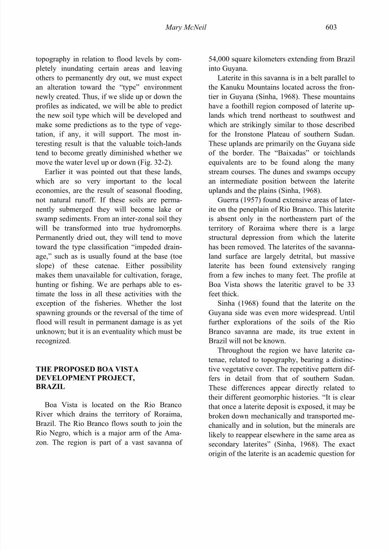
Pará in what was formerly true rain-forestedterrain; the final one is on the Amazon plains inthe territory of Guaporé, Brazil. Whereas theSouth American area is subdivided, the regionin southern Sudan is contiguous, with separate belts ranging from the Ironstone (laterite) Pla-teau in the south to the savannas along the Bahr el Ghazal River (see Fig. 32-1).
The case histories in this study show many parallels. Although geomorphologists have of-ten found comparisons of land forms valuableto their interpretation, it is not usual for thesecomparisons to include the man-land relation-ships in any great detail, nor is it usual to com- pare very widely separated areas.
In both northern South America and south-ern Sudan, the slopes tend to be more fertilethan the plateau surfaces, and indigenous popu-lations have long relied on them and the sea-sonally flooded lowland areas for food produc-tion. These slopes are easily eroded and must be skillfully worked.
The weathering process in these widelyseparated regions is one of laterization and isrepresented by many different stages. Lateriza-tion is the wearing down of the earth’s surface
7/31/2019 Lateritic Soils in Distinct Tropical Environments
http://slidepdf.com/reader/full/lateritic-soils-in-distinct-tropical-environments 3/20
Mary McNeil 593
Figure 32-1 SOUTHERN SUDAN
which results in the removal of silica and other solubles from the soils and the accumulation of residual minerals such as iron, aluminum, man-ganese and nickel. The process in its maturestage has resulted in some of the major mineraldeposits of the world and great expanses of in-
fertile soils.Similar facets of topography often carry thesame type of vegetation, an ecosystem of land-forms, soil types, and plant communities, nowusually referred to as a “catena” (Eyre et al., 1953). Milne defined the catena as a regular repetition of soil profiles and vegetative cover in association with a certain topography, relief,and soil climate. His purpose was to simplify
general areal mapping. His concept may be ex-tended for our use. The existence of one mem- ber of the laterite catena, i.e., the laterite crustor laterite nodules, should lead us to suspect the presence of complementary members. We mayassume general characteristics for large areas of
the tropics and more readily predict the typesand productivities of the soils by relating thevegetation and topography to the catenary se-quence. This “catena concept” serves as a basisfor evaluating the possible long-term effects of modern agricultural technology on the soils of northern South America and southern Sudan.
In the laterite catena, soils are related to re-lief and moisture levels in the drainage basins.
7/31/2019 Lateritic Soils in Distinct Tropical Environments
http://slidepdf.com/reader/full/lateritic-soils-in-distinct-tropical-environments 4/20
594 THE CARELESS TECHNOLOGY
In the areas dissected by erosion the crestal sur-faces are covered by a thin veneer of red soilssupporting forests, often no longer true rain-forest. Beneath this soil is a lateritic crust of varying thickness which, because of its resis-
tance to erosion, gives the hills a characteristicscarp. The slopes below the cap of laterite bear lateritic soils, characteristically reddish with boulders and nodules of lateritic debris. Theyare forested, but when cleared they provide themost arable of these lands. These soils are alsothe most subject to erosion in the form of sheetwash and gullying.
At the base or “toe slope” there are inter-zonal soils of grayish-red color, bordering the
hydromorphic or swamp soils because of theincrease in soil moisture (Bunting, 1965). The plains below these slopes, i.e., the basin areas,have true hydromorphic soils consisting of black clays. They are often peaty in nature dueto their high organic content.This sequence has a variant in those areas inthe South American forested plains wheregroundwater laterites are present below the sur-face. If we realize that these are the original
peneplained surfaces that have not been up-lifted and dissected, we may relate these later-ites to the crestal laterite crusts. It must be keptin mind that neither the lateritic crusts nor thesoils are end products, though the former aremore durable. Both are stages in the geomor- phic process itself.
The environment of this weathering processof laterization is an important variable. Climateis critical, especially the microclimate of themass being weathered. The amount and regimeof precipitation and run-off are important inlaterization since this process is one of leach-ing, though this is an oversimplification. Thenatural environment includes the biota withinand upon the physical mass. This organic com- plex is extremely important to the establish-ment of equilibrium through time.
The closed “plant-soil-plant” cycle of therain-forest, which is responsible for its con-tinuity and survival under conditions of ex-cessive soil leaching, is not easily re-established once broken. Eyre (1963) has
pointed out that deep weathering could so im- poverish the soils as to deprive root structuresof needed nutrients, even without human inter-vention in this environmental balance. Mostecologists have concluded, however, that hu-man endeavor has been most instrumental inthe retreat of the rainforests.
In northern Brazil, where the weathering process is farther advanced, massive exposedlaterites are fewer. Instead the mass has weath-
ered to laterite gravel, often formed into ridges.Where massive laterite occurs, however, it iswithin a few feet of the surface of the plateau,and as in Sudan, varies in thickness but is rarelyless than a few feet thick. This laterite can be broken up mechanically, but since most of thereadily soluble minerals have long since beenremoved, deposited detritus is very similar incomposition to the massive laterite. In Brazil,large areas of deposition of lateritic debris are
distributed by sheetwash on the lower slopesand onto the plains. Many of the plains are lit-erally paved with aggregations of this material,locally termed “canga.”
Both of the subject regions are characterized by laterite uplands which are, however, at dif-ferent stages in the weathering cycle: those of northern South America are far more dissectedand broken by erosion than those of southernSudan. There are hill remnants or Inselbergefound on the plains of Rio Branco Province,Brazil, but the greatest expression of these islocated across the frontiers in Guyana (Sinha,1968). The uplands of Roraima Province, Bra-zil, are similar in many respects to the Iron-stone Plateau of southern Sudan. The presenceof shale beds below the laterite in the Brazilian profiles, however, makes for a striking differ-ence in detail.
7/31/2019 Lateritic Soils in Distinct Tropical Environments
http://slidepdf.com/reader/full/lateritic-soils-in-distinct-tropical-environments 5/20
Mary McNeil 595
Southern Sudan and northern South Americahave many differences as well as similarities.One of the major differences is the length of thedry season. It is more humid in northern SouthAmerica; however, wholesale clearing of areas
has led to a lengthening of the dry season, witha lessening of the rates of precipitation(Ackermann, 1962).
THE SOUTHERN SUDAN
The southern Sudan is a vast, little known portion of Africa between 4° and 10° north lati-tude. The landscape is a very diverse one,
sparsely inhabited by many tribes. Ardrey(1967) states in African Genesis that “timid people tend to live at unfashionable addresses,”and this is certainly true of the tribes scatteredthrough the many inhospitable environments of the southern Sudan. The possible single excep-tion has been the Azande, who suffer thetrauma of the conquered conqueror. To survive,all these tribes have developed traditionalmethods of agriculture, hunting and fishing,
which are adaptive responses to the environ-ment.The whole area is only sparsely inhabited by
Nilotic and Central African tribes, essentiallyagriculturalists who have been competingamong themselves for the rare arable lands.Basinski (1957) speaks of the equilibrium withthe environment which has been established bythese people through trial and error. “Any revo-lution in these methods, unless well thought outand tested, may lead to deterioration rather than
improvement of agricultural output.”The key words here are “well thought out.”
We shall explore some of the instances wherethere has been either consideration or lack of itregarding ecological implications of develop-ment programs. In the cases where ecologicalstudies were made, we will note whether theinformation was included in the implementa-
tion phases and what the results are to date. Wewill also consider some of the programs stillenvisioned for the area.
THE JUR R IVER DISTRICT OF SOUTHERN
SUDAN In 1863, Dr. Theodore Kotschy described
the country we know today as the Jur River District around Wau as the “best of all those inthe Bahr-El-Ghazal.” The country offered“great advantages to the inhabitants by its soil being somewhat elevated, ferruginous and veryfertile” (Tothill, 1947, p. 35). Dr. Kotschy wasdescribing what we now call the Ironstone Pla-teau, the hills of which are flat-topped and of
massive laterite, which outcrops throughout thearea. The ridge of this plateau now supports theall-weather road from Wau to Tonj.
On closer inspection these “very fertile”soils show evidence of widespread erosion of the thin veneer of lateritic loams which have been extensively worked by the Jur tribes in atraditional system of shifting cultivation.
All this region and more of the IronstonePlateau is covered by savanna-type vegetation
composed of a largely fire climax genre. Of thesome 28% of the Ironstone Plateau countryconsidered to be “middle level” in terms of slope, a sizable amount is not cultivatable dueto distances from water supplies, shallownessof soils, outcrops of ironstone laterite, presenceof stumps and tribal conflicts of ownership.Thus, we have people widely scattered on the“good sites,” which have been carefully se-lected and distributed in an equally careful
manner by the tribes. An estimate of 10% of the plateau as suitable for cultivation may well behigh.
The system of cultivation used by the Jur limited agriculture to the gentlest slopes, thuslimiting the man-made erosion in the area (Eyreet al., 1953). In order to have ready access towater, these people settled in the areas of the permanent streams. The Jur River district has
7/31/2019 Lateritic Soils in Distinct Tropical Environments
http://slidepdf.com/reader/full/lateritic-soils-in-distinct-tropical-environments 6/20
596 THE CARELESS TECHNOLOGY
many broad stream valleys which frequently become waterlogged in the flood season.Therefore, the Jur selected the middle-levelslopes for their fields. They usually croppedtheir lands for five to eight years and then let
them lie fallow for twenty to thirty years. For its rotation, this traditional system requiredsome 17 hectares per family to permit sub-sistence.
In 1953, Eyre et al. recommended an elabo-rate ecological survey of the Jur River district,since the evidence at that time indicated thatthere was little agricultural land in the areawhich was not already incorporated in the clansystem of the Jur and cultivated. Such a survey
has not yet been made, in part due to the condi-tions of civil war which have prevailed in theregion since 1956.
Resettlement programs sponsored by thegovernment have brought havoc to the tra-ditional systems of rotation. Instead of re-ceiving recognition for the enormous adjust-ments they have made to subsist, the Jur have been summarily uprooted and forced into stripsettlements, primarily to make problems of
civic administration easier. This has inevitablyresulted in a reduction of the productivity of thearea, and an additional burden has been placedon the carrying capacity of the land.
The opening of the Jur River district by theextension of Sudan Railways, which now ter-minates in Wau, has served to further increasethe pressures on the land. The total pressureexerted on the Jur is such that unless some re-evaluation is made, the 1980’s will find a popu-lation which will be unable to sustain itself.
THE ZANDE1 SCHEME OF
SOUTHERN SUDAN
The Azande2 occupy a district of the Sudanalong the Nile-Congo Divide in an estimated
1 Zande—term used for nation.
area of 54,000 square kilometers. This Zandecountry is largely a tropical forested area. Zan-deland is composed of the higher portions of the Ironstone Plateau, which receives a greater annual precipitation than the Jur River district
to the north. It is more densely covered with bush and forest. A greater percentage of thearea is covered by woodlands recently derivedfrom rain-forest but there are still patches of true rain-forest vegetation.
McCall and Wilson (1954) summarize theregion: “Zandeland is therefore not a land of milk and honey where an easy livelihood can be gained without real effort. The soils are not particularly fertile and can speedily become
unproductive if great care in their cultivation isnot exercised. Food or cash crop production isnot easy and is limited by the difficulties of cul-tivating in thick bush country with poor imple-ments, poor health and a lack of any real desireto produce more than the bare necessities of life.”
The Azande people in the Sudan representonly a portion of the entire Zande nation whichcrosses into the Congo and the Central African
Republic. The latest population figures for theAzande give an estimate of over 180,000 peo- ple in the Sudan. As is common in Africa, thearbitrarily established boundaries have greatlydisturbed the nation. Until the time of theEuropean invasions, the power of conquest andassimilation was in the hands of the Azande.The Zande nation was then the dominant cul-tural influence in this part of Africa.
The freedom of the Azande has been greatlycurtailed and they have been “compelled togive up their traditional mode of territorial dis-tribution and live herded together in settlementswhich they abominate” (Evans-Pritchard,1931b, p. 146). This “herding” began as far back as 1922 when the colonial administration
2 Azande—term used for people.
7/31/2019 Lateritic Soils in Distinct Tropical Environments
http://slidepdf.com/reader/full/lateritic-soils-in-distinct-tropical-environments 7/20
Mary McNeil 597
forced them into settlements along the roads inefforts to control sleeping sickness amongthem. The roads were built along the ridgeswhich are relatively free from the tsetse flieswhich abound in the valley bottoms. The
Azande have been moved three times since thatfirst resettlement, always as a result of govern-mental orders. One of the main difficulties withthe Zande Scheme for agricultural developmenthas been this disregard for the residential pref-erences of the Azande (Wanji, personal com-munication).
As part of an attempt to introduce cash-cropping to the district, the Zande Schemeopened in the 1940’s with the commissioner
resettling five thousand homesteads in theYambio area. The theory was that the cotton- producing scheme would be more successful if the supervision were easier. Although the ra-tionale for this effort was supervision of thecash crop, ultimately fifty thousand familieswere resettled, almost the entire population. Anexamination of the evidence surrounding thiswholesale redistribution of people seems toshow that there have been a number of mis-
placed good intentions involved and very littlereal knowledge of the ecology of the Azande.Professor Reining (1966) found that the
“Azande regarded themselves as good and in-dustrious agriculturalists, able to choose the best land and knowing the various requirementsfor their various crops. They practiced what isusually referred to as shifting cultivation, in-volving the clearing of forests for small fieldsthat were useful only for two to four years after which they had to be allowed to regenerate thenatural vegetation.”
Reining (1966) set out to discover why theAzande became disenchanted when they hadoriginally been enthusiastic about the develop-ment program. The scheme, which beganshortly after World War II, had been evolvedfrom the original proposals of Dr. Tothill, whosurveyed the Equatorial Region in the thirties.
He suggested that there might be developmentof agriculture, transport and internal trade andthat cotton would be suitable and profitable.
Dr. Tothill followed up his original proposalto the Ministry of Agriculture with some more
specific recommendations. His plans were to bring the Azande from subsistence to a state of community self-sufficiency in view of the re-moteness of the area (Tothill, 1948). The enter- prise called for a vertically integrated operationof cotton production with the finished cloth to be sold on the Khartoum market. Export fromthe region was to consist of cotton, palm oil, jute and coffee. There was to be concomitantindustry for sugar, charcoal, timber and iron, all
for local consumption. This scheme was veryquickly emasculated by the various committeescharged with its feasibility, the end result beingone crop for cash—cotton. The evils of mono-culture were not considered.
The cotton crop was a success for the firstfew years and the yields were high, but after three years of operation the production droppedoff markedly. Force was then applied to attainthe desired production levels and the Azande
became plantation “peons” instead of the primeactors in a great drama of the advance out of the Neolithic Age. From this point on, thescheme deteriorated in terms of its original ob- jective of self-sufficiency.
What is of special importance is what hap- pened to man’s relationship to the land and itscapability to provide for him. The cotton cropreached over eight million pounds by 1950.With cotton prices high, planting expandedwell into land which ecologists had declaredunsuitable. Since settlement expanded with theexpanding acreages, there were homesteads onmarginal lands, and these homesteads weresoon without their promised cash crop. The ex-ecutors of the Zande Scheme chose to ignorethe information which had been provided tothem by an ecological survey made prior to theinstitution of the Zande Scheme. Ferguson
7/31/2019 Lateritic Soils in Distinct Tropical Environments
http://slidepdf.com/reader/full/lateritic-soils-in-distinct-tropical-environments 8/20
598 THE CARELESS TECHNOLOGY
(1954), in reviewing the available information,described Zandeland as a “problem region” ly-ing between the equatorial forest and the sa-vanna, with a limited potential for the produc-tion of plantation crops.
The present family holding is roughly 14hectares, allowing for a fixed grass rotation sys-tem to develop, a form of bush fallow thought by the designers of the scheme to be sufficientfor the infertile soils. Strip cropping was intro-duced to control erosion to which these lateriticsoils are susceptible. But strip cropping was notcarried out properly. The “close supervision”which was made so much of as a part of theZande Scheme broke down and the cultivators
did not maintain the ten years’ fallow required by the system. The length of the fallow periodwas selected as a minimum requirement. Wehave seen earlier that traditional systems of ro-tation gave twenty to thirty years for fallow, afigure arrived at empirically.
The capability of the soils to replenish them-selves varies widely with the grass length andtime of fallow. Ferguson (1954) notes that thesoil “might not adequately maintain fertility in
perpetuo or [for agriculture to] be possible atall if the population were to increase.” To re-generate soil fertility, “bush fallow must be suf-ficiently long to permit the growth of deeprooted species which mine the nutrients fromdeeper soil levels and deposit them in the formof litter on the soil surface” (Basinski, 1957).
Besides the length of fallow, there are other problems besetting production in the ZandeScheme. The increase of the cotton pests withexpansion of cotton production has been diffi-cult to deal with. Perhaps the greatest problemof all, however, is the control of bush fires.These frequently become so hot that they de-stroy the surface layers of the soils as well asthe vegetative cover. These fires have beensteadily increasing in number and extent with population growth in the area.
Changes in climate are occurring as clear-ings of the bush by fire and cultivation con-tinue, resulting in a lengthening of the dry sea-son and an increase of the “derived” savannawith permanent destruction of the forested ar-
eas. Morrison et al. (1948) describe a profilefrom the Yei area taken halfway down-slope ona typical hill of this Ironstone Plateau, the crestof which had the usual ironstone cap. Theyfound a thick horizon of pea iron with intermix-tures of blocks of iron. The area was channeled by termites, and the channels in turn had ironoxide around them due to fluctuations in thewater table; the iron apparently precipitated inthe dry season. These authors theorize that the
“ironstone sheet” was once part of the subsoiland hardened when exposed by erosion. Thesubsequent drying out of the mass resulted inthe irreversible separation of the iron.
THE AWEIL R ICE PROJECT AND THE TOICHLANDS OF SOUTHERN SUDAN
Where drainage becomes seriously impeded by changes in slope and contour, the fringingand gallery forests are replaced by open grass-
land known as toich (Smith, N.D., p. 19).Along the frontier where the Ironstone Plateauis in abrupt contact with the Clay Plains or the“toe slope” of the catena, we find extensivetoichlands. These toichlands join the IronstonePlateau at about the 418 meter contour abovesea level. Other toichlands are found along theWhite Nile. Morrison et al. (1948) made anecological study of the tropical lateritic claysand vegetation of these seasonally flooded ar-
eas.The distinguishing feature of these toich-lands is that they are flooded by the overspill of the rivers and remain under water many monthsof the year. They are not the result of floodingfrom runoff in the rainy season, which wouldresult only in intermittent water-logging. Be-cause of their higher organic content, the toich-lands are among the more fertile soils of the
7/31/2019 Lateritic Soils in Distinct Tropical Environments
http://slidepdf.com/reader/full/lateritic-soils-in-distinct-tropical-environments 9/20
Mary McNeil 599
southern Sudan. The usual use of the toichlandsin the dry period is for cattle grazing. Cultiva-tion of these lands is very sporadic due to thenatural reluctance on the part of the populationto accept the role of farmer and the difficulties,
especially drainage problems.Sudan is an importer of rice and, as changes
in custom have been occurring, rice consump-tion in the country has been increasing. After many trials, the natural conditions aroundAweil, Bahr el Ghazal Province, appeared tothe Ministry of Agriculture to be the best inSudan for the production of rice. The Ministrydecided on a series of pilot projects in theAweil area which confirmed the earlier trials.
Increases in world prices of rice became an ad-ditional spur and the Aweil Toich Rice Projectwas initiated in 1954 (Hakim, 1963).
The Aweil Toich parallels the river Lol andis about 35,000 hectares in size. By 1963, about500 hectares were under rice cultivation. The project has been considered successful by theGovernment and there have been plans to bringthe acreage up to 4,000 hectares, sufficient tosupply the Sudanese demand for rice.
There seems to be little doubt that the area issuited for rice production, but some of the cul-tural practices used on the Aweil Toich bear careful scrutiny. Mechanization has been intro-duced to the scheme, and as yet its effect onsoil structure is unknown. Dikes have beenconstructed, and more will be, to control thewater in the additional acreages. This practicetends to limit new silting of the soils which isone of the ways in which the soils are enriched
by a natural regeneration in necessary nutrients.According to Hakim (1963), no land is to beleft fallow nor is there to be another crop in ro-tation with the rice. The Senior Inspector of theAweil Rice Project feels that the heavy weedgrowth that would result on fallow land wouldmake the project uneconomic. No fertilizerswhatever are used. Declining yields are blamedon excessive flooding, which may or may not
be the critical factor. It seems logical to assumethat cultural practices such as these will inevi-tably lead to a decline in yields. Since there will be no regenerative silting and constant floodingwill cause a transition to swamp soils, these
lands will become unproductive.If the purpose of the project is to improve
the standard of living of the Dinka of the area,it has its drawbacks in that the Dinka are tradi-tionally cattle people, and these toichlands have been their grazing lands. Few Dinka wish to befarmers, and few will work for wages. There-fore, the scheme is plagued with labor prob-lems, and rice is a labor-intensive crop. Mean-while, the people must search out new grazing
areas.The Aweil Rice Project is neither an eco-
nomic nor a social success. The savings in for-eign exchange are a mirage in view of costs of production and the capital investment, whichmight have been better employed elsewhere.The costs of cultivation presently not included,such as rotation, weeding and fertilizers, should be added. This accounting would show the do-mestic rice to be much more expensive than the
imported article. Under the present cultivation plan, the life of the project will be limited, andit will be years before these lands will again beusable for grains, forage crops and grazing,unless the changes brought about by diking can be reversed.
THE JONGLEI CANAL PROJECT,SOUTHERN SUDAN
Sir William Garstin in 1904 conceived the
idea of conserving the waters lost throughevaporation and transpiration in the Sudd of southern Sudan. The Equatorial Nile Project,which is the name given to the Victoria-Albert-Jonglei Scheme, was designed not only to save part of the water now lost but to regulate com- pletely the flow of the Nile.
7/31/2019 Lateritic Soils in Distinct Tropical Environments
http://slidepdf.com/reader/full/lateritic-soils-in-distinct-tropical-environments 10/20
600 THE CARELESS TECHNOLOGY
The proposed Jonglei Canal would be a se-ries of cuts through the Sudd to a point near Malakal at the mouth of the Sobat River, a dis-tance of 280 kilometers. Their purpose would be to increase the average flow of the White
Nile while reducing the variability of the flow.The Sudd is one of the largest and most im-
portant swamps in Africa. It is built on aninland delta with its apex at Mongalla and its base from Lake No to the Sobat River (Glennie,1957). This is an area of about 8,000 squarekilometers, which the Jonglei would delimit(Debenham, 1954). Some estimates have beenmade that the total area which would remain asswamp would be 1,000 square kilometers. This
swamp has served for thousands of years as anatural relief valve for the lower Nile and savedSudan and Egypt from many a disastrous flood.It is also a spawning ground for fish and affordsthe toichlands a natural flood irrigation, makingagriculture possible.
The seasonality of the Nile in this region isits most distinguishing characteristic and is of primary importance to both man and animals between Mongalla and Malakal. The banks of
the Nile are above the surrounding countrysidenorth of Jonglei, and when the river is in flood,its waters overspill these banks and spread outover the almost flat plain. Of the 27 billion cu- bic meters entering at Mongalla, it has been es-timated that 14 billion, more than half, are lostin the Sudd.
The Colonial Sudanese Government in 1946was aware of the potential disruption which the project might create and, therefore, set about todetermine the magnitude of the problem. Theyestablished the Jonglei Investigation Teamwhich reported on their findings in 1954. Theteam was charged with determining the effectson the regime of the Nile on agriculture, graz-ing, fisheries, people and other problems re-lated to engineering alternatives (Howell,1954).
The area to be surveyed by the teamstretched from Nimule on the Uganda border toKosti, a distance of 1,625 kilometers on the Nile. The directly affected area is estimated at300,000 square kilometers. No estimates, much
less studies, have been made of the indirectlyaffected areas.
The team found that the first need was for further research, or that the effects of this pro- posed Jonglei Canal were still somewhat un-known (Barbour, 1961). They recognized theneed for the “nutritive pasture” provided by the Nile and that changes in the “ecological charac-teristics of the flood-plains” would result. Intheir report they carefully discuss potential
changes in the Nile, reach by reach. In terms of actual pasture lost, estimates were given at 35%as best guesses. No real estimates could begiven of fisheries lost, although an assumptionwas tacitly made that the fish would adapt tothe complete reversal of the regime of the river in some of its reaches. On the effects on spawn-ing, which is intimately related to flood cyclesin the toich, no real prognosis could be given.An assumption was made, however, that intro-
duced commercial fisheries could make accept-able substitution for the losses.The Nilotic tribes of the region are “mi-
nutely related to the existing regime of theBahr-El-Jebel and other rivers of the region”(Barbour, 1961). These people rely completelyon the pasture formed in these toiches in thedry season, since the pasture away from theswamp areas which they use during the flood period becomes valueless as fodder once therains subside. The existence of the Sudd pas-tures is also dependent upon the floods.Barbour (1961) again states the situation well:“If no remedial steps were taken ... the effect of the Jonglei Canal would be to destroy the live-lihood of many of the Nilotes and completelyalter their way of life which is intimately re-lated to the keeping of cattle.”
7/31/2019 Lateritic Soils in Distinct Tropical Environments
http://slidepdf.com/reader/full/lateritic-soils-in-distinct-tropical-environments 11/20
Mary McNeil 601
These people, numbering some 700,000 in1954, have developed a rhythm of life in tunewith the floods on the Nile. They move to highground in the rainy period of April to Decem- ber and return to the riverain lands in the dry
period to graze their cattle, grow a few crops,fish and hunt. The five months spent on thefloodlands provide for their cattle when natu-ral forage on the uplands becomes inedible.
The Jonglei Canal Scheme would destroythis rhythm of life by making these flood-lands unavailable at just those times of year when they are most necessary. The seasonalityof the river itself would be altered. The floodswould cease to invade their former areas in
part of the Sudd, and soil and vegetationchanges would be inevitable. In other parts of the Sudd, the area would be permanentlyflooded and valuable lands permanently lost.
Morrice and Winder of the InvestigationTeam stated:
“It would be an exaggeration to say that all peoples in this area rely exclusively on animalhusbandry as a source of livelihood, for raingrown crops are of great importance in their
subsistence economy. Yet the production of grain crops is on the whole a precarious under-taking. In this region the mean annual rainfallis usually adequate, but its monthly distribu-tion is extremely variable. Moreover in most parts the soil is heavy and impermeable, theslope is exceptionally small, and the drainagesystem often inadequate to carry away the ac-cumulations of rainfall. In the early months of the wet season there is sometimes so little rain
that the newly planted crops perish fromdrought, whereas later in the year they may bedamaged by torrential storms or drowned byheavy flooding. The very laborious processesof crop production for these reasons are cut toa minimum and the people rarely attempt togrow more grain than would be sufficient to
meet their own needs were they successful.Cattle and other animal stock are therefore of paramount importance because they providethe only reliable alternative to crop husbandry.Peoples in all parts of this area also rely on
fish to supplement their diet and fish are usu-ally available in large quantities in the poolsand lagoons on the flood plain of the Nile.”(Howell, 1954).
The assumed effects on topography and cli-mate were considered negligible in general buteffective on the microscale. The cessation of seasonal inundation and, hence, seasonalanaerobic conditions will result in the oxida-tion of a considerable proportion of the or-
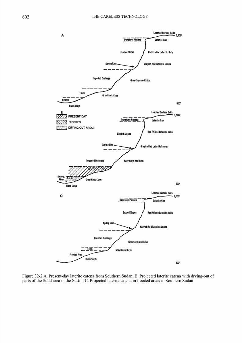
ganic matter in the soils (Howell, 1954). Theinvestigation team therefore expected a loss of fertility in the toich soils. In all probability theactual soil type would in very few years be soaltered that the toich would be obliterated insome areas and greatly reduced in others. Itwould be possible to predict the probable ex-tent of this destruction by careful mapping of the present toichlands in relation to the pro- posed engineering design.
Soil mosaics, such as found in southern Su-dan and described by Morrison et al. (1948)are related to the stage of relief and dissectionof the topography. The soils may vary some-what with the lithology but, certainly in thecase of the lateritic soils, the parent rock is notthe decisive factor. We can expect, therefore,to find the catenary sequences; such sequenceshave been described by Morrison and by theJonglei Investigation Team. Although non-
catenary sequences of soils will be found inthe area, the concept will highlight the edaphicchanges which will result with the imple-mentation of the Canal Project. It should berealized that individual soil profiles will reactindividually.
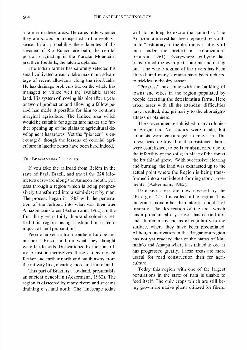
Figure 32-2A shows a generalized picture
7/31/2019 Lateritic Soils in Distinct Tropical Environments
http://slidepdf.com/reader/full/lateritic-soils-in-distinct-tropical-environments 12/20
602 THE CARELESS TECHNOLOGY
Figure 32-2 A. Present-day laterite catena from Southern Sudan; B. Projected laterite catena with drying-out of parts of the Sudd area in the Sudan; C. Projected laterite catena in flooded areas in Southern Sudan
7/31/2019 Lateritic Soils in Distinct Tropical Environments
http://slidepdf.com/reader/full/lateritic-soils-in-distinct-tropical-environments 13/20
Mary McNeil 603
topography in relation to flood levels by com- pletely inundating certain areas and leavingothers to permanently dry out, we must expectan alteration toward the “type” environment
newly created. Thus, if we slide up or down the profiles as indicated, we will be able to predictthe new soil type which will be developed andmake some predictions as to the type of vege-tation, if any, it will support. The most in-teresting result is that the valuable toich-landstend to become greatly diminished whether wemove the water level up or down (Fig. 32-2).
Earlier it was pointed out that these lands,which are so very important to the local
economies, are the result of seasonal flooding,not natural runoff. If these soils are perma-nently submerged they will become lake or swamp sediments. From an inter-zonal soil theywill be transformed into true hydromorphs.Permanently dried out, they will tend to movetoward the type classification “impeded drain-age,” such as is usually found at the base (toeslope) of these catenae. Either possibilitymakes them unavailable for cultivation, forage,hunting or fishing. We are perhaps able to es-timate the loss in all these activities with theexception of the fisheries. Whether the lostspawning grounds or the reversal of the time of flood will result in permanent damage is as yetunknown; but it is an eventuality which must berecognized.
THE PROPOSED BOA VISTA
DEVELOPMENT PROJECT,
BRAZIL
Boa Vista is located on the Rio BrancoRiver which drains the territory of Roraima,Brazil. The Rio Branco flows south to join theRio Negro, which is a major arm of the Ama-zon. The region is part of a vast savanna of
54,000 square kilometers extending from Brazilinto Guyana.
Laterite in this savanna is in a belt parallel tothe Kanuku Mountains located across the fron-
tier in Guyana (Sinha, 1968). These mountainshave a foothill region composed of laterite up-lands which trend northeast to southwest andwhich are strikingly similar to those describedfor the Ironstone Plateau of southern Sudan.These uplands are primarily on the Guyana sideof the border. The “Baixadas” or toichlandsequivalents are to be found along the manystream courses. The dunes and swamps occupyan intermediate position between the laterite
uplands and the plains (Sinha, 1968).Guerra (1957) found extensive areas of later-ite on the peneplain of Rio Branco. This lateriteis absent only in the northeastern part of theterritory of Roraima where there is a largestructural depression from which the lateritehas been removed. The laterites of the savanna-land surface are largely detrital, but massivelaterite has been found extensively rangingfrom a few inches to many feet. The profile atBoa Vista shows the lateritic gravel to be 33feet thick.
Sinha (1968) found that the laterite on theGuyana side was even more widespread. Untilfurther explorations of the soils of the RioBranco savanna are made, its true extent inBrazil will not be known.
Throughout the region we have laterite ca-tenae, related to topography, bearing a distinc-tive vegetative cover. The repetitive pattern dif-fers in detail from that of southern Sudan.
These differences appear directly related totheir different geomorphic histories. “It is clear that once a laterite deposit is exposed, it may be broken down mechanically and transported me-chanically and in solution, but the minerals arelikely to reappear elsewhere in the same area assecondary laterites” (Sinha, 1968). The exactorigin of the laterite is an academic question for
7/31/2019 Lateritic Soils in Distinct Tropical Environments
http://slidepdf.com/reader/full/lateritic-soils-in-distinct-tropical-environments 14/20
604 THE CARELESS TECHNOLOGY
a farmer in these areas. He cares little whether they are in situ or transported in the geologicsense. In all probability these laterites of thesavanna of Rio Branco are both, the detrital portion originating in the Kanaku Mountains
and their foothills, the laterite uplands.The Indian farmer has carefully selected his
small cultivated areas to take maximum advan-tage of recent alluviums along the riverbanks.He has drainage problems but on the whole hasmanaged to utilize well the available arableland. His system of moving his plot after a year or two of production and allowing a fallow pe-riod has made it possible for him to continuemarginal agriculture. The limited area which
would be suitable for agriculture makes the fur-ther opening up of the plains to agricultural de-velopment hazardous. Yet the “pioneer” is en-couraged, though the lessons of colonial agri-culture in laterite zones have been hard indeed.
THE BRAGANTINA COLONIES
If you take the railroad from Belém in thestate of Pará, Brazil, and travel the 228 kilo-meters eastward along the Amazon mouth, you pass through a region which is being progres-sively transformed into a semi-desert by man.The process began in 1883 with the penetra-tion of the railroad into what was then trueAmazon rain-forest (Ackermann, 1962). In thefirst thirty years thirty thousand colonists set-tled this region, using slash-and-burn tech-niques of land preparation.
People moved in from southern Europe andnortheast Brazil to farm what they thought
were fertile soils. Disheartened by their inabil-ity to sustain themselves, these settlers movedfarther and farther north and south away fromthe railway line, clearing more and more land.
This part of Brazil is a lowland, presumablyan ancient peneplain (Ackermann, 1962). Theregion is dissected by many rivers and streamsdraining east and north. The landscape today
will do nothing to excite the naturalist. TheAmazon rainforest has been replaced by scrub,mute “testimony to the destructive activity of man under the pretext of colonization”(Gourou, 1961). Everywhere, gullying has
transformed the even plain into an undulatingone. The whole regime of the rivers has beenaltered, and many streams have been reducedto trickles in the dry season.
“Progress” has come with the building of towns and cities in the region populated by people deserting the deteriorating farms. Hereurban areas with all the attendant difficultieshave resulted, due primarily to the shortsight-edness of planners.
The Government established many coloniesin Bragantina. No studies were made, butcolonists were encouraged to move in. Theforest was destroyed and subsistence farmswere established, to be later abandoned due tothe infertility of the soils; in place of the forestthe brushland grew. “With successive clearingand burning, the land was exhausted up to theactual point where the Region is being trans-formed into a semi-desert forming stony pave-
ments” (Ackermann, 1962).Extensive areas are now covered by the
“Pará gres,” as it is called in the region. Thismaterial is none other than lateritic nodules of limonite. The desiccation of the area whichhas a pronounced dry season has carried ironand aluminum by means of capillarity to thesurface, where they have been precipitated.Although laterization in the Bragantina regionhas not yet reached that of the states of Ma-
ranhão and Amapá where it is mined as ore, ithas progressed greatly. These areas are moreuseful for road construction than for agri-culture.
Today this region with one of the largest populations in the state of Pará is unable tofeed itself. The only crops which are still be-ing grown are native plants utilized for fibers.
7/31/2019 Lateritic Soils in Distinct Tropical Environments
http://slidepdf.com/reader/full/lateritic-soils-in-distinct-tropical-environments 15/20
Mary McNeil 605
Yields are diminishing yearly, and some of thelands devoted to this culture have ceased to produce.
The laterization process here has taken aboutfifty to seventy years to produce a semi-desert.
No records have been kept for us to actually pinpoint the time, which for a given acreage issurely shorter.
THE PRESIDENT DUTRA (IATA)
COLONY, BRAZIL
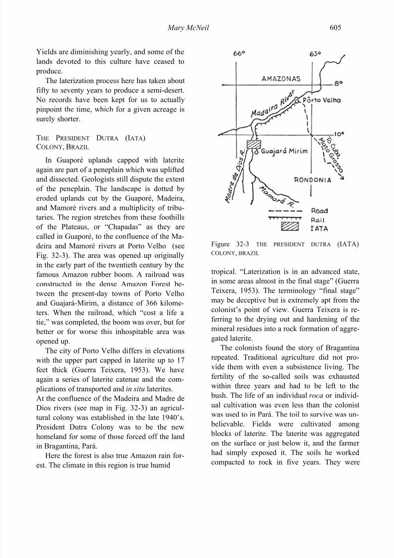
In Guaporé uplands capped with lateriteagain are part of a peneplain which was upliftedand dissected. Geologists still dispute the extentof the peneplain. The landscape is dotted by
eroded uplands cut by the Guaporé, Madeira,and Mamoré rivers and a multiplicity of tribu-taries. The region stretches from these foothillsof the Plateaus, or “Chapadas” as they arecalled in Guaporé, to the confluence of the Ma-deira and Mamoré rivers at Porto Velho (seeFig. 32-3). The area was opened up originallyin the early part of the twentieth century by thefamous Amazon rubber boom. A railroad wasconstructed in the dense Amazon Forest be-
tween the present-day towns of Porto Velhoand Guajará-Mirim, a distance of 366 kilome-ters. When the railroad, which “cost a life atie,” was completed, the boom was over, but for better or for worse this inhospitable area wasopened up.
The city of Porto Velho differs in elevationswith the upper part capped in laterite up to 17feet thick (Guerra Teixera, 1953). We haveagain a series of laterite catenae and the com-
plications of transported and in situ laterites.At the confluence of the Madeira and Madre deDios rivers (see map in Fig. 32-3) an agricul-tural colony was established in the late 1940’s.President Dutra Colony was to be the newhomeland for some of those forced off the landin Bragantina, Pará.
Here the forest is also true Amazon rain for-est. The climate in this region is true humid
Figure 32-3 THE PRESIDENT DUTRA (IATA)COLONY, BRAZIL
tropical. “Laterization is in an advanced state,in some areas almost in the final stage” (Guerra
Teixera, 1953). The terminology “final stage”may be deceptive but is extremely apt from thecolonist’s point of view. Guerra Teixera is re-ferring to the drying out and hardening of themineral residues into a rock formation of aggre-gated laterite.
The colonists found the story of Bragantinarepeated. Traditional agriculture did not pro-vide them with even a subsistence living. Thefertility of the so-called soils was exhaustedwithin three years and had to be left to the bush. The life of an individual roca or individ-ual cultivation was even less than the colonistwas used to in Pará. The toil to survive was un- believable. Fields were cultivated among blocks of laterite. The laterite was aggregatedon the surface or just below it, and the farmer had simply exposed it. The soils he workedcompacted to rock in five years. They were
7/31/2019 Lateritic Soils in Distinct Tropical Environments
http://slidepdf.com/reader/full/lateritic-soils-in-distinct-tropical-environments 16/20
606 THE CARELESS TECHNOLOGY
really not soils at all but residual mineralsmixed with the organic materials of the forest.When these were exhausted or leached by theheavy rains, the settler was left with only theresidue.
THE JAPANESE COLONY AT TOMÉ AÇU
A small ray of hope for man’s adaptation tothe laterite zones can be found in the successfulJapanese colony at Tomé Açu on the River Acará-Mirim south of Bragantina. These peoplereplaced the forest species with tree crops, par-ticularly the black pepper. Their success both in productivity and soil conservation is beginningto have a salutary effect on the Bragantina re-
gion itself, where their example is being emu-lated today. Some efforts to produce other treecrops in the region, among them rubber trees,are beginning to prosper. Much of the regionhas been ruined, however, and must wait untilstructural rejuvenation for the surface lateritesto be eroded off or until technology finds a wayto remove them mechanically.
CONCLUSION
We note that there are areas which are morefertile than others. We can generally relatethese to relief as we could in southern Sudan. Inthe vicinity of Iata and the city of Porto Velhoat the confluence of the Madeira-Mamoré thesoil mantle is thicker on the slope sides. When profiles are cut, we find, as we did at Yei inSudan, that the laterites are exposed beneath the
mantle; thus these highly erodable slope sidesrequire great care for their preservation. Theexcessive leaching in Guaporé makes their use-fulness limited since the nutrients were mereremnants of the forest which was removed andthese are quickly carried off in solution.
Camargo (1942) called the “great error” of colonizing these lands an action which couldonly result in their devastation and the loss of
valuable forests which took centuries to de-velop.
When we consider the speed with whichmodem technology and population pressurescan institute enormous changes in the environ-
ment, it is necessary to consider the conse-quences of these changes. Adjustments in the balance of nature made necessary through man-made intrusions in the environment have in the past been rendered possible by the allotment of much time. Thus, the impact of these changeshas been spread over time and the curve cover-ing the positive and negative effects smoothedout. Today, we make these changes rapidly andwe compound them. We look with pride to the
positive aspects and consider man’s industryrewarded, but too often we ignore the negativeones.
Man will continue to modify his environ-ment, but if these modifications are to havelasting value, he must recognize the forces op-erating. The price paid in terms of an alteredecosystem must be worth what we get in return.Survival of a small segment of humanity or anation depends upon how well we can distin-
guish between real costs and real benefits of our development programs. With knowledge of the entire ecosystem involved, these costs and benefits can be better defined for the projectsand programs developed.
Whether mankind will be able to utilizethese tremendous laterite areas depends on howwell we have learned our lessons. The decep-tiveness of many of the soil mantles hiding lat-erites beneath both rain-forest and savannaneeds to be understood. The distribution of lat-erite catenae should be studied in detail withthe view to using what appears to be a usefultool in locating those areas most suitable for productivity.
Some of these case histories of southern Su-dan and northern South America indicate a rec-ognition of the role of ecology in planning, in-sufficient though it is. In the case of the Jonglei
7/31/2019 Lateritic Soils in Distinct Tropical Environments
http://slidepdf.com/reader/full/lateritic-soils-in-distinct-tropical-environments 17/20
Mary McNeil 607
Canal Scheme, the investigation team actually performed a Herculean task when we consider the vastness of the affected area, the costs in-volved, the limited time, and the bureaucratic
difficulties. Other case histories show igno-rance of ecological implications. Still otherssadden us when we consider the almost crimi-nal negligence.
REFERENCES
Ackermann, F. L. Geologia e Fisiografia da
Regiao Bragantina, Estado do Pará, Belém,1962a. 66 pp.
————. “Laterito e Laterizacão.” Engenharia (Rio de Janeiro), 36 (1962b),301-06.
Ardrey, R. African Genesis. New York:Atheneum Press, 1967. 334 pp.
Barbour, K. M. “The Waters of the Nile andTheir Control.” In The Republic of the Su-
dan, a Regional Geography. London: Uni-versity of London Press, 1961. Pp. 109-27.
Basinski, J. J. “Some Problems of AgriculturalDevelopment in the Southern Provinces of the Sudan.” Sudan Notes and Records
(Khartoum), 34 (1957), 21-46.Bunting, B. T. The Geography of the Soil. Chi-
cago: Aldine Press, 1965. 213 pp.
Camargo, F. Terra e Colonização no Antigo e Novo Quaternário da Zona da Estrada de
Ferro de Braganca. Paper presented at theInteramerican Conservation of Natural Re-sources Conference. Denver, Colorado,1942.
Debenham, Prof. F. “The Water Resources of Africa.” Sudan Notes and Records (Khar-toum), Vol. 35, Pt. 2 (1954), pp. 69-75.
Egyptian Ministry of Public Works. The Nile
Basin, Vol. VII. Cairo: Ministry of PublicWorks Press, 1946.
Evans-Pritchard, E. E. “Mani, A Zande SecretSociety.” Sudan Notes and Records (Khar-toum), Vol. 14, Pt. 2 (1931a), pp. 105-48.
————. “The Mberidi (Shilluk Group) andMbegumba (Basiri Group) of the Bahr-El-
Ghazal.” Sudan Notes and Records (Khar-toum), Vol. 14, Pt. 1 (1931b), pp. 15-48.
Eyre, S. R. (1963) Vegetation and Soils, a
World Picture. Chicago: Aldine PublishingCompany, 1963.
Eyre, V. E. F.; Ramsey, D. M.; and Jewett, T. N. Agriculture, Forests, and Soils of the Jur
Ironstone Country of the Bahr-El-Ghazal
Province, Sudan, Ministry of Agriculture,Khartoum, Bulletin No. 9. 1953. 40 pp.
Farran, D. C. O. “The Nile Waters Question inInternational Law.” Sudan Notes and Re-
cords (Khartoum), 41 (1960), 88-100.Ferguson, H. The Zande Scheme. Ministry of
Agriculture, Khartoum, Bulletin No. 11.1954. 33 pp.
Glennie, J. F. “The Equatorial Nile Project.”Sudan Notes and Records (Khartoum), Vol.
37, Pt. 2 (1957), pp. 67-73.Gourou, P. Tropical World. London: Long-
mans, 1961,Greene, H., and Cox, H. F. “Some Soils of the
Anglo-Egyptian Sudan,” Soil Research, 6 (1939), 325-38.
Guerra, A. Teixera. Estudo Geografico do Ter-
ritório do Rio Branco. Rio de Janeiro- National Geographic Council, 1957.
Guerra Teixera, A. “Formação de Lateritos sob
a Floresta Equatorial no Território Federaldo Guaporé.” Revista Brasileira de
Geografia, Rio de Janeiro, Year XIV, No. 4(1953).
Hakim, Osman A. Economic Appraisal of
Bahr-El-Ghazal Rice Project, AgriculturalEconomics Division, Department of Agri-culture, Khartoum. 1963. 75 pp.
7/31/2019 Lateritic Soils in Distinct Tropical Environments
http://slidepdf.com/reader/full/lateritic-soils-in-distinct-tropical-environments 18/20
608 THE CARELESS TECHNOLOGY
Howell, P. P. (Chairman). The Equatorial Nile
Project and Its Effects in the Anglo-Egyptian
Sudan. A report of the Jonglei InvestigationTeam. Introduction, Summary and 4 vols.1954.
Lebon, J. H. G. “Some Concepts of ModernGeography Applied to Sudan.” Sudan Notes
and Records (Khartoum), 42 (1961), 3-28.McCall, A. G., and Wilson, K. L. “Some Notes
on Zandeland.” A paper presented at the1953 Conference on Food and Society in theSudan. Khartoum: Philosophical Society of the Sudan, 1954. 16 pp.
Morrison, C. G. T.; Hoyle, A. C.; and Hope-Simpson, J. R. “Tropical Soil-Vegetation
Catenas and Mosaics.” Journal of Ecology, 36 (1948), 1-84.
Oliveira, A. I. “Bacia do Rio Branco, Estado doAmazonas.” Boletim Serv. Geol. e Min. do
Brasil (Rio de Janeiro), No. 17 (1929), pp.1-69.
Reining, C. C. The Zande Scheme, An An-
thropological Case Study of Economic De-
velopment in Africa. Evanston, Ill.: North-western University Press, 1966. 255 pp.
Sandon, H., ed. “The Problems of Fisheries inthe Area Affected by the Equatorial NileProject.” Sudan Notes and Records (Khar-toum), 32 (1951), 6-36.
Sinha, N. K. A. (1968) Geomorphic Evolution
of the Northern Rupununi Basin, Guyana. Montreal: McGill University, 1968. 131 pp.
Smith, J. Distribution of Tree Species in the
Sudan in Relation to Rainfall and Soil Tex-
ture. Ministry of Agriculture, Khartoum,Bulletin No. 4, n.d.
Tothill, Beatrice H. “An Expedition in CentralAfrica by Three Dutch Ladies,” Sudan Notes
and Records (Khartoum), 28 (1947), 25-44.Tothill, J. D., ed. Agriculture in the Sudan.
London: Oxford University Press, 1948.Weck, J. Report on a Study Tour through the
Sudan Made in Spring 1957. Forestry Sec-tion, Federal Research Institute for Forestry
and Timber Industries, Rumbek, 1958.Whitehead, G. O. “Crops and Cattle among the
Ban and Bari-speaking Tribes.” Sudan Notes
and Records (Khartoum), 43 (1962), 131-42.Wright, J. W. “White Nile Flood Plain and
Proposed Schemes.” Geographical Journal
(London), 114 (1949), 4-6. ————. “The White Nile and the Sobat.”
Sudan Notes and Records (Khartoum), 32(1951), 113-30.
7/31/2019 Lateritic Soils in Distinct Tropical Environments
http://slidepdf.com/reader/full/lateritic-soils-in-distinct-tropical-environments 19/20
The myth of the fertility of tropical soils is giving way to vast evidence to the contrary. Many areas of the tropics
have soils that are in a more or less advanced stage of natural laterization, the wearing down of the earth’s surface,
which results in the removal of silica and other solubles from the soil and the accumulation of residual minerals
such as iron, aluminum, manganese, and nickel. This process has resulted in some of the major mineral deposits
of the world.
These widespread laterite-prone soils are usually covered by rain forests or savannas. Due to continuously hightemperatures and often heavy rainfall, most available organic matter on such soils is quickly reused by living
plants instead of forming a layer of humus. Thus, soils are quickly impoverished when forest or other plant cover
is replaced by cash cropping “development.”
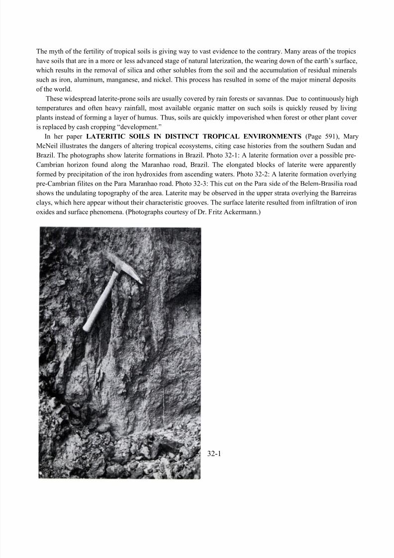
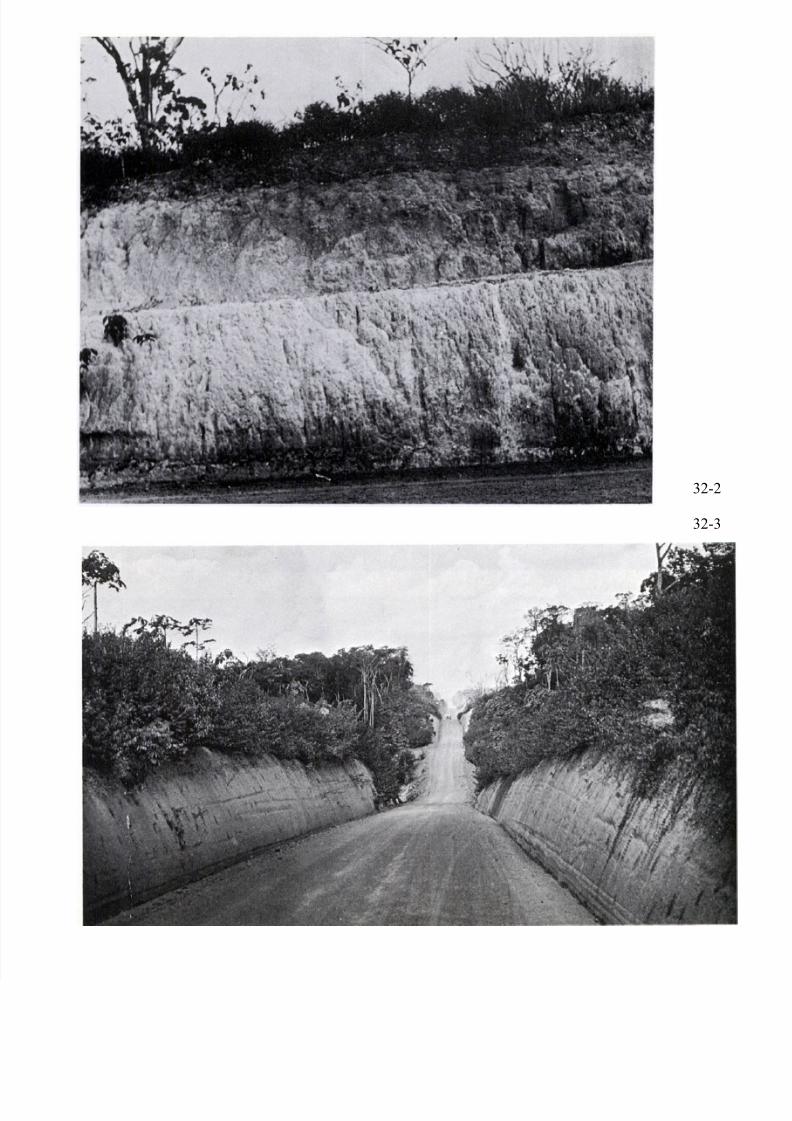
In her paper LATERITIC SOILS IN DISTINCT TROPICAL ENVIRONMENTS (Page 591), Mary
McNeil illustrates the dangers of altering tropical ecosystems, citing case histories from the southern Sudan and
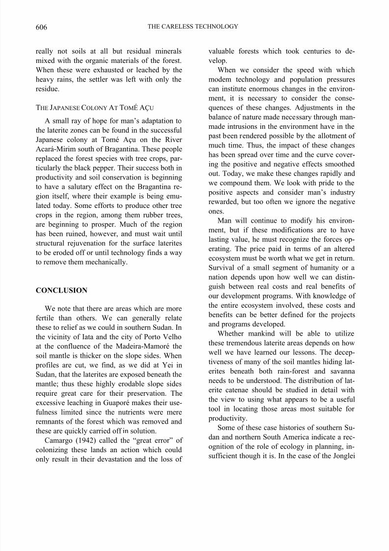
Brazil. The photographs show laterite formations in Brazil. Photo 32-1: A laterite formation over a possible pre-
Cambrian horizon found along the Maranhao road, Brazil. The elongated blocks of laterite were apparently
formed by precipitation of the iron hydroxides from ascending waters. Photo 32-2: A laterite formation overlying
pre-Cambrian filites on the Para Maranhao road. Photo 32-3: This cut on the Para side of the Belem-Brasilia road
shows the undulating topography of the area. Laterite may be observed in the upper strata overlying the Barreirasclays, which here appear without their characteristic grooves. The surface laterite resulted from infiltration of iron
oxides and surface phenomena. (Photographs courtesy of Dr. Fritz Ackermann.)
32-1
7/31/2019 Lateritic Soils in Distinct Tropical Environments
http://slidepdf.com/reader/full/lateritic-soils-in-distinct-tropical-environments 20/20
32-2
32-3